Transit - Oriented Development in a Changing Urban Corridor
|
|
|
- Brice Stokes
- 5 years ago
- Views:
Transcription
1 Transit - Oriented Development in a Changing Urban Corridor David E. Wohlwill, AICP Port Authority of Allegheny County Rail~Volution Chicago, IL November 7, 2006


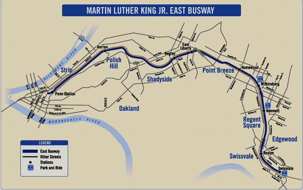
2 Martin Luther King, Jr. East Busway
3 East Busway Facts Opened in 1983 and extended in miles, 9 stations and 1 stop Port Authority s busiest BRT facility with 26,700 weekday riders (9/06) Links Downtown and Oakland with Pittsburgh s eastern neighborhoods and suburbs Allows buses to bypass severe congestion on major arterials and streets in Pittsburgh s eastern communities Mixture of express and local service Built along very active railroad line
4 Baum-Centre Corridor


5 Baum - Centre Corridor
6 Baum - Centre Corridor 1.6 miles in length With five neighborhoods interfacing in this corridor, the Baum - Centre Corridor has been dubbed the zipper joining these communities together


7 Early Automobile - Oriented Development By 1913, Baum Boulevard known as automobile row with 13 auto dealers First gasoline filling station in US Source: ExplorePAHistory.com Ford built an automobile assembly plant between Centre Ave. and Baum Blvd. Courtesy of Donald Dougherty
8 Maturing of the Baum - Centre Corridor The Ford plant shut down and many dealers closed Corridor continued to be automobileoriented with gasoline stations, auto parts stores, auto servicing, several remaining dealers and fast-food outlets Perception of the corridor being a noman s land due to the dearth of pedestrian activity and its location at the neighborhoods edges


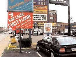
9 Maturing Corridor Dominated by Automobile-Oriented Uses
10 New Development begins to occur in the Corridor Opening of the Martin Luther King, Jr. East Busway in 1983 Over $500 million worth of development along East Busway Much of this development occurred in Baum - Centre Corridor Expansion of medical sector from its traditional base in Oakland to the Corridor University of Pittsburgh Medical Center (UPMC) Shadyside Hospital


11 New Development in Corridor UPMC Hillman Cancer Center Negley Station with Centre Professional Building in background
12 Development Opportunities in the Baum - Centre Corridor The Baum-Centre Corridor is a key conduit for travel to and within Pittsburgh s East End neighborhoods Proximity to Oakland (Pittsburgh s civic, educational and medical center) and to East End neighborhoods makes this corridor attractive to developers Closure of commercial enterprises and industrial operations has made property available for redevelopment
13 Planning Challenges in the Baum - Centre Corridor Rapid pace of development Large scale development Transforming automobile-oriented commercial strip development to pedestrian- and transit-oriented development Diversity of uses in adjacent communities and in the corridor Unmet neighborhood needs


14 City of Pittsburgh Plan for the Corridor


15 Vision Create a diverse, highquality urban district with easy access to public transportation and neighborhood serving businesses, with Baum Boulevard and Centre Avenue as boulevards.


16 Three Nodes in Corridor

17 North Oakland - Bloomfield

18 Redevelopment in Bloomfield New office and retail development with parking behind building


19 Reuse of Automobile Factories in Bloomfield Former Packard Motor Car Plant Now an Automobile Dealership Former Ford Plant Preservation/Reuse Opportunity

20 Shadyside-Bloomfield- Friendship


21 Development at Negley Station in Shadyside Expansion of Supermarket and New Condos at Negley Station

22 East Liberty


23 Eastside Development under construction East Liberty East Side Mixed Use Development (almost completed) and East Liberty Station First Whole Foods Store in City of Pittsburgh

24 Corridor extending east Nabisco Plant - East Liberty

25 Bakery Square Proposal for Reuse of the Nabisco Plant Preliminary concept subject to revision Courtesy of Walnut Capital


26 Proposal for New Station Serving the Corridor Site for station serving UPMC Hospital Area of potential sites for new station
27 Baum-Centre Initiative Citizens and stakeholders group formed to ensure plan s vision is carried out Comprised of residents from corridor neighborhoods and representatives from UPMC, Port Authority and local businesses A means for citizen input into plans for new development projects in the corridor Developers review project proposals with the group
28 In Conclusion... The Baum Centre Corridor initially developed with an automobile orientation As the corridor matured, many automobileoriented uses closed, creating opportunities for new development The corridor was attractive to developers Growth of the medical sector Corridor s function as a key conduit for access to and within Pittsburgh s East End communities Presence of the East Busway The City s Baum-Centre strategy and the Baum-Centre Initiative citizens group will help to guide development in the corridor

29 Author Contact Information David E. Wohlwill, AICP Lead Transit Planner Port Authority of Allegheny County
Project Area Master Plan City Council Presentation SHADYSIDE HOSPITAL Centre Avenue, Pittsburgh, PA 15232
 Project Area Master Plan City Council Presentation SHADYSIDE HOSPITAL 5230 Centre Avenue, Pittsburgh, PA 15232 UPMC SHADYSIDE STRATEGIC VISION UPMC Shadyside No bed growth 2% outpatient growth Master Facility
City of Long Beach. creating vibrant and exciting places
 City of Long Beach creating vibrant and exciting places Land Use Element Urban Design Element Overview of the two draft General Plan elements Discuss areas of change Economic goals of the plans Case study
Tyvola & Archdale Transit Station Area Plan. June 5, 2008
 Tyvola & Archdale Transit Station Area Plan Second Public Meeting June 5, 2008 Presentation Outline 1. Purpose and Process 2. Station Area Overview 3. Plan Recommendations 4. Comments Received and Proposed
Tysons Circulator Study: Process and Preliminary Results Summary. March 2012
 Tysons Circulator Study: Process and Preliminary Results Summary March 2012 Background: 1. The Comprehensive Plan for the Tysons Corner Urban Center calls for a System of Circulators in Tysons Corner to:
Repositioning Suburban Corridors: From Souless Strips to Something Better
 Repositioning Suburban Corridors: From Souless Strips to Something Better Moderator: Ed McMahon, Urban Land Institute Presenters: Takis Karatonis, Columbia Pike Revitalization Organization Mike Hallibaugh,
Citizen Comment Staff Response Staff Recommended Revision Planning Committee
 Citizen Comment Staff Response Staff Recommended Revision Planning Committee Area No. 1: Owner desires retail land uses. Area No. 1a: Owner of two small parcels adjacent to Area No. 1 desires retail land
Northwest commuter rail station US 36 BRT. Westminster Station
 Northwest commuter rail station Westminster Station US 36 BRT Westminster Center US 36 & Church Ranch Broomfield Flatiron/96 th St. US 36 & McCaslin Table Mesa Boulder Junction 13-month effort that will
Tyvola & Archdale Transit Station Area Plan. May 15, 2008
 Tyvola & Archdale Transit Station Area Plan First Public Meeting May 15, 2008 Presentation Outline 1. Purpose and Process 2. Station Area Overview 3. Plan Recommendations Vision Land Use Transportation
Cobb County Design Guidelines Mableton Parkway & Veterans Memorial Highway Community Design Workshop January 12, 2017
 Community Design Workshop January 12, 2017 Agenda Opening Remarks / Introductions Scope of Work Existing Conditions Key Issues / Opportunities VPS Summary Draft Vision & Goal Statement Implementation Concepts
International Blvd. TOD Plan Public Workshop #1
 International Blvd. TOD Plan Public Workshop #1 Add photos or project images September 21 and 22, 2010 Workshop Purpose Introduce the public to the Project Review and discuss the existing conditions analysis
b r a n c h av e n u e tr a n s it co r r i d o r r e vita lization pl a n a m o d el fo r s u b u r ban retro fit
 b r a n c h av e n u e tr a n s it co r r i d o r r e vita lization pl a n a m o d el fo r s u b u r ban retro fit P R I N C E G EO RG E S CO U NT Y, M D ADO PTED 0 p R O J E C T C AT E G O R Y : U R B
WALTER RAND TRANSPORTATION CENTER
 WALTER RAND TRANSPORTATION CENTER PLANNING AND DESIGN STUDY Public Meeting May 25, 2017 TONIGHT S AGENDA Introduction and Welcome Project Objectives The Study Area: WRTC and its Context Circulation Assessment
History: a Grand Urban Boulevard
 History: a Grand Urban Boulevard 1890 1910: At its peak, Euclid Avenue, "Millionaire's Row," was considered the second most beautiful urban street in the country next to Fifth Avenue in Manhattan. 1910-2030:
The Need to Develop a Transit Ready Community
 Evaluation & Appraisal Report (EAR) Major Issue # 6 The Need to Develop a Transit Ready Community July 3, 2007 EAR Major Issue # 6 Transit Ready Existing Comp Plan policies apply only to Indiantown Road:
A P P E N D I X B - O P P O R T U N I T Y S I T E S
 A P P E N D I X B - O P P O R T U N I T Y S I T E S OPPORTUNITY SITES As listed in the Land Use Element, the City has identified 15 Opportunity Sites expected to be the focus of change and revitalization
FUTURE LAND USE ELEMENT
 FUTURE LAND USE ELEMENT GOAL I: To create and sustain a great place to live, play, and prosper Objective 1: The City of Ocala shall incorporate the principles and strategies of the Ocala 2035 Vision into
Knoxville Area Transit (KAT) Transit Development Plan Corridor Analysis
 Transit Development Plan Corridor Analysis") Knoxville Area Transit (KAT) Transit Development Plan Submitted to: Knoxville-Knox County Metropolitan Planning Commission Submitted by: PB Americas, Inc. Under contract to: The Corradino Group, Inc. October
Knoxville Area Transit (KAT) Transit Development Plan Submitted to: Knoxville-Knox County Metropolitan Planning Commission Submitted by: PB Americas, Inc. Under contract to: The Corradino Group, Inc. October
Sub Area 2: Downtown Overland Park
 Downtown 132 2.12 encompasses over 600 acres and extends between 71st Street and 87 th Street including Downtown Overland Park. The area is home to several individual historic sites and structures, including
hermitage town center
 hermitage town center A Community Vision prepared by Strada for The City of Hermitage and The Mercer County Regional Planning Commission January 2007 table of contents introduction 3 design principles
Planning for TOD Implementation at a Corridor Scale
 Planning for TOD Implementation at a Corridor Scale Catherine Cox Blair, Reconnecting America Presentation to DRCOG and the Sustainable Communities Initiative May 14, 2012 What is Reconnecting America?
Table of Contents. Executive Summary... vii
 Table of Contents Executive Summary... vii Section I: Background...1 Introduction... 3 Study History... 3 Purpose and Role of the Plan... 6 Plan Organization... 7 The Estuary Shoreline... 11 Multiple Jurisdictions...
MONTGOMERY COUNTY METRO STATION AREA DESIGN CHARRETTE
 MONTGOMERY COUNTY METRO STATION AREA DESIGN CHARRETTE Shady Grove Metro Station Area Charrette Closing Presentation October 25-28, 2000 MONTGOMERY COUNTY, MD M-NCPPC Design Collective, Inc. Architects
Table of Contents. Elm Avenue Improvement Plan City of Waco, Texas. Introduction 1. Existing Context 1 Figure 1 2.
 Table of Contents Introduction 1 Existing Context 1 Figure 1 2 Plan Guidelines 3 Future Urban Form 4 The West-End 4 Main Street 6 The East-End 7 Figure 2 9 Public Improvement Recommendations 7 General
1.3 TRANSIT VISION 2040 FROM VISION TO ACTION THEME 1: PUTTING TRANSIT AT THE CENTRE OF COMMUNITIES. Fully integrate transit with community planning
 TRANSIT VISION 2040 FROM VISION TO ACTION TRANSIT VISION 2040 defines a future in which public transit maximizes its contribution to quality of life with benefits that support a vibrant and equitable society,
Rock Spring Master Plan Community Meeting #6: Land Use + Transportation Forecasts
 Rock Spring Master Plan Community Meeting #6: Land Use + Transportation Forecasts May 23, 2016 Ι Walter Johnson High School Andrea Gilles, andrea.gilles@montgomeryplanning.org Ι www.montgomeryplanning.org/community/rockspring/
Northwest Rail Corridor and US 36 BRT Development Oriented Transit Analysis 4.4 STATION AREA FINDINGS
 4.4 STATION AREA FINDINGS Each station is different, and each one requires a separate set of recommendations based on the vision for the site. This section outlines an initial TOD strategy and recommendations
PUBLIC MEETING April, 20161
 PUBLIC MEETING April, 20161 The Study Area Study Area Focus Area Corridor Neighbourhoods 2 Today s Presentation This material is aimed at providing viewers with enough background to be able to think about
What. - Civic anchors including a park and an updated library branch
 SUMMARY What Master Plan aimed at delivering - A walkable, mixed-use downtown in the heart of University City anchored by UNC Charlotte and University Research Park - Civic anchors including a park and
Chapter 4. Linking Land Use with Transportation. Chapter 4
 Chapter 4 Linking Land Use with Transportation Chapter 4 59 Chapter 4 Linking Land Use with Transportation Community Design and Transportation Program Introduction Since the 1950s, the predominant development
Gilbert Lindsay Plaza
 Gilbert Lindsay Plaza Gilbert Lindsay Plaza is a 5-acre landscaped pedestrian plaza situated along Figueroa Street that was developed and designed as the major urban outdoor amenity of the Los Angeles
TECHNICAL SUPPLEMENT 1: LAND USE AND ZONING
 TECHNICAL SUPPLEMENT 1: Albuquerque Rapid Transit Project Prepared for: Prepared by: Parsons Brinckerhoff, Inc. August 2015 TABLE OF CONTENTS 1.0 Project Description... 1 1.1 General Description of Existing
3 Denver RTD Light Rail
 3 Denver RTD Light Rail OVERVIEW: TRANSIT SYSTEM CHARACTERISTICS In October 1994, the Regional Transportation District (RTD) began service on its Central Corridor light rail line through the City of Denver.
ATTACHMENT A 09/12/2011. Attachment A - 1. A. Preliminary Future Transit Station Sub-area
 ATTACHMENT A A. Preliminary Future Transit Station Sub-area The Centers, Corridors and Wedges Growth Framework describes Transit Station Areas, which are sub-areas within Growth Corridors, as areas surrounding
MENDING A RIFT: Urbanism for North Tulsa, Oklahoma UNIVERSITY OF NOTRE DAME SCHOOL OF ARCHITECTURE 2017 GRADUATE URBAN DESIGN STUDIO
 MENDING A RIFT: Urbanism for North Tulsa, Oklahoma UNIVERSITY OF NOTRE DAME SCHOOL OF ARCHITECTURE 2017 GRADUATE URBAN DESIGN STUDIO Project Description Mending A Rift: Urbanism for North Tulsa focuses
Eastern Terminus TECHNICAL MEMORANDUM CENTRAL BROWARD EAST-WEST TRANSIT ANALYSIS BROWARD COUNTY, FLORIDA
 Eastern Terminus TECHNICAL MEMORANDUM CENTRAL BROWARD EAST-WEST TRANSIT ANALYSIS BROWARD COUNTY, FLORIDA FINANCIAL PROJECT ID NUMBER 411189-2-22-01 FLORIDA DEPARTMENT OF TRANSPORTATION DISTRICT 4 Prepared
Goals and Objectives. Garfield Blvd. Washngton Park
 N 3 Neighborhood, Node, and Network Red Line Metra State St Green Line Garfield Blvd Washngton Park Land Use Plan Mixed use Commercial Institutional Open space Goals and Objectives I. Neighborhood: Enhance
CRENSHAW TRANSIT CORRIDOR DRAFT EIS/EIR Executive Summary SUMMARY OF IMPACTS. ES.16 Summary of Impacts. Page ES-41
 SUMMARY OF IMPACTS purposes as they are considered in the overall financial capability of Metro along with the other alternatives under consideration. The capital cost methodology and capital cost estimates
EXISTING COMPREHENSIVE PLAN
 EXISTING COMPREHENSIVE PLAN Town Center Land Use Element: V. LAND USE POLICIES Town Center Mercer Island's business district vision as described in "Your Mercer Island Citizen-Designed Downtown" was an
Midtown Corridor Alternatives Analysis. Appendix A - Initially Considered Alternatives Screening
 Midtown Corridor Alternatives Analysis Appendix A - Initially Considered Alternatives Screening Arterial BRT on Lake Street - Overall Rating: RATING Metropolitan Council recommendations stated in the Transportation
The Glenn Dale-Seabrook-Lanham communities are served by a number of commercial
 10 Commercial and Employment Areas The Glenn Dale-Seabrook-Lanham communities are served by a number of commercial areas that were developed over the past several decades along arterial roads and at key
Land Use. Hardware Street Vendor Mixed-Use
 Land Use Definition Land Use is the way a piece of real estate is utilized. Existing, proposed, and adopted land uses all play a role in the planning process. Once a land use plan is adopted, the next
Cumberland Region Tomorrow is a private, non-profit, citizen based regional organization working with Greater Nashville Regional Council
 Cumberland Region Tomorrow is a private, non-profit, citizen based regional organization working with Greater Nashville Regional Council and others in the public and private sectors, dedicated to planning
Route 5 Corridor Land Use and Transportation Plan
 N Y S M P O Integrated Transportation Planning & Community Design Processes ALBANY Great streets do not just happen... They are streets for both pedestrians and drivers. They have definition, a sense of
New Urbanism Theory and Practice
 New Urbanism Theory and Practice New Urbanist principles Established neighborhoods Recent attempts at New Urbanist design CE512 New Urbanist Principles Neighborhoods compact, pedestrian-friendly, and mixed-use.
Integrated Urban Development. April Reflections from the NZPI Study Tour of Portland, Seattle and Vancouver
 Integrated Urban Development April 2009 Reflections from the NZPI Study Tour of Portland, Seattle and Vancouver Integrated Urban Development Urban Growth Management Transportation Transit Orientated Mixed
Economic Development and BRT. Cliff Henke Sr. Analyst, Parsons Brinckerhoff John Noel Public Transit Discovery Conference, Addison, IL October 2010
 Economic Development and BRT Cliff Henke Sr. Analyst, Parsons Brinckerhoff John Noel Public Transit Discovery Conference, Addison, IL October 2010 Topics Today The BRT- Economic Link Example Projects Latest
Gold Line Bus Rapid Transit Transit Oriented Development (BRTOD) Helmo Station Area Plan
 Helmo Station Area Plan") Appendix F Gold Line Bus Rapid Transit Transit Oriented Development (BRTOD) Helmo Station Area Plan Introduction and Purpose of the Plan The Gold Line Bus Rapid Transit facility is an eleven-mile dedicated
Appendix F Gold Line Bus Rapid Transit Transit Oriented Development (BRTOD) Helmo Station Area Plan Introduction and Purpose of the Plan The Gold Line Bus Rapid Transit facility is an eleven-mile dedicated
Bethesda Downtown Plan
 Bethesda Downtown Plan Planning Board Update Connecticut Avenue Location Economic Sustainability Social Environmental Scope Coming Soon! Team Listening, Twitter Outreach We Are Here Engagement Challenge
ALMONO. Hazelwood, City of Pittsburgh. A riverfront investment opportunity combining residential, office and light industrial uses A L M O N O S I T E
 Tecumseh St. ALMONO Hazelwood, City of Pittsburgh A riverfront investment opportunity combining residential, office and light industrial uses Downtown Pittsburgh Oakland South Side Flats Birmingham Bridge
TRANSIT-ORIENTED DEVELOPMENT PLAN PRESENTATION RED-PURPLE BYPASS PROJECT AREA
 TRANSIT-ORIENTED DEVELOPMENT PLAN PRESENTATION RED-PURPLE BYPASS PROJECT AREA Purpose Create a community-led vision for redevelopment in the neighborhood Test specific concepts for CTA-owned parcels Expedite
Community Meeting #2.1
 Community Meeting #2.1 Thursday, October 20, 2016, 7:00 p.m. to 9:00 p.m. Eliot Elementary School, 475 Old Gilroy Street, Gilroy, CA 95020 Meeting Summary The City of Gilroy held its third community meeting
East Central Area Plan
 East Central Area Plan Steering Committee Meeting March 8 th, 2018 CHUN Tears McFarlane House Vision Statement Development Opportunities Analysis Vision Elements 1. Equitable, Affordable and Inclusive
Public input has been an important part of the plan development process.
 Lakewood s Comprehensive Plan recognizes that transportation helps shape the community, and that the way the community provides for the safe and efficient movement of people affects the character of the
Corridors. Re-vitalize our Corridors and Gateways
 Corridors Re-vitalize our Corridors and Gateways Artist s rendering from the 287 Strategic Plan, 2015 Corridors are the major throughways of Loveland but they also provide important commercial, community
Harlem Avenue Corridor Plan: Corridor Planning Across Municipal Boundaries
 Harlem Avenue Corridor Plan: Corridor Planning Across Municipal Boundaries Heather Tabbert, Manager, Local Planning and Programs Division Regional Transportation Authority (RTA) Jen McNeil Dhadwal, Principal
Citizen Advisory Group Meeting 5: Land Use April 14, 2011
 Citizen Advisory Group Meeting 5: Land Use April 14, 2011 Meeting Agenda 1. Background Review 2. Transportation Follow-up 3. PED Overlay Approach 4. Land Use Mapping 5. Group Exercise 6. Wrap-up and Next
3. Endorse the LRT vision in transforming Surrey into Connected-Complete-Livable communities, and more specifically, the official vision statement:
 CORPORATE REPORT NO: R038 COUNCIL DATE: February 20, 2017 REGULAR COUNCIL TO: Mayor & Council DATE: February 16, 2017 FROM: General Manager, Engineering FILE: 8740-01 SUBJECT: Surrey Light Rail Transit
New Partners for Smart Growth Conference February 5, 2010
 Dan Stroh, Planning Director City of Bellevue Planning and Community Development Bellevue, WA New Partners for Smart Growth Conference February 5, 2010 Summary of Project Long-range plan update for Bel-Red
Eastern Gateway / 7 Corners. City of Falls Church & Fairfax County May 14, 2013
 Eastern Gateway / 7 Corners City of Falls Church & Fairfax County May 14, 2013 Eastern Gateway Concept Plan Current Conditions Vision & Goals Building Potential Transportation Circulator to East Falls
COMMUNITY OPEN HOUSE. March 28, 2012
 COMMUNITY OPEN HOUSE March 28, 2012 THE CASE FOR URBAN INVESTMENT One of the best things that cities can do to create jobs especially in the private sector is to improve the quality of life of their inhabitants.
Wasatch CHOICE for 2040
 Wasatch CHOICE for 2040 Economic Opportunities We Can Choose a Better Future We enjoy an unparalleled quality of life along the Wasatch Front. People from all over the world are drawn to our stunning scenery,
TOD 101 CREATING LIVABLE COMMUNITIES WITH TRANSIT
 1 CREATING LIVABLE COMMUNITIES WITH TRANSIT What are transit Centered Communities? Benefits of Partnerships to Support and Implement What You Will Learn Portland s Pearl District Your Trainers Today Catherine
Embrace Green Urban Space:
 1 Embrace Green Urban Space: Parks/Green Space as Vital to Urban Livability Jenna Fletcher The Trust for Public Land LUAC November 15, 2012 2 The Trust for Public Land conserves land for people to enjoy
ITEM #8. Regional Smart Growth Program. Regional Smart Growth Program. Presentation Overview. Coast Highway Vision and Stategic Plan.
 Regional Smart Growth Program Economic Development Commission What is Smart Growth? Adopted as part of the Regional Comprehensive Plan (RCP) RCP provides vision for region based on Smart Growth and sustainability
April 21, 2007 CCRP Workshop Summary
 April 21, 2007 CCRP Workshop Summary Group 1 1. Reuse around BART with a lot of housing and jobs 2. Greenway around creek 3. Transit and auto connection all through the site from Kirker Pass to Port Chicago
INDEPENDENCE BOULEVARD AREA PLAN
 INDEPENDENCE BOULEVARD AREA PLAN Public Meeting October 28, 2008 Tonight s Agenda Introduction 4:00 4:05 Tom Warshauer Presentation 4:05 5:00 Blake Drury Group Exercises 5:00 5:50 All Wrap Up & Next Steps
3. Urban Design in the Central Area
 3. Urban Design in the Central Area The Central Area Planning and Design Group assumes the responsibility to promote high quality urban and architectural design in the Central Area, plan and ensure the
A. WHAT IS A GENERAL PLAN?
 I. Introduction A. WHAT IS A GENERAL PLAN? A general plan is the planning guideline for the future of a city. It contains goals and policies which regulate urban development, the protection of the natural
City Center Specific Plan Amendments And Background Report City of Richmond. PLANNING COMMISION FINAL DRAFT January, 2001
 City Center Specific Plan Amendments And Background Report City of Richmond PLANNING COMMISION FINAL DRAFT January, 2001 TABLE OF CONTENTS Page LIST OF TABLES... LIST OF FIGURES... INDEX... OVERVIEW...
Status Report: MD 355 Project
 Status Report: MD 355 Project OCTOBER 2006 M-NCPPC MONTGOMERY COUNTY PLANNING DEPARTMENT Summary of Community Comments, and break to the Results of the MD 355 Participation Session Brookside Gardens -
County Council Presentation. White Oak Science Gateway Planning Board Draft Master Plan June 17, 2014
 County Council Presentation White Oak Science Gateway Planning Board Draft Master Plan June 17, 2014 http://montgomeryplanning.org/community/wosg/index.shtm Nancy Sturgeon, Lead Planner www.nancy.sturgeon@montgomeryplanning.org
Planning for TOD Implementation at a Corridor Scale
 Planning for TOD Implementation at a Corridor Scale Bill Sadler, Reconnecting America Presentation to Gold Line Corridor Working Group July 2, 2013 What is Reconnecting America? Reconnecting America is
The State Road 7/U.S. 441 Collaborative. 8 th Annual New Partners for Smart Growth Building Safe, Healthy and Livable Communities
 The State Road 7/U.S. 441 Collaborative 8 th Annual New Partners for Smart Growth Building Safe, Healthy and Livable Communities J. Gary Rogers City of Lauderdale Lakes Florida Community Redevelopment
Stakeholders Advisory Working Groups (SAWGs) Smart Growth and TOD Land Use (#11) SAWG Meeting
 Smart Growth and TOD Land Use (#11) SAWG Meeting") Presentation - Part II Tappan Zee Bridge/I-287 Corridor Project July 21, 2010 Slide 1. David Kooris (Regional Plan Association) welcomed members of the Land Use Stakeholders Advisory Working Groups (SAWGs)
Presentation - Part II Tappan Zee Bridge/I-287 Corridor Project July 21, 2010 Slide 1. David Kooris (Regional Plan Association) welcomed members of the Land Use Stakeholders Advisory Working Groups (SAWGs)
Midtown Greenway Land Use and Development Plan Executive Summary
 Midtown Greenway Land Use and Development Plan Executive Summary Introduction The Midtown Greenway Land Use and Development Plan sets policy direction for land use and development in the Midtown Greenway
City of Ennis. Downtown Master Plan Catalyst Projects
 City of Ennis Downtown Master Plan Catalyst Projects Revised Framework Plan REVISED Project Types and Descriptions Project Types A. Visitor Attracting Projects: Projects in this category are intended to
Screen 1 Corridors and Profiles Evaluated
 Corridors and Profiles Evaluated Universe of Corridors and Profiles Considered CORRIDORS PROFILES I-57 Expressway Halsted Street UP Railroad Wentworth Avenue State Street Michigan Avenue King Drive Cottage
North Central Texas APA Transit-Oriented Development Seminar. Case Study City of North Richland Hills TOD. February 20, 2009
 North Central Texas APA Transit-Oriented Development Seminar Case Study City of North Richland Hills TOD February 20, 2009 1. Background TOD Code Adoption 2. Regulating Plans 3. Street Types 4. Special
FRUITVALE TRANSIT VILLAGE (Phase 2) Residential Project
 Residential Project") FRUITVALE TRANSIT VILLAGE (Phase 2) Residential Project DEVELOPER: SIGNATURE PROPERTIES ARCHITECT: HKIT ARCHITECTS April 23, 2010 TABLE OF CONTENTS 3 Vision 4 Description of Site 5 Guiding Concepts 6
FRUITVALE TRANSIT VILLAGE (Phase 2) Residential Project DEVELOPER: SIGNATURE PROPERTIES ARCHITECT: HKIT ARCHITECTS April 23, 2010 TABLE OF CONTENTS 3 Vision 4 Description of Site 5 Guiding Concepts 6
AUTO CIRCULATION & PARKING
 CHAPTER 5 Chapter 5 Auto Circulation & Parking AUTO CIRCULATION & PARKING Parking use and automobile circulation have been topics of many discussions on street corners as well as at public workshops and
Subarea 4 Indian Creek. Vision The combination of park networks and transportation amenities make Subarea 4 the greenest hub in the Corridor.
 indian creek 180 extends south from 101st Street to I-435. The I-435 and Metcalf intersection is one of the primary intersections in the Kansas City Metro Area. The area includes several residential neighborhoods
9/19/2018 TODAY S WEBINAR AGENDA CONTINUING EDUCATION UPCOMING TRAINING FROM APBP
 TODAY S WEBINAR AGENDA 3:00 pm: Introduction 3:05 pm: Presentation 3:45 pm: Questions 4:00 pm: Webinar Ends For technical assistance during the webinar: 1-800-263-6317 Choose these prompts: 1, 1, 1 CONTINUING
Edward R. Sajecki Commissioner of Planning and Building
 Corporate Report Clerk s Files Originator s Files CD.04.HUR DATE: TO: FROM: Chair and Members of Planning and Development Committee Meeting Date: April 14, 2014 Edward R. Sajecki Commissioner of Planning
THE 355/270 CORRIDOR:
 THE 355/270 CORRIDOR: Strategic Ideas for Sustaining a Livable Work Place Project Summary ACCESS LIFE DESIGN HEALTH WORK Montgomery County Planning Department The Maryland-National Capital Park and Planning
Rio/29 Future Land Use Alternatives. Rio/29 Small Area Plan Phase 1 December 12, 2016
 Rio/29 Future Land Use Alternatives Rio/29 Small Area Plan Phase 1 December 12, 2016 PRESENTATION OVERVIEW 1 BACKGROUND 2 COMMUNITY INPUT 3 DESIGN PRINCIPLES 4 5 ALTERNATIVES OPEN HOUSE 2 1 PROJECT BACKGROUND
Table L-1 Summary Action Strategy. Action Item Timing Status Responsible Agency
 CHAPTER 4: CIRCULATION ELEMENT ISSUE #1: MAJOR THOROUFARES AND TRANSPORTATION ROUTES A balanced transportation system for Fontana is provided that meets the mobility needs of current and future residents
Shift Rapid Transit Public Participation Meeting May 3, 2017
 Shift Rapid Transit Public Participation Meeting May 3, 2017 Shift Rapid Transit Initiative Largest infrastructure project in the city s history. Rapid Transit initiative will transform London s public
V. Case Study Sites. Case Study Site Descriptions and Concepts. Case Study #1: Lake Street and Calhoun
 V. Case Study Sites The project area includes a wide variety of neighborhood contexts with diverse development opportunities. To better understand these contexts and how they affect choices concerning
Presentation to Town Council in association with Kubilins Transportation Group Rose & Associates Equinox Environmental
 Presentation to Town Council 03.03.09 in association with Kubilins Transportation Group Rose & Associates Equinox Environmental Vision Statement: Boone 2030 is...a friendly, vibrant, attractive community...financially,
DRAFT ROOSEVELT ROAD. District Recommendations. Figure 5.23 The Roosevelt Road Corridor
 CHAPTER 5 Figure 5.23 The Road Corridor Road will develop as a mixed-use corridor, emphasizing regional retail, west of the river and mixed-use development east of the river. KEY RECOMMENDATIONS 1. High
PROTOTYPE DESIGN/INTRODUCTION
 PART III: PROTOTYPE DESIGN These concepts and guidelines described earlier were used to develop a prototype design for an emerging suburban area located west of the City of Milwaukee. This was done to
South of Eastern Strategic Direction Status Update
 STAFF REPORT ACTION REQUIRED South of Eastern Strategic Direction Status Update Date: July 10, 2014 To: From: Planning and Growth Management Committee Chief Planner and Executive Director, City Planning
LEED-ND 101: Practical Strategies for Achieving Sustainability Goals. Travis Parker Lakewood Planning Director
 LEED-ND 101: Practical Strategies for Achieving Sustainability Goals Travis Parker Lakewood Planning Director Metro Vision Idea Exchange Oct 11, 2012 West Corridor Stations West Corridor Overview West
Corridor-Level Approaches to Creating Transit-Oriented Districts
 Corridor-Level Approaches to Creating Transit-Oriented Districts Dena Belzer Strategic Economics and Center for Transit-Oriented Development August 2011 5-year old partnership dedicated to improving practice
EXPO LINE COMMUNITY WORKSHOPS NOVEMBER 27 TH & DECEMBER 3 RD Los Angeles Department of City Planning
 EXPO LINE COMMUNITY WORKSHOPS NOVEMBER 27 TH & DECEMBER 3 RD 2012 Los Angeles Department of City Planning Agenda for Tonight Open House 6:00 to 6:15pm Presentation and Questions 6:15 to 6:50 Small Group
5-AUTOMOBILE CIRCULATION & PARKING
 5-Automobile Circulation & Parking 5-AUTOMOBILE CIRCULATION & PARKING Parking and automobile circulation are always popular topics for downtowns. Citizen concerns in Georgetown have to do with high traffic
Equitable Growth Through TOD Planning
 Equitable Growth Through TOD Planning Community Meeting # 2 November 2017 Goals Objectives Extend investment from downtown Connect neighborhoods physically and economically Enhance places based on local
WELCOME and introduction
 1 WELCOME and introduction Mobility Hub Locations within Burlington STUDY OVERVIEW STUDY OBJECTIVES The City of Burlington is developing four Area Specific Plans, one for each of Burlington s Mobility
124 Subarea Visions. Vision Plan. A. Nelessen Associates, INC I Visioning I Planning I Urban Design
 Subareas 124 Subarea Visions The next seven sections describe specific recommendations tailored to each subarea. Each subarea is discussed separately except for certain aspects of 95th Street and Antioch
TRANSIT SUPPORTIVE DEVELOPMENT ANALYSIS
 7 TRANSIT SUPPORTIVE DEVELOPMENT ANALYSIS One of the key comments heard over and over through the public involvement process was that the region needs a more robust transit system to provide a viable alternative