MENDING A RIFT: Urbanism for North Tulsa, Oklahoma UNIVERSITY OF NOTRE DAME SCHOOL OF ARCHITECTURE 2017 GRADUATE URBAN DESIGN STUDIO
|
|
|
- Monica Small
- 5 years ago
- Views:
Transcription


1 MENDING A RIFT: Urbanism for North Tulsa, Oklahoma UNIVERSITY OF NOTRE DAME SCHOOL OF ARCHITECTURE 2017 GRADUATE URBAN DESIGN STUDIO


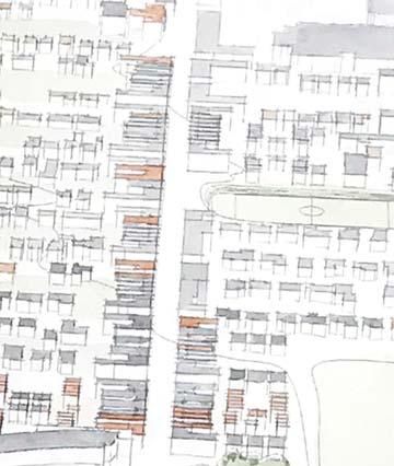
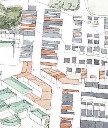
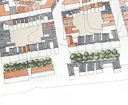
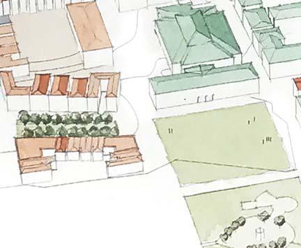
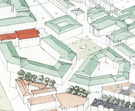
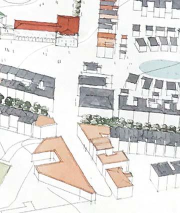
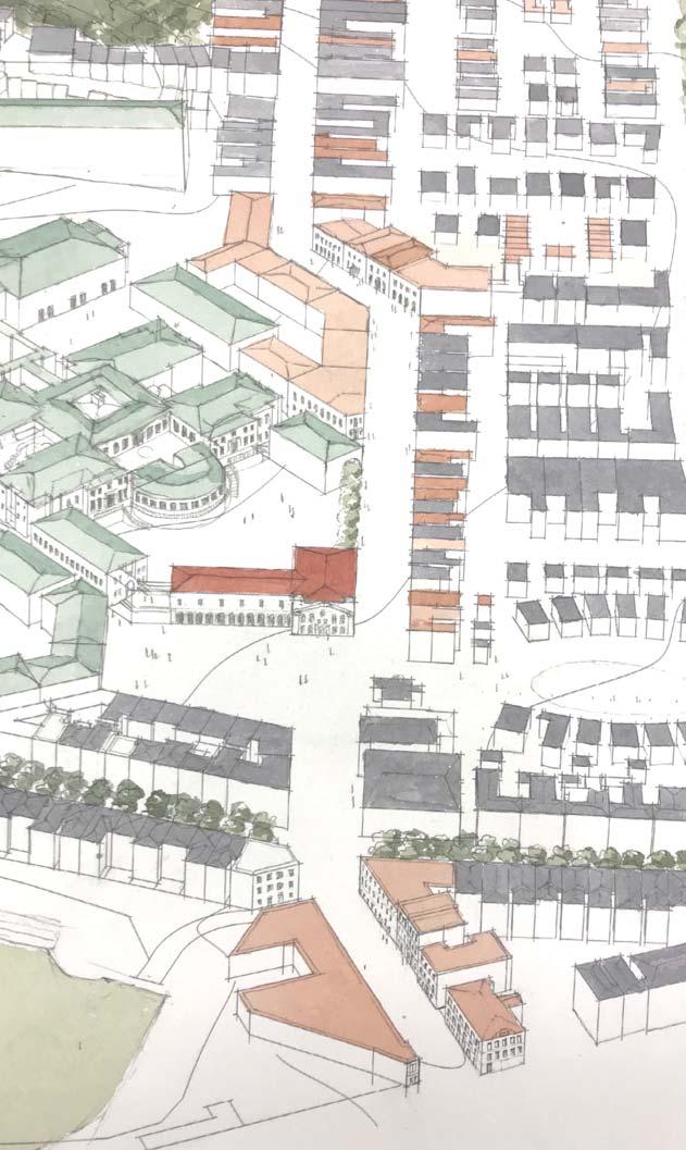
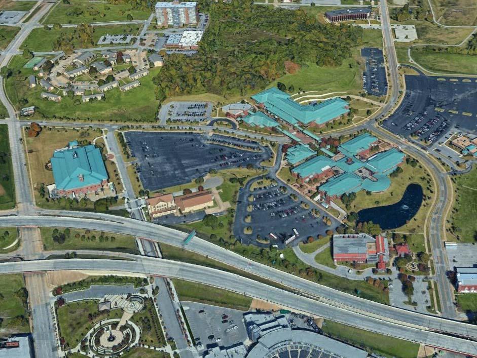
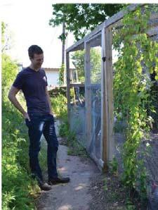
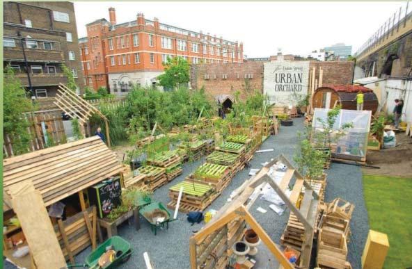
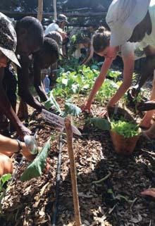
2 Project Description Mending A Rift: Urbanism for North Tulsa focuses on a one-square-mile site immediately north of downtown Tulsa, adjacent to the Arts District, a downtown hub of Millennial and Gen-x activity, but cut off by the Crosstown Expressway. Over the course of the 20th Century, Greenwood was twice ravaged. On June 1, 1921, Black Wall Street and large swaths of Greenwood were razed by white rioters, who dropped home-made bombs from WWI era bi-planes. Greenwood recovered in later decades, but was largely demolished again by 1960s Urban Renewal and replaced by the Crosstown Expressway and the University Center at Tulsa. These together today occupy some 150 acres formerly occupied by homes and businesses; and our entire site is now a food desert, with only 2,800 residents within its square-mile-plus boundary. and/or residential purposes. In Phase III, Greenwood Avenue and Martin Luther King Jr. Boulevard become north-south corridors of development that reach Pine Street, the northern border of the site. In the area bounded by these three streets, we recommend removing the 1970s culs-de-sacs that back properties onto these major thoroughfares in order to reconnect the street network and allow new buildings to front and spatially contain important streets. PROJECT SITE (DOWNTOWN SHOWN BELOW) The site is home to two historic neighborhoods, Brady Heights to the west and Greenwood to the east. Under Tulsa s early 20th Century Jim Crow laws, Greenwood was the legally segregated black neighborhood in town, with 10,000 residents occupying its 400 acre precinct. Thus, though Tulsa boomed -- the new oil capital of the world -- most of the wealth remained within the art deco high-rises downtown and with those who owned them. Nevertheless, within the economic isolation of Greenwood, what was known as Black Wall Street also African-American community. A multiracial consortium of public and private interests invited us to study this area, challenging us to balance critical issues of history, memory, justice, and the economic opportunity represented by so much vacant land proximate to new growth. We envision and recommend development on our site in three phases. Phase I, entailing no demolition of existing buildings, proposes a new mixed-use Five Points neighborhood to the southwest, a new BMX Arena and National Headquarters district to the southeast, and the block-scale seeds of a new Black Wall Street at the southern end of Greenwood all site neighborhoods two-to-three-story missing-middle housing and mixed-use building types needed to (re)create the density required to support grocery stores and other pedestrian-proximate retail uses, which density we calculate to be 15,000-25,000 people per square mile. 1920S ART DECO TULSA THE DESTRUCTION OF GREENWOOD 1921 In Phase II, development continues north along Greenwood Avenue. A new Greenwood Cultural Center and the existing Vernon Chapel prominently sit on a new Greenwood Plaza. The Tulsa campuses of Oklahoma State University and Langston University are envisioned as urban campuses, not unlike the University of Chicago or the College of Charleston. In this formal model, University-owned- the public character of the street, can Working in tandem with existing local initiatives to promote permaculture gardening on currently vacant land, we propose a linear urban market on MLK Jr. Boulevard, akin to historic precedents such as the Charleston Market. The new market building would be proximate to the largest portions of the site dedicated to permaculture: the southern facing slopes of a large hill to the southeast, and the gardens adjoining a Public Montessori School to the near southwest. Finally, we imagine re-urbanizing the Crosstown Expressway, replacing it with a new Crosstown Boulevard boasting a spacious green median in a 150- foot R.O.W. lined by four-to-six-story residential buildings. An edge shared by distinct neighborhoods, the new Crosstown Boulevard would become a new urban center in its own right. PROJECT DESCRIPTION 1
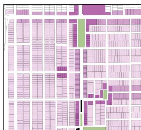
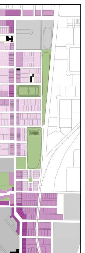
 P H A S E II: OSU-T U L S A & L A N G S TO N ; G R E E N W O O D A V E N U E ( B L A C K W A L L S T R E E T ); G E N E R A L S I")
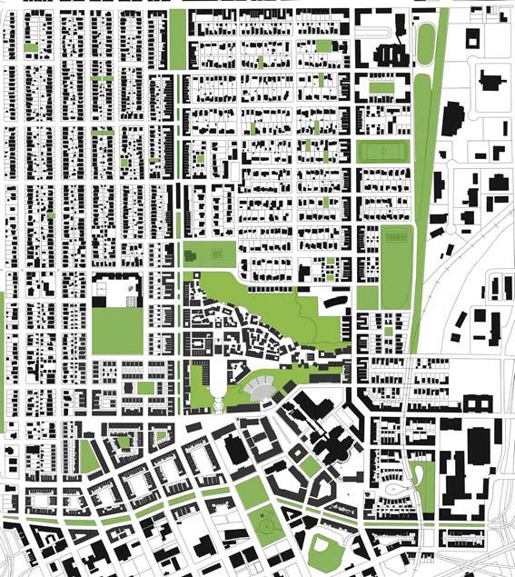
; F I N A L G E N E R A L S I T E I N F I L L 0 P RO J E C T S I T E / M A S T E R P L A N P H A S I N G 400 800 N 1600 2")
3 P H A S E I: F I V E P O I N T S N E I G H B O R H O O D (S O U T H W E S T ); BMX N AT I O N A L H E A D Q U A RT E R S (S O U T H E A S T ); G E N E R A L S I T E I N F I L L (N O D E M O L I T I O N ) P H A S E II: OSU-T U L S A & L A N G S TO N ; G R E E N W O O D A V E N U E ( B L A C K W A L L S T R E E T ); G E N E R A L S I T E I N F I L L P H A S E III: P I N E S T R E E T (N O RT H ); MLK B O U L E VA R D (C E N T E R L E F T ); G R E E N W O O D A V E N U E (C E N T E R R I G H T ); C R O S S TO W N B O U L E VA R D (S O U T H ); F I N A L G E N E R A L S I T E I N F I L L 0 P RO J E C T S I T E / M A S T E R P L A N P H A S I N G N


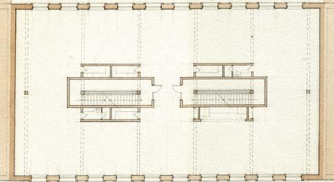
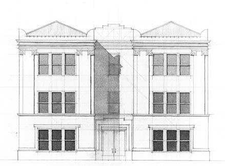
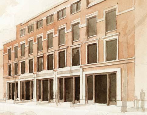
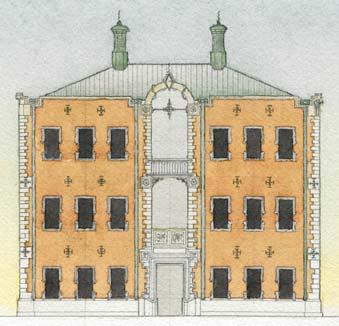
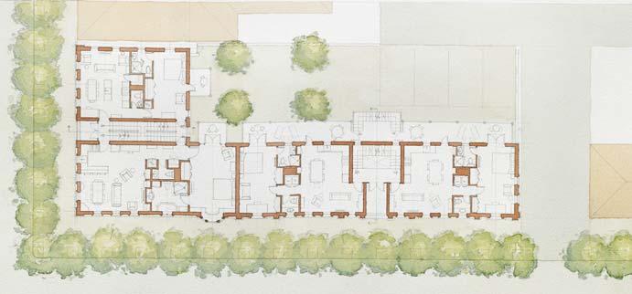
4 MIXED-USE BUILDING LOFT BUILDING CORNER LOT TWELVE-FLAT SIX-FLAT STUDENT DESIGNS FOR PROPOSED MISSING MIDDLE HOUSING 1 3
 FIVE")


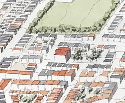
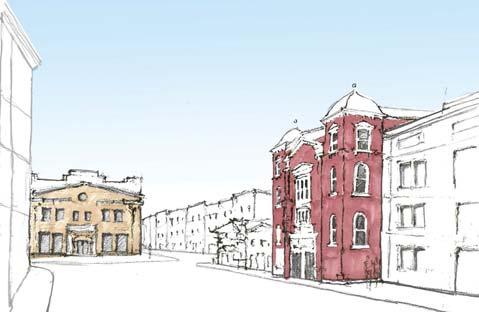
5 FIVE POINTS NEIGHBORHOOD MASTER PLAN (HALF-MILE DIAMETER) FIVE POINTS - PROPOSED AERIAL FIVE POINTS FIVE POINTS - PRESENT FIVE POINTS - PROPOSED FIVE POINTS: PAST, PRESENT, FUTURE 4

")
")


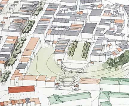
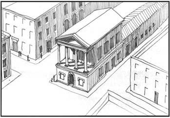
6 BLACK WALL STREET - VERNON CHAPEL (1950) BLACK WALL STREET - VERNON CHAPEL (PRESENT) BLACK WALL STREET - VERNON CHAPEL (PROPOSED) GREENWOOD PLAZA AND AVENUE (PROPOSED) REDEVELOPMENT OF GREENWOOD AVENUE 5


7 UNIVERSITY OF CHICAGO OSU - STILLWATER OSU - TULSA & LANGSTON UNIVERSITY EXISTING OSU - TULSA & LANGSTON UNIVERSITY PROPOSED OSU - TULSA & LANGSTON UNIVERSITY EXISTING OSU - TULSA & LANGSTON UNIVERSITY PROPOSED UNIVERSITY CENTER AT TULSA 6


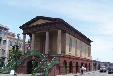
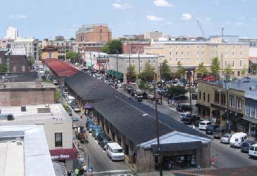
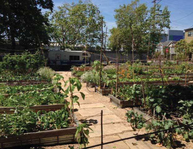
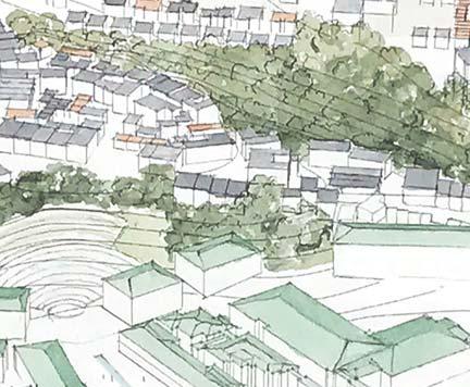
8 PROPOSED MLK MARKET BUILDING (CHARLESTON PRECEDENT) PROPOSED GREEN WEAVE (INCLUDING PERMACULTURE GARDENS BUILDING ON EXISTING INITATIVES IN TULSA) PERMACULTURE - TO - MARKET PROJECT 7


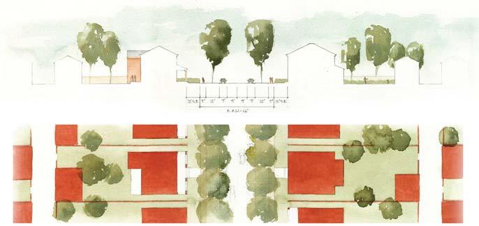
9 EXISTING CROSSTOWN EXPRESSWAY PROPOSED CROSSTOWN BOULEVARD TULSA EXPRESSWAY SYSTEM, BEFORE AND AFTER PROPOSED BOULEVARD SECTION CROSSTOWN BOULEVARD 8
")

")

 MAIN")

 and")


10 GREENWOOD NEIGHBORHOOD STREET 2,800 PEOPLE / SQ. MILE DETACHED SINGLE FAMILY HOUSES (1-2 STORIES) JOHN HOPE FRANKLIN BLVD, EXISTING EXISTING CUL-DE-SACS IN NORTH GREENWOOD CHICAGO RAILROAD SUBURB STREET 7,000 PEOPLE / SQ. MILE DETACHED SINGLE FAMILY HOUSES (2-3 STORIES) JOHN HOPE FRANKLIN BLVD, PROPOSED CUL-DE-SAC DEMOLITION CHICAGO NEIGHBORHOOD STREET 28,000 PEOPLE / SQ. MILE MISSING MIDDLE HOUSING (2-3 STORIES) MAIN STREET, EXISTING THE IMPORTANCE AND CHARACTER OF DENSITY Key to restoring 1920s Greenwood prosperity is restoring 1920s Greenwood density (approximately 16,000 people per square mile) and mix of uses. Street views above illustrate how such density can be achieved in 2-3 story buildings that include dwelling types ranging from single-family houses to six-unit apartment buildings. RECONNECTED STREETS WITH NEW DEVELOPMENT MAIN STREET, PROPOSED CONNECTED STREETS & URBAN DENSITY 9
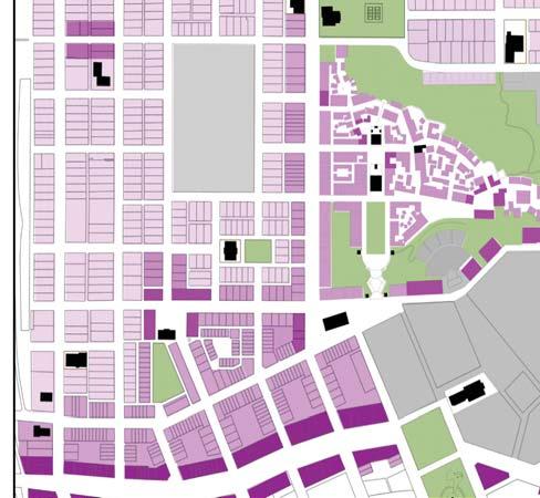
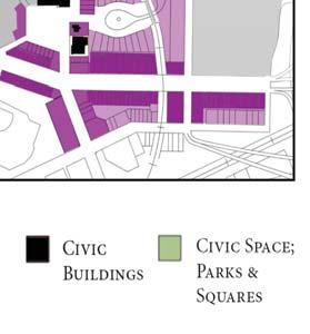
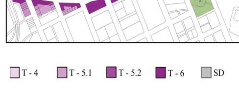
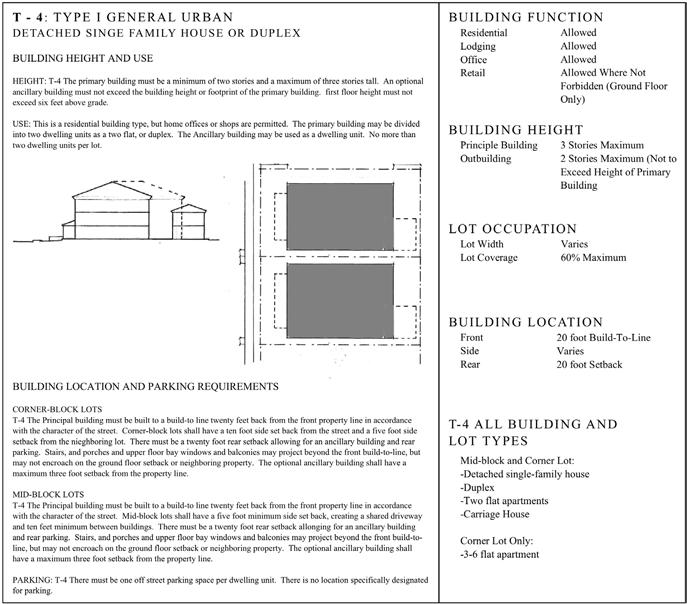
11 NEIGHBORHOOD STREET TYPE A (66 FT R.O.W.) REGULATING PLAN AND SAMPLE CODE PAGES 10
EcoVerde MADISON TO DOWNTOWN TO BEACH. Legend Highway Major Connection Major Street Local Street Proposed Access. Response to Tropicana Field RFP
 EcoVerde TO BEACH 275 16th Street North 16th Street South 13th Street North 13th Street South 11th Street North 11th Street South 1st Avenue North Central Avenue 1st Avenue South TO DOWNTOWN 2nd Avenue
Page 1 of 19 URBAN DESIGN FRAMEWORK FOR BOLTON STREET WATERFORD
 Page 1 of 19 URBAN DESIGN FRAMEWORK FOR BOLTON STREET WATERFORD 1.0 Introduction: The relocation of the City Council stores and depot from Bolton Street creates an exciting opportunity for development
A P P E N D I X B - O P P O R T U N I T Y S I T E S
 A P P E N D I X B - O P P O R T U N I T Y S I T E S OPPORTUNITY SITES As listed in the Land Use Element, the City has identified 15 Opportunity Sites expected to be the focus of change and revitalization
Jason D. Sutphin, Community Development Division Chief. Through: Brooke Hardin, Director of Community Development and Planning
 Meeting Date: 12/18/2017 Agenda Item: 9a. MEMORANDUM To: Chairman Cunningham and Members of the Planning Commission From: Jason D. Sutphin, Community Development Division Chief Through: Brooke Hardin,
ACSA/AIA Housing Design Education Award
 ACSA/AIA Housing Design Education Award 2014-2015 Winner: Submission Materials FOUR URBAN HOUSING NARRATIVES: Getting the City to be a Master Developer STEPHEN D. LUONI University of Arkansas JEFFREY ERWIN
FUTURE LAND USE ELEMENT
 FUTURE LAND USE ELEMENT GOAL I: To create and sustain a great place to live, play, and prosper Objective 1: The City of Ocala shall incorporate the principles and strategies of the Ocala 2035 Vision into
Town Center. Block 5 Existing multifamily residential units are expected to remain.
 Area Guidelines Germantown s districts should be developed as distinct communities with unique features that are supported through the guidelines. The guidelines not only help distinguish these districts
DRAFT ROOSEVELT ROAD. District Recommendations. Figure 5.23 The Roosevelt Road Corridor
 CHAPTER 5 Figure 5.23 The Road Corridor Road will develop as a mixed-use corridor, emphasizing regional retail, west of the river and mixed-use development east of the river. KEY RECOMMENDATIONS 1. High
BRYN MAWR. Tier 2 Characteristics: Location: Lancaster Avenue from Old Lancaster Road on the east to Norwood Avenue on the west
 BRYN MAWR Tier 2 Characteristics: Transit-oriented Mixed use Along Lancaster Avenue Serve township-wide needs Civic space Employment centers Location: Lancaster Avenue from Old Lancaster Road on the east
burlington mobility hubs study Downtown Burlington Mobility Hub
 burlington mobility hubs study Downtown Burlington Mobility Hub Draft Precinct Plan Workbook PIC #3, September 7, 2017 downtown mobility hub objectives City staff and their consultants are proposing an
Chapter 9 Hanover Academy Neighborhood
 Chapter 9 Hanover Academy Neighborhood Downtown Capital District Master Plan Trenton, New Jersey Hanover Academy Neighborhood The Hanover Academy neighborhood is a historic neighborhood located directly
Glenbrooke North. New Westminster s Neighbourhoods Identifying Historical Contexts. Historical Neighbourhood Context Statements 2008
 Historical Neighbourhood Context Statements 2008 Glenbrooke North Fifth Street: wide boulevard, with garden median at south end 1950s subdivision character along much of Eighth Avenue and east of Fourth
M E M O R A N D U M SITE DATA
 Department of Community Planning & Economic Development 250 South 4 th Street, Room 300 Minneapolis, MN 55415-1385 M E M O R A N D U M TO: City Planning Commission, Committee of the Whole FROM: Lisa Steiner,
Landover Metro CONCEPT PLAN 2008 Landover Metro
 CONCEPT Landover PLAN Metro 2008 REGIONAL CONTEXT City Boundary PG County REGIONAL CONTEXT AIRPORTS 1 7 8 To Dulles 42,69miles 2 10 3 4 To DCA 14,98 miles 9 To BWI 25,52 miles 11 12 5 6 1. Frederick Municipal
Seneca Meadows. Block 4 Locate office, technology, and medical development adjacent to I Screen views of garage structures from I-270.
 Seneca Meadows Seneca Meadows has an industrial park in its southern end and a mixed-use employment area planned for the north end. The district benefits from extensive I-270 visibility, stream valley
Master Zoning Plan for the Northeast Property. in El Paso, Texas. Approved August Master Zoning Plan for the Northeast Property. City of.
 El Paso, Texas in El Paso, Texas Prepared for: City of Prepared by: Texas Kimley-Horn and Associates, Inc. 12700 Park Central Drive Suite 1800 Dallas, Texas 75251 Tel: (972) 770-1300 Approved August 2008
CITY OF COLWICH COMPREHENSIVE PLAN LAND USE LAND USE 1
 LAND USE LAND USE 1 WHAT YOU WILL FIND IN THIS CHAPTER: Discussion of today s conditions and tomorrow s projections Discussion of challenges and opportunities Discussion of the environmental quality goals,
ATTACHMENT A 09/12/2011. Attachment A - 1. A. Preliminary Future Transit Station Sub-area
 ATTACHMENT A A. Preliminary Future Transit Station Sub-area The Centers, Corridors and Wedges Growth Framework describes Transit Station Areas, which are sub-areas within Growth Corridors, as areas surrounding
2. Form and Character. 2.1 Introduction. 2.2 The Downtown Addition Plan. 2.1 Introduction
 2.1 Introduction 2.1 Introduction This section of the Specific Plan describes and illustrates the desired form, character and uses of the Downtown Addition and explains the underlying design principles.
Germantown Forward Status Report to the Planning Board M NCPPC
 Germantown Forward Status Report to the Planning Board Germantown Forward March 27, 2008 What s new? CCT alignment Capital Improvement Program Agency partners Water quality conditions Sustainability Design
NEIGHBORHOOD 3: UNIVERSITY EDGE
 NEIGHBORHOOD 3: UNIVERSITY EDGE Aerial View of North Indiana Avenue EXISTING CHARACTER The University Edge neighborhood represents the primary town/gown interface between the campus and the city of Bloomington,
Reclaiming Old West Broad Street: I-16 Ramp Removal Study
 Reclaiming Old West Broad Street: I-16 Ramp Removal Study Community Meeting Summary July 15, 2014 The first community meeting for Phase II of the I-16 Ramp Removal Study was held on July 15, 2014, at the
BRYN MAWR. Tier 2 Characteristics: Location: Lancaster Avenue from Old Lancaster Road on the east to Norwood Avenue on the west
 BRYN MAWR Tier 2 Characteristics: Transit-oriented Mixed use Along Lancaster Avenue Serve township-wide needs Civic space Employment centers Location: Lancaster Avenue from Old Lancaster Road on the east
BROOKHILL NEIGHBORHOOD MODEL ZONING MAP AMENDMENT PREFACE TO APPLICATION
 BROOKHILL NEIGHBORHOOD MODEL ZONING MAP AMENDMENT PREFACE TO APPLICATION June 15, 2015 Revised: August 1, 2016 I. VISION Brookhill is a proposed community based upon the principles of Albemarle County
Catalyst For Economic Development Washington Park Chicago IL
 Catalyst For Economic Development Washington Park Chicago IL Masters Project Joel Burkhart Advisors Dirk Denison Patrick Papczun Elevator Statement I propose to develop a comprehensive master plan that
A Plan for the Heart of the Region: Tukwila, WA
 : Tukwila, WA 1 The Plan orchestrates the Restructuring of a 1,000-acre Regional Shopping Area into a Social and Symbolic for the Region. REGIONAL CONTEXT Downtown Seattle (Metropolitan ) 20 miles Bellevue
PROTOTYPE DESIGN/INTRODUCTION
 PART III: PROTOTYPE DESIGN These concepts and guidelines described earlier were used to develop a prototype design for an emerging suburban area located west of the City of Milwaukee. This was done to
Transit - Oriented Development in a Changing Urban Corridor
 Transit - Oriented Development in a Changing Urban Corridor David E. Wohlwill, AICP Port Authority of Allegheny County Rail~Volution Chicago, IL November 7, 2006 Martin Luther King, Jr. East Busway East
124 Subarea Visions. Vision Plan. A. Nelessen Associates, INC I Visioning I Planning I Urban Design
 Subareas 124 Subarea Visions The next seven sections describe specific recommendations tailored to each subarea. Each subarea is discussed separately except for certain aspects of 95th Street and Antioch
BUILDER LOTS FOR SALE
 BUILDER LOTS FOR SALE NORTHERN CULPEPER - 135 ACRES RESIDENTIAL DEVELOPMENT 1256 Old Bridge Road, Amissville, VA 20106 SALE PRICE: $995,000 LOT SIZE: 135+ Acres APN #: Tax Map 2 Parcel 23 ZONING: R-1 ACCESS:
CITY OF WAUKEGAN MASTER PLAN AND DESIGN GUIDELINES
 CITY OF WAUKEGAN MASTER PLAN AND DESIGN GUIDELINES Presented to College of Lake County 10/24/13 Master Plan Background 2002 Urban Land Institute 2003 January creation of the plan begins 2003 July city
LAND PARK COMMUNITY PLAN
 LAND PARK Community Plan Part Three : COMMUNITY PLAN AREAS AND SPECIAL STUDY AREAS SACRAMENTO 2030 GENERAL PLAN Contents Community Location...3-LP-3 Community Vision...3-LP-4 Community Profile...3-LP-4
Table of Contents. Elm Avenue Improvement Plan City of Waco, Texas. Introduction 1. Existing Context 1 Figure 1 2.
 Table of Contents Introduction 1 Existing Context 1 Figure 1 2 Plan Guidelines 3 Future Urban Form 4 The West-End 4 Main Street 6 The East-End 7 Figure 2 9 Public Improvement Recommendations 7 General
Obey Creek July 17, Vicinity Map. Concept Plan Submittal. No
 15/501 Fordham Blvd. 15/501 By-Pass To Downtown Chapel Hill Vicinity Map 0 1000 2000 FT Arlen Park DR. Bennett Road Mt. Carmel Church Rd. Southern Village Parkside Circle Market St. 15/501 Founder's Ridge
Robbinsdale LRT Station. CDI Development Guidelines. August Overview
 Robbinsdale LRT Station August 2018 Overview The City of Robbinsdale may have the coolest opportunity site along the 13 mile stretch of the Bottineau LRT corridor / Blue Line extension. Located a block
Planning Districts INTRODUCTION
 INTRODUCTION To facilitate detailed examination of development prospects for all areas of the community, Delano has been divided into 14 planning districts. The location of these planning districts is
Gold Line Bus Rapid Transit Transit Oriented Development (BRTOD) Helmo Station Area Plan
 Helmo Station Area Plan") Appendix F Gold Line Bus Rapid Transit Transit Oriented Development (BRTOD) Helmo Station Area Plan Introduction and Purpose of the Plan The Gold Line Bus Rapid Transit facility is an eleven-mile dedicated
Appendix F Gold Line Bus Rapid Transit Transit Oriented Development (BRTOD) Helmo Station Area Plan Introduction and Purpose of the Plan The Gold Line Bus Rapid Transit facility is an eleven-mile dedicated
C. Westerly Creek Village & The Montview Corridor
 C. Westerly Creek Village & The VISION Community Vision When the goals of the city are achieved Westerly Creek Village, a distinctive community defined by Montview Boulevard and Westerly Creek, is a strong
Existing Conditions Summary (Draft for Review)
") Existing Conditions Summary (Draft for Review) Prepared by March 16, 2015 Bird s-eye-view of Norwalk in 1899 (Cropped) Existing Conditions Summary (Draft for Review) March 16, 2015 Table of Contents 1.
Existing Conditions Summary (Draft for Review) Prepared by March 16, 2015 Bird s-eye-view of Norwalk in 1899 (Cropped) Existing Conditions Summary (Draft for Review) March 16, 2015 Table of Contents 1.
Wadsworth Boulevard S TAT I O N A R E A P L A N
 Wadsworth Boulevard S TAT I O N A R E A P L A N City of Lakewood Adopted November, 2006 The Vision The City of Lakewood s overall vision is to transform the area around the light rail station into a mixed-use
Summary of Planning Commission Votes Regular Meeting of the Aurora Colorado Planning Commission February 14, 2018
 Summary of Planning Commission Votes Regular Meeting of the Aurora Colorado Planning Commission February 14, 2018 Agenda Item # Item Description 5a. PROPOSED AMENDMENT TO THE AURORA COMPREHENSIVE PLAN
Los Angeles Department of City Planning RECOMMENDATION REPORT
 Los Angeles Department of City Planning RECOMMENDATION REPORT CULTURAL HERITAGE COMMISSION HEARING DATE: April 3, 2014 TIME: 10:00 AM PLACE: City Hall, Room 1010 200 N. Spring Street Los Angeles, CA 90012
TECHNICAL SUPPLEMENT 1: LAND USE AND ZONING
 TECHNICAL SUPPLEMENT 1: Albuquerque Rapid Transit Project Prepared for: Prepared by: Parsons Brinckerhoff, Inc. August 2015 TABLE OF CONTENTS 1.0 Project Description... 1 1.1 General Description of Existing
5. Bankside and The Borough 5.1. Bankside and The Borough Area Vision
 5. 5.1. Area Vision 5.1.1. are: A globally significant central London business district which is home to international business headquarters; At the heart of the commercial and cultural life of the capital
EXECUTIVE SUMMARY DRAFT CHAPTER 1 INTRODUCTION EXECUTIVE SUMMARY
 CHAPTER 1 EXECUTIVE SUMMARY INTRODUCTION Through the joint efforts of the City of Tulsa planning staff and the Land Services division of Indian Nations Council of Governments (INCOG), the Berryhill Land
4 C OMMUNITY D ISTRICTS
 4 C OMMUNITY D ISTRICTS N ew development in the Area will include many different types of land uses, including a destination retail area that attracts people from all over the region; recreation opportunities
Subarea 5 Southern Gateway. Vision. Mobility The proposed street network will create developable blocks that are scaled appropriately for the area.
 southern gateway 194 Southern Gateway extends south of I-435 to 123 rd Street and includes the area past the Blue Valley Parkway division. This area is adjacent to major office centers such as the College
Subarea 4 Indian Creek. Vision The combination of park networks and transportation amenities make Subarea 4 the greenest hub in the Corridor.
 indian creek 180 extends south from 101st Street to I-435. The I-435 and Metcalf intersection is one of the primary intersections in the Kansas City Metro Area. The area includes several residential neighborhoods
Tyvola & Archdale Transit Station Area Plan. May 15, 2008
 Tyvola & Archdale Transit Station Area Plan First Public Meeting May 15, 2008 Presentation Outline 1. Purpose and Process 2. Station Area Overview 3. Plan Recommendations Vision Land Use Transportation
M E M O R A N D U M January 6, 2017
 Item #4 M E M O R A N D U M January 6, 2017 To: 2035 Corridor Planning Committee From: Kenneth Baker, Sr. Director of Planning and Development Services Subject: Item #4 Overview Fidelis Purpose: Review
CHAPTER 3 VISION, GOALS, & PLANNING PRINCIPLES. City of Greensburg Comprehensive Plan. Introduction. Vision Statement. Growth Management Goals.
 CHAPTER 3 VISION, GOALS, & PLANNING PRINCIPLES Introduction The Greensburg Comprehensive Plan is intended as a working community document. A combination of long and short-term goals, this document is intended
Policies and Code Intent Sections Related to Town Center
 Policies and Code Intent Sections Related to Town Center The Town Center Vision is scattered throughout the Comprehensive Plan, development code and the 1994 Town Center Plan. What follows are sections
FINAL MITIGATION PLAN to address
 CENTRAL CORRIDOR LRT STATE CAPITOL MALL HISTORIC FINAL MITIGATION PLAN February 2010 FINAL MITIGATION PLAN to address Adverse Effects of the Central Corridor LRT Project on the State Capitol Mall Historic
Part D. College Avenue Campus PAGE 121 UNIVERSITY OF REGINA / CAMPUS MASTER PLAN 2011
 Part D College Avenue Campus UNIVERSITY OF REGINA / CAMPUS MASTER PLAN 2011 PAGE 121 PAGE 122 PREPARED BY / DIALOG Figure D-1. A view of the College Building at the College Avenue Campus in winter 11.0
CHAPTER 4 COMMUNITY DEVELOPMENT AND DESIGN
 CHAPTER 4 COMMUNITY DEVELOPMENT AND DESIGN The Community Development and Design Chapter is extremely important because it, together with the Transportation and Circulation Chapter, provides the foundation
13. London Bridge London Bridge Area Vision
 13. 13.1. Area Vision 13.1.1. is: A globally significant central London business district which is home to international business headquarters; Internationally renowned for its prominent riverfront location
Sheridan Boulevard S TAT I O N A R E A P L A N S H E R I D A N B O U L E VA R D S TAT I O N A R E A P L A N
 Sheridan Boulevard S TAT I O N A R E A P L A N 1 City of Lakewood Adopted November, 2006 S H E R I D A N B O U L E VA R D S TAT I O N A R E A P L A N The Vision The City of Lakewood s overall vision is
Description of Preferred Alternative
 Chapter 2 Description of Preferred Alternative 2.1 Introduction This chapter of the programmatic Sammamish Town Center Sub-area Plan Final EIS provides a more detailed description of the Preferred Alternative
III. PROJECT DESCRIPTION
 III. PROJECT DESCRIPTION LOCATION AND BOUNDARIES The City of Manhattan Beach is located in the South Bay region of Los Angeles County, California, approximately 2 miles south of the Los Angeles International
V. Case Study Sites. Case Study Site Descriptions and Concepts. Case Study #1: Lake Street and Calhoun
 V. Case Study Sites The project area includes a wide variety of neighborhood contexts with diverse development opportunities. To better understand these contexts and how they affect choices concerning
The impacts examined herein take into account two attributes of aesthetic values:
 IV. ENVIRONMENTAL IMPACT ANALYSIS This section addresses the potential impacts to views and aesthetics as a result of the proposed Project at the Project Site and the development scenarios analyzed for
2. INTRODUCTION 2.1 AUTHORITY 2.2 PURPOSE AND INTENT 2.3 SITE LOCATION
 2. INTRODUCTION 2.1 AUTHORITY The City of Gardena initiated and prepared the Artesia Corridor Specific Plan pursuant to the provisions of California Government Code, Title 7, Division 1, Chapter 3, Article
YONGE STEELES CORRIDOR SECONDARY PLAN. Young + Wright / IBI Group Architects Dillon Consulting Ltd. GHK International (Canada) Ltd.
 Ltd.") PART A: PREAMBLE 1.0 PURPOSE The purpose of this Secondary Plan is to provide a development framework for intensification of the Yonge/ Steeles corridor including the north side of Steeles Avenue West
PART A: PREAMBLE 1.0 PURPOSE The purpose of this Secondary Plan is to provide a development framework for intensification of the Yonge/ Steeles corridor including the north side of Steeles Avenue West
PLANNING STAFF REVIEW
 Rezoning Petition 2016-087 Pre-Hearing Staff Analysis October 17, 2016 REQUEST Current Zoning: R-3 (single family residential), O-1(CD) (office, conditional), and INST (institutional) Proposed Zoning:
DRAFT. October Wheaton. Design Guidelines
 October 2011 DRAFT Wheaton Design Guidelines 2 Draft - Design Guidelines - Wheaton Sector Plan Contents 04 Section 1: Introduction 06 Section 2: Context 08 Section 3: Design Guidelines 09 Goal 1: Create
West Ocala Vision & Community Plan City Council Work Session. Presented by West Ocala Community Plan Steering Committee
 West Ocala Vision & Community Plan City Council Work Session Presented by West Ocala Community Plan Steering Committee November 29,2011 Ocala 2035 Vision West Ocala Community Vision & Master Plan West
Neighborhood Districts
 NEIGHBORHOOD DISTRICTS SEVEN MAIN DISTRICTS Neighborhood Districts While the Development Plan provides a broad-scale overview of the neighborhood, this section focuses on uses and relationships at the
CHAPTER 1. Ms. Guajardo s Class - Central Elementary CH 1 1
 INTRODUCTION CHAPTER 1 Ms. Guajardo s Class - Central Elementary CH 1 1 1.1 SETTING South Centre City is a linear corridor south of Downtown Escondido paralleling Centre City Parkway and South Escondido
4 LAND USE DESIGNATIONS
 4 LAND USE DESIGNATIONS Chapter 4 describes the land use designations and densities that will implement the development vision for North Burlingame outlined in Chapter 3. Land use densities are described
City of Long Beach. creating vibrant and exciting places
 City of Long Beach creating vibrant and exciting places Land Use Element Urban Design Element Overview of the two draft General Plan elements Discuss areas of change Economic goals of the plans Case study
Tyvola & Archdale Transit Station Area Plan. June 5, 2008
 Tyvola & Archdale Transit Station Area Plan Second Public Meeting June 5, 2008 Presentation Outline 1. Purpose and Process 2. Station Area Overview 3. Plan Recommendations 4. Comments Received and Proposed
DRAFT. Waterfronts and Open Spaces. 10 The Riverfront Open Space System
 CHAPTER 4 Waterfronts and Open Spaces 10 The Riverfront Open Space System 12 Planned, proposed and envisioned riverfront recommendations. Figure 4.3.23 The riverfront will become a major new public amenity
IV.B. VISUAL RESOURCES
 IV.B. VISUAL RESOURCES ENVIRONMENTAL SETTING Existing Visual Character Project Site The project site is located at 17331-17333 Tramonto Drive in the Pacific Palisades community of the City of Los Angeles
Knoxville Area Transit (KAT) Transit Development Plan Corridor Analysis
 Transit Development Plan Corridor Analysis") Knoxville Area Transit (KAT) Transit Development Plan Submitted to: Knoxville-Knox County Metropolitan Planning Commission Submitted by: PB Americas, Inc. Under contract to: The Corradino Group, Inc. October
Knoxville Area Transit (KAT) Transit Development Plan Submitted to: Knoxville-Knox County Metropolitan Planning Commission Submitted by: PB Americas, Inc. Under contract to: The Corradino Group, Inc. October
Asbury Chapel Subdivision Sketch Plan
 Asbury Chapel Subdivision Sketch Plan PART 1: PROJECT SUMMARY Applicant: NVR Inc. Project Size: +/- 76.13 acres Parcel Numbers: 02101112,02116101,02116112, 02116113 Current Zoning: Transitional Residential
ELMVALE ACRES SHOPPING CENTRE MASTER PLAN
 ELMVALE ACRES SHOPPING CENTRE MASTER PLAN Contents 1.0 INTRODUCTION... 2 2.0 LOCATION... 2 3.0 EXISTING CONTEXT... 2 4.0 VISION & GUIDING PRINCIPLES... 2 5.0 LAND USE AND BUILT FORM... 4 5.1 St. Laurent
TEMPLE MEDICAL & EDUCATION DISTRICT
 City of Temple, Texas TEMPLE MEDICAL & EDUCATION DISTRICT 1 Description. The City of Temple joined in partnership with key public and private entities to jointly promote education and medical activities
East Central Area Plan
 East Central Area Plan Steering Committee Meeting March 8 th, 2018 CHUN Tears McFarlane House Vision Statement Development Opportunities Analysis Vision Elements 1. Equitable, Affordable and Inclusive
4.1.3 LAND USE CATEGORIES
 4.1.3 LAND USE CATEGORIES a. City Center District The City Center District incorporates the existing character and mix of uses in downtown Belmont to encourage redevelopment and new development in keeping
SECTION IV: DEVELOPMENT CONCEPT
 80 SECTION IV: DEVELOPMENT CONCEPT Section IV: DEVELOPMENT CONEPT This section provides an overall understanding and rationale for what is envisioned in The Preserve, the intended quality and character
Northwest Rail Corridor and US 36 BRT Development Oriented Transit Analysis 4.4 STATION AREA FINDINGS
 4.4 STATION AREA FINDINGS Each station is different, and each one requires a separate set of recommendations based on the vision for the site. This section outlines an initial TOD strategy and recommendations
Metro. Activity Center Design Guidelines. Recommendations For Developing Focused, Mixed-Use Commercial/Residential Centers
 Metro Activity Center Design Guidelines Recommendations For Developing Focused, Mixed-Use Commercial/Residential Centers Metro Activity Centers What is a MAC? Legacy, the adopted guide for the future growth
2.0 Hi s t o r y & Existing Co n d i t i o n s
 2.0 Hi s t o r y & Existing Co n d i t i o n s 2.1 Plan Area History The Lincoln East Specific Plan (Specific Plan) area is a significant part of the history of Sutter County. A 48,000 acre land grant
b r a n c h av e n u e tr a n s it co r r i d o r r e vita lization pl a n a m o d el fo r s u b u r ban retro fit
 b r a n c h av e n u e tr a n s it co r r i d o r r e vita lization pl a n a m o d el fo r s u b u r ban retro fit P R I N C E G EO RG E S CO U NT Y, M D ADO PTED 0 p R O J E C T C AT E G O R Y : U R B
Forest Hills Improvement Initiative A Partnership for Building a Better Community. Use & Design Guidelines September 23, 2008
 Forest Hills Improvement Initiative A Partnership for Building a Better Community City of Boston Thomas M. Menino, Mayor Emerging Community Vision p. 2 Site Use & Design Guidelines p. 3 to 21 Arborway
Hendersonville Historic Preservation Commission Main Street Local Historic District Design Guidelines
 Hendersonville Historic Preservation Commission Main Street Local Historic District Design Guidelines Adopted May 16, 2007 Revised September 15, 2010 Drafted by the members of the Proposed Main Street
NORTH LAKE SPECIFIC PLAN AREA
 NORTH LAKE SPECIFIC PLAN AREA June 21, 2018 WELCOME Workshop Agenda Introduction Provide information about the program and introduce the team Background Information Share information about the North Lake
UNIVERSITY OF MICHIGAN:
 Chapter Eight UNIVERSITY OF MICHIGAN: North Campus I. Introduction The University of Michigan currently owns approximately 800 acres of land in the northeast section of Ann Arbor. North Campus refers to
Former Rockcliffe Airbase Community Design Plan Guiding Design Vision and Principles December 4, 2013
 APPENDIX 5 - Guiding Design Vision and Principles Former Rockcliffe Airbase Community Design Plan Guiding Design Vision and Principles December 4, 2013 Vision Statement The redevelopment of the former
2.0 PROJECT DESCRIPTION
 2.0 PROJECT DESCRIPTION The proposed project involves the redevelopment of an approximately 6.3-acre site in the City of Long Beach with a mixed-use village center project. This section describes the project
hermitage town center
 hermitage town center A Community Vision prepared by Strada for The City of Hermitage and The Mercer County Regional Planning Commission January 2007 table of contents introduction 3 design principles
Goals and Objectives. Garfield Blvd. Washngton Park
 N 3 Neighborhood, Node, and Network Red Line Metra State St Green Line Garfield Blvd Washngton Park Land Use Plan Mixed use Commercial Institutional Open space Goals and Objectives I. Neighborhood: Enhance
ROBBINSDALE LRT STATION CDI DEVELOPMENT GUIDELINES
 August 2018 OVERVIEW The City of Robbinsdale has a prime-opportunity site in the middle of the 13 mile stretch of the Bottineau LRT corridor / Blue Line extension. Robbinsdale offers a prominent, vital,
Windsor Locks Transit-Oriented Development Planning Grant Request. Project Background
 Windsor Locks Transit-Oriented Development Planning Grant Request Project Background Downtown Windsor Locks runs along Main Street in the vicinity of the intersection of Routes 159 and 140. The current
NOTICE OF PREPARATION OF AN ENVIRONMENTAL IMPACT REPORT AND SCOPING MEETING FOR THE LAND PARK COMMERCIAL CENTER PROJECT
 NOTICE OF PREPARATION OF AN ENVIRONMENTAL IMPACT REPORT AND SCOPING MEETING FOR THE LAND PARK COMMERCIAL CENTER PROJECT PUBLIC COMMENT PERIOD November 12, 2015 to December 14, 2015 INTRODUCTION The City
ALTERNATIVES WHAT ELSE IS POSSIBLE?
 ALTERNATIVES WHAT ELSE IS POSSIBLE? VISION STATEMENT Rather than make a ±$250 million investment that will lock in place and exacerbate the current dysfunctional system for at least 5 more decades Let
A. OVERVIEW OF ENVIRONMENTAL SETTING
 IV. A. OVERVIEW OF The proposed site is comprised of three parcels totaling approximately 4.24 acres, situated southwesterly of the intersection of Weyburn and Tiverton Avenues. Parcel A is 2.72 acres
Vision & Land Use. Discussion. Historic Preservation Plan. Foggy Bottom Campus Plan:
 Vision & Land Use Foggy Bottom Campus Plan: 2006-2025 Historic Preservation Plan Discussion Community Meeting Presentation August 2, 2006 Presentation Format Overview Sherry Rutherford, GW Foggy Bottom
E. RURAL COMMERCIAL/INDUSTRIAL PARK MODEL
 E. RURAL COMMERCIAL/INDUSTRIAL PARK MODEL 1. PURPOSE The purpose of the Rural Commerce/Industrial Park Model is to provide parameters within which a grouping of business buildings with parking, loading
Section 9 NEIGHBORHOOD DESIGN
 Section 9 NEIGHBORHOOD DESIGN City of Lancaster Comprehensive Plan D u n k i n, S e f k o & A s s o c i a t e s, I n c. NEIGHBORHOOD DESIGN INTRODUCTION There are many ways in which a neighborhood can