UV120 January 30th, Charrette Findings
|
|
|
- Stephen Powell
- 5 years ago
- Views:
Transcription
1 UV120 January 30th, 2014 Charrette Findings


2 UV120 Purpose and Summary of the January 30 th Meeting The purpose of the January 30 th public meeting and design charrette was to gather feedback from El Paso community stakeholders, including residents, land development professionals, realtors and other interested parties, on a new 120 acre development in the Upper Valley located at the southeast corner of Artcraft Road and Westside Drive. This meeting offered a unique opportunity for the community to play an important role in shaping the future of the Upper Valley and more generally, the quality of life in El Paso by providing input on various design elements and land development ideas. To this end, meeting attendees were asked to participate in three activities: 1. Visual Preference Survey; 2. Master Plan Element Preference and Comment; 3. General comments about what participants would like or not like to see in this new development. Approximately 40 members of the public attended the meeting to provide their input and insight through participation in the above activities. The following report details meeting attendees opinions and preferences; it is these opinions and preferences that will serve as the foundation for future design and development of the land.
3 METHODOLOGY: VISUAL PREFERENCE SURVEY This activity was intended to obtain feedback on physical design alternatives for seven categories including: 1. Housing 5. Civic Buildings 2. Thoroughfares 6. Amenities 3. Commercial 7. Canalscapes 4. Parks & Open Space Using stickers, participants were asked to choose their three favorite images within each category. Additionally, comment sheets and pens were left on the tables to provide participants the opportunity to comment more specifically on what elements of the various pictures they liked or didn t like. This report provides the results of this survey.
4 METHODOLOGY: MASTER PLAN ELEMENTPREFERENCE AND COMMENT This activity was intended to obtain feedback on design elements, including development patterns and various amenities using six Master Plans created for other communities across the U.S. Participants were asked to walk around and consider each of the six Master Plans. Each meeting attendee was given six small orange stickers on the element(s) of each plan that they liked best. Additionally, comment sheets and pens were left on the tables that provided the opportunity for participants to comment more specifically on what elements of the various master plans they liked or didn t like. This report provides the results of this activity.
5 UV120 Visual Preference Survey Findings
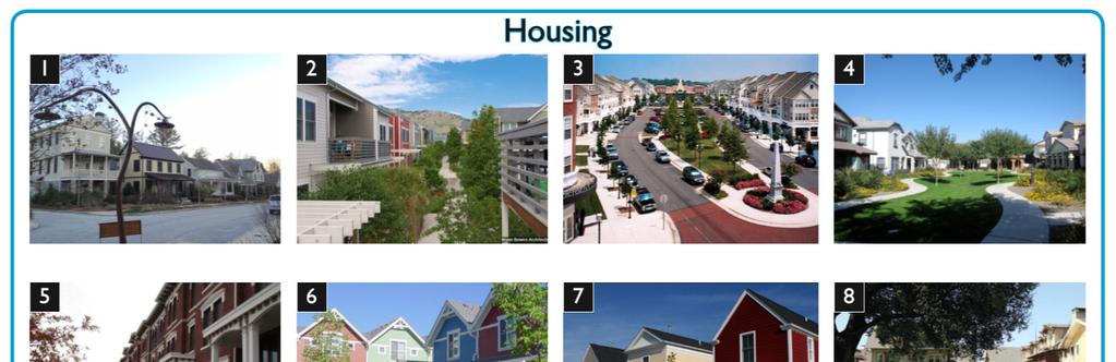
6 HOUSING Preference Board


7 HOUSING Top Choices 9 35% 4 15% 10 14% 3 9% 8 5% Picture ID % 4% Bottom Choices 12 3% 5 3% 2 3% 1 3% 6 1% 0% 5% 10% 15% 20% 25% 30% 35% 40% n=117
8 HOUSING Top Choices A clear preference for Option 9 was established, with more than one-third (or 35 percent) of the Housing stickers placed on this image. When comparing differences between Option 9 and the bottom choices, it appears that a preference for lower density residential options and architectural design style may have played a role in this image being the preferred choice. Options 4 and 10, similar in that they are alley loaded homes with front doors opening to a shared green space, ranked second and third; together these two images received nearly one-third (or 29 percent) of the votes (i.e. Housing stickers). Noticeable similarities among the top three choices is a neutral color palette and ample green landscaping. Bottom choices tended to share in common a higher density character and architectural design styles not typical of El Paso. Despite its similar layout to Options 4 and 10 (both top choices), Option 6 received the fewest stickers. Factors influencing this variation may include a non-preference for attached housing and/or architectural style and character, such as color palette. Bottom Choices Option 3, which depicts a higher density, primarily residential neighborhood, came in a distant 4 th place (receiving one in ten votes). Although clearly not a choice preferred by most, its rank relative to other options suggests that density of this level may be appropriate in some places, such as a long a main street as depicted in this picture. Interestingly, a like for main streets was repeated in several other categories as the following pages of this report will show.
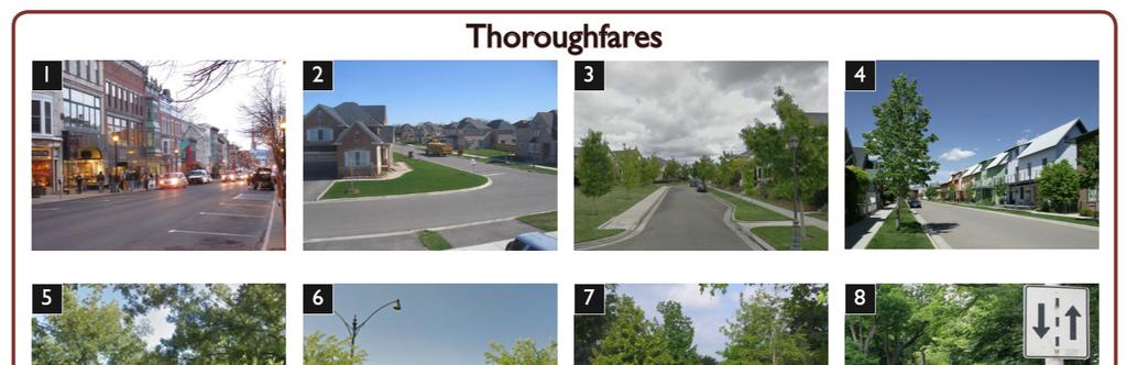
9 THOROUGHFARES Preference Board
10 THOROUGHFARES Top Choices 5 23% 1 18% 3 15% 7 11% 12 8% Picture ID 8 9 5% 8% Bottom Choices 6 5% 10 4% 4 3% 11 2% 2 1% n=120 0% 5% 10% 15% 20% 25%
11 THOROUGHFARES Top Choices A notable distinguishing factor between top and bottom selections is the presence of trees in images receiving the highest votes. This trend suggests that thoroughfares, whether rural or suburban in nature should include tree-lined streets. Receiving nearly one-fourth (or 23 percent) of votes, the top choice was Option 5, which depicts a rural two-lane road with soft shoulders and mature trees creating an arched canopy. The preference shown for this image suggests tree types that will take this shape over time and create a sense of enclosure should be planted along the new community s thoroughfares. A preference for main streets is again evidenced by the selection of Option 1 as the second choice (receiving 18 percent of votes); this image depicts a more urban thoroughfare with on-street parking that abuts a storefront-lined block. Option 3, a top choice, and Options 2, 4 and 11, all bottom choices, depict similar single-family residential streetscapes. Option 3 may have been singled out as a preference because of its more narrow pavement width and the prominent presence of sidewalks and trees. Bottom Choices A strong preference for tree-lined streets is repeated by the drastic difference in preference for Option 5 (receiving 23 percent of votes) and Option 11 (receiving 4 percent of votes). This difference serves to illustrate the importance of tree cover, as the two thoroughfares are otherwise essentially the same rural design.
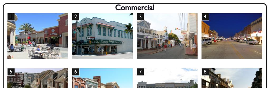
12 COMMERCIAL Preference Board

13 COMMERCIAL Top Choices 6 21% 1 19% 5 15% 3 10% 12 9% Picture ID 9 2 6% 8% Bottom Choices 11 3% 8 3% 10 3% 4 3% 7 1% n=115 0% 5% 10% 15% 20% 25%
14 COMMERCIAL Top Choices The preference for the inclusion of a main street is highlighted by the selection of Options 3, 5 and 6 as top choices, earning nearly half (or 46 percent) of all votes combined. When comparing main streets depicted in the top choices, each of the three options presents a different kind of main street experience with varying levels of density and formality. The top choice, Option 6 (with 21 percent of votes) represents a mid-point between the high density formal nature of Option 5 and the low density small-town feel of Option 3. Option 1 was the 2 nd most selected (with 19 percent of votes), suggesting that a shopping area that can double as open space is preferable. A liking for gathering spaces that include outdoor seating is a theme repeated throughout other categories of this survey. Option 5 was the 3 rd most selected (with 15 percent of votes) despite its higher density character, echoing results from the housing category that higher density may be acceptable, but only along main streets. Bottom Choices The two least selected options, 4 and 7 with three and one percent of votes respectively, are dominated by pavement, suggesting that commercial space should focus on the experience for the individual, not the street or parking lot. Again, concern regarding architectural style and character was repeated in open ended comments, suggesting that options 10 and 8 may have ranked poorly because the style of buildings depicted in these images is not consistent with the Upper Valley.


15 PARKS & OPEN SPACE Preference Board

16 PARKS & OPEN SPACE Top Choices 5 17% 6 16% 11 12% 3 11% 1 11% Picture ID % 7% Bottom Choices 7 5% 9 4% 4 4% 8 3% 10 3% 0% 5% 10% 15% 20% n=116
17 PARKS & OPEN SPACE Top Choices Of the seven categories, preferences within the Parks & Open Space group were least clearly defined, suggesting a lack of consensus regarding appropriate open spaces for a new community. Option 5 emerged as the top preference, while the similar Option 8 fell within the bottom four. Both images show public plazas, characteristic of many towns in the Southwest and Mexico. However, whereas Option 8 is hardscaped, Option 5 features green landscaping and mature trees, suggesting that not only is a central meeting area that reflects the character of the region important, but that it is equally important that this space be green. Options 6 and 9 depict farmland located in proximity to residential uses. The preference shown for Option 6 may suggest that any farm or agricultural use should be well integrated into a neighborhood. Participants may have seen Option 9 as the meshing of incompatible uses, or a poor execution of integration. Bottom Choices A third dichotomy exists between Options 3 and 4, both of which depict settings more typical of an urban park. Where they differ is that Option 3 illustrates an outdoor space well-defined by public art, a trail and landscaping, while Option 4 lacks a sense of enclosure and definition. The idea of creating gathering areas appropriate for all, including children and families, is given preference in the selection of Option 11, which depicts a playground. Option 10 was the least selected option. The low rank of this image may be attributable to a feeling that desert landscaping and the Upper Valley are not compatible. Additionally, Option 10, much like Option 4, lacks a sense of enclosure and definition.

18 CIVIC BUILDINGS Preference Board

19 CIVICBUILDINGS Top Choices 7 20% 4 19% 2 16% 11 12% 10 11% Picture ID 9 10% Bottom Choices 8 5% 1 3% 5 2% 3 2% 6 1% n=101 0% 5% 10% 15% 20% 25%
20 CIVICBUILDINGS Top Choices Civic Buildings may include any number of buildings open for public use. Typical examples of civic buildings include town halls, schools and religious or government buildings. Over half (or 55 percent) of the total Civic Building selections identified Options 2, 4 or 7. Each of these images depicts a civic building that relates well to its surroundings and serves as a community focal point. When comparing top and bottom choices, it is clear that participants prefer civic buildings that are integrated into neighborhoods, rather than those that serve as stand-alone destinations. With regard to design, buildings showcasing modern architectural details were selected less often than the more traditional architectural types. Additionally, large expanses of paved area are not preferred, as illustrated by the low scoring Options 1, 3 and 6. This finding reinforces Commercial non-preferences where the two lowest ranking commercial images were also dominated by pavement. Bottom Choices
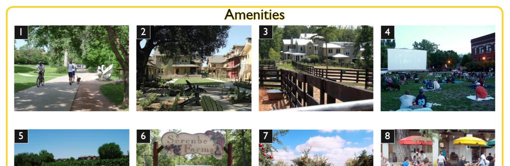
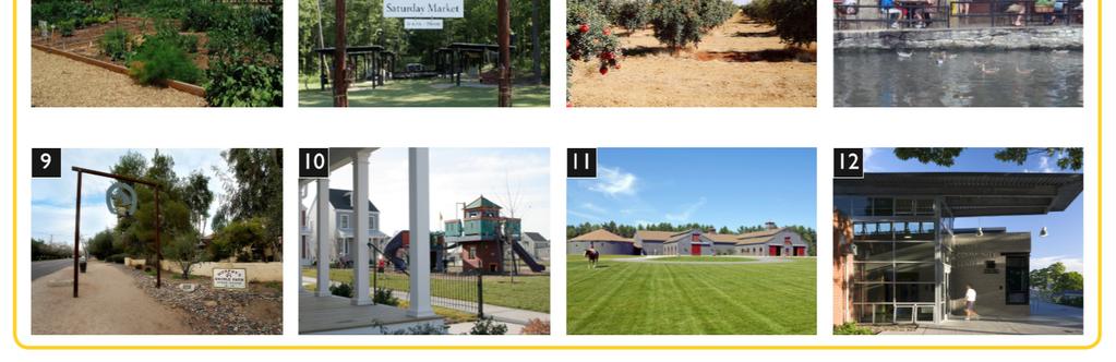
21 AMENITIES Preference Board

22 AMENITIES Top Choices 8 26% 6 22% 1 15% 4 12% 5 6% Picture ID % 4% Bottom Choices 10 3% 2 3% 7 2% 12 2% 3 1% 0% 5% 10% 15% 20% 25% 30% n=126
23 AMENITIES Top Choices With over one-fourth (or 26 percent) of selections, the outdoor seating space for a café/restaurant depicted in Option 8 was repeated as a high priority for participants. Notably, this selection also indicates that unique features, such as the water shown in this picture, ought to be used to augment the amenity. Option 6 scored closely behind top choice Option 8, receiving over one-fifth (or 22 percent) of votes. The high rank of this option suggests that a farmer s market or some other activity that relates to the heritage of the Upper Valley in a manner that is easily accessible by a wide audience should be an important feature of this new community. The preferred Options 1, 4 and 6 highlight spaces that provide opportunities for a variety of activities accessible to the entire community, whereas more open ended and specialized amenities, such as those shown in Options 3 and 7 (stables and an orchard), were less often identified as a preference. This trend is in line with previous findings that amenities and gathering spaces should be accessible to the entire community, rather than to typically smaller, more specialized interest groups. Bottom Choices Option 12, a recreational center, scored in the bottom two. Given previous findings, this relatively poor rank may have partially been influenced by the modern architectural design of the building rather than due to the amenities it offers.
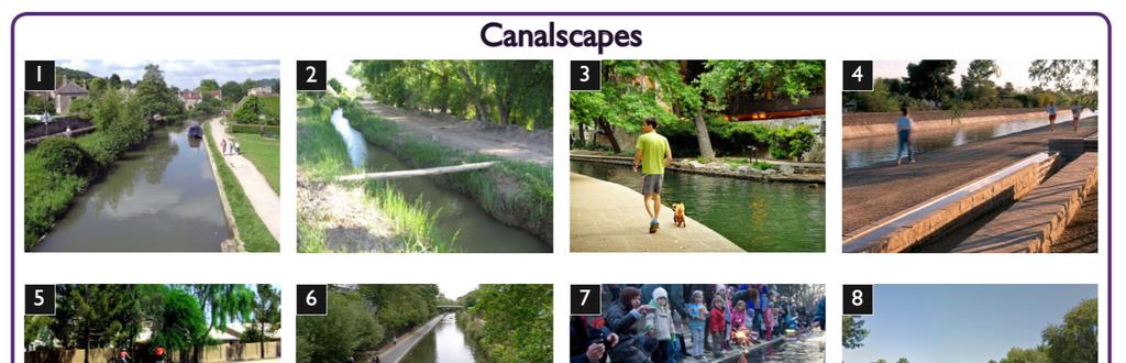
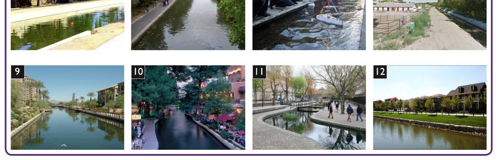
24 CANALSCAPES Preference Board

25 CANALSCAPES Top Choices 10 31% 3 19% 11 10% 2 8% 12 7% Picture ID 6 1 4% 7% Bottom Choices 9 4% 8 4% 4 4% 7 1% 5 1% n=137 0% 5% 10% 15% 20% 25% 30% 35%
26 CANALSCAPES Top Choices Well over half (or 60 percent) of votes indicated a preference for structured, urban canalscapes as illustrated by the top three choices: Options 3, 10 and 11. This finding suggests that canals should be a centerpiece of the development and serve as an amenity available for community-wide use. The top choice, Option 10, received the largest share of votes, representing nearly one-third (or 31 percent) of canalscape stickers. The trees and sidewalk, in combination with outdoor café/restaurant space and shallow building setbacks, create a sense of enclosure reminiscent of an outdoor room. The strong preference for this image augments previous findings suggesting that engaging outdoor gathering spaces should be a priority as design of the new community is considered. Bottom choices, Options 4 and 5 depict canalscapes improved for use as trails. Although both images include people using the trails, a reason for their low rank may be the sense of isolation they communicate relative to the top three choices. For example, Option 5 separates the canal from the rest of the community with a wall, while the presence of a surrounding community is missing from Option 4. Bottom Choices Interestingly, despite its structured urban nature Option 7 scored very low, receiving about one percent of votes. One factor that may have influenced the low score may have been an inability to relate the canal to the surrounding environment. Finally, despite their similar unimproved feel, Option 2 with eight percent of votes scored in the top four, while Option 8 with four percent of votes scored in the bottom four. The small difference in score may be related to a preference for more natural canalscapes that retain vegetation and have not been channelized using hard materials such as concrete.
27 COMMENTS ON VISUAL PREFERENCE SURVEY IMAGES A total of 51 comments were received regarding the various images shown during the visual preference survey. The largest share of positive comments received referred to a like for the trails and gathering spaces depicted in various images suggesting that the inclusion of such amenities should be a priority when designing the new community. The largest share of negative comments received referred to a dislike for the architectural style or character of an image. Many of these comments communicated a concern that the building style was not in keeping with the integrity of the region. Additionally, a review of negative comments received suggests that a community that finds a balance between a rural and urban character is preferred. The Housing and Thoroughfares categories received the largest proportion of comments, while the Amenities and Canalscapes categories followed closely behind. This finding suggests that these four categories are considered important elements of a new community and as such, should be given much attention in their design. The majority of comments received regarding Housing images were negative, suggesting that an objective of future meetings should be to better understand residential preferences.
28 SUMMARY OF FINDINGS Images above represent top preferences in each category.
29 SUMMARY OF FINDINGS The perfect community has an architectural style that is consistent with the character and history of the Upper Valley. many and varied public gathering spaces farmer s markets, parks and other active event spaces. Places to sit and gather. I like that [this image] is not high density. Walkways close to the water. Outdoor cafés are great Open Space for families and neighborhoods to gather. Looks most like El Paso Trees, trees and more trees! a main street where commercial and higher density uses are focused. canals that are available for use by the entire community whether as trails or outdoor cafés/gathering areas. landscaped thoroughfares and open spaces, with an emphasis on the importance of trees in creating a sense of enclosure and well-defined space. lower density residential neighborhoods that include some kind of variety such as traditional single-family detached homes and less traditional patio homes. civic buildings that relate well to their surroundings and are well integrated into the community rather than separated, stand-alone buildings. a range of development types rural, single-family housing, commercial areas and gathering spaces.
30 UV120 Master Plan Findings

31 PLAN A Holiday Neighborhood Boulder, Colorado

32 PLAN B Palm Dreams Karachi Golf City, Pakistan

33 PLAN C Serenbe Chattahoochee Hills, Georgia

34 PLAN D Ridgewood Village Humboldt County, California

35 PLAN E Agritopia Gilbert, Arizona

36 PLAN F City Park Houston, Texas

37 MASTER PLANS Parks & Open Space Commercial Preference Summary by Category Housing 16% 20% 38% Stickers were used as a tool to identify specific elements of the master plans liked by charrette participants. As illustrated by the graph to the left, the elements identified as preferences could be catalogued into one of seven categories. Of the total 174 stickers placed, nearly two-fifths (or 38 percent) referenced a Parks and Open Space element, suggesting that participants feel these public spaces are important features of any community. The largest share of Parks and Open Space stickers were placed on the multi-use Holiday Community Park pictured in Plan A and the Multi-Use Trails linking the community to Open Space pictured in Plan D. One in five (or 20 percent) of total stickers were placed on Commercial elements of the master plans, suggesting that participants are receptive to Commercial uses being included in the new community. Category General Like 14% The Market pictured in Plan D and the Retail Center pictured in Plan E, both large anchor retail spaces, were most often selected within the Commercial category. This trend suggests that there is an area need for a larger commercial amenity such as a grocery store. Agricultural 6% Sixteen percent of all stickers cited some element of Housing within the master plans. Parking 4% Preferences within this category were more evenly split among many different types of primarily lower density housing types, including: senior housing, multi-family townhomes, cottage and single-family/classic homes. Civic Building 2% 0% 10% 20% 30% 40% Total Stickers Placed (%) Plan C, a semi-rural cluster development, garnered a notable share of votes, although the specific plan element referenced by these votes was unclear; as a result, these votes have been classified as a General Like (note that the entirety of this category is comprised of votes for Plan C). n=174

38 MASTER PLANS Plan D Preference Summary by Master Plan 30% A total of 174 stickers were placed on the six Master Plans provided. The graph to the left illustrates the sticker spread among plans. Elements of Plans D and E were most often selected as preferred, with the plans receiving 30 and 29 percent of votes, respectively. Plan E 29% Plan D was cited most often for its Parks and Open Space, Housing and Commercial elements. Specifically, its multiuse trails and anchor retail market scored high, while housing choices indicated a preference for a variety of options appropriate for a wide range of age groups and income levels. Master Plan Plan A Plan C 17% 22% Plan E, on the other hand, was recognized most often for its Commercial and Parks and Open Space elements; other than the retail center, no single element stood out as preferred over others, suggesting that a variety of commercial and parks and open space types ought to be included in the new community. Plan B 2% Plan F 0% 0% 5% 10% 15% 20% 25% 30% 35% Total Stickers Placed (%) Plan A and Plan C received 22 and 17 percent of selections, respectively. Over two-thirds of selections for Plan A cited the Holiday Community Park as a preference, while the overwhelming majority of selections for Plan C cited a general like for the plan rather than identifying specific elements of its layout. Plan B received only two percent of stickers, while Plan F received none, suggesting that avant-garde and standard conventional developments are not preferred design alternatives. n=174
39 COMMENTS ON MASTER PLANS A total of 30 comments were received providing additional insight into specific likes and dislikes regarding the six master plans. Two-thirds of the comments received were positive. Of these, some element of open space or mixed-use was most often cited as a positive asset to the community. Specifically, community trails and adequate landscaping were repeated likes, while neighborhood mixed-use was a common theme. Plan C, a semi-rural cluster land development, received the largest share of comments relative to the other plans, all of which were positive in nature. Comments regarding Plan C cited a number of its elements, including its open spaces, mixed-use qualities and other features. With regard to negative comments, the density level depicted by several of the plans was of concern. This, in combination with a communicated like for neighborhood mixed-use, indicates that while there may be room for a range of uses including commercial, residential and office space, those uses should respect the lower density nature of the surrounding Upper Valley area.
40 SUMMARY OF FINDINGS Repeated themes include parks and open space are important elements of any community. Specifically, multi-use spaces that serve as gathering spaces for the entire neighborhood are a high priority, as are multi-use trails that serve as linkages throughout the community. neighborhood mixed-use is an amenity. In addition to small restaurants and cafés, there is a communicated need for a larger anchor retail/market space; however, that space should be integrated into the community, blending well with its surroundings. a variety of housing options are needed. A need for housing types that fit all age groups and income levels was communicated, although such housing should respect the lower density nature of the Upper Valley, including options like townhomes, cottage/patio homes, single-family detached homes and the opportunity for senior housing. the unique rural character of the Upper Valley should be maintained. Although traditional agricultural uses were not often cited as a preferences, comments and master plan selections consistently communicated a fondness for semi-rural communities. Amenities accessible to a wider audience such as community gardens may be explored as a way to preserve the character of the area.
41 UV120 Open-Ended Comments
42 OPEN-ENDED COMMENTS Maintain the unique farmland feel. Senior Housing. Restaurants and cafés. Riverwalk great idea. Nice multi-family, townhomes, duplexes. Maintain rural atmosphere. Make it unique, not a copy of another city. Repeated themes include the character of the community should stay true to the rural heritage of the Upper Valley, as well as the architectural design styles typical of the region. a mix of lower density housing options appropriate for all age groups and life stages should be provided. neighborhood mixed use such as cafés and restaurants are an amenity. establish and augment the existing canal as a community focal point. ensure that amenities, both traditional and non-traditional in nature be included in the design and plan of the community. n=14
43 UV120 Next Steps
44 CONCLUSIONS Repeated themes include the character of the community should stay true to the rural heritage of the Upper Valley, as well as the architectural design styles typical of the region. a mix of lower density housing options appropriate for all age groups and life stages should be provided. Explore Further How to best preserve the agricultural heritage of the Upper Valley through community design? Residential densities, styles and color palettes. Commercial and Main Street densities and styles. A range of thoroughfare types from rural to main street urban. important community buildings such as schools or anchor retail spaces should be well-integrated into their surroundings and add to the character of the neighborhood. parks and gathering spaces, both traditional and nontraditional in nature are important features of any neighborhood and should be designed in such a way as to encourage use by the entire community. neighborhood mixed use such as cafés and restaurants are a desired amenity. establish and augment the existing canal as a community focal point. green landscaping should be used as a way to define outdoor spaces and create a sense of place whether along thoroughfares, canals or in parks and other gathering spaces.
45 NEXT STEPS Report the findings of the January 30 th UV120 Public Meeting and Design Charrette to the community. Hold a second public meeting and design charrette to clarify remaining issues such as residential and commercial building styles and densities. Tentatively scheduled for Thursday, April 3 rd, Compile results from both meetings and begin working with design professionals to develop a plan for the new community that uses public feedback as its foundation and guide. Present the plan to the community and provide the opportunity for public comment, suggestions, additions, deletions, etc. Refine the plan given community feedback, hold a fourth public meeting if necessary, and finally, begin the development process.
46 ELIZABETH GIBSON HARRISON PLOURDE For Questions
B L A C K D I A M O N D D E S I G N G U I D E L I N E S for Multi-family Development
 B L A C K D I A M O N D D E S I G N G U I D E L I N E S for Multi-family Development Adopted June 18, 2009 This section of the Design and focuses on site planning and design guidance for new multi-family
Lehigh Acres Land Development Regulations Community Planning Project
 Lehigh Acres Land Development Regulations Planning Effort Summary In July, 2010 Commissioner Frank Mann invited the Lehigh Acres community to start discussing how to achieve their recently adopted community
Port Lavaca Future Land Use
 Port Lavaca Future Land Use Introduction The City of Port Lavaca is beginning to see sustained growth, after many years of relative stable population. New single family homes, apartments, and businesses
Secondary Plan - Annexed Lands. Vision Workshop Summary March 14th 2011
 Secondary Plan - Annexed Lands Vision Workshop Summary March 14th 2011 i Table of Contents 1.0 Executive Summary 1 1.1 Priority Directions 1 1.2 A Vision for the Annexed Lands 2 2.0 Introduction 2 2.1
SUMMARY MEETING. The following is a compilation of voting results from all five visioning sessions.
 SUMMARY MEETING The following is a compilation of voting results from all five visioning sessions. WHO ARE YOU? The next 10 graphs show compiled demographic information about the participants at all 5
PUBLIC RIGHT-OF-WAY IN THIS CHAPTER PUBLIC REALM
 PUBLIC RIGHT-OF-WAY This section provides design guidelines for improvements in the public right-of-way. The public right-of-way refers to streets, sidewalks, non-vehicular thoroughfares, parks and greenways
Complete Neighbourhood Guidelines Review Tool
 Complete Neighbourhood Guidelines Review Tool Prepared By: City of Regina Planning Department October 2014 Page 1 of 14 Community Development Review Checklist for Secondary Plans and Concept Plans The
Neighborhood Districts
 NEIGHBORHOOD DISTRICTS SEVEN MAIN DISTRICTS Neighborhood Districts While the Development Plan provides a broad-scale overview of the neighborhood, this section focuses on uses and relationships at the
A. Background Summary of Existing Challenges and Potential Possibilities. 1. Summary of Existing Assets and Potential Opportunities
 A. Background 1 A Main Street Master Plan Study was performed and completed in October of 2007. The study was initiated to review current land uses and development patterns along Main Street, from Parrish
Metro. Activity Center Design Guidelines. Recommendations For Developing Focused, Mixed-Use Commercial/Residential Centers
 Metro Activity Center Design Guidelines Recommendations For Developing Focused, Mixed-Use Commercial/Residential Centers Metro Activity Centers What is a MAC? Legacy, the adopted guide for the future growth
In surveys, Dallas residents say what they want to change most
 NEIGHBORHOODS ELEMENT In surveys, Dallas residents say what they want to change most in the city is its appearance they want it to look beautiful, with trees and pedestrian-friendly neighborhoods. The
Westwind Developments Ltd. PIONEER LANDS AREA STRUCTURE PLAN - PROPOSED AMENDMENT
 FEBRUARY 2013 TABLE OF CONTENTS 1.0 BACKGROUND... 1 1.1 Amendment... 1 2.0 LOCATION & CONTEXT... 2 2.1 Land Ownership... 2 3.0 POLICY CONTEXT... 3 3.1 Municipal Development Plan... 3 3.2 Capital Region
Blood Alley Square/Trounce Alley Redesign
 June 216 Kick-Off Events Questionnaire and Engagement Summary Background The City of Vancouver is redesigning Blood Alley Square and Trounce Alley, important public spaces in the heart of Gastown, which
MEETING PURPOSE AND OVERVIEW
 MEETING PURPOSE AND OVERVIEW On February 23, 2012, the City of Elk Grove hosted the first of two community workshops related to the Southeast Policy Area. The workshop was held from 6:00 8:30 p.m. in the
ARLINGTON COUNTY, VIRGINIA
 ARLINGTON COUNTY, VIRGINIA County Board Agenda Item Meeting October 15, 2005 DATE: September 28, 2005 SUBJECT: Request to Advertise the adoption of the 2005 Clarendon Sector Plan C. M. RECOMMENDATION:
5.1 Site Plan Guidelines
 5. Community Core Guidelines Development of the Community Core will take place by plan of subdivision and site plan approval. It will occur in a phased manner that will reflect the timing of residential
This Review Is Divided Into Two Phases:
 Semiahmoo Town Centre Review The purpose of this review: To review the Semiahmoo Town Centre Concept Plan, originally approved in 1993, to ensure that this centre will continue to serve the needs of South
Policies and Code Intent Sections Related to Town Center
 Policies and Code Intent Sections Related to Town Center The Town Center Vision is scattered throughout the Comprehensive Plan, development code and the 1994 Town Center Plan. What follows are sections
PROPOSED REDEVELOPMENT OF THE GLEN ABBEY GOLF CLUB. STREETSCAPE DESIGN STUDY (excerpt from the Urban Design Brief) TOWN OF OAKVILLE.
 TOWN OF OAKVILLE.") PROPOSED REDEVELOPMENT OF THE GLEN ABBEY GOLF CLUB STREETSCAPE DESIGN STUDY (excerpt from the Urban Design Brief) TOWN OF OAKVILLE OCTOBER, 2016 for 2.4.2 STREETS Streets are the single largest component
PROPOSED REDEVELOPMENT OF THE GLEN ABBEY GOLF CLUB STREETSCAPE DESIGN STUDY (excerpt from the Urban Design Brief) TOWN OF OAKVILLE OCTOBER, 2016 for 2.4.2 STREETS Streets are the single largest component
Presentation of the Staff Draft. July 17, 2014 SSRVP Team, Area 3
 Presentation of the Staff Draft July 17, 2014 SSRVP Team, Area 3 Presentation Overview Introduction Plan Framework Plan Recommendations Implementation Next Steps and Request for Public Hearing on September
Mark-up of the effect of the proposed Bronte Village Growth Area OPA No.18 on the text of section 24, Bronte Village, of the Livable Oakville Plan
 Mark-up of the effect of the proposed Bronte Village Growth Area OPA No.18 on the text of section 24, Bronte Village, of the Livable Oakville Plan Notes: This document is provided for information purposes
ELK GROVE GENERAL PLAN VISION
 2-1 CHAPTER 2: 2-2 CREATING OUR The Community Vision for Elk Grove, expressed through a Vision Statement and a series of Supporting Principles, is a declaration of the kind of community that Elk Grove
The Cambie Corridor 2015 Fall workshop series. What we heard WORKSHOP OUTLINE
 The Cambie Corridor 2015 Fall workshop series W 16 AVE Area 5 CAMBIE CORRIDOR Phase 3 What we heard ovember 21, 2015, 9am-noon, 1:30-4:30pm Peretz Centre 89 Participants* WORKSHOP OUTLIE Introductions
New-Cast Mixed-use Development Proposal King Street West, Newcastle, Ontario
 URBAN DESIGN BRIEF New-Cast Mixed-use Development Proposal King Street West, Newcastle, Ontario TABLE OF CONTENTS: 1.0 Executive Summary 2.0 Creating Vibrant and Sustainable Urban Places: Excerpts from
Standards (R-3) Figure B-11: R-3 Residential Standards Exhibit
 Figure B-11: R-3 Residential Standards Exhibit") Avila Ranch Avila Ranch Specific Plan Development Standards High Medium Density - High Residential Density Residential Lot and Building Lot and Standards Building (R-3) Standards (R-3) EXAMPLES These sketches
Avila Ranch Avila Ranch Specific Plan Development Standards High Medium Density - High Residential Density Residential Lot and Building Lot and Standards Building (R-3) Standards (R-3) EXAMPLES These sketches
Planning Board Briefing
 Planning Board Briefing Why Now? The Sector Plan Implementation Chapter States: Before Stage 1 begins, the following must occur: Approval of the Sectional Map Amendment. Approval of the Greater Lyttonsville
Downtown Development District. Creative Class Market Research
 Downtown Development District. Creative Class Market Research Creative Class and Industries of the Mind What is the Creative Class? People who use creativity in their work Not limited to workers in traditional
LOW DENSITY RESIDENTIAL
 LOW DENSITY RESIDENTIAL Corner lots with coach houses to increase diversity, provide unity to the streetscape and increase eyes on the street. Garages and ancillary units accessed via rear lanes. Parking
2. Form and Character. 2.1 Introduction. 2.2 The Downtown Addition Plan. 2.1 Introduction
 2.1 Introduction 2.1 Introduction This section of the Specific Plan describes and illustrates the desired form, character and uses of the Downtown Addition and explains the underlying design principles.
E. RURAL COMMERCIAL/INDUSTRIAL PARK MODEL
 E. RURAL COMMERCIAL/INDUSTRIAL PARK MODEL 1. PURPOSE The purpose of the Rural Commerce/Industrial Park Model is to provide parameters within which a grouping of business buildings with parking, loading
South th E ast Communit ity Centre (SECC)
") South East Community Centre (SECC) 1 New Park Design & Community Centre Update Thursday, February 8, 2018 Public Open House Thank you for attending this Open House! The town and the Consulting Team will
South East Community Centre (SECC) 1 New Park Design & Community Centre Update Thursday, February 8, 2018 Public Open House Thank you for attending this Open House! The town and the Consulting Team will
City Council March 27, Parks, Recreation, and Trails Master Plan
 City Council March 27, 2018 Parks, Recreation, and Trails Master Plan Planning Process Develop Goals and Objectives Inventory of Areas and Facilities Needs Assessment And Identification Public Participation
Village Center Zoning. Town of Sutton, MA June 15, 2016
 Village Center Zoning Town of Sutton, MA June 15, 2016 Village Center Zoning Project Phase 1 was the development of the new Model Bylaw Phase 2 sought communities to work with to update existing or create
DRAFT PLAN PRESENTATION
 DRAFT PLAN PRESENTATION 1.23.2018 AGENDA Process Project Schedule Results from Visioning Workshop Draft Plan Highlights Concept Plans Feedback Next Steps PROJECT SCHEDULE KICK-OFF WORKSHOP August 29 th
What Does It Take To Create A Town Center?
 What Does It Take To Create A Town Center? Context, Design, and Process The Prince Frederick Master Plan Update 1 Background and Overview A Brief History of Town Centers in Calvert County 2 Background
SECTION TWO: Overall Design Guidelines
 SECTION TWO: Overall Design Guidelines This section provides overall design principles and guidelines for the Gardnerville Mixed-use Overlay. They provide criteria for mixed-use places consisting of residential,
4.0 Design Guidelines For The Village Centre. South fields Community Architectural Design Guidelines Town of Caledon
 4.0 Design Guidelines For The Village Centre 4.0 Design Guidelines for the Village Centre The Village Centre is the focal point of the entire South Fields Community and is designed as a traditional commercial
St. Kevin s Area Planning Collaborative
 Table of Contents page 2 EXECUTIVE SUMMARY 3 MISSION STATEMENT 4 NEIGHBORHOOD CONTEXT 6 STREET CHARACTER 7 SITE PARAMETERS 9 COMMUNITY CHARRETTE - VISIONING GROUP TABLE 1 11 GROUP TABLE 2 12 GROUP TABLE
Town Center (part of the Comprehensive Plan)
") Town Center (part of the Comprehensive Plan) Mercer Island Town Center Looking North (2014) In 1994, a year-long process culminated in a set of design guidelines and code requirements for the Town Center
Town Center (part of the Comprehensive Plan) Mercer Island Town Center Looking North (2014) In 1994, a year-long process culminated in a set of design guidelines and code requirements for the Town Center
City of Farmington. Downtown Plan. Amendment to the 1998 Master Plan Adopted October 11, 2004
 City of Farmington Amendment to the 1998 Master Plan Adopted October 11, 2004 Introduction Planning Background 1 Scope and Components of the Plan Amendment 2 Concept Introduction 3 Plan Concepts 3 Conceptual
Plan Goals. Protect existing residential neighborhoods.
 Plan Goals Protect existing residential neighborhoods. Develop the vacant areas to the highest potential, in a quality manner, to provide an increase in tax base and services for residents. Provide pathways
RESEDA - WEST VAN NUYS COMMUNITY PLAN
 RESEDA - WEST VAN NUYS COMMUNITY PLAN Executive Summary As part of the initial outreach effort, the Department of City Planning hosted two workshops for the Reseda-West Van Nuys Community Plan Area during
Section 9 NEIGHBORHOOD DESIGN
 Section 9 NEIGHBORHOOD DESIGN City of Lancaster Comprehensive Plan D u n k i n, S e f k o & A s s o c i a t e s, I n c. NEIGHBORHOOD DESIGN INTRODUCTION There are many ways in which a neighborhood can
Workshop 3. City of Burlington Waterfront Hotel Planning Study. September 14, The Planning Partnership
 Workshop 3 City of Burlington Waterfront Hotel Planning Study September 14, 2017 The Planning Partnership The Waterfront Hotel Planning Study 01 The Brant & Lakeshore Planning Study will establish a Strategic
Town of Peru Comprehensive Plan Executive Summary
 Town of Peru Comprehensive Plan Executive Communities that plan grow by choice, not by chance. A plan makes growth thoughtful, understandable, and predictable. A plan shows that a community is managing
The Five Components of the McLoughlin Area Plan
 The Five Components of the McLoughlin Area Plan This documents contains the complete language of the five components of the McLoughlin Area Plan: The Vision Statement The Values The Guiding Principles
Prosperity Hucks Area Plan. Transportation and Planning Committee May 11, 2015
 Prosperity Hucks Area Plan Transportation and Planning Committee May 11, 2015 Presentation Outline 1. Background and Location 2. Community Dialog Process 3. Activity Center Recommendations 4. Wedge Recommendations
Urban Design Manual 2.0 DRIVE-THROUGH FACILITIES. Background. Urban Design Challenges
 222221 2.0 DRIVE-THROUGH FACILITIES Background In recent years, drive-through facilities have grown significantly in popularity with drive-through restaurants, in particular, being established on numerous
Ten Mile Creek Planning Area
 PLANNING AREA POLICIES TEN MILE CREEK Ten Mile Creek Planning Area Location and Context The Ten Mile Creek Planning Area ( Ten Mile Creek area ) is located south of the current Boise AOCI, generally south
WARM SPRINGS PARK MASTER PLAN
 TABLE OF CONTENTS page 1.0 Introduction and Overview 1 2.0 Information Gathering 2 3.0 Conceptual Alternative Development 8 4.0 Master Plan Development 14 5.0 Construction Cost Estimates 19 LIST OF FIGURES
Christine Vina VIA. Liz Trainor Highland Hills NA. Onofre Garza Calumet. Joanie Barborak Bond Initiative
 MEETING SUMMARY Meeting: Brooks Area Planning Team Meeting #8 Date: Thursday, April 12, 2018 Time: Location: Attendees: 4:00 pm 6:00 pm McCreless Library Jesse Pacheco South Central Alliance of Neighborhoods
Further input invited as Colchester Growth Strategy nears final phase
 IUE 3 / NOVEMBER 2015 Further input invited as Colchester Growth trategy nears final phase trathcona County is seeking public feedback as it enters the final phase of work on a Growth Management trategy
Mariposa Lakes. Planned Community. Project Overview. Stockton, CA
 Planned Community Stockton, CA Project Overview March 2007 Summary of Proposed Community is a master-planned community proposed for development on approximately 3,810 acres in southeast Stockton. In 2004,
East Bayshore Road Neighbourhood
 East Bayshore Road Neighbourhood Northridge Property Management Urban Design Brief 3195 East Bayshore Road City of Owen Sound January 2016 East Bayshore Road Neighbourhood Northridge Property Management
Welcome! to Keller Town Hall
 Welcome! to Keller Town Hall Keller Town Center Planning a New Downtown What is Keller Town Center? A new, growing downtown district planned as an urban village A combination of retail and office spaces,
Small Area Plan. South Gateway
 Small Area Plan Adopted May 12, 2008 South Gateway Purpose. The South Gateway Small Area Plan defines the City s expectations for the future of the southern entrance to the City at Interstate 85 and Highway
Creating Complete Roadway Corridors:
 Creating Complete Roadway Corridors: The AASHTO Guide to Transportation Landscape Architecture and Environmental Design NCHRP Project 15-33 Status Report AASHTO Standing Committee on Design Technical Committee
Dyersville Downtown Plan. Open House October 24, 2017
 Dyersville Downtown Plan Open House October 24, 2017 What is a Comprehensive Plan? - Vision - Guidance for decisions - Basis for regulations What is a Downtown Plan? - Understand priorities - Identify
Town Center. Block 5 Existing multifamily residential units are expected to remain.
 Area Guidelines Germantown s districts should be developed as distinct communities with unique features that are supported through the guidelines. The guidelines not only help distinguish these districts
Supplemental Design Guidelines
 Supplemental Design Guidelines 65 SUPPLEMENTAL DESIGN GUIDELINES As a supplemental reference to the project, the following diagrams are included to illustrate the site planning approaches that were followed
chapter DESIGN GUIDELINES NEW RIVER MASTER PLAN REPORT
 chapter DESIGN GUIDELINES NEW RIVER MASTER PLAN REPORT .76 DESIGN GUIDELINES An Overview design guidelines NEW RIVER MASTER PLAN Design Guidelines can transform the image of a city. Specific, design-based
Bourne Downtown Site Planning
 Prepared for: The Town of Bourne, MA In Cooperation with: Bourne Financial Development Corporation Prepared by:, Inc. June 24, 2009 Table of Contents Introduction and Summary... 1 Site Existing Conditions...
What Pioneer Grove Will Look Like?
 The City of Deerfield Beach has embarked on a journey to create a new town center within the old heart of Deerfield Beach. The new town center is known as Pioneer Grove. Pioneer Grove will be Everybody
Laberge Group. Town of Coeymans. Draft Comprehensive Plan. Overview of Planning Process
 Draft : Presentation of Goals & Strategies Laberge Group Benjamin H. Syden, A.I.C.P., E.D.P Director in Charge Nicole Allen, A.I.C.P. Senior Planner Anjali Malhotra Planner Presentation Outline Introductions
Don Mills Crossing Study and Celestica Lands Development Application Community Meeting, Open House, and Breakout Discussions
 Consultation Summary Don Mills Crossing Study and Celestica Lands Development Application Community Meeting, Open House, and Breakout Discussions This report is not intended to provide a verbatim transcript
7Page 91 CLEMMONS COMMUNITY COMPASS 7 COMMUNITY CHARACTER
 7 Community Character The beauty of Clemmons won t necessarily be a reflection of our past, but our future. This quote from Comprehensive Plan Steering Committee member Wayne Dodson captures the essence
CITY OF FARGO PARKING RAMP SITE EVALUATION
 CITY OF FARGO PARKING RAMP SITE EVALUATION EXECUTIVE SUMMARY Helenske Design Group (architect) and Carl Walker Inc (Parking Consultant) were retained by the City of Fargo to complete a downtown parking
Site Planning. 1.0 Site Context. 2.0 Pedestrian Circulation Systems. Pag e 2-23
 The following photographs from throughout the country illustrate key urban design principles. Photographs are provided to illustrate the overall urban design concepts described in Chapter 1 of the Downtown
3.1 community vision. 3.3 required plan elements
 Chapter 3 Community Form 3.1 community vision 3.2 Parks & landscaping concepts 3.3 required plan elements D R A F T 20 Community Form Chapter 3 3.0 Community form 3.1 community vision The Specific Plan
Exhibit Planning and Design Workshop February 3-6, Commissioned by the Maryland-National Capital Park and Planning Commission (M-NCPPC)
") Exhibit Planning and Design Workshop February 3-6, 2014 Commissioned by the Maryland-National Capital Park and Planning Commission (M-NCPPC) Planning and Design Workshop The Montgomery County Planning
Exhibit Planning and Design Workshop February 3-6, 2014 Commissioned by the Maryland-National Capital Park and Planning Commission (M-NCPPC) Planning and Design Workshop The Montgomery County Planning
Meeting Notes. Meeting Date: Feb. 28, Re: Public Meeting #2 Cornerstone Baptist Church Date Issued: February 29, 2012 Compiled By: Paul Thomas
 stream design, LLC 1535 grant st. ste 203 denver, co 80203 (p)720.663.7352 www.streamlanddesign.com Meeting Notes Project: Westwood Park Meeting Date: Feb. 28, 2012 Re: Public Meeting #2 Location: Cornerstone
Burnside Gorge Neighbourhood Plan. Engagement Summary
 Burnside Gorge Neighbourhood Plan Engagement Summary Table of Contents Engagement Summary... 3 Phase One Engagement (April May 2015)... 4 Phase Two Engagement (January March 2016)... 4 Appendix One: Summary
City of Le Sueur DOWNTOWN MASTER PLAN
 City of Le Sueur DOWNTOWN MASTER PLAN City Council Update 9/11/2017 Hoisington Koegler Group Inc. Presentation Agenda 01 Schedule Update / Tonight s Objectives 02 What We ve Heard - Engagement Comments
Urban Planning and Land Use
 Urban Planning and Land Use 701 North 7 th Street, Room 423 Phone: (913) 573-5750 Kansas City, Kansas 66101 Fax: (913) 573-5796 Email: planninginfo@wycokck.org www.wycokck.org/planning To: From: City Planning
Town of Cobourg Heritage Master Plan. Statutory Public Meeting
 Town of Cobourg Heritage Master Plan Statutory Public Meeting April 25 th 2016 Presentation Overview 1. Introduction 2. Project background and schedule overview 3. Review of strategic direction content
Official Plan Review: Draft Built Form Policies
 PG.30.1 REPORT FOR ACTION Official Plan Review: Draft Built Form Policies Date: May 15, 2018 To: Planning and Growth Management Committee From: Chief Planner and Executive Director, City Planning Division
Draft Cary Community Plan Review Part 3: Shop, Engage, Serve, Special Area Plans, Other Updates. October 27, 2015 Police Department Training Room
 Draft Cary Community Plan Review Part 3: Shop, Engage, Serve, Special Area Plans, Other Updates Committee for the Future October 27, 2015 Police Department Training Room AGENDA 1. Welcome and Call to Order
1120 Haist Street - Pelham Arena Community Co-Design Recommendation Report Haist Street - Pelham Arena Community Co-Design Recommendation Report
 1120 Haist Street - Pelham Arena Community Co-Design Executive Summary: In May, 2017 the Town retained the services of The Planning Partnership to undertake a community design charrette process to determine
WINDSOR GLEN DESIGN GUIDELINES
 WINDSOR GLEN DESIGN GUIDELINES Adopted by Council, 2006 WINDSOR GLEN REDEVELOPMENT DESIGN GUIDELINES August 2006 1.0 Master Plan Organization For this area of the Coquitlam Town Centre, a mix of high,
VISION, GOALS & CONCEPT DIAGRAM 2.0
 CHAPTER 2.0 2.1 Vision Creation Process 2.2 City Center Vision Statement, Goals and Objectives 2.3 Individual Zone Visions 2.4 Steps in City Building 2.5 Urban Form Concept Diagram for City Center VISION,
VILLAGE OF SKOKIE Design Guidelines for Mixed-Use Districts NX Neighborhood Mixed-Use TX Transit Mixed-Use CX Core Mixed-Use
 VILLAGE OF SKOKIE Design Guidelines for Mixed-Use Districts NX Neighborhood Mixed-Use TX Transit Mixed-Use CX Core Mixed-Use TABLE OF CONTENTS CHAPTER 1 SITE DESIGN Purpose 1 CHAPTER 2 SITE DESIGN Streetscape
A Neighborhood (Residential, Employment, or Mixed Use) has two components: a Center and a walkable area surrounding the Center.
 has two components: a Center and a walkable area surrounding the Center.") 6INFO SHEET There are two Place Types in the Neighborhood Model: Places organized around a Center, called Neighborhoods, and Places without a Center, called Districts. The Neighborhood Model focuses on
6INFO SHEET There are two Place Types in the Neighborhood Model: Places organized around a Center, called Neighborhoods, and Places without a Center, called Districts. The Neighborhood Model focuses on
Denton. A. Downtown Task Force
 2 Public Involvement Early and ongoing public involvement was solicited so that the public had ample opportunity to help direct the DTIP s concepts and implementation strategies. The residents of Denton
Behnke Ranch Property, Pasco County: Master Plan Development Approach
 February 24, 2014 , Pasco County: Master Plan Development Approach Location & Program The (Legacy PUD) is located in southwest Pasco County along State Road 54 approximately 1.5 miles west of the Suncoast
4. INDUSTRIAL 53 CASTLE ROCK DESIGN
 4. INDUSTRIAL 53 CASTLE ROCK DESIGN CASTLE ROCK DESIGN 54 4. INDUSTRIAL Overview Well-designed and attractive industrial centers are the product of blending economic realities with both functional and
REGIONAL ACTIVITY CENTER
 DRAFT REGIONAL ACTIVITY CENTER 70 EAST BENCH MASTER PLAN DRAFT 06 Introduction The East Bench Regional Activity center is comprised of large educational, research, medical, and employment centers. These
DRAFT ROOSEVELT ROAD. District Recommendations. Figure 5.23 The Roosevelt Road Corridor
 CHAPTER 5 Figure 5.23 The Road Corridor Road will develop as a mixed-use corridor, emphasizing regional retail, west of the river and mixed-use development east of the river. KEY RECOMMENDATIONS 1. High
Arkansas River Corridor
 Planning for Access Welcome to the Access Project. This project is a recreational planning effort in response to an interest by regional communities along the Arkansas River corridor. The project plan
Sahuarita District & Phase 1 Master Plan. Town Council December 11, 2017
 Sahuarita District & Phase 1 Master Plan Town Council December 11, 2017 Visioning Study Visioning Process Advisory Group Meetings Community Questionnaire Town Center Case Studies Community Analysis The
Everton s Neighbourhood Plan. Site Allocation - Assessment Criteria
 Everton s Neighbourhood Plan Site llocation - ssessment Criteria Introduction 1.1 This report assesses all the sites identified through the emerging Neighbourhood Plan for Everton and their potential for
Design Considerations
 Essential to the development of a successful Master Plan for the Park Complex is input from the community that the park will serve. The community outreach component of the planning process included numerous
Arlington, Virginia is a worldclass
 EXECUTIVE S U M M A RY Arlington maintains a rich variety of stable neighborhoods, quality schools and enlightened land use policies, and received the Environmental Protection Agency s highest award for
GUIDING PRINCIPLES IN THIS CHAPTER
 GUIDING PRINCIPLES The guiding principles and design concepts in this chapter work together with the Chapel Hill 2020 Comprehensive Plan to support new public places that can be enjoyed by all while also
General Manager, Planning and Development; General Manager, Parks, Recreation and Culture. Proposed Mini-Park and Plaza Designations
 Corporate NO: R106 Report COUNCIL DATE: June 16, 2008 REGULAR COUNCIL TO: Mayor & Council DATE: June 12, 2008 FROM: SUBJECT: General Manager, Planning and Development; General Manager, Parks, Recreation
SUBJECT: Waterfront Hotel Planning Study Update TO: Planning and Development Committee FROM: Department of City Building. Recommendation: Purpose:
 Page 1 of Report PB-23-18 SUBJECT: Waterfront Hotel Planning Study Update TO: Planning and Development Committee FROM: Department of City Building Report Number: PB-23-18 Wards Affected: 2 File Numbers:
hermitage town center
 hermitage town center A Community Vision prepared by Strada for The City of Hermitage and The Mercer County Regional Planning Commission January 2007 table of contents introduction 3 design principles
New York Avenue Streetscape and Trail Project Public Meeting #1 Summary
 New York Avenue Streetscape and Trail Project Public Meeting #1 Summary I. King Jordan Student Academic Center (SAC) Gallaudet University, Washington, DC February 23, 2017 Table of Contents 1.0 Introduction...
CITY OF BOYNTON BEACH SE 1 ST STREET COMPLETE STREETS IMPROVEMENTS
 CITY OF BOYNTON BEACH SE 1 ST STREET COMPLETE STREETS IMPROVEMENTS N Project Location -Town Square -Villages at Ocean SE 1st St, between E Woolbright Rd and SE 2nd Ave Project Location -Boynton One -Publix
C. Westerly Creek Village & The Montview Corridor
 C. Westerly Creek Village & The VISION Community Vision When the goals of the city are achieved Westerly Creek Village, a distinctive community defined by Montview Boulevard and Westerly Creek, is a strong
Wide asphalt driveway abutting school property. garage built with incompatible materials, too close to park. incompatible fencing materials
 Wide asphalt driveway abutting school property incompatible fencing materials garage built with incompatible materials, too close to park Lack of plantings as a buffer between private property and open