ARVADA BLUNN / PIONEER MASTER PLAN
|
|
|
- Oscar Bryan
- 6 years ago
- Views:
Transcription

1 ARVADA BLUNN / PIONEER MASTER PLAN PREPARED FOR THE CITY OF ARVADA, COLORADO SEPTEMBER 2015


2
3 Blunn / Pioneer Master Plan Committee Design Team Utilities Wenk Associates Sandra McDonald Jim Sullivan Cliff Deeds Larry Hack Project Manager Utilities Director Water Operations Water Treatment Nicole Horst Drew Button ERO Resources Principal Designer ERO Resources Parks, Golf, & Hospitality Moneka Worah Environmental Resource Specialist Mike Lee Jim Wilkins Darrell Linders Public Works Landscape Architect Golf Course Operations Parks WWE Engineering Ian Paton Wright Water Engineering Civil Engineer Mark Bowman Pat Dougherty Streets Engineering Community Development Carol Ibanez Senior Planner City Manager s Office Jessica Prosser Sustainability Arvada Police Department Lynn Johnson Deputy Police Chief Jefferson County Open Space Amy Ito Planning and Stewardship
4 project introduction executive summary existing recreation project timeline site analysis historic land use existing conditions opportunities & constraints area for development alternatives development natural resource evaluation highway 93 reservoir concept programs potential programs preliminary concepts public participation public meetings survey results public feedback master plan & recommendations appendix refi ned concept proximity map recommendations aerial perspective
5
6 Project Introduction Looking at the project area for the Blunn Pioneer Master Plan project, 1,600 acres of land in western Arvada are under consideration for the future development of the city. The available land will be used for transportation, water storage, recreation and conservation. Arvada residents and other visitors come here to fi sh at Blunn Reservoir, fl y model aircraft, go frisbee golfi ng, exercise their dog, or simply take in the great outdoors on an extensive trail network. Locals take great pride in the serene, natural character of the land surrounding Blunn Reservoir and Pioneer Sand and enjoy its close proximity to the foothills and abundant wildlife. The Ralston and Arvada Water Treatment Plants also located here, treat and distribute millions of gallons of drinking water for local customers each month. Nearly 600 acres of land remain available for new uses, or expansion and relocation of existing uses. Potential uses identifi ed for the site include completion of the Jefferson Parkway, installation of a reservoir, a bike park, a public shooting range, a community solar array, compost transfer station, police training facility, prairie dog preserve, and a model aircraft fi eld. Gravel mining on this site began in the 1980s and came to an end in 2013 when the city established a new agreement with Pioneer Sand Company Inc. (Pioneer). Reclamation of the land will be completed by Pioneer by 2017 and retail of landscape materials from a 20 acre sale yard will proceed as normal until Because the Pioneer land reclamation is beginning soon, a plan for the future can help the city effi ciently and appropriately move soil to prepare for future development of the Jefferson Parkway, the Highway 93 reservoir, and other planned uses. A master plan concept was developed in response to site ananlysis by Wenk Associates, feedback from the public, and advisement from the Blunn Pioneer Master Plan Committee. The committee included representatives from the utilities department, parks department, community development, sustainability, Arvada Police Department, and Jefferson County Open Space and met regularly as the master plan developed.

7

8 executive summary Site Location The project area is located in western Arvada at the base of the foothills. The land is characterized by its grassy slopes and fl at-top mesas typically seen along the Front Range as the prairie transitions into a montane landscape. Highway 93, 64th Avenue, Virgil Way, and Leyden Road border the 1,600 acres of land owned by the city. In terms of local and regional recreation areas, the project area is positioned to the east of White Ranch Open Space Park, to the north of North Table Mountain Park and Long Lake Ranch Park, and south of Leyden Rock Open Space that includes Pattridge Open Space. Project Goals The community around the Blunn/Pioneer land is growing quickly. In response to the population increase, Arvada needs a plan to meet the demand new residents will have for water usage, transportation, exposure to nature, and opportunities to recreate with their families and friends. Working with the committee and the community, a plan for the long-term future of the land purchased by Utilities for water storage was developed with current and future residents in mind. Programs for the site introduced during the project kickoff laid the framework for the rest of the plan. The future Jefferson Parkway and a reservoir capable of storing 3,000 acre feet of water are required land uses. Additional uses will promote community gathering, alternative energy use, outdoor recreation, and historical and ecological preservation. The Blunn/Pionner land will meet the water and transportation needs of the region, and simultaneously serve as a natural space refl ecting the interests and character of western Arvada s landscape and community. Product The result of the study is a refined master plan and set of recommendations for implementation as the city moves forward with development. The master plan developed over the course of several internal worksessions with the Blunn Pioneer Master Plan Committee (an internal stakeholder group), and two public meetings. The plan responds to input received from public outreach efforts made by the City of Arvada. Recommendations for each element of the master plan will guide the city s decision making in years to come. Programs are prioritized by available funding, support from the community, and coincidence with changes occuring on the site in the very near future. Programs that received both some support and resistance have been recommended for further study. 4 arvada blunn / pioneer - master plan report


9 refined concept HWY. 93 PROPOSED SIGNALIZED INTERSECTION 2 LEYDEN RD JEFFERSON PARKWAY EASEMENT * 14 HIGHWAY 93 RESERVOIR 13 PATTRIDGE OPEN SPACE * LEYDEN-BROOKES STONE CIRCLES OUTDOOR PUBLIC SHOOTING RANGE POLICE TRAINING FACILITY SOLAR ARRAY COMPOST TRANSFER SITE PRAIRIE DOG PRESERVE BIKE PARK ARVADA MODELERS AIRFIELD WESTWOODS GOLF COURSE EXPANSION ARVADA WEST DOG PARK BIRD S NEST DISC GOLF COURSE PROPOSED PARKING / TRAILHEAD 13 HIGHWAY 93 RESERVOIR 15 TUCKER LAKE STONE CIRCLES TRAIL UNDERPASS & TRAIL TO WHITE RANCH BLUNN PIONEER MASTER PLAN AREA BLUNN RESERVOIR TRAIL TO SPRING MESA NEIGHBORHOOD DOG PARK EXPANSION 64TH AVE VIRGIL WAY project introduction // 5 August 20, 2015

10 existing recreation Recreation Current recreational uses are concentrated at the northern and southern ends of the Blunn Pioneer Master Plan area. Pattridge Open Space, at the north end of the site, offers opportunities for equestrian riders and pedestrians alike to use soft surface trails for riding and running. The Arvada Associated Modelers model aircraft runway sits atop the mesa just south of Pattridge Open Space. Currently there is a control-line fl y circle, RC Car race track, small aircraft and large aircraft runway, as well as parking for visitors and club members. Arvada West Dog Park sits at south end of the Blunn Reservoir spillway along 64th Avenue Bird s Nest Disc Park, a popular frisbee golf destination, is located in the very southeastern corner of the project area and is bound on the north edge by Ralston Creek. Blunn Reservoir itself is often busy with fi sherman and small boaters. Trail access around the north side of the reservoir allows anglers to reach different fi shing spots. Ralston Creek Trail is accessible to users from Blunn Reservoir, adjacent residential areas to the east, Bird s Nest Disc Park and Long Lake Regional Park immediately to the south across 64th Avenue. HWY. 93 PROPOSED SIGNALIZED INTERSECTION BLUNN PIONEER MASTER PLAN AREA LEYDEN RD. 1 JEFFERSON PARKWAY EASEMENT 3 PATTRIDGE OPEN SPACE R.O.W. BLUNN RESERVOIR 4 64TH AVE STEEP SLOPES NATURAL AREAS ARVADA WEST DOG PARK BIRD S NEST DISC GOLF COURSE LEYDEN-BROOKES STONE CIRCLES ARVADA MODELERS EXISTING AIRFIELD RALSTON CREEK TRAIL BLUNN RESERVOIR PARKING / TRAILHEAD CLEAN FILL SITE WESTWOODS GOLF COURSE TUCKER LAKE VIRGIL WAY 6 Existing recreation mapping of the project area. 6 arvada blunn / pioneer - master plan report


11 2 4 Anticipated Changes to Existing Uses Arvada Associated Modelers Club. Fishing the pier at Blunn Reservoir. The existing easement for the Jefferson Parkway currently bisects the Modeler s existing runways and parking. In order to accommodate construction of the Parkway, the Arvada Modelers will have to move their fl ying facilities elsewhere within the site. Bird s Nest Disc Park is proposing to become a pay-as-you-throw course based on annual memberships. A small headquarters building or trailer on site would facilitate check-ins, and the sale of concessions and equipment. Money earned would be used to maintain and improve the course. Currently, the city uses a small area within the disc golf course as a clean fi ll site for excess dirt. It is not open to the public or any other types of dumping. The Arvada West Dog Park may expand into the south spillway of Blunn Reservoir. Enlarging the dog park would allow other areas of the existing park to close down in a rotating fashion for revegetation. Looking south across Bird s Nest Disc Golf course. project introduction // 7 August 20, 2015

12 project kickoff 3 / 9 site visit 3 / 24 3 / 2 2 / 25 contract with Wenk contract scoping meeting 1 / 20 committee meeting project timeline JANUARY 8 arvada blunn / pioneer - master plan report FEBRUARY MARCH initial committee meeting 12 / 2


13 presentation of master plan and recommendations city council workshop 7 / 27 APRIL MAY JUNE JULY project introduction // 9 August 20, 2015 concepts work session 4 / 23 5 / 6 website live with online feedback form 5 / 19 public meeting #1 5 / 28 survey sent to 500 randomly selected Arvada residents 6 / 23 public meeting #2 6 / 30 website input closes
14 Site Analysis The Blunn Pioneer Master Plan area carries a rich history of native american settlement, coal mining, railways, gravel mining, and more recently water treatment and outdoor recreation. A guided tour of the site led by employees of the city s Utilities Department, highlighted each of these valuable aspects. Today, the area attracts dog owners, frisbee golfers, cyclists, fi shermen, hobbyists, and abundant wildlife. Between the construction of Arvada s water storage infrastructure and Pioneer s mining operations, the project area has been heavily impacted. Despite its history of mining and construction, much of the area has been restored to a natural foothills prairie. In years to come, the master plan will aim to maintain the character of a restored prairie and refl ect the local way of life for residents past, present and future.

15


 12 64TH AVE.")
16 historic land use A Rich Background (above & below) As housing developments grow closer to the project area from the north and east, it is easy to see what the future holds for increased activity in the area. What is not as easy to see are the remnants of the past on the site. Matthew Prythero of the Arvada Historical Society provided an overview of the site s history. Leyden Mine Leyden Mine Leyden Brookes Stone Circles LEYDEN RD. Shaft 3 JEFFERSON PARKWAY EASEMENT PATTRIDGE OPEN SPACE RR Along Leyden Creek 1939 Old trolley line The Leyden coal mine, located in Leyden Gulch (between Highway 93 and the town of Leyden) was incorporated as the Leyden Coal Company in The Denver and Northwestern Railroad made tracks out to the mine to move coal from Leyden to Denver. Constructed with the development of the mine and the town of Leyden were several trolley lines for moving workers and residents as well as coal. Coal mining ended in the 1950s. The subterranean cavities were then used as natural gas storage, until recently when the city filled the cavities with water. The tramways, rail depot, and housing related to the mine are now almost entirely gone. PROPOSED SIGNALIZED INTERSECTION BLUNN PIONEER MASTER PLAN AREA HWY. 93 Arrowheads found in the 1930s BLUNN RESERVOIR TUCKER LAKE A school house was once located near the current Arvada West Dog Park. On the northern edge of the disc golf course, the foundation of the Blunn family home, and a silo remain today next to Ralston Creek. *To review the project s potential to effect known historic and cultural resources in the plan area, see appendix pages 9-10) 12 64TH AVE. CO Central RR Golden & Ralston RR Historical mapping of the project area. See an enlarged site map for the Leyden-Brookes Stone circles on page 13 Old School House site (destroyed) Rail Depot VIRGIL WAY arvada blunn / pioneer - master plan report


17 Coal mining settlement in Leyden Gulch. Mine shaft and facilities in Leyden Gulch. Trolley line along Leyden Creek. Leyden Brookes Stone Circles Located on the northwest edge of the mesa above Leyden Gulch is the historic site of the Leyden Brookes Stone Circles. In 2003, the area was investigated by the Colorado Historical Society, who identifi ed approximately 100 teepee rings. This collection of stone circles represents one of the largest Native American teepee rings in the metro area. Although the State of Colorado has no protection laws in effect for the teepee ring sites, the City of Arvada seeks to preserve the site. Leyden Brookes Stone Circles Site: Black dots on the map above represent Teepee Rings or former locations of Native American settlements. See the map on page 12 for its location within the Blunn Pioneer master plan area. site analysis // 13 August 20, 2015


18 existing conditions The Site Today Pioneer Sand & Gravel Upon the conclusion of the gravel mining operations at Pioneer in October of 2013, Arvada approved a lease with Pioneer that will end in Reclamation of the site must be completed by the end of The reclamation efforts include: Regrading slopes to be no greater than 3:1. Draining any standing water Establishing vegetation on disturbed soil Although mining has ended, retail of landscaping material will continue (until the conclusion of the lease in 2023) on a 20 acre sale yard. HWY. 93 PROPOSED SIGNALIZED INTERSECTION 3 LEYDEN RD. 0.5% 18% 1 1.5% 28% JEFFERSON PARKWAY EASEMENT PATTRIDGE OPEN SPACE 2 5% 15% 10% 15% STEEP SLOPES NATURAL AREAS PRAIRIE DOG PRESERVE 20 ACRE PIONEER S&G SALE YARD ( ) PIONEER MINING RECLAMATION ZONE XCEL ENERGY POWERLINE LEYDEN-BROOKES STONE CIRCLES ARVADA MODELERS EXISTING AIRFIELD ACCESS TO MODELERS AND PIONEER SAND Arvada Modelers & Prairie Dog Preserve The Prairie Dog Preserve shares land with the current fl y zone of the Arvada Modelers fl ying club. Bylaws of the club and standards set by the FAA require that no unprotected person or structure should be flown over. For this reason, these two uses are compatible for the time being. BLUNN PIONEER MASTER PLAN AREA 22% 8% BLUNN RESERVOIR TUCKER LAKE However, the prairie dogs have breached the boundaries of the preserve and are causing damage to the historic Leyden-Brookes Stone Circles site with the construction of their burrows. Prairie dog communities have spread to other areas of the site and in some instances are encroaching upon the backyards of residences in the Spring Mesa neighborhood. 64TH AVE. VIRGIL WAY 14 arvada blunn / pioneer - master plan report


19 3 2 Looking NE across the Pioneer Sand & Gravel Property Outlined in red in the image above is a bird s eye view of the Pioneer Sand & Gravel property and reclamation area. Outlined in blue is the 20 acre sale yard Pioneer will shrink to by the end of Sale operations at Pioneer Sand & Gravel site analysis // 15 August 20, 2015
 is the main facility operating year round, treating up to 36 million gallons per day.")


20 opportunities & constraints Utilities Water treament and conveyance infrastructure is heavily concentrated in the southern portion of the project area around Blunn Reservoir and Tucker Lake. The Ralston Water Treatment Plant (located between Blunn Reservoir and 64th Avenue) is the main facility operating year round, treating up to 36 million gallons per day. The Arvada Water Treatment Plant (located between Blunn Reservoir and Tucker Lake) only operates during peak flows (April-October) and can treat up to 16 million gallons per day. Water lines buried on site prevent there from being any opportunity for construction or tree planting nearby. HWY. 93 PROPOSED SIGNALIZED INTERSECTION LEYDEN RD. 2 JEFFERSON PARKWAY EASEMENT 3 PATTRIDGE OPEN SPACE STEEP SLOPES POWER LINE CELLULAR TOWER WATER STORAGE TANK TUCKER DITCH RALSTON WATER TREATMENT PLANT BLUNN RESERVOIR DAM EMBANKMENT ARVADA WATER TREATMENT PLANT SPILLWAY TUCKER LAKE DAM EMBANKMENT 9 Westwoods Golf Course uses water from Tucker Lake to irrigate turf. 4 TUCKER LAKE Stormwater passages include the spillways below Blunn Reservoir, Tucker Ditch, Ralston Creek, and Leyden Creek. High voltage power lines run north-south overhead through an Xcel Energy property between Pioneer Sand and the Spring Mesa neighborhood, and easements between Tucker Lake and Blunn Reservoir. Another electrical line runs west and northwest across the Pioneer property and provides power to their offi ces and areas further northwest. The overhead lines are infl uencing factors for the Arvada Modelers and appropriate fl y zones. BLUNN PIONEER MASTER PLAN AREA 5 BLUNN RESERVOIR 64TH AVE VIRGIL WAY 16 arvada blunn / pioneer - master plan report
 XCEL ENERGY POWERLINE PROPERTY WESTWOODS GOLF COURSE")

21 area for development HWY acres LEYDEN RD. JEFFERSON PARKWAY EASEMENT PATTRIDGE OPEN SPACE STEEP SLOPES SLOPE BREAK DEVELOPABLE LAND 20 ACRE PIONEER S&G SALE YARD ( ) XCEL ENERGY POWERLINE PROPERTY WESTWOODS GOLF COURSE EXPANSION Developable Land Utility easements, site topography, and future construction of the Highway 93 Reservoir and Jefferson Parkway impact the amount of developable land available on the site. Expected dates for construction of the Highway 93 Reservoir and Jefferson Parkway are not known at this time. However, construction is anticipated within the next years. PROPOSED SIGNALIZED INTERSECTION 450 acres 2 Developable land atop the mesa is confi ned to the fl at slopes on either side of the Jefferson Parkway easement (about 565 acres of available space). 115 acres of developable land lies west of the parkway easement, and 450 acres to the east. BLUNN PIONEER MASTER PLAN AREA BLUNN RESERVOIR TUCKER LAKE 18 acres 3 As part of the club house expansion project at Westwoods Golf Course, 18 acres of land between Virgil Way, Tucker Lake, and the Arvada Water Treatment Plant, has been designated for the addition of two more holes. Pattridge Open Space and Tucker Lake Open Space will remain as such.. 64TH AVE. VIRGIL WAY site analysis // 17 August 20, 2015
22 Alternatives Development Alternatives were developed that explored shifting existing and proposed uses around the available land to fi nd an ideal layout for future development. Changing ownership of the Pioneer land and planned development of Jefferson Parkway create moving parts within the project area that will displace existing access and programming. Opportunities for new uses (water storage, public recreation) will be created as the site changes in years to come.


23

24 natural resource evaluation ERO Resources *For the full version of this evaluation, see appendix pages 2-8) Land Use and Vegetation The study area is located at the base of the foothills and is characterized by open space with rolling topography. Blunn Reservoir, Tucker Lake, and infrastructure associated with the City s water supply occur in the southern half of the study area, and an existing gravel mine occurs in the northern section of the study area. Leyden Creek occurs in the northern section of the study area. Ralston Creek fl ows to Blunn Reservoir in the center of the study area and then exits the study area along the southeast corner. Wetlands and Other Waters of the U.S. ERO assessed the study area for potential isolated wetlands, jurisdictional wetlands, and other waters of the United States. Leyden Creek, Ralston Creek, tributaries to both drainages, Blunn Reservoir, and Tucker Lake occur within the study area. In the study area, Leyden Creek has a channel that varies from 3 to 5 feet wide, while Ralston Creek contains a 5 to 8 foot wide channel. Wetland vegetation is present in the study area along Leyden Creek, Ralston Creek, the tributaries to both drainages, Blunn Reservoir, Tucker Lake, and a few small drainages connecting the Blunn Reservoir on the southern bank. In addition, several patches of isolated wetlands occur in the northern section of the study area within areas that were part of the gravel mine. Leyden Creek, Ralston Creek, tributaries to both drainages, Blunn Reservoir, Tucker Lake, and wetlands associated with these features would likely be considered jurisdictional waters of the U.S. by the U.S. Army Corps of Engineers (Corps) because of their connection to known jurisdictional waters of the U.S., including the South Platte River. Any activities proposed within these areas would likely require a Section 404 permit under the Clean Water Act. ERO recommends conducting a wetland delineation if activities are proposed within any of these areas. The City submitted a jurisdictional determination request for the wetlands located within the gravel mine area. The Corps did not consider those wetlands to be waters of the U.S. because they are isolated from any known jurisdictional waters of the U.S. and were formed during gravel mining operations. 20 arvada blunn / pioneer - master plan report

25 natural resource evaluation Wildlife A black-tailed prairie dog colony occurs in the northern section of the study area. The colony has been designated as a 60 acre prairie dog refuge site by the City in the Arvada Prairie Dog Master Plan. The colony has expanded past the 60 acres that were previously designated and is currently closer to 150 acres in size. Black-tailed prairie dogs are commonly considered a keystone species because their activities (burrowing and intense grazing) provide food and shelter for many other grassland species, and have a large effect on community structure and ecosystem function (Power et al. 1996). Prairie dogs can contribute to overall landscape heterogeneity, affect nutrient cycling, and provide nest sites and shelter for wildlife (Whicker and Detling 1988). Species such as black-footed ferret, burrowing owl, prairie rattlesnake, and mountain plover are closely linked to prairie dog burrow systems for food and/or cover. Prairie dogs also provide an important prey resource for numerous predators including American badger, coyote, red fox, bald eagle, golden eagle, ferruginous hawk, and other raptors. The wetland and riparian vegetation in the study area provides abundant nesting habitat for a variety of raptors and songbirds. Grasslands within the study area are also potential nesting habitat for migratory birds, including ground-nesting birds. Waterfowl likely use Blunn Reservoir and Tucker Lake for foraging and loafi ng when the lakes are not frozen. Burrowing owls may be present within the prairie dog burrows in the northern section of the study area. To avoid destruction of potential ground-nesting migratory bird nests, vegetation should be removed outside of the April 1 through August 31 breeding season. The study area provides habitat for a variety of wildlife, inlcuding coyotes, mule deer, red foxes, raccoons, skunks, and various rodents. The drainages within the study area are likely used as a movement corridor for a variety of wildlife. Any wildlife using the drainages, wetlands, or riparian areas in the study area have likely become adapted to human disturbance due to the prevalence of urban and light-industrial development already surrounding the study area. alternatives development // 21 August 20, 2015
26 highway 93 reservoir concept Proposed Highway 93 Reservoir - Conceptual Siting Considerations Wright Water Engineers, Inc. The proposed Highway 93 Reservoir must store approximately 3000 acre-feet. The most suitable location for the new reservoir is the plateau to the north of the existing Blunn Reservoir. The natural grade of the plateau slopes downward to the east, with the steepest slope on the west side of the plateau. Construction of the reservoir will require excavation and construction of an embankment on the east side of the reservoir. Ideally, earthwork balance will be achieved by utilizing the excavation within the storage to construct the embankments. Siting options were evaluated in order to minimize excavation. Based on the criteria for storage requirements, for balancing cut and fi ll to the extent practicable, minimizing the necessary length of the embankment and reducing the surface area of the reservoir to the extent possible (to reduce future evaporative losses), options for potential sites were evaluated and roughly graded into the existing topography to identify the most suitable locations. Other criteria used as a basis for the preliminary grading included the following: Side slopes: 3H:1V Bottom slope 1 percent (toward east) Freeboard depth: 5 feet Dam crest width 30 feet Several potential sites were evaluated and ultimately the proposed location was selected based on the options which best met the site objectives. Characteristics of the proposed conceptual reservoir include the following approximate areas and elevations: Footprint area: 103 acres Pool area (at full capacity) 82 acres Maximum embankment height 62 feet Elevation (top of embankment) 5972 feet above mean sea level Elevation (bottom of pool) 5910 feet above mean sea level Maximum depth of excavation: 20 feet Maximum depth of fill embankment: 40 feet 22 arvada blunn / pioneer - master plan report

: depth to bedrock, depth to groundwater (including")


27 highway 93 reservoir concept An additional advantage of the selected site is its location upstream from a natural drainage channel, which runs to the northeast. In a condition where excess water needs to be drained from the reservoir, it could be routed down the existing drainage. In the future, as plans for the reservoir move from the conceptual planning stage to the design phase, the design will require the involvement of a qualifi ed geotechnical engineer and thorough geotechnical evaluation of the following (including, but not limited to): depth to bedrock, depth to groundwater (including seasonal variability), suitability of the fi ll material for the embankment, and suitability of the excavated material for use as lining material. The soils on top of the plateau are prone to leakage. In all likelihood, this factor will require installation of an impermeable liner. RESERVOIR EMBANKMENT 1 1 LEYDEN-BROOKES STONE CIRCLES OUTDOOR PUBLIC SHOOTING RANGE POLICE TRAINING FACILITY SOLAR ARRAY 5 PARKING AND TRAILHEAD 6 HIGHWAY 93 RESERVOIR PRAIRIE DOG PRESERVE 8 ARVADA MODELERS AIRFIELD 9 BIKE PARK 10 TRAILS / NATURAL BUFFER ZONE 11 TRAIL TO SPRING MESA NEIGHBORHOOD * See refi ned plan on page 5 for context alternatives development // 23 August 20, 2015


28 programs Water Storage The primary purpose of purchasing the land was to develop more water storage to accomodate Arvada s growing demand for water. The Highway 93 Reservoir proposed at the current Pioneer site would serve as an emergency reserve for Blunn Reservoir. LEYDEN RD. Prairie Dog Preserve The prairie dog preserve is one of only two refuge sites in Arvada. The 60 acre site is designated for prairie dog habitat and containment. Arvada Modelers The Arvada Associated Modelers are current users of the site. Their facility is open to the public for viewing and various events throughout the year. The facility includes runways for model planes and a remote control car course. HWY. 93 PROPOSED SIGNALIZED INTERSECTION PROPOSED RESERVOIR SIZE Jefferson Parkway As part of a plan to complete the Western Beltway, Jefferson Parkway will cut across the north eastern corner of the site. It is one segment of a plan to improve regional mobility and foster economic development. It will be four lanes wide and accompanied by a regional bike path. See the diagram on page 29 for more details. 64TH AVE. VIRGIL WAY 24 A previous study done by Applegate Group Inc. studied this site and drafted potential layouts for the reservoir prior to the creation of the Jefferson Parkway easement. See the proposed locations and sizes of the reservoirs in the map above. arvada blunn / pioneer - master plan report


29 programs Pictured here is the existing runway facility for the Arvada Modelers located on the northern edge of the mesa south of Leyden Rd. Pictured above is a proposed cross-section of the segment of the Western Beltway at Jefferson Parkway and Highway 93. alternatives development // 25 August 20, 2015


30 potential programs Historic Teepee Site Interpretative signage and a proposed park or monument would mark the historic settlement of large groups of Native Americans that once occupied the northwestern corner of the master plan area inside Pattridge Open Space. Trails / Equestrian Access New trails would connect Pattridge Open Space, trails around Arvada Blunn and Pattridge Park, Ralston Creek Trail, Tucker Lake, the future Jefferson Parkway trail, JeffCo trails via an underpass at Hwy 93, historical areas, and connections to different program uses. Compost Transfer Station A regional compost site would provide residents a place to take leaves, grass, and branches. It would also serve as a transfer station for restaurant organic material. Solar Array A 20-acre solar array would add electrical energy to the grid so residents could buy into solar power. Leyden-Brookes Stone Circles (teepee rings) Trails Compost Transfer Station Solar Array 26 arvada blunn / pioneer - master plan report


31 potential programs Police Training Facility The police training facility would be a regional governmental public saftety facility that includes an emergency vehicle operation course, indoor classrooms, simulators, and shooting range. There is the potential to share facilities with the public outdoor shooting range. Public Shooting Range An outdoor, professionally managed public shooting range would be located at a minimum of 1.3 miles from the nearest subdivision. Police Training Facility Public Shooting Range Golf Course Expansion Westwoods Golf Course may be adding two additional holes west of Virgil Way to accommodate planned expansion of the club house. The golf course expansion is part of a separate study underway by the city. Bike Park A bike park, like Valmont in Boulder, would contain hills and banks to ride off-trail bicycles. The trails would vary to provide interest for different skill levels. Bike Park Golf Course Expansion alternatives development // 27 August 20, 2015


32 preliminary concepts Spatial Analysis A series of spatial analysis diagrams were developed to determine an optimal layout that included all of the potential program elements. Initial concepts were created roughly with moving pieces much like a puzzle. Placement of each program element was dictated by requirements unique to the program as well as opportunities and constraints existing on the site today. The nine initial puzzle piece concepts experimented with space, relationships between adjacent programs, connectivity and proximity to easements and residential areas. The nine puzzle piece program layouts were then distilled into fi ve concepts. The five condensed concepts represent programs as different colored balloons representing spatial requirements for each element. Nine puzzle piece diagrams were used to analyze relationships between adjacent programs in terms of size, compatibility of use, and fulfi llment of other site specifi c requirements. This particular concept was determined undesirable for the adjacency of the teepee site and the prairie dog preserve as well as the close proximity of the police training facility to residences in Spring Mesa. 28 arvada blunn / pioneer - master plan report


33 preliminary concepts Reviewing Initial Concepts Five concepts similar to the one pictured left were presented at the committee worksession held April 23rd. Concepts varied in the amount of development required, the size of the reservoir, and east/west placement of the reservoir. After a review with the committee, each concept was determined desirable or undesirable based on the success of relationships between adjacent or over-lapping uses, and fulfi llment of each program s specifi c requirements. The above concept was determined desirable with revisions for the separation of the teepee site and the prairie dog preserve and the natural buffer between programming and the residences in Spring Mesa. Concept Refinement A single concept was drafted after the review with the committee. Further refinements were made to this concept in preparation for the fi rst public meeting. A consulation with leaders of the Arvada Modelers helped further identify an ideal placement for their runway/track facilities and fl y zones. Grading analysis was developed to portray a realistic size, shape and placement for the future Highway 93 Reservoir. This concept (pictured left) was presented at the fi rst public meeting. Changes that took place after the meeting included moving the solar fi eld away from housing, addition of trails and greenspace, and consolidation of the Arvada Modelers activity areas. The revised concept pictured here moved the modelers fl y area east of the parkway on request from the club leaders and shows expansion of the bike park into Pioneer Sand upon the end of the company s lease. alternatives development // 29 August 20, 2015
34 Public Participation The City of Arvada reached out to interested organizations and members of the surrounding communities to gather feedback in order to refi ne the design concepts. Representatives from the Arvada West Dog Park, the local equestrian community, the Arvada Associated Modelers, Bird s Nest Disc Golf, the Arvada Golf Advisory Committee, the Sustainibility Advisory Committee, and the Parks Advisory Committee contributed valuable information specifi c to their projects, properties and interests to the master plan committee in order to develop the refined concept. Over 350 comments were received online and over 200 survey replies from the community were received through a city-wide survey and a series of public meetings. Residents from Leyden, Spring Mesa, the Westwoods neigborhoods (and greater Arvada) were given the opportunity to voice their concerns and support for various aspects of the concept.

35
. Attendants were presented with the initial concept and proposed programs for the site.")


36 pubilc meetings Collecting Feedback from the Community Two public meetings were held to gather input on the design concepts and the proposed programming of the site. The first public meeting was held on May 19th at Ralston Valley High School (RVHS). Attendants were presented with the initial concept and proposed programs for the site. Comments and reactions were captured on comment cards and paper. An open forum began after the presentation where the audience expressed their desires and concerns for the proposed uses of the space. The second public meeting was held on June 23rd at Ralston Valley High School in an open-house format. The refined concept and next steps were displayed along with a video about the project. Stations were organized by key program elements. Visitors were invited to visit each station to give their feedback. At each station a knowledgeable representative for that program was available to answer questions and concerns. Feedback was collected on large sheets of butcher paper and through a dot survey to gauge concerns and support for each program. A large audience of more than 80 local residents turned out for Public Meeting #1 in the RVHS auditorium on May 19th. 32 Nicole Horst, Principal at Wenk Associates, presented the project to the public and the initial design concept. Local residents view design boards at the second public meeting held at Ralston Valley High School. arvada blunn / pioneer - master plan report

37 survey results Mail-In Survey: A survey was sent to 500 random water customers asking whether they would support, are neutral, or would not support the optional program elements for the site. Over 200 responses were received, which represents over a 40 percent response rate. Uses Don t Support Neutral Support Bike Park 12% 30% 58% Solar Array 20% 26% 54% Compost Transfer Site 14% 25% 64% Public Shooting Range 53% 10% 37% Teepee Site 19% 30% 51% Online Comments: Comments were received from primarily nearby residents who entered feedback on-line and at the fi rst public meeting. Only those who provided positive or negative comments were counted. If there was no comment, it was not counted. Over 350 comments were received. Uses Don t Support Support # of Comments Bike Park 8% 92% 52 Solar Array 54% 46% 50 Compost Transfer Site 17% 83% 12 Public Shooting Range 69% 31% 231 Spreading the News News of the design process for the Pioneer land spread quickly online through the City s website, social media, and nextdoor.com. Posts invited citizens to attend public meetings and/or provide feedback using the electronic feedback form on the webpage. Over approximately two months (from May 6 to June 26), the page received 5,359 views. Master plan info was included in the May edition of the Arvada News Electronic Newsletter. 1,800 people viewed the publication and nearly 100 followed the link to gain additional information. Teepee Site 0% 100% 4 public participation // 33 August 20, 2015

38 public feedback General Questions & Concerns 1. Question: It seems numerous special interest groups have been incorporated into this plan; how did they get preference over the land and its use? Are comments on this web site and upcoming June 23rd public meeting the only vehicles for the citizens to express their needs and wishes for the use of this land? Response: The City has received numerous requests from other agencies, private companies, the public and specialinterest groups throughout the years who would like to use this property. The Master Plan process was initiated due to the numerous requests being received. We tried to balance the needs of the citizens and the needs of the City. We decided there would be little to no privately held uses, and all uses should benefi t our residents. With the limitations in area, steep slopes, and other considerations, we agreed to move forward with the uses identifi ed. 2. Question: How is this plan integrated with the master development of the Candelas, Leyden Rock, and Leyden Ranch? How much Open Space remains in the City of Arvada if this plan moves forward and is implemented? Questions & Responses A sampling of comments, questions, and concerns received from the community through the different avenues of public outreach are summarized in the following pages. A complete record of feedback from the public is included in the appendix. Responses were developed to answer frequently asked questions and recurring concerns related to programs suggested in the master plan concepts. These responses were available at the second public meeting and on the project website. 34 Response: Large tracks of Open Space exist in the Leyden Rock, Leyden Ranch and Candelas developments.the City specifi cally reviews these plans based on the integration of open space areas and trails. Several miles oftrails will be generated by these projects. While the projects are reviewed and commented on separately they are all planned to connect to our City Park, Trail and Open Space system. Pattridge Park alone is over 300 acres of open space. The Blunn/Pioneer Master Plan will also be integrated into the city system including the new developments to the north, Long Lake Regional Park and the Van Bibber regional trail to the south, and the Ralston Creek state recreational trail. 3. Question: It seems to me there is very little land on the west side of Arvada that hasn t been developed and with the recent additions of Leyden Ranch, Leyden Rock, and Candelas, wouldn t it increase property values and add to the quality of life by leaving it as open space with a water storage facility and letting the existing Arvada Modelers stay? Response: Candelas alone has 5 neighborhood parks, 4 developed totaling 186 acres of open space in the residential area with 108 acres of open space planned through the proposed commercial areas. Leyden Rock has more than 600 acres of open space areas with another 100 acres in Leyden Ranch. The Arvada Comprehensive planning process bases ultimate populations on projected water supplies so there are signifi cant limits to development. Welton Reservoir is another 200+ acres of open space. The Leyden landfi ll area will also most likely be reclaimed and never be developed with preservation of the land and the unique rock formation that lies along Hwy. 93. arvada blunn / pioneer - master plan report

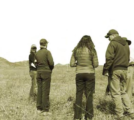
39 public feedback Water Storage & Jefferson Parkway Local residents are primarily concerned about noise and light pollution having an impact on the tranquility of western Arvada as a result of the construction of the parkway. Diffi culty of access to future programming and increased traffi c are also concerns. Residents asked how fl ooding, erosion, and natural drainage might be affected on the site as a result of building the Highway 93 Reservoir. People living adjacent to habitat areas that collect runoff worry that the natural character and water-dependent wildlife living there will go away. Questions & Concerns: 1. Question: Will the new water storage facility be open to the public? Will it be managed similar to the existing Blunn Reservoir (gated, fees to use, hours). Response: The Master Plan is looking at large scale conceptual designs. No detailed plans have been made as to how the 100+ acre water storage would be managed or secured. The Refi ned Concept shows simply a trail head for walking access to the area. 2. Question: Has anybody studied the effects of building the Highway Lakes reservoir and the current ground water? What impact will it have on Spring Mesa, the actual spring and the surrounding habitat? Will it dry up the ground water, bird habitat and water sources for the existing trees? Jim Sullivan (image left), Utilities Director at the City of Arvada, speaks with a local resident about water storage in the proposed HIghway 93 Reservoir and Jefferson Parkway. Response: The water storage reservoir covers less than 20% of the property on top of the mesa and will be engineered and constructed to minimize leakage. Its effect on ground water should be minimal; however, it has not been studied to date. 3. Question: Have any noise studies been conducted on the Jefferson Parkway? Any possibility of putting up a berm or some kind of noise barrier along the west edge of the Spring Mesa subdivision to mitigate noise from this entire development and the Parkway? Response: The Jefferson Parkway will comply with the City s noise ordinance. As part of the Parkway design, a sound analysis will be conducted and mitigation incorporated into the plan where needed. At this time a sound barrier along the west side of Spring Mesa has not been considered. However, it might be a consideration during the sound analysis and design of the Parkway. public participation // 35 August 20, 2015

40 public feedback Police Training Facility Supporters believe modern facilities and space for proper training are necessary for a strong police force. Concerned residents question the need for this facility as training is now being conducted elsewhere. The police training facility was requested by the Arvada Police Department with support of Jeffco Sheriff s Department. Questions & Concerns: 1. Question: Is there truly a necessity to consolidate the different types of police training into one facility? Does Arvada have to be its host? Why not the eastern plains? Response: There is a facility on the eastern plains that serves Adams County law enforcement. It is a training facility that offers firearms, driving, and defensive tactics training in one centralized location. The eastern location is diffi cult to share facilities with cities in the west region due to the distance and time required to get there. Law enforcement offi cers in the west region have to travel to multiple locations to receive the specialized training needed to succeed on the job. A consolidated facility provides the ability to offer state-of-the-art training in a more costeffective, centralized location. A new facility would provide the tools offi cers need to perform their jobs safely and effectively. Lynn Johnson (image left), Deputy Police Chief with the Arvada Police Department, speaks with a local resident about including a police training facility in the master plan. 2. Question: If the primary goal of the land is water storage, is a race track in compliance with these water storage and quality goals? 36 Response: The area needed for water storage is shown on the Refi ned Concept. This Master Study is being conducted to show how the remainder of the property could be used. The Emergency Vehicle Operations Course will be used for police training purposes only and is desired to assist our law enforcement personnel in receiving critical training without traveling great distances to do so. As with any development, water quality must be addressed at design. Because the training facility is located on the western side of the Jefferson Parkway, it will most likely not affect water storage. 3. Concern this use is too noisy for what is now a peaceful environment and neighborhood (lights and sound disturbance, etc) Response: The police training facility is located 1 mile from the neighborhood. It would not be immediately visible from any of the houses. Prior to a facility being designed, noise mitigation would be central to decisions on how the facility is built and would operate. arvada blunn / pioneer - master plan report
41 public feedback Outdoor Recreation & Natural Areas A majority of comments support trails, requesting that they be able to connect to other regional trail systems, open spaces, and parks. Issues include preventing confl ict of use between users on foot, bike, and horseback. Concern for the preservation of habitat and natural beauty of the site was a recurring concern received in the online comments. The prairie dog preserve did not appeal to some adjacent residents who worry about the destruction of vegetation prairie dog colonies cause. Questions & Concerns: 1. Question: In the development and expansion of additional facilities and holes at Westwoods Golf Course, will trails and habitat be protected and maintained for local users and wildlife? Bike Park Survey Results 12% 30% 58% don t support neutral support Response: The trail connection in this area will be relocated to the edge of the golf course and will provide a wildlife corridor with native vegetation. In fact, a large portion of the Ralston Creek Trail already shares space, and wildlife corridors, with the Westwoods Golf Course. 2. Question: Can there be more natural buffers and trail alignments through the proposed programs? Response: The current graphic plan is a concept diagram to identify the locations of proposed programs. There will be natural buffers and trails connecting the proposed programs. 3. Question: If the wetland areas are removed, where will the water go? Concerns that Park would attract crowds and produce dust. Most comments support the bike park. Minimized visual and traffi c impacts on the adjacent neighborhoods would be a priority. Teepee Rings Survey Results Response: Most of the wetlands that would be impacted were created as part of the mining operations. The historic drainage is in Moon Gulch, which will be restored with proper grading. The refi ned plan does include drainage improvements to the west of Spring Mesa to improve water quality, as well as an enhanced natural buffer between the site improvements and neighboring community. A majority of areas with wetlands and riparian habitat or other sensitive habitat will be protected. 19% 30% 51% don t support neutral support 4. Question: Why do we need the prairie dogs to stay/be preserved? Is there a Federal, State, or any other requirement to have a Prairie Dog Habitat? Response: There are no federal or state requirements for prairie dog preservation; however the City of Arvada did develop a prairie dog habitat plan that identifi ed this area as a prairie dog refuge site. Through the plan, the City recognized prairie dogs as an important fi xture of the local ecosystem and the importance of preservation of wildlife habitat within City open space. The habitat plan designates 60 acres at this site that is required to stay as a preserve. Fencing is planned to assist in managing the prairie dog preserve. Protection of stones from vandals and destruction of stone circles from existing prairie dogs. public participation // 37 August 20, 2015
42 pubilc feedback Outdoor Public Shooting Range Comments received indicate concern over disturbing western Arvada s peaceful character. Concerns are noise, safety, close proximity to residential housing and public use in natural areas. Supporters argue a publicly available range is needed and would benefi t the community. Shooting Range Survey Results The outdoor public shooting range was a request from Jefferson County Open Space with support of Jefferson County Public Shooting Range Working Group and Colorado Parks and Wildlife. Questions & Concerns: 1. Question: What will the noise impacts be? Will it be too noisy or close to the neighborhood? What types of sound buffering are possible? 38 Response: There will undoubtedly be some level of noise associated with an outdoor shooting range. Effective noise mitigation is possible. The National Shooting Sports Foundation (NSSF) elaborates on effective techniques including vegetation, berms, and barriers. A separate planning and design process, which will include opportunities for public involvement and comments, will be conducted for this facility. 2. Question: Why is a Public Shooting Range needed? Response: There is a demand for a safe, public, outdoor shooting range facility that safely and effi ciently serves the needs of a variety of shooters young and old, individuals and families, novice and experts. According to the Center for Disease Control & Prevention Behavioral Risk Factor Surveillance System Survey and the 2012 National Rifl e Association study, approximately 32% or 173,000 people own fi rearms in Jefferson County. Firearm safety would be a key focus of this facility. As such, there is an opportunity for education and training that would aide in reducing existing dispersed shooting areas scattered across Jefferson County. 3. Question: If the primary goal of the land is water storage, is a shooting range in compliance with these water storage and quality goals? Response: One of the primary goals of the property is to provide water storage. This use will require approximately 110 acres of land within the 1,600 acre master plan area. A public shooting range is considered a compatible public use. Best Management Practices developed by the National Rifl e Association (NRA) will be employed to address any environmental aspects with the planning and design of an outdoor shooting range facility. 53% 10% 37% don t support neutral support arvada blunn / pioneer - master plan report
43 public feedback Sustainability: Solar Array & Compost Transfer Station Neighbors were concerned that solar panels located close to homes could affect views, destroy wetland and prairie habitat, and produce sun refl ection. There was some interest in solar sharing. For the compost transfer station, comments were received about odor and waste being carried by the wind into eastern neighborhoods. Supporters say Arvada needs a drop site for landscaping materials. The request came from Arvada s Sustainability Coordinator with support of the Sustainability Advisory Committee. Questions & Concerns: 1. Question: Will solar arrays refl ect onto homes? Solar Array Survey Results 20% 26% 54% don t support neutral support Response: The chances of any glare from the solar panels effecting homes in the neighborhood is very low. Actually, it has been stated that solar panels refl ect less light than a white energy effi cient rooftop. Solar panel glare could occur when the sun is low in the sky. However, there are several design considerations that can reduce or eliminate the chances of solar panel glare reaching a home. Proper panel design and proper solar system design, such as using solar systems that track the sun, can virtually eliminate any chances of refl ected light reaching the neighborhood. In the refi ned plan, the proposed location of the solar array will be a mile from the nearest subdivision. 2. Question: What is driving the need for solar panels? Response: The community solar garden program with Xcel Energy was created to allow for residents and businesses to benefi t from solar without having to construct it on their roof or property. Someone with lots of trees or living in multi-family are good examples. The City would also like to have an allotment to power city facilities where we do not have enough roof area to offset power loads. Compost Transfer Station Survey Results 14% 25% 64% don t support neutral support 3. Question: Will the compost transfer site produce foul odors? Response: The compost site is proposed to be located one mile from the nearest subdivision. This site will be a transfer station where composting companies, landscapers and the public can bring food and yard waste for collection in large roll off dumpsters before it is transferred to a location about 30 miles east of Denver for processing. Processing of materials will not take place on site. Odors would be the same as a commercial dumpster. Any visual impacts will need to be accommodated through fencing or other design elements. The City would put out a Request for Proposal (RFP) for a company to manage the site. public participation // 39 August 20, 2015


44 other feedback The community provided a few additional program ideas for the site. These were considered by the city and a response was provided for each recommendation. Community Swimming Pool Several requests for a local community pool to serve the western side of Arvada. Response: A master plan was developed for the area by Apex Center that includes an outdoor pool. Refer to the Apex Park and Recreation District. ATV Areas Received a few comments regarding motorized vehicles. Response: There is not a large enough area on site to accommodate this use. There are too many potential confl icts with existing uses. Archery Range Request for Archery Range. Response: Refer to Parks Master Plan effort to assess need in futher detail. 40 arvada blunn / pioneer - master plan report
45 public participation // 41 August 20, 2015
46 Master Plan & Recommendations The Master Plan is an ideal confi guration of all the uses for the site. Recommendations regarding future development based on public feedback and worksessions with the committee accompany each program in the Master Plan (existing and proposed).


47
48 refined concept HWY. 93 PROPOSED SIGNALIZED INTERSECTION 2 LEYDEN RD JEFFERSON PARKWAY EASEMENT * 14 HIGHWAY 93 RESERVOIR 13 PATTRIDGE OPEN SPACE * LEYDEN-BROOKES STONE CIRCLES OUTDOOR PUBLIC SHOOTING RANGE POLICE TRAINING FACILITY SOLAR ARRAY COMPOST TRANSFER SITE PRAIRIE DOG PRESERVE BIKE PARK ARVADA MODELERS AIRFIELD WESTWOODS GOLF COURSE EXPANSION ARVADA WEST DOG PARK BIRD S NEST DISC GOLF COURSE PROPOSED PARKING / TRAILHEAD 13 HIGHWAY 93 RESERVOIR 15 TUCKER LAKE STONE CIRCLES TRAIL UNDERPASS & TRAIL TO WHITE RANCH BLUNN PIONEER MASTER PLAN AREA BLUNN RESERVOIR TRAIL TO SPRING MESA NEIGHBORHOOD DOG PARK EXPANSION 64TH AVE VIRGIL WAY 44 arvada blunn / pioneer - master plan report


 JEFFERSON PARKWAY :")


49 proximity map Open natural areas for trail use and wildlife habitat 2 HWY. 93 PROPOSED SIGNALIZED INTERSECTION BLUNN PIONEER MASTER PLAN AREA LEYDEN RD JEFFERSON PARKWAY EASEMENT * 12 HIGHWAY 93 RESERVOIR 13 PATTRIDGE OPEN SPACE 1.07 miles 1.3 miles * yds BLUNN RESERVOIR 64TH AVE TUCKER LAKE VIRGIL WAY Medium traffic areas for public recreation & utility Areas containing higher impact uses DISTANCES FROM NEAREST RESIDENCE MODELERS RUNWAY: 300 yds (3 football fields) BIKE PARK: 500 yds (5 football fields) JEFFERSON PARKWAY : 0.5 miles (at nearest) POLICE TRAINING: 1 mile SOLAR ARRAY: 1.07 miles PUBLIC SHOOTING RANGE: 1.3 miles miles 1 LEYDEN-BROOKES STONE CIRCLES 2 OUTDOOR PUBLIC SHOOTING RANGE POLICE TRAINING FACILITY SOLAR ARRAY COMPOST TRANSFER SITE PRAIRIE DOG PRESERVE BIKE PARK ARVADA MODELERS AIRFIELD WESTWOODS GOLF COURSE EXPANSION ARVADA WEST DOG PARK BIRD S NEST DISC GOLF COURSE PROPOSED PARKING / TRAILHEAD 13 HIGHWAY 93 RESERVOIR master plan & recommendations // 45 August 20, 2015
50 recommendations Next Steps The master plan committee arrived at four different recommendations for next steps for each of the programs included in the master plan. 1. Pioneer Reclamation Project During reclamation of the Pioneer Sand mining property, planned site grading can be done to set the stage for future development of these programs. 2. Arvada Parks Master Plan Although funding may not be currently available for development of these programs, they can be planned for and incorporated into the Arvada Parks Master Plan. 3. In-Progress Projects These programs can be funded and developed to prepare for or independently from future changes resulting from constructing Jefferson Parkway. 4. Further Study Needed Aspects of the design require further investigation and input from the community. Pioneer Reclamation Project Proceed with reclamation plan that is consistent with following proposed uses: Arvada Parks Master Plan Include as elements in the In-Progress Arvada Parks Master Plan update: In - Progress Projects Further Study needed before Conditional Land Approval Water Storage Relocation of the Arvada Modelers Bike Park Buffer Zone Area Trails Bike Park Expansion of Dog Park Disc Golf Course Operational Changes New Trails Leyden-Brookes Stone Circles - Teepee Rings *Conditional land approval would be included in the Parks Master Plan authorization West Woods Golf Course Improvements - Include in West Woods Clubhouse Master Plan development. Fencing the Prairie Dog Site - Proceed with budget for fencing prairie dogs. Solar Generation Center - Proceed with application/budget for grant funding. Composting Transfer Station - Proceed with budget and refi ned plan. Police Training Facility Public Outdoor Shooting Range *Require site specifi c concept plan and noise study; enter into interagency discussions and explore funding options for both programs. Pictured on the following page is an aerial perspective drawing that envisions the master plan looking southwest across the site from the western edge of the Spring Mesa neighborhood. 46 arvada blunn / pioneer - master plan report

51 aerial perspective SOLAR ARRAY JEFFERSON PARKWAY BLUNN RESERVOIR ARVADA MODELERS AIRFIELD HIGHWAY 93 RESERVOIR BIKE PARK MULTI-USE TRAIL WESTERN EDGE OF SPRING MESA NEIGHBORHOOD XCEL ENERGY POWERLINE EASEMENT master plan & recommendations // 47 August 20, 2015
52 Appendix Included are the following documents: Complete natural resource evaluation and historic properties report. Meeting summaries from worksessions held between the Blunn Pioneer Master Plan Committee and the design team, and public meetings. A complete record of public comments submitted online and received at the public meetings prior to July 1st, Table of Contents Natural Resource Evalutation - 2 Historic Properties - 9 Kickoff Meeting - 11 Worksession #2-15 Worksession #3-18 Worksession #4-21 Public Meeting #1-23 Worksession #5-27 Public Meeting #2-29 Blunn/Pioneer Master Plan Comments - 33 Noise Assessment & Recommendations - Blunn/Pioneer Master Plan to Spring Mesa Subdivision (Resident: Eric Jenkins) Letter from Concerned members of the community addressed to members of the Arvada City Council Letter from Don Gardner to City of Arvada: Master Planning Should Consider Archery - 113
53
RESPONSES TO PUBLIC CONCERNS AND QUESTIONS
 RESPONSES TO PUBLIC CONCERNS AND QUESTIONS Stations and Summary Questions for Public Meeting #2 June 23, 2015 General Questions / Concerns: 1. Is there any way this development can raise revenue for the
Policy & Procedure Effective Date: Parks Department Page of
 City of Arvada Policy & Procedure Effective Date: Parks Department Page of TITLE: City of Arvada Prairie Dog Habitat Plan APPROVAL: PURPOSE: To establish a plan for the preservation of black-tailed prairie
Yadkin River Greenway Feasibility Study Fact Sheet Village of Clemmons, Town of Lewisville, Town of Bermuda Run
 Fact Sheet Village of Clemmons, Town of Lewisville, Town of Bermuda Run Project Background The Yadkin River Greenway Feasibility Study is a joint project with the Village of Clemmons, the Town of Bermuda
CHAPTER 7: Transportation, Mobility and Circulation
 AGLE AREA COMMUNITY Plan CHAPTER 7 CHAPTER 7: Transportation, Mobility and Circulation Transportation, Mobility and Circulation The purpose of the Transportation, Mobility and Circulation Chapter is to
2011 ASLA Design Awards. Coyote Gulch Honor Award and Land Stewardship Designation Valerian LLC. Environmental Restoration and Reclamation
 2011 ASLA Design Awards Honor Award and Land Stewardship Designation Valerian LLC Environmental Restoration and Reclamation Project Name: Category : Project Location: 5 2011 Environmental Restoration and
Las Colonias Park Master Plan
 2013 Las Colonias Park Master Plan City of Grand Junction June 2013 Introduction Las Colonias Park, a 101 acre parcel on the edge of the Colorado River south of downtown, was deeded to the City of Grand
Chapter 5: Natural Resources and Environment
 NATURAL RESOURCES AND ENVIRONMENT 5-1 5 Chapter 5: Natural Resources and Environment BACKGROUND AND INTENT Urban expansion represents the greatest risk for the future degradation of existing natural areas,
1. Executive Summary. SECTION 1 Executive Summary. City of Arlington Lake Arlington Master Plan
 1. In December 2009, the engaged the environmental engineering and science consulting fi rm of Malcolm Pirnie to assist the City in developing a master plan for Lake Arlington (the Project ). Over a period
4.1 AESTHETICS AND VISUAL QUALITY
 SCOPE AND METHODOLOGY 4.1 AESTHETICS AND VISUAL QUALITY This section evaluates the potential impacts to aesthetics and visual quality. Aesthetics refers to visual resources and the quality of what can
Lewisville Lake Master Plan Revision Public Information Meeting May 2 & 4, 2017
 Lewisville Lake Master Plan Revision Public Information Meeting May 2 & 4, 2017 Presented By Rob Jordan Lake Manager U.S. Army Corps of Engineers Fort Worth District US Army Corps of Engineers Purpose
3. VISION AND GOALS. Vision Statement. Goals, Objectives and Policies
 Vision Statement Queen Creek s interconnected network of parks, trails, open spaces and recreation opportunities provide safe and diverse activities and programs that sustain its unique, small town, equestrian
Daniels Park Master Plan
 Daniels Park Master Plan Prepared for: Douglas County & The City and County of Denver October, 2007 EXHIBIT A Contents Daniels Park Overview 2 Project History & Goals 2-3 Regional Context Map 4 Park Zone
Gold Line Bus Rapid Transit Transit Oriented Development (BRTOD) Helmo Station Area Plan
 Helmo Station Area Plan") Appendix F Gold Line Bus Rapid Transit Transit Oriented Development (BRTOD) Helmo Station Area Plan Introduction and Purpose of the Plan The Gold Line Bus Rapid Transit facility is an eleven-mile dedicated
Appendix F Gold Line Bus Rapid Transit Transit Oriented Development (BRTOD) Helmo Station Area Plan Introduction and Purpose of the Plan The Gold Line Bus Rapid Transit facility is an eleven-mile dedicated
Design Alternatives Workshop. Hilfiker Park Master Plan Workshop #2
 Design Alternatives Workshop Hilfiker Park Master Plan Workshop #2 Agenda for Tonight Staff Presentation (40 min) Introduction Master Plan Process Planning Context What We ve Heard So Far Design Alternatives
CITY OF VAUGHAN EXTRACT FROM COUNCIL MEETING MINUTES OF NOVEMBER 15, 2016
 Item 11, Report No. 38, of the Committee of the Whole, which was adopted without amendment by the Council of the City of Vaughan on November 15, 2016. Regional Councillor Di Biase declared an interest
Rocky Areas Project Guidance HABITAT
 Rocky Areas Project Guidance HABITAT Introduction Rocky habitats are surface areas dominated by exposed rock, such as mountain peaks, inland cliffs, buttes and rocky outcrops. In many cases, rocky areas
systems is available on the Colorado Wetland Information Center (CWIC) website.
 website.") Colorado Natural Heritage Program Wetland Program Plan -- Dec 2015 Status Update and Addendum -- The Colorado Natural Heritage Program (CNHP) developed a Wetland Program Plan (WPP) in 2010 for the planning
Colorado Natural Heritage Program Wetland Program Plan -- Dec 2015 Status Update and Addendum -- The Colorado Natural Heritage Program (CNHP) developed a Wetland Program Plan (WPP) in 2010 for the planning
The Illinois Department of Transportation and Lake County Division of Transportation. Route 173, including the Millburn Bypass
 The Illinois Department of Transportation and Lake County Division of Transportation welcome you to this Public Hearing for U.S. Route 45 from Illinois Route 132 to Illinois Route 173, including the Millburn
North Oakville East Parks Facilities Distribution Plan. November, 2009
 North Oakville East November, 2009 POLICY CONTEXT 1) Purpose a) The purpose of this document is to be a guide for the location, configuration, design and development of the parks system for the North Oakville
Call for Artists for: Design and Construction of Environmental Art Activation Story Mill Community Park, Bozeman, MT
 Call for Artists for: Design and Construction of Environmental Art Activation Story Mill Community Park, Bozeman, MT Seeking artists to design, fabricate and install art elements in the nature sanctuary
1.0 Introduction. Purpose and Basis for Updating the TMP. Introduction 1
 1.0 Introduction The Town of Castle Rock is situated between the metropolitan areas of Denver and Colorado Springs, amidst a unique terrain of rolling hills, mesas, ravines, and waterways. Like many Front
2011 ASLA Design Awards
 2011 ASLA Design Awards Interstate 70 Mountain Corridor Aesthetic Guidance Honor Award Design Workshop, Aspen / THK Associates, Inc. / CH2MHill Planning and Urban Design Project Title: Interstate70 Mountain
WARM SPRINGS PARK MASTER PLAN
 TABLE OF CONTENTS page 1.0 Introduction and Overview 1 2.0 Information Gathering 2 3.0 Conceptual Alternative Development 8 4.0 Master Plan Development 14 5.0 Construction Cost Estimates 19 LIST OF FIGURES
CITY OF CHARLOTTESVILLE, VIRGINIA CITY COUNCIL AGENDA
 CITY OF CHARLOTTESVILLE, VIRGINIA CITY COUNCIL AGENDA Agenda Date: December 16, 2013 Action Required: Adoption of Resolution Presenter: Staff Contacts: Title: James E. Tolbert, AICP, Director of NDS James
An Ambitious Plan: Transforming the blighted South Platte River and surrounding environment into Denver s greatest natural resource.
 CONNECTING THE PEOPLE TO THEIR RIVER SOUTH PLATTE RIVER VISION IMPLEMENTATION PROGRAM: GRANT-FRONTIER PARK TO OVERLAND POND PARK REACH The South Platte River Vision Implementation Program (River Vision)
DENVER DESIGN DISTRICT GDP
 DENVER DESIGN DISTRICT GDP Urban Design Standards and Guidelines November 17, 2008 Amended February 3, 2016 City and County of Denver CF Property Management, Inc. C/O Denver Design District - Starboard
NORTHEAST RIVER CROSSING FUNCTIONAL PLANNING STUDY
 WELCOME Northeast River Crossing Functional Planning Study Phase 2 Public Meeting 4 to 8 PM Informal drop-in format and discussion tables Meeting Purpose Introduce the Northeast River Crossing Functional
Parks, Trails, and Open space Element
 Parks, Trails, and Open space Element Parks, Trails, and Open Space element Parks, Recreation, and Open Space are important components of the quality of life desired by the residents of Elk Grove. This
The following principles guide the development of goals and strategies to protect and promote these amenities:
 OPEN SPACE/PARKS/TRAILS/RECREATION GOALS/STRATEGIES Cherry Hills Village is a living environment that offers low density development, open areas, public scenic vistas, public trails and public parks. This
April 11, 2016 Park Board Chair and Commissioners General Manager Vancouver Board of Parks and Recreation New Brighton Salt Marsh - Preferred Concept
 TO: FROM: SUBJECT: April 11, 2016 Park Board Chair and Commissioners General Manager Vancouver Board of Parks and Recreation New Brighton Salt Marsh - Preferred Concept RECOMMENDATION A. THAT the Vancouver
Arkansas River Corridor
 Planning for Access Welcome to the Access Project. This project is a recreational planning effort in response to an interest by regional communities along the Arkansas River corridor. The project plan
Chapter 1.0 Introduction
 Chapter 1.0 Introduction 1.1 Background The North Metro commuter rail line is part of the RTD FasTracks regional transit system expansion program to build more than 100 miles of rail transit throughout
City of Farmington. Downtown Plan. Amendment to the 1998 Master Plan Adopted October 11, 2004
 City of Farmington Amendment to the 1998 Master Plan Adopted October 11, 2004 Introduction Planning Background 1 Scope and Components of the Plan Amendment 2 Concept Introduction 3 Plan Concepts 3 Conceptual
MEETING PURPOSE AND OVERVIEW
 MEETING PURPOSE AND OVERVIEW On February 23, 2012, the City of Elk Grove hosted the first of two community workshops related to the Southeast Policy Area. The workshop was held from 6:00 8:30 p.m. in the
The West Vaughan Employment Area Secondary Plan Policies
 Part 2: The West Vaughan Employment Area Secondary Plan Policies 2.1 General Policies It is the policy of Council: 2.1.1. That the West Vaughan Employment Area (the WVEA), identified on Schedule 1, will
ADDENDUM TO BIOLOGICAL SCOPING SURVEY REPORT, BOTANICAL SURVEY AND WETLAND DELINEATION
 ADDENDUM TO BIOLOGICAL SCOPING SURVEY REPORT, BOTANICAL SURVEY AND WETLAND DELINEATION FOR AVALON INN (APN 069-241-27 & -04) 1201 & 1211 NORTH MAIN STREET FORT BRAGG, CA MENDOCINO COUNTY prepared for:
Master Plan Objectives and Policies
 Master Plan Objectives and Policies Introduction This chapter identifies the Park issues and recommended policies established by this Master Plan. The issues were identified through meetings with staff,
Southwest Fleetwood Enclave
 Southwest Fleetwood Enclave Development Concept Plan Southwest Fleetwood Enclave 1 st Land Owners Meeting April 30 th, 2012 Presentation Overview Why the Plan? ; Overview & Purpose of Study; Constraints
Joe Pool Lake Master Plan Revision Public Information Meeting May 23, 2017
 Joe Pool Lake Master Plan Revision Public Information Meeting May 23, 2017 Presented By Jason Owen Lake Manager U.S. Army Corps of Engineers Fort Worth District US Army Corps of Engineers Purpose of this
Mitchell Ranch South MPUD Application for Master Planned Unit Development Approval Project Narrative. Introduction
 Mitchell Ranch South MPUD Application for Master Planned Unit Development Approval Project Narrative Introduction Mitchell Ranch South is a proposed single family (detached) residential development on
Chapter 5: Recreation
 Chapter 5: Recreation Introduction and Setting Recreational opportunities within Nevada County are varied, ranging from public parks with intensively used active recreational facilities, to vast tracts
Potential Green Infrastructure Strategies May 6, 2015 Workshop
 Potential Green Infrastructure Strategies May 6, 2015 Workshop Background The City of Cortland is developing the Tioughnioga Urban Headwaters Green Infrastructure Action Plan with funding from the National
Urban runoff in my neighborhood (Capitol Hill) is heavy with trash and other debris.
 is heavy with trash and other debris.") South Platte River Meeting Comments & s #1 I am a huge fan of river areas and would love the Platte and surrounding waterways to improve to allow habitat for wildlife and recreation opportunities for citizens.
South Platte River Meeting Comments & s #1 I am a huge fan of river areas and would love the Platte and surrounding waterways to improve to allow habitat for wildlife and recreation opportunities for citizens.
Staff Report and Recommendation
 Community Planning and Development Planning Services 201 W. Colfax Ave., Dept. 205 Denver, CO 80202 p: 720.865.2915 f: 720.865.3052 www.denvergov.org/cpd TO: City Council Neighborhoods and Planning Committee
MEMO 1. INTRODUCTION PURPOSE & PROCESS REQUEST
 MEMO Date: August 22, 2017 To: Board of Commissioners From: Jason Burdette, Planning Director Re: Davidson Commons East Hotel Stakeholder Feedback 1. INTRODUCTION PURPOSE & PROCESS This memorandum summarizes
Marshview Park. Concept Briefing and Feedback Session. Aquarium/Owls Creek Plan Steering Committee March 20, 2012
 Marshview Park Concept Briefing and Feedback Session Aquarium/Owls Creek Plan Steering Committee March 20, 2012 1 Outline of Today s Discussion Introductions Context for Marshview Park Site analysis -
River Corridor Overlay Zone (RCOZ) Article 5
 Article 5") River Corridor Overlay Zone (RCOZ) Article 5 The site is in one of two designated districts. The first is the CBD (central business district) River District, which recognizes the urban character and unique
River Corridor Overlay Zone (RCOZ) Article 5 The site is in one of two designated districts. The first is the CBD (central business district) River District, which recognizes the urban character and unique
III. PROJECT DESCRIPTION
 III. PROJECT DESCRIPTION A. PROJECT LOCATION Regional Setting The project site is located in the southeast quadrant of the City of Chico in Butte County, California and is comprised of four parcels totaling
City of Iowa City Department of Neighborhood and Development Services Department of Parks and Recreation Department of Public Works City Manager s
 RFP Pre-submittal meeting December 18, 2015 City of Iowa City Department of Neighborhood and Development Services Department of Parks and Recreation Department of Public Works City Manager s Office Background
Don Mills Crossing Study and Celestica Lands Development Application Community Meeting, Open House, and Breakout Discussions
 Consultation Summary Don Mills Crossing Study and Celestica Lands Development Application Community Meeting, Open House, and Breakout Discussions This report is not intended to provide a verbatim transcript
1.0 Background. 1.1 Study Process
 1.0 Background Planning for Terwillegar Park began in 2005 with the preparation of A Vision for Terwillegar Park (Randall Conrad & Associates), a City wide public consultation and visioning exercise. The
OVERMOUNTAIN VICTORY TRAIL BURKE CALDELL CORRIDOR FEASIBLITY STUDY REQUEST FOR QUALIFICATIONS CALDWELL COUNTY PATHWAYS
 OVERMOUNTAIN VICTORY TRAIL BURKE CALDELL CORRIDOR FEASIBLITY STUDY REQUEST FOR QUALIFICATIONS CALDWELL COUNTY PATHWAYS Caldwell County Pathways along with our co-partners City of Lenoir, Town of Gamewell,
1.0 Circulation Element
 5/9/18 1.0 Circulation Element 1.1 Introduction As growth and development occur in Apache County, enhancements to its circulation system will be necessary. With time, more roads will be paved and air and
Planning Commission Report
 Planning Commission Report To: From: Subject: Planning Commission Meeting: January 6, 2016 Agenda Item: 8-B Planning Commission David Martin, Planning & Community Development Director Introduction to the
Department of Community Development. Planning and Environmental Review Division Revised Notice of Preparation
 Department of Community Development Michael J. Penrose, Acting Director Divisions Building Permits & Inspection Code Enforcement County Engineering Economic Development & Marketing Planning & Environmental
Hidden Pointe Landscape Master Plan. June, archi terra
 Hidden Pointe Landscape Master Plan June, 2006 t h e archi terra g r o u p 1 Table of Contents Background Purpose and Goals of the Master Plan Master Plan Process Existing Conditions Entrance Hidden Pointe
Silverwood Masterplan Kickoff Meeting. Jim Neidhart Dane County Parks Planning
 Silverwood Masterplan Kickoff Meeting Jim Neidhart Dane County Parks Planning 608-224-3614 January 30, 2014 Silverwood County Park Public Information Meeting Notice Sent notice to all landowners adjacent
Chris James Park Planner July 16, Master Plan Kick Off Meeting
 Chris James Park Planner July 16, 2014 Master Plan Kick Off Meeting Meeting Overview Introductions Purpose of Meeting and Master Plan History & Background of Park Property Prior Planning Considerations
Lower Meramec Multi-Jurisdictional Floodplain Management Plan Public Involvement (Results of Early Public Engagement) 27 June 2018
 27 June 2018") Lower Meramec Multi-Jurisdictional Floodplain Management Plan Public Involvement (Results of Early Public Engagement) 27 June 2018 Public Involvement Summary: The planning process includes opportunities
Lower Meramec Multi-Jurisdictional Floodplain Management Plan Public Involvement (Results of Early Public Engagement) 27 June 2018 Public Involvement Summary: The planning process includes opportunities
PUBLIC ENGAGEMENT & SIX THEMES OF THE PLAN
 Connecting the heart of Eagle to the soul of the river - Kathy Chandler-Henry, Commissioner Eagle County CHAPTER 1 PUBLIC ENGAGEMENT & SIX THEMES OF THE PLAN town of eagle - river corridor plan 1 PUBLIC
MAYFIELD WEST SECONDARY PLAN PHASE 2
 MAYFIELD WEST SECONDARY PLAN PHASE 2 Public Open House #3 February 25, 2010 Draft Preferred Land Use Scenario TOWN OF CALEDON PLANNING & DEVELOPMENT DEPARTMENT Open House Agenda TOWN OF CALEDON 1. Welcome
CHUGIAK-EAGLE RIVER SITE-SPECIFIC LAND USE PLAN
 CHUGIAK-EAGLE RIVER SITE-SPECIFIC LAND USE PLAN JUNE 2010 Final Prepared for The Heritage Land Bank, Municipality of Anchorage by Agnew: :Beck Consulting www.agnewbeck.com 907.222.5424 Chugiak-Eagle River
METROPOLITAN COUNCIL 390 North Robert Street, St. Paul, MN Phone (651) ; TDD (651)
 ; TDD (651)") DATE: December 20, 2011 METROPOLITAN COUNCIL 390 North Robert Street, St. Paul, MN 55101 Phone (651) 602-1000; TDD (651) 291-0904 TO: Metropolitan Parks and Open Space Commission FROM: Tori Dupre, Senior
DATE: December 20, 2011 METROPOLITAN COUNCIL 390 North Robert Street, St. Paul, MN 55101 Phone (651) 602-1000; TDD (651) 291-0904 TO: Metropolitan Parks and Open Space Commission FROM: Tori Dupre, Senior
Parks, Trails, and Open Space Element
 P arks, Recreation, and Open Space are important components of the quality of life desired by the residents of Elk Grove. This Element of the General Plan addresses the City s goals, policies, and actions
Leduc Industrial Outline Plan SE W4
 Leduc Industrial Outline Plan SE 1-50-25-W4 Within the North Leduc Industrial ASP Prepared for: Leduc Energy Park Ltd. Prepared by: Stantec Consulting Ltd. File No. 1161 104655 V5 Table of Contents 1.0
3.10 LAND USE SETTING PROJECT SITE EXISTING LAND USE DESIGNATIONS AND ZONING. General Plan Land Use Designations.
 This section of the Draft EIR addresses the existing land uses on and adjacent to the project site and discusses the potential impacts of the proposed project on existing land uses. Key issues addressed
Town of Portola Valley General Plan. Nathhorst Triangle Area Plan
 Town of Portola Valley General Plan Amended December 10, 1997 Table of Contents Introduction... 1 Planning Area... 1 Objectives... 2 Principles... 2 Standards... 4 Description... 4 Community Commercial...
Town of Lyons Parks Flood Recovery Planning Process. Photograph courtesy of Ed Bruder
 Town of Lyons Parks Flood Recovery Planning Process Photograph courtesy of Ed Bruder Lyons Parks and Recreation Flood Recovery Update 1. Meadow Park Phase II - Project PW20B1 Estimated Completion: Summer
Elliot Park 2. Neighborhood Master Plan. Historical Perspective
 Elliot Park 2 Neighborhood Master Plan Historical Perspective August 2002 Early History Development patterns and the growth of Minneapolis largely grew out of the city s historical response to its geography.
New Brighton Park Shoreline Habitat Restoration Project
 Vancouver Board of Parks and Recreation and Port Metro Vancouver New Brighton Park Shoreline Habitat Restoration Project Conceptual Design Public Consultation August 26 September 9, 2015 Discussion Paper
Section 4 BUILDING THE MASTER PLAN
 The Master Plan 33 Section 4 BUILDING THE MASTER PLAN Figure 4:1. A collaborative effort characterized the two design workshops sponsored by DISC to create hypothetical Master Plans for the Towers Property
SECTION 4(f) DE MINIMIS DOCUMENTATION
 DE MINIMIS DOCUMENTATION") SECTION 4(f) DE MINIMIS DOCUMENTATION Illinois Route 60/83 IL 176 to the intersection of IL 60 (Townline Road) Lake County P-91-084-07 Mundelein Park and Recreation District Project Limit SECTION 4(f)
SECTION 4(f) DE MINIMIS DOCUMENTATION Illinois Route 60/83 IL 176 to the intersection of IL 60 (Townline Road) Lake County P-91-084-07 Mundelein Park and Recreation District Project Limit SECTION 4(f)
PUBLIC OPEN HOUSE SEPTEMBER 8 TH, 2010 CITY OF LETHBRIDGE DEVELOPMENT SERVICES
 PUBLIC OPEN HOUSE SEPTEMBER 8 TH, 2010 CITY OF LETHBRIDGE DEVELOPMENT SERVICES INTRODUCTION Why is the City creating the West Lethbridge Employment Centre Area Structure Plan? West Lethbridge Urbanization
FOUR MILE RUN VALLEY WORKING GROUP AND CHARGE
 FOUR MILE RUN VALLEY WORKING GROUP AND CHARGE Adopted April 16, 2016 Amended July 19, 2016 Overview of Integrated Effort The overall goal of the Four Mile Run Valley (4MRV) initiative is to develop a comprehensive
CHAPTER 1: INTRODUCTION
 CHAPTER 1: INTRODUCTION MAP OF OUTAGAMIE COUNTY, WI N 1 = 6 miles INTRODUCTION The Town and Village of Black Creek are located in central Outagamie County, Wisconsin. The Village is located in the north
Public input has been an important part of the plan development process.
 Lakewood s Comprehensive Plan recognizes that transportation helps shape the community, and that the way the community provides for the safe and efficient movement of people affects the character of the
OPEN HOUSE. Future. Neighborhood. Thursday April 27, :30 8:30 PM Refreshments provided Discovery Center, 4444 Hadley Avenue North
 OPEN HOUSE Thursday April 27, 2017 6:30 8:30 PM Refreshments provided Discovery Center, 4444 Hadley Avenue North The City Council has ini ated a planning process to guide future development on 206 acres
Errol Heights Park and Community Garden Frequently Asked Questions March 22, 2018
 Errol Heights Park and Community Garden Frequently Asked Questions March 22, 2018 Question 1: What improvements are planned for Errol Heights Park? How will the community be engaged in the process to shape
TOWN OF SPRINGFIELD, NEW HAMPSHIRE
 TOWN OF SPRINGFIELD, NEW HAMPSHIRE NATURAL RESOURCES INVENTORY EXECUTIVE SUMMARY March 2008 Prepared by: Watershed to Wildlife, Inc. Natural Resource Consultants 42 Mill Street, Suite 3 Littleton, NH 03561
COUNTY OF SACRAMENTO CALIFORNIA PLANNING COMMISSION REPORT
 COUNTY OF SACRAMENTO CALIFORNIA PLANNING COMMISSION REPORT TO: FROM: SUBJECT: COUNTY PLANNING COMMISSION DEPARTMENT OF COMMUNITY DEVELOPMENT GROWTH AREA PLANS UPDATE CONTACT: Cindy Storelli, Principal
ADOPTED CAPITAL IMPROVEMENT PROGRAM BUDGET ARROYO PROJECTS
 ADOPTED CAPITAL IMPROVEMENT PROGRAM BUDGET ARROYO PROJECTS HAHAMONGNA FY 212-216 Capital Improvement Program Priority Description Total Estimated Costs Appropriated Through FY 211 Adopted FY 212 FY 213
December 1, 2014 (revised) Preliminary Report -- Thomas Jefferson Site Evaluation
 Preliminary Report -- Thomas Jefferson Site Evaluation") December 1, 2014 (revised) TO: FROM: RE Arlington County Board Thomas Jefferson Site Evaluation Working Group by Carrie Johnson, Chair Preliminary Report -- Thomas Jefferson Site Evaluation The Thomas
December 1, 2014 (revised) TO: FROM: RE Arlington County Board Thomas Jefferson Site Evaluation Working Group by Carrie Johnson, Chair Preliminary Report -- Thomas Jefferson Site Evaluation The Thomas
WASHINGTON COUNTY OREGON
 WASHINGTON COUNTY OREGON LONG RANGE PLANNING DIVISION North Bethany Subarea Stream Corridors: Existing Regulations In Oregon, there is a distinct difference between the land use rules that apply in rural
APPENDIX L3. Table of Contents. SWP EA Information Sheets
 E N V I R O N M E N T A L A S S E S S M E N T APPENDIX L3 SWP EA Information Sheets Table of Contents EA Info Sheet 1... L3-1 EA Info Sheet 2... L3-3 EA Info Sheet 3... L3-5 EA Info Sheet 4... L3-7 SCARBOROUGH
RESOLUTION NO. R Refining the route, profile and stations for the Downtown Redmond Link Extension
 RESOLUTION NO. R2018-32 Refining the route, profile and stations for the Downtown Redmond Link Extension MEETING: DATE: TYPE OF ACTION: STAFF CONTACT: Capital Committee Board PROPOSED ACTION 09/13/2018
Ten Mile Creek Planning Area
 PLANNING AREA POLICIES TEN MILE CREEK Ten Mile Creek Planning Area Location and Context The Ten Mile Creek Planning Area ( Ten Mile Creek area ) is located south of the current Boise AOCI, generally south
Lake O the Pines Master Plan Revision Public Information Meeting April 25 & 27, 2017
 Lake O the Pines Master Plan Revision Public Information Meeting April 25 & 27, 2017 Presented By Matthew Like, Lake Manager U.S. Army Corps of Engineers Fort Worth District US Army Corps of Engineers
SITE INTRODUCTIONS AND OVERVIEW
 SITE INTRODUCTIONS AND OVERVIEW The City s formal Open Space Program was established in 1990 to implement long-standing policies that called for the protection of the farmlands and wild areas that surround
Town of Vershire Road Erosion Inventory Report
 Town of Vershire Road Erosion Inventory Report Taylor Valley Road. Photo taken by TRORC staff. Prepared by: 128 King Farm Road Woodstock, VT 05091 Inventory and report funded by the Vermont Agency of Transportation
MAYFIELD WEST SECONDARY PLAN PHASE 2
 MAYFIELD WEST SECONDARY PLAN PHASE 2 Council Information Workshop February 16, 2010 Draft Preferred Land Use Plan TOWN OF CALEDON PLANNING & DEVELOPMENT DEPARTMENT Workshop Agenda TOWN OF CALEDON 1. Welcome
PLANNING AND NATURAL RESOURCES COMMITTEE. Public Access Conceptual Design Alternatives for the Red Barn Area of La Honda Creek Open Space Preserve
 PLANNING AND NATURAL RESOURCES COMMITTEE R-17-56 May 9, 2017 AGENDA ITEM AGENDA ITEM 2 Public Access Conceptual Design Alternatives for the Red Barn Area of La Honda Creek Open Space Preserve GENERAL MANAGER
SUBJECT: Waterfront Hotel Planning Study Update TO: Planning and Development Committee FROM: Department of City Building. Recommendation: Purpose:
 Page 1 of Report PB-23-18 SUBJECT: Waterfront Hotel Planning Study Update TO: Planning and Development Committee FROM: Department of City Building Report Number: PB-23-18 Wards Affected: 2 File Numbers:
Derry Green Corporate Business Park
 Town of Milton Derry Green Corporate Business Park Urban Design Guidelines BMI/Pace - June 2010 Draft 3 Prepared by: Brook McIlroy Planning + Urban Design / Pace Architects Suite 300-51 Camden Street Toronto,
New York Avenue Streetscape and Trail Project Public Meeting #1 Summary
 New York Avenue Streetscape and Trail Project Public Meeting #1 Summary I. King Jordan Student Academic Center (SAC) Gallaudet University, Washington, DC February 23, 2017 Table of Contents 1.0 Introduction...
FOSTER COMPREHENSIVE PLAN UPDATE CIRCULATION
 5.8.1 INTRODUCTION CIRCULATION The Circulation Element of the Comprehensive Plan studies the routes and modes of travel. The circulation network of the town affects the ease of movement through Foster
Canyon Lake Master Plan Revision Public Information Meeting March 18, 2016
 Canyon Lake Master Plan Revision Public Information Meeting March 18, 2016 Marcus Schimank Canyon Lake Manager Capital Regional Office U.S. Army Corps of Engineers Fort Worth District US Army Corps of
Town of Peru Comprehensive Plan Executive Summary
 Town of Peru Comprehensive Plan Executive Communities that plan grow by choice, not by chance. A plan makes growth thoughtful, understandable, and predictable. A plan shows that a community is managing
Staff Report CONDITIONAL USE
 Staff Report PLANNING DIVISION COMMUNITY & ECONOMIC DEVELOPMENT To: From: Salt Lake City Planning Commission Daniel Echeverria, (801) 535-7165, daniel.echeverria@slcgov.com Date: May 21, 2015 Re: PLNPCM2015-00139
Burrowing Owl Habitat Project at the Albany Plateau. (a component project of the Gilman Street Playing Fields Project City of Berkeley) March 10, 2006
 March 10, 2006") Burrowing Owl Habitat Project at the Albany Plateau (a component project of the Gilman Street Playing Fields Project City of Berkeley) March 10, 2006 Submitted by The City of Berkeley Project history During
Burrowing Owl Habitat Project at the Albany Plateau (a component project of the Gilman Street Playing Fields Project City of Berkeley) March 10, 2006 Submitted by The City of Berkeley Project history During
Introduction. Chapter 1. Purpose of the Comprehensive Plan Plan Organization Planning Process & Community Input 1-1
 Chapter 1 Introduction Lakewood 2025: Moving Forward Together Purpose of the Comprehensive Plan Plan Organization Planning Process & Community Input 1-1 Purpose of the Comprehensive Plan The Comprehensive