Town of Scipio Comprehensive Plan - January
|
|
|
- Britney Lyons
- 6 years ago
- Views:
Transcription

1 Town of Scipio Comprehensive Plan - January
2 2 Town of Scipio Comprehensive Plan - January 2011
3 Table of Contents Introduction... 5 Public Participation... 6 Plan Structure... 6 Adopting and Implementing the Comprehensive Plan... 6 History of Planning and Land Use in the U.S Prior Local and Regional Planning Initiatives Federal and State Planning Initiatives Chapter 1: Goals and Recommendations Community Vision Statement Agriculture and Farmland Land Use and Subdivision Regulation Environmental Stewardship and Water Quality Protection Public Utilities and Services Community Development and Historic Preservation Chapter 2: Community Inventory and Analysis Location History of the Community Hamlets and Historic Settlements Historic and Cultural Resources Demographic Profile Population Housing Business / Economic Base Municipal Infrastructure and Services Land Use and Zoning Natural Resources and Environmental Issues Owasco Lake Agricultural Lands BioEnergy Solar Energy Wind and Wind Energy The Marcellus Shale & Natural Gas Public Parks and Protected Areas Chapter 3: Regional Influences Finger Lakes Region Town of Scipio Comprehensive Plan - January
4 Appendix A: Principals of Smart Growth Appendix B: Conservation Subdivisions Appendix C: Issues of Community Concern Appendix D: Community Survey and Comments Appendix E: National Register Listings List of Maps Suitability Analysis Regional Location, Colleges & Universities Regional Context Roads and Scenic Views Cemetery Locations in the Town of Scipio School Districts Energy Facilities and Resources Slope Wetlands and Floodplains Watersheds Current Agricultural Districts in Cayuga County Proposed Agricultural Districts in Cayuga County Scipio Agricultural Districts Farmland Classification of Soils Wind Energy Land Use & Agricultural Districts Public Lands and Recreation GIS DATA Disclaimer The original sources of each dataset is identifi ed on the maps. Due to the different sources and scales of projection, key features such as roads, parcel boundaries and streams may not overlap accurately when comparing several data layers on the same map.acreage calculations for various parameters in this report were generated through the use of ArcGIS and are an approximation of the actual size. For more precise measurements, contact the Cayuga County Planning Department. 4 Town of Scipio Comprehensive Plan - January 2011
 When an adventurer carries his gods with him into a remote and savage country, the colony he founds will, from the beginning, have graces, traditions, riches of the mind and spirit.")
5 Looking North on Main Street (Route 34B) in the Hamlet of Scipioville, date unknown. (source: ancestry.com/) When an adventurer carries his gods with him into a remote and savage country, the colony he founds will, from the beginning, have graces, traditions, riches of the mind and spirit. Its history will shine with bright incidents, slight, perhaps, but precious, as in life itself, where great matters are often as worthless as astronomical distances, and the trifl es dear as the heart s blood. -- Willa Cather, from her novel Shadows On The Rock, 1931 Introduction The Town of Scipio Comprehensive Plan was initiated, generated, and supported by the Scipio community in a collaborative process intended to guide Town officials and the community in making decisions that affect the future of the Town. The comprehensive plan provides a basis for guiding future growth, development and community preservation. The plan also acts as a historical document that identifies present land use and infrastructure, as well as the physical, cultural, and demographic characteristics of the Town. In early 2007, the Scipio Town Board in consultation with the Scipio Planning Board agreed to appoint a Comprehensive Planning Committee (CPC) to research and prepare a comprehensive plan. In August of 2007, the Town Planning Board initiated a public request in the Town Newsletter for residents, landowners, business owners, and other concerned citizens to serve on the Comprehensive Planning Committee. The Town board appointed the CPC members and scheduled its initial meeting. In December 2007, the CPC held its first meeting and began to identify the formal process it would follow to develop the plan. The town of Scipio CPC was guided and assisted in the comprehensive planning process by the Central New York Regional Planning Board (CNYRPB), under a grant provided by Congressman James Walsh. Town of Scipio Comprehensive Plan - January
6 Through in-depth study, analysis, and community participation, the Comprehensive Plan provides a sound basis for guiding future growth, development, and community preservation. Community input from surveys and the Comprehensive Planning Committee played an important role in the development of the Comprehensive Plan by directly informing a series of clearly defined goals and recommended actions for the Town to pursue. Any future land use or zoning regulations must be consistent with the findings and recommendations of the Comprehensive Plan. Members of the Comprehensive Plan Committee: Bruce Hatfield, Chair Randy Lawrence Dodie Rowlands Marian Brown Mark Malys Mark Vorreuter Mike Brown Joe McSweeney Keith Welch Phil Buckhout Gary Mutchler Patricia White Robb Jetty Tom Olenych Public Participation The Comprehensive Planning Committee formulated a survey which was mailed to 732 town residences and property owners and was available for public review at three public locations. The intent of the survey was to seek out opinions on present day Scipio and what the public sees for the Town of Scipio in the future. 168 completed surveys were returned, a 23% response rate. Analysis of the results of the written survey and community inventory formed the basis for this comprehensive plan. All CPC meetings were open to the public. Plan Structure The contents of this plan include an Introduction and four chapters. Chapter 1: Goals and Recommendations, lays out the specific goals and recommendations by topic area; Chapter 2: Community Inventory and Analysis, Chapter 3: Regional Influences is intended to give background information on existing conditions in the town and region; and Chapter 4: Issues of Community Concern, is a discussion of issues revealed through the public participation process. Four Appendices in the back of the Plan contain information on Principals of Smart Growth, Conservation Subdivisions, History of Planning and Land Use in the U.S., and the Community Survey. Adopting and Implementing the Comprehensive Plan Legislative Authority In the State of New York, village and town governments are granted authority to adopt a comprehensive plan pursuant to Village Law or Town Law 272-a. The comprehensive plan, a set of policy and analytic documents and maps, strategies and tools for the guidance of community well-being, land use, and development, is also intended to provide the foundation for local zoning laws. Once adopted, all land use policy decisions in the Town must be in accordance with the comprehensive plan. The review of future projects no longer occurs on an independent project-by-project basis, but rather in consideration of the comprehensive plan and the community vision. This Plan provides guidance as to where and how future development should occur in the Town. In addition, all other governmental agencies must consider this plan when directing or funding capital projects that occur within the Town. 6 Town of Scipio Comprehensive Plan - January 2011
7 Adopting the Comprehensive Plan The purpose of adopting a comprehensive plan is the protection of the health, safety, and general welfare of the citizens of the community and their environment. Once adopted, review of future projects occurs in consideration of the community vision and the Comprehensive Plan. In addition, all other governmental agencies must consider this plan when directing or funding capital projects that occur within the Town. Adoption of a comprehensive plan is a discretionary decision and is considered a Type I action pursuant to Article 8 of the Environmental Conservation Law and Title 6 of the New York Code of Rules and Regulations Part 617.4(b)(1).This means that the plan must meet the provisions of the New York State Environmental Quality Review Act (SEQRA) prior to final adoption by Town Board. In accordance with New York State General Municipal Law 239, the Governing Board must refer the adoption or amendment of the proposed comprehensive plan to the County Planning Board s 239 Land Use Committee for review for potential inter-municipal impacts of the proposed plan. The Governing Board may adopt a Comprehensive Plan (or an amendment to a Comprehensive Plan) by resolution. Review and Maintenance of the Plan Because communities are continually changing and adjusting to new conditions, this comprehensive plan is a work in progress, and can be thought of as a document that provides guiding principles for the future development and growth decisions. This comprehensive plan should be reviewed regularly to ensure its continued relevance with the existing conditions, goals and objectives of the Town of Scipio. Following the adoption of the Plan; every five years, the Town Board should conduct an in-depth review of the plan and make changes as needed. This in-depth review should assess the status of the plan s recommendations and implementation actions such as land use regulation revisions, capital improvement programming, expansion of recreational opportunities, tourism, economic development, and progress on other work identified in the Goals & Recommendations (Chapter 1) of the plan. As policy-making changes and the physical characteristics of the community change, the comprehensive plan should also change. The plan should be a living document. Circumstances that may warrant revising the plan include: A finding of significant change within the community or substantial unforeseen circumstances or impacts; A finding of significant public benefit associated with the proposed revision or a need to maintain and protect public investments and resources; or The need to maintain compliance with new laws, regulations, court actions, or other mandates Implementing the Scipio Comprehensive Plan All of the work that the community has done thus far in preparing the Comprehensive Plan can be lost without a solid framework for implementation based on available funding resources and realistic expectations. Some recommendations in this plan may be implemented over a longer period of time, others will be a concentrated, short-term effort, but all elements of the Plan should be considered in terms of budgets and time frame. Town of Scipio Comprehensive Plan - January
8 A Comprehensive Plan is a valuable resource a community can use to win significant grant funding from a wide variety of sources. Forming partnerships with various public agencies at the local, county, state and federal levels is advisable as these agencies can often assist communities in their funding and implementation efforts. Special committees may be established by the Town Board to address specific focus areas identified in the Plan. These committees should include members of the community most familiar with the Comprehensive Plan and its guiding principles. Examples of such committees are a Farmland Preservation Committee, An Historic Preservation Committee, or a Energy and Technology Committee. Community efforts can often be strengthened and community benefits broadened by cooperative planning and promotional strategies among neighboring communities. Through cooperative efforts with other agencies and inter-municipal relationships with neighboring municipalities, planning can have positive impacts on the community, as well as on the region as a whole. History of Planning and Land Use in the U.S. Towns across America, as a result of an evolving story of settlement, bare unique physical and cultural characteristics reflected in their villages and along their roadsides. Rural towns like Scipio contribute to, and are affected by regional centers of social, cultural, and economic activity. Rural life offers residents, employees, and visitors a wealth of opportunities and experiences to enjoy every day. Rural character and identity rests upon both tangible and intangible elements such as sights, sounds, scents and experiences that combine to provide the Scipio community with a familiar sense of place, and for many, a profound sense of meaning. A comprehensive Plan provides a framework within which these unique characteristics and elements of a place can be drawn upon to create or preserve an environment supportive of a community s vision for itself. Through careful analysis, including direct community involvement in the process, rural planning addresses problems and takes advantage of opportunities to create unique, viable and pleasant rural places. This first Comprehensive Plan for the Town of Scipio, strives to do just that for a community already rich in citizen commitment and possibilities. As European settlers emigrated to the United States they adopted English common law under which land they owned, their property, meant a place in which they held a bundle of rights including: 1) the right to control and use the property; 2) the right to benefits from the property; 3) the right to transfer or sell the property; and 4) the right to exclude others from the property. However, those rights were not absolute; they were, as they still are, subject to the rights of society often as codified in law. In the early history of the United States, society placed few limitations on the use of land as it seemed an endless resource, especially with a limited population base. From Jefferson s Corps of Discovery to the Homestead Act to massive federal irrigation, road building, and energy producing projects, the challenge was not limiting use of land but rather getting it settled, cultivated, and developed. However, as the population increased and people began to congregate in cities, the need arose for local governmental control to put some limits on the movement of industry and commerce into residential areas and to prevent residents from becoming nuisances to each other. These limitations generally took the form of zoning ordinances regulating incompatible uses, building heights, setbacks, and lot sizes. However, as 8 Town of Scipio Comprehensive Plan - January 2011
9 the density of populations grew and spread, some began to recognize a need for planning, and noting the changing times, Theodore Roosevelt reminded his constituents in the summer of 1910: Every man holds his property subject to the general right of the community to regulate its use to whatever degree the public welfare may require it. Concern for the public welfare reached a peak in the 1960s and 70s as members of Congress observed that the balance between economic growth and development on the one hand, and protection of natural resources on the other, had tipped too far in the direction of growth and development. Congress moved to expand legal limitations that would address the issue of dwindling natural resources and environmental degradation. As a result, federal laws such as The National Environmental Policy Act, The Wilderness Act, The National Forest Management Act, The Endangered Species Act, etc., were enacted that have had significant impacts on land use. Many states also passed their own laws and adopted policies that complemented the new federal laws. In New York, the enactment of Article IX of the State Constitution, the Municipal Home Rule Law, the Statute of Local Governments, and the State Environmental Quality Review Act have provided municipalities the power to enact local laws that compliment several of the federal laws mentioned above. The scope of this power and the procedures for implementing it, are set out in the Municipal Home Rule Law, adopted in Section 10 of the Municipal Home Rule Law contains the constitutional grants of power to local governments and adds thereto the powers to collect local taxes authorized by the Legislature, to provide for the protection and enhancement of the physical and visual environment, the apportionment of local legislative bodies, and assessments for local improvements, as well as the powers granted to local governments in the Statute of Local Governments. The Municipal Home Rule Law also includes a Bill of Rights for Local Governments and provision for a unique Statute of Local Governments, under which home rule powers may be given to quasi-constitutional protection against change (Section 2(b)(1)). Among the rights and powers enumerated under the Bill of Rights for Local Governments are the right to have a legislative body elected by the people; to adopt local laws; to have local officers elected or appointed by the local residents or officers; the power to agree (as authorized by the Legislature) with the federal government, a State, or other government, to provide cooperative governmental services and facilities. Also included are the power of eminent domain; the power to make a fair return on the value or property used in the operation of certain utility services, and the right to use the profits therefore for refunds or any other lawful purpose; and the power to apportion costs of governmental services of function upon portions of local areas as authorized by the Legislature. Town of Scipio Comprehensive Plan - January
10 Prior Local and Regional Planning Initiatives Various community-based planning initiatives have contributed to the development of the Scipio Comprehensive Plan. In 1989, a preliminary twenty page report, considered a draft of the master plan and zoning law to be proposed to the Town Board was developed by the zoning commission of the Town of Scipio. The intention was to update and analyze the socio-economic and land use data bases for the town so as to establish a basic, comprehensive plan upon which the revised zoning law would be based. Additional guidelines for future growth and development in the Town of Scipio came from the Zoning Law of the Town of Scipio also adopted in 1989 and amended with Local Laws in The Zoning Law of the Town of Scipio includes Articles regarding Planned Development Districts, Use Regulations, Special Conditions, Dimensional Requirements, Parking, Signs, and Nonconformities, in addition to general and administrative legislation for the town. The development of the Owasco Lake Watershed Management Plan, in July of 2001, was a result of the collaboration, co-operation, and work of agency staff, municipal officials, and the public. The plan was produced by the Cayuga County Department of Planning and Development. Owasco Lake is an important resource to the communities within its watershed. Indeed, over 70% of the people residing in Cayuga County use it as a drinking water source. Residents and tourists enjoy recreational opportunities and the scenic views of the lake, while agriculture, fisheries, and wildlife depend on its water. The development of the Owasco Lake Watershed Management Plan was an important community action taken for the protection of the watershed and Owasco Lake water quality. The plan documents on-going lake management efforts, serves as a guide for future development and environmental initiatives in the watershed, and lists sources of revenue to fund projects. The Owasco Lake Watershed Management Plan Steering Committee and the Cayuga County Water Quality Management Agency, with the support of the New York State Department of Environmental Conservation and the Owasco Watershed Lake Association, produced The State of the Owasco Lake Watershed Report which contains information on watershed characteristics, land use, economy, cultural resources, laws, ordinances, regulations, management programs, municipalities, and issues of concern. The report also discusses issues that affect or will affect the future of the lake. The information contained in the report was used in the development of the Owasco Lake Watershed Management Plan. Since watershed management is a dynamic process, the action plan will be evaluated and updated yearly by the Water Quality Management Agency. In June of 1997, The City of Syracuse contracted with Cornell Cooperative Extension of Onondaga County to provide a lake management plan report for the Environmental Protection Agency for Skaneateles Lake, located in the Oswego River Drainage Basin. Skaneateles Lake, although not geographically connected to the Town of Scipio, is the next Finger Lake to the east of Owasco Lake and shares many physical characteristics and uses as both a regional water supply and recreational water body surrounded by agricultural lands. The Skaneateles Lake Watershed Management Plan was developed to chart the course for future lake management programs and the funding of the federal Clean Lakes Program in the Skaneateles watershed and may provide a good basis for developing Best Management Practices (BMPs) related to the Owasco Lake Watershed and the Town of Scipio. The plan is in no way conclusive, but does provide a number of recommendations for action that may be taken by the diverse municipalities, citizens, non-profit organizations, and government agencies that are charged with managing the resources of Skaneateles Lake and could be a helpful and informative resource for similarly situated municipalities like the Town of Scipio on Owasco Lake that may be facing similar issues. 10 Town of Scipio Comprehensive Plan - January 2011
11 Federal and State Planning Initiatives As a part of the development of this Comprehensive Plan, relevant federal and state planning initiatives were reviewed. The New York State Open Space Conservation Plan (2009) serves as the blueprint for the State s land conservation efforts, which during the past several years have conserved nearly a million acres of land with an investment of more than $658 million. The Plan is required by law to be revised every three years. The plan references the federal Coastal and Estuarian Land Conservation Program (CELCP) established in 2002 to protect important coastal and estuarian areas that have significant conservation, recreation, ecological, historical, or aesthetic values, or that are threatened by conversion from their natural or recreational state to other uses (Public Law , Department of Commerce, Justice, and State Appropriations Act of 2002). Priority status is given to lands which can be effectively managed and protected and that have significant ecological value. Issues in the New York State Open Space Conservation Plan, of particular importance to the Town of Scipio, concern the Finger Lakes shorelines which are considered part of a Major Resource Area. The Plan notes that the shorelines of the Finger Lakes are tied up in private ownership to a degree seldom seen in other states resulting in most citizens having little direct experience of these unique lakes, even though their length provides hundreds of miles of shoreline. Public access for swimming, photography, shoreline fishing, and canoeing is extremely minimal, and natural, forested shoreline is itself a scarce resource having been incrementally lost over time to home site development. Strategies for these unique shorelines mentioned in the Plan include acquisition of additional public access, and consolidation of existing State projects. Specifically, lake shore protection projects are recommended that would establish a network of strategically spaced open shoreline parcels to support low intensity and passive recreational uses including: kayaking, boating, birdwatching, angling, hunting, and simply seeking solitude by the water (pg. 106). The Finger Lakes support a large and diverse population of waterfowl and raptors, which in turn generates significant public interest and educational opportunities. Four of the lakes are designated Important Bird Areas by New York Audubon and are a significant wintering area for waterfowl. Forested areas along and above the lakeshores provide habitat for raptors and neo-tropical songbirds. The State Open Space Conservation Plan suggests that projects to preserve portions of the shoreline of these lakes, including Owasco Lake, for public access or wildlife could utilize acquisitions, easements, or additions to existing public segments. Parties including New York State, local governments, and nonprofit organizations should prepare to capitalize on opportunities which will become increasingly critical as shoreline development and prices continue to climb, and while it is not possible to predict future opportunities, potential lakeshore protection projects should be considered wherever possible. The New York Statewide Comprehensive Recreation Plan (SCORP) is prepared periodically by the New York State Office of Parks, Recreation and Historic Preservation (OPRHP) to provide statewide policy direction and to fulfill the agency s recreation and preservation mandate. The updated SCORP refers to the Finger Lakes including Owasco Lake as a major water recreational resource. The document serves as a status report and for overall guidance in recreation resource preservation, planning, and development through The document is also used to guide the allocation of state and federal funds for recreation and open space projects as well as for the allocation of municipal and not-for-profit funds to local areas and facilities with the greatest needs. Town of Scipio Comprehensive Plan - January
12 12 Town of Scipio Comprehensive Plan - January 2011
 Chapter 1: Goals and Recommendations As a direct result of the public participation process and input from a community survey mailed to 732 Town residences and property owners and made")
13 Old postcard image of Owasco Lake looking north from Ensenor, date unknown. (source: Chapter 1: Goals and Recommendations As a direct result of the public participation process and input from a community survey mailed to 732 Town residences and property owners and made available for public review at three public locations, the following survey summary analysis was made. This analysis resulted in a Community Vision Statement (see page 15) formulated by the Comprehensive Planning Committee and intended to provide guidance in planning and development decisions for the Town of Scipio in the future. What did the community survey data reveal? Most of the respondents to the community survey receive their information about Scipio either from the town newsletter or the newspaper, with only about 7% receiving it from the town website. Over 50% of the survey respondents were over the age of 55. Only 4% were under the age of 35, and 40% of the respondents were between the ages of 36 and 55 years. 1 Most survey respondents have lived in Scipio for over twenty years. However, it is notable that over 20% have lived in Scipio less than 10 years. Nearly 40% live on a public road, with only 12% living in the hamlets, and 24% living on farms. 16% of respondents live at Owasco Lake and 10% are part-time residents. 1 Note: With respondent age weighted heavily to older residents of the community, response percentages in many survey questions may be strongly refl ective of this demographic group. Responses to questions such as the importance of local job opportunities, outdoor sports and recreational opportunities, farm and agricultural business opportunities, easy access to urban areas, and modern infrastructure may have been different had the survey been completed by a greater than 4% number of residents under the age of 35. Town of Scipio Comprehensive Plan - January
14 The most important issues (listed as very important) to most survey respondents were: a clean and healthy environment (91%), a reasonable cost of living (80%), and rural character (72%). In fact over 85% of respondents want Scipio to maintain its rural character. What defines Scipio as a Place? There were many reasons listed by respondents for living in Scipio, but the most common reason chosen (24%) was the rural character of the town. Location, family and environment, were each selected by over 12% of respondents as reasons for living in Scipio. 66% of recipients judged the air quality in Scipio to be good with about half considering affordability to be good. Unfortunately, most respondents (60%) judged the quality of the lake water to be poor. Most respondents (60%) rated the quality of the school district as good, and nearly 70% rated Town Days as good. In fact, not a single respondent thought poorly of Town Days. The biggest concerns of respondents (very concerned) were the quality of the lake water (52%), and the loss of natural areas (45%). Scipio is clearly a beautiful place that respondents want to keep that way with 85 % to over 90% indicating that Scipio should encourage the preservation of scenic views, the protection of natural resources, and remain rural. What does the community want for the future of the Town? It naturally follows; because survey respondents most valued a clean and healthy environment (91%), and want to maintain Scipio s rural character (85%); between 63% and 71% of respondents think Scipio should encourage tax incentives for preserving natural areas, especially those that are undeveloped, and also for open space. Respondents indicated that they want to protect their natural resources with the enhancement of stewardship of watersheds (85%), protect environmental quality through local law (82%), and not allow commercial mining (64%). A significant number of respondents (40%) would like to see improved availability of child care services, more single-family housing (92%), commercial wind turbines (75%), affordable housing (70%), and senior citizen housing (67%). They registered negative opinions on mobile home parks (79%), multi-unit rental houses (56%), and mobile homes on individual lots (52%). Concern for the loss of farmland (71%), loss of open space (76%), big truck traffic (60%), and speeding (69%) was also registered by survey respondents. Other things survey respondents would like to see the town encourage are a farmers market (65%), a town historical society (61%), hiking and biking paths (57%), a town park (56%), public access to Owasco Lake (54%), and a community center (53%). Positive responses were indicated for restaurant facilities, professional services, cottage/home business, natural gas drilling, light manufacturing, retail business, and cell towers. Respondents would also like to see Scipio undertake an inventory of historic sites (68%), improved communications with other towns (71%), publishing a community events calendar (69%), and placing community events in the local paper (75%). 14 Town of Scipio Comprehensive Plan - January 2011
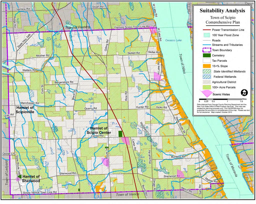
15 Survey respondents registered strong positive opinions, between 60% and 84%, on land use regulation. They gave favorable responses to having land use regulation for the upkeep of vacant properties, siting for wind power, upkeep of occupied properties, mobile home placement, adverse environmental impacts, degradation of environmentally sensitive areas, septic inspection requirements, minimum lot sizes, land use that lowers surrounding land values, rental housing inspection requirements, design standards for commercial development, and future subdivision of large parcels. A strong opposition (85%) was registered against heavy manufacturing in the town of Scipio. Considering that survey respondents so strongly registered their appreciation for farmland, scenic views and open space, and that 31% of farmers taking the survey don t know what they ll do with their farms upon retirement, some important proactive strategies for farmland protection surfaced in the survey results. Between 56% and 67% of respondents think Scipio should give tax incentives for productive land, protect farmland through easements, and limit conversion of farmland to other uses. From these survey responses, some clear conclusions can be drawn. The community s desire for the future of the Town of Scipio depends on the protection of its resources, both natural and cultural, and on improving land use regulations and town government policies with an eye toward accomplishing specific goals and objectives as identified in the survey. These include land-use regulation for the protection of the environment, and preservation of the rural/agricultural character of the town (scenic views), in addition to renewable energy development (wind turbines), affordable housing, and senior housing. Other conclusions raise questions and will require further investigation. For example; if the town pursues natural gas drilling which 65% of survey respondents indicated should be encouraged, will that result in negative environmental impacts which 82% of respondents wish to protect against? These questions must be thoroughly investigated and carefully considered before the community can make wise decisions for the future health and wellbeing of the Town and community. Community Vision Statement: The Town of Scipio would like to preserve its rural character, scenic beauty, and cultural and historic assets, and protect its natural and agricultural resources as it continues to accommodate new growth and services that meet the changing needs of the community. The community survey and the community inventory, and analysis have formed the basis for the following goals and recommendations. These goals and recommendations are referenced in Appendix D Issues of Community Concern/Community Survey. The Suitability Analysis Map for tax parcels in the Town of Scipio (page 17) highlights important physical features of lands in the Town including large (100+ acre) parcels, lands with 15 percent or greater slopes, wetlands, floodplain areas, agricultural districts, scenic vistas, and hamlets. The map provides a visual reference to potentially high priority conservation areas or conditions that call for special attention in future planning and development decisions based on the goals and recommendations in the following chapter. Town of Scipio Comprehensive Plan - January
16 Goals and Recommendations Agriculture and Farmland Protection 1. Preserve the rural-agrarian character of the Town a. Facilitate the protection of farmland balanced with managed community growth and preservation of open space through farmland protection and agricultural easements. b. Facilitate a collaborative relationship with educational institutions and community-oriented organizations in support of local agriculture and the farming community (ex. Sponsor an annual Agricultural Day to educate the general public about the importance of agriculture, local foods, etc.) c. Encourage farmland preservation by working in collaboration with related NYS, County and other agencies and programs. 2. Support future viability of local agricultural practices a. Encourage growth in a wide range of local agricultural services and businesses in support of a sustainable local farming community including local processing and local markets. 2 b. Continue to support the Right-to-Farm law. c. Work with Soil & Water District and Extension personnel on agricultural issues d. Encourage the Town to support tax incentives to keep farmland in production. e. Evaluate and implement tax abatement programs in agricultural assessments from the State Agricultural Assessment Program coupled with comparable penalties for converting farmland to non-farm use. f. Encourage the use of programs such as the Cayuga County Agricultural Environmental Management (AEM) Program for sustainable and best management practices in all agricultural activities in the town Land Use, Planning, and Subdivision Regulation Supportive of the Community Vision 3. Protect the existing open space & scenic views of farmland and lakes in the Town of Scipio a. Review and rework existing Town land use regulations to protect the Town s rural-agrarian and scenic identity while effectively planning for Smart Growth (see Appendix A). b. Work with local or regional planning agencies to develop effective land use tools such as Overlay Districts, Easements, Purchase of Development Rights (PDR) or Transfer of Development Rights (TDR) programs to protect farmland, open space, scenic views, and historic areas in the town. 3 c. Develop a town-wide plan to support low-impact development patterns and land uses that conserve resources, complement the rural character of the residential setting, and encourage farms to remain in farm production, while providing reasonable land area for neighborhoods of single-family dwellings at a medium to low density on a range of lot sizes using conservation-sensitive design (see Appendix B). (The resources, lands and values identified by the community as important to conserve include: rural character, agriculture, highly visible open space lands, scenic views, and wildlife buffer areas). d. Use established environmental protection guidelines to regulate and limit building in areas with steep slopes (15% or more) reducing soil erosion, storm water run-off, and sedimentation of water resources. 2 see Agriculture and Farmland Protection Programs: Local Stakeholder Views, A Report to the New York State Advisory Council on Agriculture, New York State Department of Agriculture and Markets November 5, 2003, 3 See Protecting Aesthetic and Scenic Resources on page 125, Appendix C: Issues of Community Concern 16 Town of Scipio Comprehensive Plan - January 2011
17
18 18 Town of Scipio Comprehensive Plan - January 2011
19 e. Encourage both compact development and preservation of large and continuous areas of absorbent vegetated open space and the minimal overall land disturbance associated with development by allowing flexibility in site planning. 4. Protect the natural resources of significance to the Scipio community. a. Maintain and reference (prior to development decisions) a current map of all natural resources including stream corridors, water bodies, undeveloped shoreline, beaches, wetlands, watershed areas, vegetation communities, woodlands, steep slopes, meadows, specimen trees, wildlife habitats, soils, geology, and aquifer contribution areas. b. Review and amend existing lakefront local laws to ensure both shoreline and water quality protections through adequate minimum shoreline requirements. 4 c. Ensure that site development requirements include standards for Best Management Practices (BMPs) is to minimize soil disturbance, erosion, and stormwater runoff, and ensure that those standards are met particularly in lakefront and streamside areas. 5 d. Encourage sustainable land use practices through the implementation of Incentive or Overlay Zoning as in Riparian zone that identify and protect buffers along stream corridors. 6 e. Establish local watershed preservation overlay districts to delineate protection of water resources Maximize the potential of the town s history and historic resources to become sources of economic and cultural benefit to the community. a. Establish a Local Preservation Commission with the mission of developing an inventory of historic resources in the Town and a Local Preservation District to protect Scipio s historic character b. Adopt a Local Preservation Law that encourages preservation projects by providing tax incentives for investments in preservation district properties, while also establishing a review and approval process for exterior renovations of Local Preservation District properties. (Inclusion in a Local Preservation District increases property owners eligibility for state and federal preservation grant funds. Property owners may elect not to be included in the Local Preservation District and be exempted from the Local Preservation Law and potential preservation grant funding.) c. Apply to NYS Office of Parks, Recreation and Historic Preservation to become a Certified Local Government (CLG) and then seek designation as a Preserve America Community to be eligible for federal preservation grant funding through the Preserve America Grants Program. 4 Excessive development of environmentally sensitive lake shore lands can have direct, adverse water quality impacts. Existing local laws do not assure the preservation of water quality or environmental protection of sensitive shoreline areas. Appropriate shoreline minimum requirements would be best determined by an Environmental Carrying Capacity Study, but in general would are set at 70 of shoreline per dwelling unit where water quality and environmental protection are considered important (see Fair Lake Michigan Environmental Carrying Capacity Study : publications/fairlakeecc.pdf). 5 It is a general rule that 1 acre of impervious surface = 1 million gallons of runoff per year. Carried with that runoff are the many chemicals and particulates that accumulate on lawn, driving and parking surfaces from fertilizers, herbicides and gasoline combustion engines. Permeable surfaces such as green roofs, water permeable concrete, and gravel help to minimize runoff and fi lter out pollutants and reduce their transfer to water bodies. 6 The composition of Land Cover (i.e. forests v.s. lawn, pavement, or frequent tilling) impacts water quality in very different ways. Ecosystem Services such as fi ltration and infi ltration of stormwater runoff can be cost-effectively implemented by incentivising the conversion of frequently tilled land or less pervious surfaces such as lawn and traditional paving to no-till land, meadow, garden, shrubland, or forest. Ecosystem services such as this can prevent the need for a costly traditional engineered municipal water treatment system in the future. 7 Overlay districts are additive restrictions mapped out for specifi c areas such as limits on excavation of soil within 100 feet of a stream corridor, or limits on fuel stations within an aquifer contribution zone. Overlay districts can be used to protect valuable resources without applying broad zoning restrictions to large areas. Three criteria are important in their creation: 1) the district should have a clearly defi ned purpose, e.g. to protect groundwater, prevent erosion, or preserve historical character. 2) areas that relate to achieving the purpose of the overlay district must be identified and mapped. 3) specifi c rules should be developed that apply to the identifi ed district such as development guidelines that require capture and fi ltering of runoff, architectural design guidelines, etc. Town of Scipio Comprehensive Plan - January
20 6. Plan for and seek opportunities to increase the availability of affordable single-family, and senior citizen housing in the Town a. Identify desirable growth areas within or adjacent to existing hamlet areas. b. Explore the possibility of rehabilitating vacant or under-used structures to meet housing demands Environmental Stewardship and Water Quality Protection 7. Support water quality preservation through good stewardship of Owasco Lake and the Owasco and Cayuga Lake watersheds a. Actively seek inter-town cooperation in both watersheds to improve water quality through a unified or coordinated set of zoning and land use regulations for all issues related to water quality and watershed protection. b. Support the development of an agricultural watershed protection program such as the Skaneateles Lake Watershed Agricultural Program (SLWAP) c. Actively work with the Owasco and Cayuga Lake watershed organizations to preserve and improve the quality of the water in both lakes. d. Encourage participation in the Natural Resources Conservation Service (NRCS) Conservation Reserve Program (a program that assists farmers to convert highly erodible crop and pasture land to perennial cover - erosion control buffers) e. Work cooperatively with the County Soil and Conservation District to implement improved and protective roadside ditch maintenance practices to lessen or prevent erosion and pollutant runoff f. Encourage the development of an Environmental Education Outreach Program for town residents g. Protect Owasco and Cayuga Lakes from increased pollution and nutrient run-off both from development and agricultural practices. h. Encourage the use of buffer strips around streams and shorelines to reduce or eliminate run-off. i. Ensure adherence to current regulations and guidelines for the spreading of manure and tilling of soils. j. Encourage Best Management Practices and the minimization of phosphorous and other nutrient loaded fertilizers and products throughout the town. Improved Public Utilities and Services 8. Improve Communications Infrastructure a. Explore options to expand wireless internet access availability for town-wide service b. Explore options to improve/broaden cellular phone service and be pro-active with cell phone companies in locating cell towers. 9. Explore potential benefits and impacts of renewable energy resource development a. Conduct a critical review of both individual and commercial wind energy, solar energy, bioenergy, and potential associated benefits and impacts on the Town. 20 Town of Scipio Comprehensive Plan - January 2011
21 10. Maintain or improve the present quality of Town roads and services a. Review road maintenance procedures to ensure continued quality of town roads b. Work with other town/government agencies to address the impact of heavy truck traffic on the community c. Maintain the Town s current practice of holding 2 clean-up days annually d. Continue the town transfer station program and keep the cost to the taxpayers low. e. Investigate future options for public water districts Community Development and Historic Preservation 11. Encourage the improvement or development of additional community recreational facilities a. Explore options for the acquisition of additional town land for the development of community recreational facilities including parks, recreational trails, playing fields, and lake access. b. Explore options for improving public waterfront recreation areas including amenities at townowned Rights-of-way on Owasco Lake (see photo-concept and plan view, pg ) c. Explore the possibility of developing an interconnected system of hiking trails and bike paths with historic and recreational points of interest throughout the town and hamlets. 12. Seek opportunities to increase community participation and civic resources a. Explore the possibility of upgrading and expanding the Town Newsletter. b. Encourage the development of a community website c. Encourage recruitment of a growing volunteer base for Town organizations 13. Support volunteer recruitment for fire and ambulance services. a. Explore creative ways to provide incentives for community volunteer programs b. Support and implement effective incentive programs for fire and emergency volunteers 14. Expand efforts to support the preservation of the historic heritage of the Town. a. Evaluate the potential for the development of a town history museum in an existing historic structure. b. Coordinate promotion of town historic sites with other regional heritage tourism programs through website links, maps and brochures c. Explore upcoming grant funding opportunities for preservation planning, capital improvements and interpretation of the Sherwood Equal Rights Historic District through the National Park Service Network to Freedom program, the National Women s History Project Act - Votes for Women Trail, and the Save America s Treasures program (see recommendations a, b, and c under Goal 5 as first steps toward this recommendation). Town of Scipio Comprehensive Plan - January


22 Existing conditions at the Town right-of-way to Owasco Lake at Ensenore Road, May Photo-concept showing thetown right-of-way to Owasco Lake at Ensenore Road improved for public recreational use. 22 Town of Scipio Comprehensive Plan - January 2011
23 OWASCO LAKE Previous page (top) shows existing conditions at the Town-owned right-of-way at the end of Ensenore Road on Owasco Lake. The photo-concept at the bottom of the page illustrates how improvements including a waters edge seating deck and small dock, along with a bicycle rack would provide a comfortable community space for enjoyment of the lake shore. Above, a plan view illustrates a potential approximate arrangement of the seating deck, dock, bike rack and parking within the rightof-way, as well as edge planting treatment to provide screening from neighboring properties. Town of Scipio Comprehensive Plan - January

24 Looking east over farmland above Owasco Lake in the Town of Scipio, New York Location Chapter 2: Community Inventory and analysis The Town of Scipio is located south of the center of Cayuga County in the heart of the Finger Lakes Region of Central New York. The Town is bounded on the north by Fleming, on the south by Venice, and on the west by Springport and Ledyard. The eastern border of the Town of Scipio is formed by Owasco Lake. Cayuga County is comprised of a hilly southern plateau where the Town is located, and a relatively flat central plain region with drumlins in the north. Cayuga means People of the Great Swamp in the Iroquoian language of the Cayuga people native to the region. Primarily a rural, agricultural community, Scipio is located to the south of the City of Auburn and is nestled between Owasco Lake to the east and Cayuga Lake to the west, approximately halfway between the southeastern shore of Lake Ontario and the New York/Pennsylvania border. The region features deep north-south valleys bordered by beautiful sloping shorelines occasionally cut by picturesque glens and gorges. ( html) The gently rolling farmland between the lake shores varies in elevation between about 700 and 1400 feet. In places, the landscape of the Town offers spectacular views of the deep, glacially-formed lakes and surrounding farmland. Owasco Lake, though recently indicating a decline in water quality, offers a prime water supply sources to populations in the region. The Town of Scipio is within easy commuting distance of several state and private Colleges and Universities including: Cayuga County Community College, Cornell University, Hobart and William Smith Colleges, Ithaca College, Le Moyne College, Onondaga Community College, Rochester Institute of Technology (RIT), SUNY College of Environmental Science & Forestry (ESF), SUNY - Cortland, SUNY Health Science Center, SUNY - Oswego, Syracuse University, Tompkins-Cortland Community College, University of Rochester, and Wells College. 24 Town of Scipio Comprehensive Plan - January 2011


25 Key Name 1 BRYANT AND STRATTON BUSINESS INSTITUTE-PENN CAN CAMPUS 2 BRYANT AND STRATTON BUSINESS INSTITUTE-SYRACUSE 3 CAYUGA COUNTY COMMUNITY COLLEGE 4 CAZENOVIA COLLEGE 5 CENTRAL CITY BUSINESS INSTITUTE 6 COLGATE UNIVERSITY 7 CORNELL UNIVERSITY 8 CORNING COMMUNITY COLLEGE 9 CROUSE HOSPITAL SCHOOL OF NURSING 10 ELMIRA BUSINESS INSTITUTE 11 ELMIRA COLLEGE 12 FINGER LAKES COMMUNITY COLLEGE Key Name 13 HOBART AND WILLIAM SMITH COLLEGES 14 ITHACA COLLEGE 15 KEUKA COLLEGE 16 LE MOYNE COLLEGE 17 NAZARETH COLLEGE OF ROCHESTER 18 NEW YORK CHIROPRACTIC COLLEGE 19 ONONDAGA COMMUNITY COLLEGE 20 ROCHESTER BUSINESS INSTITUTE 21 SAINT JOHN FISHER COLLEGE 22 SAINT JOSEPH'S HOSPITAL HEALTH CENTER SCHOOL OF NURSING-SYRACUSE 23 SIMMONS INSTITUTE OF FUNERAL SERVICE, INC. 24 STATE UNIVERSITY COLLEGE AT CORTLAND Lake Ontario!( 25 Oswego 81 Carthage Key Name 25 STATE UNIVERSITY COLLEGE AT OSWEGO 26 STATE UNIVERSITY OF NEW YORK COLLEGE OF AGRICULTURE AND TECHNOLOGY AT MORRISVILLE 27 STATE UNIVERSITY OF NEW YORK COLLEGE OF Lowville ENVIRONMENTAL SCIENCE AND FORESTRY AT SYRACUSE 28 STATE UNIVERSITY OF NEW YORK HEALTH SCIENCE CENTER AT SYRACUSE 29 SYRACUSE UNIVERSITY 30 SYRACUSE UNIVERSITY, COLLEGE CENTER OF THE FINGER LAKES OF SYRACUSE UNIVERSITY 31 TOMPKINS-CORTLAND COMMUNITY COLLEGE 32 UTICA SCHOOL OF COMMERCE-CANASTOTA 33 WELLS COLLEGE Adirondack Park Regional Location Colleges & Universities Town of Scipio Comprehensive Plan MAP 1 50 Mile Buffer around the Town of Scipio Municipal Town of Scipio County Boundary Cayuga County Urban Areas Natural Features Water Body NY!( !( 1 Syracuse Lyons 90 Weedsport 390 Newark !( 12 Sodus Canandaigua!( 15!( 30!( 8!( 13 Geneva Seneca Lake Elmira!( 18!( 33 Cayuga Lake Auburn!( 3 Owasco Lake!( 7!( Skaneateles Skaneateles Lake!( 31!(!( 23 19!( 24!( 16 Oneida Lake Chittenango!( 4!( 32 Oneida Scipio!( 26!( 6 Rome Cazenovia Hamilton West NY Salina Utica Little Falls Miles Ilion--Herkimer Data obtained from Cayuga County Planning Department and Canajoharie the New York State Education Department. This map was created for planning purposes only. The CNYRPDB does not guarantee the accuracy or completeness of this map. Please see text for full disclaimer. Map created: October 2009!( 22!( 5 Erie 690!( 28!( 9!( 2 11 UV 92 Cortland State Raynor Park or Forest Transportation James Syracuse Adams Van Buren 81 Limited Access Highway Major Road!( 27 Lodi!( 29 Genesee Euclid I Cat
26 26 Town of Scipio Comprehensive Plan - January 2011


27 Dixon Rd Stanton Rd C A Y U G A L A K E State Route 90 N Yä Yä Backus Rd State Route 90 Main St Cayuga St Gully Rd State Route 90 Lake Rd Cross Rd [ä Springport Dills Rd Town Line Rd Creager Rd Hardy Rd Levanna Rd Sands Rd Ledyard Carpenter R d Honoco Rd Yä Aurelius Black Rock Rd State Route 326 Davis Rd Great Gully Rd Waldron Rd [ä Kings Corners Rd Brick Church Rd Dublin Hill Rd Oakwood Rd Powers Rd Rafferty Rd Ridge Rd Chase Rd [x State Route 34B Britt Rd Pinckney Rd Skillet Rd White Rd State Hwy 34B Cork St SOUTHERN CAYUGA [x Poplar Ridge Rd King Rd Nolan Rd Bluefield Rd Mosher Rd W Corey Rd Fleming Black St Ledyard Rd Dunning Ave Dublin Rd Yw Yw Silver Street Rd Gilling Rd Scipio Venice Town Line Rd State Route 34 Forest Hill Dr Mobbs Rd Scipio Sherwood Rd Yw Indian Field Rd [ [Ç [ Rice Rd [ Skillett Rd Venice Center Rd Wyckoff Rd Long Hill Rd Ford Rd W Lake Rd W Lake Rd Duck Rd Hicks Rd E Lake Rd Sherwood Rd Myers Rd Booth Rd E Venice Rd Town Hall Rd O W A S C O L A K E Burtless Rd Swartout Rd Owasco Fire Lane 18 [ Martin Rd E La ke Rd Widewaters Cross Rd Rockefeller Rd [ Hillcrest Dr State Route 38 Schoolhouse Rd Holley Rd Baptist Corner Rd Austin Rd Gahwiler Rd North Rd Duryea St Harter Rd Hall Rd Marcellus Town of Scipio Comprehensive Plan Rowe Rd Riley Rd Twelve Corners Rd Grange Hall Rd D oolittle Rd Main Rd Oak Hill Rd State Route 3 8A Niles Church Rd Jugg St Moravia Grove St Regional Context MAP 2 Slope Low (1% - 3%) Skaneateles Low to Moderate (4% - 6%) Moderate (7% - 12%) Moderate to High (13% - 20%) High (21% - 45%) Towns County Perennial Stream Intermittent Stream Intermittent Canal Corrigan Rd [ Locke [ Skinner Hill Rd Park Rd DeWitt Rd Split Rock Rd Cream Hollow Rd Decker Hill Rd Murphy Hill Rd MORAVIA Miles Spafford Data obtained from Cayuga County Planning Department and the United States Geologic Survey. This map was created for planning purposes only. The CNYRPDB does not guarantee the accuracy or completeness of this map. Please see text for full disclaimer. Map created: October 2009 Twisting Ln [ Mack Rd Old Salt Rd I State Route 41A Derby Rd Sayles Corners Rd Sempronius Dresserville Rd Brockway Rd Carver Rd Hatheway Rd Sand Hill Rd Summerhill
28 28 Town of Scipio Comprehensive Plan - January 2011

29 The quality of life in Scipio is enhanced by the availability of low-cost, and architecturally intact historical housing, good schools, nearby cultural attractions, parks and recreational opportunities, and low crime rates. Outdoor recreation opportunities abound in central Cayuga County with opportunities for hiking, biking, cross-country skiing, snowmobiling, snowshoeing and enjoying the outdoors. In the Town of Scipio, direct access to Owasco Lake offers opportunities for water activities including boating, sailing, canoeing, kayaking, swimming, and sport fishing, although there is little public access available to these resources. ( History of the Community Cultural History Prior to European colonization, lands in the Finger Lakes Region of Central New York were home to the Haudenosaunee (ho-den-o-shaw-nee) People of the Six Nations of the Iroquois. The Cayugas, one of the six nations, were known as the People of the Great Swamp. The Haudenosaunee raised crops and livestock in clearings, wetlands, and forested areas they maintained near regionally nomadic settlements. During the Revolutionary War, both New York State and the Continental government offered land as a bounty for enlistment in the military forces. In 1779, George Washington launched an effort to clear the Iroquois people from their ancestral homes across New York State, and that year the Sullivan-Clinton Campaign employed over 5,000 troops, roughly one third of the Revolutionary Army in that effort. By Sullivan s official report, the 1779 Campaign burned 40 Haudenosaunee towns and their agricultural fields including those of the settlement at Cayuga Castle just to the west of the Town of Scipio. 8 8 Source: ( Map of the Expedition of the army under General John Sullivan against the Indians of Western New York, in the Seneca and Cayuga lake regions, June 18th to Sept. 15, Manuscript. (Source: Town of Scipio Comprehensive Plan - January
 30 Town of Scipio Comprehensive Plan - January 2011")
30 Land of the Cayugas map created in 1964 showing locations of some Haudenoshaunee villages, sites and orchards in the vicinity of the Town of Scipio prior to the 1779 Sullivan Campaign. (Source: 30 Town of Scipio Comprehensive Plan - January 2011
 to an enlisting private fulfilling a three year enlistment. By July 1782, an area in central New York known as the Military Tract was set aside for this purpose.")
31 On March 20, 1781, in an attempt to raise two military regiments, New York State passed legislation promising bounties of un-appropriated land equal to five times the grant of the federal government (500 acres) to an enlisting private fulfilling a three year enlistment. By July 1782, an area in central New York known as the Military Tract was set aside for this purpose. The Military Tract, located in the Finger Lakes area, Map of the Military Tract of Central New York, 1793 (source: Town of Scipio Comprehensive Plan - January

32 contained 28 Townships, including two Native American reservations for the Cayugas and the Onondagas. In both 1795 and 1807, as the new American colonial government continued to pursue a westward push, the State of New York purchased the lands of the region from the Iroquois, although the state land purchases were never ratified by the U.S. Congress. 9 Each of the subsections or Townships within the Military Tract was comprised of 60,000 acres, and the Townships were named for classical heroes as they were surveyed, mapped and numbered 1 through 26. The townships as originally surveyed were too large and geographically challenging to administer and were gradually divided into smaller towns. Maps of the early 1800s indicate a large reservation of land labeled Cayuga Reservation around the north end of Cayuga Lake and located immediately to the west of what would in 1796 become the western border of the Town of Scipio. Detail of an 1825 map of Scipio and surrounding Towns by Vance showing the extent of the Town of Scipio across Owasco Lake to what is today the Town of Niles. (Source: The Town of Scipio, one of the earliest townships of the Military Tract, was formed March 5th, 1794 and named for a Roman General. It became Township number 12, and originally was contained within what was then Albany County; and included Sempronius (set off in 1799), part of Marcellus, Onondaga County (set 9 Source: (Iroquoia, Engelbrecht, William, 2003) 32 Town of Scipio Comprehensive Plan - January 2011
33 off in 1804), the towns of Ledyard, Venice, and a part of Springport which were set off in It once extended across Owasco Lake to what is presently the Town of Niles. Today, the eastern border of the Town is formed by the west shore of Owasco Lake. At the turn of the nineteenth century, Scipio was largely virgin forest. Prior to cleared roadways, there were paths and blazed trails through the forested lands to Aurora at Cayuga Lake. Wildlife was abundant in Scipio forests; indeed the first town meeting, held in 1794, placed a bounty of $5.00 (raised to $12.50 in 1796) on every grown wolf taken. In the early years following settlement of the Town, and continuing into the first half of the nineteenth century, the major thoroughfare crossing southern Cayuga County in a north-south direction was along Route 34B, then known as Poplar Ridge Road. Travel east and west between Owasco and Cayuga Lake was by way of Sherwood Road. The Hamlet of Sherwood, settled by Judge Seth Sherwood of Vermont in 1794, developed at the intersection of these two early roads and was home to the first county seat, courts, and jail as early as The History of Cayuga County by Elliot G. Storke calls attention to the productive soil in the town which inevitably led to the growth of a wealth of farming enterprises in Scipio. Scipio was the birthplace of portrait artist, Charles Loring Elliott in December of 1812 near Scipio Center. Elliott painted portraits for several years in the western part of New York State and later opened a studio in New York City. He is said to have painted more than 700 portraits of eminent men during the later half of the nineteeth century. Among his subjects were James E. Freeman; Matthew Vassar, in Vassar College; Louis Gaylord Clark; W. W. Coreoran; Fletcher Harper; Fenimore Cooper; Governors Seymour and Hunt, in the New York City Hall; and Erastus Coming, in the New York State Library, Albany. Several of Elliott s works were at the National Academy in 1868, including Don Quixote, Falstaff, Andrew Van Corlear, the Trumpeter, his own portrait, and The Head of Skaneateles Lake, said to be the only landscape that he painted. 12 James Stuart, a British visitor to America, traveled across New York State by stage in September, 1828, on the well-known Genesee Road. In order to see more of the Finger Lakes Region than was possible on this central route, he took a side tour from Auburn to Ithaca which would have had him travelling through or very near the Town of Scipio. The following passages are from his journal: There is a great deal of ground in the neighbourhood [of Aurora] devoted to orchards, at present in all their glory, loaded with fruit. The coachman drove so near the trees close to the road that we had as many apples as we chose to pull. We dined at a small hotel at Aurora on pork, which, as we have always hitherto found it in this country, was excellent. The hogs are allowed in this country to run out in the forests and orchards, where they subsist in great measure in the autumn on nuts, acorns, and fallen apples, and in some cases on fallen peaches. Before being killed they are put up for a short time on Indian corn. The flesh of the hogs fed in this way is firm and good. Our fellow-passengers consisted of a Pennsylvania farmer; an Ithaca storekeeper; and a female, with her son Ulysses. We passed many good farms, some of them recently brought into cultivation, on which the usual processes of housebuilding, and inclosing by strong wooden rails, were in progress Source: 1789 History of Cayuga County, New York, by Elloit G. Storke, Syracuse, NY, pg Source: Sandie Gilliland, Town of Scipio Historian, 12/07/2008, and 1789 History of Cayuga County, New York, by Elloit G. Storke, Syracuse, NY. 12 Source: Edited Appletons Encyclopedia, Copyright 2001 VirtualologyTM 13 From Three Years in North America, by James Stuart, (Edinburgh, 1833), Clayton Mau. Town of Scipio Comprehensive Plan - January

.")
34 Above is a lithograph by J.S. Skinner of the 1850 Agricultural Fair at Auburn, NY showing a variety of livestock, visitors and buildings in an enclosed fairgrounds, looking like an early predecessor of the New York State Fair. (Source: com). At right a Comparitive View of the Agricultural Condition of the County of Cayuga in 1850 and 1845 (Source: rootsweb.ancestry.com). 34 Town of Scipio Comprehensive Plan - January 2011

35 The New York Oswego & Midland Railroad, or the Short Line, as it was also known, was a rail line that travelled during the late nineteenth century by a more central route north and south through the county just to the east of Bolt s Corners and Scipio Summit or Merrifield in the Town of Scipio on its way between Auburn and Ithaca. The Southern Central Railroad along the western shore of Owasco Lake was in operation until nearly the middle of the twentieth century, and for a time it was possible through many connections to travel by steam train from the Town of Scipio to major metropolitan cities including Syracuse, Chicago, New York, and Boston. During and following the Civil War years, at around the time of the introduction of the railroads across Cayuga County, Scipio became a center for social reform movements including abolishionism, the underground railroad, education and women s rights map showing the Southern Central and New York Oswego & Midland Railroads in the Town of Scipio (Source: Town of Scipio Comprehensive Plan - January

.")
36 A predominant contingent of the Society of Friends, or Quaker faith, was catalyst to an unusually dedicated and effective community effort toward equal rights reforms in the young nation including equal access to education provided by the community at the Sherwood Select School, which was organized and operated entirely by women until its absorption into the public school system in Above left, the Sherwood Select School, c The building was demolished in The site is now home to the Emily Howland Elementary School. At right, is a scene showing the boating on Owasco lake, date unknown (Source for both images: 14 National Register of Historic Places Continuation Sheet, Sherwood Historic District, Appendix 1, Page 4 36 Town of Scipio Comprehensive Plan - January 2011

. 15 Source: Cornell Crew Supplement, September 1892, Volume XIII No.")
37 The Southern Central Railroad connected Auburn and Ithaca with local stops at Wyckoff Station just north of the Scipio Town line in Fleming and Culver s Point Station in Scipio. Culver s Point was the location of the Ensenore Glen Hotel where recreational visitors were hosted for the Town s beautiful lake shore for sailing races, swimming, and other popular summer activities. In 1878, a rowing contest was held between Cornell and Harvard University on Owasco Lake. 15 Top image is a postcard from the Ensenore Glen Hotel, date unknown. Bottom image is of boating on Owaso lake, date unknown (Source for both: 15 Source: Cornell Crew Supplement, September 1892, Volume XIII No.2, Ithaca NY Town of Scipio Comprehensive Plan - January
.")
38 1875 map of the Town of Scipio (Source: 38 Town of Scipio Comprehensive Plan - January 2011

39 Hamlets and Historic Settlements As the Scipio population grew to 2,702 in 1829, so too did the need for local products and services. Community settlements and commercial centers of activity developed at Scipio Center, Scipioville, Sherwood, and Bolt s Corners. Smaller settlements developed at Waring s Corners, Merrifield (also known as Scipio Summit), and Wood s Mill which was located on Scipio-Venice Town Line Road between Route 34 and Black Street. Scipio Center Looking north west at the intersection of Route 34 and Center Road in the Hamlet of Scipio Center. Scipio Center is situated on State Route 34 at the intersection of Center Road. According to Elliot Storke, Dr. Ezra Strong started the first store in this location in 1808 which later became a mercantile business and continuing in existence until sometime after Other businesses once in operation at Scipio Center included a cider-mill, two wagon shops, two blacksmith shops, and a hotel. Today, the hamlet of Scipio Center consists of a cluster of several residences, Scipio Community Church, River of Life Church (former St. Patrick Catholic Church), a Post Office, Masonic Lodge, a hair salon, an auto refinishing shop, a tavern, and a monument company. There are several nineteenth and early twentieth century buildings still standing in the hamlet. Some are in very good physical condition, and some, although their historic character remains intact, are in dire need of repairs and restoration. Scipio Center, characterized by a mix of stately historic homes, barns, and small twentieth century buildings and surrounded by open farm fields, is the most geographically extensive hamlet in the Town of Scipio. It is the only hamlet in the Town with two churches and contiguous development extending approximately 1000 feet in four directions from it s center. State Route 34, a busy connector road between Auburn and Ithaca, runs north and south through the hamlet. Center Road runs east and west through the Hamlet connecting State Route 38 above the shores of Owasco Lake with State Route 34B and the Hamlet of Scipioville and Levanna to the west. Town of Scipio Comprehensive Plan - January


40 The southwest corner of State Route 34 and Center Road in the Hamlet of Scipio Center. Two buildings at the southeast corner of State Route 34 and Center Road in the Hamlet of Scipio Center. Looking north along State Route 34 at the southern edge of the Hamlet of Scipio Center. 40 Town of Scipio Comprehensive Plan - January 2011

41 Scipioville Scipioville (below) is in the western part of the township, at the intersection of State Rt. 34B and Center and Levanna Road. The community was first settled by Henry Watkins in , and was called Watkin s Corners. Later it became known as Fitch s Corners, Mechanicsburg, and finally Scipioville in 1836 with the establishment of the first post office. A leather currier and tannery was started in Scipioville in In 1806, Paine Fitch built a tavern, and there were two general stores, one on the southwest corner and one on the northeast corner. A distillery, tin shop, creamery, fertilizer storage, meat shop, buggy shop, and a grist, saw and planning mill were also located there. Webster s hotel was located on the southeast corner of Scipioville, and a building to the east of the hotel once served as a community dance hall. Aerial image of the Hamlet of Scipioville (Source: Today, Scipioville consists of a small cluster of residences mainly to the east of Route 34B including Scipioville Presbyterian Church (moved in 1961 from east of the four corners on Center Road to a new location on Route 34B within the hamlet). Farm buildings, surrounding farm fields, hedgerows, and a scattering of small wood lots and ponds also characterize the hamlet. Town of Scipio Comprehensive Plan - January


42 Looking southwest in the Hamlet of Scipioville, May Scipioville Presbyterian Church was moved in 1961 from east of the four corners on Center Road to this location on Route 34B in the Hamlet of Scipioville. 42 Town of Scipio Comprehensive Plan - January 2011

.")
43 Sherwood The Hamlet of Sherwood, settled by Judge Seth Sherwood from Vermont in , is located to the south of Scipioville at the intersection of State Rt. 34B and Sherwood Road. A short time prior to the hamlet s settlement by Judge Sherwood, a family named White settled in the area, clearing about four acres of land about a half mile southeast of the corners. Aerial image of the Hamlet of Sherwood (Source: In 1796, Judge Sherwood built the first hotel on land just to the north on the northeast corner (the site of the present antique store, historically called The Block). A later owner, Henry Fisher built a harness shop in back of the hotel. For a brief time, in , the Hamlet of Sherwood served as the County seat. In 1808, Joseph Barnes and Melvin Brown opened a store on the southeast corner dealing in potash. The upper floors of this building housed a shoe and boot store. Slocum Howland later used the barn to the east of this building to assemble the cast iron plows invented by Jethro Wood. During the eighteenth and early nineteenth centuries, Sherwood was a lively community and a center for abolitionism, equal rights, and the Underground Railroad movements with Quaker settlers actively assisting freedom seekers. Looking east at Cleavland s Antiques and the Howland Stone Store Museum at the center of the Hamlet of Sherwood, May Town of Scipio Comprehensive Plan - January

44 Today, the historic Hamlet features a mix of small and grand, deteriorated and restored, historic residential and commercial buildings. The Hamlet features many mature trees, old farm buildings and is surrounded by open farm fields. An early racially integrated cemetery, a reminder of the settlement s important historic role in the abolitionist movement, is located in Sherwood. Although the Hamlet has been dubbed the Sherwood Equal Rights Historic District by the State of New York for it s rich history of social activism, and has been listed on the National Register of Historic Places, Sherwood today struggles to maintain many of its aging and largely neglected historic structures. Some of the historically important buildings that remain in the hamlet are literally crumbling from years of neglected maintenance, or abandonment added to the effects of age and weather. Others remain in poor to fair condition and await much needed investments of labor and money. Still, the compact rural Hamlet remains a striking reminder and record in both physical form and documented history, of the community s, the State s, and the Nation s early settlement, development, and participation in key historical movements. Bolt s Corners The intersection of Sherwood Road, Black Street and Indian Field Road is the site of one of the earliest settlements in the Town of Scipio, Bolt s Corners. Its first settlers, Elisha Durkee and Gilbert Tracy arrived in 1788, each clearing some land and building log cabins there. James Wilcox acquired land and built a hotel in 1789, and in the nineteenth century, Bolt s Corners was an active community center. As the settlement grew, businesses at Bolt s Corners included an ashery, saw mill, grist mill, and brickyard. A significant building constructed at Bolt s Corners, a church built in 1821, had a steeple over 100 feet high, and in 1828 the congregation had a membership of over 300 people. A short line, the New York & Oswego Midland Railroad Milk Train passed through Scipio just east of Bolt s Corners during the late nineteenth century contributing to the hamlet s status as a commercial center where the local community came to purchase every day supplies. In the late nineteenth century, Bolt s Corners was the prime social and business center in the area, outside of the settlement of Aurora to the west on the shore of Cayuga Lake. Looking west at Valley Mound Farm on the northeast corner of Bolt s Corners in the Town of Scipio, May Town of Scipio Comprehensive Plan - January 2011

.")
45 Today, Bolt s Corners is a rural four corners featuring a cluster of agricultural buildings and facilities on both the southwest and northeast corners. Open land and vast expanses of farm fields surround the crossroads, and the trace of the former New York & Oswego Midland Railroad remains alongside Salmon Creek to the east of the crossroads. One old homestead remains on the northwest corner of the former hamlet map of the Town of Scipio showing the location of Merrifi eld between Scipio Center and Scipioville (Source: genealogy.rootsweb.ancestry.com). Waring s Corners The intersection of Sherwood Road and State Route 34 is known as Waring s Corners. The southwest corner, now marked with a State Historic Marker, was once the site of Waring Place, a tavern built in 1806 and later used as both a Masonic Lodge and school house. Meetings of the Scipio Morning Star Lodge 169 F. & A.M. were held at Waring Place from 1811 to1814, and again from 1822 to The intersection, today, features a farmstead on the northeast corner and a residence on the southwest corner. A small tributary to Salmon Creek cuts diagonally through the area just to the north of the crossroads which are surrounded by vast and open cultivated fields. Scattered hedgerows remain between some of the open fields and some mixed vegetation exists along parts of the stream corridor. Town of Scipio Comprehensive Plan - January

46 Scipio Summit (Merrifield) Scipio Summit, or Merrifield as it is also known, is located just south of the intersection of Center Road and Black Street. It was the designated location about equally distant from settlements at Scipio Center, Scipioville, and Sherwood. 1872, Charles Morgan started a business in this location which included the sale of lumber, and grain. Mr. Morgan was also the agent for the railroad and the telegraph company. Of the two stores once located in Merrifield, one was in the basement of a residence, and the other at the railroad station. A post-office was established in Merrifield in Scipio Summit, or Merrifield, served as the northern terminus of the Utica, Ithaca and Elmira Railroad between 1873 and The line was extended from Merrifield to Auburn in 1889 as the Ithaca, Auburn & Western Line, but was abandoned in just three years later in1891. Today, the quiet, rural-agrarian settlement of Scipio Summit seems more aptly-named Merrifield. With just a few residences, barns and farm fields, and the railroad long gone, the scenic location is more of a sleepy wayside than a centrally-designated place in the Town. 46 Town of Scipio Comprehensive Plan - January 2011
47 Historic and Cultural Resources The scenically unique rural-agrarian landscape of the Finger lakes Region. This view is looking northeast across a farm field from Ensenore Road in the Town of Scipio, The Rural-Agrarian Landscape As described by O. D. Von Engeln in his 1988 book The Finger Lakes Region, Its Origin and Environment, the Town of Scipio is located in a region that is scenically unique. Von Engeln s description of the geographical environment of the Finger Lakes Region with its general expression wide farm acres and level upland pastures [amid] long, narrow, roughly parallel lakes...with high, almost cliff-steep shores.[and] narrow, deep gorges is an accurate description of the landscape surrounding the Town of Scipio. Located roughly halfway between NYS Designated Scenic Routes 20 and 90 to the north and south respectively, Scipio is at the heart of the picturesque region of the eastern Finger Lakes. NYS Routes 38, 34, and 34B originate in the City of Auburn and cross the Town of Scipio to the south continuing on to Ithaca and Dryden in Tompkins County. There are scenic vistas of farmland gently sloping toward Owasco Lake along Route 38 in the Town of Scipio. Route 34 bisects the Town between the Hamlet of Fleming just north of Scipio and heading south to the Hamlet of Venice. Route 34B is a scenic two lane rural-agrarian road featuring picturesque farm fields with historic barns and buildings along its course. Town of Scipio Comprehensive Plan - January


48 Several roads in the Town of Scipio feature scenic views of historic buildings and vast acres of farmland, some of them are spectacular from the heights above the lakes to the east and west. Some of the most impressive publicly accessible views in the Town are the eastward view from the heights of Sherwood Road of farmland sloping to Owasco Lake, and the southwestward view over Scipio farmland from Center Road and State Route 34 near the Hamlet of Scipio Center. The historic Hamlet of Sherwood with it s compact cluster of diverse nineteenth century homesteads and commercial buildings surrounded by farm fields on State Route 34B is an architecturally unique surviving example of traditional American rural hamlet form (see Map 3). There are beautiful northeastern views of Owasco Lake from Duck Road and Wyckoff Road in the northern section of the Town. View from Duck Road in the northern part of the Town of Scipio, Farmland along Sherwood Road looking east toward the slope above Owasco Lake, Town of Scipio Comprehensive Plan - January 2011
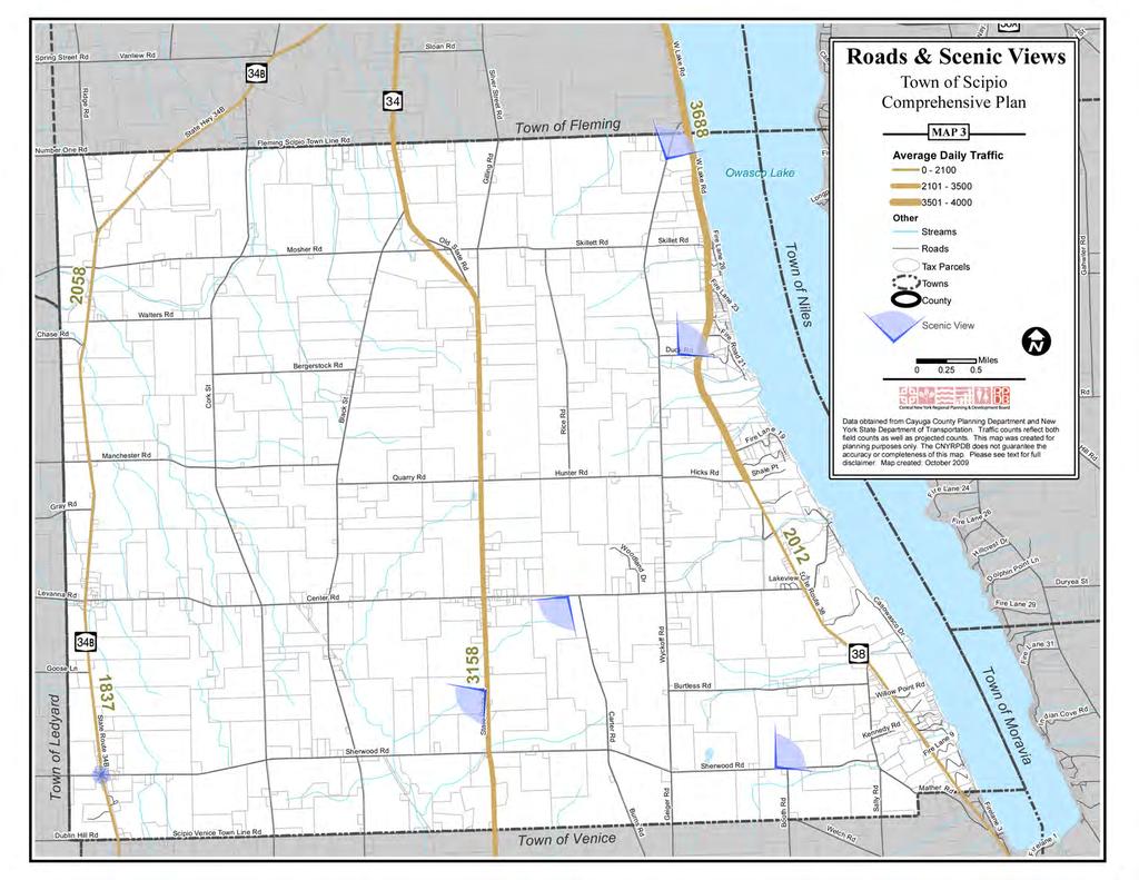
49
Town of Genoa Comprehensive Plan - April
 Town of Genoa Comprehensive Plan - April 2013 1 2 Town of Genoa Comprehensive Plan - April 2013 Table of Contents Introduction... 5 Public Participation... 6 Plan Structure... 7 Adopting and Implementing
Town of Peru Comprehensive Plan Executive Summary
 Town of Peru Comprehensive Plan Executive Communities that plan grow by choice, not by chance. A plan makes growth thoughtful, understandable, and predictable. A plan shows that a community is managing
Town of Victory Comprehensive Plan - May
 Town of Victory Comprehensive Plan - May 2011 1 2 Town of Victory Comprehensive Plan - May 2011 Table of Contents Introduction... 5 Chapter 1 Goals and Recommendations... 7 Community Vision Statement...
CHAPTER 4 FUTURE LAND USE AND URBAN SERVICES DISTRICTS
 CHAPTER 4 FUTURE LAND USE AND URBAN SERVICES DISTRICTS Introduction This chapter discusses how Benzie County should grow and change in the future. A community can grow and change in many different ways.
This page intentionally blank.
 This page intentionally blank. Parks, Recreation, and Open Space Chapter Relationship to Vision Vision Parks, Recreation and Open Space Chapter Concepts County Government. County government that is accountable
Arlington, Virginia is a worldclass
 EXECUTIVE S U M M A RY Arlington maintains a rich variety of stable neighborhoods, quality schools and enlightened land use policies, and received the Environmental Protection Agency s highest award for
SALISBURY TOMORROW Our Vision
 SALISBURY TOMORROW Our Vision Salisbury is committed to supporting a high quality of life and sense of community for all residents. These commitments need to be reflected in our community programs, services
Planning for and Managing Open Space and Natural Areas
 Planning for and Managing Open Space and Natural Areas Increasingly, development proposals in Delaware include large amounts of open space and natural areas. While open space is important as a community
Chapter 3. Community Vision and Goals
 Chapter 3. Community Vision and Goals 3.1 Public Involvement Charlevoix s master plan was prepared in a way that maximized public participation. Dating back to 2004, the Planning Commission and staff held
SECTION II SECTION II STATEMENT OF GOALS, OBJECTIVES, PRINCIPLES, ASSUMPTIONS, POLICIES AND STANDARDS
 STATEMENT OF GOALS, OBJECTIVES, PRINCIPLES, ASSUMPTIONS, POLICIES AND STANDARDS 1 2 STATEMENT OF GOALS, OBJECTIVES, PRINCIPLES, ASSUMPTIONS, POLICIES AND STANDARDS INTRODUCTION The New Jersey Municipal
Update to Town of Owasco Comprehensive Plan
 Update to Town of Owasco Comprehensive Plan with Conservation Lands and Trails Plan September 2016 Town of Owasco Comprehensive Plan Update - April 2016 1 Table of Contents Introduction... 5 Public Participation...
TOWN OF SPRINGFIELD, NEW HAMPSHIRE
 TOWN OF SPRINGFIELD, NEW HAMPSHIRE NATURAL RESOURCES INVENTORY EXECUTIVE SUMMARY March 2008 Prepared by: Watershed to Wildlife, Inc. Natural Resource Consultants 42 Mill Street, Suite 3 Littleton, NH 03561
CHAPTER 12 IMPLEMENTATION
 CHAPTER 12 IMPLEMENTATION The 2010 Town of Denton Comprehensive Plan is intended to capture a vision of the future of Denton. As such, it provides a basis for a wide variety of public and private actions
3. VISION AND GOALS. Vision Statement. Goals, Objectives and Policies
 Vision Statement Queen Creek s interconnected network of parks, trails, open spaces and recreation opportunities provide safe and diverse activities and programs that sustain its unique, small town, equestrian
Preface. Erie. Scranton. Allentown. Pittsburgh. Harrisburg. Philadelphia
 The Southern Alleghenies Region The Southern Alleghenies Region spans the Laurel Highlands and Allegheny Front in the west across the Appalachians to the east. It is comprised of Blair, Bedford, Cambria,
Municipal Plan*Assessment
 Municipal Plan*Assessment This tool was developed to assist in reviewing municipal master plans and in determining if these plans are consistent with smart growth principles, neighboring municipal plans,
DRAFT Amsterdam/Churchill Community Plan (4/17/08) Adopted By the Gallatin County Commission
 Adopted By the Gallatin County Commission") DRAFT Amsterdam/Churchill Community Plan (4/17/08) Adopted By the Gallatin County Commission Table of Contents Acknowledgements Chapter 1: Introduction A Brief History What s Next Authority Organization
DRAFT Amsterdam/Churchill Community Plan (4/17/08) Adopted By the Gallatin County Commission Table of Contents Acknowledgements Chapter 1: Introduction A Brief History What s Next Authority Organization
STEWARDSHIP OF LONG ISLAND SOUND S ECOLOGICAL AND RECREATIONAL RESOURCES
 STEWARDSHIP OF LONG ISLAND SOUND S ECOLOGICAL AND RECREATIONAL RESOURCES Robin Kriesberg, Save the Sound, Inc. Thomas Halavik, US Fish and Wildlife Service Coastal Program An Initiative to Identify, Protect
HOUSING ELEMENT GOALS, OBJECTIVES, AND POLICIES
 HOUSING ELEMENT GOALS, OBJECTIVES, AND POLICIES Goal 6 Maintain and enhance the supply of decent, safe, energy efficient and affordable housing and maximize viable options and opportunities for present
Improve Neighborhood Design and Reduce Non Point Source Water Pollution
 HOW TO Planning Guide Improve Neighborhood Design and Reduce Non Point Source Water Pollution This document was funded by a grant from the New Hampshire Coastal Program with funding from the National Oceanic
Village of Fair Haven Goals & Objectives
 Village of Fair Haven Goals & Objectives 1 Natural Environmental Quality & Aesthetics Embrace policies and programs that preserve and enhance the Village s natural resources, environment, water quality,
RECREATION AND OPEN SPACE ELEMENT GOALS, OBJECTIVES, AND POLICIES
 RECREATION AND OPEN SPACE ELEMENT GOALS, OBJECTIVES, AND POLICIES Goal 7 To provide park facilities, recreation programs, and open space resources that are safe, adequate, and accessible to all City residents,
TOWN OF BETHLEHEM OPEN SPACE CONSERVATION PLAN PUBLIC MEETING: OCTOBER 12, 2017
 TOWN OF BETHLEHEM OPEN SPACE CONSERVATION PLAN PUBLIC MEETING: OCTOBER 12, 2017 Welcome and Agenda 6:00 6:45: Open House, Part One 6:45 7:15: Presentation and Questions 7:15 8:00: Open House, Part Two
Executive Summary. Parks and Recreation Plan. Executive Summary
 Parks and Recreation Plan Executive Summary The Whitemarsh Township Parks and Recreation Plan sets forth a vision for how Whitemarsh Township can provide a premiere parks and recreation system reflective
CONSERVATION ELEMENT GOALS, OBJECTIVES, AND POLICIES
 CONSERVATION ELEMENT GOALS, OBJECTIVES, AND POLICIES Goal 4 To conserve, manage, appropriately use and protect the natural resources of the City ensuring continued resource availability and environmental
Planned Development Review Revisions (Project No. PLNPCM )
") Planned Development Review Revisions (Project No. PLNPCM2014-00139) Standard residential development Planned Development Example: Smaller lot sizes than what is allowed to create open space amenity. What
Planned Development Review Revisions (Project No. PLNPCM2014-00139) Standard residential development Planned Development Example: Smaller lot sizes than what is allowed to create open space amenity. What
Sorted citizen input comments in review of Blount County plans July, August, and September 2007
 Sorted citizen input comments in review of Blount County plans July, August, and September 2007 The following presents sorted citizen input comments from three sessions held in July, August and September
COMMUNITY DESIGN. GOAL: Create livable and attractive communities. Intent
 COMMUNITY DESIGN Intent An attractive, well-designed County will attract quality development, instill civic pride, improve the visual character of the community, and create a strong, positive image for
Support the implementation of Cape Coral's Comprehensive Plan. Protect and utilize the unique natural resources in the City.
 7.0 OVERVIEW - RECOMMENDATIONS Chapter 7 The preparation of the Cape Coral Parks and Recreation Master Plan spanned a period of approximately 12 months. Plan preparation included the input of a wide range
2018 Northampton Township Comprehensive Plan
 2018 BUCKS COUNTY, PENNSYLVANIA What is a? A comprehensive plan is a municipality s main policy document that details the collective vision for the future, the historic, environmental, and cultural facilities
Chapter 10 IMPLEMENTATION RECOMMENDATIONS
 Chapter 10 IMPLEMENTATION RECOMMENDATIONS The recommended land use plan presented in the previous chapter provides a design for the attainment of the urban and rural development and open space preservation
G. RECREATION AND OPEN SPACE ELEMENT. The following summarizes the Recreation and Open Space Element:
 G. RECREATION AND OPEN SPACE ELEMENT The purpose of the Element is to provide the framework and direction for a comprehensive system of public and private sites for recreation, including, but not limited
Shoreline Master Program Town of La Conner, Washington
 Shoreline Master Program Town of La Conner, Washington Department of Ecology approval effective Adopted September 24, 2013 by Town of La Conner Ordinance No.1106 Amended May 13, 2014 by Town of La Conner
Lake O the Pines Master Plan Revision Public Information Meeting April 25 & 27, 2017
 Lake O the Pines Master Plan Revision Public Information Meeting April 25 & 27, 2017 Presented By Matthew Like, Lake Manager U.S. Army Corps of Engineers Fort Worth District US Army Corps of Engineers
2040 LUP is a part of the Comprehensive Plan and carries the same legal authority. Economic Challenges
 1.1. Guiding Anchorage s Growth Where will new residents settle over the next two decades? Where will people work, shop, and play? Will there be enough room to grow? How will Anchorage look? Will growth
Central Lake Ontario Conservation Conservation Lands Master Plan
 Conservation Lands Master Plan Top 13 Frequently Asked Questions 1. What are conservation lands? Where are these conservation lands located in the Central Lake Ontario Conservation watershed? Conservation
NEW CASTLE COUNTY S ZONING DISTRICTS
 NEW CASTLE COUNTY S ZONING DISTRICTS This is general information about New Castle County s zoning districts. The information included is by no means exhaustive or complete. Before designing plans to develop
Green Infrastructure Policies and Ordinances
 Green Infrastructure Policies and Ordinances October 23, 2013 By Karen Firehock, Green Infrastructure Center 2013 Georgia Urban Forest Council s 23 rd Annual Conference The mission of the nonprofit Green
Chapter 13: Implementation Plan
 Implementation A. Introduction The Implementation Plan, in table form on the following pages, provides a summary of all the Action Items recommended in Chapters 2 through 12. The table also indicates which
{Best Practices. Summary of Tools, Strategies and Best Practices from 11 Michigan Case Study Communities
 Case Studies Michigan Coastal Community Working Waterfronts { Summary of Tools, Strategies and from 11 Michigan Case Study Communities Table of Contents Zoning...2 Community and Stakeholder Collaboration
OPEN SPACE CHAPTER 7: OVERVIEW. Preserve open space to protect natural resources, enhance character and provide passive recreation opportunities
 CHAPTER 7: OPEN SPACE OVERVIEW Ridgefield has made tremendous progress permanently preserving areas of town as open space. Open space preservation can serve many important purposes, including: protect
DISCUSSION TOPIC: ST JOHNS RIVER & ITS TRIBUTARIES (BPII) 2030 COMPREHENSIVE PLAN POLICES AND REGULATORY FRAMEWORK
 2030 COMPREHENSIVE PLAN POLICES AND REGULATORY FRAMEWORK") DISCUSSION TOPIC: ST JOHNS RIVER & ITS TRIBUTARIES (BPII) 2030 COMPREHENSIVE PLAN POLICES AND REGULATORY FRAMEWORK St. John s River & Its Tributaries Issue Summary: The St. Johns River is an important
DISCUSSION TOPIC: ST JOHNS RIVER & ITS TRIBUTARIES (BPII) 2030 COMPREHENSIVE PLAN POLICES AND REGULATORY FRAMEWORK St. John s River & Its Tributaries Issue Summary: The St. Johns River is an important
Sustainable Keuka Lake
 Sustainable Keuka Lake Steve Butchko, Town of Wayne Supervisor Chelsea Robertson, Senior Planner STC Kemberli Sargent, Planner STC www.sustainablekeuka.net This presentation was prepared for the New York
Section 4 BUILDING THE MASTER PLAN
 The Master Plan 33 Section 4 BUILDING THE MASTER PLAN Figure 4:1. A collaborative effort characterized the two design workshops sponsored by DISC to create hypothetical Master Plans for the Towers Property
Subject: Hendry County Evaluation and Appraisal Report Letter of Understanding - Identification of Major Issues
 HENDRY COUNTY PLANNING & ZONING DEPARTMENT POST OFFICE BOX 2340 165 S. LEE STREET LABELLE, FLORIDA 33975 (863) 675-5240 FAX: (863) 675-5317 SUNCOM 744-4750 November 16, 2007 Mr. Mike McDaniel, Chief Office
Land Use Amendment in Southwood (Ward 11) at and Elbow Drive SW, LOC
 at and Elbow Drive SW, LOC") 2018 November 15 Page 1 of 10 EXECUTIVE SUMMARY This land use amendment application was submitted by Rick Balbi Architect on 2017 August 31 on behalf of Sable Developments Ltd, and with authorization from
2018 November 15 Page 1 of 10 EXECUTIVE SUMMARY This land use amendment application was submitted by Rick Balbi Architect on 2017 August 31 on behalf of Sable Developments Ltd, and with authorization from
DRAFT MAP AMENDMENT FLU 04-4
 DRAFT MAP AMENDMENT FLU 04-4 SW 24 TH AVENUE ROADWAY CORRIDOR The University of Florida participates with the Metropolitan Transportation Planning Organization (MTPO) in its responsibilities for the continuing,
CHAPTER 2: PLANNING PRINCIPLES
 CHAPTER 2: PLANNING PRINCIPLES 2 Comprehensive Principles The following overarching Principles provide the basis for the goals and policies included in the Mendocino County General Plan. These Principles
Minnesota Department of Natural Resource - Natural Resource Guidance Checklist Conserving Natural Resources through Density Bonuses
 Minnesota Department of Natural Resource - Natural Resource Guidance Checklist Conserving Natural Resources through Density Bonuses NRDB Why Use Density Bonuses & This Checklist Local units of government
RECREATION, OPEN SPACE AND GREENWAYS ELEMENT GOALS, OBJECTIVES, AND POLICIES
 RECREATION, OPEN SPACE AND GREENWAYS ELEMENT GOALS, OBJECTIVES, AND POLICIES GOAL R-1: DEVELOP A RECREATION, OPEN SPACE AND GREENWAYS SYSTEM AS AN INTEGRAL COMPONENT OF AN OVERALL, COUNTY-WIDE ECONOMIC
Implementation Vision
 Introduction The implementation chapter is the how to portion of the plan. It describes the actions necessary to realize the visions presented in this document through the goals, objectives, and policies
IV. Development in the Rural Overlay District
 Intracoastal Waterway Route 17 Route 168 Great Dismal Swamp VIRGINIA NORTH CAROLINA IV. Development in the Rural Overlay District IV-1 Route 17 in Chesapeake s Rural Overlay District affords distant views
1 Introduction. Chapter. In this chapter:
 Chapter 1 Introduction In this chapter: 1.1 A Snapshot of the Region 1.2 Towards a Sustainable Region 1.3 The Provincial Context 1.4 Purpose and Organization The Regional Municipality of York Official
4-Town Comprehensive Plan DRAFT 7/30/07
 4-Town Comprehensive Plan DRAFT 7/30/07 Acknowledgements ning Committee Town of Harrisburg Norman Roof Randy Nicol Town of Martinsburg Terry Thisse Paul Kelly Town of Montague Jan Bagdanowicz Wendy Perry
PSRC REVIEW REPORT & CERTIFICATION RECOMMENDATION
 PSRC REVIEW REPORT & CERTIFICATION RECOMMENDATION KITSAP COUNTY COUNTYWIDE PLANNING POLICIES July 2, 2012 BACKGROUND A major emphasis of the Washington State Growth Management Act (GMA) is the need to
TABLE OF CONTENTS. Transportation Chapter 1 - Introduction and Purpose of Planning to 1-3. Utilities
 Chapter 1 - Introduction and Purpose of Planning... 1-1 to 1-3 Pennsylvania Municipalities Planning Code (Act 247)...1-1 Previous County Planning Activities...1-1 Objectives of the Plan...1-2 Elements
Zoning and Development Considerations in the Boothbay Harbor Maritime/Water Dependent District
 Zoning and Development Considerations in the Boothbay Harbor Maritime/Water Dependent District Bob Faunce Lincoln County Planner Lincoln County Regional Planning Commission Board of Selectmen and Planning
SECTION FOUR: MISSION STATEMENT, GOALS & OBJECTIVES
 SECTION FOUR: MISSION STATEMENT, GOALS & OBJECTIVES Chapter Summary Chapter Ten: Mission Statement, Goals & Objectives To fulfill its mission, the Parks and Recreation Commission has identified four basic
ARTICLE VI AGRICULTURAL PROTECTION DISTRICT
 A. Findings and Purpose ARTICLE VI AGRICULTURAL PROTECTION DISTRICT The Town of Northumberland finds that the protection of agriculture is essential to the implementation of the goals and objectives ofthe
I. STAFF POLICY RECOMMENDATIONS. The following RMP policy strategies are proposed by staff in support of a Scenic Resource Protection Program:
 Policy Consideration: Scenic Resource Protection Program Status: For Consideration by the Highlands Council at September 14, 2006 Work session Date: September 12, 2006 I. STAFF POLICY RECOMMENDATIONS The
Canyon Lake Master Plan Revision Public Information Meeting March 18, 2016
 Canyon Lake Master Plan Revision Public Information Meeting March 18, 2016 Marcus Schimank Canyon Lake Manager Capital Regional Office U.S. Army Corps of Engineers Fort Worth District US Army Corps of
10.0 Open Space and Public Realm
 10.0 Open Space and Public Realm 10.0 Open Space and Public Realm The Public Open Space System is comprised of: outdoor spaces available for public use that are either publicly owned (e.g., parks and
CHAPTER 1 Introduction
 CHAPTER 1 Introduction From sea to summit, Lane County covers almost 4,800 square miles of diverse Oregon landscape. Stretching from the Pacific Ocean through the Coastal Range, the Willamette Valley to
Green Infrastructure. NYS Department of Environmental Conservation
 Green Infrastructure Green infrastructure is an interconnected network of natural areas and open spaces that sustains ecosystems. Benedict, M.A. and E.T. McMahon. 2006. Green Infrastructure Linking Landscapes
Yadkin River Greenway Feasibility Study Fact Sheet Village of Clemmons, Town of Lewisville, Town of Bermuda Run
 Fact Sheet Village of Clemmons, Town of Lewisville, Town of Bermuda Run Project Background The Yadkin River Greenway Feasibility Study is a joint project with the Village of Clemmons, the Town of Bermuda
Conservation Corridor Planning and Green Infrastructure Themes
 Conservation Corridor Planning and Green Infrastructure Themes Prepared by the Green Infrastructure Center Inc. and the Northern Virginia Regional Commission February 22, 2011 Brief Overview Project Background
Joe Pool Lake Master Plan Revision Public Information Meeting May 23, 2017
 Joe Pool Lake Master Plan Revision Public Information Meeting May 23, 2017 Presented By Jason Owen Lake Manager U.S. Army Corps of Engineers Fort Worth District US Army Corps of Engineers Purpose of this
SECTION UNIFIED DEVELOPMENT ORDINANCE SECTION Part 1 Ordinance. ARTICLE 1 Zoning Districts
 SECTION 1-100 UNIFIED DEVELOPMENT ORDINANCE SECTION 1-300 Part 1 Ordinance SECTION 1-100. Introduction. ARTICLE 1 Zoning Districts Crystal Lake strives to maintain a balance of various land uses for a
Concord Community Reuse Project Goals and Guiding Principles. Overarching Goals (OG)
") Concord Community Reuse Project Goals and Guiding Principles Overarching Goals (OG) No priority is implied by the order of presentation of the goals and guiding principles. Overarching goals for the Concord
Concord Community Reuse Project Goals and Guiding Principles Overarching Goals (OG) No priority is implied by the order of presentation of the goals and guiding principles. Overarching goals for the Concord
A BLUEPRINT FOR BROCKTON A CITY-WIDE COMPREHENSIVE PLAN
 A BLUEPRINT FOR BROCKTON A CITY-WIDE COMPREHENSIVE PLAN Public Meeting October 2016 1 Plan Summary and Discussion Public Meeting May 4 2017 City of Brockton Bill Carpenter, Mayor Department of Planning
Town of Cobourg Heritage Master Plan. Statutory Public Meeting
 Town of Cobourg Heritage Master Plan Statutory Public Meeting April 25 th 2016 Presentation Overview 1. Introduction 2. Project background and schedule overview 3. Review of strategic direction content
Recreation, Open Space, Greenway Plan & Smart Agriculture Initiative
 Recreation, Open Space, Greenway Plan & Smart Agriculture Initiative This portion of the Plan represents a follow-up to Section 2, which addressed the natural environment of the two townships. This portion
A Growing Community Rural Settlement Areas
 Town of Huntsville Official Plan Review - POLICY BACKGROUND PAPER A Growing Community Rural Settlement Areas BACKGROUND: In addition to the fully municipally-serviced Urban Settlement Area and the Hidden
FARMLAND PRESERVATION AND PUBLIC POLICY ISSUES
 FARMLAND PRESERVATION AND PUBLIC POLICY ISSUES Lancaster County, home to the richest, most productive agricultural soils in the country, faces a tough battle in efforts to preserve our home, our harvest,
Official Plan Review
 Official Plan Review Summary Report - The Built Environment August 2014 Part 1: Introduction Planning for a healthy, prosperous and sustainable community is an important goal for our municipality. From
implementation10 Village of Greendale Comprehensive Plan: Greendale, Wisconsin. Revisiting a Greenbelt Community
 implementation10 Village of Greendale Comprehensive Plan: 2010 - Village of Greendale Comprehensive Plan: 2010 - Implementation The recommendations of this Plan must be implemented by the Village of Greendale,
Community Conservation Workshop. Lake Placid
 Community Conservation Workshop Lake Placid 2 Community Conservation Program Welcome! We have designed a Community Conservation Program that listens to the needs of community members. We are conducting
Chapter 2: Vision, Goals and Strategies
 Chapter 2: Vision, Goals and Lake Elmo Today & Tomorrow Comprehensive Plan 2040 2 VISION, GOALS & STRATEGIES - DRAFT 4-6-2018 INTRODUCTION Comprehensive Plan Purpose Perhapse the most important objective
Chapter 9 Community Facilities & Services Plan. Introduction. Cooperative Efforts. Monitoring of Needs
 Chapter 9 Community Facilities & Services Plan Introduction The location of key community facilities such as water, sewer, schools, parks, and roads is important to the provision of the necessary services
Purpose of the Master Plan
 Purpose of the Master Plan 4 Master Plan Purpose The Master Plan is a policy framework for decisions that affect the physical, social and economic environment of the Town. The Parker 2035: Master Plan
HALIFAX GREEN NETWORK PLAN
 HALIFAX GREEN NETWORK PLAN Community Planning & Economic Development Standing Committee June 21, 2018 Photo credit: Vlastimil Koutecky, Flickr Creative Commons HGNP PROCESS PHASE 1 FOUNDATIONS PHASE 2
WATERFORD Plan of Preservation, Conservation and Development Supplement Part 1 - Policy Element
 WATERFORD 2012 Plan of Preservation, Conservation and Development 2015 Supplement Part 1 - Policy Element Effective June 11, 2015 2015 Plan Update GOAL To respond to the evolving land use needs and continually
Implementation Guide Comprehensive Plan City of Allen
 Implementation Guide 2030 Comprehensive Plan City of Allen DRAFT 2015 Implementation Guide Allen 2030 Comprehensive Plan INTRODUCTION The Comprehensive Plan serves as a guide for the growth and development
Draft Stillwater 2030 Comprehensive Plan- Goals and Policies
 Draft Stillwater 2030 Comprehensive Plan- Goals and Policies Instructions- Review each goal and policy and discuss with group any changes, deletions for additions to the list using your groups pen. Keep
THREE-STEP DESIGN PROCESS FOR OPEN SPACE SUBDIVISIONS
 00216106.DOC NMA/RRK 1/30/14 THREE-STEP DESIGN PROCESS FOR OPEN SPACE SUBDIVISIONS Open space subdivisions, sometimes called cluster developments, maintain a significant portion of a development site in
Lewisville Lake Master Plan Revision Public Information Meeting May 2 & 4, 2017
 Lewisville Lake Master Plan Revision Public Information Meeting May 2 & 4, 2017 Presented By Rob Jordan Lake Manager U.S. Army Corps of Engineers Fort Worth District US Army Corps of Engineers Purpose
CHAPTER 3 VISION, GOALS, & PLANNING PRINCIPLES. City of Greensburg Comprehensive Plan. Introduction. Vision Statement. Growth Management Goals.
 CHAPTER 3 VISION, GOALS, & PLANNING PRINCIPLES Introduction The Greensburg Comprehensive Plan is intended as a working community document. A combination of long and short-term goals, this document is intended
Whitemarsh Comprehensive Plan Update: Housing & Land Use. Public Workshop #3: September 20, 2018
 Whitemarsh Comprehensive Plan Update: Housing & Land Use Public Workshop #3: September 20, 2018 Agenda Welcome Process Recap What We ve Heard The Plan Framework Review of Recommended Actions Land Use Housing
Regional Context Statement
 Regional Context Statement REGIONAL CONTEXT STATEMENT 3. REGIONAL CONTEXT STATEMENT In 1995, the Provincial Government passed into law the Growth Strategies Act. The purpose of this provincial initiative
The following principles guide the development of goals and strategies to protect and promote these amenities:
 OPEN SPACE/PARKS/TRAILS/RECREATION GOALS/STRATEGIES Cherry Hills Village is a living environment that offers low density development, open areas, public scenic vistas, public trails and public parks. This
2.4 FUTURE LAND USE ELEMENT Goals, Objectives and Policies
 GOAL 1: To create developmental patterns that direct future growth to appropriate areas on campus, in a manner that promotes the educational mission of the University, the protection of environmentally
VILLAGE & TOWN OF BERGEN: COMPREHENSIVE PLAN
 VILLAGE & TOWN OF BERGEN: COMPREHENSIVE PLAN CPC Public Hearing April 21, 2016 History 1996 Comprehensive Plan Comprehensive Plan Update Committee Consultant (LaBella Associates): December 2014 Residents
Purpose of the Master Plan
 Purpose of the Master Plan 4 Master Plan Purpose The Master Plan is a policy framework for decisions that affect the physical, social and economic environment of the Town. The Parker 2035: Master Plan
DRAFT SCOPE FOR THE DRAFT ENVIRONMENTAL IMPACT STATEMENT FOR HUDSON HIGHLANDS RESERVE TOWN OF PHILIPSTOWN, NEW YORK June 5, 2018
 DRAFT SCOPE FOR THE DRAFT ENVIRONMENTAL IMPACT STATEMENT FOR HUDSON HIGHLANDS RESERVE TOWN OF PHILIPSTOWN, NEW YORK June 5, 2018 Project Name: Project Location SEQRA Classification of Project: Lead Agency:
Riparian Buffer on the Bushkill Creek. Policies
 Riparian Buffer on the Bushkill Creek Riparian buffers provide numerous benefits to landowners and the community by protecting groundwater recharge areas, providing flood control, providing stormwater
S A C R A M E N T O C O U N T Y JACKSON HIGHWAY & GRANT LINE EAST VISIONING STUDY
 JACKSON HIGHWAY & GRANT LINE EAST S A C R A M E N T O C O U N T Y P L A N N I N G D E P A R T M E N T SUMMARY AND WORKBOOK November 19, 2008 History of the Visioning Study Sacramento County has two growth
Public Information Meeting
 Lavon Lake Master Plan Revision Public Information Meeting March 10, 2015 Presented By Michael Kinard Lake Manager U.S. Army Corps of Engineers Fort Worth District US Army Corps of Engineers Purpose of
1.0 INTRODUCTION 1.1 TH 14 WEST STUDY AREA Project Description Functional Classification Purpose of the Project
 1.0 INTRODUCTION 1.1 TH 14 WEST STUDY AREA 1.1.1 Project Description The Trunk Highway (TH) 14 West Corridor is a two-lane roadway approximately 22 miles in length. Located in Nicollet County, the corridor
ADOPTION OF THE REVISED OPEN SPACE AND CONSERVATION ELEMENT OF THE GENERAL PLAN
 TO: FROM: SUBJECT: Honorable Mayor and City Council Planning Department ADOPTION OF THE REVISED OPEN SPACE AND CONSERVATION ELEMENT OF THE GENERAL PLAN RECOMMENDATION: It is recommended that the City Council:
Whitemarsh Township Greenway Plan
 Whitemarsh Township Greenway Plan Prepared for: Whitemarsh Township August 16, 2007 Table of Contents Table of Contents... i Introduction... 1 Study Area Setting... 2 Regional Setting... 2 Township Character...