Local Planning to Advance Implementation of Living Shorelines at Municipal Properties
|
|
|
- Christiana Natalie McBride
- 6 years ago
- Views:
Transcription


1 Local Planning to Advance Implementation of Living Shorelines at Municipal Properties SALEM LIVING SHORELINE PROJECT CZM Green Infrastructure for Coastal Resilience Grant COLLINS COVE LIVING SHORELINE DESIGN SALEM, MA Introducing Green Infrastructure for Coastal Resilience March 30, 2017 Photo Credit- Salem Sound Coastwatch and LightHawk


2 The Post-Industrial City 1700s into 1800s: Grist mills and early leather industry 1900: Industrial peak factories and railroads reshape landscape 1914: Great Salem Fire destroys much of city s core, debris used to expand landmass 1920s to 1980s: Industrial decline Today: Lowlying filled areas vulnerable to increasing flooding 2

3 Filled Tidelands 3

4 Local Planning Context Public Art Master Plan Hazard Mitigation Plan Historic Preservation Plan Capital Improvement Plan Downtown Renewal Plan Harbor Plan 1996 Master Plan & 2017 Imagine Salem Comprehensive Parking Plan Neighborhood Master Plans Climate Adaptation Plan Open Space & Recreation Plan CDBG Action Plan Green Communities energy reduction Rosies Pond flood mitigation Green Infrastructure feasibility assessment Collins Cove Living Shoreline pilot project 4

5 Local Planning Context Public Art Master Plan Hazard Mitigation Plan Historic Preservation Plan Capital Improvement Plan Climate Adaptation Plan Downtown Renewal Plan 1996 Master Plan & 2017 Imagine Salem Open Space & Recreation Plan Harbor Plan CDBG Action Plan Comprehensive Parking Plan Neighborhood Master Plans 5

6 New Derby Street Waterfront Park 6


7 New Derby Street Waterfront Park expand facilities and programs expand water-related programming create open space & recreation facilities in dense neighborhoods that lack them acquire key sites for visual access to the water acquire open space in current and future flood zones 7
8 City of Salem awarded Massachusetts Coastal Zone Management Green Infrastructure for Coastal Resilience Financial & Technical Resources to advance understanding & implementation of natural approaches to mitigate coastal erosion & flooding problems 1. December 2014 June 2016 for shoreline assessment 2. December 2016 June 2017 design & permitting 1 site Kathryn Glenn CZM North Shore Regional Coordinator Julia Knisel CZM Coastal Shoreline & Floodplain Manager City of Salem MA CZM Salem Sound Coastwatch Chester Engineers
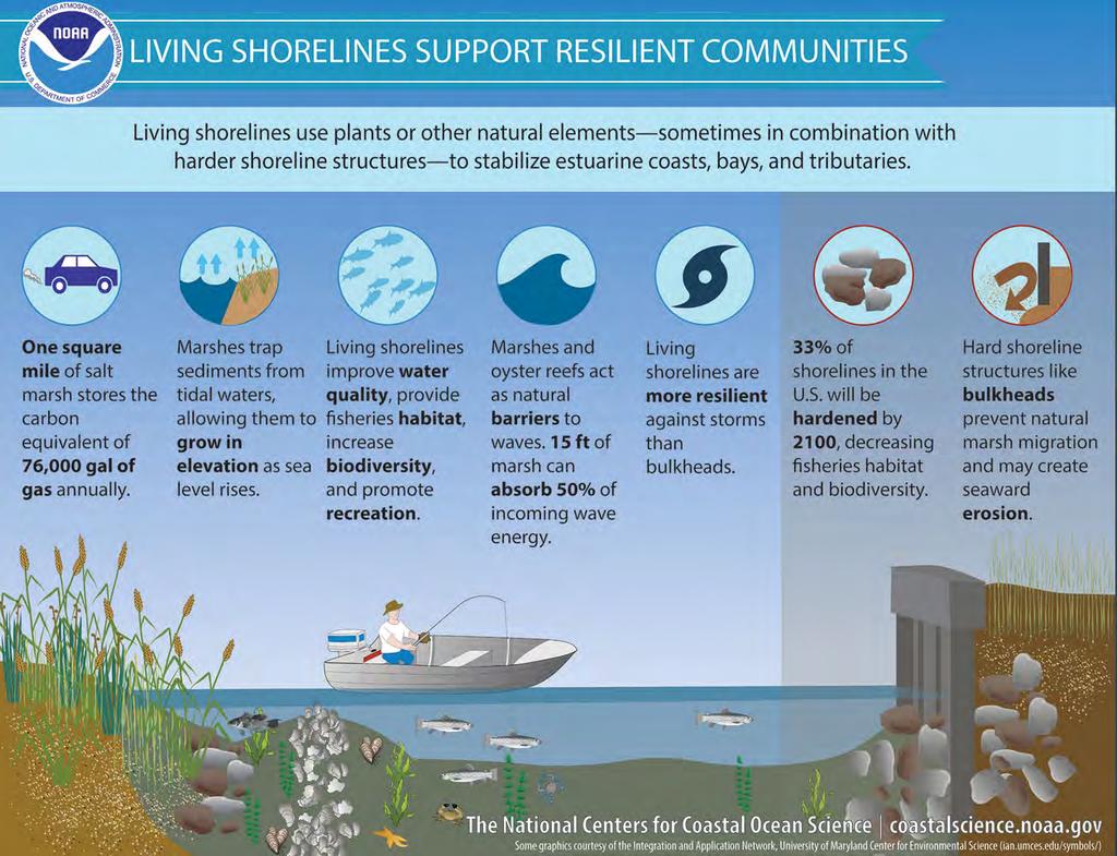
9 Living Shoreline Installations = Natural Green Infrastructure Alternatives or enhancements to bulkheads, seawalls, or revetments Introduction of a naturalized edge using plants, sand/soil, and the limited use of hard structures BENEFITS: Stabilizing the shoreline more resistant to erosion Reducing wave action with natural barriers Protecting surrounding riparian and intertidal environment Improving water quality via filtration of upland run-off Creating habitat for aquatic and terrestrial species
10

11 CZM Grant 1 The PROCESS 1. Municipal Shoreline Survey 2. Identify up to 10 possible sites 3. Chose 3 sites 4. Develop 3 Conceptual Designs

12 Created a Matrix to Determine Site Priority
13 28 Salem Municipal Site Profiles

14 Salem Shoreline Experiencing Erosion

15 Other Places Fringing Salt Marsh Stable

16 Forest River Park future site of Living Shoreline? Ocean Side of City s Swimming Pool 6 patches of salt marsh all behind boulders or bedrock
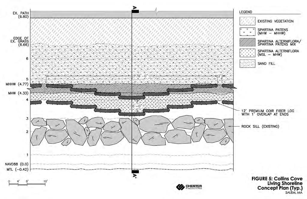
17 Conceptual Designs for 3 Living Shoreline Projects chose 2 of the 4 general Focus Areas 1. Bio-engineering with biodegradable materials and plantings 2. Fringing salt marsh 15 feet of marsh can absorb 50% of incoming wave energy NOT 1. Natural oyster or mussel reef 2. Beach, berm & dune

18 CZM StormSmart Properties Fact Sheet 4: Bioengineering - Coir Rolls on Coastal Banks


19 Clean Up at Lead Mills Salem & Marblehead


20 Living Shoreline Installations Delaware Estuary Living Shoreline Initiative science-and-research/livingshorelines/delsi-tactic/ DelawareEstuary.org

21 Collins Cove Selected as 1 of the 3 Priority Sites Awarded 2 nd Massachusetts Coastal Zone Management Coastal Resilience Grant for design and permitting of Collins Cove
22 Salem s PROCESS with a CZM Green Infrastructure for Coastal Resilience Grant Phase 1 1. Municipal Shoreline Survey 2. Identify up to 10 possible sites 3. Chose 3 sites 4. Develop 3 Conceptual Designs Phase 2 Engineered design + permitting $$,$$$ Phase 3 Implementation of Living Shoreline $$$,$$$
23 Stakeholder Engagement Meetings Making an ESRI Story Map


24 Looking at Collins Cove Past Shallop Cove c : There are a few dozen houses along the Cove. A creek ran from the Salem Common along present-day Forrester Street to the Cove. 1800: The Common is leveled and drained. The creek begins to disappear Salem Map of Collins Cove 1815 (June 17): The Essex Register notes that the Shallop Cove is continually filling up. Great changes have taken place in the memory of the present generation and very great from the first settlement of the town. It was at first their principal place for their Shallops; it is now without water at every fall of the tide. A Shallop from a illustration by Ray Brown in "The Story of Our Merchant Marine" by Willis J. Abbot, 1919.


25 Filling of Collins Cove railroads and sewerage 1815 (June 17): The Essex Register continues: Towards East Street, it is daily filling, from the sluices which conduct the water from the streets into it. The continuation of Webb Street into East Street was formerly the only pass which the town had to the Neck, till it was washed into the cove, by the action of the tide upon its banks Filling continues for Railroad 1874 Map of the City of Salem Map - H. F. Walling - cropped 1820 Salem Map of Collins Cove : The Essex Railroad builds a track across the bottom of the Cove, using gravel brought in from Danvers.
 1889-1890: Salem Board of Health in its annual report declares the Webb Street Basin (the water body between the shoreline and the rail line) a")
26 Sewerage is a Public Nuisance : Sewers are built. All empty into Collins Cove. (Salem City Documents, Street Commissioner s Reports) : Salem Board of Health in its annual report declares the Webb Street Basin (the water body between the shoreline and the rail line) a sanitary nuisance. In 1889, the Board reports that About 8000 cubic yards of gravel have been placed here by the [Boston and Maine] railroad, and some 600 loads of gravel, loam and other suitable filling exclusive of city ashes have been dumped here. Fill work is completed the following year. This adds the land on the present-day odd side of Webb Street Salem and Lynn Harbors, US Coast Survey - cropped c : The rail line is removed : The Collins Cove Playground, a WPA project, is planned and completed. c : City property along Almshouse Road and Fort Avenue is used for a city dump. In 1940 the city completes acquisition of privately held flats next to the dump. The WPA thickens the neck by filling in a roughly triangular area bounded by Almshouse Road and Fort Avenue. They begin a sea wall on its edge, but MA WPA programs are terminated before the wall is completed.


27 Collins Cove Today walking and bike path along the water 1. Municipally owned and actively use by Salem residents 2. Bike and walking path eroding from wave action and continually needing repair 3. Borders a row of houses and Webb Street important road for SESD and Power Plant 4. Filled tideland with lots of gravel deposited since 1800 s

28 Collins Cove Average tide

29 Collins Cove After 11.8ft. King Tide on 11/16/2016


30 Collins Cove During hurricane Sandy 10/29/2012 Nothing like Scituate

31 Collins Cove Spartina alterniflora and other salt marsh plants growing there now
 Spartina patens (salt meadow cordgrass) and other salt marsh plants growing")
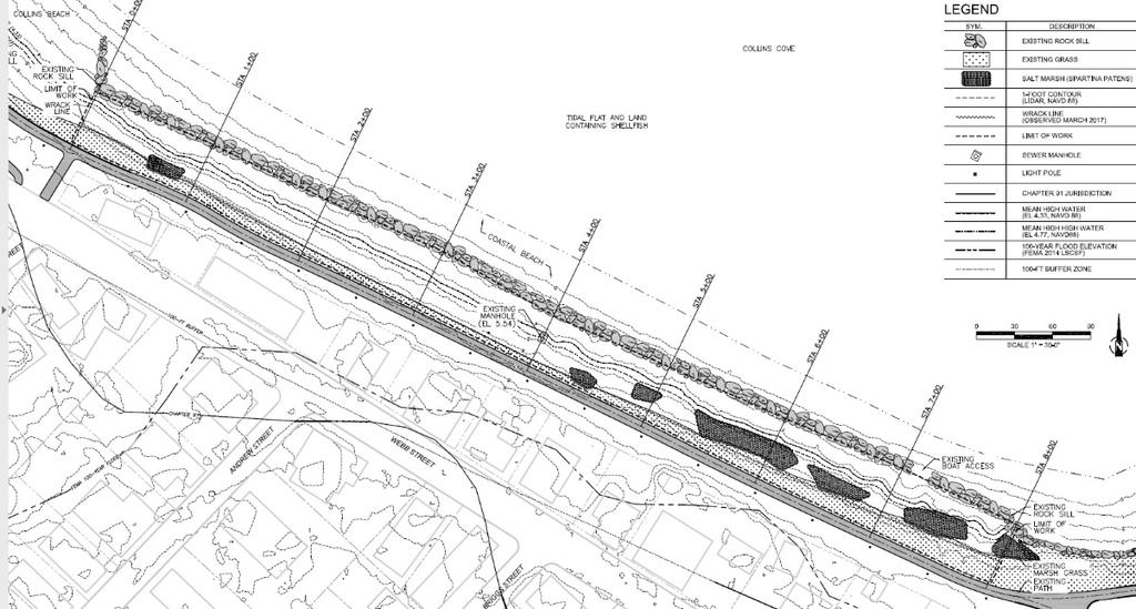
32 Existing Conditions Collins Cove, Salem EXISTING VEGETATION Limonium nashii (sea lavender) Spartina patens (salt meadow cordgrass) and other salt marsh plants growing there now
, partnering with the National Geodetic")

 derived from GPS observations, local tidal datums, and")
33 Marsh Analysis and Planning Tool Incorporating Tides and Elevations MAPTITE NOAA s Center for Operational Oceanographic Products and Services (CO-OPS), partnering with the National Geodetic Survey (NGS) and the National Centers for Coastal Ocean Science (NCCOS), developed an ArcGIS add-in tool MAPTITE for coastal restoration planning. MAPTITE aids in the selection of vegetation types for different restoration elevations based on a combination of a digital elevation model (DEM) derived from GPS observations, local tidal datums, and grass species tolerances.

34 Building a Living Shoreline Using bio-engineering with biodegradable materials and plantings, living shoreline will trap sediment and decrease erosion at low-moderate energy sites. DelawareEstuary.org
35 Permitting Process for a Living Shoreline Project 1. Wetland Delineation Living shoreline demonstration is not in the DEP wetlands regs Limited restoration project is not for shoreline protection or adaptation ~~~~~~~~~~~~~~~~~~~~~~~~~~~~~~~~~~~~~~~~~~~~~~~~~~~~~~~~~~ Must identify all resource areas: beach, salt marsh, coastal bank, etc. Must address performance standards for each under the WPA and coastal regs No Adverse Effect: no increase in erosion no decrease in volume or changing form of beach or downdrift i.e. cannot have loss of structure Clarify what is being altered and get it right the first time Need to Thread the Needle

36 Need Actual Survey of Site - Elevations
37 Wetland Delineation
38 Permitting a Living Shoreline Project MEPA ENF new fill in the v-zone! And other thresholds: alteration of more than half an acre. MA Conservation Commission and DEP WPA, NOI U.S. Army Corps General Permit has a designation for ecological enhancement and shoreline stabilization without rock Chapter 91 license WATER-DEPENDENT Chapter 91 project does not automatically trigger MEPA 401 water quality certification (Section 401 of the federal Clean Water Act)
39 Coir Logs Stabilize Marsh Plantings Collins Cove, Salem
40 Engineering Plans

41 Existing Conditions Collins Cove, Salem STA 8+00 (LOOKING NORTH)

42 Summary - Existing Conditions Collins Cove, Salem VIEW LOOKING WEST

43 Creating a Living Shoreline with green infrastructure Potential to be a 20-foot wide Fringing Salt Marsh 15 feet of marsh can absorb 50% of incoming wave energy VIEW LOOKING WEST Photo Rendering
44 Maintenance and Monitoring Makes SENSE to have a monitoring and maintenance plan Think about HOW this will be done and WHO


45 Questions and Comments Contacts: Tom Devine / City of Salem Department of Planning & Community Development Senior Planner Barbara Warren Salem Sound Coastwatch Executive Director & MassBays Lower North Regional Service Provider


46 Other 2 Priority Sites Furlong Park along the North River Juniper Cove along Columbus Avenue
EEA Capital Investment in Green Infrastructure
 EEA Capital Investment in Green Infrastructure Goal: Advance local efforts to implement measures to increase natural storm damage protection, flood control, and community resilience State capital funding
Empowering Local Action for Coastal Resilience in Massachusetts. Bruce K. Carlisle MA Office of Coastal Zone Management
 Empowering Local Action for Coastal Resilience in Massachusetts Bruce K. Carlisle MA Office of Coastal Zone Management Context Coastal communities continue to face both chronic and acute storm surge, erosion,
NJ Department of Environmental Protection
 NJ Department of Environmental Protection COASTAL AND LAND USE PLANNING New Jersey Coastal Management Program Covers NJ coastal waters to limit of tidal influence including 239 municipalities in 19 counties,
Introducing Green Infrastructure for Coastal Resilience
 Introducing Green Infrastructure for Coastal Resilience National Oceanic and Atmospheric Administration (NOAA) Office for Coastal Management Gloucester, MA Office of Travel Courtesy, Tim Grafft What Is
Planning for Staten. Habitat Restoration and Green Infrastructure. Island s North Shore
 Habitat Restoration and Green Infrastructure Planning for Staten Island s North Shore Community Board 1 March 1, 2018 NYC Parks Forestry, Horticulture, and Natural Resources Funded by the NYS Department
NORTH KINGSTOWN PILOT PROJECT May 9, 2016 North Kingstown Town Council
 Engaging RI Local Governments in Hazard Mitigation and Coastal Resilience NORTH KINGSTOWN PILOT PROJECT May 9, 2016 North Kingstown Town Council Teresa A. Crean, AICP University of Rhode Island Coastal
Green or Grey Solutions? Why not both? Lessons from the Mid-Atlantic on Hybrid Living Shorelines
 Green or Grey Solutions? Why not both? Lessons from the Mid-Atlantic on Hybrid Living Shorelines Proactive By Design. Our Company Commitment Jesse Baldwin Coastal Geologist Project Manager GZA GeoEnvironmental,
Coastal Erosion Commission: context, examples, and next steps
 Coastal Erosion Commission: context, examples, and next steps Overview Themes from other national and state level reports 2007 MA Coastal Hazards Commission Best practices and examples Financial i and
Environmental Consulting & Restoration, LLC Specializing in Wetland and Coastal Resource Area Delineation & Permitting
 Brad Holmes, Manager Professional Wetlands Scientist & Massachusetts Certified Arborist ECR is a small environmental consulting firm specializing in wetland and coastal project permitting and resource
North Carolina Coastal Federation
 North Carolina Coastal Federation Erosion Control: Non-Structural Alternatives A Shorefront Property Owner s Guide Shoreline erosion and landward migration of marshes are natural processes, and are important
Hunts Point Landing, Bronx, New York
 Hunts Point Landing, Bronx, New York Sustainable Shorelines in an Urban Environment John Roebig, PhD. HDR Engineering, Inc. John.Roebig@hdrinc.com Promoting Resilient Shorelines along the Hudson River
State of the State New Jersey. Steve Jacobus NJDEP 06/10/15
 State of the State New Jersey Steve Jacobus NJDEP 06/10/15 1980s Living shorelines term coined in MD 2003 North Carolina passes Living Shoreline Law (HB 1028) early 2000s Delaware puts no bulkhead policy
Introduction. Integrating Ecological Restoration of Estuarine Shorelines with Urban Community Revitalization Efforts. Ed Morgereth Biohabitats, Inc.
 Introduction Integrating Ecological Restoration of Estuarine Shorelines with Urban Community Revitalization Efforts Ed Morgereth Biohabitats, Inc. 5 th National Conference & Expo on Coastal and Estuarine
ALTERNATIVE SHORELINE MANAGEMENT IN COASTAL MISSISSIPPI
 ALTERNATIVE SHORELINE MANAGEMENT IN COASTAL MISSISSIPPI Project supported via financial assistance provided by the Coastal Zone Management Act of 1972, as amended, administered by the Office of the Ocean
Karen A. Duhring Marine Advisory Scientist Center for Coastal Resources Management Virginia Institute of Marine Science College of William & Mary
 Karen A. Duhring Marine Advisory Scientist Center for Coastal Resources Management Virginia Institute of Marine Science College of William & Mary March 20, 2009 Low-Impact Shoreline Stabilization Cumulative
Appendix to Amicus Curiae Brief: Selected Provisions of the South Carolina Beachfront Management Act
 Loyola Marymount University and Loyola Law School Digital Commons at Loyola Marymount University and Loyola Law School Loyola of Los Angeles Law Review Law Reviews 6-1-1992 Appendix to Amicus Curiae Brief:
Lynn Waterfront Master Plan
 Lynn Waterfront Master Plan Public Meeting #2 December 10th, 2018 1 Project Schedule Update September 26, 2018 December 10, 2018 Development of the Master Harbor Plan Amendment and Revised Waterfront Master
Restoring Water Ecosystems in NYC Parks
 Restoring Water Ecosystems in NYC Parks Hooked on our Waters Con October 19, 2013 - CUNY Graduate Center Marit Larson NYC Parks Landscape and ecosystem focus Watershed Streams Freshwater wetlands Tidal
An Integrated Approach for Water Management Examples from The Netherlands. Addressing Climate Change and Sea Level Rise
 An Integrated Approach for Water Management Examples from The Netherlands Addressing Climate Change and Sea Level Rise Superstorm Sandy Forum College of Staten Island March 8 2013 Water: a challenge and
Brooklyn Bridge Park: Storm Resilience through Design
 Brooklyn Bridge Park: Storm Resilience through Design During the early stages of the Brooklyn Bridge Park design process, careful thought was given to shoreline conditions and site location. Due to BBP
Executive Office of Energy and Environmental Affairs Massachusetts Vulnerability Preparedness Program. June 6, 2018
 Executive Office of Energy and Environmental Affairs Massachusetts Vulnerability Preparedness Program June 6, 2018 Presentation Outline: 1. What Natural Hazards Impact Falmouth 2. Coastal Resiliency Efforts
CONSERVATION ELEMENT GOALS, OBJECTIVES, AND POLICIES
 CONSERVATION ELEMENT GOALS, OBJECTIVES, AND POLICIES Goal 4 To conserve, manage, appropriately use and protect the natural resources of the City ensuring continued resource availability and environmental
Coastal Planning in Texas. Tony Williams Senior Director of Planning Coastal Resources Division Texas General Land Office
 Coastal Planning in Texas Tony Williams Senior Director of Planning Coastal Resources Division Texas General Land Office e The Texas General Land Office (GLO) and the Texas Coast Since 1836: Manager of
Nature-Based Adaptation Projects Challenges and Opportunities in California Marilyn Latta, Project Manager California State Coastal Conservancy
 Nature-Based Adaptation Projects Challenges and Opportunities in California Marilyn Latta, Project Manager California State Coastal Conservancy Restore America s Estuaries California State Coastal Conservancy
Getting to Resilience webinar
 Getting to Resilience webinar A brief description of two NJDEP Projects: Resilient Coastal Communities Initiative & Municipal Public Access & Resiliency Small Grants Program June 26, 2014 Marty Rosen NJ
EXHIBIT A CITY OF FORT WALTON BEACH, FLORIDA COASTAL MANAGEMENT & CONSERVATION
 EXHIBIT A CITY OF FORT WALTON BEACH, FLORIDA INTRODUCTION The Coastal Management and the Conservation Elements required by Chapter 9J-5.012 and 5.013, F.A.C., respectively, have been combined into one
COASTAL MANAGEMENT ELEMENT. Last amended December 6, 2016 as part of the 2016 EAR
 COASTAL MANAGEMENT ELEMENT Last amended December 6, 2016 as part of the 2016 EAR Table of Contents Objective Page 7.1 Development and redevelopment of waterfront properties...7-1 7.2 Agency coordination
Building Ecological Solutions to Coastal Community Hazards: Guidance and NJ Coastal Community Assistance
 Building Ecological Solutions to Coastal Community Hazards: Guidance and NJ Coastal Community Assistance Stacy Small-Lorenz National Wildlife Federation Restore America s Estuaries Summit New Orleans,
Introduction to the Seahurst Park Ecosystem Restoration Project: A Process of Transformation. Presented by Peter Hummel, ASLA, LEED AP
 Introduction to the Seahurst Park Ecosystem Restoration Project: Presented by Peter Hummel, ASLA, LEED AP September 16, 2014 Environmental Science Center Public Education Series 0 Acknowledgements Project
Gibsons Foreshore & Seawalk Improvements
 Gibsons Foreshore & Seawalk Improvements Mini-Charrette - Presentation Town of Gibsons October 6, 2016 Our Team Consulting Team Dave Murray, Project Manager, Water Resources Engineer, KWL David Reid, Facilitator,
Virginia s Tidal Wetlands: Managing for Resilience. Pam Mason
 Virginia s Tidal Wetlands: Managing for Resilience Pam Mason Image: Skip Stiles, Wetlands Watch PAST: City of Norfolk shallow water and wetlands Fill. Maersk Nauticus Chrysler Museum Mc Arthur Mall Opera
Planning for Staten. Habitat Restoration and Green Infrastructure. Island s North Shore
 Habitat Restoration and Green Infrastructure Planning for Staten Island s North Shore Walker Park December 7, 2017 NYC Parks Forestry, Horticulture, and Natural Resources Funded by the NYS Department of
FirstLight Power Shoreline Management Manual Sustainable Shoreline Designs: From Long Island to Lake Erie Webinar Series
 FirstLight Power Shoreline Management Manual Sustainable Shoreline Designs: From Long Island to Lake Erie Webinar Series Presented by Jason Williams, PLA, NCI February 19, 2017 Introduction Lakes (impoundments)
Natural & Nature-Based Solutions for Risk Reduction & Resilience
 University of Massachusetts Amherst ScholarWorks@UMass Amherst International Conference on Engineering and Ecohydrology for Fish Passage International Conference on Engineering and Ecohydrology for Fish
CHAPTER Committee Substitute for Senate Bill No. 1472
 CHAPTER 2007-99 Committee Substitute for Senate Bill No. 1472 An act relating to beaches and shores; amending s. 161.021, F.S.; amending a definition; amending s. 161.085, F.S.; restricting the use of
Living Shoreline Professionals Advanced Training. August 24 & 31, 2017 Hosted by Virginia Institute of Marine Science College of William & Mary
 Living Shoreline Professionals Advanced Training August 24 & 31, 2017 Hosted by Virginia Institute of Marine Science College of William & Mary LIVING SHORELINE PROFESSIONALS ADVANCED TRAINING AUGUST 2017
The Napa River Flood Protection Project
 The Napa River Flood Protection Project Creating Flood Protection and Restoring Geomorphic and Biological Processes Jeremy Sarrow, Napa County Flood Control & Water Conservation District June 2, 2014.
A. INTRODUCTION B. CUMULATIVE EFFECTS ANALYSIS
 Chapter 4: Cumulative Effects A. INTRODUCTION The New York City Department of Parks and Recreation plans to reconstruct the Rockaway Beach Boardwalk in the borough of Queens, New York City, which Hurricane
Caler Cove Lobster Company
 File No.: 199800920 City and State: Addison, ME Caler Cove Lobster Company General Impacts: 0.17 acre tidal emergent Functions and Values Lost: Production Export Nutrient Exchange Sediment Filtration Fishery
WEATHER IT TOGETHER Building Resilience. The Annapolis Model for Cultural Resource Hazard Mitigation Planning
 WEATHER IT TOGETHER Building Resilience The Annapolis Model for Cultural Resource Hazard Mitigation Planning Weather It Together A Public / Private Partnership Weather It Together is the Annapolis model
Preparing Hudson River Waterfronts for an Era of Rapid Sea Level Rise
 Preparing Hudson River Waterfronts for an Era of Rapid Sea Level Rise CITY OF KINGSTON TIDAL WATERFRONT FLOODING TASK FORCE Gregg Swanzey Director, Office of Economic Development & Strategic Partnerships,
Living Shoreline Fundamentals
 Living Shoreline Fundamentals Karen Duhring Virginia Institute of Marine Science College of William & Mary April 19, 2017 Kilmarnock, VA Living Shoreline Fundamentals Origins of Living Shoreline Initiative
Riparian Buffer on the Bushkill Creek. Policies
 Riparian Buffer on the Bushkill Creek Riparian buffers provide numerous benefits to landowners and the community by protecting groundwater recharge areas, providing flood control, providing stormwater
Monitoring and Maintenance Permit Process
 Karen A. Duhring Marine Advisory Scientist Center for Coastal Resources Management Virginia Institute of Marine Science College of William & Mary April 9, 2010 Living Shorelines for Contractors and Project
Pontchartrain Coastal Lines of Defense Program Figure 1 Figure 2 Figure 1
 Pontchartrain Coastal Lines of Defense Program Coastal Sustainability Program February 2006 The Pontchartrain Coastal Lines of Defense Program consists of ten priority project areas within the Pontchartrain
Baylands Segment J. Bay between the Golden Gate and Segment J. Coyote Point. of For managed ponds. included habitat enhancement.
 Baylands Segment J Crissy Field Alameda Naval Air Station Heron's Head Park COLMA CREEK SFO Millbrae San Mateo BAYLANDS 2009 SAN FRANCISCO AREA san francisco area Western side of central San Francisco
Libby Zemaitis October 18, 2017 Climate Outreach Specialist, NYS DEC Hudson River Estuary Program
 1 Supporting Hudson Riverfront communities as Climate-Adaptive Leaders Libby Zemaitis October 18, 2017 Climate Outreach Specialist, NYS DEC Hudson River Estuary Program The Hudson River Estuary Program
April 11, 2016 Park Board Chair and Commissioners General Manager Vancouver Board of Parks and Recreation New Brighton Salt Marsh - Preferred Concept
 TO: FROM: SUBJECT: April 11, 2016 Park Board Chair and Commissioners General Manager Vancouver Board of Parks and Recreation New Brighton Salt Marsh - Preferred Concept RECOMMENDATION A. THAT the Vancouver
ORDINANCE NO
 ORDINANCE NO. 9048-17 AN ORDINANCE OF THE CITY OF CLEARWATER (THE CITY), FLORIDA, MAKING AMENDMENTS TO THE CITY S COMPREHENSIVE PLAN IN ACCORDANCE WITH FLORIDA SENATE BILL 1094 (2015) PERIL OF FLOOD ACT
New Brighton Park Shoreline Habitat Restoration Project
 Vancouver Board of Parks and Recreation and Port Metro Vancouver New Brighton Park Shoreline Habitat Restoration Project Conceptual Design Public Consultation August 26 September 9, 2015 Discussion Paper
Options for Managing Coastal Erosion. Presentation by: Ashley Sprague
 Options for Managing Coastal Erosion Presentation by: Ashley Sprague Shoreline stabilization methods Armouring - Boulders/rockwalls most common method of erosion control in Nova Scotia Concerns: - Accelerate
Master Plan for Preservation and Scenic Conservation (1995)
") 3.2 Master Plan for Preservation and Scenic Conservation (1995) The Master Plan for Preservation and Scenic Conservation was developed under the direction of the Guilford Preservation Alliance in the 1980s
3.2 Master Plan for Preservation and Scenic Conservation (1995) The Master Plan for Preservation and Scenic Conservation was developed under the direction of the Guilford Preservation Alliance in the 1980s
Kevin M. Rampe, President -- Lower Manhattan Development Corporation
 For Internal Use Only: Date Received: WRP no. DOS no. NEW YORK CITY WATERFRONT REVITALIZATION PROGRAM Consistency Assessment Form Proposed actions that are subject to CEQR, ULURP or other local, state
Bristol Marsh Heritage Conservancy
 Bristol Marsh Heritage Conservancy The Pennsylvania Environmental Council (PEC) protects and restores the natural and built environments through innovation, collaboration, education and advocacy. PEC believes
Natural Resource Adaptation Action Area Addressing Sea Level Rise in Estuarine Ecosystems TO: TOWN OF YANKEETOWN MAY
 Natural Resource Adaptation Action Area Addressing Sea Level Rise in Estuarine Ecosystems TO: TOWN OF YANKEETOWN MAY 6 2013 University of Florida Conservation Clinic Vivek Babbar, Student Associate, J.D.
Mitigation + Adaptation Strategies for Historic Structures and Sites
 Mitigation + Adaptation Strategies for Historic Structures and Sites Adrienne Burke, Esq., MSAS, LEED AP+ Executive Director, Riverside Avondale Preservation, Jacksonville, FL Cultural Resources, Disaster
Funding, Designing, and (eventually) Building Miles of Shoreline and Acres of Wetlands and Oyster Reefs on an Urbanized River!
 Building Miles of Shoreline and Acres of Wetlands and Oyster Reefs on an Urbanized River!") CW Gaskill City of Norfolk Funding, Designing, and (eventually) Building Miles of Shoreline and Acres of Wetlands and Oyster Reefs on an Urbanized River! Don Cole Brown and Caldwell C. W. Gaskill City
CW Gaskill City of Norfolk Funding, Designing, and (eventually) Building Miles of Shoreline and Acres of Wetlands and Oyster Reefs on an Urbanized River! Don Cole Brown and Caldwell C. W. Gaskill City
COASTAL MANAGEMENT ELEMENT GOALS, OBJECTIVES, AND POLICIES
 COASTAL MANAGEMENT ELEMENT GOALS, OBJECTIVES, AND POLICIES Goal 5 The City shall protect human life and limit public expenditure in areas subject to destruction by natural disasters and, where appropriate,
Stream Restoration: Working with Nature?
 Stream Restoration: Working with Nature? Greg Jennings, PhD, PE jenningsenv@gmail.com Ecosystem Restoration activities that initiate or accelerate the recovery of ecosystem health, integrity, and sustainability
Stream Restoration: Working with Nature? Greg Jennings, PhD, PE
 Stream Restoration: Working with Nature? Greg Jennings, PhD, PE jenningsenv@gmail.com Ecosystem Restoration activities that initiate or accelerate the recovery of ecosystem health, integrity, and sustainability
Weston s Wetlands, Stormwater, & Open Space
 Weston s Wetlands, Stormwater, & Open Space Weston s Wetlands, Stormwater, & Open Space Conservation Commission Role and Responsibilities Laws that protect wetlands What residents can do to protect wetlands
RECREATION, OPEN SPACE AND GREENWAYS ELEMENT GOALS, OBJECTIVES, AND POLICIES
 RECREATION, OPEN SPACE AND GREENWAYS ELEMENT GOALS, OBJECTIVES, AND POLICIES GOAL R-1: DEVELOP A RECREATION, OPEN SPACE AND GREENWAYS SYSTEM AS AN INTEGRAL COMPONENT OF AN OVERALL, COUNTY-WIDE ECONOMIC
Sierra Club Comments on ACOE Public Notice NAE Re: Proposed Town Neck Beach Project at Sandwich, Massachusetts
 August 27, 2015 US Army Corps of Engineers New England District 696 Virginia Road Concord, MA 01742-2751 Attn: Phillip W. Nimeskern Dear Mr. Nimeskern, Sierra Club Comments on ACOE Public Notice NAE-2014-259
New York City, 19 th c.
 New York City, 19 th c. Lower Manhattan, circa 1930s Westside Highway, Manhattan, circa 1940s Greenpoint Terminal Market, Brooklyn TRANSFORMATIONS ON THE WATERFRONT Harlem River Park, Manhattan BEFORE
Request for Proposals
 Request for Proposals Charlestown Navy Yard Infrastructure Assessment Engineering Services The Boston Redevelopment Authority ( BRA )/Economic Development Industrial Corporation ( EDIC ) is issuing a Request
July 22, 2013 REQUEST FOR PROPOSALS TO PROVIDE ENGINEERING DESIGN SERVICES FOR A PROJECT ALONG THE WESTERN SHORE OF MOBILE BAY
 Mobile Bay National Estuary Program 4172 Commanders Drive Mobile, AL 36615 Phone: 251-431-6409 Fax: 251-431-6450 Contact: Tom Herder, Watershed Protection Coordinator Email: therder@mobilebaynep.com July
Cohasset Municipal Harbor Plan Public Meeting #1. Harriman GEI Consultants FXM Associates May 31, 2018
 Public Meeting #1 Harriman GEI Consultants FXM Associates Agenda Welcome and Introductions Planning Study: Purpose and Process Municipal Harbor Planning 101 Existing Conditions Creating a Vision for the
OLD BUSINESS NEW BUSINESS A. JIM CONWAY 2016-WTRA B. KENNETH CALISE 2016-WTRA C. SAGIE DORON 2016-WTRA-00060
 May 12, 2016 TO: Wetlands Board Members FROM: Richard W. Scarper RE: May, 2016 Wetlands Board Applications Attached are the Planning Department's administrative comments for the following wetlands/dunes
ME DOT Route 3. File No.: City and State: Bar Harbor, ME
 ME DOT Route 3 File No.: 199600361 City and State: Bar Harbor, ME General Impacts: 0.28 acre tidal emergent 0.77 acre non-tidal forested 0.15 acre non-tidal emergent 0.51 acre non-tidal scrub-shrub Functions
Tentatively Selected Plan within Harlem River, East River and Western Long Island Sound Planning Region. First Level Costs. Federal Non-Federal Total
 HARLEM RIVER, EAST RIVER AND WESTERN LONG ISLAND SOUND PLANNING REGION Flushing Bay and Creek Ecosystem Restoration Source Feasibility Study Background Study Resolution (1994), Reconnaissance Report (1996),
East Midtown Greenway
 East Midtown Greenway 53RD TO 61ST STREET Interpretive Signage Package CB6 Meeting 61st St 60th St FDR Drive East Midtown 59th St 58th St 57th St Ed Koch Queensboro Bridge Manhattan Queens Second Avenue
RESPONSES TO PUBLIC CONCERNS AND QUESTIONS
 RESPONSES TO PUBLIC CONCERNS AND QUESTIONS Stations and Summary Questions for Public Meeting #2 June 23, 2015 General Questions / Concerns: 1. Is there any way this development can raise revenue for the
Introduction to the Shoreline Master Program (SMP) Update. City of Bellingham Planning Department 2005
 Update. City of Bellingham Planning Department 2005") Introduction to the Shoreline Master Program (SMP) Update City of Bellingham Planning Department 2005 Purpose of tonight s meeting: Specify which water-bodies are subject to the SMP. Identify the State
Introduction to the Shoreline Master Program (SMP) Update City of Bellingham Planning Department 2005 Purpose of tonight s meeting: Specify which water-bodies are subject to the SMP. Identify the State
Rhode Island Shoreline Change Special Area Management Plan
 Rhode Island Shoreline Change Special Area Management Plan Draft Document Outline REVISED 10/12/2017 VOLUME 1 Executive Summary & How to Use this Document (Draft by Dec 2017) 1. Introduction (Revised draft
Preliminary Sea Level Rise Case Study: Navarre Beach, FL
 Preliminary Sea Level Rise Case Study: Navarre Beach, FL This publication was funded in part, through a grant agreement from the Florida Department of Environmental Protection, Florida Coastal Management
CHAPTER ONE INTRODUCTION
 1.0 Introduction Bellingham s central waterfront is in a state of transition from its long history as an active industrial site to a new mixed-use neighborhood. Over the past several years, the Port of
STREAM BANK STABILIZATION THORPS MORTIMER RECREATION AREA Grandfather Ranger District SITE LOCATION & DRAINAGE AREA
 STREAM BANK STABILIZATION THORPS CREEK @ MORTIMER RECREATION AREA SITE LOCATION & DRAINAGE AREA SITE LOCATION Drainage Area = 1.14 sq. miles STREAM BANK STABILIZATION THORPS CREEK @ MORTIMER RECREATION
Welcome. Tannery and Waterworks Parks Shoreline Improvements Environmental Assessment. Public Information Centre #1 November 27, pm to 8 pm
 Welcome Tannery and Waterworks Parks Shoreline Improvements, Environmental Assessment Tannery and Waterworks Parks Shoreline Improvements Environmental Assessment #1 6 pm to 8 pm Why We Are Here Tannery
Use of Best Management Practices
 Use of Best Management Practices Presented at the ANJEC Flood Hazard Workshop Bordentown, NJ March 13, 2008 Stormwater BMPs "a technique, measure or structural control that is used for a given set of conditions
BASS PONDS, MARSH, & WETLAND HABITAT RESTORATION PROJECT
 FACT SHEET BASS PONDS, MARSH, & WETLAND HABITAT RESTORATION PROJECT MINNESOTA VALLEY NATIONAL WILDLIFE REFUGE, MINNESOTA ENVIRONMENTAL MANAGEMENT PROGRAM LOCATION Three areas located on the Minnesota Valley
Improvement of the Atlantic Coast of New York City,
 Improvement of the Atlantic Coast of New York City, Rockaway Inlet to Norton Point Project at Sea Gate Meeting Purpose The U.S. Army Corps of Engineers, the New York State Department of Environmental Conservation,
Billing Code: DEPARTMENT OF HOUSING AND URBAN DEVELOPMENT [Docket No. FR-6072-N-01]
![Billing Code: DEPARTMENT OF HOUSING AND URBAN DEVELOPMENT [Docket No. FR-6072-N-01]](/thumbs/91/107309814.jpg "Billing Code: DEPARTMENT OF HOUSING AND URBAN DEVELOPMENT [Docket No. FR-6072-N-01]") This document is scheduled to be published in the Federal Register on 12/18/2017 and available online at https://federalregister.gov/d/2017-27194, and on FDsys.gov Billing Code: 4210-67 DEPARTMENT OF HOUSING
This document is scheduled to be published in the Federal Register on 12/18/2017 and available online at https://federalregister.gov/d/2017-27194, and on FDsys.gov Billing Code: 4210-67 DEPARTMENT OF HOUSING
Tale of Two Cities: Exploring How Two Communities are Using Green Infrastructure to Reduce Flood Risk
 Tale of Two Cities: Exploring How Two Communities are Using Green Infrastructure to Reduce Flood Risk NACo Steering Subcommittees Education Session Lori Cary-Kothera NOAA Coastal Services Center Issue
5 TH ANNUAL CAPE COASTAL CONFERENCE
 5 TH ANNUAL CAPE COASTAL CONFERENCE Key Considerations for Living Shoreline Projects Seth Wilkinson, Restoration Ecologist, President Wilkinson Ecological Design, Inc. BIOENGINEERING STRATEGIES Reducing
Folly Beach Planning Commission
 Folly Beach Planning Commission June 4, 2018 6:00 PM WORK SESSION 7:00 PM REGULAR MEETING ---------------------------------------------------------------------------------------------------- Commission
Natural Infrastructure for Coastal Resilience Unlocking Funding Resources
 Natural Infrastructure for Coastal Resilience Unlocking Funding Resources Siddharth Narayan University of California Santa Cruz / The Nature Conservancy Financing Climate- Safe, Resilient Infrastructure
Landscape Conservation Design April, 2014
 Designing Sustainable Landscapes in the Northeast A project of the North Atlantic Landscape Conservation Cooperative & Northeast Climate Science Center Landscape Conservation Design April, 2014 Conceptual
water resource specialists
 Vaughn Collins, PE, CFM, Northwest Hydraulic Consultants Brad Livingston, Oregon Department of Transportation Melissa Reich, North Coast Land Conservancy Location Necanicum River 75 sq mi watershed Active
Ottawa County Parks, Recreation & Open Space Plan. February, 2006
 2006 Ottawa County Parks, Recreation & Open Space Plan February, 2006 TABLE OF CONTENTS ACKNOWLEDGMENTS.................................................... v PLAN ADOPTION..........................................................vi
10.0 Open Space and Public Realm
 10.0 Open Space and Public Realm 10.0 Open Space and Public Realm The Public Open Space System is comprised of: outdoor spaces available for public use that are either publicly owned (e.g., parks and
QUESTIONS AND ANSWERS Windsor Woods, Princess Anne Plaza & The Lakes Combined Drainage Project
 QUESTIONS AND ANSWERS Windsor Woods, Princess Anne Plaza & The Lakes Combined Drainage Project PROJECT OVERVIEW Windsor Woods, Princess Anne Plaza and The Lakes are neighborhoods located in what was once
Living Shorelines in Virginia: What s Happened Since the 2006 Living Shorelines Summit?
 Living Shorelines in Virginia: What s Happened Since the 2006 Living Shorelines Summit? Karen Duhring Center for Coastal Resources Management Virginia Institute of Marine Science College of William & Mary
Wetlands Board Hearing Procedures
 Wetlands Board Hearing Procedures The Virginia Beach Wetlands Public Hearing is held at 10:00am in the Council Chamber of the City Hall Building, Municipal Center. A staff briefing is held at 8:30am a.m.
QUESTIONS AND ANSWERS Windsor Woods, Princess Anne Plaza & The Lakes Combined Drainage Project
 QUESTIONS AND ANSWERS Windsor Woods, Princess Anne Plaza & The Lakes Combined Drainage Project Project Overview... 2 Thalia Creek (Windsor Woods) Tide Gate... 6 Club House Road Drainage Project... 9 Updated
.MANAGED RETREAT. Need for managed retreat
 602 MANAGED RETREAT hazards. This strategy is based on a philosophy of moving out of harm's way, and is proactive in recognizing that the dynamics of the coastal zone should dictate the type of management
Cherry Beach Shoreline Protection Infrastructure Conceptual Design and Class EA
 Welcome Cherry Beach Shoreline Protection Infrastructure Conceptual Design and Class EA May 3, 2012 Study Area Cherry Beach neighbourhood is located in lower Stoney Creek on Lake Ontario, east of Millen
2013 Summer Recap. Rockaway Beach
 2013 Summer Recap and Discussion on Rockaway Beach Reconstruction Tonight s Agenda Summer Beach Update Phase 2 Assumptions, Constraints and Regulations Rebuilding the Boardwalk Coastal Protection Rockaway
RESILIENCY, ADAPTATION, & SUSTAINABILITY AT THE CITY OF ST. AUGUSTINE
 RESILIENCY, ADAPTATION, & SUSTAINABILITY AT THE CITY OF ST. AUGUSTINE PROGRAM UPDATE JANUARY 14, 2019 MICHAEL G. CULLUM, P.E. DIRECTOR, PUBLIC WORKS PROGRESSION OF PLANNING FOR RESILIENCY / ADAPTATION
Staff will be providing an overview of the project need, purpose and intent for consideration as part of the Amendment cycle.
 Agenda Item D-2 City of Tacoma Planning and Development Services To: Planning Commission From: Stephen Atkinson, Planning Services Division Subject: Open Space Corridors Project Meeting Date: March 1,
Coastal Construction Setback Line Review
 City of New Smyrna Beach City Council Meeting January 23, 2018 Scope of Work Comparison of the City's Coastal Construction Setback Line (CCSL) to that of the Florida Department of Environmental Protection