Public Meeting Simpson Bay Area
|
|
|
- Harvey Gaines
- 6 years ago
- Views:
Transcription

1 afbeelding plaatsen op dit grijze vlak (of vraag Jolanda/ Edwin om een mooie plaat) tip drawing lines aanzetten (linksonder draw ; grid and guides ; display drawing guides on screen. Public Meeting Simpson Bay Area Development Plan Sint Maarten March 2012

2 Why a development plan?
3 What area?

4 Main functions Simpson Bay Lagoon

5

6 Airport Road

7 Fishery restaurants along the Lagoon

8 Housing in Simpson Bay Village


9 Monuments in Simpson Bay Village

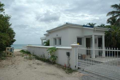
10 Housing on Beacon Hill

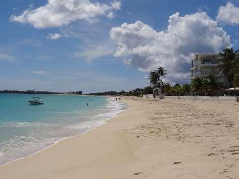
11 Smaller hotels along the beach

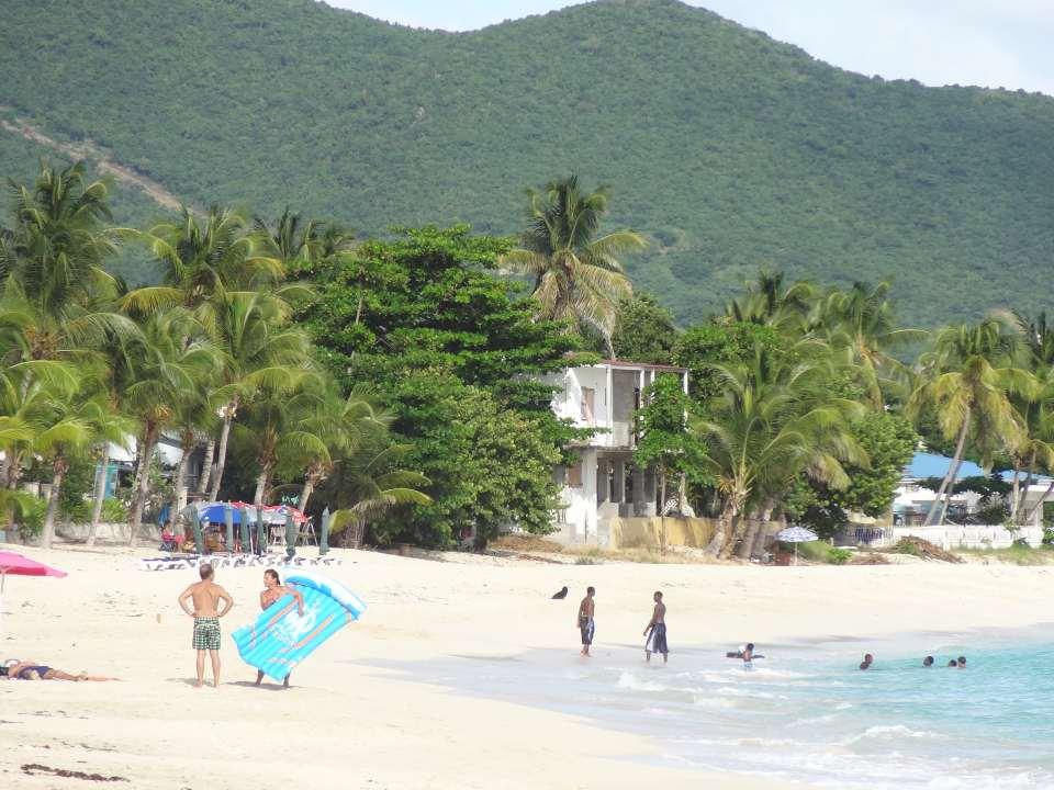
12 Tourism in Simpson Bay
13 Foto

14 Impressions

15
16 Issues to discuss A. Infrastructure B. Princess Juliana International Airport C. Tourism and Recreation D. Commercial and Industrial development E. Residential neighborhoods F. Nature and Landscape G. Cultural Heritage and Archaeology
17 Issues to discuss: A. Infrastructure: Congestion + Accessibility B. Princess Juliana International Airport C. Tourism and Recreation D. Commercial and Industrial development E. Residential neighborhoods F. Nature and Landscape G. Cultural Heritage and Archaeology


18 A: Issues Infrastructure Issues: 1. Accessibility / new connections 2. Congestion Airport Road 3. Canal / Draw Bridge

19 Issue 1: Accessibility / new connections

20 Starting point Issue 1a: Link 8 Link 8: possible option - Land reservation for future road connection - Integrate link 8 with land reclamation Simpson Bay - Bypass to Orange Grove Road

21 Starting point Issue 1b: Link 9 Link 9: - Designate planned causeway in Development plan
22 Issue 2: Congestion Airport Road

23 Starting point Issue 2: Redesign Airport Road Where possible: redesign profile of the road special attention to parking and palm trees
24 Issues 3: Canal and Drawbridge


25 Starting point 3: Canal and Drawbridge Accommodate improvement fairway / canal by implementing plans for: canal and / or bridge or tunnel
26 Issues to discuss: A. Infrastructure B. Princess Juliana International Airport: Economic motor of sxm C. Tourism and Recreation D. Commercial and Industrial development E. Residential neighborhoods F. Nature and Landscape G. Cultural Heritage and Archaeology


27 B: Issues PJIA Issues: 4. Safety zone Princess Juliana International Airport 5. Maximum height buildings around PJIA 6. Expansion plans and airport related development

28 Issue 4: Safety zone PJIA
29 Starting point Issue 4: Safety zone Short term: - Strictly enforce existing international regulations Medium long term (20-30 years): - Extend landing strip to required width - In close cooperation with PJIA
30 Issue 5: Maximum height regulations
31 Starting point Issue 5: Maximum height Strictly enforce existing regulations for new developments Both on land and in Lagoon

32 Issue 6: Development plans PJIA
33 Starting point Issue 6 - Implement expansion plans for first phase - Accommodate airport related commercial development
34 Issues to discuss: A. Infrastructure B. Princess Juliana International Airport C. Tourism and Recreation: Guide the development for a sustainable future D. Commercial and Industrial development E. Residential neighborhoods F. Nature and Landscape G. Cultural Heritage and Archaeology
35 C: Issues on Tourism and Recreation Issues: 7. Development coastal zone 8. Boardwalk along lagoon 9. Marina s and land reclamation 10.New pier
36 Issue 7: Development Coastal zone

37 Large developments along the beach


38 Starting point Issue 7 - Designated areas for small hotels and inns - Establish rules for height and size of beachfront development
39 Issue 8: Visilibilty Lagoon: Boardwalks


40 Issue 8 Existing situation: Private property along the Lagoon Example Marigot Lagoon: Public boardwalk with marina facilities


41 Starting point Issue 8 Realize a public boardwalk
42 Issue 9: Marina s and Landreclamations
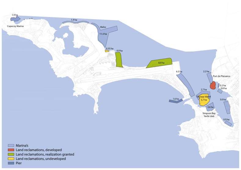


43 Inventory
44 Starting point Issue 9 - Private boat slips allowed except where shoreline is protected - Designate areas for possible new Marina s and land reclamations - Residential use of water?

45 Issue 10: New Pier


46 Possible functions of the new pier


47 Starting point Issue 10 - Reserve space for new pier - Restrict size and height of buildings on pier
48 Issues to discuss: A. Infrastructure B. Princess Juliana International Airport C. Tourism and Recreation D. Commercial and Industrial development: Sustainable development for local economy E. Residential neighborhoods F. Nature and Landscape G. Cultural Heritage and Archaeology
49 D: Issues Commercial and industrial development Issues: 11.Commercial activities in residential neighborhoods 12.Focus on industrial development along airport runway

50 Issue 11: Commercial and Retail functions

51 Starting points Issue 11: Commercial and Retail Airport Road Concentrate commercial services and retail along Airport Road in Simpson Bay Village No bars and restaurants at the beach?
52 Issue 12: Industrial development along runway Present and planned strip along runway Wide variety of functions


53 Starting points Issue 12 1: Implement airport development plan 2: no nonairport related activities 3: focus on airport related services
54 Issues to discuss: A. Infrastructure B. Princess Juliana International Airport C. Tourism and Recreation D. Commercial and Industrial development E. Residential neighborhoods F. Nature and Landscape G. Cultural Heritage and Archaeology
55 E: Issues on Residential Neighborhoods Issues: 13. Development large apartment buildings: Beacon Hill Simpson Bay Village 14. Quality of living environment: Simpson Bay Village
56 Issue 13 Future development of Simpson Bay Village and beach: - Quiet green village with family houses and family beach? - Highrise and busy leisure and entertainment area? - Mixed area with family houses and leisure / hotels? Desired atmosphere requires different rules for height, alignment, boundaries, green etc What does that look like?


57 Discussion Issue 13 Quiet green village with family houses and family beach?


58 Discussion Issue 13 High-rise and busy leisure and entertainment area?


59 Discussion Issue 13 Mixed area with family houses and leisure / hotels?
60 Starting point Issue 13 - Quiet green village with family houses and family beach? - High-rise and busy leisure and entertainment area? - Mixed area with family houses and leisure / hotels?


61 Issue 14: Quality of living environment - Noise of resorts - Drainage of roads - Public space

62 Starting point Issue 14 Attention for public space, neighborhood facilities, water drainage
63 Issues to discuss: A. Infrastructure B. Princess Juliana International Airport C. Tourism and Recreation D. Commercial and Industrial development E. Residential neighborhoods F. Nature and Landscape G. Cultural Heritage and Archaeology
64 F: Issue on Nature and Landscape Issues: 15.Nature value of Mullet Pond, Little Key and the Mangrove shores 16.Turtles breed on the beach
65 Issue 15: Nature and Landscape
66 Starting point Issue 15 Preserve Mullet Pond, Little Key and the Mangrove shores
67 Issue 16: Turtles on the beach


68 Starting point Issue 16 Protect parts of the beach where turtles make nests
69 Issues to discuss: A. Infrastructure B. Princess Juliana International Airport C. Tourism and Recreation D. Commercial and Industrial development E. Residential neighborhoods F. Nature and Landscape G. Cultural Heritage and Archaeology
70 G: Issues on Cultural Heritage Issues: 17.Use of protected monuments and other monumental structures 18.Drives of Simpson Bay Village
71 Issue 17: Monuments

72 Simpson Bay Village 1962


73 Starting point Issue 17 Protection of monuments and other buildings of heritage value by re-using them

74 Issue 18: Drives of Simpson Bay Village


75 Starting point Issue 18: Maintain drives

76 Overview issues:

77 Present situation
Kingston Inner Harbour: A Cultural Heritage Landscape Pilot Study
 Kingston Inner Harbour: A Cultural Heritage Landscape Pilot Study Benjamin L. Holthof A report submitted to the School of Urban and Regional Planning in conformity with the requirements for the degree
Overview of Land Use Framework for Victoria Harbourfront. Planning Department February 2011
 Overview of Land Use Framework for Victoria Harbourfront Planning Department February 2011 Background TPB set out Vision Statement for the Victoria Harbour in 1999 To make Victoria Harbour attractive,
Riverfront Development Plan
 Planning Studies Project Overview: Continuity Developing Fort Myers underused riverfront was the final step in Downtown redevelopment. To mine all facets of the riverfront, the Plan had to be created cohesively
TAHOE CITY VISION PLAN June 2012
 TAHOE CITY VISION PLAN June 2012 Tahoe City Public Utility District North Lake Tahoe Resort Association Sustainable Community Advocates Agenda Process Overview Purpose TRPA Regional Plan Update Conversations
A. Selma Park, Davis Bay and Wilson Creek
 A. Selma Park, Davis Bay and Wilson Creek This waterfront neighbourhood consists of three separate community areas, linked by Highway 101, but with different character, land use patterns and future potential.
Spatial Areas of Practice AICP EXAM REVIEW. February 20, 2009 Georgia Tech Student Center Gary A. Cornell, FAICP
 Spatial Areas of Practice AICP EXAM REVIEW February 20, 2009 Georgia Tech Student Center Gary A. Cornell, FAICP Acknowledgement Thanks to Mary M. Shaw, AICP Planning at the National Level Federalism in
Lynn Waterfront Master Plan
 Lynn Waterfront Master Plan Public Meeting #2 December 10th, 2018 1 Project Schedule Update September 26, 2018 December 10, 2018 Development of the Master Harbor Plan Amendment and Revised Waterfront Master
13. London Bridge London Bridge Area Vision
 13. 13.1. Area Vision 13.1.1. is: A globally significant central London business district which is home to international business headquarters; Internationally renowned for its prominent riverfront location
Special Joint Meeting. Emerald Isle Planning Board. Emerald Isle Board of Commissioners. January 18, 2017
 Special Joint Meeting Emerald Isle Planning Board Emerald Isle Board of Commissioners January 18, 2017 STEERING COMMITTEE: Jim Normile Town Commissioner Ken Sullivan Planning Board Larry Watson Retail
Commercial, Retail and Tourism Executive Summary December 2018
 Town of Wasaga Beach Official Plan Review, Retail and Executive Summary December 2018 1 An Official Plan directs where and how to grow The preparation of a new Official Plan for Wasaga Beach is an opportunity
COASTAL MANAGEMENT ELEMENT. Last amended December 6, 2016 as part of the 2016 EAR
 COASTAL MANAGEMENT ELEMENT Last amended December 6, 2016 as part of the 2016 EAR Table of Contents Objective Page 7.1 Development and redevelopment of waterfront properties...7-1 7.2 Agency coordination
3.2 EXISTING LAND USE. Landscape & Urban Design Framework
 3.2 EXISTING LAND USE Landscape & Urban Design Framework 26 3.2 EXISTING LAND OWNERSHIP 27 Poolbeg Awakens 3.3 PLOTS CONSIDERED WITHIN PLANNING BOUNDARY plots within Planning Scheme Boundary Landscape
Somers Point Master Plan
 Somers Point Master Plan Progress Report and Public Meeting August 20, 2014 Master Plan Reexamination Municipal Land Use Law require that all municipalities reexamine their master plan every ten years.
Esteban L. Biondi Associate Principal Marina Studio Leader Applied Technology & Management, Inc.
 Esteban L. Biondi Associate Principal Marina Studio Leader Applied Technology & Management, Inc. Marina Planning Approach Marina Development Approach includes: Marina Market Studies Siting and Physical
HARBOUR-FRONT ENHANCEMENT REVIEW WAN CHAI, CAUSEWAY BAY & ADJOINING AREAS REALIZATION STAGE
 HARBOUR-FRONT ENHANCEMENT REVIEW WAN CHAI, CAUSEWAY BAY & ADJOINING AREAS REALIZATION STAGE SUPPLEMENTARY DOCUMENT October 2006 MAUNSELL CONSULTANTS ASIA LTD HARBOUR-FRONT ENHANCEMENT REVIEW WAN CHAI,
Public Workshop #3. Sea Level Rise Vulnerability Assessment. Infrastructure Property Cultural Civic Coastal Amenities Ecological
 Infrastructure Property Cultural Civic Coastal Amenities Ecological Public Workshop #3 Sea Level Rise Vulnerability Assessment Funded in part by CCC Grant LCP-14-09 Introducing the Team: Purpose of Today
Zoning and Development Considerations in the Boothbay Harbor Maritime/Water Dependent District
 Zoning and Development Considerations in the Boothbay Harbor Maritime/Water Dependent District Bob Faunce Lincoln County Planner Lincoln County Regional Planning Commission Board of Selectmen and Planning
ENVISIONING TOMORROW S FORT MYERS BEACH
 ENVISIONING TOMORROW S FORT MYERS BEACH NATURAL ENVIRONMENT... 2-1 MOBILITY... 2-1 TIMES SQUARE... 2-1 AVENUE OF PALMS... 2-2 RESIDENTIAL NEIGHBORHOODS... 2-2 A SECOND MAIN STREET... 2-4 FORT MYERS BEACH,
Route 1 Corridor Study
 Route 1 Corridor Study Westbrook, Connecticut A Vision for the Connecticut Shoreline Public Informational Meeting July 28, 2015 Lower Connecticut River Valley Council of Governments Fitzgerald & Halliday,
Sunshine Coast Council Coastal Management Overview. January 2016 edition
 Sunshine Coast Council Coastal Management Overview January 2016 edition Mayor Mark Jamieson Mayor s foreword Our impressive beaches are fundamental to our Sunshine Coast lifestyle, economy and coastal
Centerville SGA. virginia beach, va. Prepared for the City of Virginia Beach February,
 Centerville SGA virginia beach, va Phase 3 presentation Prepared for the City of 12-13 February, 2013 www.vbgov.com/centervilleplan urban design associates miles agency, rclco, urs, vhb & wpl A Three Phase
Eastpoint Planning Study and Zoning Plan
 and Zoning Plan to the People of Curacao Agenda Approach Site Overview Environmental Assessment Results of Environmental Assessment Infrastructure Assessment Site Analysis Environmental Principles Planning
Planning for Waterfront Communities
 Planning for Waterfront Communities Redevelopment Ready Communities Supplemental Training Program OFFICE OF THE GREAT LAKES Waterfront Community Best Practices and Guidelines New supplemental criteria
TABLE OF CONTENTS INTRODUCTION PLAN CONCEPT... 3
 TABLE OF CONTENTS BY-LAW NO. Z-1 INTRODUCTION... 1 1.0 PLAN CONCEPT... 3 1.1 Mission... 3 1.2 A Future Vision for Fredericton... 3 1.3 Growth Strategy Goals... 5 National Context... 5 Provincial Context...
Pioneering the Sustainable Future of Pakistan. A New Destination of Islamabad
 Pioneering the Sustainable Future of Pakistan A New Destination of Islamabad A New Destination of Islamabad C A P I TAL S M A R T CIT Y ISL A M A B A D, PAKISTA N CAPITAL SMART CITY ISLAMABAD C A P I TAL
Village of Fair Haven Goals & Objectives
 Village of Fair Haven Goals & Objectives 1 Natural Environmental Quality & Aesthetics Embrace policies and programs that preserve and enhance the Village s natural resources, environment, water quality,
Please read the entire document
 projects impacting the waterfront revitalization area. The waterfront revitalization area of the town will have to subareas to the west and east of the village. Page 6 of 6 Wayfinding master plan create
SAN RAFAEL GENERAL PLAN 2040 INTRODUCTION AND OVERVIEW
 SAN RAFAEL GENERAL PLAN 2040 INTRODUCTION AND OVERVIEW Steering Committee Presentation February 14, 2018 Purpose of General Plan Guide land use and development decisions Coordinate transportation, infrastructure,
CITY WHAT MAKES A GREAT... CITY [clusters of neighborhoods form a village or town] [clusters of many neighborhoods make up a city]
![CITY WHAT MAKES A GREAT... CITY [clusters of neighborhoods form a village or town] [clusters of many neighborhoods make up a city]](/thumbs/82/86624809.jpg "CITY WHAT MAKES A GREAT... CITY [clusters of neighborhoods form a village or town] [clusters of many neighborhoods make up a city]") CITY WHAT MAKES A GREAT... CITY [clusters of neighborhoods form a village or town] [clusters of many neighborhoods make up a city] + Urban places framed by architecture and landscape design that celebrate
CITY WHAT MAKES A GREAT... CITY [clusters of neighborhoods form a village or town] [clusters of many neighborhoods make up a city] + Urban places framed by architecture and landscape design that celebrate
GREATER GREAT BAY AREA
 1 GREATER GREAT BAY AREA DEVELOPMENT PERSPECTIVE FRIENDLY ISLAND DUTCH SINT MAARTEN (NA) Amsterdam, the Netherlands The case study Greater Great Bay Area, Development Perspective deals with the Dutch part
Project Location. Jay and Patty Baker Park and Gordon River Greenway Connector Bridge. Naples Beach Golf Club. Gordon River. East. Naples.
 Gordon River Project Location Naples Beach Golf Club East Naples Naples Naples Bay Evergreen Golf and Country Club and Gordon River Greenway Connector Bridge Gordon River Greenway CONNECTOR BRIDGE AND
PHASE 3-4 PARKS SOUTH PARK AND CHANNEL PARK
 PHASE 3-4 PARKS SOUTH PARK AND CHANNEL PARK Sheet List L1.0 L2.0 L3.0 L4.0 L5.0 L6.0 L7.0 L8.0 L9.0 L10.0 L11.0 L12.0 L13.0 L14.0 L15.0 L16.0 L17.0 L18.0 L19.0 L20.0 L21.0 L22.0 Cover Open Space Context
Neighborhood One. Location. Existing Land Use
 Neighborhood One Location Neighborhood One is bounded by Route 29 North on the east, Hydraulic Road on the south, (and a small area to the south of Hydraulic Road), the South Fork Rivanna River reservoir
Heart of the Triad A Dynamic Plan for the Future. Steering and Technical Meeting April 27, 2006
 Heart of the Triad A Dynamic Plan for the Future Steering and Technical Meeting April 27, 2006 The Week in Review Specific Group Findings There Was Uniform Agreement the Time Was Right Growth is Imminent
Response to the London Bridge Area Vision and Site Allocations within the New Southwark Plan
 1 Melior Place London SE1 3SZ 020 7407 4701 teamlondonbridge.co.uk info@teamlondonbridge.co.uk 28 April 2017 Response to the London Bridge Area Vision and Site Allocations within the New Southwark Plan
East Shore Planning Group P. O. Box 827 Marshall, CA (415)
") East Shore Planning Group P. O. Box 827 Marshall, CA 94940 (415) 663-8184 January 22, 2010 Marin County Planning Commission c/o Marin County Community Development Agency 3501 Civic Center Drive, Room 308
East Shore Planning Group P. O. Box 827 Marshall, CA 94940 (415) 663-8184 January 22, 2010 Marin County Planning Commission c/o Marin County Community Development Agency 3501 Civic Center Drive, Room 308
VIRGINIA KEY CONSENSUS MASTER PLAN
 VIRGINIA KEY CONSENSUS MASTER PLAN JULY 2010 Existing Conditions JULY 2010 STAKEHOLDER INTERVIEW PROCESS, January 18-22, 2007 PUBLIC MEETING #1: SITE INVENTORY AND ANALYSIS, March 29, 2007 PUBLIC MEETING
Marinas, Mooring and Boating Facilities 23
 195 Marinas, Moorings and Waterfronts 23.1 The valleys of the River Severn, River Avon, River Teme and their tributaries significantly define the natural character of South Worcestershire, whilst the canal
Planning Commission March 14, Presented by: City of Bellingham Port of Bellingham
 Planning Commission March 14, 2013 Presented by: City of Bellingham Port of Bellingham 1 Agenda Waterfront District Background Waterfront District Proposal Overview Sub-area Plan Development Regulations
10.0 Open Space and Public Realm
 10.0 Open Space and Public Realm 10.0 Open Space and Public Realm The Public Open Space System is comprised of: outdoor spaces available for public use that are either publicly owned (e.g., parks and
Niagara Region Official Plan. Table of Contents
 Niagara Region Official Plan Table of Contents This page has been intentionally left blank. Table of Contents ii Niagara Region Official Plan Niagara Region Official Plan - Table of Contents Chapter 1
EXHIBIT A CITY OF FORT WALTON BEACH, FLORIDA COASTAL MANAGEMENT & CONSERVATION
 EXHIBIT A CITY OF FORT WALTON BEACH, FLORIDA INTRODUCTION The Coastal Management and the Conservation Elements required by Chapter 9J-5.012 and 5.013, F.A.C., respectively, have been combined into one
Public Meeting #3 May 9, 2009 MVVA Team
 Public Meeting #3 May 9, 2009 MVVA Team Welcome to the third Public Meeting for the Lower Don Lands Municipal Class Environmental Assessment (EA) Infrastructure Master Plan and Keating Channel Precinct
Purpose of Open House #3
 Public Meeting #3 May 9, 2009 MVVA Team Purpose of Open House #3 The main purpose of this Open House is to present and seek input on the: Evaluation of transportation and infrastructure design alternatives
Park & Recreation Master Plan. March 31, 2017 Public Input Meeting
 Park & Recreation Master Plan March 31, 2017 Public Input Meeting Share Your Voice Shape Your Park Master plan Key implementation strategy City s primary park planning document City of Punta Gorda Comprehensive
6 PORT SYDNEY SETTLEMENT AREA
 Section 6 Port Sydney Page 61 6 PORT SYDNEY SETTLEMENT AREA 6.1 Basis and Principles Village of Port Sydney Waterfront Community Existing Services 6.1.1 Port Sydney is an historic settlement that has developed
Welcome! HORSESHOE BAY PARK. Welcome!
 Welcome! HORSESHOE BAY PARK Welcome! Where are we in the process? Today we would like your input on how Horseshoe Bay Park can be upgraded to serve the community s needs better. CONSULT STAKEHOLDERS TAKE
Inspiration Port Credit. Exploring the Options Public Engagement March 26, 2013
 Inspiration Port Credit Exploring the Options Public Engagement March 26, 2013 Port Credit Port Credit Foundations Change has been happening in Port Credit for years. Source: City of Mississauga, Mississauga
Mission Bay Park Master Plan Update: Fiesta Island Amendment (Information) Mission Bay Park Committee October 3, 2017
 Mission Bay Park Committee October 3, 2017") Mission Bay Park Master Plan Update: Fiesta Island Amendment (Information) Mission Bay Park Committee October 3, 2017 Tonight s Agenda Introduction & Project Overview Proposed Circulation Changes Overview
Mission Bay Park Master Plan Update: Fiesta Island Amendment (Information) Mission Bay Park Committee October 3, 2017 Tonight s Agenda Introduction & Project Overview Proposed Circulation Changes Overview
Four Big Ideas. Three Key Opportunities. Principles. Draft Place Making Master Plan. 1. The Foreshore 2. Green Links. 3.
 project background Four Big Ideas 1. The Healthy Thriving Place. An International Focus 3. Reclaiming Mooloolaba 4. The Resort Heart of the Coast In November 01 a big ideas workshop was held involving
PLANNING RATIONALE FOR 1127, 1128 MILL STREET AND 1125 CLAPP LANE CITY OF OTTAWA
 PLANNING RATIONALE FOR 1127, 1128 MILL STREET AND 1125 CLAPP LANE CITY OF OTTAWA Prepared by: Realty Initiatives and Development On behalf of the Manotick Mill Community Lands Development Corporation March
3.5 Principle 5/Response
 5 Principle 5/Response Existing street network Proposed street network Pedestrian street hierarchy Existing streets Existing Regional Arterial 4 Existing Street Network Existing and proposed streets Indicative
Rhode Island Shoreline Change Special Area Management Plan
 Rhode Island Shoreline Change Special Area Management Plan Draft Document Outline REVISED 10/12/2017 VOLUME 1 Executive Summary & How to Use this Document (Draft by Dec 2017) 1. Introduction (Revised draft
QUESTIONS AND ANSWERS Windsor Woods, Princess Anne Plaza & The Lakes Combined Drainage Project
 QUESTIONS AND ANSWERS Windsor Woods, Princess Anne Plaza & The Lakes Combined Drainage Project Project Overview... 2 Thalia Creek (Windsor Woods) Tide Gate... 6 Club House Road Drainage Project... 9 Updated
Vision for Irvine: a self-confident town where people aspire to live and work and which they are proud to call home
 Vision for Irvine: a self-confident town where people aspire to live and work and which they are proud to call home Stunning view out to the harbourside Artist s impression of how the Bridgegate area could
CENTRAL ESTUARY PLAN AVISION FOR OAKLAND S WATERFRONT
 Central Estuary Plan A VISION FOR OAKLAND S WATERFRONT Specific Plan and Environmental Assessment Presentation to the Parks and Recreation Advisory Commission December 9, 2009 This Afternoon s Presentation
City Center Neighborhood Plan
 [1] City Center Neighborhood Plan As adopted by Ordinance No. 2014-09-049 and amended by Ordinance Nos. Formerly CBD Neighborhood as adopted by Ordinance No. 8868 and amended by Ordinance Nos. 8946, 9693,
Palm Jebel Ali - Dubai, United Arab Emirates
 Palm Jebel Ali - Dubai, United Arab Emirates LOCATION: CLIENT: Dubai Tony Perrin Senior Development Manager Dubai Waterfront Co LLC PROJECT SIZE: 1000 acres SCOPE OF WORK: Urban Design and Landscape Architecture
Trewinnard House Perranwell Station
 Trewinnard House Perranwell Station Trewinnard House Trewinnard Road Perranwell Station Truro Cornwall TR3 7QD Versatile and elegant residence surrounded by wonderful gardens and set in the charming village
TABLE OF CONTENTS PAGE
 1989 BROWARD COUNTY LAND USE PLAN Original adoption March 1, 1989 Text amendments adopted as of March 10, 2015, are incorporated herein. BROWARD COUNTY BOARD OF COUNTY COMMISSIONERS BROWARD COUNTY PLANNING
2.1 Location and Size
 2.0 Context 7 2.1 Location and Size The Saanich Penninsula The study area is centrally located within the Town boundaries on the east side of Highway 17, which runs through Sidney in a north-south direction.
The Next Great Growth. The Next Great Growth Region of Florida. Infrastructure and Other Improvements. A Presentation Delineating the Major
 The Next Great Growth The Next Great Growth Region of Florida A Presentation Delineating the Major Infrastructure and Other Improvements in Central Northwest Florida Why Here? Why Now? Why Here? Why Now?!
Highest & Best Use Study Marina Park Lands
 Executive Summary of Report MARCH 2006 TABLE OF CONTENTS 1. Introduction...1 2. Study Process...2 3. Highest And Best Use Program...3 4. Concept Plan...8 5. Public Area Animation...9 6. Marina Park Implementation
PHASE ONE. A summary report: What the community told Alcoa during Phase One of the community engagement program for Point Henry 575.
 PHASE ONE A summary report: What the community told Alcoa during Phase One of the community engagement program for Point Henry 575. DECEMBER 2015 FEBRUARY 2016 INTRODUCTION In 2014 Alcoa closed its Point
THE TOWN OF WASAGA BEACH
 THE TOWN OF WASAGA BEACH Downtown Development Master Plan Committee of the Whole Presentation January 26 th 2017 Uses within this designation should reflect a dependence on tourism as opposed to the permanent
MARINA MARKET & WATERFRONT DEVELOPMENT STUDY PORT ARANSAS, TEXAS
 MARINA MARKET & WATERFRONT DEVELOPMENT STUDY PORT ARANSAS, TEXAS FEBRUARY 2015 PRESENTATION OUTLINE 1 2 3 4 5 6 7 REGIONAL POSITIONING SITE IMPRESSIONS PLANNING & DESIGN PRINCIPLES EXISTING IMPROVEMENTS
Best Practices Appendix: Waterfront Communities
 Redevelopment Ready Communities Best Practices Appendix: Waterfront Communities revised September 2014 Waterfront RRC defined The purpose of these additional criteria is to provide waterfront communities
Examples of Asset Based Approaches to Development. Economic and Community Development Suffield, CT
 Examples of Asset Based Approaches to Development Presented by: Patrick McMahon, Director of Economic and Community Development Suffield, CT Neighborhood Commercial Development Wilson, CT Issues Elevated
QUESTIONS AND ANSWERS Windsor Woods, Princess Anne Plaza & The Lakes Combined Drainage Project
 QUESTIONS AND ANSWERS Windsor Woods, Princess Anne Plaza & The Lakes Combined Drainage Project PROJECT OVERVIEW Windsor Woods, Princess Anne Plaza and The Lakes are neighborhoods located in what was once
CAPITAL PROGRAM UPDATE
 2015-2016 CAPITAL PROGRAM UPDATE Celebrate 2015 & Anticipate 2016 Biennium Invitation to Do Things Differently Partnerships More Important than Ever Communication Tonight s Presentation 2015 2016 Projects
RECREATION, OPEN SPACE AND GREENWAYS ELEMENT GOALS, OBJECTIVES, AND POLICIES
 RECREATION, OPEN SPACE AND GREENWAYS ELEMENT GOALS, OBJECTIVES, AND POLICIES GOAL R-1: DEVELOP A RECREATION, OPEN SPACE AND GREENWAYS SYSTEM AS AN INTEGRAL COMPONENT OF AN OVERALL, COUNTY-WIDE ECONOMIC
16. Peckham Peckham Area Vision
 16. 16.1. Area Vision 16.1.1. is: A lively town centre providing a range of daytime and night time activities on Rye Lane including a Library, a Leisure Centre and many independent retailers which specialise
Local Waterfront Revitalization Programs
 Local Waterfront Revitalization Programs Jaime Ethier Coastal Resources Specialist Mid-Hudson Region Supervisor April 27, 2017 April 27, 2017 2 NYS Coastal Area Roughly 1000 feet inland from these waters
Cold Lake Marina Master Plan
 Cold Lake Marina Master Plan Intro to Team Moffatt & Nichol is recognized throughout the world for our role in the revitalization and redevelopment of urban waterfronts, including the evolution of modern
Shoreline Master Program Town of La Conner, Washington
 Shoreline Master Program Town of La Conner, Washington Department of Ecology approval effective Adopted September 24, 2013 by Town of La Conner Ordinance No.1106 Amended May 13, 2014 by Town of La Conner
Nantasket Focused Area Study
 Nantasket Focused Area Study Community Development Plan Town of Hull, Massachusetts June 2004 Prepared for: The Hull Planning Board Prepared by: The Cecil Group, Inc. 31 St. James Avenue Boston, Massachusetts
Burton Station Village Community Meeting February 26, 2014
 February 26, 2014 SGA Plan Overview Recent announcements by the City of Norfolk regarding the closure of Lake Wright Golf Course and retail development proposals Update on infrastructure improvement plans
Rotherhithe Rotherhithe Area Vision Map
 Area Vision Map CWAAP1 Improved pedestrian and cycle links to the wider area Improved link from town centre to River Thames and docks CWAAP2 Brunel Museum NSP79 CWAAP3 Proposed Thames Crossing Station
Sibbesborg: Competition for Sustainable Community Development
 Sibbesborg: Competition for Sustainable Community Development Pseudonym "Sibblings" Description The urban structure of Sibbesborg is based on a combination of several mutually connected centres. Each of
Cardiff International Sports Village Waterfront Development Volume IV : Non-Technical Summary of the Environmental Statement
 Greenbank Partnerships Ltd October 2012 Cardiff International Sports Village Waterfront Development Volume IV : Non-Technical Summary of the Environmental Statement Environmental Statement - Non Technical
T OURIST C OMMERCIAL W ATERFRONT N EIGHBOURHOOD
 C ITY OF V ERNON B R I T I S H C O L U M B I A B YLAW N O. 4746 J A N U A R Y 2003 T OURIST C OMMERCIAL W ATERFRONT N EIGHBOURHOOD P LAN T ABLE OF C ONTENTS TOURIST COMMERCIAL WATERFRONT NEIGHBOURHOOD
PRINCE ARTHUR S LANDING. Thunder Bay, Ontario
 PRINCE ARTHUR S LANDING Thunder Bay, Ontario When did you sink to your dreamless sleep Out there in your thunder bed? Where the tempests sweep, And the waters leap, And the storms rage overhead. - The
A CONCEPTUAL PROPOSAL BY THE UMDLOTI FORUM Representing the Umdloti Ratepayers and Residents Association and the emdloti UIP
 A CONCEPTUAL PROPOSAL BY THE UMDLOTI FORUM Representing the Umdloti Ratepayers and Residents Association and the emdloti UIP PRESENTATION STRUCTURE 1.0 Overview of Umdloti 2.0 Current challenges in Umdloti
TREASURE ISLAND PHASE ONE PROJECTS PUBLIC ART PROJECT OUTLINE
 TREASURE ISLAND PHASE ONE PROJECTS PUBLIC ART PROJECT OUTLINE BACKGROUND (DEVELOPMENT PROJECT OVERVIEW) The Treasure Island Development is an approved 405-acre redevelopment project on Treasure Island
We are the UAE s premier real estate developer. We have reshaped Dubai s skyline with our iconic buildings,
 ABOUT EMAAR We are the UAE s premier real estate developer. We have reshaped Dubai s skyline with our iconic buildings, integrated lifestyle communities and record-breaking retail and entertainment destinations.
DEVELOPMENT OF HELLINIKON
 DEVELOPMENT OF HELLINIKON THE FORMER ATHENS AIRPORT AND THE COAST OF AGIOS KOSMAS HELLINIKON SA www.hellinikon.com Prof. Spiro N. Pollalis - Hellinikon SA, Chairman and CEO - pollalis@hellinikon.com Hellinikon
Venice Pumping Plant Dual Force Main Project Draft EIR
 City of Los Angeles 5.9 LAND USE PLANS 5.9.1 Environmental Setting Venice Pumping Plant Dual Force Main Project Draft EIR The Project lies within the bounds of Los Angeles County and the City of Los Angeles.
The Planning Partnership Baird + Associates TCI Management Consultants Ltd. Plan B Natural Heritage Wills Consulting Engineers Poulos & Chung Limited
 Little Lake Master Plan The Planning Partnership Baird + Associates TCI Management Consultants Ltd. Plan B Natural Heritage Wills Consulting Engineers Poulos & Chung Limited May 26, 2009 Purpose of Study
Coastal Smart Growth Approaches for Working Waterfront Preservation, Implementing Locally-Based Strategies and Solutions
 Coastal Smart Growth Approaches for Working Waterfront Preservation, Implementing Locally-Based Strategies and Solutions National Working Waterfronts Symposium March 26, 2013 Presented by: Lydia Bennett
SIBBESBORG COMPETITION
 1/4 FOR SUSTAINABLE COMMUNITY DEVELOPMENT SIBBESBORG COMPETITION OVERALL PLAN 1:15000 Principles of the design and the path to realisation History reborn. The proposal is constructed on the history of
Table 8-4: Road Classification Local Roads, second table, of Chapter 8 Create a Multi-Modal City, be amended by adding the following:
 1 Port Street East Official Plan Amendment APPENDIX 3 Amendments to Mississauga Official Plan Table 8-4: Road Classification Local Roads, second table, of Chapter 8 Create a Multi-Modal City, be amended
Prepared by: a for the of the. Waterspace Strategy Sustainable Development Liverpool South Docks
 Prepared by: a for the of the Waterspace Strategy Sustainable Development Liverpool South Docks a Waterspace Strategy for the Sustainable Development of the Liverpool South Docks British Waterways identified
3. Project Description
 3.1 PROJECT LOCATION The Platinum Triangle (herein after also referred to as the Project Area ) is located at the confluence of the Interstate 5 (I-5 Freeway) and the State Route 57 (SR-57 Freeway), in
ZONING. 230 Attachment B
 230 Attachment B Village of Croton-on-Hudson Schedule of Uses Please note: All information contained in the zoning schedules is designed to supplement and summarize the information contained in the zoning
City of Titusville STRATEGIC PLANNING Community Workshop. Parrish Medical Center
 City of Titusville STRATEGIC PLANNING Community Workshop Parrish Medical Center January 24, 2009 Facilitated by Marilyn E. Crotty & Teresa Jacobs The John Scott Dailey Florida Institute of Government at
Waterfront West December 6, 2016
 1 Waterfront West December 6, 2016 Agenda 1. Development Team 2. Waterfront History As Our Guide. A Compelling Site Idea 4. Community Benefits 5. Zoning 6. Architectural Context 7. Project Renderings 8.
Public Hearing. Preliminary Draft Development Plans (zoning plans) Dutch Quarter and Middle Region. June 28, 2016
 Dutch Quarter and Middle Region. June 28, 2016") Public Hearing Preliminary Draft Development Plans (zoning plans) Dutch Quarter and Middle Region June 28, 2016 Development plan SXM September 2012 Welcome by the initiator of this public hearing On behalf
Public Hearing Preliminary Draft Development Plans (zoning plans) Dutch Quarter and Middle Region June 28, 2016 Development plan SXM September 2012 Welcome by the initiator of this public hearing On behalf
Title: South Britannia Community Centre Tobi Fenton
 Title: South Britannia Community Centre Tobi Fenton South Britannia is laid out in a grid of 120x60 meter blocks with Main Street oriented towards Howe Sound. The concentrated centre is located at the
EIA process in Malaysia. Approaches and Strategies. Way Forward
 PUBLIC PARTICIPATION APPROACHES AND STRATEGIES UNDER THE EIA PROCESS IN MALAYSIA By Norhayati Mohamad Yusof Principal Assistant Director Department of Environment Malaysia AECEN REGIONAL WORKSHOP Strengthening
Lagoon Edge Eco-Resort Hermanus
 Lagoon Edge Eco-Resort Hermanus For: Greystone Trading 945 (Pty) Ltd. Document 1 of 2 Tender No. SC1618/2016: Development of De Mond Public Resort Stage 2: Request for Proposals ENVELOPE 1: TECHNICAL PROPOSAL: