Some Issues of Coastal Land. Leong Yueh Kwong
|
|
|
- Esmond Banks
- 6 years ago
- Views:
Transcription
1 Some Issues of Coastal Land Reclamation in Penang Leong Yueh Kwong 1
2 Coastal land reclamation issues in Penang 12 th December 2011, Penang Local Government Consultative forum, chaired by YB Chow KonYeowheld forum on coastal land reclamation in Penang. 3 key government agencies presented their views 1. Town and Country Planning Dept (JPDB) on the Policy of land reclamation in Penang Penang Development Corporation on Land Reclamation in Penang by PDC 3. Dept of Irrigation and Drainage on its views on coastal land reclamation Department of Environment (DOE) gave its views on the requirements of EIA for land reclamation Views generally reflect what the guidelines are, but why are they not applied? More questions than answers. 2
3 Issues of coastal land reclamation Present and future land reclamation. Coastal land reclamation in Penang as strategy to increase amount of land especially on island and this will continue in the future Structure plan proposalsfor coastal land reclamation is up till 2020 and more proposals is expected in next structure plans DOE EIA guidelines on land reclamation not followed No documentation of impacts. Environmental impacts of past, present and future projects still to be documented professionally Legal issues of reclaimed land not resolved Need for integrated coastal land reclamation policy and development control in all future land reclamation proposals 3


4 4
5 Potential for land reclamation How much land can be reclaimed? Admiralty chart and bathymetry of Penang waters indicate shallow coastal waters and large potential of land reclamation at low economic cost One estimate in the 1970s indicated that up to 16,000 hectares may be reclaimed if based on water depth Potential conflicts of land reclamation One project may affects other parts of coastline or their functions, such as ports or hotels Disrupting the natural coastal processes that are in dynamic equilibrium and causes sedimentation and beach erosion in other parts Loss of habitats such as beaches and mangroves Actual amount of reclaimable land actually much lower 5
6 6
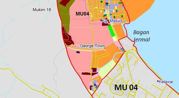
7 Land reclamation in the Penang Structure Plan up to 2020 Map of Penang and reclamation sites 3-4 islands in TanjongTokongto Gurney Drive Island in middle bank between Penang Island and Sebarang Perai South east of island around BatuMaungand Gertak Sanggul North of Butterworth container port Mud flats in SebarangPeraisouth of Penang bridge 7
8 Past land reclamation in Penang Land reclamation in Koayjetty of clan jetties for residential flats in 1970s BayanBaruindustrial estate in 1980s and PDC developments in 1990s Jelutongland reclamation for coastal highway in 1990s TanjungTokongin 2000s for residential and commercial development 8
9 TanjungTokongLand Reclamation Largest land reclamation to date for residential and commercial purposes with 3 islands making a total of 980 acres given to private developer Serious siltation in Gurney Drive after phase 1 of land reclamation of 240 acres Only preliminary EIA submitted and approved internally by DOE in the 1980s and no monitoring of adverse impacts when land reclamation took place Approval in principle given for further 2 islands reclamation of 740 acres despite adverse impacts of phase 1 9


10 10

11 Land use plan 11
12 Future development in Tanjung Tokong Development under structure plan ( ) Tebusguna Pembangunan Tangung Seri Pinang - Kerja tebusguna untuk pembangunan Waterside - marina, promenade, jeti, komersial, restoran, kediaman, kemudahan utk kapal layar & sukan laut, membeli belah & industri makanan Proposed Tanjung Seri Pinang Reclamation marina, promenade, pier, commercial outlets, restaurants, residential suites, yachting & sea sports activities, shopping and dining. 12 Artist illustration- Development in islands of Tg Seri Pinang
13 Land reclamation in the Straits of Penang Proposed island in the middle bank in Structure Plan but this is important nursery and feeding area of commercial fish species Jelutong highway and IJM development BayanBarureclamation for industrial development Queensbay land reclamation Batu Maung land reclamation Proposed land reclamation in Perai 13
14 Some other future projects Penang port proposed land reclamation of 400 hectares (about 1,000 acres) for new mini free industrial zone and halallogistic hub in Butterworth Port deepening (RM350 million) North of Penang bridge 61.5 hectares South of Penang bridge 14 ha +25 hectares of Bayan Mutiara 14


15 Future development Bayan Mutiara by PDC ekar Tebusguna kompleks kerajaan, kediaman mewah, hotel, dll. (government complexes, residential properties like waterfront villa, bangalows, service apartments and hotels) Land use 15
16 Future development Pembangunan Bayan Mutiara projek PDC ekar Tebusguna kompleks kerajaan, kediaman mewah, hotel, dll. Gold Coast Resort (government complexes, residential properties like waterfront villa, bangalows, service apartments and hotels) 16
17 Future development at second bridge site Aktiviti tebusguna tanah di kawasan Bt Maung Second Penang Bridge 17
18 Future development i. Jambatan Pulau Pinang Kedua ii. Southbay dan Sunway Mutiara iii. Pembesaran Pelabuhan Tuna Antarabangsa i. Second Penang Bridge ii. Urban developments such as Southbay and Sunway Mutiara iii. International Tuna Port expansion Proposed International Tuna Port, Batu Maung 18
19 Environmental impacts of land reclamation Land reclamation methods mainly from sea sand pumped from sea bottom Sand preferred as fill material as mud too soft for construction and mud pushed out into sea causing pollution and sedimentation all along coast Beach erosion takes place as dynamic equilibrium disrupted. Reclaimed area often blocks flow of currents and sediment transport Earth and soil not much used because of being not available and higher cost though used in some other countries. Sand also brought from other areas and neighboring states and countries 19
20 Pumping sea sand to reclamation area 20
21 Major environmental impacts During land reclamation Loss of natural ecosystem, e.g. Mangroves, fishing grounds Increased sedimentation and water pollution as marine mud and clay pushed out to sea After land reclamation Change of current patterns and water movement Sedimentation and erosion at different parts of coast Impacts of consequent development Traffic impacts Visual and esthetic impacts 21
22 Department of Environment guidelines 1. A Handbook of EIA Guidelines 2. EIA Guidelines for Coastal and Land reclamation Activities 3. Guidelines for erosion control of development projects in coastal zones 1/97 4. Guidelines for preparation of coastal engineering hydraulic studies and impact evaluation EIA Guidelines for Coastal and Land Reclamation 22
23 EIA guidelines for Coastal and Land Reclamation Projects Potential significant projects Physical system Biological system Socio-economic system Economic assessment, including cost benefit analysis Mitigation and Abatement measures Environment Management Plan Includes monitoring of impacts and effectiveness of mitigation measures 23
24 Why no implementation of DOE guidelines in major land reclamation? Preliminary versus detailed EIA No detailed EIA even for large projects like Tanjung Tokong Preliminary EIA reviewed and approval in-house in DOE often without expertise or external expert input Little or no public participation of affected stakeholders No monitoring of environmental impacts and effectiveness of proposed mitigation methods No accountability on part of developer to reverse adverse impacts No accountability of EIA consultants 24
25 Need to review all land reclamation projects Tanjung Tokong land reclamation Preliminary EIA done 20 years ago EIA predicted no adverse environmental impacts EIA proven wrong. Who is supposed to monitor impacts? Need a review and inquiry of what went wrong and how such a major mistake can take place Who is responsible for siltation problems and who should pay for damage? DOE? EIA consultants? Developers? Government who approved the project Should the new state government agree in principle to the further reclamation of 2 more large islands? Should a new detailed EIA be required before approval of any more land reclamation? 25
26 Who has the right to reclaim land? Only State government has sole legal right to reclaim land but sometimes this right given away Economic benefits for public. Land in principle should not be given out to private developers as land sale as a source of income of the state. This is common practice in other countries such as Singapore and Hong Kong for government agencies to do land reclamation and then auction to get best economic deal Meeting social needs first before private profit. State also cannot determine land use for social needs after rights to reclaim given away to private sector. Land reclamation should be for public and social purposes which should be a higher priority than private development Ensure that illegal land reclamation, such as Tanjung Bungah sore thumb is stopped as this is a challenge to state authority 26
27 What should land reclaimed be used for? Public open space requirements in Structure Plan Based on 1 st Penang Structure Plan of 4 ha of public open space per 2500 persons, need in the region of 936 hectares on Penang Islandand 1000 ha in SebarangPerai. Present provision is 274 ha on Island and 175 in SebarangPerai. There is a shortfall of shortfall is 660 ha on Island and 825 in Sebarang Perai. Total shortfall is 1486 ha. How can Penang provide public open space? Strategy to provide recreational space that is lacking in urban areas is through land reclamation Public amenities Picnic areas, recreational space, bicycle lanes, jogging tracks, sports activities and community centers may have to come from reclaimed land 27
28 Development control of reclaimed land Development control Land use for public open space and not development right up to water s edge Height control to prevent obstruction of sea view Setback from high water mark Public access and use of coast line and beaches Residential development and not exclusive gated communities Commercial development including restaurants and food courts for the public and tourism Industrial development if appropriate 28
29 Legal issues of reclaimed land Reclaimed land and the Malaysian National Land Code Free hold versus lease-hold land as stipulated under National Land Code, Penang policy of giving developers freehold status is illegal Whocontrols development in reclaimed land? Why MPPP and MPSP has no control over development of reclaimed land? Legal loophole? All beaches are public from high water mark to 60 meters but developers claim all land to water front. Why is this legal requirement ignored? Height control guidelines in reclaimed land not applied and high rise block view and access to water front 29
30 What is needed in Penang on land reclamation? Policy and a master plan for coastal land reclamation Identification of social needs for reclamation Identification of possible conflicts of land reclamation as adverse impacts on other parts of coastline Development policy and control must consider all stakeholders interest Development control guidelines, including height control Detailed EIA and not preliminary for all major land reclamation with full public participation and hearings Review of existing and future land reclamation proposals by impartial task force with the necessary expertise. What lessons for the future? 30
31 Institutional mechanism for planning and implementation of land reclamation Current fragmentation of authority responsibility for implementation split to different department and agencies Land office, District office, PDC, MPPP, MPSP Planning Department, DOE, JKR, DID, Marine Department Land reclamation authority Coordinating agency needed. PDC to be given back authority or establish new authority 31
Coast Protection, Development and Coastal Biodiversity. Brian Caton Member CEMAC, AMLR NRM Former Chair & Member, Coast Protection Board
 Coast Protection, Development and Coastal Biodiversity Brian Caton Member CEMAC, AMLR NRM Former Chair & Member, Coast Protection Board Saltmarsh: an extensive problem for Biodiversity and Planning Law
Elevated homes. Exceptional view. Excellent value. Extra long car porch. Wide built-up. Big garden. Not too big. Not too small. Just right.
 Live distinctively Distinguished homes to call your own Every individual is different, with distinct needs, tastes and ways of life. We believe that your home should reflect you and your family s lifestyle
A Current View of Penang s Development: Rhetoric & Reality
 A Current View of Penang s Development: Rhetoric & Reality Dr. Lim Mah Hui MPPP Councillor Penang Forum 5, Penang August 4, 2012 1 State Government Penang Blueprint p.135 liveable city defined broadly
SH1 - Causeway, Auckland, 2014 (Source: NZ Transport Agency)
") SH1 - Causeway, Auckland, 2014 (Source: NZ Transport Agency) Coastal effects assessment guide Environmental and social responsibility policy State highway environmental plan Transport Agency statement
SH1 - Causeway, Auckland, 2014 (Source: NZ Transport Agency) Coastal effects assessment guide Environmental and social responsibility policy State highway environmental plan Transport Agency statement
Penang Eco T own Workshop Sharing Information And Experiences In Dev eloping A Recycling Oriented Society MAJLIS PERBANDARAN SEBERANG PERAI
 1 2 CONTENTS 1. History Of Eco Town Concept 2. Programmes Towards Eco Town Seberang Perai 3. Broader Horizon On Eco Town 4. Conclusion 3 1. HISTORY OF ECO-TOWN PROJECT Need Assessment Survey was sent by
The Jigsaw: Legal Instruments for Biodiversity Planning in South Africa
 The Jigsaw: Legal Instruments for Biodiversity Planning in South Africa Annual Conference, Environmental Law Association AUGUST 2012 Dr. Marie Parramon-Gurney Head of Programmes: Sustainability and Development
Final Master Plan and Development Control Regulations
 1. INTRODUCTION CHECK LIST a. Introduction b. Table of contents c. Definitions. d. scope of works. 2. FINAL OVERALL MASTER PLAN a. SITE ANALYSIS and OVERVIEW: i. Existing and Proposed Site Plan Levels.
Policy for management and protection of the coast
 Policy for management and protection of the coast Policy for management and protection of the coast Mona Ohlsson Samhällsbyggnadsförvaltningen Ystads kommun, 2008 3 THE MUNICIPALITY GUIDELINES REGARDING
Parks Master Plan Implementation: Phase I Waterfront Use and Design REPORT #: September 7, 2016 File #
 0 'O DI Lan-171-14 1 - THE CORPORATION OF THE TOWN OF COBOURG..,. STAFF REPORT TO: FROM: Mayor and Members of Council Dean A. Hustwick, Director of Recreation and Culture DATE OF MEETING: Committee of
KHARTOUM GARDEN CITY. Dietmar Kamphans
 KHARTOUM GARDEN CITY Dietmar Kamphans As most cities in the world have been set up at river banks and sea shores, even Khartoum is located at the confluence of the Blue and White Nile. Beside the regular
EIA process in Malaysia. Approaches and Strategies. Way Forward
 PUBLIC PARTICIPATION APPROACHES AND STRATEGIES UNDER THE EIA PROCESS IN MALAYSIA By Norhayati Mohamad Yusof Principal Assistant Director Department of Environment Malaysia AECEN REGIONAL WORKSHOP Strengthening
3 Summary of Major Views and Responses
 3 Summary of Major Views and Responses 3.1 Major Views 3.1.1 The comments and suggestions received from various channels and parties during the two-month Stage 1 PE on the Study, which have been discussed
Workshop on Area-based Management and Regional Cooperation for the Implementation of Ocean-related Sustainable Development Goals
 Workshop on Area-based Management and Regional Cooperation for the Implementation of Ocean-related Sustainable Development Goals UN Environment and European Commission 9-10 February 2017, Brussels Healthy
EXHIBIT A CITY OF FORT WALTON BEACH, FLORIDA COASTAL MANAGEMENT & CONSERVATION
 EXHIBIT A CITY OF FORT WALTON BEACH, FLORIDA INTRODUCTION The Coastal Management and the Conservation Elements required by Chapter 9J-5.012 and 5.013, F.A.C., respectively, have been combined into one
CASE STUDY-DEVELOPMENT IN AN ENVIRONMENTALLY SENSITIVE AREA
 Audit Office of the Republic of Cyprus CASE STUDY-DEVELOPMENT IN AN ENVIRONMENTALLY SENSITIVE AREA Sotiris Christofi Audit Officer EUROSAI WGEA Spring Session on Environmental Governance Helsinki, 26-27
City of Rockingham. Local Management Practices, Costs and Strategic Coastal Planning
 City of Rockingham Local Management Practices, Costs and Strategic Coastal Planning Decision Making Process Considerations Climate Change Response Action Plan Ongoing observations/major Storm events Ongoing
SHORELINE, FLOOD AND COASTAL DEFENCE MANAGEMENT PLANS
 These plans may provide opportunities as well as concern for recreational boating. They are currently being revised and consulted on. This document explains how we can engage in the process. Shoreline,
Options for Managing Coastal Erosion. Presentation by: Ashley Sprague
 Options for Managing Coastal Erosion Presentation by: Ashley Sprague Shoreline stabilization methods Armouring - Boulders/rockwalls most common method of erosion control in Nova Scotia Concerns: - Accelerate
A CONCEPTUAL PROPOSAL BY THE UMDLOTI FORUM Representing the Umdloti Ratepayers and Residents Association and the emdloti UIP
 A CONCEPTUAL PROPOSAL BY THE UMDLOTI FORUM Representing the Umdloti Ratepayers and Residents Association and the emdloti UIP PRESENTATION STRUCTURE 1.0 Overview of Umdloti 2.0 Current challenges in Umdloti
6 PORT SYDNEY SETTLEMENT AREA
 Section 6 Port Sydney Page 61 6 PORT SYDNEY SETTLEMENT AREA 6.1 Basis and Principles Village of Port Sydney Waterfront Community Existing Services 6.1.1 Port Sydney is an historic settlement that has developed
In 1983, the town evacuated and purchased by government for $36 million
 1 2 3 4 5 6 7 8 9 Introduction to Environmental Geology, 5e Chapter 17 Soil and Environment Weathering: summary in haiku form Rocks brought to surface decompose to sediment and that's weathering. Case
Scarborough Waterfront Project
 Scarborough Waterfront Project Public Information Centre #1 Environmental Assessment Terms of Reference September 10, 2014 Agenda Open House Presentation 7:00 to 7:30 pm Presentation 7:30 to 8:15 pm History
STEWARDSHIP OF LONG ISLAND SOUND S ECOLOGICAL AND RECREATIONAL RESOURCES
 STEWARDSHIP OF LONG ISLAND SOUND S ECOLOGICAL AND RECREATIONAL RESOURCES Robin Kriesberg, Save the Sound, Inc. Thomas Halavik, US Fish and Wildlife Service Coastal Program An Initiative to Identify, Protect
Nothing lasts forever planning for successful mine closure
 Nothing lasts forever planning for successful mine closure Tommi Kauppila, Geological Survey of Finland All mines eventually close All mines have a finite life-of-mine (LOM): Eight years for a typical
Ashbridges Bay Erosion and Sediment Control Project
 Ashbridges Bay Erosion and Sediment Control Project Project Brief Overview Toronto and Region Conservation Authority, in partnership with the City of Toronto, intends to carry out remedial erosion control
Chelsea Creek Municipal Harbor Plan
 Chelsea Creek Municipal Harbor Plan Public Meeting #1 June 11th, 2018 1 Presentation outline I. Introduction: Why are we doing this plan? II. Evolution of Chelsea Creek III. State of Chelsea Creek IV.
Planning of offshore wind farms in Lithuania. Migl Masaityt Chief Specialist of EIA division Ministry of Environment of Lithuania
 Planning of offshore wind farms in Lithuania Migl Masaityt Chief Specialist of EIA division Ministry of Environment of Lithuania Legal framework (1) General issues Law on Land of the Republic of Lithuania,
Broward County Coastal Engineering Consultant Services For Segment III Shore Protection T P1 R. Harvey Sasso, P.E. Danielle Irwin, CFM
 Coastal Systems International, Inc. Broward County Coastal Engineering Consultant Services For Segment III Shore Protection T2112588P1 R. Harvey Sasso, P.E. Danielle Irwin, CFM Experts in Coastal Engineering,
TERMS OF REFERENCE MALASPINA COMPLEX COASTAL PLAN
 TERMS OF REFERENCE MALASPINA COMPLEX COASTAL PLAN A. RATIONALE Land and Water BC, resource user groups and the Powell River Regional District have requested that the Ministry of Sustainable Resource Management
Purpose of Tonight s Meeting
 Location Map 3 Purpose of Tonight s Meeting Explain to you the Alternatives considered Provide information about these Alternatives Engineering Environmental Present the Project Schedule Obtain your input
Planning Commission Report
 Planning Commission Report To: From: Subject: Planning Commission Meeting: January 6, 2016 Agenda Item: 8-B Planning Commission David Martin, Planning & Community Development Director Introduction to the
Errol Heights Park and Community Garden Frequently Asked Questions March 22, 2018
 Errol Heights Park and Community Garden Frequently Asked Questions March 22, 2018 Question 1: What improvements are planned for Errol Heights Park? How will the community be engaged in the process to shape
P.T. AGUNG PODOMORO Villa Serpong Resort
 P.T. AGUNG PODOMORO Villa Serpong Resort 1 DRAFT #4 (AND FINAL) Newton's Pty Ltd VIDEO DOCUMENTARY SCRIPT VISION 1 Reflection on the river of a boatman, poling his bamboo raft. A herd of cattle swim in
Vision for East Cowes
 Vision for East Cowes A better East Cowes for now and the future The East Cowes Regeneration project is a major regeneration scheme on the Isle of Wight. It will create a vibrant community with a long-term
21st September 2010 Bandung Eco-Creative Fest Fair Bandung City Hall
 21st September 2010 Bandung Eco-Creative Fest Fair Bandung City Hall The Penang Eco-Town Penang Eco-Town Area Initial Studies for Penang Eco-Town Policy Needs Legal Framework Importance of Policy Strategic
Coastal Climate Change Vulnerability and Flexible Adaptation Planning: the Cockburn Sound Coastal Alliance Experience
 Coastal Climate Change Vulnerability and Flexible Adaptation Planning: the Cockburn Sound Coastal Alliance Experience Presentation to Climate Change Forum by Doug Vickery Manager Infrastructure Services,
PHASE ONE. A summary report: What the community told Alcoa during Phase One of the community engagement program for Point Henry 575.
 PHASE ONE A summary report: What the community told Alcoa during Phase One of the community engagement program for Point Henry 575. DECEMBER 2015 FEBRUARY 2016 INTRODUCTION In 2014 Alcoa closed its Point
Shoreline Master Program Town of La Conner, Washington
 Shoreline Master Program Town of La Conner, Washington Department of Ecology approval effective Adopted September 24, 2013 by Town of La Conner Ordinance No.1106 Amended May 13, 2014 by Town of La Conner
Gibsons Foreshore & Seawalk Improvements
 Gibsons Foreshore & Seawalk Improvements Open House (5:00-7:00 pm) Town of Gibsons October 6, 2016 Town of Gibsons Foreshore & Seawalk Improvements 1 Session 3: Open House (Charrette Participants, Designers,
Palm Jebel Ali - Dubai, United Arab Emirates
 Palm Jebel Ali - Dubai, United Arab Emirates LOCATION: CLIENT: Dubai Tony Perrin Senior Development Manager Dubai Waterfront Co LLC PROJECT SIZE: 1000 acres SCOPE OF WORK: Urban Design and Landscape Architecture
Task Force on Harbourfront Developments on Hong Kong Island
 Task Force on Harbourfront Developments on Hong Kong Island For discussion TFHK/10/2016 On 25 May 2016 PURPOSE This paper seeks Members views on the reprovisioning of Tin Chiu Street Playground (TCSP)
Environmental Impact Assessment (EIA) Training Session
 Training Session") Die Deutsche Gesellschaft für Internationale Zusammenarbeit (GIZ) GmbH Environmental Impact Assessment (EIA) Training Session By: Nedal Al Ouran (Ph.D.) AMMAN- November 6, 2013 Outline 1. Introduction
Die Deutsche Gesellschaft für Internationale Zusammenarbeit (GIZ) GmbH Environmental Impact Assessment (EIA) Training Session By: Nedal Al Ouran (Ph.D.) AMMAN- November 6, 2013 Outline 1. Introduction
Growing. Our masterplanning and urban design team is focused on addressing the complex issues affecting our towns, cities and neighbourhoods.
 Growing 1 We re passionate about creating healthy, vibrant urban environments where people want to live and visit, where they feel an active part of their communities and the public realm. (singular. a
TO: Port of Orcas FROM: Tina Whitman, Science Director SUBJECT: Master Plan Update DATE: September 7, 2018
 TO: Port of Orcas FROM: Tina Whitman, Science Director SUBJECT: Master Plan Update DATE: September 7, 2018 Friends of the San Juans appreciates the opportunity to provide input to the Port of Orcas Master
PUBLIC. Ai + Architecture LLC., 90 Belknap Street, Concord, MA 01742, USA (t) (f)
 (f)") PUBLIC Ai + Architecture LLC., 90 Belknap Street, Concord, MA 01742, USA www.ai-architecture.com +1 978 369 2730 (t) +1 978 369 2731 (f) 2004 Olympic Sailing Center & Marina Village Agios Kosmas, Athens,
PUBLIC Ai + Architecture LLC., 90 Belknap Street, Concord, MA 01742, USA www.ai-architecture.com +1 978 369 2730 (t) +1 978 369 2731 (f) 2004 Olympic Sailing Center & Marina Village Agios Kosmas, Athens,
Methodology on Functional Linkage between Marine and Terrestrial Areas
 Methodology on Functional Linkage between Marine and Terrestrial Areas prepared within the frame of the project on Coastal and Maritime Spatial Planning in Pärnu Bay Area and Coastal Municipalities of
A Joined-up Regional Landscape: A Roadmap to connect the parts
 Breaking the Barriers: Engineering Solutions to Ecological Problems A Joined-up Regional Landscape: A Roadmap to connect the parts Associate Professor Darryl Low Choy Urban Research Program Outline Nature
Port Lavaca Future Land Use
 Port Lavaca Future Land Use Introduction The City of Port Lavaca is beginning to see sustained growth, after many years of relative stable population. New single family homes, apartments, and businesses
North Fair Oaks Community Plan Summary and Information
 North Fair Oaks Community Plan Summary and Information WHAT IS THE NORTH FAIR OAKS COMMUNITY PLAN? The North Fair Oaks Community Plan is part of the San Mateo County General Plan, and establishes policies
Master Environmental Servicing Plan & Secondary Plan
 1 East Side Lands Stage 2 Master Environmental Servicing Plan & Secondary Plan Public Consultation Centre #4 March 20, 2018 Welcome! Today s Agenda Please sign in at the registration table. 6:00 pm 6:30
Step by step, the construction of a coherent overall restoration on the Seine estuary the role of GIP Seine-Aval
 Step by step, the construction of a coherent overall restoration on the Seine estuary the role of GIP Seine-Aval Stéphanie Moussard GIP Seine-Aval Seine estuary - France I-Introduction to the Seine estuary
14 HIGHWAY PLANTING AND IRRIGATION
 14 HIGHWAY PLANTING AND IRRIGATION 14.1 General The Design-Builder shall conduct all Work necessary to meet the requirements for highway planting and irrigation, including erosion control, weed control,
Wentworth Point July Community Information Session Feedback Summary
 Wentworth Point July Community Information Session Feedback Summary Introduction On Saturday, 28 July 2018, Landcom held a community information session from 11am to 1pm, at the Pulse Club, Wentworth Point,
VIRGINIA KEY CONSENSUS MASTER PLAN
 VIRGINIA KEY CONSENSUS MASTER PLAN JULY 2010 Existing Conditions JULY 2010 STAKEHOLDER INTERVIEW PROCESS, January 18-22, 2007 PUBLIC MEETING #1: SITE INVENTORY AND ANALYSIS, March 29, 2007 PUBLIC MEETING
ASSESSMENT OF THE URBAN AND TOURISM DEVELOPMENT IN THE FENER-BALAT DISTRICTS. Sevgul Limoncu & Banu Celebioglu
 ASSESSMENT OF THE URBAN AND TOURISM DEVELOPMENT IN THE FENER-BALAT DISTRICTS Sevgul Limoncu & Banu Celebioglu Fener and Balat districts are located in the Historical Peninsula, in the region stretching
Stock-Taking on Integrated Coastal Zone Management (ICZM) in the Black Sea IMPLEMENTATION AUDIT QUESTIONNAIRE 2010
 in the Black Sea IMPLEMENTATION AUDIT QUESTIONNAIRE 2010") Stock-Taking on Integrated Coastal Zone Management (ICZM) in the Black Sea IMPLEMENTATION AUDIT QUESTIONNAIRE 2010 PURPOSE The purposes of this questionnaire are: (a) to perform the policy, legal and institutional
Stock-Taking on Integrated Coastal Zone Management (ICZM) in the Black Sea IMPLEMENTATION AUDIT QUESTIONNAIRE 2010 PURPOSE The purposes of this questionnaire are: (a) to perform the policy, legal and institutional
New York City, 19 th c.
 New York City, 19 th c. Lower Manhattan, circa 1930s Westside Highway, Manhattan, circa 1940s Greenpoint Terminal Market, Brooklyn TRANSFORMATIONS ON THE WATERFRONT Harlem River Park, Manhattan BEFORE
ENVIRONMENTAL ISSUES and TEN-T PROJECTS Key elements for a sustainable network development
 ENVIRONMENTAL ISSUES and TEN-T PROJECTS Key elements for a sustainable network development TEN-T Project Management Workshop 2010 George Kremlis DG ENV B4, European Commission 13 January 2010 Environmental
HAZARD MITIGATION GOALS AND OBJECTIVES
 SEWRPC Community Assistance Planning Report No. 282, 2nd Edition CITY OF MILWAUKEE ALL HAZARDS MITIGATION PLAN UPDATE Chapter IV HAZARD MITIGATION GOALS AND OBJECTIVES [NOTE: Throughout this plan update
Contents of Part 6. Part 6 Zones
 Contents of Part 6 Part 6 Zones... 6-1 6.1 Preliminary... 6-1 6.2 Zone codes... 6-3 6.2.1 Low density residential zone code... 6-3 6.2.1.1 Application... 6-3 6.2.1.2 Purpose and overall outcomes... 6-3
{Best Practices. Summary of Tools, Strategies and Best Practices from 11 Michigan Case Study Communities
 Case Studies Michigan Coastal Community Working Waterfronts { Summary of Tools, Strategies and from 11 Michigan Case Study Communities Table of Contents Zoning...2 Community and Stakeholder Collaboration
A global view of integrated closure and legacy planning
 18 September 2013 A global view of integrated closure and legacy planning Mine Closure 2013, Eden Project, Cornwall Dr. William Adams General manager, Legacy and Closure A changing business climate The
ACCESS QATAR S MULTI-BILLION DOLLAR INTERIORS MARKET +5,000 ATTENDEES +250 EXHIBITORS SQM. index-qatar.com
 ACCESS QATAR S MULTI-BILLION DOLLAR INTERIORS MARKET +5,000 ATTENDEES +5,000 SQM +250 EXHIBITORS index-qatar.com A very high calibre of visitor and great footfall made INDEX Qatar a great platform for
PETERHEAD PORT AUTHORITY ENVIRONMENTAL STATEMENT. Non-Technical Document
 PETERHEAD PORT AUTHORITY ENVIRONMENTAL STATEMENT Document No 5357/04 Rev FINAL Issued January 2015 West Pier Peterhead Aberdeen AB42 1DW Niras Fraenkel Ltd Merlin House Mossland Road Hillington Park Glasgow
HEARING PUBLIC GOALS. Conduct a public hearing on the proposed Public Works Plan Amendment #7 (PWPA7);
;") HEARING PUBLIC GOALS Conduct a public hearing on the proposed Public Works Plan Amendment #7 (PWPA7); Find that adoption of PWPA7 is consistent with Coastal Act; Approve and authorize the Chair of the
HEARING PUBLIC GOALS Conduct a public hearing on the proposed Public Works Plan Amendment #7 (PWPA7); Find that adoption of PWPA7 is consistent with Coastal Act; Approve and authorize the Chair of the
i n S o u t h e r n M a i n e
 Coastal Access i n S o u t h e r n M a i n e an open discussion among regional stakeholders Friday, June 2, 2006 9 am 4 pm University of New England Campus Center Multipurpose Room Biddeford, ME SITUATION
George Hotel application STAFF REVIEW COMMITTEE OF THE WHOLE JANUARY 14, 2014
 George Hotel application STAFF REVIEW COMMITTEE OF THE WHOLE JANUARY 14, 2014 1 Presentation outline Purpose: to seek Council direction for next steps in the review process Application process to date
Developing the Joint Action Plan
 Developing the Joint Action Plan MAJOR COSTAL PROJECTS 1. TITLE OF THE PROJECT: Larnaca North Coastal Redevelopment Project 2. BRIEF DESCRIPTION OF THE TYPOLOGY OF THE PROJECT (max ½ or 1 page) - Hard
Environmental Impact Assessment
 Environmental Impact Assessment Environmental impact assessment (EIA) is the process of systematically drawing together an assessment of the likely significant environmental effects of a development project.
We provide exceptional solutions to help our clients achieve success.
 We provide exceptional solutions to help our clients achieve success. We began as a small, two-person surveying firm called M.E. Berry & Associates in Hollywood, Florida. Known today as Calvin, Giordano
SUMMARY. Support the Southeast Arkansas Regional Intermodal Facility.
 SUMMARY THE I-69 LOCATION STUDY The proposed I-69 Location Study from El Dorado to McGehee, Arkansas, represents one section (Section of Independent Utility No. 13) of the nationally designated I-69 Corridor
PARTF Scoring System for Grants
 PARTF Scoring System for Grants The members of the N.C. Parks and Recreation Authority use the PARTF scoring system as one of several tools to select grant recipients. Please provide all of the information
HBF Marine Study: Victoria Harbour: Water dependent and water related uses and associated land/water interface implications
 HBF Marine Study: Victoria Harbour: Water dependent and water related uses and associated land/water interface implications Presentation on the Initial Findings 9 February 2011 Harbour Business Forum Background
Mark-up of the effect of the proposed Bronte Village Growth Area OPA No.18 on the text of section 24, Bronte Village, of the Livable Oakville Plan
 Mark-up of the effect of the proposed Bronte Village Growth Area OPA No.18 on the text of section 24, Bronte Village, of the Livable Oakville Plan Notes: This document is provided for information purposes
The role of Universities: Civic Design and planning futures
 What did planning ever do for us? A celebration of Civic Design and Planning The role of Universities: Civic Design and planning futures 24 th May 2013 Sue Kidd Head of Civic Design Dept of Geography and
PURPOSE: The purpose is to provide commercial facilities in the Vancouver and Clark County vicinity.
 US Army Corps of Engineers Seattle District Joint Public Notice Application for a Department of the Army Permit and a Washington Department of Ecology Water Quality Certification and/or Coastal Zone Management
BATHURST QUAY NEIGHBOURHOOD PLAN IMPLEMENTATION. Streetscape & Public Realm Improvement Plan - Canada Malting Silo Site and Eireann Quay
 BATHURST QUAY NEIGHBOURHOOD PLAN IMPLEMENTATION Streetscape & Public Realm Improvement Plan - Canada Malting Silo Site and Eireann Quay Bryan Bowen, Waterfront Secretariat November 25, 2017 Presentation
MEETING HELD AT THE EDTEA OFFICES (ethekwini) ON 03 July 2018 AT 10h00. Ms. Naadira Nadasen (NN) Mrs Chen read (CR) and Mrs Tejal Singh (TS)
 ON 03 July 2018 AT 10h00. Ms. Naadira Nadasen (NN) Mrs Chen read (CR) and Mrs Tejal Singh (TS)") MINUTES OF THE PRE-APPLICATION MEETING IN RESPECT OF THE APPLICATION FOR ENVIRONMENTAL AUTHORISATION OF THE PROPOSED BEACHWOOD RESORT AND ESTATE DEVELOPEMENT MEETING HELD AT THE EDTEA OFFICES (ethekwini)
MINUTES OF THE PRE-APPLICATION MEETING IN RESPECT OF THE APPLICATION FOR ENVIRONMENTAL AUTHORISATION OF THE PROPOSED BEACHWOOD RESORT AND ESTATE DEVELOPEMENT MEETING HELD AT THE EDTEA OFFICES (ethekwini)
DRAFT SECTION 4(F) EVALUATION KOLLINER PARK
 EVALUATION KOLLINER PARK") DRAFT SECTION 4(F) EVALUATION I. DESCRIPTION OF SECTION 4(F) RESOURCE The Section 4(f) resource potentially affected by the proposed action is Kolliner Park. The Alternative B-1 and C bridge crossings
DRAFT SECTION 4(F) EVALUATION I. DESCRIPTION OF SECTION 4(F) RESOURCE The Section 4(f) resource potentially affected by the proposed action is Kolliner Park. The Alternative B-1 and C bridge crossings
Using a Citizen s Wetland Education Workshop As A Tool in Regulatory Compliance
 Using a Citizen s Wetland Education Workshop As A Tool in Regulatory Compliance (A Driver s Safety Course for Wetland Violators) Kevin R. Du Bois, P.W.S. ASWM Wetlands 2007 National Symposium August 28-30,
PLANNING ADVISORY BOARD AGENDA OCTOBER
 ! City of Langley PLANNING ADVISORY BOARD AGENDA OCTOBER 1, 2014 3-5pm LANGLEY CITY HALL - 112 2 nd Street, Langley WA 1) Call to Order and Roll Call 2) Approval of the Minutes September 10, 2014 3) Public
FAQ S about Restoration Planning FROM THE Department of Ecology WEBSITE:
 FAQ S about Restoration Planning FROM THE Department of Ecology WEBSITE: http://www.ecy.wa.gov/programs/sea/sma/st_guide/smp/restoration/qanda.html Notations in parentheses are staff notes directing you
Zoning and Development Considerations in the Boothbay Harbor Maritime/Water Dependent District
 Zoning and Development Considerations in the Boothbay Harbor Maritime/Water Dependent District Bob Faunce Lincoln County Planner Lincoln County Regional Planning Commission Board of Selectmen and Planning
City Center Neighborhood Plan
 [1] City Center Neighborhood Plan As adopted by Ordinance No. 2014-09-049 and amended by Ordinance Nos. Formerly CBD Neighborhood as adopted by Ordinance No. 8868 and amended by Ordinance Nos. 8946, 9693,
Santa Cruz in Tenerife signs agreement with Cepsa to study the city's transformation on the site of Cepsa's Refinery
 Santa Cruz in Tenerife signs agreement with Cepsa to study the city's transformation on the site of Cepsa's Refinery The Green Santa Cruz 2030 Project will create a large area of green spaces and public
THE BIG MULTIPLIER
 THE BIG MULTIPLIER GURGAON S NEW LANDMARK The Grand Arch from Ireo is designed to be Gurgaon s new landmark residential complex. Spread over almost 20 acres, The Grand Arch s unique architecture and use
Common Oceans Program
 Capacity Building Common Oceans Program Program objective: To promote efficient and sustainable management of fisheries resources and biodiversity conservation in the ABNJ, in accordance with the global
MARINA MARKET & WATERFRONT DEVELOPMENT STUDY PORT ARANSAS, TEXAS
 MARINA MARKET & WATERFRONT DEVELOPMENT STUDY PORT ARANSAS, TEXAS FEBRUARY 2015 PRESENTATION OUTLINE 1 2 3 4 5 6 7 REGIONAL POSITIONING SITE IMPRESSIONS PLANNING & DESIGN PRINCIPLES EXISTING IMPROVEMENTS
Overview of Paldiski Windpark land-use planning and environmental impact assessment process
 Overview of Paldiski Windpark land-use planning and environmental impact assessment process OÜ Hendrikson&Ko Raekoja plats 8 Tartu 51004 Estonia www.hendrikson.ee Kuido Kartau Licenced environmental expert
OBSERVING AND EXPERIENCING TRADITIONAL NEIGHBOURHOOD AND PLANNED HOUSING
 OBSERVING AND EXPERIENCING TRADITIONAL NEIGHBOURHOOD AND PLANNED HOUSING Housing Dwelling Shelter Home Settlement Residential Neighbourhood Real Estate Property Traditional Neighbourhood? Unplanned settlement,
State-of-the-art. Modern. Advanced.
 Civil Construction State-of-the-art. Modern. Advanced. We own and operate our own equipment, which sets us apart from many of our competitors. Having been a key player in the Queensland and Australian
37 Interlaken A Vision To The Future
 37 Interlaken A Vision To The Future The History The Beckwith or Bonnie Briar Estate is one of the original Berkshires Cottages. It was built in 1892 and designed by architect and wealthy owner Leonard
Hunt Highway CELESTE PEMBERTON, CFM, CPM PINAL COUNTY CARLOS SANCHEZ SORIA, PE T.Y. LIN INTERNATIONAL
 Hunt Highway CELESTE PEMBERTON, CFM, CPM PINAL COUNTY CARLOS SANCHEZ SORIA, PE T.Y. LIN INTERNATIONAL Agenda Design Concept Report Phase 1 Phase 2 Phase 3 Phase 4 Phase 5 Questions Design Concept Report
Support the implementation of Cape Coral's Comprehensive Plan. Protect and utilize the unique natural resources in the City.
 7.0 OVERVIEW - RECOMMENDATIONS Chapter 7 The preparation of the Cape Coral Parks and Recreation Master Plan spanned a period of approximately 12 months. Plan preparation included the input of a wide range
FEEDBACK FORM GEORGE TOWN WORLD HERITAGE SITE SPECIAL AREA PLAN (REVIEW)
") FEEDBACK FORM GEORGE TOWN WORLD HERITAGE SITE SPECIAL AREA PLAN (REVIEW) The George Town World Heritage Site Special Area Plan is in the process of being reviewed and enhanced. We therefore seek your cooperation
FEEDBACK FORM GEORGE TOWN WORLD HERITAGE SITE SPECIAL AREA PLAN (REVIEW) The George Town World Heritage Site Special Area Plan is in the process of being reviewed and enhanced. We therefore seek your cooperation
Executive Office of Energy and Environmental Affairs Massachusetts Vulnerability Preparedness Program. June 6, 2018
 Executive Office of Energy and Environmental Affairs Massachusetts Vulnerability Preparedness Program June 6, 2018 Presentation Outline: 1. What Natural Hazards Impact Falmouth 2. Coastal Resiliency Efforts
1. POPLAR LANDING + MUNI EVERS PARK
 . POPLAR LANDING + MUNI EVERS PARK WHAT S HAPPENING? PROJECT DESCRIPTION PROJECT TIMELINE Poplar Landing and the future Muni Evers Park site (located at 00 Quayside Drive) is jointly owned by the City
CHONGMING ISLAND SHANGHAI CENTRAL CITY
 Chongming Island CHONGMING ISLAND SHANGHAI CENTRAL CITY Chongming Island Shanghai, China THE VISION: A GREEN ISLAND Chongming Island benefits from a magnificent setting, adjacency to the vibrant center
TASK FORCE MEETING #10 SUMMARY
 TASK FORCE MEETING #10 SUMMARY CITY OF REDWOOD CITY INNER HARBOR SPECIFIC PLAN Tuesday, April 8, 2014 7:00 P.M. 9:30 P.M. Seaport Conference Center, 459 Seaport Court, Redwood City, CA 94063 TASK FORCE
Please read the entire document
 projects impacting the waterfront revitalization area. The waterfront revitalization area of the town will have to subareas to the west and east of the village. Page 6 of 6 Wayfinding master plan create