Dale James Burrier, ASLA
|
|
|
- Amy Whitehead
- 6 years ago
- Views:
Transcription
1 Dale James Burrier, ASLA Landscape Architect Professional Portfolio Newton Falls-Ravenna Road Newton Falls, Ohio
2 In 1982, I earned my Bachelor of Landscape Architecture degree from The Ohio State University. I worked for Kosanchick & Associates, Inc., a Civil Engineering firm in Columbus, Ohio from 1982 to My responsibilities centered around site evaluation for apartment and motel developments, site planning, grading plans and landscape plans. In 1984, I began my 30+ year career with Cawrse & Associates, Inc. In 1986, I received my first Landscape Architectural license in Ohio. I received Council of Landscape Architectural Registration Board (CLARB) certification in I am a Member of the American Society of Landscape Architects, and I often speak on open space conservation development, residential land planning and golf course community development. I am also actively registered in Michigan, Kentucky, Indiana, Iowa and Virginia. I have been one of four principal owners of Cawrse & Associates, Inc., since My responsibilities include the oversight of many residential projects of varying densities and product, mixed-use master plans, campus planning for institutional and corporate clients, golf course planning, park planning, streetscapes, health care facilities, healing gardens, rooftop development and sustainable design. I primarily work with AutoCAD and Photoshop; I am very strong with my hand graphic capabilities, and feel very strongly that the designer cannot rely on computers, alone. I am responsible for all construction documents: I am particularly strong with my grading skills, am very capable with my detailing skills and planting plans. I am also in charge of specification writing.

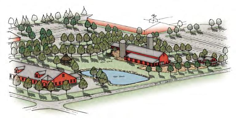
3 Auburn Lakes One of my first designs for an open space community is found on a 185-acre site in rural Auburn Township, Ohio. It emphasized clustering housing, providing walking trails, and integrating open space into the land plan. Facilities include a clubhouse, 12 man-made lakes, a picnic pavilion, hiking trails, tennis courts, chip and put green, two pools, and a beach area. I assisted with the coordination of zoning, all site planning, architecture and civil engineering, and assisted in securing County approvals. (Honor Award, Cleveland Garden Center Landscape Award Competition, Ohio Chapter ASLA)

4 Falls Pointe Falls Pointe is a 200-acre residential development consisting of single family lots, cluster homes, attached multifamily units, and open space. The open space amenities include recreational facilities, a clubhouse, and a five-acre lake. I was responsible for the overall site planning, coordination of the annexation and rezoning to a planned unit development, design of signage, master landscape design, and clubhouse area and pool design. A total of 525 residential units were planned, all of which are integrated into the fifty acres of overall open space.


5 The Groves Town Center I led the study of a 6000-acre site in DeSoto County, Florida, near Fort Meyers, to develop a new town showing different housing products, ranging from single-family housing to townhomes. We further detailed traffic systems to secondary roads and private drives to accommodate the housing, which totaled to approximately 10,300 units. The town center for the site plan of Desoto includes community facilities such as a fire department, a police department, a town hall, and libraries. Retail and commercial development locations were identified to support the residential areas, as well as locations for secondary retail and for educational facilities from primary school to high school. Open space was preserved as much as possible, incorporating nature preserves, natural greenways, athletic fields, an onsite sewage treatment plant, a 27-hole golf course, a biking/hiking trail, and churches.


6 The Groves Town Center My team developed a portion of the 6000-acre Groves Town Center site and produced circulation and land-use diagrams, which led to our conceptual design of traffic patterns and proposed circulation solutions. Housing product types included single-family cluster lots, multi-family housing, and town homes. Neighborhood amenities included a recreational facility, athletic fields, indoor accommodations, and an outdoor pool. The site plan was divided into sections for more detailed phasing. The first was to be developed into 586 single-family lots, where the typical lot size was 100 x 200.


7 Cypress Shadows I configured several schemes for the Cypress Shadows development in Bonita Springs, Florida, that included varying lot sizes, and maximizing open space. Some schemes included multi-family housing and recreation/community facilities. Stormwater management techniques were incorporated, which included the use of detention ponds and preserving wetland areas.


8 Fox Meadow Country Club I was responsible for the development of a golf course community master plan for this 550-acre site, located southeast of Medina, Ohio. I developed the golf course routing and worked closely with the golf course architect Steve Burns during the final design of the course and it s installation. The course was carefully integrated with single-family lots, detached cluster homes, and attached cluster homes. I led the team that was involved with the amendment of the existing zoning code for Montville Township to include cluster housing, reduced lot sizes, and green space recreational uses, such as golf courses as dedicated open space uses in residential developments.


9 Signature of Solon Country Club I was the lead land planner for this 305-acre private golf course community, developed by Cameratta Properties, including all land planning, golf course routing, and landscape & signage design. Sensitive planning allowed for harmonious residential development among the over 40 acres of existing wetlands. Virtually every one of the 155 residential lots fronts a fairway, green, or water feature of the championship length golf course. The main entrance to the community includes a colorfully planted boulevard aligned with the ninth green, which is surrounded by water on three sides. My company s services also included rezoning assistance to aid the client in achieving the passage of a referendum necessary for the continuation of the project.


10 Temple B nai Jeshurun The Linden Ceremonial Courtyard Renovation I designed, is a three-quarter of a million dollar replacement of an existing arrival courtyard for Temple B nai Jeshurun. The original courtyard was built in 1978, and needed to be completely replaced. The new courtyard includes: 16,100s.f. Plaza: Includes a Bima, as well as numerous benches, trees, and open space for informal gatherings and outdoor learning. Bima: An outdoor space allowing for outdoor religious services, life-cycle events, concerts, and other gatherings, featuring a movable ark, pulpit, and Torah reading table. 5,400s.f. Garden: Featuring trees, shrubs, and flowers, as well as benches and a sculpture, this space provides a place for tranquility and spiritual contemplation. River Jordan : A sculptural fountain that combines vegetation, water, and stone, providing an artistic and visual indicator of the entrance to the synagogue. Drop-off Canopy: Allows for sheltered drop-off of passengers.


11 University Hospitals Vision 2010 The UH Case Medical Center will bring state-of-the-art medical facilities to downtown Cleveland. Creating a campus setting for the new facilities has been a prime design goal. The new facility has the new 232 million dollar Seidman Cancer Center with a 1.8 million dollar healing garden, a 41 million dollar Center for Emergency Medicine, a 5 million dollar urban park and 25 million dollar parking garage. My design team worked together to integrate the new designs with the existing buildings and the Euclid Corridor streetscape, as well as make use of recycled site furnishings. I was responsible for all construction documents and for construction management for all five components during their installation.


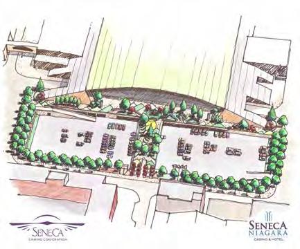
12 Seneca Casino I designed the plan for the renovated the western entrance plaza for Seneca Casino, in conjunction with complete deck renovation by Desman Associates. The plaza spans most of a city block, covering lower offices of the casino and bridging a lower parking lot from Third Street, to the front of the casino. Custom concrete paver modules, landscaping, seat walls, fencing, site furniture all define separate themed gardens framing the renovated rooftop casino entrance. The new tile paving pattern reflects the design of the hotel façade with triangular peaks, signifying both mountains, and also evergreen trees, which are revered symbols of the Seneca Nation. Project cost, $2,400,000.00


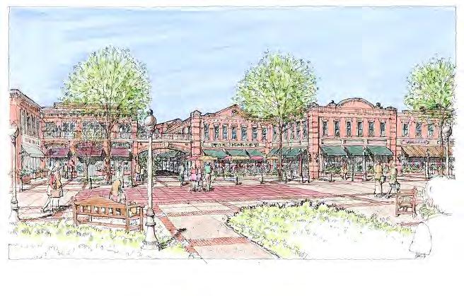
13 West Broad Streetscape I was a part of the team that developed the West Broad Streetscape Master Plan, a public space improvement plan for the historic U.S. Route 40/National Road. Cawrse & Associates scope of work for the project was to perform a detailed site inventory, develop proposed design programming, conduct public work sessions with local planning groups and to coordinate the approved design with Ohio Department of Transportation standards. Design elements include the reintroduction of historical elements of identity, while improving pedestrian safety and adding enhanced landscape design elements. From these program elements, we developed a final streetscape master plan. The final stage of this process was the preparation of construction documents for the streetscape improvements for implementation, along with a detailed construction cost estimates. The scope included 8,000 lineal feet of roadway in Franklin Township, and 8,000 lineal feet of roadway in Prairie Township, and the I-270 interchange.

14 Kendal of Oberlin Kendall at Oberlin is a $42 million dollar, 230-unit retirement community located on 100 acres of former farmland. The site plan clustered the buildings in order to preserve woodlands and wetlands, and maximize usable open space. Walking trails link the buildings together, and they are enhanced with new landscaping, mounding, and water features. Existing wetlands were augmented with additional native plantings, and new wetlands were created to fulfill on-site mitigation requirements. I developed the grading plan and planting plans for this project.


15 Cancer Care Healing Garden I developed the concept plan and construction documents for a rooftop cancer healing garden for MetroHealth Hospitals in Cleveland, Ohio. The first phase of this $350,000 healing garden was completed in This healing garden serves as an area of respite for patients receiving infusion treatments, their family, and also hospital staff of the cancer department. The garden is located over a parking garage that serves the entire grouping of four outpatient departments for MetroHealth.


16 Graphic Examples I believe that the designer cannot do everything on the computer. Often, the designer must be able to convey his or her design to the client with a quick sketch, using line weights, and sometimes color. These are examples of my graphic technique.


17 Photoshop Examples These images are examples of my Photoshop skills. Before and after shots of proposed work.
18 Perspective Examples These images are examples of my hand-rendered perspectives.
Town Center. Block 5 Existing multifamily residential units are expected to remain.
 Area Guidelines Germantown s districts should be developed as distinct communities with unique features that are supported through the guidelines. The guidelines not only help distinguish these districts
Mariposa Lakes. Planned Community. Project Overview. Stockton, CA
 Planned Community Stockton, CA Project Overview March 2007 Summary of Proposed Community is a master-planned community proposed for development on approximately 3,810 acres in southeast Stockton. In 2004,
This is the East Carolina University Comprehensive Facilities Master Plan Final Draft Plan Review. This workbook reviews the campus draft master plan
 This is the East Carolina University Comprehensive Facilities Master Plan Final Draft Plan Review. This workbook reviews the campus draft master plan first presented on campus on June 29 and June 30, 2011.
B L A C K D I A M O N D D E S I G N G U I D E L I N E S for Multi-family Development
 B L A C K D I A M O N D D E S I G N G U I D E L I N E S for Multi-family Development Adopted June 18, 2009 This section of the Design and focuses on site planning and design guidance for new multi-family
RESIDENTIAL + MIXED USE CONNECTING PEOPLE
 RESIDENTIAL + MIXED USE CONNECTING PEOPLE 2900 On First, Seattle, WA CARDUCCI ASSOCIATES PROFILE Founded in 1976, Carducci Associates is a professional landscape architecture and planning firm based in
KASPER. City of Georgetown, Texas PUD Planned Unit Development. December 30, 2015 Revised January 27, 2016
 KASPER City of Georgetown, Texas PUD Planned Unit Development December 30, 2015 Revised January 27, 2016 Applicant: Sentinel Land Company, LLC 4910 Campus Drive Newport Beach, CA Prepared by: SEC Planning
LANDSCAPE ARCHITECTURE - NEW JERSEY
 LANDSCAPE ARCHITECTURE - NEW JERSEY MD ANDERSON CANCER CENTER AT COOPER ROOFTOP GARDEN Camden NJ Cooper University Hospital Landscape Architecture Langan provided comprehensive planning design and construction
Seneca Meadows. Block 4 Locate office, technology, and medical development adjacent to I Screen views of garage structures from I-270.
 Seneca Meadows Seneca Meadows has an industrial park in its southern end and a mixed-use employment area planned for the north end. The district benefits from extensive I-270 visibility, stream valley
Lehigh Acres Land Development Regulations Community Planning Project
 Lehigh Acres Land Development Regulations Planning Effort Summary In July, 2010 Commissioner Frank Mann invited the Lehigh Acres community to start discussing how to achieve their recently adopted community
BURTON STATION STRATEGIC GROWTH AREA PLAN UPDATE PUBLIC MEETING 3/26/18
 BURTON STATION STRATEGIC GROWTH AREA PLAN UPDATE PUBLIC MEETING 3/26/18 1 WHERE WE ARE? 2 PRIMARY OBJECTIVES OF THE PLAN UPDATE 1. Update the land use designation for Burton Station Village to reflect
VEHICULAR AND PEDESTRIAN CIRCULATION
 This perspective sketch communicates the intended character and quality of a proposed streetscape design. Locate benches near a major intersection where people tend to gather. Seating and lighting provide
Community Design Plan
 Gardena General Plan 2006 Authority While the is not a required element of a General Plan, it is included because improving the community appearance and image is paramount to the overall quality of life
Community Mixed Use Zone Districts (CMU)
") 18.28.500 Community Mixed Use Zone Districts (CMU) The Community Mixed Use Zone Districts (CMU) are intended to help implement the land use goals and strategies found in the Golden Vision 2030 values,
18.28.500 Community Mixed Use Zone Districts (CMU) The Community Mixed Use Zone Districts (CMU) are intended to help implement the land use goals and strategies found in the Golden Vision 2030 values,
Chapter 6. Overall Vision RECOMMENDATIONS. More Trail and Trail. Connections. Equal Access to Park. Facilities and Programs. Water Access.
 Overall Vision More Trail and Trail Connections Equal Access to Park Facilities and Programs Water Access Environment Variety Chapter 6 RECOMMENDATIONS Chapter 6 The following recommendations for park,
ATTACHMENT A. SILVERDALE DESIGN STANDARDS Amendments to the Waaga Way Town Center Chapter
 ATTACHMENT A SILVERDALE DESIGN STANDARDS Amendments to the Waaga Way Town Center Chapter Chapter 10. Waaga Way Town Center 10.1 Physical Identity Elements & Opportunities The Waaga Way Town Center includes
Charles P. Johnson and Associates. Annapolis Landscape Architects
 Charles P. Johnson and Associates Annapolis Landscape Architects AGENDA Introduction Project Limits and Scope Site Analysis Opportunities & Constraints Program Goals Image Boards Design Alternatives Pros
Policies and Code Intent Sections Related to Town Center
 Policies and Code Intent Sections Related to Town Center The Town Center Vision is scattered throughout the Comprehensive Plan, development code and the 1994 Town Center Plan. What follows are sections
3.0 master plan concept
 3.0 master plan concept 3.1 introduction The purpose of the Huron Church Road Master Plan Concept is to provide an overview of the Master Plan design process, identify preliminary streetscape installations
Throughout. square. (Crystal City Vision Plan 2050)
") 1: Terms related to the PSMP document 1 public space (see also public realm, civic space) An open space designated on the regulating plan, accessible to all, including Plazas, Mini Parks, and Neighborhoods
1: Terms related to the PSMP document 1 public space (see also public realm, civic space) An open space designated on the regulating plan, accessible to all, including Plazas, Mini Parks, and Neighborhoods
Dowdy Park. Concept Plans TOWN OF NAGS HEAD NORTH CAROLINA. Developed by: Albemarle & Associates, Ltd VHB/ Vanasse Hangen Brustlin, Inc.
 TOWN OF NAGS HEAD NORTH CAROLINA Concept Plans Developed by: Albemarle & Associates, Ltd VHB/ Vanasse Hangen Brustlin, Inc. Site Looking Southeast Dowdy Park Existing Conditions Nags Head Woods Sound Future
BUSINESS DISTRICT DESIGN GUIDELINES
 Des Plaines, Illinois Prepared for the City of Des Plaines by: The Lakota Group Laurie Marston, AICP March 2005 Section 5: Streetscape Elements Business District Design Guidelines STREETSCAPE ELEMENTS
APPENDIX C. Architectural and Environmental Design Standards. Environmentally sensitive areas should be protected.
 APPENDIX C Architectural and Environmental Design Standards Environmentally Sensitive Areas Goal A. Environmentally sensitive areas should be protected. Development, such as roads, houses, and other structures,
Design Guidelines for the Route 30 Corridor Master Plan: Subdivision and Land Development Elements
 Design Guidelines for the Route 30 Corridor Master Plan: Subdivision and Land Development Elements East Whiteland Township- Chester County, PA Prepared by: Draft: May 7, 2018 Design Guidelines for the
ELK GROVE TOWN CENTER DESIGN GUIDELINES
 ......... ELK GROVE TOWN CENTER DESIGN GUIDELINES LAGUNA RIDGE SPECIFIC PLAN... June 2008 ............ DESIGN GUIDELINES Table of Contents Contents Section A: Town Center Overview...1 A.1. Purpose and
PUBLIC RIGHT-OF-WAY IN THIS CHAPTER PUBLIC REALM
 PUBLIC RIGHT-OF-WAY This section provides design guidelines for improvements in the public right-of-way. The public right-of-way refers to streets, sidewalks, non-vehicular thoroughfares, parks and greenways
PINE CURVE REZONING. Property does not meet criteria for open space preservation and is not a candidate for a park
 PINE CURVE REZONING BACKGROUND Purchased as two parcels in 2001 and 2002 Annexed and Zoned Greater Downtown District Historic Center September 25, 2002 and October 7, 2002 WHAT THE PROJECT IS AND IS NOT
Greater East Wenatchee Urban Growth Area. Design Standards & Guidelines
 Greater East Wenatchee Urban Growth Area Design Standards & Guidelines November 30, 2006 Table of Contents General Guidelines for All Development Site Design - - - - - - - - - - - - - - - - - - - - - -
Corridor Identity. Section 9. Introduction. Corridor Guiding Principles
 Corridor Identity An attractive and healthy community is a critical element of a quality place, and the design of quality places is a balance between environmental, economic, and social considerations.
ARCHITECTURAL ALLIANCE LANDSCAPE WINTER
 ARCHITECTURAL ALLIANCE LANDSCAPE WINTER 2015 COMPANY PROFILE Formed in 1991, Architectural Alliance Landscape is a mid-sized firm in business in South Florida for over 24 years. Our goal is to bring new
4 C OMMUNITY D ISTRICTS
 4 C OMMUNITY D ISTRICTS N ew development in the Area will include many different types of land uses, including a destination retail area that attracts people from all over the region; recreation opportunities
SECTION UNIFIED DEVELOPMENT ORDINANCE SECTION Part 1 Ordinance. ARTICLE 1 Zoning Districts
 SECTION 1-100 UNIFIED DEVELOPMENT ORDINANCE SECTION 1-300 Part 1 Ordinance SECTION 1-100. Introduction. ARTICLE 1 Zoning Districts Crystal Lake strives to maintain a balance of various land uses for a
3.1 community vision. 3.3 required plan elements
 Chapter 3 Community Form 3.1 community vision 3.2 Parks & landscaping concepts 3.3 required plan elements D R A F T 20 Community Form Chapter 3 3.0 Community form 3.1 community vision The Specific Plan
Planning Districts INTRODUCTION
 INTRODUCTION To facilitate detailed examination of development prospects for all areas of the community, Delano has been divided into 14 planning districts. The location of these planning districts is
URBAN DESIGN + PLANNING BRIDGING COMMUNITIES
 URBAN DESIGN + PLANNING BRIDGING COMMUNITIES East Pleasanton, Pleasanton, CA CARDUCCI ASSOCIATES PROFILE Founded in 1976, Carducci Associates is a professional landscape architecture and planning firm
Standards (R-3) Figure B-11: R-3 Residential Standards Exhibit
 Figure B-11: R-3 Residential Standards Exhibit") Avila Ranch Avila Ranch Specific Plan Development Standards High Medium Density - High Residential Density Residential Lot and Building Lot and Standards Building (R-3) Standards (R-3) EXAMPLES These sketches
Avila Ranch Avila Ranch Specific Plan Development Standards High Medium Density - High Residential Density Residential Lot and Building Lot and Standards Building (R-3) Standards (R-3) EXAMPLES These sketches
UNIVERSITY OF MICHIGAN:
 Chapter Eight UNIVERSITY OF MICHIGAN: North Campus I. Introduction The University of Michigan currently owns approximately 800 acres of land in the northeast section of Ann Arbor. North Campus refers to
Master Site Development Plan (MSDP) Rocky View County Campus at Balzac East
 Rocky View County Campus at Balzac East") Master Site Development Plan (MSDP) Rocky View County Campus at Balzac East Balzac East, Alberta July 2009 CONTENTS 1.0 purpose 1 2.0 guiding principles 2 3.0 site description 3 4.0 site analysis and county
Master Site Development Plan (MSDP) Rocky View County Campus at Balzac East Balzac East, Alberta July 2009 CONTENTS 1.0 purpose 1 2.0 guiding principles 2 3.0 site description 3 4.0 site analysis and county
PORTFOLIO
 SARAE13@GMAIL.COM PORTFOLIO Education Fall 2005 - Present Fall 1998 - May 2003 Employment Jan. 2008 - May 2008 Fall 2007 Fall 2006 - present Summer 2006 and 2007 Aug. 2006 - May 2007 Sept. 2003 - Sept.
Goal 1: To Encourage the Orderly, Harmonious and Judicious Use of University Resources in the Development of University Land.
 2.0 Future Land Use Goal 1: To Encourage the Orderly, Harmonious and Judicious Use of University Resources in the Development of University Land. Objective 1.1: Make available future building sites that
Terra Vida II Apartments
 Terra Vida II Apartments Project Development Plan Application and Narrative September 4, 2013 Prepared by Milestone Development Group 1 TABLE OF CONTENTS PROJECT DIRECTORY 3 LIST OF OFFICERS/DIRECTORS
599 Kennedy Road - Official Plan Amendment and Zoning Amendment Application - Preliminary Report
 STAFF REPORT ACTION REQUIRED 599 Kennedy Road - Official Plan Amendment and Zoning Amendment Application - Preliminary Report Date: March 7, 2017 To: From: Wards: Reference Number: Scarborough Community
Application Number: SD Project Name: Walton Farms Preliminary Subdivision (acting as Master Plan)
") STAFF REPORT Town of Clayton Planning Department 111 E. Second Street, Clayton, NC 27520 P.O. Box 879, Clayton, NC 27528 Phone: 919-553-5002 Fax: 919-553-1720 Planning Board May 22, 2017 Application Number:
STAFF REPORT Town of Clayton Planning Department 111 E. Second Street, Clayton, NC 27520 P.O. Box 879, Clayton, NC 27528 Phone: 919-553-5002 Fax: 919-553-1720 Planning Board May 22, 2017 Application Number:
Appendix 1. Private Projects with Respective On Site PUS and Public Parks in the Silver Spring CBD
 Appendix 1 Private Projects with Respective On Site PUS and Public Parks in the Silver Spring CBD Green Space Guidelines for the Silver Spring Central Business District montgomery county planning board,
DRAFT ROOSEVELT ROAD. District Recommendations. Figure 5.23 The Roosevelt Road Corridor
 CHAPTER 5 Figure 5.23 The Road Corridor Road will develop as a mixed-use corridor, emphasizing regional retail, west of the river and mixed-use development east of the river. KEY RECOMMENDATIONS 1. High
Vision Statement for the Town of Flower Mound Master Plan The Town of Flower Mound Master Plan furthers the established community based vision to:
 Vision Statement for the The furthers the established community based vision to: Preserve the country atmosphere and natural environment that makes Flower Mound a unique and desirable community; Mitigate
New Park / Entry Court & Plaza Concept Design
 New Park / Entry Court & Plaza Concept Design The SECC Public realm is proposed to have a focus on health, wellness, and community and that site users will include patrons of the neighbourhood. The block
Chapter Purpose and Intent. 7.2 Applicability. 7.3 General Provisions RECREATIONAL OPEN SPACE
 Chapter 7. RECREATIONAL OPEN SPACE 7.1 Purpose and Intent The intent of this Chapter is to provide for centrally located, unencumbered land as neighborhood recreational open space and not to permit the
MEETING MINUTES East Carolina University Comprehensive Master Plan Page 1 of 1
 Page 1 of 1 26472.J00 04.06.2009 04.24.2009 PROJECT PROJECT NO. MEETING DATE ISSUE DATE Health Sciences Building Open House-West Campus Location MEETING LOCATION MEETING PURPOSE Ryan Podvin ISSUED BY SIGNATURE
July 12, Columbus City Council City Hall 90 West Broad Street Columbus, OH RE: I-70/71 Columbus Crossroads Project
 OHIO DEPARTMENT OF TRANSPORTATION DISTRICT 6 400 EAST WILLIAM STREET DELAWARE, OHIO 43015 800.372.7714 Columbus City Council City Hall 90 West Broad Street Columbus, OH 43215-9015 RE: I-70/71 Columbus
GPA FALL 2017 CONFERENCE
 Change in Doraville Doraville at the beginning of a new era Design Doraville (Comp. Plan) adopted in 2016 Doraville Town Center Masterplan LCI (2005) Downtown Doraville Masterplan LCI (2010) 2014 Adoption
The following concept plans and illustrations are the result of this 10 month study of the alley connections from CSU to the River District.
 W E L C O M E T O T H E F O R T C O L L I N S D O W N T O W N A L L E Y S A N D I N T E G R AT E D W A L K W AY S M A S T E R P L A N O P E N H O U S E The following concept plans and illustrations are
The Village. Chapter 3. Mixed Use Development Plan SPECIFIC PLAN
 The Village SPECIFIC PLAN Chapter 3 3.1 INTRODUCTION 3.1.1 Purpose This Chapter describes the development regulations applicable to the Mixed-Use and Transit Center Planning Areas. These form-based regulations
APPENDIX 4 NEWBURY TOWNSHIP TOWN CENTER MASTER PLAN
 APPENDIX 4 NEWBURY TOWNSHIP TOWN CENTER MASTER PLAN Prepared by the Urban Design Center of Northeast Ohio September, 2008 Newbury Township Land Use Plan A4-1 INDEX Page No. 1 Newbury Township Town Center
SECTION TWO: Urban Design Concepts
 SECTION TWO: Urban Design Concepts The Gardnerville Plan for Prosperity shapes economic opportunities presented by regional growth. The Urban Design Concepts provide policies and concepts for land use,
U n i v e r s i t y o f S o u t h C a r o l i n a A i k e n. Land Plan Study
 U n i v e r s i t y o f S o u t h a r o l i n a A i k e n Land Plan Study 06.27.2008 Goals ampus Growth Develop a Land Plan that allows for the orderly expansion of the campus over the next ten years and
RZC Public View Corridors and Gateways
 RZC 21.42 Public View Corridors and Gateways 21.42.010 Purpose 21.42.020 Scope and Authority 21.42.030 Administration 21.42.040 Gateways Design 21.42.050 Unidentified Public Views 21.42.060 Identification
The transportation system in a community is an
 7 TRANSPORTATION The transportation system in a community is an important factor contributing to the quality of life of the residents. Without a sound transportation system to bring both goods and patrons
L a n d s c a p e A r c h i t e c t s & P l a n n e r s. imagine. create. solutions
 imagine. create. solutions imagine. create. solutions RSLA is an award-winning Landscape Architecture & Planning fi rm with studios on Long Island, New York and in Chesapeake, Virginia. Our mission is
Division VI Community Mixed Use (CMU) Architectural Guidelines and Standards
 Architectural Guidelines and Standards") Division VI 18.40.800 Community Mixed Use (CMU) Architectural Guidelines and Standards 18.40.810 Guidelines The goals of the Comprehensive Plan include a focus on pedestrian safety, amenities and aesthetics
Division VI 18.40.800 Community Mixed Use (CMU) Architectural Guidelines and Standards 18.40.810 Guidelines The goals of the Comprehensive Plan include a focus on pedestrian safety, amenities and aesthetics
EXISTING CONDITIONS 41. Existing Conditions
 EXISTING CONDITIONS 41 Existing Conditions The Existing Analysis phase of the planning process involved a study of the existing conditions on the campus in order to identify key planning issues to be addressed
4. INDUSTRIAL 53 CASTLE ROCK DESIGN
 4. INDUSTRIAL 53 CASTLE ROCK DESIGN CASTLE ROCK DESIGN 54 4. INDUSTRIAL Overview Well-designed and attractive industrial centers are the product of blending economic realities with both functional and
SUBCHAPTER 4-B GUIDELINES FOR THE B-3 COMMERCIAL CHARACTER AREA
 1 SUBCHAPTER 4-B GUIDELINES FOR THE B-3 COMMERCIAL CHARACTER AREA Downtown Bozeman should be the location of buildings of greatest height and intensity in the community. The following guidelines apply
ACSA/AIA Housing Design Education Award
 ACSA/AIA Housing Design Education Award 2014-2015 Winner: Submission Materials FOUR URBAN HOUSING NARRATIVES: Getting the City to be a Master Developer STEPHEN D. LUONI University of Arkansas JEFFREY ERWIN
The open space system should provide connective elements, relate to natural resources, and enhance the suburban character of the landscape..
 The open space system should provide connective elements, relate to natural resources, and enhance the suburban character of the landscape.. Mixed-use and infill development should maintain or enhance
Tonight s Agenda. Disbrow Park & Facilities Master Plan
 Disbrow Park & Facilities Master Plan Public Outreach Forum City of Rye, NY May 11, 2017 Tonight s Agenda. Break (10 min) Introduction: What s in the works? Stantec Presentation - Goals and objectives
CHAPTER FIVE COMMUNITY DESIGN
 CHAPTER FIVE COMMUNITY DESIGN CHAPTER FIVE - COMMUNITY DESIGN Assumptions Frazier Park and Lebec have historically developed according to different patterns of spatial form. While both communities are
Angela M. Bollinger. architecture & interior design project management facilities management PORTFOLIO
 Angela M. Bollinger architecture & interior design project management facilities management PORTFOLIO 2016 Outdoor Recreation Sport Complex Create a new Outdoor Recreation Sports Complex for NIU Campus
Parker Pine Curve Master Plan January 28th, 2009, Public Workshop Comments
 Group 1 Big Ideas Pedestrian friendly within and to development - bridge over Main Street from downtown. Campus feel. Parking garage like Castle Rocks - Taj garage may be tucked in hillside. Large (big
COMMUNITY DESIGN. GOAL: Create livable and attractive communities. Intent
 COMMUNITY DESIGN Intent An attractive, well-designed County will attract quality development, instill civic pride, improve the visual character of the community, and create a strong, positive image for
Today Land & People. Northeast Nampa Gateway District. Employment. Land Use Characteristics. Demographics. Current Zoning
 Today Land & People Employment Major employers include Saint Alphonsus, the College of Western Idaho, the Auto Mall, Sorrento Lactalis and Walmart. 3,004 jobs in 2010 (COMPASS-CIM 2040 TAZ data) 4,345
Zoning Interface: Districts and Forms for Sioux Falls Zoning Ordinance
 Zoning Interface: Districts and Forms for Sioux Falls Zoning Ordinance For more information about each form, click on the associated link. Single-Family Residential Districts RR Rural Residential RS Single-Family
DRAFT. Waterfronts and Open Spaces. 10 The Riverfront Open Space System
 CHAPTER 4 Waterfronts and Open Spaces 10 The Riverfront Open Space System 12 Planned, proposed and envisioned riverfront recommendations. Figure 4.3.23 The riverfront will become a major new public amenity
(DC1) Direct Development Control Provision DC1 Area 4
 Direct Development Control Provision DC1 Area 4") . General Purpose (DC) Direct Development Control Provision DC Area 4 The purpose of this Provision is to provide for an area of commercial office employment and residential development in support of the
. General Purpose (DC) Direct Development Control Provision DC Area 4 The purpose of this Provision is to provide for an area of commercial office employment and residential development in support of the
EXISTING VEHICULAR & PEDESTRIAN CIRCULATION
 46 EXISTING CONDITIONS EXISTING VEHICULAR & PEDESTRIAN CIRCULATION Vehicular and pedestrian circulation patterns are illustrated on this graphic. Campus entry points and major vehicular circulation routes
FLORIN ROAD CORRIDOR Site Plan and Design Review Guidelines Checklist
 FLORIN ROAD CORRIDOR Site Plan and Design Review Guidelines Checklist Applicant s Name: Project Address: Phone: Email: Applicant shall fill out the design guidelines checklist for all guidelines applicable
RESIDENTIAL PLANNED UNIT DEVELOPMENT / SUBDIVISION AND REZONING CONCEPT AND DEVELOPMENT STAGE PLAN SUBMITTAL NARRATIVE
 RESIDENTIAL PLANNED UNIT DEVELOPMENT / SUBDIVISION AND REZONING CONCEPT AND DEVELOPMENT STAGE PLAN SUBMITTAL NARRATIVE DEVELOPMENT TEAM DONEGAL SOUTH Maple Grove, Minnesota March 27, 2017 Applicant/Developer/Builder:
V. Gateways GATEWAYS / V-1
 V. GATEWAYS / V-1 Many of Chesapeake s gateways are located on highways and call for bold and attractive designs that motorists can understand, appreciate, and enjoy. can also take the form of natural
Tel: (705) Fax: (705)
 Fax: (705)") 521 and 525 Essa Road City of Barrie Tel: (705) 812-3281 Fax: (705) 812-3438 Email: INFO@IPSCONSULTINGINC.com 1 5 0 D U N L O P S T R E E T E A S T, S U I T E 2 0 1, B A R R I E O N T A R I O L 4 M 1 B
521 and 525 Essa Road City of Barrie Tel: (705) 812-3281 Fax: (705) 812-3438 Email: INFO@IPSCONSULTINGINC.com 1 5 0 D U N L O P S T R E E T E A S T, S U I T E 2 0 1, B A R R I E O N T A R I O L 4 M 1 B
7-PARKS, OPEN SPACE & PUBLIC ART
 7-s, Open Space & Public Art 7-PARKS, OPEN SPACE & PUBLIC ART This chapter provides recommendations for the expansion of new parks, plazas and open space that serve the many user groups targeted for downtown.
Staff Report to the North Ogden City Planning Commission
 Staff Report to the North Ogden City Planning Commission SYNOPSIS / APPLICATION INFORMATION Application Request: Concept review on a legislative application to rezone land located at approximately 1750
Metro. Activity Center Design Guidelines. Recommendations For Developing Focused, Mixed-Use Commercial/Residential Centers
 Metro Activity Center Design Guidelines Recommendations For Developing Focused, Mixed-Use Commercial/Residential Centers Metro Activity Centers What is a MAC? Legacy, the adopted guide for the future growth
REDMOND CENTRAL CONNECTOR ART & DESIGN MASTER PLAN
 REDMOND CENTRAL CONNECTOR ART & DESIGN MASTER PLAN Redmond Central Connector Master Plan design principles principles make it redmond: past, present, future not just a place with art, a place that is art
WINDSOR GLEN DESIGN GUIDELINES
 WINDSOR GLEN DESIGN GUIDELINES Adopted by Council, 2006 WINDSOR GLEN REDEVELOPMENT DESIGN GUIDELINES August 2006 1.0 Master Plan Organization For this area of the Coquitlam Town Centre, a mix of high,
Blue Line LRT Extension
 v e Noble Pkwy Noble Pkwy Xerxes Ave N Shingle Creek Penn Ave N Penn Ave N Fremont Ave N Lyndale Ave N S Washington Ave University Ave NE Blue Line LRT Extension LIGHT RAIL PLATFORM AND STATION DESIGN
Jewel. Platte. of the. Plattsmouth Main Street Landscape Architecture by HDR
 Jewel of the Platte Plattsmouth Main Street Landscape Architecture by HDR Plattsmouth, Nebraska is a historic community of 6,500 residents located along the west bank of the Missouri River, just south
Garden edges provide vertical plantings to buffer the neighbors from the building facilities around the entire campus.
 Open Space Existing Open Space Children s intends to maintain the landscape as a garden around the campus to help children heal while providing spaces for visitors, caregivers, staff and neighbors. Children
Gold Line Bus Rapid Transit Transit Oriented Development (BRTOD) Helmo Station Area Plan
 Helmo Station Area Plan") Appendix F Gold Line Bus Rapid Transit Transit Oriented Development (BRTOD) Helmo Station Area Plan Introduction and Purpose of the Plan The Gold Line Bus Rapid Transit facility is an eleven-mile dedicated
Appendix F Gold Line Bus Rapid Transit Transit Oriented Development (BRTOD) Helmo Station Area Plan Introduction and Purpose of the Plan The Gold Line Bus Rapid Transit facility is an eleven-mile dedicated
City of Heath. Town Center Concept
 In the give-and-take of getting projects designed, financed, and approved, the famous refrain from the film Field of Dreams is heard often: if you build it, they will come. From the perspective of the
ALTERNATIVE STATION AREA -
 ALTERNATIVE STATION AREA - THE 10 TH STREET GARDEN STATION Two alternative land use scenarios and designs are illustrated here: Scheme A - Transit-Oriented Development High to Mid-Density Residential /Office
TURN TO THE RIVER CITY PLAZA LANDSCAPE DESIGN CONCEPT May 25, 2016
 Turn to the River is a multi-year project of Art Spaces - Wabash Valley Outdoor Sculpture Collection, Inc. to connect downtown Terre Haute with the Wabash River through public art and design. The four-square
Final Master Plan and Development Control Regulations
 1. INTRODUCTION CHECK LIST a. Introduction b. Table of contents c. Definitions. d. scope of works. 2. FINAL OVERALL MASTER PLAN a. SITE ANALYSIS and OVERVIEW: i. Existing and Proposed Site Plan Levels.
Spencer J Nickel, RLA, ASLA. Landscape Architecture
 Spence is a landscape architect, designer and campus planner whose diverse set of creative and technological skills allow him to bring passion, meaning and artistic sensibility to the design of broad,
A Vibrant Downtown. Chapter 5 Cary Public Art Opportunities 31
 A Vibrant Downtown Cary s vision for Downtown is a unique, vibrant, dynamic, pedestrian friendly location; a regional destination and a place to live, work, and recreate, according to the 2001 Town Center
KEY MAP DEVELOPMENT PERMIT AREA MAP. Sunnymede North Sub-Area Plan
 Richmond Official Community Plan BROADMOOR AREA SUNNYMEDE NORTH SUB-AREA PLAN Bylaw 7100 Schedule 2.6C SUNNYMEDE NORTH SUB-AREA PLAN SUNNYMEDE NORTH SUB-AREA PLAN SUNNYMEDE NORTH SUB-AREA PLAN KEY MAP
East Whiteland Township Current Land Development Projects
 Current Land Development Projects A. Lincoln Court (Lancaster Avenue / Malin Road) Demolish existing 2 story brick and stucco structure Build onto existing 1 story masonry shopping center to add 8 new
VILLAGE OF SKOKIE Design Guidelines for Mixed-Use Districts NX Neighborhood Mixed-Use TX Transit Mixed-Use CX Core Mixed-Use
 VILLAGE OF SKOKIE Design Guidelines for Mixed-Use Districts NX Neighborhood Mixed-Use TX Transit Mixed-Use CX Core Mixed-Use TABLE OF CONTENTS CHAPTER 1 SITE DESIGN Purpose 1 CHAPTER 2 SITE DESIGN Streetscape
Appendix A. Park Land Definitions
 Appendix A Park Land Definitions Mini Park May serve specific function for any and all ages, depending on need of the user area. Size range 1-5 acres with optimum size being 3 acres. Service area is sub-neighborhood
CHAPTER FOUR: DEVELOPMENT AND DESIGN
 CHAPTER FOUR: DEVELOPMENT AND DESIGN 4.1 Introduction This Chapter presents development and design plans and guidelines, including design concepts for focus areas, and states implementation measures for
2011 ASLA Design Awards. Centennial Park Merit Award Design Concepts CLA, Inc. Design over $500,000 Construction Budget
 2011 ASLA Design Awards Centennial Park Merit Award Design Concepts CLA, Inc. Design over $500,000 Construction Budget 2011 ASLA Colorado Professional Design Awards Project Name: Category: Location: Const.
40 Years of Smart Growth Arlington County s Experience with Transit Oriented Development in the Rosslyn-Ballston Metro Corridor
 40 Years of Smart Growth Arlington County s Experience with Transit Oriented Development in the Rosslyn-Ballston Metro Corridor A presentation by the Arlington County Department of Community Planning,