Town of Oshkosh Smart Growth Comprehensive Plan
|
|
|
- Edgar Powers
- 6 years ago
- Views:
Transcription


1 Town of Oshkosh Smart Growth Comprehensive Plan Planning for 2020 and Beyond Adopted June 2003
2 TABLE OF CONTENTS 1.0 Introduction...1 Includes a location map, town planning history, summary of the Wisconsin Smart Growth Law, public involvement activities, and town values. 2.0 Issues and Opportunities...7 Chapter highlights include the a community survey discussion and vision statements 3.0 Community Profile...17 Relevant data (mostly from U.S. Census) describing the town s population characteristics, trends and projections. 4.0 Housing Element...31 A profile of local housing types, conditions, needs, goals and objectives. 5.0 Transportation Element...42 A description of the roads, trails and other transportation facilities in the Town of Oshkosh. The chapter summarizes local, county, regional and state plans, needs, goals and objectives. 6.0 Utilities and Community Facilities...64 A comprehensive description of the public and private utilities and community facilities available in Freedom, including: schools, electricity, parks, sanitary sewer, police, and fire protection. The chapter concludes with a series of goals and objectives. 7.0 Agricultural, Natural and Cultural Resources...93 The chapter discusses the importance and challenges of farming. Also included in this chapter is a description of natural resources and cultural amenities. The chapter concludes with a series of goals and supporting objectives that seek to protect natural resources and farming operations. 8.0 Economic Development The local economy is the subject of this chapter. The long-term importance of farming and local strengths, weaknesses and opportunities for other forms of economic development are the focus of the text. 9.0 Existing Land Use A profile of existing land uses, trends, and regulations (including zoning) in the Town of Oshkosh.
3 10.0 Future Land Use This chapter presents the 10- and 20-Year Future Land Use Maps. Also provided in this chapter is a discussion about how the maps should be used and special sections related to particular land uses, including: quarries, environmental corridors, natural gas peaking plants, and conservation subdivisions Intergovernmental Cooperation A discussion of the Town of Oshkosh s relationship with neighboring communities, Winnebago County, the school districts, sanitary districts, the ECWRPC, and various state agencies Implementation All of the previously presented goals and objectives are provided in this chapter along with milestone dates to measure progress in plan implementation efforts. Appendix A: Record of Public Involvement Appendix B: Common Planning Acronyms Appendix C: Community Survey Results Appendix D: Public Participation Plan Appendix E: Population Projections Appendix F: Majority Opinion Map Appendix G: Natural Limitations for Building Site Development Maps Appendix H: Additional Resources
4 1.0 INTRODUCTION Location The Town of Oshkosh is located in east-central Winnebago County, Wisconsin, immediately adjacent to the City of Oshkosh. USH 41, CTY A and USH 45 traverse the town and provide easy access for residents to nearby employment centers in Oshkosh and the Fox Cities. The primary areas of commercial and industrial development in the Town of Oshkosh are located along USH 41, Green Valley Road (USH 41 frontage road) and CTH A (extending between CTH Y and the town s northern boundary). Many of the properties in these areas are undeveloped. In addition to providing the town with long-term planning guidance, this plan will be an important tool to influence the development of these areas. The Town of Oshkosh enjoys significant areas of shoreline along Lake Winnebago and Lake Butte Des Morts. Both of these lakes are valuable assets to the town from a recreational and economic standpoint. Background The Comprehensive Plan for the Town of Oshkosh was developed primarily to manage future growth. The Town of Oshkosh has seen a fair amount of development in its sanitary districts and near USH 41 in recent years. However, the town has also experienced extensive annexation pressure from the City of Oshkosh, which has resulted in the loss of several hundred acres of land. Developing this plan sends a clear message that the Town of Oshkosh wishes to act proactively to set its own ground rules for the types of development that will benefit the town, maintain a rural atmosphere and still provide flexibility for landowners. To prepare residents for comprehensive planning, town leaders sought assistance from Mike Koles, UW-Extension Agent for Winnebago County. Mr. Koles facilitated an extensive program, which included the formation of the Planning Advisory Committee, education about the Smart Growth Law, and important land use issues facing the Town of Oshkosh. Moreover, the education program also included the preliminary development of a draft vision statement and identification of strengths and opportunities to address in the plan. During this initial education phase of the planning program, the Town of Oshkosh developed a successful application for a Wisconsin Department of Administration Comprehensive Planning Grant. Town of Oshkosh Comprehensive Plan Introduction Chapter 1.0 1

5 Purpose and Scope of This Document This 20-year Comprehensive Plan for the Town of Oshkosh, includes four major components: A profile of the demographic, economic and housing characteristics of the town; An inventory and assessment of the environment, community facilities, and natural resources; Visions, goals, objectives and implementation strategies; and A land use map that depicts the future land use patterns in the town. This plan was developed under the authority of 1999 Wisconsin Act 9, Wisconsin s Smart Growth Law. The law requires that a 20-year comprehensive plan be developed and adopted by all units of government that wish to have a role in land use issues. The law authorizes municipalities to prepare and adopt comprehensive plans to serve as guides for the development of their communities. The law also authorizes multi-jurisdictional planning efforts. The Smart Growth Law defines, for the first time, what is meant by a comprehensive plan in Wisconsin. It includes nine (9) required elements. These are: 1) Issues and Opportunities 2) Housing 3) Transportation 4) Utilities and Community Facilities 5) Agricultural, Natural and Cultural Resources 6) Economic Development 7) Intergovernmental Cooperation 8) Land Use 9) Implementation In addition, the state requires that these elements be developed in concert with Wisconsin s 14 goals for local planning, which are: 1) Promotion of the redevelopment of lands with existing infrastructure and public services and the maintenance and rehabilitation of existing residential, commercial and industrial structures. 2) Encouragement of neighborhood designs that support a range of transportation choices. 3) Protection of natural areas, including wetlands, wildlife habitats, lakes, woodlands, open spaces and groundwater resources. 4) Protection of economically productive areas, including farmland and forests. 5) Encouragement of land uses, densities and regulations that promote efficient development patterns and relatively low municipal, state governmental and utility costs. Town of Oshkosh Comprehensive Plan Introduction Chapter 1.0 2
6 6) Preservation of cultural, historic and archeological sites. 7) Encouragement of coordination and cooperation among nearby units of government. 8) Building of community identity by revitalizing main streets and enforcing design standards. 9) Providing an adequate supply of affordable housing for individuals of all income levels throughout each community. 10) Providing adequate infrastructure, public services and an adequate supply of developable land to meet existing and future market demand for residential, commercial and industrial uses. 11) Promoting the expansion or stabilization of the current economic base and the creation of a range of employment opportunities at the state, regional and local levels. 12) Balancing individual property rights with community interests and goals. 13) Planning and development of land uses that create or preserve varied and unique urban or rural communities. 14) Providing an integrated, efficient and economical transportation system that affords mobility, convenience, and safety that meets the needs of all citizens, including transitdependent and disabled citizens. Public Involvement The Town of Oshkosh Comprehensive Plan was developed in an environment rich with public input. To gain citizen understanding and support throughout the planning program, the public was provided with meaningful opportunities to become involved in the process. Public input was facilitated through several meetings and activities, including a community survey. Results of the survey, copies of meeting agendas and attendance sheets as well as the Public Participation Plan and Adoption Procedures are provided in the appendices of this document. What follows is a description of some of the primary opportunities for public education and input in the planning program. KICK-OFF MEETING The Town of Oshkosh kick-off meeting was held at 7:00 pm on September 19, 2001 at the Oshkosh Town Hall. At that meeting, OMNNI Associates (the town s planning consultant) presented an overview of the planning process and provided each member of the Planning Advisory Committee with a binder to store planning materials. Discussion was held about methods to keep the public informed about the comprehensive planning Town of Oshkosh Comprehensive Plan Introduction Chapter 1.0 3
7 process and an Existing Land Use Map was presented for the committee to update and review prior to their next meeting. MONTHLY PLANNING ADVISORY COMMITTEE M EETINGS The Planning Advisory Committee met each month to review draft text, maps, establish goals and establish priorities for plan implementation. INFORMATIONAL M EETING At the mid-point of the planning process, the Planning Advisory Committee hosted an informational meeting to share with the public the progress of the planning program and what was yet to be done. At the meeting, OMNNI gave a presentation to provide an overview of progress on the planning program, share the vision statements developed by the Planning Advisory Committee and invite the public to participate in the process to provide additional input. VISION WORKSHOP At the Community Visioning Workshop the completed Existing Land Use Map was presented to the public. Using this map as a foundation, participants were asked to participate in a cognitive mapping exercise. This exercise asked participants to delineate geographic areas of the town people like, dislike, frequently visit, feel are important, travel through regularly, would encourage development, etc. These maps were then used by OMNNI Associates to develop the Future Land Use Maps for the Town of Oshkosh Comprehensive Plan. This innovative approach allowed for direct public input related to future development, preservation, and conservation in the Town of Oshkosh. OPEN HOUSE The purpose of the plan open house was to display the plan maps and text in an informal setting. At the open house, there were no formal presentations, minutes, or voting. Rather, the maps and plan text were on display for interested residents to review at their own pace. The atmosphere was as casual as possible with refreshments being served. Members of the Planning Advisory Committee and OMNNI staff were available to answer questions as needed. This meeting was a success in that it allowed the participants to share their ideas in a setting that was much less formal than the public hearing. As a result, more people were able to react to the plan than would have otherwise done so if there had only been a formal public hearing. INTERNET WEB PAGE The planning program was profiled on an interactive web page hosted by the OMNNI Associates Web Site. The page included meeting schedules, summaries of past meetings, draft maps and plan chapters, and general education materials about the Smart Growth law. The site was updated on a monthly basis to ensure that the information was current and served to effectively inform the public. Town of Oshkosh Comprehensive Plan Introduction Chapter 1.0 4
8 COMMUNITY SURVEY As part of the education program facilitated by the UW-Extension, the town decided to use a community survey to determine citizen opinions regarding comprehensive planning and related issues. UW-River Falls assisted an ad hoc survey committee of town residents and leaders in developing and administering the survey in the fall of 2000 to every household in the town. Of the 1,172 surveys distributed, 488, or 42% were completed and returned. Results of the survey highlight: Almost three-quarters of respondents want six (6) or fewer homes built per year. Almost 85% of respondents want to see 16 or fewer acres of farmland converted to non-agricultural use annually. Eighty-seven percent of respondents feel growth needs to be better managed and 86% feel a comprehensive plan is one tool that should be used. Conservation subdivision is a land use tool that respondents feel is important. Sixty-two percent (62%) of respondents favored use of this tool, while another 10% were willing to consider it. A summary report of the survey methodology, instrument, and results are provided in Appendix C. INTERGOVERNMENTAL MEETINGS As part of the planning program, the Planning Advisory Committee facilitated two (2) intergovernmental meetings. At the first meeting, the Planning Advisory Committee met with representatives from neighboring units of government, school districts, Winnebago County, the East Central Wisconsin Regional Planning Commission, WDNR and WisDOT to discuss the existing plans of these neighboring jurisdictions and agencies to identify potential conflicts that may exist with the proposed Town of Oshkosh Comprehensive Plan. At the meeting, participants from the neighboring units of government, county, state agencies, regional planning and school districts were given the opportunity for mutual exchange of ideas and recommendations to address any conflicts. Based on the conversations and suggestions received at this meeting, the Town of Oshkosh Comprehensive Plan includes recommendations to continue to resolve intergovernmental planning issues and conflicts over the 20-year planning period. Town of Oshkosh Comprehensive Plan Introduction Chapter 1.0 5
9 Town Values During the course of one of the meetings facilitated by Mike Koles as part of the education phase of the planning program, the Comprehensive Planning Advisory Committee identified the values that influence residents to remain, take pride in, and become actively involved in the community. The complete list of those values is provided below. These value statements provided a clear direction for the development and implementation of the Town of Oshkosh Comprehensive Plan. Moreover, these values clearly indicate that residents of the Town of Oshkosh share a strong sense of community identity and pride closely associated with the rural character and natural areas that make the Town of Oshkosh a desirable place to live. We Value The Preservation of the "Rural Character" We Value The Continuation of Small But Efficient Town Government We Value Shoreland Preservation We Value The Conservation of Our Natural Resources (Clean Water, Lakes, Wetlands) We Value Our Recreational Opportunities (WIOUWASH Trail, Lakes) We Value The Conservation and Enhancement of Green Space We Value Existing Agricultural Lands We Value A Balance of Individual and Community Rights We Value A Well Planned, Compatible, Managed Land Use We Value The Friendly Atmosphere of Our Town We Value Low Density Housing In Our Town We Value Reasonable Property Taxes We Value A Good Return On Property Investment We Value Minimum Governmental Intervention We Value Basic Town Services (Volunteer Fire Dept., Road Maintenance, Refuse Pickup) We Value Our Low Crime Rate We Value The Need For Cooperative Intergovernmental Efforts Town of Oshkosh Comprehensive Plan Introduction Chapter 1.0 6
10 2.0 ISSUES & OPPORTUNITIES ELEMENT Introduction The Issues and Opportunities Element provides the background information on the town and the overall visions to guide future development and redevelopment of the town over a 20-year planning period. Specifically, the Issues and Opportunities Element includes population, household and employment forecasts and demographic trends, age distributions, education levels, income levels and employment characteristics that exist within the local government unit. This chapter presents the overall vision for the Town of Oshkosh, including a complete assessment of local strengths, weaknesses, opportunities and threats. The community characteristics and general background information that form the basis for the Issues & Opportunities Element, is included in Chapter 3 Community Profile. Visioning Process To identify community issues and opportunities, a three-step process was utilized, which resulted in the development of individual vision statements for each of the nine required smart growth planning elements. This process included: community SWOT meetings, cognitive mapping and element vision development. What follows is a description of the activities and the major issues and opportunities identified through the issues and opportunities process. SWOT M EETINGS What follows is a brief definition of a strength, weakness, opportunity, and threat as used in a SWOT. Strength Something that makes a community standout when compared to other communities. Something that makes you proud to call the community home. A strength can be a physical asset, a program, or an environmental condition (i.e. friendly community atmosphere). WHAT IS A SWOT? A SWOT meeting is a planning exercise used to get communities thinking about: where they have been; where they are; where they want to be in the future; and how they want to get there. Weakness Opposite of a strength. Problem that needs to be addressed. Opportunity Something that could be done to improve the community. A potential. Threat A threat may be internal or external. A threat can be anything that could jeopardize the future success of a community. In April of 2001, the Town of Oshkosh Comprehensive Planning Advisory Committee, with the assistance of Mike Koles, UW-Extension Agent for Winnebago County, began the process of identifying broad issues and opportunities facing the Town of Oshkosh. The ideas discussed at this meeting addressed a variety of topics organized around the nine planning elements. Town of Oshkosh Comprehensive Plan Issues & Opportunities 2.0 7
11 In October 2001, OMNNI Associates categorized the comments documented in April as strengths, weaknesses, opportunities and threats. The refined list was presented to the Planning Advisory Committee on October 18, At that meeting, the committee reviewed the SWOT analysis and made adjustments, as needed, to more accurately reflect current community concerns. Some of the initial comments documented as part of the brainstorming session with Mike Koles were eliminated for lack of support or modified to more clearly reflect central community issues. What follows is a summary of the finalized SWOT organized by element as approved by the Planning Advisory Committee. 1. General Issues and Opportunities Element STRENGTH The town has a good mix of age groups, income groups and education groups that it can draw upon. Residents share a common sense of community pride, particularly associated with local natural resources (i.e. wetlands, woodlands, lakes). WEAKNESS Incompatible land uses have historically been placed next to each other. OPPORTUNITY The influx of newer, high-income housing is increasing the demand for more and better services. Several examples include the need for more recreational space and tougher boating laws. THREAT Private covenants are not enforced consistently in the town. Annexation by the City of Oshkosh threatens the long-term planning efforts to the Town of Oshkosh. 2. Housing Element STRENGTH The town s housing is consistent in its high level of aesthetic appeal. The town has an abundant supply of desirable low-density housing. The town has a variety of old, middle age, and newer homes. WEAKNESS Development of the town is limited by the sewer service area (SSA) limits. OPPORTUNITY Newer on-site treatment systems could offer sewage disposal options for the town. The use of conservation subdivision design (i.e. small lots with open space preserved) may provide the means to promote development while protecting the town s rural character. Town of Oshkosh Comprehensive Plan - Issues & Opportunities 2.0 8
12 THREAT The town is continually losing land for potential residential development to annexation. The low density housing nature of the town is being threatened by urban development. 3. Transportation Element STRENGTH The town s roads are currently safe and in good shape. Half of the roads in the town are State or County roads, so maintenance costs are lower. WEAKNESS In the past, subdivisions have not been developed in a manner that considers the transportation system and vice versa. Most transportation is automobile based. Few opportunities for biking or walking to and from work exist. OPPORTUNITY The town should direct stormwater along roadways to be controlled through ditches rather than storm sewer because it is better for water quality. The expansion of STH 110 and its redesignation to USH 45 will increase potential for light industry, strip malls, and apartments which will require planned transportation improvements to support this development. THREAT The town s roads are being increasingly threatened by unmanaged development that causes traffic on roads that were not meant to handle that much. 4. Utilities and Community Facilities Element STRENGTH The railroad provides industrial/commercial development opportunities in the Town of Oshkosh. WEAKNESS The sewer service areas limit development of the town. Development of the town is limited to the extent water can be provided. OPPORTUNITY Additional sewer service without annexation would aid future development. Wastewater treatment systems allowed under COMM 83 will provide more development options in the town. Additional areas of the town could be served by the Butte Des Morts Sanitary District. The Town of Oshkosh would consider a peaking natural gas power plant. Town of Oshkosh Comprehensive Plan - Issues & Opportunities 2.0 9
13 THREAT Response time for ambulance service is less than desirable in portions of the Town of Oshkosh, particularly during the nighttime. 5. Agricultural, Natural and Cultural Resources Element STRENGTH The town has many wetlands and water features that provide recreational opportunities and fish spawning habitat. The town enjoys an abundance of farmland. Property owners rights are important in the Town of Oshkosh. The town is aesthetically pleasing, mostly due to its rural character. Agriculture provides buffer strips and environmental corridors. Lake property attracts newcomers. Farmers in the town practice a high level of environmental stewardship. Farming contributes to the moral values of the community. WEAKNESS Water should be protected from pollution by the agricultural industry. Residents feel developers who ignore depletion issues have damaged groundwater aquifers. Lake Winnebago and Butte des Morts are more polluted than desired. OPPORTUNITY The town needs to balance development and preservation of farmland. There is potential for a bike trail to Neenah. THREAT Topography, soils, and development make flooding a concern. Land use value taxation payback penalty may hamper development. The town has some environmental corridors that are threatened by development. 6. Economic Development Element The town has the ability to set up an industrial park. STRENGTH The town s population base would support industrial growth. WEAKNESS The Town of Oshkosh has to compete with neighboring towns and the City of Oshkosh to bring development to the Town of Oshkosh. Town of Oshkosh Comprehensive Plan - Issues & Opportunities
14 OPPORTUNITY The expansion of STH 110 and its redesignation to USH 45 will increase the potential for commercial and industrial development in the town. THREAT The expansion of STH 110 and its redesignation to USH 45 will increase potential for annexation. Industry, if not properly regulated and monitored, may adversely affect the town s natural environment. 7. Intergovernmental Cooperation Element STRENGTH The town is willing to cooperate with the City of Oshkosh. WEAKNESS The City of Oshkosh will not extend sanitary sewer without annexation. OPPORTUNITY The town is willing to look to partners whom they haven t looked to in the past (e.g., NRCS, DNR, DOT) in order to achieve their vision of the future. The Town of Oshkosh could band together with neighboring towns to build water and sewer facilities. THREAT Inequitable power in favor of the City of Oshkosh, combined with their unwillingness to cooperate, makes it difficult for the town and city to work together. 8. Land Use Element The town has abundant areas of open/green space. STRENGTH The town enjoys an abundance of agriculture despite development pressures. The town has a variety of land uses. Farming is a dying industry in the town. WEAKNESS Incompatible land uses have historically been placed next to each other. OPPORTUNITY Zoning is not as stringent as it should be and is not enforced properly in the town. This is detrimental to planned growth and should be remedied. The size of lots in the Town of Oshkosh needs to be closely monitored. Town of Oshkosh Comprehensive Plan - Issues & Opportunities
15 The town does not have a comprehensive plan yet. THREAT The town is losing land to the City of Oshkosh from annexation. 9. Implementation Element STRENGTH The Town of Oshkosh has a good mix of age groups, income groups, and educational groups that it can draw upon. WEAKNESS Incompatible land uses have historically been placed next to each other - needs to be monitored in the future. OPPORTUNITY The influx of newer, high-income housing is increasing the demand for more and better services. This creates an opportunity for the town to update its current policies and ordinances to better protect the rural character of the area. THREAT The town is losing land to the City of Oshkosh fro m annexation. The Advisory Committee agreed that the Town of Oshkosh has three (3) primary strengths: The town has a good mix of age groups, income groups and education groups that it can draw upon; Residents share a common sense of community pride, particularly associated with local natural resources (i.e. wetlands, woodlands, lake); and The town enjoys abundant areas of green and open space, including wetlands and water features. The Advisory Committee collectively agreed upon a critical weakness to address: Development of the town is limited by the sewer service area (SSA) limits; and The Advisory Committee agreed there were two (2) opportunities the Town of Oshkosh should focus on in the future: The expansion of STH 110, and Farmland preservation. The Advisory Committee identified annexation as the most pressing threat facing the Town of Oshkosh. Annexation is a major concern of town residents as expressed in the community survey results. COGNITIVE MAPPING A cognitive map, or mental map, is a map drawn by a person that geographically locates his or her memories, ideas and thoughts of a particular place. Since cognitive maps are based on Town of Oshkosh Comprehensive Plan - Issues & Opportunities
16 individual s preferences and opinions there are no right or wrong maps. Cognitive maps are used to delineate geographic areas of a community people like, dislike, frequently visit, feel are important, travel through regularly, etc. At the workshop on August 15, 2002, the Planning Advisory Committee members were provided 3 maps of the Town of Oshkosh. On the first map, the individual committee members outlined portions of the town based on their opinion of aesthetic appeal, special memories or experiences they have had. The most attractive places were colored in one shade and not attractive in another color. Areas with special meaning or memories were circled. On the second map, the individual committee members outlined those areas where they would like to see new commercial/industrial development, new residential subdivision development, new recreation areas, open space and farmland in the Town of Freedom. Participants then worked in small groups to discuss their second map. Common areas, agreed by all group participants, were illustrated on a collective group map. At the conclusion of the meeting, each group presented these maps to all in attendance. These maps were used extensively in the development of the Future Land Use Maps presented later in this plan. This approach helps to ensure that the Future Land Use Maps accurately reflect community concerns and priorities for the future. COMMUNITY VISION DEVELOPMENT In October 2001, a vision assignment was distributed to the Planning Advisory Committee. The assignment asked the committee members to individually answer a series of questions about what they would like to see in the Town of Oshkosh in At the November 2001 meeting, members of the Planning Advisory Committee worked in small groups to review their individual answers to each of the questions and arrive at a single best answer for each. These answers were then shared with the entire Planning Advisory Committee to arrive at a consensus-based answer to each question. OMNNI then used these collective responses to draft vision statements, which the Planning Advisory Committee reviewed in December Each of the final vision statements is provided at the end of this chapter. Visions Rather than develop a series of policy statements, the Comprehensive Planning Advisory Committee participated in an extensive visioning process to establish a framework from which to make future land use decisions in the Town of Oshkosh. The result of this process was a vision statement for each of the nine required plan elements, including an overall vision statement. This process was critical to establish a unified vision for the Town of Oshkosh and provide a direction and focus for the planning effort. Town of Oshkosh Comprehensive Plan - Issues & Opportunities

 In 2020, the Town of Oshkosh provides residents with a high quality of life in a rural residential setting by encouraging an optimal mix of farming,")

17 Below are the community vision statements, which represent the broad interests of town residents, elected/appointed officials, business leaders and property owners. These visions establish the planning framework and a direction for subsequent planning efforts and decisions in the town. Supporting goals, objectives and program initiatives are described in Chapter 12 of this plan. ISSUES AND OPPORTUNITIES (OVERALL VISION) In 2020, the Town of Oshkosh provides residents with a high quality of life in a rural residential setting by encouraging an optimal mix of farming, undeveloped natural areas and residential development. Residents enjoy the town s abundant recreational opportunities that are easily accessible. Undeveloped natural areas and niche farming operations are an integral part of the rural landscape supported by development options designed to preserve and protect these areas from future development and annexation pressures. The town continues to provide as much as possible, all basic municipal services to its residents. The town continues to develop working relationships with the City of Oshkosh to obtain additional needed services and expansion of the economic base. HOUSING VISION The Town of Oshkosh provides single-family housing opportunities as the primary choice for residential development. The residential development in the town is attractive, well planned and well suited for raising a family. Neighbors support neighbors, especially seniors still living in the community. Residential developments in the Town of Oshkosh are designed to preserve and protect open space and farmland in order to maintain the rural character of the community and enhance the value and appearance of residential areas. TRANSPORTATION VISION In 2020, a network of well-maintained streets and highways serves the Town of Oshkosh. The USH 41 corridor is the primary link between the Town of Oshkosh and the greater region. Trails and paths are an integral part of the transportation network in the Town of Oshkosh - providing connections to natural areas and between neighborhoods in the town. UTILITIES & COMMUNITY FACILITIES VISION The Town of Oshkosh coordinates with Winnebago County and the City of Oshkosh to ensure that residents of the Town of Oshkosh have easy access to a full-range of services, including: medical care, retail, educational facilities and entertainment choices. The town strives to ensure Town of Oshkosh Comprehensive Plan - Issues & Opportunities

18 that property taxes are minimized without jeopardizing public health and safety by constantly striving to improve efficiencies in service delivery and pursuing shared services with neighboring communities as a means to reduce costs. The provision of community services and infrastructure are closely coordinated and do not create unreasonable financial burden for residents. Portions of the town are still served by municipal sewer, while all residents rely on private well water. AGRICULTURAL, NATURAL & CULTURAL RESOURCES VISION Primary agricultural areas, woodlands, wetlands and other natural areas in the Town of Oshkosh are protected from development and are primarily located within conservation subdivisions. Commercial farming operations consist mainly of small, niche farms and rented cropland which are an integral part of the town s open space network and conservation subdivision developments. Farmland and natural areas enhance the rural character of the town by maintaining open vistas and providing buffers between residential areas to maintain the low, rural density of development pattern desired by residents. As has been the tradition, cultural and entertainment venues are easily accessible in nearby urban centers via USH 41 and USH 45 in the greater Oshkosh/Fox Cities region. ECONOMIC DEVELOPMENT VISION Non-residential economic activity has been expanded, but is still concentrated primarily along the USH 41 and USH 45 corridors. Secondary commercial development areas are situated along STH 110 and CTH A. Economic development has been coordinated in harmony with the town s natural environment and its residential areas. Employment opportunities for town residents can easily be found within 10 miles of their homes. INTERGOVERNMENTAL COORDINATION VISION In twenty years, the City and Town of Oshkosh work cooperatively to provide residents with a wide variety of costefficient, non-duplicative services for the betterment of both communities. Annexation is planned, based on service demands, and coordinated in a fashion to ensure that both communities have preserved their community identities, while providing a unique blend of desired commercial, industrial and residential development. School district development is coordinated with the town to ensure that the location, size, and nature of school facilities will not result in additional pressure for annexation, residential development, or the provision of costly services. Town of Oshkosh Comprehensive Plan - Issues & Opportunities

19 Town leaders keep residents informed on all matters pertinent to town operations and land development issues and pursue opportunities to provide coordinated, cost-effective services with neighboring governments. LAND USE VISION Land use within the Town of Oshkosh is centered around conservation subdivisions and other single-family residences that are surrounded by protected open space, natural areas, and farmland. Commercial and light industrial development is concentrated along the major highway corridors and includes buffers to protect encroachment into residential areas. Large portions of the town have been preserved for a wide variety of land- and water-based recreational uses and land conservation. IMPLEMENTATION VISION By 2020, the Town of Oshkosh has consistently recognized the importance of zoning to prevent incompatible land uses, creative design solutions, such as conservation subdivisions, and planned financing of capital improvements. The town believes in the value of planning and the opinions of its residents and business owners, while also respecting the responsible efforts of landowners to improve their property and community. Town of Oshkosh Comprehensive Plan - Issues & Opportunities
20 3.0 COMMUNITY PROFILE Demographic Profile The planning process for the Town of Oshkosh begins with a profile of the people who live, work and own property in the community. Specifically, this section analyzes the size, composition and trends of the population. This information is critical to forecasting the need for community facilities and services, since it is people who will demand better schools, roads, parks, jobs and other public services. POPULATION TRENDS The Town of Oshkosh has experienced erratic population gains and losses over the last three decades as demonstrated in Table 1. The reason for these significant fluctuations is annexation by the City of Oshkosh. This pattern makes population forecasting difficult. In 2001, the Town of Oshkosh lost another 462 persons due to an annexation of the land occupied by the prison facility. This population did not require services or facilities from the town. What is of significance based on the information in Table 1 is the steady loss in the town s share of the overall county population. TABLE 1 HISTORIC POPULATION TRENDS Location Actual Chg % Change Town of Oshkosh 4,943 4,420 4,655 3,234-1, % Share of County 3.8% 3.4% 3.3% 2.1% NA NA Population City of Oshkosh 53,082 49,620 55,006 62,916 9, % Winnebago County 129, , , ,283 26, % Source: WI Dept. Administration, Demographic Service Center and 2000 U.S. Census To put the population growth rate of the Town of Oshkosh into context, Table 2 compares the population changes for all towns in Winnebago County. From this table, it is apparent that the Town of Oshkosh is loosing population at a much faster rate than any other town in Winnebago County. Town of Oshkosh Comprehensive Plan Community Profile
21 TABLE 2 WINNEBAGO COUNTY TOWN POPULATION CHANGES Town Name 1990 Population 2000 Population 2001 Population Estimate % Change Town of Oshkosh 4,655 3,234 2, % Town of Algoma 3,942 5,702 5, % Town of Black Wolf 2,154 2,330 2, % Town of Clayton 2,264 2,974 3, % Town of Menasha 13,975 15,858 16, % Town of Neenah 2,691 2,657 2,668 0% Town of Nekimi 1,475 1,419 1, % Town of Nepeuskum % Town of Omro 1,616 1,875 1, % Town of Poygan 824 1,037 1, % Town of Rushford 1,361 1,471 1, % Town of Utica 1,046 1,168 1, % Town of Vinland 1,688 1,849 1, % Town of Winchester 1,433 1,676 1, % Town of 1,761 2,145 2, % Winneconne Town of Wolf River 1,037 1,223 1, % All Towns in Winnebago County 42,569 47,307 47, % Source: 1990 and 2000 U.S. Census Table 3 projects the population of the Town of Oshkosh through 2020 and compares this population change to Winnebago County, the City of Oshkosh and the State of Wisconsin for the same time period. These projections indicate that the Town of Oshkosh will continue to loose population through The primary reason for this loss is anticipated annexations by the City of Oshkosh. The projections provided in Table 3 for the Town of Oshkosh were determined after much consideration by the Planning Advisory Committee. For a complete description of the methodology and additional background information, see Appendix E. TABLE 3 POPULATION PROJECTIONS * Year Town of City of Oshkosh Winnebago Co. Wisconsin Oshkosh Percent Change 3,234 2,648 2,493 2,338 2,183 62,916 62,258 63,407 64,458 Not Available 156, , , ,735 Not Available 5,363,675 5,531,025 5,700,303 5,878,871 6,056, % 2.4% 1.2% 12.9% Source: DOA Estimates for City & County (1993) and Stat e (2002); See Appendix E for Town Methodology * Based on historic town building permit trends (10-15 new homes/year) and a household size of 2.38 persons, the town population will increase by approximately 485 residents through Town of Oshkosh Comprehensive Plan Community Profile


22 The map below illustrates the persons per square mile based on the results of the 2000 U.S. Census in the Town of Oshkosh. Based on this map, it is apparent that the largest concentrations of population are located nearest to Lake Winnebago and Lake Butte Des Morts. These areas are served by sanitary districts in the Town of Oshkosh POPULATION DENSITY MAP N POPULATION CHARACTERISTICS Population figures and growth rates do not provide any insight about the characteristics of the population. To learn more about the people of the Town of Oshkosh, information about the race, sex, and age of the population must be examined. In 2000, there were 1,774 males and 1,460 females living in the Town of Oshkosh. Nearly 100% of the residents reported their race as white in 2000 U.S. Census. The median age of a Town of Oshkosh resident in 2000 was This average is significantly higher than the median age of a resident of the City of Oshkosh (32.4), Winnebago County (35.4) and the State of Wisconsin (36.0). Figure 1 examines the age distribution of town residents in According to the chart, the population was fairly evenly distributed by age groupings. This distribution is very similar to the agedistribution in Not surprisingly, the smallest population groups are over age 65, while the largest population groups were between the ages of 35 and 54. Town of Oshkosh Comprehensive Plan Community Profile
23 FIGURE 1 55 to 64 14% 45 to 54 17% 65 to 74 7% 75 and older 4% 2000 Population Breakdown By Age 9 & under 10% 10 to 19 12% 25 to 34 13% 20 to 24 6% 9 & under 10 to to to to to to to and older 35 to 44 17% Source: 2000 U.S. Census GENERAL HOUSEHOLD TRENDS A household can be basically described as a group of people living together in a single dwelling unit. This could include a family, a single person, or a group of unrelated individuals sharing a house or an apartment, but excluding those persons living in a group quarters. National and state trends have all moved towards an increase in the number of households, along with a decrease in the average number of persons per household. The main reasons for this decrease in household size include: a decrease in birth rate, people waiting longer to get married, an increased divorce rate, and an increase in the average life span thereby resulting in more elderly people living either alone or with another family member. The Town of Oshkosh has experienced a decrease in both the number of households since 1990 (due to annexation losses) and the average number of persons per household. In 1990, there were 3.30 persons per household in the Town of Oshkosh, compared to 2.39 persons per household in the City of Oshkosh, 2.52 persons per household in Winnebago County, and 2.61 persons on average in the State of Wisconsin. By 2000, the persons per household in the Town of Oshkosh dropped dramatically to The persons per household also decreased in the City of Oshkosh (2.31), Winnebago County (2.43) and State of Wisconsin (2.50). Projections done by the East Central Wisconsin Regional Planning Commission indicate that by 2020, the number of persons per household in the Town of Oshkosh Comprehensive Plan Community Profile
 are family households (families). Of these family households the most common type was married-couple family households (64.")
24 Town of Oshkosh will decrease to 2.38 persons (Oshkosh Sewer Service Area Plan, 1997). According to the 2000 U.S. Census, there were 1,215 households in the Town of Oshkosh, representing a decrease of more than 200 households since The vast majority of these households (71.5%) are family households (families). Of these family households the most common type was married-couple family households (64.4%) and the remaining were female-headed households. Non-family households represented 28.5% of all households in the Town of Oshkosh in Economic Profile Economic conditions have a direct impact on the supply, demand and costs for housing, infrastructure and services within a community. Therefore, it is necessary to examine the economic situation in the Town of Oshkosh to predict additional housing, infrastructure and service needs. This section profiles the local economic environment by examining factors, including per capita income, poverty rate, and unemployment rate. To understand and appreciate the local economic picture in the Town of Oshkosh, it is necessary to look beyond the town and examine characteristics in the City of Oshkosh and Winnebago County. These comparisons provide much more information about the local economic situation than would a simple look at conditions only in the Town of Oshkosh. Furthermore, these comparisons put economic characteristics into perspective. Given that the Town of Oshkosh can be described as a bedroom community to the City of Oshkosh and other employment and economic centers accessible via USH 41 and STH 110 (i.e. Fond du Lac and Fox Cities), an understanding of the regional economy is very important. Strong fluctuations in the regional economy will impact the town. LABOR FORCE The labor force is the sum of employed and unemployed persons who are 16 years of age and older. Table 4 tracks the rate of employment and unemployment in Winnebago County between 1995 and In September 2001, the unemployment rate was 2.9%, which represented an increase from September 2000 (2.4%). (WI Dept of Workforce Development, 2001). However, this figure is less than the State of Wisconsin unemployment rate in September 2001 (3.4%). As the US economy continues to struggle, after what has been the longest period of sustained economic growth in modern history, the unemployment rate will likely continue to increase. Local economic indicators support the predicted recession-like economic cycle as local factories and retailers continue to reduce staff and close facilities. The 2000 unemployment rate in the Town of Oshkosh was 0.9% according to the U.S. Census. Town of Oshkosh Comprehensive Plan Community Profile
25 TABLE 4 CIVILIAN LABOR FORCE DATA FOR WINNEBAGO COUNTY Labor Force ,906 96,803 96,906 96,417 94,737 96,034 Employed 91,161 94,181 94,041 93,810 92,635 93,604 Unemployed 2,745 2,622 2,865 2,607 2,102 2,430 Unemployment 2.9% 2.7% 3.0% 2.7% 2.2% 2.5% Rate Source: WI DWD, Bureau of Workforce Information. Local Area Unemployment Statistics Program, 2000 Winnebago County has a somewhat higher participation rate than the State of Wisconsin and the United States. Winnebago County s labor force participation rate is over 80 percent. The United States participation rate is only around 70 percent, while the overall State of Wisconsin participation rate is approximately 75%. The participation rate for the Town of Oshkosh is 72.2% (2000 U.S. Census). DEFINITION The term used to describe the relationship between the labor force and population is participation rate. Participation rates are the result of both economic and demographic conditions of an area. Rapid job growth in Winnebago County has consistently resulted in lower levels of unemployment than those found in the U.S. or Wisconsin. The high participation rate in Winnebago County indicates that the county has a diverse mix of employment opportunities and a population willing to work at those industries that are located in the county. Looking more closely at the labor force in Winnebago County, there have been some significant labor shifts in the 1990s. For instance, between 1990 and 1997, there was a 33.7 percent increase in the labor force population between the ages of 40 and 54 (refer to Table 5). Also of major significance to employers has been the negative growth in the number of younger workers. The decline in the number of year-olds in Winnebago County, combined with an increase in the number of businesses that traditionally hire large numbers of younger workers, has contributed to a labor shortage in certain sectors. Evidence of this labor shortage is visible throughout the county by the number of help wanted signs posted in local stores, restaurants, and gas stations (jobs that traditionally attract the year-old entry-level labor market). It is unclear how the economic slowdown will impact this situation. Town of Oshkosh Comprehensive Plan Community Profile
26 TABLE 5 WINNEBAGO COUNTY LABOR FORCE BREAKDOWN BY AGE Age Group 1990 Population 1997 Population Estimate ,994 35,553 23,393 11,689 18,649 18,709 36,754 31,274 12,932 19,739 % Change % 3.4% 33.7% 10.6% 9.5% Total 109, , % Source: Estimated from WI Dept. of Admin., Demographic Services Center, Official Population Projections and U.S. Census Bureau. MAJOR COUNTY EMPLOYERS Winnebago County workers are very mobile. Of the 96,135 residents of the county who have jobs, over 40 percent work outside of the county. Much of the cross county travel is between the Fox Cities, which are located in portions of Winnebago, Outagamie, and Calumet Counties. The majority of the Winnebago County commuters travel to Outagamie County. However, despite the high number of outbound commuters, Winnebago County actually gains approximately 2,500 workers in the exchange with Outagamie County each day. A large portion of this inter-county commute around the Fox Cities relates to jobs in the paper industry and allied industry and its subsidiaries. Table 6 provides a more detailed breakdown of commuting patterns in Winnebago County. The main commuter route through the county is USH 41, the main corridor running through the Fox Valley. USH 41 is easily accessible to residents of the Town of Oshkosh, since USH 41 runs through a portion of the Town of Oshkosh. TABLE 6 WINNEBAGO COUNTY COMMUTING PATTERNS County Commute Into Commute From Net Commute Outagamie Fond du Lac Waupaca Calumet Elsewhere Total 8,942 1, ,168 13,092 11,413 1, ,622 3,604 21,238 Work in Winnebago 56,317 Source: WI DWD, Bureau of Workforce Information. Wisconsin Commuting Patterns, , ,247 1,436 8,146 Industrial parks and shopping malls adjacent to the USH 41 corridor have contributed significantly to job growth throughout Winnebago County. Manufacturing industries, while not being the creators of most job growth in the county, still account for nearly 40 Town of Oshkosh Comprehensive Plan Community Profile
27 percent of all the non-farm jobs. Service, transportation, communications, and utilities industries have all demonstrated high percentages of job growth. The Town of Oshkosh has a minimal amount of commercial and industrial development located within the town limits (Refer to Existing Land Use Map in Chapter 9.0). This is related to limited infrastructure services (i.e. water and sewer). However, the potential for additional development exists, particularly near USH 41 and STH 110. According to the 2000 U.S. Census, most residents from the Town of Oshkosh were employed in management, professional and related occupations (31.5%). Slightly more than a quarter (25.8%) of town residents were employed in production, transportation, and material moving occupations in 2000, followed closely by residents in sales and office occupations (24.7%). Other residents were employed in service occupations (10.7%) and construction, extraction and maintenance occupations (7.2%). Tables 7 and 8 highlight the top 10 industry groups and employers in Winnebago County in There were a total of 3,520 private sector employers in the county in The top ten private sector employers employed more than 20 percent of all non-farm workers in Winnebago County. Five of the ten largest industries are in manufacturing. Paper and allied products is the single largest industry group within Winnebago County. Kimberly Clark, Georgia Pacific (formerly Wisconsin Tissue Mills) and Fort James (formerly James River) are major companies producing paper and paper products in the county. TABLE 7 TOP 10 INDUSTRY GROUPS IN WINNEBAGO COUNTY Industry Group Employers Employment Paper and Allied Products Health Services Educational Services Eating and Drinking Places Printing and Publishing Transportation Equipment Electronic and Electrical Equipment Industrial Machinery and Equipment Business Services Social Services ,514 8,611 4,580 4,528 4,240 3,003 2,583 2,563 2,469 2,257 Source: Winnebago County Workforce Profile, 1999 Town of Oshkosh Comprehensive Plan Community Profile
28 TABLE 8 TOP 10 PRIVATE SECTOR EMPLOYERS IN WINNEBAGO COUNTY Industry Group Product or Service Size Kimberly Clark Corp. Menasha Corp. Plexus Corp. Curwood, Inc. (Bemis) Oshkosh Truck Corp. Georgia Pacific Banta Corp. Mercy Medical Center United Health Group, Inc. Network Health Systems, Inc. Paper Products Paper Products, Printing Electronic Components Plastic Films for Packaging Trucks, Utility & Emergency Vehicles Tissue Manufacturing Printing Hospital Health Care Health Care Source: Winnebago County Workforce Profile, 1999 INCOME & WAGES Average annual wages paid in Winnebago County were 9.9 percent higher than the state average in The greatest positive differential in average wages between Winnebago County and statewide levels occurred within manufacturing. Manufacturing annual average wages in Winnebago County 1997 were 13.7 percent higher than the state average. The primary reason for the difference is the predominance of the paper industry with its high wages. Manufacturing employment represented 36.9 percent of total employment and 49.6 percent of wages paid in Winnebago County in According to the 2000 U.S. Census, manufacturing only represented 27.7 percent of employment, down significantly from the 1997 information. Some of the difference between employment and wages can be attributed to the fact that several large employers have collective bargaining agreements. Overtime wages also influence total earnings of manufacturing workers. Moreover, the difference in between manufacturing employment in 1997 and 2000 can be attributed to several layoffs in the paper production industry. On the other end of the earnings spectrum, retail trade employment represents 14.4 percent of employment, yet only 6.1 percent of the wages paid in Winnebago County in The wages in the retail industry represent a significantly smaller portion of total wages because the industry employs a large number of entry-level works and over 40 percent of the employment is part-time. According to the 2000 U.S. Census, retail trade accounted for 12.4 percent of county resident employment. Per capita income is total income divided by the total number of residents. Winnebago County s per capita income ranked 11 th highest of Wisconsin s 72 Counties in Per capita income in Winnebago County during this period was 2.5 percent higher than the state s average, but 2.5 percent lower than the national average. Town of Oshkosh Comprehensive Plan Community Profile
29 The last column in Table 9 demonstrates that Winnebago County is experiencing a trend of decreasing gains in per capita income as compared to Wisconsin. The estimates for the Town of Oshkosh provided in Table 10 were derived by averaging the annual change based on the difference between the 1989 and 2000 per capital income for the town. In 1989, the per capita income in the Town of Oshkosh was $9,904. The 2000 per capita income in the Town of Oshkosh has risen dramatically to $25,610. TABLE 9 PER CAPITA PERSONAL INCOME COMPARISON Avg. Annual Percent Change Wisconsin $21,960 $22,987 $24,048 $26,227 $27,370 $27, % Winnebago Co. $22,779 $23,666 $24,659 $26,825 $27,759 $21, % T. of Oshkosh $18,471 $19,899 $21,327 $22,754 $24,182 $25, % Source: U.S. Dept Commerce, Bureau Economic Analysis, Regional Economic Info System & 2000 U.S. Census Within Winnebago County there are 16 towns. Table 10 compares the relative income position of the Town of Oshkosh to the other towns in the county. The Town of Oshkosh ranked 11 th in per capita income compared to the other 16 towns in 1990 and had improved to 6 th in TABLE 10 WINNEBAGO COUNTY TOWN INCOME CHARACTERISTICS Town Name 1990 Median Household Income 2000 Median Household Income Difference Between 1990 & Rank 2000 Rank Town of Oshkosh Town of Algoma Town of Black Wolf Town of Clayton Town of Menasha Town of Neenah Town of Nepeuskun Town of Nekimi Town of Omro Town of Poygan Town of Rushford Town of Utica Town of Vinland Town of Winchester Town of Winneconne Town of Wolf River $33,867 $37,276 $40,750 $37,049 $45,650 $37,286 $32,083 $42,083 $32,500 $27,222 $26,500 $35,313 $40,223 $36,172 $36,964 $30,054 $43,570 $71,792 $53,405 $62,551 $50,887 $57,083 $47,344 $50,547 $43,750 $53,947 $45,990 $49,800 $64,338 $53,400 $60,385 $44,922 $9,703 $34,516 $12,655 $25,502 $ 5,237 $19,797 $15,261 $8,464 $11,250 $26,725 $19,490 $14,487 $24,115 $17,228 $23,421 $14,868 All Towns in County $35,687 $54,151 $18,464 NA NA Source: Wisconsin Town Land Use Databook, Winnebago County Town Level Farming and Land Use Trends , University of Wisconsin-Madison, September Town of Oshkosh Comprehensive Plan Community Profile
30 One additional measure of income is the adjusted gross income reported to the Wisconsin Department of Revenue on income tax returns. This information reveals that the Town of Oshkosh s income per return ($58,055) was significantly greater than the Winnebago County average ($41,945) (WDOR, 2000). An important distinction between income generated by the Census Bureau (i.e. median income) and the Wisconsin Department of Revenue adjusted gross income data is that the latter does not include social security and other types of transfer payments. EDUCATION LEVELS A good indicator of the quality of life in a community is the educational attainment of its residents. Generally, a high level of educational attainment reflects a skilled population with higher earnings potential. Figure 2 illustrates the level of educational attainment for persons age 25 and over in Winnebago County and the Town of Oshkosh in From the information for the town and county it is apparent that the population is very well educated. In both the town and county, a significant portion of the population has some college education. FIGURE 2 Education Attainment, 2000 Graduate or Professional Degree Bachelor's Degree Associate Degree Some College Town of Oshkosh Winnebago County High School Graduate 9th to 12th Grade < 9th Grade 0% 10% 20% 30% 40% Percent of Residents Source: 2000 U.S. Census Town of Oshkosh Comprehensive Plan Community Profile
31 EMPLOYMENT AND ECONOMIC FORECASTS 1 Historically, Winnebago County and the Fox Cities area have had a strong local economy with employment rates that were higher than the comparable state and national figures. The long period of national economic prosperity has only enhanced Winnebago County s performance. The economy supports a variety of manufacturing and service industries, including pulp and paper and tourism. Low-interest mortgage loan rates have also spurred housing construction and commercial development. The labor force is the primary beneficiary of the strong economy. Unemployment rates in Winnebago County are very low, but they have started to rise as the economy has slowed. Demographic factors are a key driving force in any long-term projection. The growth rate of the population and changes in its composition have considerable impacts on the labor force, the unemployment rate, housing demand, and other spending categories. The population projections used in the U.S. economic forecast are based on the U.S. Census Bureau's "middle" projection for the U.S. population. This projection is based on specific assumptions about immigration, fertility, and mortality rates. The national fertility rate (the average number of births per woman upon completion of childbearing) is expected to rise from its current level of 2.0 to about 2.2 in Life expectancy for men and women will rise steadily from 74.1 and 79.8 years in 1999 to 77.6 and 83.6 years in Net immigration (including undocumented immigration) is estimated to fall from 960,000 persons in 1999 to 918,000 in The age distribution of the population is also an important part of the long-term outlook. As baby boomers begin to retire, the share of the U.S. population aged 65 and over will jump from 13% in 2010 to nearly 19% by 2025, pushing outlays for Social Security, Medicare, and Medicaid higher. In addition, the growth rate of the working-age population will slow by more than that of the overall population. After increasing 1.1% annually over the past 25 years, the population aged 16 to 64 will grow 0.8% per year during and just 0.2% per year thereafter. Wisconsin total population growth is expected to average 0.4% annually from 2001 to 2025, a rate slightly below the 0.6% average from Compared to the U.S. projected growth of 0.8% over the same period, Wisconsin is expected to continue the long-term trend of slower population growth than the nation as a whole. The adult population (those over the age of 17) in Wisconsin grew at an average annual rate of 1% over the past 25 years, but is expected to grow by 0.5% per year from 2001 to Also similar to U.S. demographic trends, the aging population in Wisconsin (those 65 and over) is projected to grow at an average annual rate of 2% for the next 25 years, including 3% per year after The aging population in Wisconsin grew at an annual rate of 1.3% per year from 1975 to Much of the information used to develop this section was from the Wisconsin Department of Revenue Long-Term Economic Forecast, Town of Oshkosh Comprehensive Plan Community Profile
32 A key feature of the population projection that is very problematic for growth of the Wisconsin economy and the local economy in Winnebago is the prospect for a decline in the working age population after Statewide, the population aged 16 to 64 is projected to grow at an annual rate of 0.6% from 2000 to 2011, but will then decline at an annual rate of 0.4% from 2012 to The working age population grew at an annual rate of 0.9% from 1974 to The growth of the working age population has a profound effect on the growth of the labor force and employment. Because of demographic shifts that will play out as baby boomers age and reach retirement, labor-force growth is expected to slow sharply over the next 20 years. First, increases in female participation will taper off, if only because the participation rates for many female age groups are approaching those of males. Second, growth of the adult population will be slower. Third, over time, a growing share of the population will reach retirement age, when the participation rate falls to about 12%. As a result, the Wisconsin labor force is expected to expand by 1.3% per year between 2000 and 2005, 0.8% per year from 2005 to 2014, and by only 0.4% per year from 2015 to Overall laborforce participation is expected to fall as the population progressively moves into age groups with lower participation rates. The overall dependency ratio (the ratio of those not in the labor force to those who are) will continue to decline for most of the next quarter-century, falling from 1.00 in 1989 to 0.91 by 2010, before rising to 1.01 by This ratio peaked at 1.65 in 1962, just after the crest of the baby boom. Clearly, the working population will not have to support proportionately more non-workers in the next 25 years than it has in the past. There will be a change in the mix of non-workers, however, especially towards While the share of the population aged 65 and over has risen dramatically over the last two decades, the ratio of the number of elderly to the number of workers has so far remained stable. There were 24.4 persons aged 65 and over for every 100 persons in the labor force in 1971, versus 24.8 in This ratio should decline to 24.3 by 2006, but then jump to 27.9 in 2014 and to 37.6 by 2025, by which time most baby boomers will be of retirement age. In summary, the United States, Wisconsin and Winnebago County are expected to post markedly slower economic growth over the next 25 years than during the past quartercentury. The prime causal factors for this slowdown are already in place: labor-force growth constrained by demographic forces that cannot be quickly reversed and relatively moderate growth of the capital stock. For the Town of Oshkosh, these indicators are important because they may impact the quality of life for residents living in the Town of Oshkosh. Furthermore, these key economic indicators provide a gauge for the town s ability to support additional commercial and industrial development over the next 20 years. Town of Oshkosh Comprehensive Plan Community Profile
33 In the future it is anticipated that the vast majority of town residents will continue to find employment beyond the town. This situation emphasizes the importance of the regional economy for town residents. However, with the new highway realignment and the proposed commercial development areas, some additional employers are expected to locate in the town in the future. Town of Oshkosh Comprehensive Plan Community Profile

34 4.0 HOUSING ELEMENT Introduction Traditionally, most suburban towns have a high percentage of single-family homes, often with few other housing types available. As new residents move in and the population ages, other types of housing must be looked at to provide the variety needed to meet the needs of all residents. This is particularly true in towns where a large proportion of the population has been long-time residents. In such communities, there is a desire for these residents to remain in the town during their retirement years. In developing the 20-year Comprehensive Plan for the Town of Oshkosh, the existing housing stock has been reviewed and recommendations made to meet the housing needs to the year This chapter includes specific goals and objectives to ensure that local housing choices exist for all stages and conditions of life and the vision described below can be achieved. Housing Vision The Town of Oshkosh provides single-family housing opportunities as the primary choice for residential development. The residential development in the town is attractive, well planned and well suited for raising a family. Neighbors support neighbors, especially seniors still living in the community. Residential developments in the Town of Oshkosh are designed to preserve and protect open space and farmland in order to maintain the rural character of the community and enhance the value and appearance of residential areas. Existing Housing Supply In 1990, there were 1,512 housing units in the Town of Oshkosh. According to the 2000 U.S. Census, there were 1,348 housing units in the town. This translates to a 12% percent reduction in the total housing stock in the last 10 years. It is important to understand that these losses are from annexations to the City of Oshkosh. More than 50 new homes have been constructed in the Town of Oshkosh New Housing the last Shangri-La 10 years Point (UW-Extension Housing Trends, 1997). Most of the new housing in the Town of Oshkosh is being developed in the local sanitary districts: Island View, Sunset Point, Butte Des Morts Consolidated and Edgewood Shangri-La. Some new housing is also being developed on larger parcels of land outside the sanitary districts in the Town of Oshkosh, adjacent to county and town roads. Individual waste treatment systems serve 64% of all housing units in the Town of Oshkosh, with the remaining 36% of all housing units served with sewer. Town of Oshkosh Comprehensive Plan - Housing Chapter
35 The housing supply in the town consists mostly of single-family homes. However, single-family homes may not be suitable for everyone. Some people are not able to afford a single-family home. Others may not be able to physically handle the maintenance necessary to keep up a home and yard. Still others may simply prefer living in an alternative style of housing. To provide more opportunities for other types of housing, suitable areas of the town, particularly areas in and near the sanitary districts and the City of Oshkosh, should be identified for additional non-traditional housing units (i.e. apartments, condominiums, two-family attached units, etc.). Currently, 15.6 percent of the Town of Oshkosh housing supply is considered as rental-occupied housing units, including apartments and senior housing (2000 Census). This translates into 190 housing units. According to information available from the Realtors Association of Northeast Wisconsin, in the last five years only three duplex and three multiple family units were sold in the Town of Oshkosh. 1 One-quarter to one-third of a community s housing supply is recommended from a planning perspective to ensure diversity and affordability. If areas for alternative housing are not part of the future plan, long-time residents and people with special needs may choose to move away from the Town of Oshkosh to nearby that offer an abundant supply of additional housing options. Age and Quality of Housing Stock A good indicator of the quality of the available housing is the relative age of the housing stock in a community. The Town of Oshkosh has 168 housing units that were built before 1939 (60 years old). This does not necessarily mean that the units are in poor condition, but it does indicate that the need for repairs and maintenance is likely greater than in communities with a newer housing supply. Table 11 lists the number of units and the corresponding percent of the town s total housing stock by year built. TABLE 11 AGE OF HOUSING STOCK Year Structure Built # of Units in Town of Oshkosh % of Total Town of Oshkosh Housing Stock 1990 to % 1980 to % 1970 to % 1960 to % 1940 to % 1939 or earlier % Total 1, % Source: 2000 U.S. Census (Data Categories Determined by Census Bureau) 1 The information provided by the Realtors Association of Northeast Wisconsin only includes properties listed through the Multiple Listing Service (MLS). Town of Oshkosh Comprehensive Plan - Housing Chapter


36 Age alone is not the best measure of housing condition in a community. To be more accurate, a visual assessment of the housing stock is helpful. Such an assessment is commonly referred to as a windshield survey because it entails driving or walking through the community and evaluating each housing unit based on visual appearance. The theory is that exterior condition generally correlates with interior conditions. A windshield survey of the Town of Oshkosh was conducted in June of Based on this assessment, four major housing types were identified: waterfront, channel, inland and farmsteads. What follows is a description of the major characteristics of each type of housing. Waterfront Housing (Lake Winnebago & Butte des Morts) - Much of the waterfront is established (1940s-1970s). Most of the homes are very modest in size and some are seasonal. Some upscale infill development is occurring in the waterfront areas as small, older cottages are sold and as part of new shoreland development. The shoreline areas are richly wooded to provide a comfortable canopy of trees along the shoreline. The thick forest cover also limits the view on the opposite side of the street as the waterfront. As a result, houses are not located across from the waterfront lots. Plummer s Point and Edgewood Shangri-La are great examples of established waterfront development. Most of the homes have detached garages. Walden Shores is an example of an upscale modern waterfront development in the town (corner of Ryf & Leach Roads). The waterfront areas face some common issues typical for waterfront areas speed control on narrow streets (speed bumps in many areas), limited off-street parking, desire for garage lots on opposite side of the street. Since the homes are oriented toward the water, the life of the community is on the waterfront, not the street. The street is typically lined with garages. Some of the town s waterfront housing (and channel housing) extends along the Lake Butte des Morts shoreline from the community of Butte des Morts in the Town of Winneconne. This small lakefront community has a post office, several taverns and gas stations. Plummer s Point Walden Shores Channel Housing Channel housing is generally newer (1980s+) than the waterfront housing. Also, these homes are typically larger than the waterfront housing and include New Channel Front Housing Town of Oshkosh Comprehensive Plan - Housing Chapter
37 attached, rather than detached garages. The channel housing has the same sense of community as found in a traditional subdivision development. Inland Housing - In many areas of the town, comfortable single-family homes of a value between $150,000 $200,000 have been built on individual parcels. These attractive family homes are located along town and county roadways, on lots sold from adjacent farmland or woodlands. For the most part, the inland housing is not clustered together in subdivisions. Some of the parcels are large enough to accommodate a horse or two. Based on the windshield survey, it appears that the inland housing started to appear on the landscape in the 1970s and these homes continue to be built today. Farmsteads Most of the town s historic and modern farmsteads are located in sections 27, 28, 31 and 32. These well-maintained homes are generally larger than the inland housing and older. As is the tradition, farmstead homes are situated near barns, silos and other storage buildings on a portion of a farm. Occupancy For a housing market to operate efficiently, there must be an adequate supply of available housing units for sale or rent. A housing market's supply of available housing units must be sufficient to allow for the formation of new households by the existing population, to allow for in-migration, and to provide opportunities for households to change their housing because of a change in size or status. According to U.S. Department of Housing and Urban Development (HUD), an overall available vacancy rate of 6.5% (1.5% for the owned portion of a housing stock and 5.0% for the rented portion) is required to allow for an adequate housing choice among consumers. The overall available vacancy rate for Wisconsin is 4.75% for rentals and 1.14% for owner occupants (WI Dept. of Commerce, 2000 Consolidated Plan). Vacancy rates vary from one community to the next. High vacancy rates offer a degree of competition in terms of price. The available vacancy rate of a housing market is a good indication of the adequacy of the housing supply, which in turn helps dictate the cost of housing. In 2000, the vacancy rate in the Town of Oshkosh for owner-occupied housing units was 2.2%. The rental vacancy rate was 5.0%. The homeowner vacancy rate in the City of Oshkosh was 1.3% in 2000 and the rental vacancy rate was 6.5%. These rates compare favorably with Winnebago County, which had a 1.3% homeowner vacancy rate and a 6.1% rental vacancy rate in Cost of Housing The available supply, age and condition of the housing stock are the basis for determining the demand for and cost of housing. The 1990 U.S. Census indicated that the median value of an owner-occupied home in the Town of Oshkosh was $73,700. This was significantly higher than Town of Oshkosh Comprehensive Plan - Housing Chapter
38 the overall county average of $56,274. Table 12 compares the 2000 median home values in all towns in Winnebago County. The housing value in the Town of Oshkosh ranked 9th of the 16 towns in Winnebago County. TABLE 12 MEDIAN HOME VALUES IN WINNEBAGO COUNTY Town 2000 Median Home Rank Value Town of Oshkosh 124,200 9 Town of Algoma 147,700 2 Town of Black Wolf 137,500 7 Town of Clayton 140,600 4 Town of Menasha 112, Town of Neenah 145,800 3 Town of Nekimi 119, Town of Nepeuskum 95, Town of Omro 114, Town of Poygan 139,600 5 Town of Rushford 92, Town of Utica 112, Town of Vinland 138,800 6 Town of Winchester 121, Town of Winneconne 150,900 1 Town of Wolf River 125,900 8 Winnebago County Town Average 126,100 NA Source: 2000 U.S. Census Table 13 provides a detailed breakdown of the 2000 Census information pertaining to the value of owner-occupied housing units in the Town of Oshkosh. TABLE TOWN OF OSHKOSH OWNER-OCCUPIED HOUSING VALUE Cost Range Number of Units % of All Housing Less than $50, % $50,000 to $99, % $100,000 to $149, % $150,000 to $199, % $200,000 to $299, % $300,000 or more % Source: 2000 U.S. Census With respect to rental housing, there were 10,231 renter-occupied housing units in the City of Oshkosh and 190 units in the Town of Oshkosh in The median contract rent rate in the City of Oshkosh was $ and in the Town of Oshkosh the median rent rate was $ in Town of Oshkosh Comprehensive Plan - Housing Chapter

39 2000. These rates do not include utilities. These rates are competitive with the 2000 median contract rent rate for Winnebago County ($399.00). The Town of Oshkosh rate is especially competitive when you consider that the rental market consists mostly of single family style homes and mobile homes, not usually apartments. Additional information about housing prices in the Town of Oshkosh was obtained from the Realtors Association of Northeast Wisconsin (RANEW). Based on information available, the average selling price of a single family home in the town has increased significantly over the last five years. Specifically, the average selling price of a single-family home listed with RANEW s Multiple Listing Service in 1997 was approximately $120,000. In 2001, the average selling price had increased to about $186,000. The information from the RANEW also indicated that, on average, 25 residential properties are sold in the town each year. Of these, the vast majority of the units are existing single-family homes followed by newly constructed homes. 2 Housing Affordability Analysis - Does the cost of housing match the ability of residents to pay for it? This is the fundamental question to answer when determining housing affordability. There are many ways to answer this question. One common technique comes from the U.S. Department of Housing and Urban Development (HUD). This method involves comparing income to housing costs. Shangri-La Point Housing According to HUD, housing is considered affordable when it costs no more than 30% of total household income. Per HUD standards, people should have the choice of having decent and safe housing for no more than 30% of their household income. In 2000, the median annual household income in the Town of Oshkosh was $56,274. Therefore, the median monthly income was $4,690 (figure above /12). Thirty (30%) percent of the median monthly income yields $1,407 or less to be used for housing costs. The median value of a home in the Town of Oshkosh in 2000 was $124,000 with the median rent contract at $556 and the median mortgage payment at $1,099. Based on these figures, housing in the Town of Oshkosh is very affordable. Opportunities for Housing Choice - Barriers to Affordable Housing Opportunities for elderly, disabled, and low-income housing are limited in the Town of Oshkosh. The existing housing supply consists primarily of single-family dwellings. There are no assisted living or group facilities located in the town. Therefore, seniors and disabled persons who reside 2 The information provided by the Realtors Association of Northeast Wisconsin only includes properties listed through the Multiple Listing Service (MLS). Town of Oshkosh Comprehensive Plan - Housing Chapter
40 in the Town of Oshkosh must be able to live independently, have assistance available to them, or seek residency in nearby communities that can provide needed services. As a result, assistance from friends, families and neighbors is very important to senior and disabled persons living in the Town of Oshkosh. The fundamental reason for limited housing choices in the Town of Oshkosh is the fact that the community is still rural in nature. Most of the town s development is low density residential with densities ranging from 1.43 units per acre to 2.17 units per acre (ECWRPC Oshkosh Sewer Service Area Plan, 1997). These densities are not anticipated to change significantly during the life of this plan given the limits of the sanitary districts, county zoning restrictions, and resident opinion regarding desirable development. Consequently, the supply of jobs, public transportation and other services and opportunities that are necessary to accommodate lowincome, elderly, and disabled populations are either unavailable or extremely limited in supply. There are many possible ways to incorporate alternative housing styles (i.e. apartments, senior housing, duplexes, condominiums, etc.) in the Town of Oshkosh. The first priority when considering alternative housing should be to ensure that units are adequately served with water, sewer, and other basic infrastructure needs. Therefore, it will be necessary to locate alternative housing in areas that can be served by the sanitary districts. Where feasible, alternative housing types should be considered as an infill housing opportunity adjacent to the City of Oshkosh, or as an integral part of a mixed-use development along USH 41 and STH 110. Of course, any new alternative development should be compatible with surrounding housing. Therefore, special consideration should be given to parking, signage, landscaping and facade requirements. It is difficult to recommend a percentage of the new residential development in the Town of Oshkosh consist of alternative housing because it is likely that these types of development will be annexed into the City of Oshkosh. If one were to look at the current boundaries of the town, compared to the boundaries 5, 10 or 15 years ago, much of the town land that has been annexed by the City of Oshkosh has been developed with apartments, duplexes, condominiums and other types of alternative housing. This is not to say that the town will not welcome opportunities for senior housing communities, apartments, condominiums, assisted living facilities, and the like. If these types of development are to be considered, they should be dispersed throughout the proposed residential development areas shown on the Future Land Use Maps in areas served, or to be served, by a sanitary district. Future Housing Need According to the population projections approved by the Town of Oshkosh Planning Advisory Committee, the overall population of the town is expected to decrease over the next 20 years. This decrease is primarily due to annexations by the City of Oshkosh. However, additional housing units will still be needed in the town over the next 20 years to replace existing units and accommodate new residents. Based on historic building permit trends (over the last 10 years), between 10 and 15 new homes are constructed in the town each year. This figure would include seasonal or second homes and Town of Oshkosh Comprehensive Plan - Housing Chapter
41 replacement homes. Using this figure as a baseline, the town anticipates that between 200 and 300 new homes will be constructed in the town over the next 20 years. Another important factor which affects future housing availability in the Town of Oshkosh is the fact that development in any sanitary district is limited to 5 lots (residences) per district per year, as is required by the City of Oshkosh treatment plant serving these districts. As a result of this market limitation, it is anticipated that a significant share of the new housing development will occur beyond the existing sanitary district boundaries. Housing Programs A number of federal and state housing programs are available to help the Town of Oshkosh promote the development of housing for individuals with lower incomes, senior housing, housing for people with special and/or housing maintenance needs. FEDERAL PROGRAMS AND REVENUE SOURCES HUD is the federal agency primarily responsible for housing programs and community development. Though many of its programs are directed to larger cities and urban areas, the Town of Oshkosh does quality for some available funds. Specifically, HUD provides money to non-entitlement (i.e. communities with populations less than 50,000) communities through grants. In the State of Wisconsin, the Division of Housing and Intergovernmental Relations (DHIR) within the Department of Administration is responsible for the distribution of these federal funds. It awards these funds through a competitive proposal process. The United States Department of Agriculture-Rural Development (USDA-RD) provides a variety of housing and community development programs for rural areas. Its programs are generally available to communities with populations of 10,000 or less. It provides support for rental housing development, direct and guaranteed mortgage loans for homebuyers, and support for self-help and cooperative housing development. STATE PROGRAMS AND REVENUE SOURCES Beyond the funds distributed through HUD, the DHIR administers several state funded programs that can potentially be used to finance housing improvements. Money available through the DHIR, because it is funded by general-purpose revenue, cannot be used to invest directly in housing development. However, funds can achieve the desired result by helping organizations develop the capacity to develop houses or by providing various types of financial assistance to homebuyers or renters through grants to local governments or non-profit agencies. The Wisconsin Housing and Economic Development Authority (WHEDA) is a quasigovernmental agency that finances housing development through the sale of bonds. Unlike the DHIR, it receives no direct state-tax support. Therefore, WHEDA can provide mortgage financing for first-time homebuyers and financing for multifamily housing as well. Specific programs evolve and change with the needs of the housing market. Town of Oshkosh Comprehensive Plan - Housing Chapter
42 LOCAL PROGRAMS AND REVENUE SOURCES The Town of Oshkosh has the ability to affect the type and cost of housing available in the area through local regulations and policies. While most government regulations are implemented in order to protect public health, safety and welfare needs, they may also have unintended adverse impacts on affordability. One technique for ensuring a range of housing choice is to provide a variety of densities and lot sizes. This can be regulated through recommended improvements -in the comprehensive plan, subdivision control ordinances (including conservation subdivisions), and local zoning controls. At this time, Winnebago County enforces all zoning and subdivision controls in the Town of Oshkosh. While the town has no separate zoning or subdivision ordinances, it does have the authority to veto rezoning decisions made by the county. As growth continues in the Town of Oshkosh, other regulatory tools may need to be adopted to preserve the rural character of the area. Specifically, the Town of Oshkosh may want to consider developing growth management tools to gain better control over local land development. These ordinances must be at least as stringent as similar ordinances currently being enforced by Winnebago County. Coordination with Other Comprehensive Plan Elements Housing is a primary land use in the Town of Oshkosh. As such, it directly affects most other elements of this comprehensive plan. The goals and policies set forth in this Housing Element will affect the other elements and vice versa. Therefore, it is important that the elements are consistent. LAND USE ELEMENT Land use dictates the amount of land available for housing, as well as its location, type and density. The 20-Year Future Land Use Map devotes 2,177 additional acres to residential use in accordance with current density restrictions. Furthermore, reviewing building permit and residential platting activity to gauge development trends is recommended to ensure that areas designated for future residential development are adequate to meet demand. UTILITIES AND COMMUNITY FACILITIES Improvements such as roads, sewer, water, parks, recreational facilities and schools all need to be coordinated with the housing decisions and vice versa. The best method to coordinate improvements is to follow the land use pattern, presented on the Future Land Use Maps. This approach will greatly enhance the efficiency of capital improvements. Town of Oshkosh Comprehensive Plan - Housing Chapter
43 TRANSPORTATION The location of housing affects commuting patterns and transportation costs. The inverse is also true. The location and density of housing affects transportation needs. The location of housing influences on which roads people drive or whether they need to drive at all. The affordability of housing also influences how far people must commute. If housing is not affordable, workers must commute from elsewhere. These factors were carefully considered in the Transportation Element to ensure compatibility with projected residential development. ECONOMIC DEVELOPMENT Housing needs must be linked to a community s economic development plans. It is important to ensure that the housing supply is affordable to local workers. For this reason, an affordability analysis is presented in this chapter. Moreover, given that housing is a primary land use in the Town of Oshkosh, quality housing directly impacts the town s ability to finance needed improvements to support the economy through receipt of property taxes. AGRICULTURAL, NATURAL AND CULTURAL RESOURCES The desire to preserve agricultural and natural areas competes with the desire of others to build additional housing in the Town of Oshkosh. These competing interests are balanced through the land suitability analysis information presented in the Agricultural, Natural and Cultural Resources Element. This information helps to ensure that housing is located in areas that will have the least impact possible on existing farming areas and important natural resources, while still supporting additional residential development needs. Goals and Objectives Based on population projections through 2020 and the predicted reduction in household size over that same period, it is estimated that there will be between 200 and 300 additional housing units developed in the Town of Oshkosh. To ensure that these units are of a high quality, goals and objectives are included here based on the information gained during the Strengths, Weaknesses, Opportunities and Threats (SWOT) Analysis and input from town residents and the Planning Advisory Committee members. These goals and objectives were developed to ensure that the Town of Oshkosh remains a good place to raise a family for the next 20 year. The community acknowledges the opportunity for all property owners to receive fair value for their lands with defined standards for managing growth and maintaining sound land use. OVERALL GOALS 1. Maintain the environmental assets and rural character of the community so that it continues to be an attractive place to live. 2. Conserve or improve the quality of existing single-family housing and maintain housing values. 3. Increase the supply of housing opportunities to serve residents of all ages. Town of Oshkosh Comprehensive Plan - Housing Chapter
44 OBJECTIVES 1. Encourage future single-family residential developments where services are readily available, conflicts with agricultural uses are minimized, and efficient, cost effective development is most likely. 2. Using the information provided in the Agricultural, Natural and Cultural Resources Element, identify and map areas for primary and secondary conservation in the Town of Oshkosh. 3. Develop a conservation subdivision ordinance to encourage the preservation of natural areas, buffers, and protect farmland in the town. 4. Encourage low impact development within the town that can help reduce stormwater runoff and flooding. 5. Support existing efforts and consider new programs that provide needed assistance for elderly and disabled residents, who wish to stay in their own homes. This effort may include coordination with the City of Oshkosh to direct alternative and multiple family developments to the City where appropriate services are available. a. Develop articles for the town newsletter that describe available services and contact persons. b. Develop a brochure for interested residents in need of assistance programs available through the county and private organizations (i.e. home maintenance programs, transportation services, visiting nurses, meals on wheels, etc.) c. Coordinate with the local school districts to provide opportunities for students to volunteer time assisting seniors with special projects on occasions like Make a Difference Day or through other groups coordinated by the school district like the National Honor Society, Student Council, etc. 6. Educate town residents about the importance of property maintenance. a. Hold a special town meeting to discuss the issue with residents. b. Develop articles for the town newsletter that highlight property maintenance techniques and benefits. Town of Oshkosh Comprehensive Plan - Housing Chapter

45 5.0 TRANSPORTATION ELEMENT Introduction The Town of Oshkosh s transportation system consists of local roads, major and minor collector streets, a minor arterial and two principal arterials. Certain areas of the town also accommodate bicycle and pedestrian traffic. Private automobiles are the primary means of transportation in, through, and around the Town of Oshkosh. Of interest to the town is the partial relocation of STH 110 and its redesignation as USH 45. Also of interest to the town is the planned expansion of the USH 41 corridor from four to six lanes and the potential realignment of the Butte des Morts Bridge. Transportation Vision In 2020, a network of well-maintained streets and highways serves the Town of Oshkosh. The USH 41 corridor is the primary link between the Town of Oshkosh and the greater region. Trails and paths are an integral part of the transportation network in the Town of Oshkosh - providing connections to natural areas and between neighborhoods in the town. Inventory of Existing Transportation Facilities Transportation facilities in the Town of Oshkosh provide a varied mix of facilities ranging from rural town roads to state highways. Residents enjoy easy access to USH 45, and USH 41. For the most part, residents of the Town of Oshkosh rely on their personal automobiles to meet most of their transportation needs. Other modes of transit, including light rail and air transportation are not necessary in the town, nor are they likely to be developed prior to 2020 given that the population and local businesses do not demand, nor can they support, these types of transportation services. Wittman Regional Airport located within the City of Oshkosh is the nearest airport facility. Canadian National, through two corridors within the town, provides freight service. PEDESTRIAN FACILITIES Most local roads in the Town of Oshkosh have shoulder areas and the posted speed limits are 45 miles per hour or less. Given the relatively low-density development pattern it is simply much easier to drive. This situation is not anticipated to change over the planning period. As a result, people without access to vehicles face transportation challenges. Highway Changes During the time this plan was being developed, several significant highway changes were occurring in the town. Specifically, the following activities were underway:? STH 110 was realigned and redesignated as USH 45.? STH 110 was renamed County Road S starting at the realigned inersection of CTH T/Ryf Road to STH 116.? The former USH 45 was renamed STH 76 To help ensure the usefulness of this plan over a 20-year period, this chapter is written to reflect these changes Town of Oshkosh Comprehensive Plan Transportation Chapter
46 The primary pedestrian transportation facility in the town is this WIOWASH Trail. This county-operated trail, named for Winnebago, Outagamie, Waupaca, and Shawano counties, extends northerly from the Butte des Morts Bridge in the City of Oshkosh, 22 miles to Hortonville and from Tigerton 16 miles to Birnamwood. The WIOWASH Trail is used on a year-round basis. A base of crushed limestone enables summer use by bicyclists, hikers, horseback riders and joggers, and winter use by cross country skiers and snowmobiles. The trail weaves through woods, marshes, farm fields and prairies, providing trail users with a never-ending variety of scenery. The location of this trail in the Town of Oshkosh is illustrated on the Transportation Network Map. CYCLING OPPORTUNITIES As part of the State Highway Plan 2020, the Wisconsin Department of Transportation (WisDOT) completed a bicycling conditions assessment in conjunction with planned state highway priority corridors, to identify key linkages in Winnebago County. COMMUNITY SURVEY RESULTS 40% of survey respondents felt developing bike trails was very important or important in the Town of Oshkosh. 36% of respondents did not feel it should be considered too important and 19% of respondents didn t consider bike trail development was important at all. The WisDOT Map provided on the next page only suggests possible bicycle routes along state, county, and local roads. Although the plan does not establish bicycle routes in these areas, routes along state highways will be included in WisDOT s State Highway 2020 Plan and WisDOT will control their development. In the Town of Oshkosh, WisDOT only suggests CTH A as a potential bicycle trail route. This route was selected because bicyclists have a natural tendency to want to travel along waterways. In addition, local bicycle traffic is found in locations where there is a concentration of residents. Most importantly, a path in this area would serve as a passage to the Appleton, Neenah, and Menasha area. The WisDOT Plan Map also ranked several roads in the Town of Oshkosh based on their appropriateness for bicycle traffic. The road ratings are primarily based on the road width (i.e. ability to accommodate a shoulder path) and traffic volume. Secondary considerations include the percent of truck traffic and site distance restrictions. CTH T was given a blue rating, which indicates moderate conditions for bicycling. CTH Y was given a red rating indicating that this route either prohibits bicycling or it is not recommended. The WIOUWASH trail is also illustrated on the map as an existing bicycling touring trail in the town. The WisDOT suggestions for bicycle paths along county and town roads are simply suggestions. Additional proposed trail routes indicated in the Transportation Element of the Winnebago County Comprehensive Plan are provided on the Transportation Network Map. The Winnebago County Plan proposes an off-road trail west of USH 41, on-road trails along CTH T and Ryf Roads (toward Lake Butte des Morts) and along Brooks Road (east of USH 45), and multi-use trails along CTH A and between the existing WIOWAUSH Trail and USH 45. Town of Oshkosh Comprehensive Plan Transportation Chapter
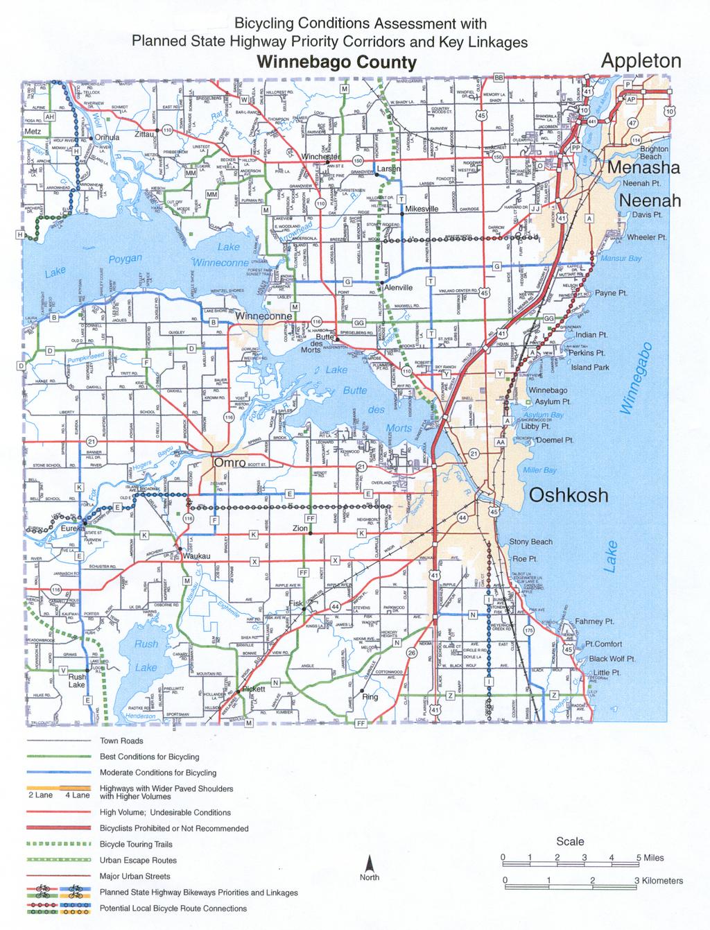
47
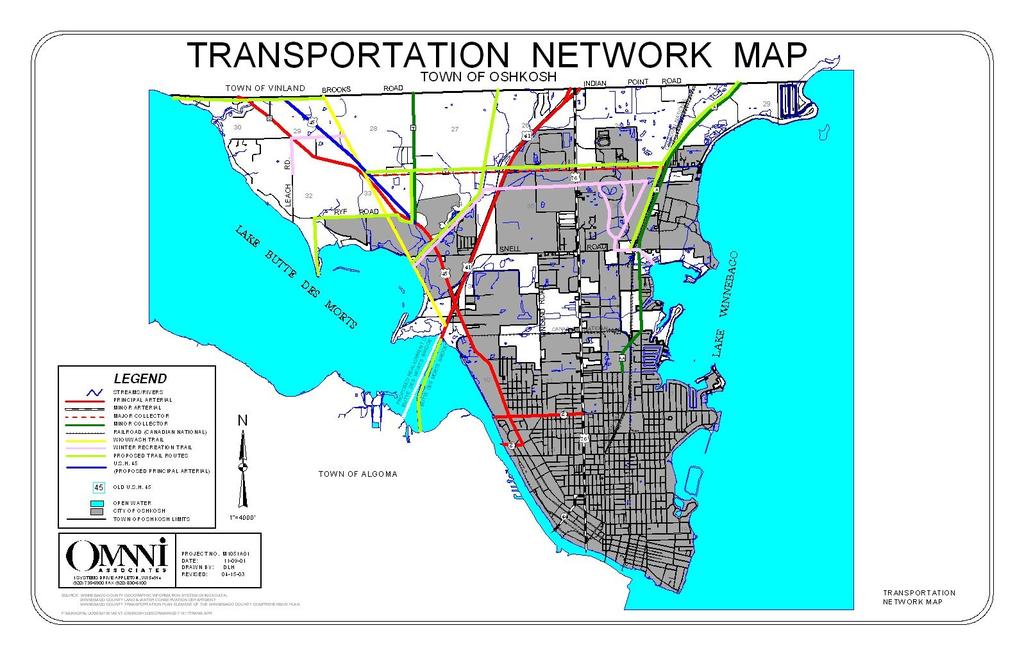
48
49 STREETS AND HIGHWAYS Streets and highways are classified according to their primary function, either to move vehicles or to serve adjacent land. Arterials accommodate the movement of vehicles, while local roads are designed to provide direct access to individual parcels of land. Collectors serve both local and through traffic by providing a connection between arterials and local roads. Facilities classified under the Federal Aids Secondary System (county trunks and state highways) qualify for federal aid for capital projects involving construction, reconstruction or repair. The Town of Oshkosh currently receives state transportation aids on a quarterly basis. The information provided below on the functional classification of different roadways in the Town of Oshkosh was provided by the Winnebago County Highway Department. Principal Arterials. USH 41 and USH 45 are classified as principal arterials in the Town of Oshkosh. They are designed to carry large volumes of traffic and provide efficient vehicular movement between cities in the region and beyond. The 2000 annual average daily traffic volume along USH 41 in the Town of Oshkosh ranged between 48,600 and 53,800 vehicles. The 2000 annual average daily traffic volumes along STH 110 (new USH 45) in the Town of Oshkosh was 12,600 vehicles (WisDOT, 2000). Minor Arterials. STH 76 is classified as a minor arterial in the Town of Oshkosh. Like USH 41 and USH 45, it is designed to carry large volumes of traffic. However, unlike USH 41 and USH 45, it directly connects the Town of Oshkosh with the City of Oshkosh and includes controlled traffic signs and signals to regulate traffic flow. Major Collectors. There are three major collectors in the Town of Oshkosh. CTH A, which runs parallel to Lake Winnebago to the City of Oshkosh, CTH T, north of USH 45, and CTH S (former portion of STH 110) is also classified as a major collector. Minor Collectors. CTH Y, between USH 45 and CTH A, is the only road classified as a minor collector in the town. It serves as the predominant east-west route through the Town of Oshkosh. Streets and highways are classified according to their primary function, either to move vehicles or to serve adjacent land. Principal Arterials serve interstate and interregional trips. These routes are in areas with populations greater than 50,000. Minor Arterials accommodate inter-regional and inter-area traffic movements, often in conjunction with principal arterials. Major Collectors provide service to moderate sized communities and other intraarea traffic generators. Many county trunk highways fall into this classification. Minor Collectors these roads collect traffic from local roads and provide links to all remaining portions of smaller communities and other higher function roads. Local Roads provide direct access to residential, commercial and industrial development. Local Roads. The remaining roads in the town are local. They provide access to residential, commercial and industrial uses within the Town of Oshkosh. All the roads described in this section are illustrated on the Transportation Network Map. Town of Oshkosh Comprehensive Plan Transportation Chapter

50 The town does not own any road maintenance equipment, nor does the town have any plans to acquire any. All town road construction, reconstruction and improvement projects are completed by Winnebago County through contract agreements with the Town of Oshkosh. Other maintenance (snow removal, etc.) is handled through contracts with Winnebago County and Radtke Contractors (Winneconne, WI). The town plans to utilize contract services indefinitely in the future because these arrangements provide quality, timely, cost effective services for the town. RAILROAD CORRIDORS Two railroad lines extend into portions of the Town of Oshkosh. One of the corridors extends from the City of Oshkosh, north, through the Town of Oshkosh onward to Menasha. This corridor runs somewhat parallel to Lake Winnebago and CTH A. It is owned and operated by Canadian National. Currently, this rail corridor is in active use as a shipping link between Wisconsin and the Upper Peninsula. There are no plans to abandon this railroad corridor. In fact, it is possible that if a high-speed railway is constructed between Green Bay and Chicago, this line may be used as a connection passenger route. This route crosses Snell Road, CTH Y and Sherman Road in the Town of Oshkosh. At each of these at-grade crossings a traffic signal is provided to prevent vehicle and train conflicts. The second railroad corridor in the town is actually a spur off the Canadian National line that travels west toward Lake Butte des Morts along the southern boundary of town sections 1, 2, and 3. In the Town of Oshkosh this line crosses STH 76, USH 45 and Vinland Road. At each of these at-grade crossings a traffic signal is provided to prevent vehicle and train conflicts. In 2001, the U.S. Surface Transportation Board approved a merger of Wisconsin Central and Canadian National Railroad companies. The $1.2 billion acquisition of Wisconsin Central by Canadian National is expected to improve rail freight service in Wisconsin, due to Canadian National s faster connections through the Chicago terminals. MASS TRANSIT Public bus service is not available within the Town of Oshkosh due to the low density of development within the town, thus limiting ridership. The Town of Oshkosh has no plans to establish its own transit service. Transit dependent residents of the town must rely on the assistance of friends or family, hire private transportation providers, or utilize the programs outlined in this section to meet their transportation needs. There is a park and ride lot in the Town of Oshkosh at the intersection of USH 45 and the WIOWASH trail. Qualified elderly and disabled residents may participate in the Dial A Ride program, which is coordinated through local private cab providers. Participants can call cab companies directly for reduced fee rides. In addition, subsidized taxi and van service is provided to senior residents (over age 60) and disabled residents, 24 hours a day, seven Town of Oshkosh Comprehensive Plan Transportation Chapter
51 days a week through a program sponsored by Winnebago County. This program is specifically targeted to rural county residents living in townships. The costs is $4.00 per one-way trip. Qualified participants are eligible for up to ten (10) one-way trips each month. There are no high-speed trains or other means of mass transit to serve residents north of Milwaukee. TRUCK TRANSPORTATION Dayton Freight Lines is located in the Town of Oshkosh at the intersection of USH 41 and USH 45. The terminal provides an excellent site to distribute freight and services to the Oshkosh Area and the Fox Cities and Green Bay areas to the north. The facility does not plan to expand in the near future. Primary truck routes through the Town of Oshkosh include USH 45, USH 41, CTH Y (between USH 45 and USH 41), and STH 76. WATER TRANSPORTATION Many residents and visitors to the Town of Oshkosh utilize waterways for recreational travel to neighboring communities located along the Pool Lakes (Butte des Morts, Winneconne and Poygan) and around Lake Winnebago. Therefore, continued access to the Lake Winnebago Pool System is an important local priority for the future. No additional facilities are planned at this time. The town believes that the available lake access is adequate to meet local demand for the next 20 years. For navigational purposes, the Winnebago County Parks Department contracts with Radtke Excavating Inc. to install buoys in the spring and remove them in the fall. In total, 77 buoys are provided in Lake Winnebago, Lake Butte des Morts, Lake Winneconne and the Wolf River Channel that lies in Lake Poygan. These buoys are important navigational aids that mark shallow areas or river channels and keep boaters from becoming stranded in shallow depths. The agreement between Radtke Excavating and the Winnebago County Parks Department n is expected to continue indefinitely into the future. AIRPORTS Wittman Regional Airport, located in the City of Oshkosh, is the nearest airport facility to the Town of Oshkosh. It is owned and operated by Winnebago County. The airport includes approximately 1,500 acres of land with over 87 hangars. There are 4 runways at the airport, a 24-hour manned fire station and a tower that is open from 6:00 am until 10:00 pm. Specifications of the runways are provided in Table 14. Town of Oshkosh Comprehensive Plan Transportation Chapter
52 TABLE 14 WITTMAN REGIONAL AIRPORT RUNWAY SPECIFICATIONS Runway Name Length Width Surface Material RWY ,002 feet 150 feet Grooved Concrete RWY ,178 feet 150 feet Grooved Asphalt RWY ,424 feet 75 feet Asphalt RWY ,000 feet 75 feet Asphalt SOURCE: AirNav.com for Wittman Regional Airport Wittman Regional Airport does not provide passenger service, but does offer a variety of other services. Basler Turbo Conversions converts DC-3 planes and operates the local fixed-base operation on the airport. Fox Valley Technical College, Aviation Services, and Valley Aviation operate flight schools at the airport. Wittman Regional Airport is also more widely known as the home for the Experimental Aircraft Association (EAA) headquarters, the annual AirVenture Convention (EAA Fly-In), and museum, which attracts close to one million visitors to the airport through out the year. Although provided, freight service based on the number of pounds handled at the airport is rather limited. Growth potential for airfreight at Wittman Airport is also limited given its proximity to the Outagamie County Regional Airport in the Fox Cities and Mitchell International Airport in Milwaukee. Classified as an Air Carrier/Cargo (AC/C) Airport designed to accommodate virtually all aircraft up to, and in some cases including, wide body jets and large military transports. According to the Wisconsin State Airport System Plan for 2020 (WisDOT), Wittman Regional Airport will retain its current classification for the next 20 years. It is one of nine (9) Wisconsin airports that have commercial air passenger service on a year round basis. The plan forecasts that Wittman Regional Airport will grow annually between 2000 and In 2000, the airport forecast was for 24,000 enplanements. In 2020, this figure was anticipated to increase to 44,000 enplanements. It should be understood that these projections differ greatly from current trends. Actual annual passenger enplanements have been steadily decreasing. In 1996, there were 8,608 enplanements. By 2000 this figure had dropped below 4,000 (WisDOT). In 2003, passenger flight service provided by Great Lakes Aviation ended at the airport. It should also be noted that Wittman Regional Airport provides the lowest number of enplanements of the nine airports that offer commercial air passenger services in Wisconsin. Summary of Existing Transportation Plans WISDOT STATE HIGHWAY PLAN 2020 Wisconsin's State Trunk Highway system, consisting of approximately 11,800 miles of roads, is aging and deteriorating at the same time traffic is increasing. In response to this critical issue, WisDOT, in partnership with its stakeholders, has developed the State Highway Plan 2020, a 21-year strategic plan which considers the highway system's Town of Oshkosh Comprehensive Plan Transportation Chapter
53 current condition, analyzes future uses, assesses financial constraints and outlines strategies to address Wisconsin's preservation, traffic movement, and safety needs. The plan is updated every six years to reflect changing transportation technologies, travel demand and economic conditions in Wisconsin. The plan classifies the USH 41 corridor between Oshkosh and Green Bay as a corridor that will experience extreme congestion if no capacity expansion is made. Furthermore, the plan indicates that the project would be considered a major capacity expansion subject to established environmental and legislative processes. Currently, the plan proposes to widen USH 41 from four to six lanes between the interchanges at USH 41/STH 26 and USH 41/Breezewood/Bell. In addition the following improvements are anticipated: STH 26 Interchange Minimal improvements. STH 44 Interchange Minimal improvements plus the replacement of the CTH K/West 20 th Avenue structure over USH 41 and provision of bike /pedestrian accommodations. 9 th Avenue Interchange Moderate improvements including a tight diamond design to pull the ramps closer to USH 41, expanding the 9 th Avenue structure to 6 lanes wide, replacement of the CTH E/Witzel Avenue structure over USH 41 and provision of pike/pedestrian accommodations. STH 21 Interchange Substantial improvements including: (1) a tight diamond, a shift of USH 41 to the west to minimize golf course impacts, Little Lake Butte des Morts impacts, and to avoid an existing utility line on the east side of the causeway, (3) a shift of USH 21 to the south, (4) no direct access points between traffic signals at Brooks Lane and Oshkosh Avenue, and (5) construction of a bike/pedestrian overpass between USH 21 and Lake Butte des Morts to connect with a proposed trail across the lake. Lake Butte des Morts Crossing Widen existing causeway to the west, provide three through lanes an 1 auxiliary lane in each direction, and preserve northbound lanes and bridges for future bike/pedestrian facility. USH 45 Substantial improvements including: (1) a free flow route for northbound USH 41 to northbound USH 45, southbound free flow route from southbound USH 45 to southbound USH 41, (3) shift of USH 41 to the west (to avoid electric substation), (4) new structures to accommodate the WIOUWASH trail crossing, (5) new structure across USH 41 at Fountain Avenue, and (6) proposed improvements to match planned construction on USH 45. USH 45 Interchange Minimal improvements including widening of the USH 45 structure over USH 41 to three lanes, and reconstruction of USH 45 between frontage roads to accommodate the new lane configurations. Breezewood/Bell Interchange - Moderate improvements including a tight diamond interchange and an increased number of turn lanes to handle traffic volumes in the 2025 design year. If all proceeds smoothly, it is anticipated that construction will begin in Town of Oshkosh Comprehensive Plan Transportation Chapter
54 Through 2020, USH 45 is designated by WisDOT as an important corridor route that will continue to connect key communities and regional economic centers to primary corridors like STH 29, USH 41, and USH 51/I-39. WISDOT HIGHWAY IMPROVEMENT PROGRAM In addition to the major projects WisDOT has outlined in its 2020 Highway Plan, WisDOT s Highway Improvement Program indicates that the intersection of In 2002, USH 45 and CTH Y was be improved to construct a 0.1 mile median barrier at the intersection to improve safety. No additional projects are identified on the WisDOT Plan in the Town of Oshkosh. WINNEBAGO COUNTY In 2000, Winnebago County hired a private consultant to develop the Transportation Plan Element of the Winnebago County Comprehensive Plan. This element was completed in January 2002 and is currently being reviewed by communities throughout Winnebago County. The document indicates that the overall county goal is to achieve a safe, efficient, and environmentally sound transportation system that provides personal mobility for all segments of the population and supports the economy of the county. To achieve this goal, the plan outlines a series of objectives and supporting policies. The majority of the plan is dedicated to an inventory of existing transportation facilities and services in the county. This plan was reviewed in detail during the development of the Town of Oshkosh Comprehensive Plan and elements of the inventory have been included in this chapter. Most of the policies outlined in the Transportation Plan Element of the Winnebago County Comprehensive Plan will be implemented directly by the county. Moreover, since the Town of Oshkosh is under county zoning, several of the recommendations will be carried out through changes to the county zoning ordinance. The Transportation Plan Element of the Winnebago County Comprehensive Plan includes several policies that directly impact the Town of Oshkosh: Local units of government should adopt regulations concerning the use of highways, including those that prevent the deterioration of structures and the highway surface. Access control standards should be adopted by County and Town governments to provide the level of access control appropriate to the function of the highway. Annually, local government should review accident-producing facility deficiencies, if any, and assign priorities for correction County, city, and town street design standards should be adequate for the legal speeds, sizes and weights of vehicles. Local comprehensive plans should prevent the location of roadways through environmentally sensitive lands. Town of Oshkosh Comprehensive Plan Transportation Chapter
55 Local transportation planning should protect historic or visually pleasing buildings and scenic, historic, scientific and cultural sites when constructing new or improving existing transportation facilities. Local transportation plans should minimize air pollution through efficient traffic control measures and encourage transit, bicycle and pedestrian travel. Local units of government, through adopted ordinances, should design transportation facilities to be aesthetically pleasing and sensitive to the natural landscape minimizing unsightly views such as junkyards, billboards, and strip commercial development in more rural areas. Transportation planning by local units of government should include using native vegetation along roadsides in areas of the County where it is appropriate to protect wildlife, reduce the use of herbicides, and cut maintenance costs. Future land use plans should plan for bicycle and pedestrian-related activities. Each development must consider the integration of bicycle and pedestrian modes of transportation and policies and ordinances should be adopted to require this as needed. The town is amenable to these policies and will work under the guise of this plan to ensure that these activities are carried out to the fullest extent possible in the Town of Oshkosh. Specific actions of the town are outlined in the Goals and Objectives portion of this chapter. WITTMAN REGIONAL AIRPORT MASTER PLAN The Wittman Regional Airport has an Airport Master Plan that was adopted by Winnebago County in Given changes in federal subsidies, an overall decreased use due to easy access to the nearby Outagamie County Regional Airport and Mitchell International Airport, the future of Wittman Regional Airport is uncertain. Much of the information included in the plan is outdated. According to the Airport Manager, the Airport Master Plan will be updated in MIDWEST REGIONAL RAIL SYSTEMS Since 1996, the Midwest Regional Rail Initiative (MWRRI) advanced from a series of service concepts, including increased operating speeds, train frequencies, system connectivity and high service reliability, into a well-defined vision to create a 21 st century regional passenger rail system. This vision has been transformed into a transportation plan known at the Midwest Regional Rail Systems (MWRRS). The primary purpose of the MWRRS is to meet future regional travel needs through significant improvements to the level and quality of regional passenger rail service. The major MWRRS elements will improve Midwest travel. The major plan elements include: Town of Oshkosh Comprehensive Plan Transportation Chapter

 and infrastructure improvements (i.")
56 Use of 3,000 miles of existing rail rights-ofway to connect rural, small urban and major metropolitan areas throughout Minnesota, Iowa, Missouri, Illinois, Indiana, Ohio, Michigan and Wisconsin. Operation of hub-and-spoke passenger rail system through Chicago to locations throughout the Midwest. Introduction of modern train equipment operating at speeds up to 110 mph Provision of multi-modal connections to improve system access Improvements in reliability and on-time performance The cost to provide the improvements needed to facilitate a Chicago-Milwaukee- Minneapolis/Green Bay Route would be $978 million, including rolling stock (i.e. passenger cars) and infrastructure improvements (i.e. track improvements). Under the plan, the City of Oshkosh would be a connection point for feeder busses serving Rhinelander and Wausau to transfer to a train to connect in Milwaukee to a high speed rail line. The current schedule provided in the MWRRS plan calls for the entire project to be completely on-line by The first phase of the MWRRS plan in Wisconsin calls for 110 mph rail service between Madison and Milwaukee, and continuing to Chicago by EAST CENTRAL WISCONSIN REGIONAL PLANNING COMMISSION The East Central Wisconsin Regional Planning Commission (ECWRPC) has adopted a transportation goal and supporting objectives, which it uses to evaluate transportation plans developed in the area. As part of the comprehensive planning process, these goals were reviewed to ensure consistency with the Town of Oshkosh Comprehensive Plan. Many of the ECWRPC goals relate to services and facilities that are not available in the Town of Oshkosh (i.e. airports, etc.). The overall goal for the regional transportation program is to provide a safe, efficient and environmentally sound transportation system that provides personal mobility for all segments of the population and supports the economy of the region. This statement is consistent with the vision and goals set forth by the Town of Oshkosh. To support this goal, the ECWRPC has outlined a series of objectives pertaining to: integrated planning, maximum street effectiveness, an efficient street and highway system, safety, minimum environmental disruption, compatibility with land use patterns, conservation of energy, and multi-modal interaction. Each of these objectives is addressed to the fullest extent practical in this chapter of the Town of Oshkosh Comprehensive Plan. Town of Oshkosh Comprehensive Plan Transportation Chapter
57 CITY OF OSHKOSH COMPREHENSIVE PLAN, 1993 The City of Oshkosh Comprehensive Plan is the primary planning document for the City. This plan is not a Smart Growth Comprehensive Plan and therefore, does not address the nine required elements as outlined in 1999 Wisconsin Act 9. The City of Oshkosh is just beginning to develop a Smart Growth Comprehensive Plan. This plan is not expected to be completed until after the Town of Oshkosh Comprehensive Plan is adopted. In developing the Town of Oshkosh Comprehensive Plan, efforts were made to review the recommendations included in the City s plan. In the City s plan, transportation improvements are closely tied to land use patterns and economic development objectives. Therefore, these issues are addressed in other chapters of this plan. COMPARISON TO STATE AND REGIONAL PLANS Generally, there is a division in jurisdiction related to transportation facilities and services (i.e. County Roads, State Highways, and Town Roads). The transportation network in the Town of Oshkosh requires coordination between these jurisdictions to work efficiently. Therefore, in developing this plan, the town invested a significant amount of time researching and coordinating with county, regional and state transportation plans, policies and programs. As a result, the town s transportation goals, policies, objectives and programs compliment state and regional transportation goals, objectives, policies and programs by providing local transportation facilities and services that connect to county/regional and state facilities. Specific areas of concern related to existing state and county transportation plans are discussed in the next section. Transportation Issues and Concerns The primary transportation issue facing the Town of Oshkosh is the scheduled expansion of USH 41 and realignment of USH 45 by WisDOT. COMMUNITY SURVEY RESULTS 84% of respondents felt controlling traffic congestion in the Town of Oshkosh should be a very important or important priority. USH 41 1 USH 41 is a multi-lane backbone roadway under WisDOT s Corridors 2020 Plan, designed to enhance economic development and meet future mobility needs. USH 41 carries substantial traffic, including trucks and recreational vehicles. In Winnebago County, USH 41 is also a major regional and local facility serving economic development in the Oshkosh and Neenah urbanized areas and surrounding towns. Current traffic ranges from 41,000 vehicles per day to 68,700 per day. Additional improvements are needed to address increasing traffic, emerging safety and traffic flow problems. 1 Much of the information used to create this subsection was compiled from the Transportation Plan Element of the Winnebago County Comprehensive Plan, January 9, Town of Oshkosh Comprehensive Plan Transportation Chapter
58 In response to this issue USH 41, from one-half mile south of the STH 26 intersection in the Town of Nekimi to one-half mile north of the Breezewood Lane/Bell Street interchange in the City of Neenah, is currently being evaluated to develop a concept plan for upgrading USH 41. Improvements to existing interchanges may include widening/extending the freeway on and off ramps, widening cross roads and relocating portions of frontage roads. The study will also evaluate the need for additional driving and auxiliary lanes on USH 41, including the Lake Butte des Morts bridge crossing. The two-year study will conclude in the spring of The recommendations from the study will be presented to WisDOT for budget consideration. Those involved are hopeful that the project will receive budget approval for construction in Representatives from the Town of Oshkosh continue to participate in these discussions, particularly with respect to intersection locations and alignments. The upgraded USH 41 corridor allow for much needed additional capacity to serve existing and projected traffic volumes. It will make the roadway safer and provide efficient transportation for all types of traffic. When completed, the USH 41 corridor will reduce travel time for commuters and commercial trucks, while also making travel safer by removing the cross traffic and access points. The development will bring many direct and indirect economic benefits to the Town of Oshkosh, including business development near the highway. USH 45 2 The planned conversion of STH 110 to a limited access four-lane roadway with a gradeseparated interchange at STH 116 will substantially improve access from the City of Oshkosh and USH 41 to the Village of Winneconne and surrounding areas. The USH 45 designation will be moved to the present STH 110 corridor and rebuilt to freeway status from CTH T to CTH G in 2002 and CTH T will be an at-grade intersection. The new USH 45 will be a 4-lane state road with no access until STH 116, which will have a diamond-shaped freeway interchange. Another access will not be allowed until CTH G, which will have an at-grade intersection. This 7.8-mile widening project is estimated to cost $39 million dollars. The remaining portion of STH 110, starting at the realigned intersection of CTH T/Ryf Road will become CTH S. The completion of the USH 45 project will add 32 State Road miles for Winnebago County to maintain. This is due to an all-new alignment of the State Road from CTH T to CTH G, leaving the present STH 110 corridor as a separate roadway that must be maintained. Frontage roads along the new USH 45 (in the Town of Vinland) will add another 14 roadway miles for the county to maintain, along with interchange lanes at State Road Much of the information contained in this subsection was based on the Transportation Plan Element of the Winnebago County Comprehensive Plan, January 9, Town of Oshkosh Comprehensive Plan Transportation Chapter
59 Current WisDOT plans for STH 76 (former USH 45) show a four-lane divided from the City of Oshkosh to CTH G. The remaining portion of this roadway is to remain as a twolane road extending north to USH 10. These changes will impact the Town of Oshkosh in several ways. Specifically, the limited access status of USH 45, will restrict development potential along this corridor and may create a divide between residents living between the lake an the highway and others living on the northeast side of the bridge. In 2001, ECWRPC published a summary report of the U.S. Highway 45 Relocation and Corridor Study. This report included some additional recommendations, including that a freeway type interchange be constructed at CTH T and Ryf Road as soon as possible. At this time, there are no plans to take action on this recommendation. However, if it is pursued, it has the potential to impact the Town of Oshkosh by bringing more residential and commercial development to the town near this intersection. If constructed, this plan should be reviewed immediately to ensure that the land uses illustrated on the Future Land Use Maps are still practical and desirable to the town. Future development near this intersection should be in harmony with the visions presented in the plan. CTH A The Transportation Plan Element of the Winnebago County Comprehensive Plan recommends that the CTH A corridor continue to be maintained as a 2-lane roadway over the next 20 years. This recommendation was encouraged by the Town of Oshkosh, Town of Vinland and Town of Neenah as a means of maintaining the rural town character of the roadway. Today, there is a great deal of traffic along CTH A. Currently, the Winnebago County Highway Department is working to acquire additional right of way along CTH A. The county plans to resurface the roadway, somewhat straighten the curve south of Indian Point Road and add a bicycle lane. The town is adamant that CTH A should continue to exist as a two-lane road. The town fears that if the road were expanded to four-lanes, this improvement would create additional pressure for more development along CTH A. Additionally, the Town of Oshkosh supports the WisDOT bicycle conditions assessment that indicates that CTH A could support a bicycle path. The Town of Oshkosh believes that if CTH A is expanded to four-lanes, additional traffic and development would preclude the establishment of a trail along the roadway. Furthermore, the Town of Oshkosh, Town of Vinland and Town of Neenah believe an additional exit should be developed along the USH 41 corridor at CTH G as part of the USH 41 expansion project. The towns believe this exit will encourage people who currently travel along CTH A to utilize USH 41 instead, thereby helping to maximize the capacity of USH 41 and reduce traffic on CTH A. PASER RATING SYSTEM REPORT In the fall of 2001, the Town of Oshkosh had the Winnebago County Highway Department complete its Pavement Surface Evaluation and Ratings (PASER) for all town Town of Oshkosh Comprehensive Plan Transportation Chapter
60 roads in accordance with WisDOT requirements. PASER is a visual inspection system to develop a condition rating for community roads. PASER is an important tool for smaller government unit planning because it gives a picture of road conditions on all roads and can identify candidates for maintenance and rehabilitation. Surface defects, cracking and potholes are all examined during a typical PASER evaluation. Roads are rated 1 10 based on their condition. Rating 9 & 10 no maintenance required Rating 7 & 8 routine maintenance, cracksealing and minor patching Rating 5 & 6 preservative treatments (sealcoating) Rating 3 & 4 structural improvement and leveling (overlay or recycling) Rating 1 & 2 reconstruction Table 16 provides the total number of miles of roadway in the town by each PASER ranking. In total there are miles of roads in the Town of Oshkosh that were evaluated. The majority of town roads ranked as 5 or 6 in the PASER results. TABLE 15 MILES OF ROADWAY BY PASER RANKINGS PASER RANK TOTAL MILES OF ROAD Source: 2001 PASER Rating System Report, Town of Oshkosh It is important to understand that the town roads were rated in segments. As a result, a portion of a particular road may rank as 9, whereas a different segment may only rank as 6. These fluctuations can greatly impact the overall need for construction improvements. In order to gain a general understanding of the condition of local roads in the Town of Oshkosh, the table below identifies the average rank for each town road. For example, if a town road were ranked in three segments of varying length as 2, 4, and 6, respectively, then the overall rating for the road in the table below would be 4. TABLE 16 AVERAGE PASER RESULT BY ROADWAY ROAD NAME AVERAGE RATING Luebke Road 6 Shangrila Point 8 Sunset Point Lane 5 Bellair Lane 5 Town of Oshkosh Comprehensive Plan Transportation Chapter
61 Vinland Street Butler Avenue 5 Sherman Road 4.6 Shorewood Drive Island View Drive 8 Hickory Lane Channel View Drive 8 Brooks Road 5.5 Nickels Drive 5 Plummers Point Road 5 Leach Road 6 West Wind Road Nicolet Avenue 8 Sunnyview Road 8 Edgewood Lane 7 Zion Street 7 Clover Street 2 Skyranch Avenue 2 Harbor Bay Road 3 Anderson Street 7 Cozy Lane 2 Norton Avenue 6 Nielsen Drive 6 Pickett Avenue 5 Indian Point Road 6 I-AH-MAY-TAH Road 8 British Lane 6 Ivy Lane 5 Clover Lane 2 Glendale Ave 6 Primrose Lane 7 Courtland Avenue 7 Western Drive 6 Tumble Brook Drive 5 Juniper Lane 6 Tamarack Trail 5 Violet Lane 5 Bittersweet Lane 6 Richards Avenue 6 Kristine Street 6 Roberts Ave 6 Green Valley Road Snell Road Marine Drive 4.5 Nolte Avenue 5 Andrew Street 7 Ulman Street 5 Schneider Avenue 4 Killdeer Lane 8 Old Oak Road 4 Ryf Road 5 Chesapeake Court 8 Indian Bend Road 9 Source: 2001 PASER Rating System Report, Town of Oshkosh Town of Oshkosh Comprehensive Plan Transportation Chapter
62 According to the PASER manual, it is recommended that communities strive to attain a rating of 7 for all roads. Likewise, the Town of Oshkosh places a strong priority on maintaining local roads. To achieve this goal, members of the Town Board, along with a representative of the Winnebago County Highway Department, conduct an annual review of all town roads. Given that the town has relatively few miles of roadway, this review is usually completed in a single day. The result of the process is an accurate assessment of conditions and an identification of improvement priorities. This system has worked well for the town for many years. The fact that the county highway department representative and the Town Board members have much experience with this practice is a strong asset to the town in this process. If, in the future, the town decides that additional tools are necessary to achieve the same level of assessment of its roads to determine the best course of action with respect to annual road improvements and to maximize its available funds, it is recommended that the town further analyze its PASER results using PASERWARE. This software program is designed to help communities consider different scenarios for extending their money with respect to road maintenance and improvements. Using PASERWARE, a community can determine what sequence of improvements is recommended to meet a certain goal (i.e. get all roads to a 7 rating). PASERWARE also will provide cost estimates for maintenance and construction projects. If desired, the town can provide the PASERWARE with the total funds available for roads in a given year, and the program will recommend ways to best spend the money to obtain the greatest return. At some point in the future, the town may also consider developing a capital improvements program and budget to effectively plan for road improvements in relation to other town spending needs. A capital improvements program and budget may use the recommendations of PASERWARE, or the recommendations determined by the Town Board and Winnebago County Highway Department Representative, as part of the annual road assessment to plan for road improvements in a 5 6 year cycle. This capital improvements program may also be used to plan for improvements to town facilities (i.e. town hall, garage, etc.), purchase computer equipment, or replace fire equipment. LAND USE IMPLICATIONS Transportation improvements to USH 41 and USH 45 have the potential to impact sensitive lands in the Town of Oshkosh. Specifically, improvements to increase capacity of these highways may result in the loss of additional agricultural land and habitat fragmentation. Water features may also be impacted by highway improvements. For example, the filling of wetland and construction related erosion and runoff are a concern. Moreover, post-construction storm water runoff resulting from impervious highway surfaces is a threat to Lake Butte des Morts and Lake Winnebago. To combat these trends, WisDOT has created a wetlands bank. These banked wetlands are located outside of the Town of Oshkosh (with the exception of the banked wetland north of CTH Y) and are used to offset wetlands that are lost due to highway projects. To spite good intentions, there is much debate about the value of a man-made banked wetland versus a natural wetland area. Moreover, there is local debate over the loss or impact to any local Town of Oshkosh Comprehensive Plan Transportation Chapter
63 wetland. WisDOT understands that the finalized plans for USH 41 must address these concerns and consider local mitigation techniques in order to gain local support. GROWTH AND DEVELOPMENT The upgraded USH 41 corridor will create development opportunities and pressure. The town would like to capitalize on this opportunity for increased development, but not at the expense of the town s rural character. Any development at or near interchanges must be well-planned and adequately served by utilities and community facilities. To support the safe and efficient movement of traffic, the town also supports the utilization of frontage roads to ensure that the development will not interfere with traffic flow along USH 41. Travel time will be decreased between the Town of Oshkosh, the Fox Cities, Green Bay and Fond du Lac. Already, some residents of the Town of Oshkosh commute as far as Green Bay and even Milwaukee to work each day. These residents enjoy the rural atmosphere provided in the town and the economic activities available elsewhere. Decreased commuting times and reduced congestion may bring additional residents to the Town of Oshkosh. This may create additional demand for housing, roads, utilities, schools and other community facilities. If carefully planned, additional growth will not have a negative impact the town s rural character. TRANSPORTATION BUDGETING Another transportation issue in the Town of Oshkosh, beyond the scope of the highway improvements, is the road maintenance and improvements costs. These types of municipal activities are a major expense and can consume a large share of the town budget. This plan recommends long-term strategies, including a capital improvements program and budget, to help the town to effectively budget for these costs over time. A capital improvements program in the Town of Oshkosh would serve as the town s present and near-future financial plan to match future capital improvement costs, such as roads, to anticipated revenues. If the town decides to develop a CIP/B, the Town of Oshkosh Planning Commission should be given the authority to develop and review the CIP/B, thereby linking planning to the annual budgetary process. CIP/B are usually prepared for five or six years into the future and updated annually. The CIP/B process would first identify and then prioritize capital expenditures. An estimated cost and means of financing each capital expenditure would be included as part of the process. The desired expenditures would be compared to the budget to determine annual spending priorities. The process helps to ensure that improvements are made in a logical order and do not surprise town officials or taxpayers. Town of Oshkosh Comprehensive Plan Transportation Chapter
64 Coordination with Other Required Plan Elements ISSUES AND OPPORTUNITIES How do transportation facilities affect the aesthetics of the Town of Oshkosh? Aesthetics refer to the appearance and character of an area. Generally speaking, a transportation project should reflect the aesthetics of a community. For the Town of Oshkosh the aesthetic character varies significantly from one area to the next. The lakefront subdivisions in the sanitary districts have a much different character than the areas along USH 45 and USH 41. The Issues and Opportunities Element establishes the framework for planning the overall future vision the ideal from which this plan has been developed. That vision will impact the way the town considers and approves changes to the transportation network. It will also guide their participation in activities sponsored by WisDOT. To realize the vision, and support the transportation vision presented in this chapter, the town will seek to preserve scenic areas using easements, designing road projects to fit into the natural landscape and landscaping areas where necessary to retain the rural character after road construction is completed. AGRICULTURAL, NATURAL AND CULTURAL RESOURCES How will changes to the transportation system impact the preservation /protection of environmental resources such as water quality? Given that the town only has jurisdiction over town roads, the answer to this question will likely be dictated by the actions of Winnebago County and WisDOT. Both agencies have policies in place designed to protect the natural environment. It will be incumbent upon town residents and leaders to continue to participate in public hearings and other opportunities for input, to ensure that local interests are realized in these projects as they relate to the natural environment. The town will seek to ensure that the location of town roadways through environmentally sensitive areas is minimized. UTILITIES AND COMMUNITY FACILITIES How will the Town of Oshkosh ensure that the decisions made for the transportation system preserve the existing facilities and potentially reduce the need for expansion or realignment? The answer to this question in realized in the Land Use Element whereby the location of future development, and associated transportation improvements, is correlated to the location of adequate utilities and community facilities. ECONOMIC DEVELOPMENT Providing a quality transportation system is important to the success of any business. Just as businesses need good access, employees also want to be able to efficiently access their places of employment. Lack of access to employment opportunities my affect individual decisions to seek employment or live in a community. In the Town of Oshkosh these issues were carefully considered, particularly with respect to the location Town of Oshkosh Comprehensive Plan Transportation Chapter
65 of new commercial and industrial development. The local solutions to these issues are reflected on the Future Land Use Maps. LAND USE While transportation improvements generally respond to changes in land use, they also have the potential to directly and indirectly affect land development either by inducing new development or altering the pattern of existing development. In the Town of Oshkosh, it is widely anticipated that by adding capacity to the highways to reduce congestion, business development along these routes will become more desirable. New development may occur along frontage roads and at intersections. What steps will be taken to ensure that transportation decisions and land use decisions are compatible? Although transportation is not the only influence on land use, it is important to be aware that decisions regarding the transportation system may impact land use both directly and indirectly. Direct impacts that are directly caused by the construction of a new transportation facility, changes to an existing facility, and/or decision to change traffic patterns along a facility. These may result in positive or negative impacts. For example, expansion of the USH 41 corridor will improve traffic flow, minimize the potential for traffic back-ups at the Butte des Morts Bridge and improve traffic safety. However, the construction will result in the loss of some wetlands and developable land along the existing corridor. Likewise, by expanding the USH 41 corridor, adjacent lands are likely to experience a change in value as they become more attractive for development. Efforts were made to plan accordingly for land uses along USH 45 and USH 41 and are reflected on the Future Land Use Maps. IMPLEMENTATION Through the development of a capital improvements plan and budget the associated costs of the transportation element can be addressed. The town s capital improvements plan and budget will seek to not only plan for town expenditures but also to locate grant and low interest loan opportunities that may exist to fund needed improvements. Goals and Objectives It is the goal of the Town of Oshkosh that residents will enjoy safe streets and highways with minimal traffic congestion and safe bike/pedestrian routes and trails. Because the Town of Oshkosh has a minimal amount of control over county roads and state highways, the goals in this section are related to actions that the town can control. The Town of Oshkosh will work, in accordance with the Intergovernmental Cooperation Element of the Wisconsin Smart Growth Law, with Winnebago County and WisDOT to ensure that adequate community transportation facilities are available to serve the area. Town of Oshkosh Comprehensive Plan Transportation Chapter
66 GOALS 1. Seek to preserve town rural character and avoid destruction of environmentally sensitive areas. 2. To maintain and improve town roads in a timely and well planned manner. 3. Ensure that the reconstructed USH 41 and realigned STH 110/USH 45 corridors meet the needs of the Town. 4. Seek to expand opportunities for alternative transportation in the Town of Oshkosh. OBJECTIVES 1. Develop a Capital Improvements Program and Budget (CIP/B) to coordinate and plan for annual roadway improvements and maintenance as well as other capital improvements. 2. Provide the WisDOT with copies of all planning materials prepared by the town. 3. Seek to become an active partner in the expansion of USH 41 by: A. Working with the WisDOT at any opportunity presented. B. Educating residents about the planned expansion. C. Reviewing the 2020 Future Land Use Map in 2010 to ensure that the planned land use pattern within 1 mile of the improved USH 41 corridor is still desirable based on impact of the highway improvements and demand for new development. If changes are desired, amend the plan following all requirements outlined in 1999 Wisconsin Act Continue to monitor discussions between the ECWRPC and WisDOT related to a potential freeway type interchange at CTH T and Ryf Road. Participate at any opportunity presented to ensure town interests are represented in the discussions. If approved, review the land use plan in this area to ensure that the planned land use pattern is still practical. If necessary, amend the plan following the requirements outlined in 1999 WI Act Coordinate with Winnebago County to ensure that proposed trail routes outlined in the Winnebago County Transportation Element are completed in the Town of Oshkosh in a coordinated fashion with road improvement schedules. 6. As stipulated in the Transportation Plan Element of the Winnebago County Comprehensive Plan, the Town of Oshkosh will address the following activities. A. Coordinate with Winnebago County to develop town road standards which seek to maintain the quality of road surface and structures. B. Develop a local policy to support access control standards which limit ingress and egress from county roads in order to protect the function of these corridors. C. Annually review accident reports for the town to identify priorities for transportation improvements to protect public safety. D. Review town street standards, particularly with respect to development in conservation and cluster subdivisions, to ensure that the design standards are adequate for legal speeds, sizes and weights of vehicles. E. Using the Future Land Use Maps as a guide, seek to prevent the location of roadways through environmentally sensitive lands in the Town of Oshkosh. F. Seek to protect scenic areas when constructing new or improving existing transportation facilities. G. Encourage the development of bicycle and pedestrian trails, in accordance with WisDOT recommendations and the Transportation Plan Element of the Winnebago County Comprehensive Plan. H. Review standards for town road development to ensure that roads will be sensitive to the natural landscape by minimizing unsightly views such as junkyards, billboards, and strip commercial development in more rural areas and the use of native vegetation along roadsides is encouraged to protect wildlife, reduce the use of herbicides, and cut maintenance costs. 7. Using the Transportation and Existing Land Use Maps in this Plan, adopt and maintain an official map at the Town Hall. [NOTE: This action may only be taken if existing legislation is changed to allow towns under county zoning to take this action.] Town of Oshkosh Comprehensive Plan Transportation Chapter
67 6.0 UTILITIES AND COMMUNITY FACILITIES Utilities and Community Facilities Vision The Town of Oshkosh coordinates with Winnebago County and the City of Oshkosh to ensure that residents of the Town of Oshkosh have easy access to a full-range of services, including: medical care, retail, educational facilities and entertainment choices. The town strives to ensure that property taxes are minimized without jeopardizing public health and safety by constantly striving to improve efficiencies in service delivery and pursuing shared services with neighboring communities as a means to reduce costs. The provision of community services and infrastructure are closely coordinated and do not create unreasonable financial burden for residents. Portions of the town are still served by municipal sewer, while all residents rely on private well water. Existing Facilities Inventory Location, Use, Capacity Understanding the location, use and capacity of utilities and community facilities is an important consideration when planning for the future. This information, coupled with the demographic trends and projections, provides a realistic picture of service supply and demand. The community facilities and utilities discussed in this chapter were carefully considered in the development of the Future Land Use Maps. What follows is a description of existing utilities and community facilities within the Town of Oshkosh. Many of the services available to town residents are provided by neighboring communities or Winnebago County. These arrangements have helped to control town costs over the years. Therefore, included in this chapter is information about some of the utilities and community facilities located in and provided by the City of Oshkosh and Winnebago County. WASTEWATER COLLECTION AND TREATMENT 1 There are five (5) sanitary districts in the Town of Oshkosh Island View, Sunset Point, Edgewood-Shangri La, Butte des Morts Consolidated and the Oshkosh Sanitary District. The City of Oshkosh Publicly Owned Treatment Works (POTW) provides wastewater treatment for three of these sanitary districts. Annexation of these areas to the city to 1 Information about the Butte Des Morts Sewer Service Area Plan is from the Butte Des Morts Sewer Service Area Plan, prepared by the East Central Wisconsin Regional Planning Commission in cooperation with the State of Wisconsin Department of Natural Resources, Town of Oshkosh Comprehensive Plan - UCF Chapter
68 obtain this service was not required due to consensual bargaining with the City of Oshkosh. The Oshkosh POTW was completed in This treatment plant serves the City of Oshkosh, Town of Algoma Sanitary District No. 1, Black Wolf Sanitary District No. 1, and the Town of Oshkosh sanitary districts. The plant consistently meets permit limits for all parameters. Based on its design use, the existing facility should be adequate through the year At that time, the capacity of the plant should be evaluated and possibly expanded to accommodate additional area growth. The Town of Oshkosh should participate in any decisions made regarding plant expansion. Rapid growth in any of the town s sanitary districts, as described below, is not feasible given that new housing development in any sanitary district is limited to 5 lots (residences) per district per year as is required by the City of Oshkosh treatment plant serving these districts. The Island View Sanitary District, located along the west shore of Lake Winnebago, is approximately 300 acres in size and contains 185 acres of residential development. The district was formed in 1995 to address individual septic system problems. The estimated 1997 population of the Island View Sanitary District was 667 with 250 residential units. This sewage system includes three (3) lift stations that permit the flow of wastewater to reach to the Oshkosh POTW. It should be understood that 20 25% of the residents served by the Island View Sanitary District are located in the City of Oshkosh, and another approximately 25 residences within the District are located in the Town of Vinland. It is possible for the boundaries of this district to be expanded in the next 10 years because the sanitary district has an agreement with the City of Oshkosh to serve west to the Sherman Road and Indian Point areas. However, District policies require that the cost of providing service to new areas be borne by those parties requesting such service. Because of the cost and the limit on the number of connections available to the District, it is unlikely that there would be any substantial expansion beyond the current boundaries. The Sunset Point Sanitary District is approximately 150 acres in size and contains 40 acres of residential and five acres of commercial development. The Sunset Point Sanitary District was formed in 1993 and is located on the north shore of Lake Butte des Morts just west of the USH 41 Butte des Morts Bridge. In 1997 this district included 100 permanent and seasonal residential units with an estimated population of 267. The district has one (1) lift station and contributes 0.75 million gallons per month to the Oshkosh POTW (ECWRPC Oshkosh Sewer Service Area Plan, 1997). There are 18 lots in this sanitary district that are currently zoned for additional homes. Property owners in the area are trying to get these parcels rezoned for garage lots, rather than additional housing units. There are no plans to expand the boundaries of, or connections within, this district. The Edgewood Shangri La Sanitary District was established in March of The district currently serves 66 residences. The district can accommodate up to 70 lateral connections. There are four (4) vacant properties within the current district boundaries that could be connected in the future. The Edgewood Shangri La Sanitary District Town of Oshkosh Comprehensive Plan - UCF Chapter
69 contributes 207,000 gallons per month to the Oshkosh POTW (2001 average). The district has a contract with the City of Oshkosh that prohibits additional expansion of the district at this time. At most, if negotiations with the City of Oshkosh are successful, the district secretary believes that up to 10 new connections could be made within the district in the next 20 years. The Butte des Morts Planning Area and Sewer Service Area are located between Lake Butte des Morts and STH 110, near its intersection with STH 116. The planning area lies within portions of the Town of Winneconne, Town of Oshkosh and Town of Vinland. The Sanitary District within the planning area encompasses approximately 777 acres, of which approximately half is developed. In addition, the small recreational unincorporated community of Butte des Morts is completely encompassed by the Butte des Morts Sanitary District. This area is the core of dense development within the district, with an estimated 2001 population of 939 persons. The community of Butte des Morts is located in the Town of Winneconne. Much of the area of the Butte des Morts Sewer Service Area in the Town of Oshkosh is considered wetland by the DNR. Residential development along Lake Butte des Morts, in the far northwest corner of the township, is in the sanitary district. A very limited area of undeveloped land exists between STH 110, the Town of Vinland, and the existing shoreland development within the Butte Des Morts Sewer Service Area in the Town of Oshkosh. The boundaries of the sewer service area are outlined on the Utilities and Community Facilities Map at the end of this Chapter. Recently, development pressure has increased in the sanitary district due to the communities close proximity to the cities of Oshkosh and Neenah. A majority of residents in the Butte des Morts Sewer Service Area Planning Area are connected to the Sanitary District s sewer system. Residents that are not connected rely on individual onsite wastewater treatment systems (i.e. holding tanks, conventional septic, and mound systems). The Butte des Morts Sanitary District s wastewater treatment facility, constructed in 1991, is located in the north-central portion of the Planning Area, along Spielgelberg Road. The treatment plant is a package type facility which discharges treated effluent directly into Lake Butte des Morts, and utilizes a series of lagoons for sludge storage. The sludge is eventually landspread on agricultural lands. The district s existing wastewater collection system consists mainly of eight-inch gravity sewers that culminate in a 10-inch gravity sewer. This, in turn, discharges to a lift station that pumps the sewage a short distance to the treatment plant. The plant has had a good record of performance and has generally met permit limits under the district s management. However, the district is operating near or at design capacity. Yet, according to the district, the plant will be able to accommodate the additional flows expected as a result of future infill and planned residential growth. This will be achieved through an aggressive campaign of water conservation education. If any new development were proposed that would require upgrades to the treatment plant, the Town of Oshkosh Comprehensive Plan - UCF Chapter
70 District has a policy requiring that the developer assume the entire cost of the necessary infrastructure improvements. COMM 83 Based on East Central Wisconsin Regional Planning Commission s population projection methodology, the Butte des Morts Sewer Service Area is projected to have steady growth during the planning period. The total sanitary district population is projected to increase by 97 persons by 2020 to 1,036. Assuming that all single family units are at an average of 1.0 units per acre, approximately 68 acres of vacant land will be required within the sewer service area to accommodate future residential development. An additional 20 percent market factor is added to this total for a final projection of 81 acres. Approximately acres of vacant, developable land exists within the current sewer service area to accommodate such development. Additional commercial development is not projected within the sewer service area. If additional commercial development were to occur, it is most likely at the proposed USH 45 and STH 116 interchange, which is slated for construction in In July 2000, the Wisconsin Department of Commerce implemented an administrative rule known as Comm 83. This rule allows homebuilders to install nine new kinds of innovative septic systems. The rule allows for development in areas that cannot be served by conventional systems. The Town of Oshkosh supports the use of innovative treatment systems permissible through COMM 83. For additional information about the Comm 83 rule and the nine systems permitted, go to the Department of Commerce Web Page at: The Oshkosh Sanitary District was established more than 40 years ago at a time when the town wanted to provide sanitary service to the shoreland areas. The district has a very contentious history. At the same time this district was established, the City of Oshkosh applied for federal monies to expand its treatment facility. In its federal application the city indicated it intended to serve the town with its expended treatment facility. Thirty years ago a referendum to provide sewer service to the entire town failed. After this referendum failed, the city then tried to declare the Oshkosh Sanitary District was no longer in existence. The city indicated its agreement with the federal government to expand the treatment plant gave the city the power to make this declaration. The town hired an attorney who advised the town to create several individual local districts. These local districts are known today as the Island View, Sunset Point and Edgewood Shangri- La Sanitary Districts. The boundaries of the Oshkosh Sanitary District are shown on the Existing Land Use and Future Land Use Maps in this plan. According to the Town Clerk, the Oshkosh Sanitary District is not an operating district (it does not provide sewer service to residents) at this time. However, this situation could potential change in the future if sewer service were to become available. Beyond the limits of the sanitary districts, on-site private individual or community wastewater systems are utilized. Particularly in the low-density, rural development areas, the town supports the continued use of these types of private on-site facilities to handle wastewater needs. Furthermore, the town supports the use of innovate treatment systems, as approved by the town, to accommodate rural development, including development in conservation or cluster subdivisions (See Box at Right). The Town of Oshkosh does not Town of Oshkosh Comprehensive Plan - UCF Chapter
71 believe that all future residential development must connect to municipal sanitary service. Moreover, since safe and efficient on-site service can be achieved in several areas of the town, petition for connection is also not perceived to be likely within a 40 to 50 year horizon. However, this situation is subject to change as areas are annexed into the City of Oshkosh, which requires residents to be connected to its municipal treatment system. STORMWATER MANAGEMENT What is stormwater runoff? It is water from rainstorms or snowmelt that flows over the land rather than evaporating or soaking into the ground. Areas with more impervious surface (i.e. roads, sidewalks, rooftops and parking lots) generate more stormwater runoff. The Town of Oshkosh has no curb and guttered areas. Stormwater management requirements are limited to construction sites and agricultural limitations imposed by Winnebago County. There is no stormwater management plan in place for the Town of Oshkosh. Open grass lined ditches serve to slow the flow of stormwater, reduce erosion, filter pollutants, and allow infiltration of the groundwater. The Town of Oshkosh prefers to remain with open, grass lined ditches as an integral part of its stormwater management plan. There are no county drainage districts in the Town of Oshkosh and no plans to establish any in the future. In 1999, the EPA finalized its Storm Water Phase II Regulations. The Town of Oshkosh has been identified as a government entity located in an urbanized area that is now required to obtain a storm water discharge permit through the WDNR. The permit will require a storm water management plan that includes best management practices to be implemented, measurable goals, and compliance with other WPDES requirements. The regulations also require construction sites of 1 to 5 acres obtain a permit. The Town of Oshkosh Stormwater Management Plan must: Reduce the discharge of pollutants to the maximum extent practicable ; Protect water quality; and Satisfy the appropriate water quality requirements of the Clean Water Act. To achieve the maximum extent practicable standard, the Town of Oshkosh Stormwater Management Program requires the accomplishment of six measurable goals: 1. Public education and outreach; 2. Public participation and involvement; WDNR Stormwater Regulations In Wisconsin, the WDNR is responsible for issuing stormwater permits. The WDNR has recently adopted a series of stormwater resolutions and requirements. NR151, Runoff Management Modified in 2002, to include five resolutions impacting performance standards for agricultural operations, wetlands and in-fill development. NR 152, Model Ordinances for Construction Site Erosion Control and Stormwater Management Modified in 2002 to reflect changes to NR 216 and NR 151. NR 216, Stormwater Discharge Permits Defines the WNDR stormwater permit requirements. Certain industrial sites are required to obtain discharge permits under this law through the WDNR. A complete copy of the law is available at: e/nr/nr216.pdf P-8 Urban Catchment Model - Available free of charge from the WDNR, this model is used to evaluate site plans for stormwater performance. For more information: Cheryl Bougie, Stormwater Management Specialist (920) Or check the Internet at: nps/stormwater htm Town of Oshkosh Comprehensive Plan - UCF Chapter
72 3. Illicit discharge detection and elimination; 4. Construction site runoff control; 5. Post construction runoff control; and 6. Pollution prevention/good housekeeping. The existing zoning ordinance provisions in the Winnebago County Zoning Ordinance pertaining to stormwater management will not comply with federal and state regulations. Aware of this problem, Winnebago County is developing post-construction stormwater and construction site erosion ordinances that would apply to the Town of Oshkosh. However, these ordinances will only comply with two of the six. The other four: public education and outreach, public participation/involvement, illicit discharge detection and elimination and pollution prevention/good housing still need to be complied with. To meet the requirements of the federal Clean Water Act, the WDNR developed the Wisconsin Pollutant Discharge Elimination System (WPDES) Storm Water Discharge Permit Program, which is regulated under the authority of ch. NR 216, Wis. Adm. Code. As part of the EPA National Pollutant Discharge Elimination System, the WPDES Storm Water Program regulates discharge of storm water in Wisconsin from construction sites, industrial facilities, and selected municipalities. Additional information about WDNR stormwater requirement is provided in the box on the previous page. The WDNR is currently working to develop community guidelines for compliance with these minimum measures. Permits for stormwater are to be obtained by March 1, Given the limited density of proposed future development and the potential use of conservation, cluster and other innovative design techniques that will have a positive impact on stormwater management, town officials believe that existing practices will be superior to meet local needs. However, given the new requirements, the town will need to develop the necessary plans and complete the mandated paperwork to demonstrate this fact. As areas of the town are annexed to the City of Oshkosh and developed, it shall be the responsibility of the city to re-evaluate its stormwater management program to ensure that development adjacent to the Town of Oshkosh does not have a negative impact on the town s stormwater management capacities. WATER SUPPLY Winnebago County has abundant and readily available supply of potable groundwater and surface water for nearly all anticipated uses. The source of surface water in the county is Lake Winnebago. This lake, the largest inland lake in the state, contains more than 137,700 surface acres of water. It is the main water supply for the cities of Appleton (Outagamie/Winnebago/Calumet Counties), Neenah (Winnebago County), Menasha (Winnebago County) and Oshkosh (Winnebago County). Groundwater in the county is from sandstone, limestone and glacial deposits. Both surface and groundwater in the county are hard to very hard, and generally requires treatment. Dissolved iron in the area s groundwater is a specific problem for a large portion of the county. In general, there are few, if any, pollution problems that affect the potability of the water resources. A main exception is the amount of nutrient-laden runoff from farm fields and urban areas Town of Oshkosh Comprehensive Plan - UCF Chapter
73 that contribute to the extensive algae concentrations in the summer months. While generally not toxic to humans, the algae creates treatment difficulties and increased expenses for water treatment plants. The town is striving to protect and maintain both the quality and quantity of surface and groundwater. Residents and businesses in the Town of Oshkosh receive their water from individual, private wells. There is no municipal water service in the town and no plans to establish such a service. Although some communities in the greater area have experienced water problems, especially problematic when associated with naturally occurring arsenic, similar water quality issues are not predicted in the Town of Oshkosh. SOLID WASTE DISPOSAL AND RECYCLING In 1989, the State of Wisconsin adopted a recycling law. Beginning in 1995, the disposal of paper products such as newspaper, office paper, magazines and corrugated cardboard and containers made from aluminum and steel were prohibited from being disposed of in landfills. Certain glass and plastic containers were also banned. In addition, the recycling law also prohibited landfill disposal of tires, automotive batteries, oil, appliances and yard wastes. The Town of Oshkosh has a contract with Superior Services to provide roadside waste and recycling pick-up in the town. Refuse is collected once a week from each property in the town. Recyclables are collected biweekly. This contract has been working well for the town for many years and the town has no plans to change its arrangements with Superior Services. Superior Services anticipates no problems handling the town s waste disposal and recycling needs for the next 20 years. Waste collected by Superior Services is taken to the Superior Services transfer station in Omro, Wisconsin. From there, the materials are taken to the Superior Services Landfill which is located in Hilbert, Wisconsin. Materials for recycling collected by Superior Services are also taken to the transfer station in Omro, Wisconsin to be processed and marketed for industrial, business and other potential users. The Town of Oshkosh does not want automobile or vehicle recycling facilities in order to preserve surface and groundwater quality. COMMUNITY SURVEY RESULTS PARKS There are no parks located in the existing limits of the Town of Oshkosh. The National Recreation and Park Association recommends a community standard of 10 acres of local recreation land per 1,200 residents. The current population of the Town of Oshkosh is 2,772 persons (2001 In the Community Survey, 37% of respondents felt developing parks was very important or important. 43% of respondents did not consider park development important. 15% of respondents did not think park development should be considered important at all. Town of Oshkosh Comprehensive Plan - UCF Chapter

74 DOA Population Estimate). To meet this standard the town would need to provide at least 24 acres of parkland in the Town of Oshkosh. The East Central Wisconsin Regional Planning Commission recommends 10 acres of local recreation land per 1,000 residents. Based on this standard, nearly 28 acres of parkland should be provided. The town retains approximately 114 acres of land in conservancy. Moreover, the town feels strongly that adequate park facilities are available elsewhere in the immediate area to serve local recreational needs. In addition, water-based recreation opportunities (winter and summer) are abundant in the town, given its proximity to Lake Winnebago and Lake Butte des Morts. Residents of the Town of Oshkosh have access to six (6) public golf courses, 35 public parks, 10 public tennis courts and 5 public swimming pools in the City of Oshkosh and other nearby communities (within 10 miles). Moreover, the greater area also offers a YMCA, Boys and Girls Club, several museums and art galleries, natural resource areas, beaches, and movie theaters. Winnebago County maintains two (2) park facilities that are easily accessible for residents of the Town of Oshkosh: Winnebago County Community Park and Asylum Point Park (see Utilities and Community Facilities Map). Residents also have easy access to park facilities in the Village of Winneconne and City of Neenah. Winnebago County Community Park is a 270-acre site located in the far northern section of the City of Oshkosh bordered by County Road Y and Snell Road, and County Road A and Highway 45. Facilities include four shelters with playground equipment and support amenities which can be reserved, ball diamonds (two lighted and one unlighted), a 12-field soccer complex, an archery range, a BMX track, six tennis courts, a 1.1 mile exercise course, numerous picnic shelters, two fishing lakes and a supervised swimming beach. Winnebago County Community Park is also one of the few parks within the Oshkosh city limits where dogs are allowed. Several areas of this park provide space for dog training and walking, both on and off leash. Numerous special events and picnics are also held in the park each year. Asylum Point Park is 56.5 acres primarily dedicated to wildlife habitat restoration. The property bounds Lake Winnebago and terrain ranges from scenic lakefront to marshland to prairie. The park is located about 1/2 east of County Road A at the intersection of Sherman and Snell Roads. Winnebago County also leases an additional 17 acres of land from WDNR. This property primarily fronts on Lake Winnebago and South Asylum Bay and has a boat launch facility which is an excellent shore fishing location. The boat launch ramp also serves as a primary winter access to Asylum Bay and the lake. Based on conversations with the Winnebago County Parks Department, there are no immediate or long-term plans to expand the existing park facilities, develop a new park, Town of Oshkosh Comprehensive Plan - UCF Chapter
75 or add additional facilities to the existing parks. The Winnebago County Parks Department focus for the foreseeable future will continue to be maintenance of existing facilities and programs offered through the department. COMMUNICATION FACILITIES Access to communication facilities is very important in the modern economy. Several communication companies provide telephone, radio, and television service to the Town of Oshkosh. These services are expected to continue in the future and be expanded as technology and demand dictates. The quality of communication services depends on the capacity of the lines and towers serving the town. One particular area of concern with respect to communication facilities is the availability and demand for cellular service. The advent of new communication technologies, such as cell phones, has greatly increased the need for towers to provide receiving and sending capabilities. The federal government formally recognized this need by the passage of the Federal Telecommunications Act of The Federal Telecommunications Act of 1996 has increased the need for many local governments to examine their zoning ordinances to make sure that they do not discriminate against cellular communications in land use and zoning decisions. Under Section 704 of the act, townships do have the power to regulate the placement, construction and modification of personal wireless facilities, as long as the rules do not unreasonably discriminate between providers or prohibit service. There is a 240 guyed cellular tower located in Section 26 of the Town of Oshkosh off Brooks Road. The tower occupies a leased portion of a larger, agriculturally zoned parcel. The tower received a conditional use permit from the Winnebago County Planning and Zoning Department in The permit stipulates that the tower should continue until it has been removed or ceases operation for one year.. Town residents also have cellular service coverage from towers located in the City of Oshkosh and neighboring communities. Tower Location and Coverage. How large is the service area for a single cellular tower? This is a very complicated question to answer. Coverage areas depend on topography and tower height. In order to provide a complete network, towers must be able to see one another. When cellular technology first came about, analog service required towers of a height of 300 feet or more. These towers could provide coverage within a five- mile radius of the tower. Today, new digital technologies, PCS, and the wireless Internet operate at Town of Oshkosh Comprehensive Plan - UCF Chapter
76 a higher frequency than the older analog towers. This increased frequency reduces the coverage from a five-mile radius to a 2-3 mile radius. As a result, there is a need for more towers to serve the same area. If new towers and antennas are needed in the town, the coverage zones will vary with frequency, height, and service type. A radio frequency engineer can determine the exact coverage areas for any new tower or antenna. There are two schools of thought on tower height and location. One school prefers the use of several shorter towers in a community; whereas, the other group prefers the use of fewer taller towers. Each of these approaches can provide adequate coverage within a community, but do not necessarily eliminate the need for additional towers. As technology changes and as demand for service increases, particularly in rural areas away from USH 41 and STH 110, tower demand will soon follow. The Town of Oshkosh has several options to reduce the overall number of towers needed in the future and to minimize their visual impact. For example, colocation of several antennas on a single tower reduces the need for additional towers. Carriers also are more and more willing to camouflage their towers by locating antenna on church steeples, tall buildings, silos, tall power transmission lines and water towers. Each of these techniques can help to minimize the impact of the wireless industry in the Town of Oshkosh. Future Tower Needs in the Town of Oshkosh. Unfortunately, it is not possible to develop a map of specific locations to site towers in the Town of Oshkosh. This is because networks provided by different carriers have different location requirements for towers. Moreover, as technologies change and new licenses are granted for additional carriers to move into the area, locations identified on a map would quickly become outdated. One problem with 1996 Telecommunications Act, from a local perspective, is that simply providing coverage is not enough. Communities must provide for networks from competing carriers licensed in an area. The number of licenses granted, and in turn, the number of towers needed is controlled by the FCC. Currently, there are seven (7) carriers licensed to provide cellular service in Eastern Wisconsin. It is anticipated that in the next 5-10 years the primary coverage area for wireless service in the Town of Oshkosh will continue to be along the USH 41, STH 45 and CTH A corridors. Beyond this timeframe, coverage will likely extend next to the county trunk lines and waterways and finally to other remote areas of the town. The rate of tower construction will depend on local demand, the number of licenses granted by the FCC, and the capacity of new towers to accommodate additional carriers. Town of Oshkosh Comprehensive Plan - UCF Chapter

77 ELECTRICITY AND NATURAL GAS Wisconsin Public Service (WPS) supplies the natural gas and electricity needs for the town s residences, businesses and farms. WPS was formed in 1883 as the Oshkosh Gas Light Company and incorporated as Wisconsin Public Service Corporation in Today, WPS provides electricity and natural gas to more than 400,000 customers within an 11,000 square mile, 20 county service territory, which consists of a large portion of Northeast and Central Wisconsin and a small part of Upper Michigan. WPS operates fossil, nuclear and hydroelectric generating plants to produce electricity. All WPS natural gas is purchased directly from gas producers and marketing companies. ANR Pipeline Company (ANR) is the pipeline source of the natural gas in the Town of Oshkosh (see map at right). ANR was the first interstate pipeline to deliver natural gas supplies to Wisconsin, and it currently delivers most of the natural gas consumed in the state. ANR operates and maintains five compressor stations, four warehouses, 130 meter stations and more than 1,700 miles of pipeline. Wisconsin field operations are managed through an area office in Waukesha, which also serves as a satellite marketing office to provide closer liaison with local distribution companies and other customers. Major ANR Pipelines serving Wisconsin and Michigan WPS has no plans to expand the type or level of services offered in the Town of Oshkosh. However, there is a power shortage issue in Northeast Wisconsin given the lack of a main east-west transmission line to serve the area. Efforts are currently underway to improve the situation by developing such a line. In the interim period and beyond, natural gasfired electric peaking plants are being used to provide energy when demands exceed local supply capacities. A peaking plant of this type exists in the Town of Neenah and another plant is being considered for development in Winnebago County, possibly in the Town of Nekimi. CEMETERIES Often overlooked, cemeteries are an important facility every community must provide. Currently, there is one cemetery in the Town of Oshkosh (See Utilities and Community Facilities Map). Plummer s Cemetery is located along STH 110 approximately four miles north of USH 41. The property includes approximately 6 acres and is 2/3 occupied. The property includes a large open area that could be used to expand the cemetery. Given historical plot demands, it is anticipated that Plummer s Cemetery has space to meet local needs for at least the next 20 years. In addition, town residents certainly may also use space available in public and private cemeteries located elsewhere in Winnebago County and beyond. Town of Oshkosh Comprehensive Plan - UCF Chapter

78 HEALTH CARE FACILITIES There are no health care facilities located in the Town of Oshkosh. However, given the Town of Oshkosh s proximity to the City of Oshkosh and City of Neenah, residents of the town have close access to primary and advanced specialty health care facilities. Mercy Medical Center, Oshkosh, WI The population in the Town of Oshkosh is not large enough to support its own hospital, primary care, or clinic facility. There are four major medical centers located in the immediate area serving the Town of Oshkosh: Aurora Health Center, Oshkosh, WI Mercy Medical Center, Oshkosh, WI Mercy Oakwood Outpatient Medical Center, Oshkosh, WI Theda Care Medical Center, Neenah, WI These facilities provide a range of primary and specialized medical services including: trauma care, neonatal care, rehabilitation, laser vision correction, orthopedic care, cardiac care and cancer treatment. Moreover, these facilities pride themselves on their efforts to maintain a quality care environment through continued efforts to improve facilities and services. The Aurora Health Care Center will be expanding its current facility to a full-service hospital to operate in conjunction with Mercy Medical Center in Oshkosh as the two primary hospital facilities serving the area. The new Aurora Hospital will include 300,000 square feet of space to provide cardiac, emergency, and a host of other services to residents in need. The hospital will employ 400 staff, including up to 40 doctors. The facility is scheduled to begin construction in the spring of 2002 and be completed by the fall of Proponents of the new facility argue that it will create greater competition between medical providers. Opponents argue that the new hospital will not bring any additional services to the area. As a result of duplicated services, care costs will increase, due to competition for scarce medical personnel and the under use of expensive medical equipment. When this facility is completed, the area will have 1.1 hospital beds per 1,000 people. The state average is 3.7 beds per 1,000 people. In any case, these existing facilities are expected to meet all local health care needs through 2020 and beyond. Town of Oshkosh Comprehensive Plan - UCF Chapter
.")
 and some residents may provide childcare from their home for their neighbors.")
79 CHILDCARE FACILITIES According to the 2000 U.S. Census, of the town s 3,234 residents, 20.3 percent are under the age of 18. This is a significant portion of the local population that has particular service demands (i.e. schools, parks, child care facilities). While school and park facilities are profiled elsewhere in this chapter, this section discusses childcare facilities available to residents of the Town of Oshkosh. There are no commercial childcare facilities located in the Town of Oshkosh nor are there any plans to build such a facility. However, residents may have informal networks of child care (i.e. family or friends) and some residents may provide childcare from their home for their neighbors. The nearest commercial childcare centers to the Town of Oshkosh are located in the City of Oshkosh, Town of Neenah and Village of Winneconne depending on where a resident lives in the Town of Oshkosh. There are dozens of childcare centers and other providers in these nearby communities. As the population grows, additional centers will likely be built to accommodate local demand. Space is available in the facilities currently serving the area, though the quantity of available space varies by location and time of year. SENIOR CARE FACILITIES According to the 2000 U.S. Census, 360 people (11.1%) living in the Town of Oshkosh are age 65 or over. Like youth populations, seniors also demand particular services and housing options to meet their specific needs. The Town of Oshkosh does not have any senior housing, assisted living or retirement communities located within its boundaries. Seniors living in the Town of Oshkosh live independently and find assistance from family members, friends, and neighbors. There are programs serving Winnebago County that provide services and opportunities for older persons living in the Town of Oshkosh. Most notably, the Winnebago County Elderly Services provides meal programs (i.e. meals on wheels), transportation services (i.e. dial-a-ride to doctor and other appointments and errands), programs to help with chores and home care, and a benefits specialist program for seniors having problems with private or government benefits such as Medicare and Social Security. These programs provide vital services that make independent living possible. If a senior living in the Town of Oshkosh is unable to live independently or desires a living arrangement with other seniors, he or she can find quality assisted living, nursing homes, and retirement homes in other nearby communities. Available space and waiting lists depend on the location and cost of the facility and can fluctuate regularly. Like Town of Oshkosh Comprehensive Plan - UCF Chapter
 provides police protection services to the town.")
80 childcare establishments, providers of senior housing regularly assess the local market conditions to determine if additional facilities or expansion are needed based on local population demands. POLICE PROTECTION The Town of Oshkosh does not have a police station or its own police department. The Winnebago County Sheriff s Office (WISO) provides police protection services to the town. WISO is located at 420 Jackson Street in the City of Oshkosh. WISO provides 24- hour primary emergency response service to 49,926 county residents (2001 DOA Population Estimates). In addition, WISO provides back-up assistance to 107,325 residents of cities and villages within Winnebago County (2001 DOA Population Estimates). In total, the department has 87 sworn personnel and a fleet of 25 patrol cars. WISO minimum staffing requirements on the day shift is four patrol officers and one supervisor. The standard is the same for the night shift. On weekends (Friday and Saturday), an additional patrol officer is added to each shift. Response times for calls to the town of Oshkosh depend on where the nearest cruiser is located and how busy the force is at that moment. Generally, response times range between 7 and 10 minutes. National standards for police protection generally recommend 1 officer for every 2,600 persons. WISO serves a population base of approximately 50,000 people with a sworn staff of 87. As a result, the officer to citizen ratio is approximately 1:574, which meets the national standard. The standard does not provide a guideline for on-duty officers in comparison to the total population. The actual on-duty ratio of protection is 1:10,000 Sunday - Thursday and 1:8,333 on Fridays and Saturdays. The detective division of WISO consists of one captain, one sergeant, and six detectives. One detective works with the Metropolitan Enforcement Group (MEG Unit) working on drug crimes, one detective works with Social Services on crimes against children and welfare fraud, while the other detectives work on all other crimes that occur in Winnebago County. WISO also maintains 911 emergency response services throughout Winnebago County. The Winnebago County 911 Communications Center is located in the basement of the Public Safety Building at 420 Jackson Street. There are currently 31 fulltime telecommunicators and one communications manager in this division. The 911 Communications Center is staffed 24 hours a day, 365 days a year. There are three shifts per day with five or six telecommunicators on duty each shift. The telecommunicators are responsible for answering 911 calls for the entire county of Winnebago. Town of Oshkosh Comprehensive Plan - UCF Chapter

81 WISO also maintains a jail facility in the City of Oshkosh at 420 Jackson Street. The capacity of the Winnebago County Jail facility is 134. The facility is overcapacity with 40 inmates transferred to other counties each day. WISO is in the process of building a new facility at the intersection of HWY 45 and Y in the City of Oshkosh. The new facility will have the capacity to serve 285 inmates (males, females and work release). The facility is expected to meet local needs for at least the next 10 years and probably more. The building had been designed in such a manner that additional capacity can be easily added. The facility is scheduled to open in In addition to basic protection and jail services, WISO also has a community outreach division. This division of the department provides proactive crime prevention programs to the citizens of Winnebago County. The programs are designed to assist the citizens of the county in protecting themselves and their property from crimes. Officers in this division dedicate a great deal of their efforts to the safety and security of citizens, residents and businesses of Winnebago County. Some of the crime prevention programs include: Neighborhood Watch, Senior Citizens Police Academy, D.A.R.E. (Drug Awareness and Resistance Education) and G.R.E.A.T. (Gang Resistance Education and Training). The Community Outreach division is also responsible for boat patrol, which includes all rescues of persons and property, enforcement of violations on the waterways and education of users of the waterways within Winnebago County. Patrol duties include emergencies, law enforcement, towing and removal of boats and navigation hazards. Areas of patrol or rescue include all navigable waters within and bordering Winnebago County. This responsibility is handled by three patrol boats manned by officers of the Winnebago County Sheriff's Office, along with Reserve Deputies and assistance by officers of the Neenah and Menasha Police Departments. The Winnebago County Sheriff's Office also has an active Snowmobile/ATV Enforcement Program. Officers of the Sheriff's Office patrol frozen waterways and snowmobile trail systems of the county and enforce all laws pertaining to snowmobiles and ATV's. ATV's are not allowed on the county trail system but are allowed on frozen bodies of water. The Sheriff's Office has three ATV's and leases four (4) snowmobiles for the enforcement of this program. When requested by the Winnebago County Sheriff s Department, the Town of Oshkosh may also receive back-up assistance from other local police departments as local protocols define. FIRE AND RESCUE The Town of Oshkosh Fire Department serves the Town of Oshkosh. This department provides on-call volunteer based fire and first responders service to residents in need. The Town of Oshkosh Fire Department participates in a county-wide mutual aid agreement and also has a Town of Oshkosh Comprehensive Plan - UCF Chapter
82 mutual aid agreement with the City of Oshkosh. These agreements allow the town to call on additional service from neighboring communities, including the City of Oshkosh, should the need arise. The fire station is located at 230 E. County Road Y on the same property where the Town Hall is located. (See Utilities and Community Facilities Map). The department has 32 trained volunteer firefighters. The Town Board has a policy in effect to maintain at least 32 firefighters in order to provide adequate protection to residents. The town also has 10 first responder volunteers. These individuals are prepared to provide initial medical assistance with appropriate equipment until an ambulance can reach the scene. The fire department provides 911-based emergency service. The response time within the Town of Oshkosh varies depending on the location of the call and the time of day. Typical response times average between 6-10 minutes. The department has a variety of specialized equipment to meet both fire and firstresponder service needs. The fire department has three trucks: a pumper, a tanker, and a pumper/tanker combination unit. The pumper was purchased new in 1995, the tanker was purchased new in 1984, and the pumper/tanker was purchased new in The department also has an air trailer that is pulled to a scene. This air trailer has bottled air to restock firefighter air tanks. In 2001, the Insurance Services Office (ISO) rated fire protection service to the Town of Oshkosh as a 7 (out of 10 with 1 being the best). The ISO issues fire protection ratings and classifications across the United States. Most insurance underwriters utilize the assigned fire protection rating to calculate residential, commercial and industrial insurance premiums. Fire Districts are evaluated on a cyclical basis that is determined by district growth and the size of the population served. For a volunteer department, the 7 rating is somewhat average. The fire department annually considers needs for additional equipment and vehicle replacement and upgrades during the annual town budget process. The next major planned purchase is a mini-pumper. The Town Board has a strong record of supporting requests made by the department for additional equipment and vehicles. At this time, based on the local population size, the amount of equipment serving the area is adequate to meet all local needs. Therefore, there are no plans to expand the fleet of vehicles serving the area. The greatest long-term challenge for the fire department is to maintain a force of at least 32 volunteers. From time to time, the department runs into a shortage of trained volunteers and must continually pursue potential volunteers. LIBRARIES The Town of Oshkosh is located within the Winnefox Library System (WLS). Established in 1977, WLS is a public library system serving Fond du Lac, Green Lake, Marquette, Waushara and Winnebago Counties. Thirty (30) public libraries, serving a population of over 290,000, are members of the system. Through WLS, all residents of Town of Oshkosh Comprehensive Plan - UCF Chapter
83 the five-county area have access to the shared catalog of over 500,000 items owned by the Winnefox libraries and services provided by any member library. Of the seventeen public library systems in Wisconsin, Winnefox libraries rank first in the state in per capita circulation. WLS is funded primarily by state aids. System services include interlibrary loan, delivery, backup reference, consulting, continuing education for library staff, planning and support for library technology, and other assistance. The Oshkosh Library, located at 106 Washington Avenue, is the nearest facility to the Town of Oshkosh and also the resource library for the Winnefox system. The Winnefox Library provides bookmobile service to the entire township. All of the libraries in WLS are part of a web catalogue that can be accessed 24 hours a day from the Internet. WISCAT is the statewide bibliographic database and catalogue for Wisconsin. It contains 6.7 million bibliographic records with local holdings statements for 1,270 libraries of all types throughout Wisconsin. The libraries listed in WISCAT are willing to loan many of the materials through established statewide interlibrary loan channels. WISCAT has been on-line since the summer of Users simply connect to the Internet web page, search for the materials they are interested in, and place a hold on those materials so that they can be picked up during regular library hours. Town residents also have access to the Forrest R. Polk Library on the campus of UW- Oshkosh. This facility offers an extensive collection of materials easily accessible via an on-line catalogue. The Polk Library also participates in an interlibrary loan program with the Winnefox Libraries so residents can obtain Polk Library materials through other local libraries. Given the improved access to resources via the web catalogue and the interlibrary loan program, in addition to the resources the internet makes available to town residents and the continual planning efforts for future library services coordinated by Winnefox, it is anticipated that library services will be adequate to meet future demands through SCHOOLS There are two (2) public school districts serving the Town of Oshkosh: Oshkosh Area School District and the Winneconne School District. Beyond the public schools, there are private schools operating in the City of Oshkosh and other nearby communities that welcome town residents who desire their services. All of these schools provide a faithbased education to their students. Detailed information about the public school facilities, services, and future expansion plans is provided in the profiles below. Oshkosh Area School District. The Oshkosh Area School District covers 102 square miles of eastern Winnebago County, Wisconsin. The district includes all of the City of Oshkosh and Town of Black Wolf, as well as parts of the Towns of Algoma, Nekimi, Oshkosh, Utica and Vinland. In all, the Oshkosh Area School District has seventeen elementary schools, five middle schools, two high schools, an outdoor education facility, a maintenance building, a Town of Oshkosh Comprehensive Plan - UCF Chapter

84 recreation gymnasium, and the Alberta Kimball Auditorium. Enrollment figures exceed 10,700 students. The school district recreation department administers district-wide recreation programs for children and adults. In 2002, after a mold infestation caused the Sunset Elementary School to close, students from the Town of Oshkosh were sent to an area parochial school and later dispersed to other schools in the Oshkosh Area School District. At this time, the Oshkosh Area School District is determining the best course of action with respect to school buildings in the district. There is a need to provide a replacement facility for Sunset Elementary. It is possible that the district may convert one of its existing middle schools to an elementary or construct a new school entirely. It is not anticipated that a final decision will be made until The Town of Oshkosh continues to monitor the situation to ensure that its students are adequately served. Likewise, the school district is seeking to ensure that it has adequate building capacity to serve its students. The Oshkosh Area School District has purchased 38 acres of land on Ryf Road for future schools as growth warrants. Winneconne School District. The Winneconne School District has a current enrollment of 1,638 students (September 2001). The district has four (4) school buildings to meet its student needs. These buildings, their location, and other pertinent details are described in the table below. TABLE 17 WINNECONNE SCHOOL DISTRICT School Name Address Grades Enrollment Capacity Winneconne High School 100 Wolf Run, Winneconne Winneconne Middle School th Ave, Winneconne Winneconne Elementary rd Ave, K School Winneconne Winchester Elementary School 5270 Ann St., Larsen K SOURCE: Rita Cattrell, Director of Business Operations, Winneconne School District, December 2001 Students from the Town of Oshkosh living in the Winneconne School District attend Winneconne Elementary School, Middle School and High School. In total, approximately 63 students from the Town of Oshkosh (1 busload) are enrolled in the Winneconne School District (2000 Census). The Winneconne School District has no plans to expand any of its existing facilities or to build a Town of Oshkosh Comprehensive Plan - UCF Chapter

85 new facility. The most recent expansion in the district was in 1999, when the new High School was opened. UW-Oshkosh. The University of Wisconsin Oshkosh is one of 13 four-year colleges and universities that are part of the University of Wisconsin System. UW-Oshkosh has a strong heritage and tradition of students and services dating back 130 years. Today, the campus provides a wide variety of fully accredited academic programs to its nearly 11,000 students. The campus has 19 buildings including: residence halls, a library, medical center, nursing college, sports complex and university center. UW-Fox Valley and Fox Valley Technical College. Residents of the Town of Oshkosh also enjoy relatively easy access via USH 41 to UW-Fox Valley in Menasha and Fox Valley Technical College in Appleton. These facilities provide students opportunities to pursue specialized technical training, associate degree offerings and a bachelor s degree in liberal studies. Private Schools. There are several private schools serving the greater Oshkosh Area, including the Town of Oshkosh. Most of these private schools provide a faith-based education. The students attending these schools do have the option of attending local public schools. Expansions and improvements to these facilities are subject to the financial obligations and capacities of the sponsoring church. Local schools serving the immediate area include: School Name TABLE 18 PRIVATE SCHOOLS Location School Type (Grades) Grace Lutheran 913 Nebraska Street, Oshkosh Elementary (K-8) Lourdes High 110 N. Sawyer Street, Oshkosh High School (9-12) Martin Luther 1526 Algoma Blvd., Oshkosh Elementary (K-8) Oshkosh Christian 3450 Vinland Rd., Oshkosh Elementary (K-8) Saint Elizabeth Seton 1207 Oregon Street, Oshkosh Elementary (PreK-5) Saint Frances Cabrini 619 Merritt Ave., Oshkosh Elementary (PreK-5) Saint John Neumann Middle 110 N. Sawyer Street, Oshkosh Middle School (6-8) Trinity Lutheran 819 School Ave, Oshkosh Elementary (K-8) Valley Christian 3450 Vinland Road, Oshkosh (K-12) Wyldewood Christian 3030 Witzel Road, Oshkosh Elementary (K-8) Source: Oshkosh Chamber of Commerce, November 2001 Town of Oshkosh Comprehensive Plan - UCF Chapter


86 TOWN FACILITIES Town facilities generally include such things as fire stations, meeting halls and any equipment. The Town of Oshkosh has a town hall facility located at 230 East County Road Y. The town hall was constructed in Approximately two years ago, the roof was replaced. The town has no plans to expand the town hall facility. It has been meeting all of the towns meeting space needs. It is anticipated that it will continue to meet town needs in the future. There are also two garages on this property. One of the garages is used as a recycling drop-off and collection site. A chipper is also available to handle yard waste. The other garage is used by the Island View Sanitary District to store maintenance equipment. Beyond the town hall and other buildings at 230 East County Road Y, the Town of Oshkosh also owns a few scattered properties in the sanitary districts that accommodate wastewater lift stations. The town owns several properties, including land on CTH A, CTH Y, a parcel at Ryf and Leach Roads and another property at Plummer and Leach Roads. The town plans to continue to maintain these properties as undeveloped green space. UTILITIES AND COMMUNITY FACILITIES MAP The Utilities and Community Facilities Map provided on the next page illustrates the location of utilities and community facilities in the Town of Oshkosh. The map outlines the school district boundaries and identifies the location of the Town Hall, fire station and other community facilities serving the town. Utilities and Community Facilities Trends The information in the inventory portion of this chapter clearly demonstrates that the Town of Oshkosh enjoys an array of utility and community facility services. These utilities and community facilities are expected to continue at current service levels for the life of this plan. There are no major planned or predicted changes to utilities and community facilities serving residents of the Town of Oshkosh, with the possible exception of wireless communication towers and support structures. All of the major utility and community facility providers police, fire, utilities, schools, etc. have procedures in place to monitor local demand and adjust their services/facilities as necessary to meet local needs. Town of Oshkosh Comprehensive Plan - UCF Chapter
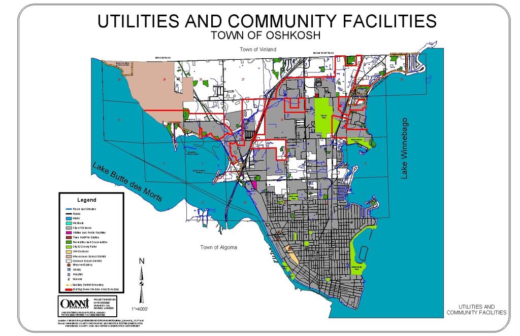
87
88 DEMOGRAPHIC AND LAND USE TRENDS Based on the information presented in the Community Profile Chapter, the average age of residents of the Town of Oshkosh is significantly higher than the age of residents of Winnebago County or the City of Oshkosh. As the baby boom generation ages, the median age will continue to increase. The Town of Oshkosh, like other communities across America, must consider the impact of an aging population in terms of its demand for services and community facilities over the next years. A trend in Winnebago County, and many other areas in Wisconsin, is the decrease in the number of family farms. This phenomenon is the result of many different factors, including minimal profit margins. Also, as baby-boomers age, they are retiring from farming and having a more difficult time finding people who are willing to continue to farm their land. The modern economy is driving youth to cities where jobs offer security, vacation and retirement plans that a farming lifestyle cannot provide. Finally, annexation continues to be a threat to the Town of Oshkosh. It serves as a disincentive for development adjacent to the City of Oshkosh where utilities and community facilities are readily available. This is because the City of Oshkosh has a history of annexing town development that is adjacent to the City, particularly if public sewer is desired. This annexation trend may lead to sprawling development patterns as the Town of Oshkosh seeks additional commercial and industrial development to support the local tax base in areas away from the town s shared boundaries with the City of Oshkosh. This pattern may result in less efficient development patterns, which will increase the potential for land use conflicts and requires costly extensions of local utilities and community facilities. A more desirable option would be to establish a boundary agreement, shared tax revenue plan, or other forms of intergovernmental agreement between the City and Town of Oshkosh to plan for annexation and the impacts thereof. WIRELESS COMMUNICATION INDUSTRY TRENDS Americans are using their cellular phones, pagers, s, and other wireless communication devices more and more frequently. To meet this incredible demand, towers need to be built where people live or travel. In the Town of Oshkosh, this means the USH 41 and USH 45 corridors. To enjoy the opportunity to use cellular phones and other wireless technologies, towers are necessary. Therefore, until cost-effective alternative methods are found to meet cellular service demands, towers are likely to be a part of the future landscape of the Town of Oshkosh. In fact, the wireless industry expects construction of towers to increase with the advent of the wireless Internet service and other PDA (Personal Data Access) devices. Wireless Internet service will require more towers because this form of technology operates at a very high frequency. Whereas today s digital phone towers require towers every 2-3 miles, wireless Internet service requires towers every ¼ mile. Fortunately, these towers are shorter (typically around 80 feet) and therefore can blend into the landscape in much the same way as utility poles do today. Town of Oshkosh Comprehensive Plan - UCF Chapter
89 As described in Chapter 1, the Town of Oshkosh is a rural bedroom community. With a relatively small population, the town s residents cannot create a major demand for cellular service alone. Likewise, with only limited population increases expected, this level of local demand is not expected to significantly increase. However, because USH 41 and USH 45 traverse through the center of the town, motorists using these corridors will continue to use and demand additional cellular services. Moreover, since the FCC, through the provisions of the 1996 Telecommunication Act, is seeking to establish a network of competitive service providers throughout the country, the likely result will be additional towers in the Town of Oshkosh. The Town of Oshkosh wants to maintain its rural character and preserve the town s aesthetic appeal. At the same time, the town would like to ensure that residents maintain their current level of utility and community facility services. Moreover, these services should be provided at a minimum cost to the town. These desires, which actually serve as growth and development policies for the town, drive decisions related to land use, utilities and community facilities. Unfortunately, these desires can conflict with the provision of towers in the Town of Oshkosh. To overcome this apparent conflict, the town will need to work with local providers to pursue alternative tower locations and the use of stealth techniques to camouflage towers located in the Town of Oshkosh. Technological Innovations There is probably nothing more difficult to predict than technological innovations. Future innovations will dictate Town of Oshkosh responses based on land use plans and the natural environment. For instance, ten years ago no one would have predicted the impact of the Internet on society. Twenty years ago, BETA technology was thought to be the wave of the future. The point is clear, technology is an ever-changing force that can have a significant impact on our lives. There are several technologies that are likely to become the next big thing to impact the Town of Oshkosh. What follows is a profile of each. ENERGY CRISIS The recent blackouts and brownouts in California bring to light the energy crisis America is facing. This problem will not fade away and will require every unit of government to address energy needs in a way that is both cost effective and efficient. If and when the town receives applications to construct or install the technologies described below, the town may consult with special experts to ensure that the application of these technologies will not jeopardize public health, safety and welfare. Town policies should reflect that all reasonable costs and expenses associated with such consultations shall be borne by the applicant. Town of Oshkosh Comprehensive Plan - UCF Chapter

90 WIND POWER Wind power has some potential as an alternative energy source. Unlike fossil fuel dependent technologies, wind power does not pollute the environment. Future, more intensive use of this technology will depend on unit cost reductions. One of the nearest successful examples of wind power in Wisconsin is found along Highway 41 south of Fond du Lac. Here, WeEnergies (WE) has two low-speed wind turbines operating. The turbines began operation June 14, Depending on wind speeds, each turbine is designed to produce a maximum flow of 660 kilowatts of electricity, enough electricity to supply about 300 homes with energy. During the course of a year, the wind turbines will generate approximately 3,450 megawatt-hours of electricity. If that power were produced using conventional fossil fuels, there would be 1,956 tons of carbon dioxide emissions; the equivalent of 260 people driving sport utility vehicles for a year. Wisconsin Electric Wind Turbines Fond du Lac County, WI There are proponents and opponents in the Town of Oshkosh to the use of wind power. If this technology were to be seriously pursued in the town, officials must pay careful attention to visual impact on township. Moreover, migratory bird patterns should also be considered before placing a windmill in the Town of Oshkosh. Standards restricting location, height, noise and other issues with respect to the turbines should be included as conditions to any approval to minimize potential impacts on neighboring property owners. If the above concerns can be adequately addressed, wind power can play a viable role in the energy mix to meet future town needs. NATURAL GAS PEAKING PLANTS Electric power demand in northeast Wisconsin has significantly increased over the past decade. In a number of incidents since 1997, various residential and commercial customers have been threatened with blackouts and/or brownouts during peak use periods (usually summer periods). This problem has also been compounded by routine power plant maintenance and unforeseen plant shutdowns. In the fall of 1997, the Public Service Commission determined that there was need to add additional electric power generation in the state by June 1, WE was ordered to supply 250 megawatts of power of the projected 550-megawatt need. The Electric Power Reliability Act (1997 Wisconsin Act 204) supported the PSC plan and provided a schedule for implementation. In order to comply with this order, WE entered into a contract with SEI Wisconsin LLC (a subsidiary of Southern Energy, Inc.). Under the terms of the contract, SEI constructed a natural gas-fired peaking energy facility in the Town of Neenah, Wisconsin. Future needs for the Oshkosh area may also dictate a peaking plant be constructed in the area. In addition to traditional location requirements (zoning, noise, etc.) two specific questions Town of Oshkosh Comprehensive Plan - UCF Chapter
91 must be addressed before a plant can be located in the town. First, will the natural gas supply be plentiful enough to accommodate the needs of existing homes and businesses in addition to a new power plant? And second, can the cooling needs of the power plant be supplied while not adversely affecting groundwater supplies? INTERNET (CABLE CONNECTION SERVICE) In the not too distant future, the Town of Oshkosh may see increasing demand for improved internet speed and connection services, as the internet gains significance in the personal and professional lives of residents. It has been widely predicted that the internet will become a staple in the lives of Americans over the next 10 years in much the same way as the television is a staple in every household. Unlike the television, which is an entertainment device, the internet has the power to change the way people communicate with one another, shop, find entertainment, and work (telecommuting). WIRELESS INTERNET Wireless internet access is just beginning to become available in Wisconsin. As this technology becomes more popular, its demand will likely increase. This service will require additional towers and antennas in the Town of Oshkosh. Some proponents of this technology have gone so far as to predict that in the next 15 years the wireless internet will become as popular as the telephone is today. HIGH DEFINITION TELEVISION High definition television is here. This has resulted in additional towers at existing television tower locations -- to support this improved technology. Fortunately, the Town of Oshkosh does not have a television tower located within its jurisdiction so it may be able to avoid the erection of towers for this purpose within the town boundaries. MEDICAL ADVANCES Advances in medical technologies are clearly helping people to live longer, more productive lives. Medical facilities need to have the capability to accept and integrate new technologies and practices in their scope of care. The facilities serving the Town of Oshkosh consider technological innovations the cornerstone to their success. Therefore, they will likely integrate more and more medical advances in local treatment options. This will result in improved medical care and longer lifespan for residents of the Town of Oshkosh. STEALTH TOWERS There are new technologies that allow flagpoles, fence posts, and streetlights to replace traditional cellular towers (see cell tree at left). However, these alternative locations are not perfect in every situation Tower Flag Pole Distance & Up- Close Views Town of Oshkosh Comprehensive Plan - UCF Chapter

92 and can lead to other problems. For instance, flagpoles can only support one provider. As a result, other companies could request similar flagpole antenna in the same area. This could lead to a picket fence of flagpoles. Nevertheless, the siting of antennas on water towers, silos, electrical utility poles, and other fixtures, which already exist in a community, is an exciting way to minimize the impact of towers. Utilities and Community Facilities Funding Options Cell Tree Many of the utilities and community facilities serving the Town of Oshkosh are provided by other governments and agencies (i.e. county and school districts). As such, they are funded through their general budgets and funding through tax revenues and referendums. The Town of Oshkosh is constantly seeking opportunities to finance needed utilities and community facilities. There are numerous grant and loan programs that the town may seek to help finance needed improvements. These programs are available through the State of Wisconsin and the U.S. Federal Government. What follows is a description of some of the major opportunities available to the town. A major obstacle facing the town when seeking these funds is the town s relatively high median household income. This situation hinders its ability to receiving some forms of funding that are based on community need. WATER AND WASTEWATER GRANT AND LOAN PROGRAM The USDA Rural Development (Rural Utility Service) has a water and wastewater grant and loan program to assist cities, villages, tribes, sanitary districts, and towns in rural areas with a population up to 10,000. The program provides loans and grants to construct, improve, or modify municipal drinking water and wastewater systems, storm sewers, and solid waste disposal facilities. WISCONSIN COMMUNITY DEVELOPMENT BLOCK GRANT PROGRAM The Wisconsin Department of Commerce administers the Wisconsin Community Development Block Grant Program to provide cities, villages and towns with a population of less than 50,000 and all counties except Milwaukee, Dane and Waukesha to obtain matching grants for the installation, upgrade or expansion of municipal drinking water and wastewater systems. For the 2002 funding year, approximately $10 million will be available. Successful applications are based on a distress score, documentation of need, ability to repay, matching fund availability and project readiness. STATE TRUST FUND LOAN PROGRAM The Board of Commissioners of Public Lands provides this loan program with terms of up to 20 years and deeply discounted interest rates. Loans may be used road Town of Oshkosh Comprehensive Plan - UCF Chapter
93 improvements, community centers/halls, trail development, and property acquisition. The funds available fluctuate annually. The current annual loan limit is $3,000,000. RURAL DEVELOPMENT COMMUNITY FACILITY GRANTS The USDA Rural Development also offers grants to communities seeking to build or improve their community buildings (i.e. halls, community center, and fire departments). These grants are awarded to communities with a population up to 10,000 based on a competitive application process. FIRE ADMINISTRATION GRANTS The Federal Emergency Management Administration (FEMA) offers over $100,000,000 in annual grant awards to fire departments for training, fitness programs, vehicles, firefighting equipment, and Fire Prevention Programs. Applicants from communities, which serve a population of less than 50,000, must provide a 10% match. CLEAN WATER FUND The Clean Water Fund Program (CWFP) is one of the subsidized loan programs included in the Environmental Improvement Fund (EIF). The CWFP provides loans to municipalities for wastewater treatment and urban stormwater projects. TOWN CAPITAL IMPROVEMENT PROGRAM/BUDGET A Capital Improvements Program (CIP) is a five to six year plan that is updated yearly, including items such as public building improvements and maintenance, roads, and emergency vehicle purchase and replacement. Capital items are generally defined as those items that are expensive (cost $5,000 or more) and will last at least 3-5 years. The Town of Oshkosh may seek to establish a CIP in the future. If approved, it will be an important tool for implementation of this Smart Growth Comprehensive Plan. STEPS TO DEVELOP A CIP The general steps involved in developing and maintaining a CIP include: 1. Identifying desired capital items. 2. Estimating the cost and means of financing for each item. 3. Comparing the desired expenditures to the budget to determine priorities. This process helps to ensure that improvements are made in a logical order and do not surprise local officials or taxpayers. Coordination with Other Comprehensive Plan Elements Utilities and community facilities can dictate future planning for a community if capacity, location, and services are not adequate to support development. Therefore, it is important to inventory existing utilities and community facilities and understand how utilities and community facilities will be provided over the planning period. Furthermore, utilities and community facilities have a direct impact on the other elements of the comprehensive plan. In particular, the Housing, Economic Development, Land Use, and Intergovernmental Coordination Elements are most directly impacted. Town of Oshkosh Comprehensive Plan - UCF Chapter
94 HOUSING Improvements such as roads, sewer, water, parks, recreational facilities and schools all need to be coordinated with the housing decisions and vice versa. The best method to coordinate improvements is to follow the land use pattern presented on the Future Land Use Maps as closely as possible and plan for future improvements. This approach will greatly enhance the efficiency of capital improvements expenditures. To provide further assistance in these efforts, the town may consider the use of a capital improvement plan as a tool to help organize and plan for future capital expenditures. ECONOMIC DEVELOPMENT The availability of utilities like sewer, water, electricity and communications services is critical to economic development. This infrastructure is needed to support business and industrial growth in the Town of Oshkosh. Therefore, the goals and objectives of this chapter seek to maintain, and where feasible, improve local utilities and community facilities to improve economic development opportunities in the Town of Oshkosh. LAND USE ELEMENT Land use dictates the need for utilities and community facilities. Inversely, the availability of utilities and community facilities can dictate where development can occur. The Future Land Use Maps were developed after careful consideration of where needed utilities and community facilities are now available, or will be available, within the planning period. In addition, the Future Land Use Maps carefully consider the economic feasibility of utility and community facility extensions to serve areas planned for future development. Areas where the extension of sewer service, communication services, or power supplies is cost prohibitive, are not encouraged for future residential, commercial or industrial development in the town. INTERGOVERNMENTAL COORDINATION As is obvious from this chapter, utilities and community facilities are not provided solely by the Town of Oshkosh. Utilities and community facilities that serve the area are provided by Winnebago County, private companies and neighboring communities. It is important that utilities and community facilities continue to effectively serve the Town of Oshkosh. Therefore, continued coordination is essential to ensure that development in the Town of Oshkosh is compatible with local utility and community facility capacities. Goals and objectives included in this chapter, as well as the Intergovernmental Coordination Element, support continued coordination to efficiently provide needed utilities and community facilities to the Town of Oshkosh. Town of Oshkosh Comprehensive Plan - UCF Chapter
95 Goals and Objectives It is the goal of the town that all future utilities and community facilities needs will be met through the year 2020 (and beyond). Though many of these facilities will be located outside of the town limits, they will be easily accessible in nearby cities and villages. The services provided will also meet the special needs of the elderly and youth populations in the town. The Town of Oshkosh will support the continued efforts of neighboring communities, school districts, Winnebago County, and private companies, which provide community facilities and utilities which can be used by town residents. Because the Town of Oshkosh has a minimal amount of control over resource allocations in neighboring communities and school districts, the goals in this section are related to actions that the town can control. The Town of Oshkosh will work, in accordance with the Intergovernmental Coordination Element of the Wisconsin Smart Growth Law, with neighboring communities and school districts to ensure that adequate community and utilities facilities are available to serve the area. OVERALL GOALS 1. Provide efficient, cost-effective sanitary sewer service and/or permit private, code -compliant technologies while maintaining the rural character of the town. 2. Support the continued operation of community facilities provided by Winnebago County, City of Oshkosh, local school districts, private companies and other neighboring communities, which serve residents of the Town of Oshkosh. 3. Seek to ensure that all development is served by adequate utilities. OBJECTIVES 1. Work with the local sanitary districts and the City of Oshkosh to coordinate the orderly extension of services. As part of this effort, coordinate with the Butte Des Morts Sanitary District to monitor new development and loadings to the wastewater treatment plant in order to determine the appropriate time for the district to initiate facility planning efforts to address potential capacity or treatment deficiencies. 2. As desirable, issue permits for innovative waste treatment systems (pursuant to the requirements of COMM 83) that will provide safe and effective results for commercial development opportunities near USH 41 and USH 45, as well as rural development in accordance with the Future Land Use Maps. 3. Work with Winnebago County, and if necessary adopt a town policy and supporting zoning requirements, to encourage developers to consider alternative waste treatment systems in support of innovative subdivision designs (i.e. cluster and conservation subdivisions) 4. Seek to inform residents of the Town of Oshkosh about available community facilities in the area through a community newsletter and web site, particularly to ensure that populations in need can obtain services. 5. Coordinate with Winnebago County to ensure that the county cellular tower ordinance provides adequate protection and provisions for the Town of Oshkosh. The ordinance should encourage co-location, stealth technologies, and other techniques to minimize the visual impact of cellular towers. Furthermore, the ordinance should address policies with respect to the location of towers on town property. 6. Complete all requirements stipulated by the EPA Stormwater Phase II Regulations in accordance with Federal and State Laws. Town of Oshkosh Comprehensive Plan - UCF Chapter


96 Introduction 7.0 AGRICULTURAL, NATURAL & CULTURAL RESOURCES This chapter provides an inventory of existing agricultural, natural, and cultural resources in the Town of Oshkosh. In addition, issues associated with these resources are discussed and a vision, with supporting goals and objectives, is presented. Vision Primary agricultural areas, woodlands, wetlands and other natural areas in the Town of Oshkosh are protected from development and are primarily located within conservation subdivisions. Commercial farming operations consist COMMUNITY SURVEY RESULTS 90% of respondents felt maintaining rural character is important. 81% of survey respondents support efforts to preserve farmland. mainly of small, niche farms and rented cropland which are an integral part of the town s open space network and conservation subdivision developments. Farmland and natural areas enhance the rural character of the town by maintaining open vistas and providing buffers between residential areas to maintain the low, rural density of development pattern desired by residents. As has been the tradition, cultural and entertainment venues are easily accessible in nearby urban centers via USH 41 and USH 45 in the greater Oshkosh/Fox Cities region. Agricultural Resources The Town of Oshkosh has a farming history and tradition that has attracted many residents to the area. At one time, farming operations were the primary base of the local economy and defined the rural character of the town. As the population has increased, as more homes have been built, as more nonresidential development has occurred, as highways have been developed, and as more land has been annexed to the City of Oshkosh, farming operations have been disappearing from the landscape. This trend is of great concern to town residents. In the Town of Oshkosh Community Survey conducted in the fall of 2000, the majority of residents (81%) felt that farmland Town of Oshkosh Comprehensive Plan - Agricultural, Natural & Cultural Resources Chapter7.0 93
97 preservation is important. Likewise, an overwhelming majority (90%) of residents felt that maintaining the town s rural setting is very important or important to the future of the Town of Oshkosh. Furthermore, 79% of the respondents either strongly agreed or agreed that growth should be managed to preserve farmland in the town. Similar priorities are also clearly reflected in the Value Statements and SWOT results as presented in the Introduction and Issues and Opportunities Chapters of this plan. Therefore, preservation of farming is an important consideration when planning for future growth in the Town of Oshkosh. SOIL ASSOCIATIONS 1 Primary farmlands are best understood based on soil types. Soils support the physical base for development and agriculture within the town. Knowledge of their limitations and potential difficulties is important in evaluating crop production capabilities and other land use alternatives, such as residential development. A map of soil types in the Town of Oshkosh is provided on the following page. The town consists of five main soil types: Kewaunee Silt Loam, Manawa Silty Clay Loam, Poygan Silty Clay Loam, Korobango Silt Loam, and Hortonville Silt Loam. Appendix G provides building and sanitary limitation maps based on soil characteristics. The majority of the soils in the town are of the Kewaunee association (shown in pink). These soils are gently sloping and well drained. Typically the surface layer is silt loam or loamy fine sand. Development, with or without basements in these soils, faces severe risk due to low baring strength. Due to their slow perking qualities, these soils are not recommended for septic tank absorption fields. Most areas of this soil classification are farmed. Manawa soils (shown in lime green) are classified as nearly level to gently sloping, somewhat poorly drained and slowly permeable. Typically, the surface layer is silty clay loam and the subsoil is mostly silty clay. Development, with or without basements, faces the potential for severe wetness, flooding and subsidence. Due to their slow perking qualities, Manawa soils are not recommended for septic tank absorption fields. With respect to farming, these soils have slow permeability and surface runoff. If drained, and timely conservation tillage is practiced, these soils can overcome their limitations to support cultivated crops, hay and pasturelands. Yields on undrained soils are limited by excessive wetness. 1 The information presented in this section is based on information from the Winnebago County Soil Survey and the Winnebago County Land and Water Management Plan. It has been the experience of the Planning Advisory Committee that the soils maps available for the town are not always accurate. As a result, the conditions these soils indicate (i.e. building suitability) are not always true. In many instances, residents have successfully constructed homes without basements in areas of unsuitable soils. The town would encourage the county and appropriate state agencies to invest in new soil association mapping of the Town of Oshkosh. Moreover, based on existing requirements, any areas to be developed without sewer and water are required to conduct a site specific soil survey to verify soil types. Town of Oshkosh Comprehensive Plan - Agricultural, Natural & Cultural Resources Chapter7.0 94
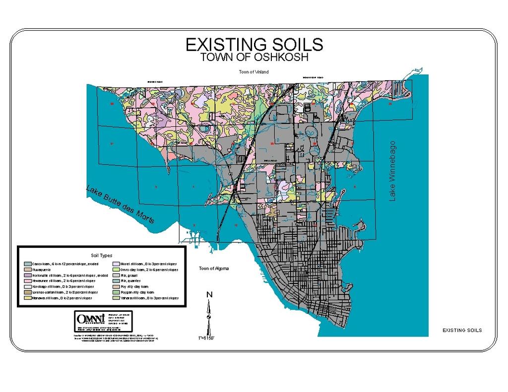
98

99 The Poygan Silty Clay Loam soils are located adjacent to USH 41 in Sections 26, 27 and 34. As an agricultural soil, the Poygan Silty Clay Loam faces several limitations. This soil is subject to frequent flooding and ponding. In addition, permeability is slow and available water capacity is moderate. The shrink swell potential is also moderate. If drained, these soils have the potential for cultivated crops, hay and pastureland. Timely conservation tillage can help overcome limitations. Returning crop residue or regularly adding manure improves tilth and increases water infiltration. Obtaining suitable drainage outlets is a problem in many areas. The Korobago Silt Loam soils (shown in gray) are located mainly in section 25 and 30, east of USH 41 in the Town of Oshkosh. These soils are considered somewhat poorly drained and are found in drainage ways. The soil is subject to occasional flooding and ponding. It has good potential for cultivated crops, hay and pasture. If drained, the soil is suited to corn, soybeans, and small grain. Finally, the Hortonville Silt Loam soils (shown in lavender) are found in the northernmost portion of the town near Lake Winnebago and Lake Butte des Morts. Like the Korobago, Hortonville Silt Loam soils are classified as having good potential for farming of cultivated crops, including corn, soybeans and small grains. The soil is also productive for hay and pastureland. FARM OWNERSHIP The primary issue with farmland preservation in the Town of Oshkosh is that much of the remaining farmland is owned by a very small group of individual farmers. Faced with development pressures, retirement needs, and a worsening farm economy, farmers see the sale of their land for development as an attractive financial opportunity. There seems to be an endless supply of urban dwellers that want to fulfill their dream of living in the country. In order to maintain open areas of farmland in the township, which are large enough to support either a small family farming operation or serve as rental fields, creative development options must be explored. PURCHASE AND TRANSFER OF DEVELOPMENT RIGHTS PROGRAMS Information about PDR and TDR programs, as tools for protecting farmland and natural areas, is provided in the Implementation Chapter of this plan. Town of Oshkosh Comprehensive Plan - Agricultural, Natural & Cultural Resources Chapter7.0 96

100 CONSERVATION SUBDIVISIONS A TOOL TO PROTECT FARMLAND One method to protect farmland, while minimizing conflicts with residential development, is the use of conservation subdivisions. Conservation subdivision designs encourage the preservation and protection of open space, natural areas and farmland resources. In a conservation subdivision, homes are clustered together on smaller lots so that a greater proportion of the land is protected from development. In areas of the Town of Oshkosh where municipal sewer is unavailable, innovative sewer treatment systems permissible through COMM 83 may make this clustering possible. COMMUNITY SURVEY RESULTS Conservation subdivision is a land use tool that residents feel is important. Sixty-two percent (62%) of survey respondents favored use of this tool, while another 10% were willing to consider it. Typically, a conservation subdivision will require at least 50% of a site be protected from further development. Protection and maintenance of the conserved area can be accomplished through a conservation easement with an appropriate conservation organization, land trust, neighborhood association or government body, or through deed covenants. The areas to be conserved must be protected in perpetuity. The land designated for protection should either be left as natural habitat, open space, or farmland. In conservation subdivisions, the development of walking and bicycle trails is encouraged, particularly to provide limited access to protected natural areas. THE RIGHT TO FARM Wisconsin has a right-to-farm law protecting farms from nuisance lawsuits related to typical farm noise and odors. As residential development expands into farmland areas, it is inevitable that these issues develop. Often the issues relate to manure spreading and storage. People who move to rural areas near farmland are not aware of these and other potential nuisances. To minimize conflicts, education is strongly recommended. By educating new landowners about potential conflicts, surprise nuisances can be avoided. CONCENTRATED ANIMAL FEEDING OPERATIONS (CAFOS) Concentrated Animal Feeding Operations (700+ cattle), or mega farms, are increasing in number in Wisconsin. In 1985, there was 1 such operation in the state. By 1990, 24 operations and by 2000 there were 77 mega farms in Wisconsin. Generally, CAFOs locate in rural areas where conflicts with neighboring property owners can be minimized. The farmland in the Town of Oshkosh is in close proximity to USH 41 and residential development. Moreover, land prices are higher than similar farmland prices in neighboring, more rural, towns. As a result, it is Town of Oshkosh Comprehensive Plan - Agricultural, Natural & Cultural Resources Chapter7.0 97
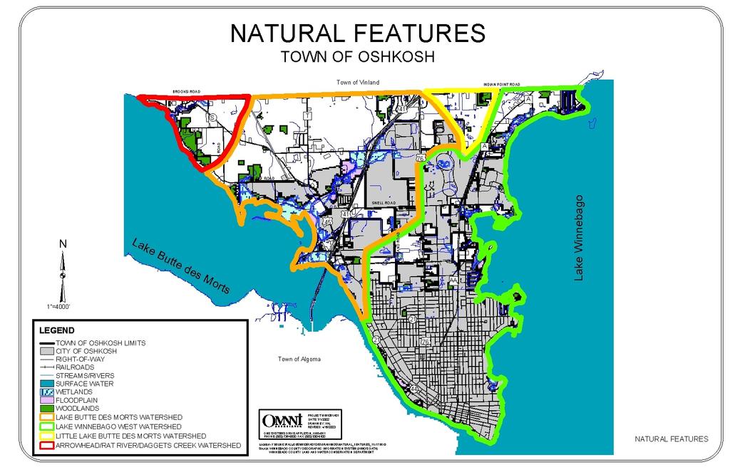
101
102 not likely that a mega farm will be established in the town. Furthermore, given the developing environment and residential character of the town, mega farms would not be feasible. Should such a farm be proposed, the Winnebago County Zoning Ordinance, as well as the Wisconsin Department of Natural Resources, have extensive standards and permit requirements that must be met, however the WDNR permit does not have any control over the location of a CAFO. COMMUNITY SURVEY RESULTS Natural Resources and Environmental Concerns 2 Natural resources help to determine the potential for land development. Likewise, environmental characteristics indicate the ability of the land to support various types of development. Geology, topography, drainage patterns, floodplains and wetlands are among the natural and environmental features, which determine if an area is physically suitable for specific types of uses. 91% of survey respondents felt that managing the natural environment is important or very important. 87% of respondents either strongly agree or agree that growth should be managed to prevent flooding. Preservation of natural resources (wetlands, surface and ground water, woodlands, shorelines) is an important priority for the Town of Oshkosh. These resources enhance the quality of life for residents, while also providing recreational opportunities to help sustain the local economy. GEOLOGY, TOPOGRAPHY, AND DRAINAGE The entire landscape of Winnebago County reflects the influences of glacial activity. The most recent glacier to cover the county occurred about 10,000 year ago. It covered all but the southwestern part of the county and deposited the reddish, clayey till. The topography in the town can best be described as nearly level or gently rolling, with slopes of 6% or less covering 90% of the terrain. Not surprisingly, the lowest areas of the town are found along the Lake Winnebago and Lake Butte des Morts shorelines, where the elevations are approximately 750 feet above mean sea level. The elevations in the town rise approximately feet toward the northern portions of the township adjacent to the Town of Vinland. Winnebago County, which is in the Lake Michigan drainage area, is within the drainage basin of the Fox River and its principal tributary, the Wolf River. The Fox River rises in Columbia County, enters Winnebago County near Eureka, flows northeastward through Lake Butte des Morts and Lake Winnebago, leaves the county north of Menasha and then flows northeastward to the Bay of Green Bay where it empties into Lake Michigan. Lake 2 Information used to develop this section was obtained from: Soil Survey of Winnebago County, United States Department of Agriculture Soil Conservation Service, Winnebago County Land & Water Resource Management Plan, Winnebago County Land and Water Conservation Department, Town of Oshkosh Comprehensive Plan - Agricultural, Natural & Cultural Resources Chapter7.0 99

103 Winnebago divides the river into the upper and lower Fox River. The Wolf River rises in Forest County, enters Winnebago County in the northwest corner, and then flows south and east through Lake Poygan and Lake Winnebago to Winneconne. It flows into Lake Butte des Morts just south of the Village of Winneconne. Drainage in the Town of Oshkosh flows to Lake Butte des Morts to the South and West and Lake Winnebago to the East. SURFACE WATER (NAVIGABLE WATERS) Winnebago County has more surface acres of water than any other county in Wisconsin. About 23 percent of the county, or 84,000 acres, is water. Lake Winnebago is the largest lake in Winnebago County and the State of Wisconsin. It forms most of the eastern boundary of Winnebago County and is the eastern boundary of the Town of Oshkosh. About 28 miles long and 10 ½ miles wide, Lake Winnebago covers 137,708 acres. Its maximum depth is 21 feet. The other significant water feature in the area is Lake Butte Des Morts. Lake Butte des Morts has a maximum depth of 11 feet and covers 4,505 acres. The Winnebago Pool System of lakes, rivers, and streams is one of Wisconsin s most significant water resources, representing 17% of the State s total surface water acreage. Given the abundant water resources in the area, water-based recreation is a major industry in Winnebago County. Recreational use for fishing, boating, swimming, hunting and trapping are common. In addition, some aquatic plants are harvested commercially from the lakes and an active commercial setline fishery for catfish also exists in the county. Lake Winnebago is host to many fishing tournaments in the surrounding area. These tournaments result in a multi-million dollar benefit to the local economy. In Winnebago County, Lake Winnebago alone provides drinking water to over 100,000 people in the cities of Oshkosh, Neenah and Menasha. Therefore, quality surface water resources are important to the economic well being of the county. The surface water in the Winnebago System has historically been fertile, and can best be described as highly eutrophic. This is the direct result of runoff from nonpoint pollution sources (i.e. lawn fertilizer). Excessive nutrient and sediment delivery into the surface waterways from agricultural and urban sources contributes towards massive algae blooms that occur with increasing frequency. The algae and sediments increase turbidity, hinder growth of beneficial aquatic plants, and deplete important fish spawning areas. It also significantly increases the treatment costs for potable and industrial use water. The Winnebago County Land and Water Conservation Department and the Wisconsin Department of Natural Resources work together to protect the quality of surface water in the county. The town supports water-based habitats, such as cane beds, natural shorelines, and, where appropriate, rock rip rap. The town believes water quality is important in order to ensure the continued success of recreational activities such as fishing and duck hunting. The town also feels it is important to protect water quality and Town of Oshkosh Comprehensive Plan - Agricultural, Natural & Cultural Resources Chapter
104 integrity of fishing hot spots within the Winnebago Pool system. This would include the natural vegetation that supports good fish habitat, such as coves along the Lake Butte Des Morts shoreline, Garlic Island, deep water marshes, etc. The County Land and Water Conservation Department also has cost-share opportunities for local communities to help protect and enhance water quality. Grant money exists for shoreline protection/stabilization projects. GROUNDWATER & AQUIFERS Groundwater is the primary source of drinking water for residents of the Town of Oshkosh. The main water supply aquifer in the area is the St. Peter sandstone aquifer. Lesser quantities of groundwater are found in the overlying Platteville-Galena dolomite. Recharge to the sandstone aquifer percolates through the glacial drift and semi-permeable dolomite from above, and also enters the sandstone from areas northwest of the Town, since the sandstone dips to the southeast. The shallow groundwater in the Town of Oshkosh flows to the east into Lake Winnebago. The overall quality of groundwater in the Town of Oshkosh is generally considered to be of good quality. Groundwater from the St. Peter sandstone aquifer is saline and very hard, with hardness ranging from 600 to 2,200 ppm, increasing from west to east in the town. Sulfate concentrations are also elevated in the eastern part of the town. Elevated arsenic levels have been found in groundwater samples from the town. It is strongly suspected that these concentrations are associated with the mineralogy of the upper St. Peter sandstone. The DNR has established an Arsenic Advisory Area in Outagamie and Winnebago Counties, which encompasses the Town of Oshkosh. The DNR recommends that supply wells within the Arsenic Advisory Area be cased through the upper portion of the St. Peter sandstone, and that water be sampled, and treated, if necessary. As more development occurs, the potential for arsenic in wells increases. Private well owners in the town can take several steps to reduce their exposure to arsenic. First and foremost, wells should be tested regularly at least once per year and anytime a change is watercolor, taste or odor is noticed. If the test exceeds 10 parts per billion for arsenic, water from the well should not be used for drinking or cooking. In these situations, residents can buy bottled water, rebuild their well to more stringent specifications than required under current well codes, or pursue a treatment option. The Wisconsin Department of Commerce has approved two categories of devices for the removal of arsenic Point of Use (POU) and Point of Entry (POE). Town of Oshkosh Comprehensive Plan - Agricultural, Natural & Cultural Resources Chapter
105 POU devices are used to treat water at the point of use such as a single tap. Distillation units provide safe water in batches while Reverse Osmosis (RO) units can be installed on a single tap. POE treatment systems treat all water entering the home. Either type of system must be properly installed and maintained to reliably remove the arsenic from drinking water. Contamination risks from land use practices are also a threat to groundwater resources. Potential contaminant sources include nitrates from failed septic systems or farm runoff, pesticides, fertilizers, leaking underground storage tanks, quarry sites and road salt. Old and unregulated landfills are also a threat to groundwater. There are no landfills in the town, but two exist immediately adjacent to the Town in the City of Oshkosh (one closed landfill on Snell Road and the Winnebago County Landfill on CTH Y). These facilities are potential threats to the groundwater quality. The town does not support the establishment of new landfills in the town. Fortunately, all of these potential groundwater threats are presently regulated or are being addressed through ordinances or technical assistance services by various county and state agencies. Over-pumping of the aquifer does not seem to be an issue, since the Winnebago Mental Health Facility and the state prison, which were formerly the two largest groundwater users in the Town, have been annexed by the City of Oshkosh. The City supplies municipal water, drawn from Lake Winnebago, to these users. WATERSHEDS 3 The Town of Oshkosh is included in three water basins (Wolf River, Upper Fox River and the Lower Fox River) and four watersheds. What follows is a profile of each watershed. The locations of the water basins and watersheds are depicted on the Natural Features Map provided in this chapter. The Lake Winnebago West Watershed is a long, narrow watershed, located on the west shore of Lake Winnebago. It includes a drainage area of approximately 16 square miles. The primary use of land is urban/developed. It includes the entire City of Oshkosh north of the Fox River and extends north to Davis Point in the southeast part of the City of Neenah. The Towns of Oshkosh, Vinland, and Neenah stretch between. There are no major streams in the watershed, but there are several unnamed tributaries that drain directly into Lake Winnebago. The extent of urban development is expected to increase in this watershed; consequently, the significance of urban runoff can be expected to increase in the future. The Lake Butte des Morts Watershed encompasses much of the central portion of the Town of Oshkosh. The entire watershed encompasses approximately 73 square miles. 3 Source: Winnebago County Land and Water Resource Management Plan, Copies are available from the Winnebago County Land and Water Conservation Department. Town of Oshkosh Comprehensive Plan - Agricultural, Natural & Cultural Resources Chapter
106 The most dominant land use is agriculture, but this watershed is rapidly urbanizing due to its close proximity to the City of Oshkosh. The Arrowhead/Rat River/Daggets Creek Watershed includes a small portion of the Town of Oshkosh immediately south of the Butte des Morts Community in the Town of Winneconne. In this area, Daggets Creek is the primary water feature. It has a drainage area of 11.5 square miles and is primarily adjacent to agricultural land. Daggets Creek flows southeasterly for 4.3 miles before entering Lake Butte des Morts just north of Plummers Point Road. In the Town of Oshkosh, much of this stream has been converted to a dredged channel up to 50 feet wide. Lands adjacent to this cannel have been largely subdivided and developed. A small central portion of the town along the boundary shared with the Town of Vinland is in the Little Lake Butte des Morts Watershed. This is the only watershed in the county within the Lower Fox River Basin. It has a drainage area of about 50 square miles and includes large portions of the cities of Neenah and Menasha. Additional information about the care, management, and plans for the watershed is available from the Winnebago County Land and Water Conservation Department. The department has adopted a Land and Water Resource Management Plan to address habitat, water quality, and other issues in these watersheds. SHORELINES Residents of the Town of Oshkosh enjoy Lake Winnebago and Lake Butte Des Morts shoreline. Shoreline areas are critical to the overall quality of life in the town and contribute significantly to the character of the community. The town has approximately 4 miles of Lake Winnebago shoreline and 6 miles of Lake Butte Des Morts shoreline. According to the Winnebago County Land and Water Conservation Department, the Lake Winnebago and Lake Butte Des Morts shorelines include a mixture of undeveloped (natural, forested, and wetland) areas and rural residential development. The Lake Winnebago shoreline in the Town of Oshkosh is fairly well stabilized by comparison to the number of breeches in the Town of Oshkosh along Lake Butte des Morts. According to the most recent inventory of the Winnebago System (completed in 1996), about 10,000 feet of Lake Butte des Morts shoreline in the Town of Oshkosh is experiencing some level of damage through erosion. Wave action caused by increased boat and jet ski traffic/wakes, wind, artificially high water levels and weather are factors for the erosion. Winnebago County has grant money available for municipalities to help pay for shoreland protection measures. Town of Oshkosh Comprehensive Plan - Agricultural, Natural & Cultural Resources Chapter
 regulates the stabilization and fill of shorelines in the town.")
107 The Shoreland/Wetland Ordinance adopted by Winnebago County regulates shoreland uses and development within 1,000 feet from the ordinary high water mark of a lake, pond or flowage, and within 300 feet from the ordinary high water mark of a river or stream. The Wisconsin Department of Natural Resources (WDNR) regulates the stabilization and fill of shorelines in the town. The WDNR has a strong history of working well with residents on these issues. The Town of Oshkosh supports the preservation of natural shoreline areas versus manmade seawalls. Undeveloped and restored natural shorelines, with woods, meadows, and marshy areas provide recreational opportunities, including hunting and fishing. Natural shorelines help protect water quality by slowing runoff, reducing erosion, and filtering nutrients that can result in algae blooms. They also provide habitat for wildlife. In addition, natural shorelines add beauty and color to a property and increase privacy. WETLANDS & FLOODPLAINS Wetlands act as a natural filtering system for sediment and nutrients such as phosphorus and nitrates. They also serve as a natural buffer, protecting shorelines and stream banks from erosion. Wetlands are essential in providing wildlife habitat, flood control, and groundwater recharge. Due to these benefits, county and state regulations place limitations on the development and use of wetlands and shorelands. Wetlands in the town are shown on the Town of Oshkosh Natural Features Map. For almost three decades, the U.S. Army Corps of Engineers has had the authority over the placement of fill materials in virtually all wetlands of five (5) acres or greater. However, on January 9, 2001, the U.S. Supreme Court limited federal jurisdiction over isolated wetlands under the Clean Water Act of This Court decision now limits the jurisdiction of the U.S. Army Corps of Engineers to cover only wetlands that are directly associated with navigable waterways-lakes, streams and rivers. Since the State of Wisconsin s jurisdiction over wetlands is tied to federal statutes, as many as 4 million acres of wetland were affected by this decision, including some wetland areas in the Town of Oshkosh. BENEFITS OF WETLANDS Wetlands act as a natural filtering system for sediment and nutrients such as phosphorus and nitrates. Wetlands serve as a natural buffer, protecting shorelines and stream banks from erosion. Wetlands are also essential in providing fish & wildlife habitat, flood control, and groundwater recharge. In response to this U.S. Supreme Court Decision the State of Wisconsin recently passed legislation giving the Wisconsin Department of Natural Resources (WDNR) authority to regulate those wetlands that were formerly tied to federal legislation. As in the past, anyone interested in filling a wetland is required to obtain a permit. Floodplains serve many important functions related to flood and erosion control, water quality, groundwater recharge and fish and wildlife habitats. The Town of Oshkosh Natural Features Map illustrates floodplain areas found in the town. The map clearly Town of Oshkosh Comprehensive Plan - Agricultural, Natural & Cultural Resources Chapter

108 shows that most of the town s floodplain areas are located adjacent to Lake Winnebago, Lake Butte Des Morts and the numerous inland creeks, streams, and ditches which flow through the town. Generally, areas susceptible to flooding are considered unsuitable for development due to potential health risks and property damage. Therefore, the Future Land Use Maps discourage development in these areas. WOODLANDS Prior to settlement, the vegetation of Winnebago County was mostly forest and oak savanna. As people moved to the area, most of the forests were cleared for agricultural crops. Today, approximately 20,000 acres of land are still in woodland cover. The WDNR Managed Forest Law provides opportunities for conservation of contiguous woodland environments for wildlife and plants inhabiting these areas. For more information visit : publications/. Several small areas of woodlands are scattered around the Town of Oshkosh. The Town of Oshkosh Natural Features Map delineates the location of many of these areas. Because woodlands are an important natural feature to town residents, the remaining woodland areas should be protected from future encroachment through the use of easements, conservation subdivisions, land trust activities, and other preservation techniques. Part of this protection effort should include education for private landowners and developers about the importance of woodlands. WILDLIFE HABITATS Resident observation is the best available local resource to identify wildlife habitat areas. Primary wildlife habitat areas correspond to the forested areas, wetland areas and shorelines shown on the natural resources map. These areas provide food for deer, raccoons, fox, herons, bald eagle and other small creatures common in the area. The local farm fields also serve as a food source for deer, geese, sandhill cranes, and waterfowl in the area. Farmland is also a very important local wildlife habitat that provides travel corridors between waterways, woodlands and grasslands. Farmland also provides cover opportunities and large contiguous open spaces needed by wildlife. Urban nuisance wildlife (i.e. skunk, raccoon) is becoming more common in the town due to urban sprawl. WILDLIFE HABITAT FRAGMENTATION A primary threat to wildlife if fragmentation -- the breaking up of larger habitat areas into smaller sections. Fragmentation decreases wildlife population sizes, isolates habitat areas and creates more edges where two dissimilar habitats meet (i.e. grassland and residential subdivisions). The remaining areas of the town (i.e. residential areas, road corridors, and other developed areas) are not classified as primary wildlife habitat areas - though certainly animals do wander into these areas. Lake Butte des Morts and Lake Winnebago are also major waterfowl, fish spawning, reptile and amphibian habitat areas. An integral part of the wildlife habitat is wildlife corridors. These areas provide vital connections between habitat areas that have been fragmented due to road construction, development, etc. The Town of Oshkosh considers wildlife corridors an important part Town of Oshkosh Comprehensive Plan - Agricultural, Natural & Cultural Resources Chapter
109 of the natural environment and supports efforts to create and maintain these areas. Fragmenting the wildlife habitat can decrease the population size, isolate habitat and result in more vehicle-animal accidents. It can also create edges, in which case, the outcome results in conflicting land uses on adjacent properties. EXOTIC AND INVASIVE SPECIES Non-native, or exotic, plant and animal species have been recognized in recent years as a major threat to the integrity of native habitats and species, as well as a potential economic threat (damage to crops, tourist economy, water quality etc). The WDNR requires that any person seeking to bring a non-native fish or wild animal for introduction in Wisconsin obtain a permit. The town can help combat exotic species by educating residents about non-native species and encouraging residents to use native plants in landscaping. Of particular concern to the Town of Oshkosh are the zebra mussels that are now present in Lake Winnebago and Lake Butte des Morts. They have the potential to change the entire ecosystem of the lakes. The WDNR is currently studying their impact in the area. Purple loosetrife is an invasive plant specie that is also very common in the town and continues to threaten native species. The town supports research and control of this aggressive plant specie. THREATENED AND ENDANGERED SPECIES There are many threatened and endangered plant and animal species in Winnebago County. Specifically, the Forster s Tern, Red-Necked Grebe, Wood Turtles, Blanding s Turtles, Marsh Blazing Star (plant), Broad-Winged Skipper (butterfly), Banded Killfish, and the Lake Sturgeon are just a few. Due to the sensitivity of locating these species, specific locations are not available to the general public. The town supports protecting both the habitat and the species themselves. The WDNR is attempting to identify and catalog endangered plant and animal species across the state. For a complete, up-to-date list of endangered plant and animal species in the town, refer to A Winnebago County Map of endangered species available on-line at: METALLIC AND NON-METALLIC MINING RESOURCES The town does not promote expansion of present nor development of new quarries. The geologic and glacial history of the county is reflected in its mineral resources that provide a substantial volume of total aggregate material used in construction activities throughout the county and the region. Some of the best quality limestone is found in Winnebago County. This material is an excellent source of rock riprap that is used extensively for shoreline and stream bank protection throughout the county. The town has one active non-metallic mining operation. This facility is called the Grundy Quarry and is located off County Road Y. This limestone quarry is registered with the Wisconsin Department of Commerce as pit number operated by Michels Town of Oshkosh Comprehensive Plan - Agricultural, Natural & Cultural Resources Chapter
110 Materials (WDC, March 2001). No other metallic or non-metallic mining operations are found in the town, nor are there plans to establish such a use in the future. As part of NR 135, Wisconsin Administrative Code, adopted in December 2000, any community in Wisconsin could adopt an ordinance to establish requirements for reclamation of non-metallic mines, such as gravel pits and rock quarries. If a town decided not to develop its own ordinance, a county could develop one, which would also regulate operations in the town. Likewise, regional planning agencies could develop ordinances for counties within their region. The ordinances must establish reclamation requirements to prevent owners and operators of quarries and gravel pits from abandoning their operations without proper reclamation of the mines. The East Central Wisconsin Regional Planning Commission (ECWRPC), under an agreement approved in July, 2001 will be the Regulatory Authority for administering five individual, county-adopted, Non-Metallic Mining Reclamation Ordinances for Winnebago, Calumet, Outagamie, Waupaca and Shawano Counties. This agreement transfers permit issuance and reclamation plan review/approval authority to the ECWPRC for the program, however, the individual counties will still be responsible for the actual enforcement of the ordinance requirements should any problems arise with a site/operator/landowner. It is important to understand that the ECWPRC only oversees the reclamation aspect of active sites in these counties as it relates to the NR-135 requirements. Zoning or other operational issues of sites are still handled by the counties, including Winnebago, under their existing zoning regulations. The process of siting a mine continues to be a local matter governed under existing zoning procedures by local authorities. The new reclamation requirements through NR 135 add to the status quo but do not replace or remove any other current means of regulation. The requirements neither regulate active mining process nor have any effect upon local zoning decisions like those related to the approval of new mine sites. The Grundy Quarry, operated by Michels Materials, has grand-fathered status with respect to the Winnebago County Zoning Ordinance. The quarry has received a reclamation permit from the East Central Wisconsin Regional Planning Commission under NR-135 (Permit No ). The permit identifies 23 "active" (un-reclaimed) acres for the year 2001 with a possible 7 acres remaining in the western portion of the site for future extraction (this 7 acres would require approval from the Town of Oshkosh and Winnebago County). The permit application stated that there are at least 20 years worth of material remaining in the quarry. A reclamation plan will need to be prepared to the standards of the new ordinance and be submitted to the East Central Wisconsin Regional Planning Commission for review by May 15, The Town of Oshkosh will be notified at that time for comments. AIR QUALITY The following information is from the Wisconsin Department of Natural Resources: Town of Oshkosh Comprehensive Plan - Agricultural, Natural & Cultural Resources Chapter
111 A few common air pollutants are found all over the United States. These pollutants can injure health, harm the environment and cause property damage. EPA calls these pollutants criteria air pollutants because the agency has regulated them by first developing health-based criteria (science-based guidelines) as the basis for setting permissible levels. One set of limits (primary standard) protects health; another set of limits (secondary standard) is intended to prevent environmental and property damage. A geographic area that meets or does better than the primary standard is called an attainment area; areas that don't meet the primary standard are called nonattainment areas. Winnebago County is an attainment area. This situation is not expected to change in the future. County, state and federal air quality protection standards are in place to maintain and improve the local air quality. The nearest air quality monitoring station is located in the City of Oshkosh. The local transportation network can also influence air quality. Condensed development (conservation subdivisions) and sound land use decisions regarding development and the need for roads must be considered to help reduce air emissions. Historical and Cultural Resources Cultural resources, like natural resources, are valuable assets, which should be preserved. At this time, there are no officially designated historic districts or properties in the town. The Winnebago County Historical and Archeological Society is charged with identifying and protecting historic properties and sites in the area. CHURCHES While there are no churches located in the town, numerous facilities exist in nearby communities. Town residents have easy access to these nearby facilities via town and county roads and the USH 41 and USH 45 corridors. MUSEUMS/HISTORIC RESOURCES Museums protect valuable historic resources for community enjoyment. There are several museums and other historic resources located in nearby communities. Residents of the town are welcome to visit these facilities and enjoy the exhibits and other amenities they have to offer. While the town would welcome a local museum and encourage residents who want to establish a historic or special district, there are currently no plans to do so. NATIVE AMERICAN ARTIFACTS Winnebago County, including portions of the Town of Oshkosh, was once home to the Winnebago Indians (known today as the Ho-Chunk). In fact, one of the tribe s villages was located in the town, near the shores of Lake Butte des Morts. The Winnebago left behind many artifacts in the area. The Wisconsin State Historical Society has inventoried some of the collections. Town of Oshkosh Comprehensive Plan - Agricultural, Natural & Cultural Resources Chapter
112 Current Policies/Trends COUNTY ZONING Like many other towns in the county, the Winnebago County Zoning Ordinance regulates zoning in the Town of Oshkosh. Therefore, land uses within the town, including agricultural and natural areas, must adhere to the zoning requirements (bulk, height, density, etc.) stipulated in the Winnebago County Zoning Ordinance (Refer to the Existing Zoning Map provided in Chapter 9). The Town of Oshkosh does have village powers under Wis. Stats. Ch. 60, Sec This allows the town to adopt its own subdivision regulations, provided they are at least as restrictive as the provisions of the Winnebago County Subdivision Ordinance. The town has adopted its own subdivision ordinance (for additional information refer to Chapter 9). SHORELAND/FLOODPLAIN ZONING Shorelands and floodplains are often viewed as valuable recreational and environmental resources. These areas provide for storm water retention and habitat for various type of wildlife. Development that is permitted to take place in these areas may have an adverse effect on water quality, wildlife habitat and stormwater drainage. In addition, it may also result in increased development and maintenance costs when providing for protection from the occurrence of flooding and high water, increased flood insurance premiums, extensive site preparation, and maintenance and repairs of roads and sewers. As a result, the State of Wisconsin requires every county adopt a shoreland/floodplain zoning ordinance to address the problem associated with development in these areas. Development in shoreland areas is generally permitted, but specific design techniques must be considered. Development in floodplain areas is strictly regulated and in some instances, not permitted. The authority to enact and enforce these types of zoning provisions is set forth in Ch Wis. Stats. and Wisconsin Administrative Codes NR and 117, and is established in the Winnebago County Zoning Ordinance. Winnebago County is currently administering its Shoreland/Floodplain Ordinance in unincorporated areas of the county. The ordinance regulates shoreland and navigable waters of the county that are 1,000 feet from the normal high water elevation of a lake, pond, or flowage; and 300 feet from the normal high water elevation of a river or stream, or to the landward side of a 100 year floodplain boundary. FARMLAND PRESERVATION PLAN/EXCLUSIVE AGRICULTURAL ZONING Maintaining productive land for agricultural uses has been a long-time goal of Wisconsin. To achieve this goal, the state has enacted several types of legislation that provide monetary incentives to eligible landowners to keep their land in a productive state. Town of Oshkosh Comprehensive Plan - Agricultural, Natural & Cultural Resources Chapter
113 Winnebago County has adopted a Farmland Preservation Plan so that local farmers are eligible for tax credits through the Wisconsin Department of Agriculture, Trade and Consumer Protection (DATCP) Farmland Preservation Program and provide for exclusive agricultural zoning. However, at this time, the county is considering eliminating the Farmland Preservation Program in Winnebago County because the Farmland Preservation Plan is not working as it was intended. (There is current debate regarding the county s ability to unilaterally eliminate the program without agreement from the towns.) Not only has the amount of tax credits been reduced significantly over the last several years, but farmland is being lost in Winnebago County as more and more people seek to develop rural residences. Winnebago County will address this farmland preservation and protection issue through a county comprehensive plan that will be developed prior to Winnebago County does have an exclusive agricultural zoning classification to delineate agricultural lands. The exclusive agricultural areas of the Town of Oshkosh are seen on the Zoning Map provided in the Land Use Chapter. WINNEBAGO COUNTY LAND AND WATER RESOURCE PLAN The Winnebago County Land and Water Resource Plan was developed in 1998 in accordance with Chapter Wis. Stats. The plan: Serves as a guide for resource management planning and decision making Assesses land and water resource conditions Identifies problems and priorities Coordination with Other Comprehensive Plan Elements The development of the Agricultural, Natural and Cultural Resources Element required coordination with all of the required plan elements. For example, when considering economic development strategies, the future role of agricultural operations in the town, as well as the importance of natural resources, was important to consider. Below is a description of the critical issues addressed with respect to the Transportation, Land Use and Housing Elements. These elements are profiled because their coordination with the Agricultural, Natural and Cultural Resources Element is critical to the success of the plan. TRANSPORTATION The proposed expansion of the USH 41 corridor may impact the natural resources and wetland areas adjacent to the highway corridor. To minimize this impact it will be important for the town to continue to participate in the development process. Also, transportation improvements in other areas of the town may support additional development. As a result, transportation improvement may lead to impacts on wildlife habitats as more people move into the town. Again, it will be important for the town to monitor this situation. Town of Oshkosh Comprehensive Plan - Agricultural, Natural & Cultural Resources Chapter
114 Of similar concern is the town s desire to keep CTH A as a rural two-lane roadway with a bike path as opposed to a four-lane roadway. This will help to minimize the impact on natural resources and wetland areas adjacent to this roadway. The town should also consider development techniques that offer greater environmental protection (i.e. conservation subdivisions, easements, mixed use development, etc.). These types of developments seek to offset the impact of dispersed development patterns that force people to make more automobile trips each day. The increased vehicle trips generate pollutant emissions, greenhouse gas emissions and noise. LAND USE Residents of the town have clearly indicated through the community survey and at public meetings that the preservation of agricultural operations and the protection of natural resources is a priority. As a result, when the Future Land Use Maps were developed special consideration was given to these two priorities. HOUSING Housing, if not carefully located and planned for can have a severe impact on natural resources and farming operations. Housing development can fragment farming operations and wildlife habitat areas. If not carefully planned, additional traffic, people, and services associated with housing development can quickly destroy rural character. The Town of Oshkosh desires a rural development pattern that protects natural resources and farmlands, while still accommodating some residential development. To achieve this, the use of conservation subdivisions and other non-traditional techniques should be encouraged in the town. This strategy is reflected in the Future Land Use Maps. Goals and Objectives It is the vision of the Town of Oshkosh that the community will retain its rural character by continuing to enjoy a mix of scenic, open, natural, undeveloped areas and farming operations through Natural resources will be protected and serve as an environmental, recreational, and economic asset to the town. Residential and commercial development will be in harmony with the town s natural environment. The town will support the continued efforts of neighboring communities, school districts, Winnebago County, and the State of Wisconsin, to provide cultural and historic resources that can be used by town residents. The town will also work, in accordance with the Intergovernmental Coordination Element, with neighboring communities, Winnebago County, the East Central Wisconsin Regional Planning Commission and the State to ensure that natural resources are adequately protected for future generations. Town of Oshkosh Comprehensive Plan - Agricultural, Natural & Cultural Resources Chapter
115 GOALS 1. Preserve agricultural operations and natural areas in the Town of Oshkosh to maintain the town s rural character. 2. Maintain recreational opportunities in the Town of Oshkosh. 3. Protect stream banks, Lake Winnebago and Lake Butte des Morts shores, wetlands and floodplains from harmful uses. OBJECTIVES 1. Identify and protect areas of prime agricultural land in the town through appropriate land use controls, cluster developments and conservation subdivision designs. Coordinate these efforts through Winnebago County and, as necessary, develop local subdivision regulations to further the town s vision. 2. Educate local farmers and builders about the potential for conservation subdivisions, cluster development and mixed-use development in the Town of Oshkosh. 3. Continue to support effective farmland preservation programs at the county and state levels. 4. Support the efforts of Winnebago County to enforce stream and lake setback requirements by enforcing local zoning requirements and policies established in the Winnebago County Land and Water Resource Management Plan. 5. Educate developers and landowners about the right-to-farm. Coordinate with local realtors and builders associations to disseminate information. Possibly develop a brochure. If, in the future, the town decides to develop a web page or town newsletter include information there as well. 6. Create, maintain and enhance natural buffers along stream banks and the lakeshores. a. Work with Winnebago County and the Wisconsin DNR and DATCP to promote and help fund buffer strips along streams and the lakeshores. b. Educate residents about the importance of environmental corridors and support efforts by the East Central Wisconsin Regional Planning Commission to identify and protect these areas. 7. Coordinate with local quarry operators to ensure that operations adhere to the requirements of NR Participate in the planning efforts of Winnebago County to ensure that the county comprehensive plan represents the interests, visions, and expectations of the Town of Oshkosh. 9. To protect wildlife habitat areas in the town, beyond regulated wetlands, floodplains and shorelands, identify natural areas in the town. Using this information: a. Seek grant-funding sources available through the WDNR and other agencies to help protect wildlife habitat areas for future generations to enjoy. b. Build partnerships with local habitat conservation organizations (ducks unlimited, trout unlimited, etc.) to help with wildlife protection and education. POLICIES (for definition see Page 163) It is the policy of the Town of Oshkosh to protect and preserve farmland to maintain rural character and a regional buffer between the City of Oshkosh and neighboring rural towns. It is the policy of the Town of Oshkosh to prevent wildlife habitat fragmentation whenever feasible through education efforts. Town of Oshkosh Comprehensive Plan - Agricultural, Natural & Cultural Resources Chapter
116 8.0 ECONOMIC DEVELOPMENT Introduction According to the Smart Growth Law, the purpose of the Economic Development Element is to promote the stabilization, retention and expansion of the economic base, and quality employment opportunities. To address this requirement, this chapter includes: Highlights of the labor force information from Chapter 3; An assessment of strengths and weaknesses with respect to attracting and retaining business and industry; An overview of programs that deal with environmentally contaminated sites for commercial or industrial uses; and A list of organizations (and contact information) providing economic development programs at the county, regional, state and federal levels. The Town of Oshkosh does not have an economic activity center or downtown area, however given its close proximity to nearby urban communities, most residents travel elsewhere to obtain needed goods and services. The Town of Oshkosh does, however, have a limited number of local businesses within the town limits. Farming and lakebased recreation activities are also important to the local economy. Economic Development Vision Non-residential economic activity has been expanded, but is still concentrated primarily along the USH 41 and USH 45 corridors. Secondary commercial development areas are situated along CTH S and CTH A. Economic development has been coordinated in harmony with the town s natural environment and its residential areas. Employment opportunities for town residents can easily be found within 10 miles of their homes. Labor Force and Economic Base The Community Profile Chapter (Chapter 3) provides a detailed analysis of the local and county economy, as well as the labor force. Highlights from that chapter include: Town of Oshkosh Comprehensive Plan - Economic Development Chapter
117 Winnebago County s labor force participation rate is over 80%. The United States participation rate is close to 70%, while the overall State of Wisconsin participation rate is approximately 75%. The participation rate for the Town of Oshkosh is 72.2%. Most town residents who work travel beyond the town limits. Winnebago County workers are very mobile. Of the 96,135 residents of the county who have jobs, over 40 percent work outside of the county. Much of the cross county travel is to and from the Fox Cities. According to the 2000 U.S. Census, the largest percentage of town residents were employed in management, professional and related occupations (31.5%). Average annual wages paid in Winnebago County were 9.9 percent higher than the state average in In 1989, the per capita income in the Town of Oshkosh was $9,904. The 2000 per capita income in the Town of Oshkosh has risen dramatically to $25,610 (See box at right for more information). Participation Rate describes the relationship between the labor force and population. Participation Rate is the percent of residents, over the age of 16 that are working or looking for work in a community. Retired persons and others not participating in the labor force would not be included in the participation rate. Per Capita Income is defined as total income divided by the total number of residents. Part of the reason for the great change in per capita income between 1989 and 2000 is the annexation of the state prison and Winnebago Mental Health Institution to the City of Oshkosh. This annexation resulted in a loss of 2,000 town residents who had no income. It is also important to note that the 1989 figure is represented in 1989 dollars and the 2000 figure is represented in 2000 dollars. No adjustment has been made for current dollars. Other breakdowns of income (i.e. family, household, etc.) are provided in the Community Profile Chapter. Most residents of the Town of Oshkosh have earned a high school diploma and many have continued their education to pursue Associates, Bachelors and other advanced degrees. These facts and statistics indicate that the Town of Oshkosh has a limited economic base consisting of a few businesses. This situation is desirable as the community takes great pride in its residential, farmland and natural areas. Extensive areas of commercial, industrial and other non-residential development are not desired. However, given the town s proximity to USH 41 and the newly realigned STH 45, opportunities for economic expansion exist. It will be important for any commercial/industrial development to be compatible with surrounding land uses. This may include landscaping, signage and other amenities. The town has identified specific areas for additional commercial development along the highway corridors. If a boundary agreement is reached with the City, it is possible that higher end uses (i.e. hotels, shopping centers, etc.) may be developed at these locations if water and sewer are provided. Otherwise, the town will pursue commercial development opportunities at these locations that do not require municipal water and sewer facilities. Town of Oshkosh Comprehensive Plan - Economic Development Chapter
.")
118 Current Business Inventory and Business Environments There are relatively few businesses located in the Town of Oshkosh. As mentioned above, many more businesses are found in nearby cities that can offer additional amenities (i.e. sewer and water). Residents generally travel to nearby communities to purchase needed goods and services. Nevertheless, the town enjoys a unique collection of small businesses that are scattered throughout the town. These businesses include a greenhouse, trucking operation, gas stations (with convenience stores), four building contractors, three roofing contractors, an electrical contractor, a metal fabrication shop, a landscape firm, a restaurant, a motorcycle sales business and a discount sales store. The Town of Oshkosh has four business corridors to offer potential entrepreneurs: USH 41, USH 45, CTH S and CTH A. What follows is a brief profile COMMUNITY SURVEY of each area. RESULTS USH 41. The USH 41 corridor extends through the heart of the town. Currently, some businesses exist at the Jackson Street / USH 41 interchange. It is anticipated that additional development will occur in this area as businesses seek to capitalize on the highway accessibility and frontage available in this area. USH 45. As is discussed in the Transportation Element, this corridor has been recently rebuilt and realigned through the Town of Oshkosh. The town believes that this corridor will be a desirable location for businesses to locate. However, development should not interfere with the flow of traffic on USH 45. As a result, the use of interchanges, frontage roads and other road amenities will be necessary to accommodate substantial business/industrial development. When asked where new commercial development should be encouraged, respondents indicated that: USH 41 (64%) and USH 45 (60%) were most favored locations for new commercial development. Secondary support was expressed along the STH 110 (now CTH S) (21%) and CTH A (19%) corridors. CTH S. It is anticipated that the completed USH 45 corridor will usurp much of the traffic from this corridor, thereby converting the former STH 110 (now CTH S) corridor into a more localized travel route. There are already a few businesses located along this corridor, which provides access from Butte des Morts to the greater Oshkosh area. It is anticipated that substantial business development will occur catering to local residents and passing motorists. M Schettl Sales Inc., CTH S CTH A. CTH A extends from within the City of Oshkosh north through the town. An active railroad corridor parallels most of the road frontage. Some opportunities for Town of Oshkosh Comprehensive Plan - Economic Development Chapter
 also exist in the town without any special permits or other zoning approvals. The nature of these businesses presents no noticeable impact or nuisance to adjacent properties.")
119 commercial/industrial development exist along this corridor, particularly south of Snell Road. Construction Business on CTH A It is also believed that some home occupation uses (i.e. child care, hair stylist, taxidermy, contractors, small engine repair, etc.) also exist in the town without any special permits or other zoning approvals. The nature of these businesses presents no noticeable impact or nuisance to adjacent properties. Moreover, some residents may work at home utilizing Internet and other technologies. The town supports a resident s right to have a small business operation on his/her property or work at home, provided that the business activity or establishment does not create a nuisance for neighboring property owners by generating excessive traffic, noise, lighting, signage, etc. Attracting and Retaining Business and Industry The Town of Oshkosh has several positive attributes to offer potential businesses. Specifically, the town has: A relatively low tax rate; Properties with USH 41, USH 45 and CTH S frontage; Land available for development; While the town certainly enjoys its share of advantages, there are several weaknesses that the town must contend with when seeking to attract new businesses and industry. In particular: The Town of Oshkosh has limited services to offer potential businesses (i.e. restricted areas of municipal water or sewer service). The population in the town is not large enough to provide the customer base necessary to support a large commercial endeavor. Residents of the Town of Oshkosh are very mobile and can easily drive to nearby communities to purchase services and products. Winnebago County has been included in the award of a 16- county Northeast Wisconsin Regional Economic Partnership (NEWREP) designed to bring highpaying jobs to Wisconsin through start-up and expansion of technology businesses. Former Governor McCallum announced the creation of the Northeast Wisconsin technology zone in It is one of eight zones created throughout the state, and each has $5 million in income tax credits to provide incentives to attract high-tech companies to the area, and to help existing companies increase productivity and free up capital. The zones will be in effect for 10 years until Projects within the region will be considered and approved based on their ability to create high-wage jobs and support the development of high-tech industries in the region. There will probably be technology clusters created within the zone to more aptly meet the needs of local, homogeneous communities. For more information, contact the City of Sheboygan Economic Development Department (Local Administrative Contact), at (920) Town of Oshkosh Comprehensive Plan - Economic Development Chapter
120 Economic Development Opportunities Future commercial and industrial development in the Town of Oshkosh is most likely to occur along the USH 41, USH 45, CTH S and CTH A corridors. In fact, the Planning Advisory Committee has indicated a preference for commercial and industrial development to occur along these corridors so as to protect the natural areas and residential development in the town. However, it should be understood that the Plan Committee does not envision these corridors infilling completely with commercial and industrial development over the next 20 years. Preferably, development along these corridors would expand from the existing developed areas. While the town would like to welcome additional commercial, office and light industrial development to support the local tax base, it is important that any new development exist in harmony with the local environment. Therefore, new industrial and commercial development should be clean and not produce a significant amount of waste, which could pose a hazard to the rivers, streams, and wetlands of the Town of Oshkosh. Likewise, new development should blend into the rural landscape and not represent a nuisance to residents. Therefore, new developments must include natural landscaping and attractive signage. More importantly, new development should generate quality, well paying jobs capable of allowing workers to support their families. New development must not interfere with the traffic flow along highways. Therefore, the development of a service/frontage road to provide adequate and safe access may be necessary if an extensive amount of development were to occur. This may be difficult to provide since the Wisconsin Department of Transportation is discouraging additional service/frontage roads. The use of innovative treatment systems, permissible under the provisions of Wisconsin Administrative Code Chapter COMM 83, may be one approach for the town to consider in order to attract development to the town that might otherwise seek locations in communities with municipal sanitary sewer service. Desired Business and Industry New business and industry in the town should be informed of available water or sewer service options. In addition, the town wants to be sure that new development does not jeopardize the rural quality of life. Therefore, businesses and industries that locate in the town should: Be environmentally friendly Have limited outdoor storage (if any) to control unsightliness Generate minimal noise and traffic that can be easily accommodated by the existing transportation network COMMUNITY SURVEY RESULTS When asked to identify what types of new development is desired in the Town of Oshkosh, community survey respondents indicated that: Convenience stores, ministorage, strip malls, heavy industry and multiple family housing were clearly discouraged by survey respondents. Survey respondents looked more favorably toward light industrial and restaurant uses. Town of Oshkosh Comprehensive Plan - Economic Development Chapter

121 Require only minimal lighting (on-site lighting only, no beams, or other protruding light sources) Require only on-site signage (no billboards) Have generous landscaping to improve the façade from the roadway and buffer the development from adjacent land uses. Given these constraints, the town would like to target the following types of development: Light industrial, commercial and office establishments along USH 41 and USH 45 catering to both passing motorists and the local population. These businesses should generate higher income and skilled jobs for residents of the town. Service business (i.e. restaurant, coffee shop, and real estate or medical office development) along the CTH A corridor. These businesses rely on local traffic to survive. Home occupations of a professional nature to take advantage of the Internet and other technologies that permit people to work from the privacy of their homes. Home occupations are particularly attractive to the town given the town s low density of development that limits the likelihood that a home occupation will become a nuisance to neighboring property owners. Tools to Promote Economic Development For more information on the Industrial Revenue Bond INDUSTRIAL REVENUE BOND Program, contact the Wisconsin Department of Commerce at The Wisconsin Department of Commerce's Industrial Revenue 608/ or get information on Bond (IRB) Program allows all Wisconsin cities, villages and towns the internet at: commerce.state.wi.us. to support industrial development through the sale of tax-exempt bonds. The proceeds from the bond sale are loaned to businesses to finance capital investment projects at, primarily, manufacturing facilities. Even though IRBs are municipal bonds, they are not general obligations of the municipality. The company or business that will use the facilities provides the interest and principal payments on the loan. The local government is in partnership with the business, lending its name, but not its credit, to the bond issue. INTERNET MARKETING Many towns in Wisconsin are creating Internet Web Pages. The Town of Oshkosh should consider marketing itself on the Internet by providing detailed information about available land for commercial/industrial development, community services, programs, and organizations, and includes demographic, economic and housing Town of Oshkosh Comprehensive Plan - Economic Development Chapter
122 statistics. Much of this information could be taken from this plan. This type of information is a valuable resource to marketing professionals seeking redevelopment locations. A Town of Oshkosh web site could also be used to advertise community events, post community meeting minutes and agendas, and provide a new forum for residents to provide feedback and get questions answered. Ideally, this web site would be maintained by the Town Clerk. Program Assistance Winnebago County has several programs and organizations to encourage economic development opportunities within the county. Moreover, many cities within the county (i.e. Oshkosh and Winneconne) have their own Chambers of Commerce to promote economic development within their boundaries. What follows is a description of the activities of two organizations that can play an important role in economic develop in the town - the Winnebago County Industrial Development Board and the Winnebago County UW-Extension. WINNEBAGO COUNTY INDUSTRIAL DEVELOPMENT BOARD (WCIDB) The WCIDB essentially fills the role of a county Chamber of Commerce. The WCIDB has three major programs: For More Information about the WCIDB call or write to: P.O. Box 2808 Oshkosh, WI (920) Marketing and Promotional Program, Revolving Loan Fund Program, and a Per Capita Funding Program. The purpose of the Marketing and Promotional Program is to create awareness of the industrial development opportunities and benefits of Winnebago County at the local, regional, national, and international levels. The WCIDB directly sponsors programs designed to achieve these goals, and participates in cooperative programs with other local and regional economic development organizations. In 1992, the WCIDB implemented a new advertising campaign with the theme Making Waves. The media plan for this campaign included placements in several industrial development and site selections publications. A coordinating folder of response materials was also produced. Additionally, the Board has instituted a general public awareness program at the local and regional levels. It has also taken steps to track responses so the effect of advertising can be measured. The Revolving Loan Fund and Per Capita Funding Program are designed to provide financial assistance to local communities so they may expand industrial development and create new jobs. To date, only villages and cities in the county have used these two programs, but they are also available to towns. Town of Oshkosh Comprehensive Plan - Economic Development Chapter
123 UW-EXTENSION Through the Winnebago County office of the University of Wisconsin-Extension Service, the Winnebago County Resource Development Agent offers: Small business management assistance workshops or one-on-one counseling Information on county revolving loan funds and other sources of financing Research into available government loans Local demographic information In addition to county organizations and programs, there are many federal, state, and regional organizations that can help the Town of Oshkosh to support economic development opportunities and initiatives in the town, including: REGIONAL COMPREHENSIVE PLANNING East Central Wisconsin Regional Planning Commission ECWRPC maintains an Economic Development Program that provides communities with information for economic development, reviews of program changes and initiatives, and review assistance for local economic development proposals, plans. ECWRPC also reviews regional economic development program recommendations for more effective application at the local level. A significant portion of the Economic Development Program is updating the CEDS, an annual report that includes a review of the previous year's accomplishments, current demographic and economic statistics and any significant changes in the local economy. As part of the process, the Commission s Economic Development Committee helps to identify economic problems and opportunities and economic development projects to address their needs. ECWRPC also collects and distributes socio-economic data about the region which is useful for market analysis by prospective developers. Furthermore, ECWRPC maintains an inventory of industrial sites and buildings within the region. STATE AGENCIES/PROGRAMS Wisconsin Department of Commerce the state s primary agency for delivery of integrated services to businesses. Wisconsin Department of Transportation the office of disadvantaged Business Enterprise Programs administers a range of services to increase participation of firms owned by disadvantaged individuals in all federal aid and state transportation facility contracts. Forward Wisconsin to market outside Wisconsin to attract new businesses, jobs and increased economic activity to the state. Town of Oshkosh Comprehensive Plan - Economic Development Chapter
124 Department of Workforce Development to build and strengthen Wisconsin s workforce by proving job services, training and employment assistance, and help employers find necessary workers. Wisconsin Small Business Development Centers to help ensure the state s economic health and stability through formative business education by counseling, technology and information transfer and instruction. FEDERAL AGENCIES/PROGRAMS Department of Agriculture Rural Development Administration U. S. Small Business Administration provides financial, technical and management assistance to help Americans start, run and grow their businesses. US Department of Commerce US Department of Transportation Environmentally Contaminated Sites A Brownfield refers to an abandoned, idle, or underused industrial or commercial facility or property where expansion or redevelopment is complicated by real or perceived environmental contamination. At this time, there are no known environmentally contaminated sites in the Town of Oshkosh. If a site were to be identified in the future, it would be provided through the WDNR Bureau for Remediation and Redevelopment Internet web site tracking list available at: There are many sites documented in the City of Oshkosh that are in close proximity to town property. If a contaminated site is identified, the town and landowner can pursue organizational and financial assistance from Winnebago County, the Wisconsin Department of Natural Resources and the U.S. Environmental Protection Agency to clean up the property. There are many grant programs available through these agencies to help communities address Brownfield (currently vacant commercial and industrial facilities), leaking underground storage tank, and other environmental concerns should they arise in the future. To prevent an environmental situation, the town will encourage only environmentally friendly business development that is properly permitted and regulated to protect the town s natural environment. Issues and Concerns Through the planning process, several economic development concerns were identified. What follows is a summary of some of the primary issues raised. Town of Oshkosh Comprehensive Plan - Economic Development Chapter
125 TAX BURDEN Economic development is seen as a means to support the tax base. However, to be an effective means of supporting the tax base, economic development opportunities must not create a burden on existing community facilities (i.e. roads) or require services beyond those the town currently provides. For this reason, special consideration was given to the extent of economic development when developing the Future Land Use Maps. LACK OF TECHNICAL BASED BUSINESSES The development of technical enterprises has the potential to create higher-paying skilled positions in the area. This is desirable to town residents, but challenging given the limited services the town has available to offer potential businesses. RURAL CHARACTER PRESERVATION Of primary concern to the town is to maintain a balance between economic development opportunities and rural character. While some additional economic development, particularly along highway corridors, is desirable, this development must not interfere with the overall rural, residential character of the community. Coordination with Other Required Plan Elements Economic development in the Town of Oshkosh has the potential to impact many of the other required plan elements. What follows is a summary of the relationship between the Economic Development Element and the Land Use, Transportation and Intergovernmental Elements. LAND USE The location, type, and amount of business development in the Town of Oshkosh was an important consideration in the development of the Future Land Use Maps. Likewise, as business environments were identified in the planning effort, the importance of landscaping, signage controls and lighting controls to protect the rural character of the town was discussed. Enforcement of these types of ordinances is addressed through the Winnebago County Zoning Ordinance. The town should continue to coordinate with the county to ensure that the ordinance is effective and enforced. TRANSPORTATION Given that much of the town s business development will occur along highway corridors, it is important to ensure that development does not interfere with the flow of traffic on these roadways. However, at the same time, many businesses require convenient access to be successful. As a result, it will be important to ensure that business uses along Town of Oshkosh Comprehensive Plan - Economic Development Chapter
126 highway corridors are well-planned with shared drives and service roads to minimize traffic impacts. INTERGOVERNMENTAL COOPERATION A great challenge to the Town of Oshkosh is to seek intergovernmental cooperation with other surrounding municipalities. The town should have information available to prospective business owners outlining the advantages of remaining in the town. This will become increasingly important to ensure that the town s tax base is diversified over time. Vision and Goals In 2020, the Town of Oshkosh expects to have expanded economic development areas to support the local tax base without jeopardizing the rural character of the town. The goals and objectives needed to expand the economic base are provided below. The location for new business development is illustrated on the Future Land Use Maps provided in the Chapter 10. GOALS 1. Expand commercial and light industrial development along USH 41 and USH 45, with secondary development areas along old USH 45 and CTH A to grow and diversify the local economy. 2. Encourage local entrepreneurs who seek to expand and diversify the town s economy by opening home occupations. OBJECTIVES 1. Through appropriate zoning and communication with local realtors, seek to concentrate new commercial and industrial development around existing development in areas identified on the Future Land Use Maps. a. A copy of this plan will be available upon request and available at the nearest public library for local businesses. b. Work to ensure that the county zoning code adequately permits commercial and industrial uses with appropriate signage, lighting, and landscaping. 2. Support the establishment of home occupations, provided such uses do not constitute a nuisance to neighboring properties (i.e. excessive noise, traffic, odors, vibration, etc.) or deter from the rural character of the area (i.e. signage, lighting, etc.). a. Adopt a policy for providing recommendations to officials about proposed special use permits to allow for home occupations in the Town of Oshkosh. b. Develop a guide for local property owners who wish to establish a home occupation. Include criteria for site development and zoning approvals. 3. Monitor local property tax revenue to ensure that revenues are adequate to provide needed services. a. Utilize a CIP/B to anticipate future budget expenses. b. Coordinate improvements with state, county and other agencies to minimize duplication of services and increase efficiencies in services provided. c. Consider conducting a cost of services study, similar to the study completed by the Town of Dunn, to better understand the sources and allocations of tax dollars. Town of Oshkosh Comprehensive Plan - Economic Development Chapter
127 9.0 EXISTING LAND USE Introduction To understand the character of the Town of Oshkosh one only needs to look at the landscape. From the scenic farms, woodland and wetland habitats, beautiful shoreline areas to the attractive residential neighborhoods, the Town of Oshkosh is a rural community, with a rich farming tradition and expanding development potential. These attributes are echoed in the value statements presented in Chapter 1 and the strengths, weaknesses, opportunities and threats, listed in Chapter 2. Existing Land Use Inventory The Town of Oshkosh Existing Land Use Map was created from information provided by Winnebago County and the East Central Wisconsin Regional Planning Commission (ECWRPC). The Town of Oshkosh Planning Advisory Committee provided additional updates in Agricultural land uses still dominate the northern reaches of the town. Abundant natural areas, including woodlands and wetlands are treasured natural resources that contribute significantly to the quality of living. Generally speaking, commercial development is concentrated along CTH A, USH 41 and USH 45. What follows is a description of the land use categories illustrated on the Town of Oshkosh Existing Land Use Map. RIGHT-OF WAY (ROADWAYS) All town, county, and state roadways in the Town of Oshkosh are shown in black on the Existing Land Use Map. To learn more about transportation facilities serving the town, refer to Chapter 5. COMMERCIAL Commercial land uses are concentrated primarily in the sanitary district along the USH 41, CTH S and CTH A corridors. Commercial land uses include retail businesses, restaurants, gasoline stations and service businesses like travel agencies, realtors, and attorneys. Chapter 8 profiles economic development opportunities in the Town of Oshkosh. INDUSTRIAL Industrial land uses are found along USH 41 and along the railroad that runs parallel to CTH A. NON-METALLIC MINING SITES There is one non-metallic mining site identified on the map. The site is located off CTH Y in Section 33. For more information about non-metallic mining operations, refer to the Agricultural, Natural and Cultural Resources Element, Chapter 7. Town of Oshkosh Comprehensive Plan - Existing Land Use Chapter
128 OPEN WATER Water features include ponds, streams, creeks and drains. The primary water features in the town are Lake Winnebago and Lake Butte Des Morts. SINGLE AND TWO FAMILY RESIDENTIAL Single and two-family (i.e. duplex) residential development is scattered throughout the town with the highest concentration in the sanitary districts. Information about the characteristics and quality of the town s housing supply is available in Chapter 4. UNDEVELOPED/OTHER AGRICULTURAL AREAS The vast majority of the town is classified in this category. Agricultural lands include family farms and rented cropland. For additional information about the town s agricultural land uses, refer to Chapter 7. The undeveloped areas include woodlands and other undeveloped areas that are not currently farmed. UTILITIES AND PUBLIC FACILITIES Cemeteries, churches, the town hall, schools and electric substations are included in this category of land use. A detailed profile of utilities and community facilities serving the Town of Oshkosh is provided in Chapter 6. MULTI-FAMILY/MOBILE HOMES/GROUP QUARTERS This category of land use is found only near CTH A. For more information about multiplefamily, group quarters, and retirement homes in the Town of Oshkosh, refer to Chapter 4. RECREATION AND CONSERVATION A property along the Lake Winnebago shoreline in Section 6 falls into this category. WETLANDS Wetland areas are illustrated in dark green. All wetland data was provided by the Winnebago County Land and Water Conservation Department. Existing Underdeveloped Industrial/Commercial Areas All areas shown on Existing Land Use Map as commercial and industrial are in fact developed accordingly. Areas shown on the 10- and 20-Year Future Land Use Maps for future commercial/industrial development have the potential to be developed in this manner. These sites are currently underdeveloped in their existing state and the development will maximize the potential of the area from the town s perspective. Higher end development would require municipal water and sewer service that is not available or anticipated in the town. Town of Oshkosh Comprehensive Plan Existing Land Use Chapter
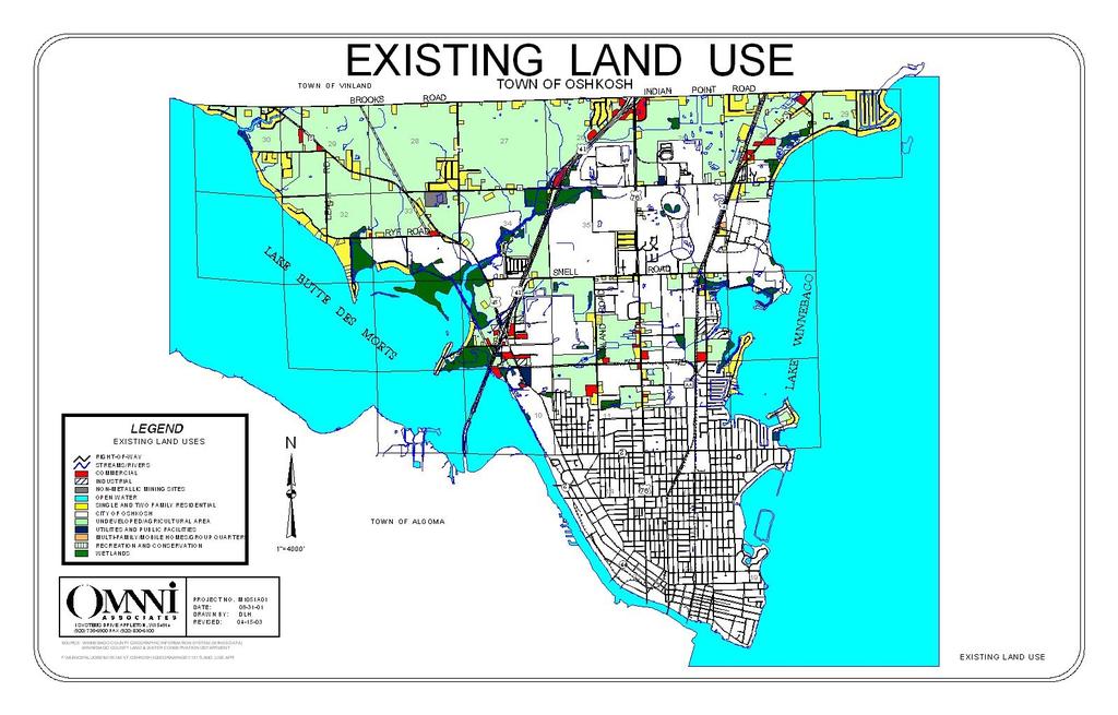
129
130 Existing Land Use Breakdown The table below is a required numerical breakdown of the existing land uses in the town. This table is required by 1999 WI Act 9, Wisconsin s Smart Growth Law. The net density (total number of dwelling units divided by all residential acres) in the Town of Oshkosh is 1.45 dwelling units/acre (1,348 housing units/930.5acres). Land Use Type TABLE EXISTING LAND USE AMOUNT & INTENSIY Amount (in acres) % of Planning Area Single & Two Family Residential % Multiple-Family / Retirement Homes % Agricultural Land / Undeveloped 4, % Conservancy % Wetlands % Parks & Recreation % Industrial % Commercial % Utilities & Community Facilities % Transportation Roads and Railroads % Mining/Quarry Sites % Inland Water Features (Excludes Lake Butte Des Morts and Lake Winnebago) % Zoning Regulations TOTALS 6, % The Town of Oshkosh zoning requirements are established and enforced by Winnebago County. Table 20 provides a summary of the Winnebago County Zoning Ordinance dimension For additional information about zoning ordinance requirements related to permissible uses, landscaping, signage and the like, contact the Winnebago County Zoning Department at (920) or review the ordinance online at requirements, by district, in the Town of Oshkosh. There are 14 different zoning districts found in the Town of Oshkosh. R-1, RURAL RESIDENTIAL NON-SUBDIVIDED DISTRICT The intent of this district is to accommodate scattered home sites in areas where neighborhood and community facilities are of secondary consideration to the location of the home site itself. R-2, SINGLE FAMILY SUBDIVIDED DISTRICT Single-family detached residential development in subdivisions is permitted in this zone. Town of Oshkosh Comprehensive Plan Existing Land Use Chapter
131 R-3, TWO FAMILY RESIDENTIAL DISTRICT This district accommodates medium density residential development with emphasis on two family attached residential uses. R-4, MULTIPLE FAMILY RESIDENTIAL DISTRICT Higher density residential development, including duplexes, apartments, condominiums and the like are permitted in this district. The intent is to provide rental housing while retaining a relatively low overall density pattern. All development in this zone must be connected to public sewer. R-5, PLANNED RESIDENTIAL DISTRICT This district can accommodate condominium and cluster development. A diversity of dwelling types, open space and uses conceived and planned as comprehensive and cohesive projects are permitted in this district. MH-1, MOBILE HOME DISTRICT The intent of this district is to provide standards for mobile homes in a duly recorded and legally maintained subdivision. Sewers are not necessarily required. A-1, AGRICULTURAL BUSINESS DISTRICT This district accommodates large-scale agricultural uses, including, but not limited to: crop farming, beekeeping, dairying, fish farms, forestry, grazing, greenhouses, livestock raising and sod farming. A-2, GENERAL FARMING DISTRICT This district is designed to allow the development of small-scale farming operations, characterized by the mixed crop traditional family farm. All uses permitted in the A-1 district are permitted, along with single and two-family homes, provided homes are accessory to the farming use. B-1, LOCAL SERVICE DISTRICT Provides for individual or small grouping of retail and customer service establishments. These businesses shall be low-traffic generating and shall not exceed 1,500 square feet of area for the principal structure. B-2, COMMUNITY BUSINESS DISTRICT This district accommodates localized commercial markets throughout Winnebago County. The development in this area would be on a much smaller scale than regional commercial operations (i.e. malls). It is the intent of this zoning district to encouraging the grouping of commercial establishments. B-3, HIGHWAY BUSINESS DISTRICT This district is to provide for the special development needs of businesses that have a countywide trade area. The secondary intent of this district is to provide for certain commercial activities that are uniquely oriented toward the service of highway traffic. Town of Oshkosh Comprehensive Plan Existing Land Use Chapter
132 M-2, HEAVY INDUSTRIAL DISTRICT This district accommodates all of the uses permitted in the Light Industrial District, but also permits freight yards, indoor storage warehouses, breweries, and all other manufacturing, assembly or processing. Vehicle body shops and vehicle wholesale and auction centers are also permitted in this district. M-1, LIGHT INDUSTRIAL AND OFFICE DISTRICT This district is designed to accommodate so-called clean industrial neighborhoods and associated office uses. Specifically, general, clerical and professional offices, research and development facilities, wholesale distributors, millwork, light metal fabrication, small manufacturing operations, commercial bakeries, and contractors offices are permitted in this district. P-1, INSTITUTIONAL AND RECREATIONAL PARK DISTRICT This zoning district provides for uses such as cemeteries, funeral homes, hospitals, schools, landfills and parks. The Town of Oshkosh Zoning Map illustrates the existing zoning established under the Winnebago County Zoning Ordinance. This map is provided on the next page. In addition to these specific zoning district requirements, the Winnebago County Zoning Ordinance includes sign regulations, landscape regulations and the shore land zoning overlay requirements. Town of Oshkosh Land Divisions & Subdivision Ordinance Since 1999, the Town of Oshkosh has had its own subdivision ordinance. The purpose of the ordinance is to regulate and control the division of land within the unincorporated areas of the Town of Oshkosh to: Further the orderly layout and use of land; Prevent the overcrowding of land; Lesson the congestion on streets and highways; and Facilitate adequate provision for water, sewage and other public improvements. The ordinance outlines procedures for land division, technical requirements, design standards for plats and certified survey maps, and outlines required improvements (i.e. stormwater detention, public and private sewage, land dedication). The ordinance also provides for sidewalks, if determined by the Town Board to be necessary for safe pedestrian movement, particularly in high traffic areas, near commercial areas, schools, and places of public assembly. The ordinance does not provide requirements for establishing cluster subdivisions or planned unit developments. To obtain a copy of the Town of Oshkosh Subdivision Ordinance, contact the Town Clerk. Town of Oshkosh Comprehensive Plan Existing Land Use Chapter

133
134 DISTRICT MINIMUM AREA TABLE 20 WINNEBAGO COUNTY ZONING DISTRICTS + PUBLIC SEWER REQUIRED FRONT SETBACK R-1, Rural Res. NA No 30 feet R-2, Single Family Subdivided R-3, Two Family R-4, Multiple Family R-5, Planned Residential MH-1, Mobile Home District B-1, Local Service B-2, Community Business B-3, General Business District P-1, Institutional and Rec. A-1, Agri Business A-2, General Farming M-1, Light Industrial M-2, Heavy Industrial NA No 30 feet NA No 30 feet NA Yes 40 feet NA Yes None SIDE SETBACK 7 feet one side 10 feet other 1 feet one side 10 feet other 1 feet one side 10 feet other 15 feet each side 15 feet btwn single- & twofamily; 30 feet for other REAR SETBACK SHORE SETBACK 25 feet 75 feet 25 feet 75 feet 25 feet 75 feet 40 feet 75 feet None Requires Conditional Use Approval. Provisions for minimum setbacks do not apply. 80, ,000 sq feet (unsewered) 40,000-65,000 sq feet (sewered) 130, ,000 sq ft (unsewered) 65, ,000 (sewered) acres (unsewered) 6-10 acres (sewered) No No No 30 feet 30 feet 50 feet 7 feet one side 10 feet other 7 feet one side 10 feet other 7 feet one side; 10 feet other 75 feet 75 feet 25 feet 75 feet 25 feet 75 feet 50 feet 75 feet NA No 75 feet 15 feet 50 feet 75 feet NA No 75 feet 15feet 50 feet 75 feet NA No 75 feet 15feet 50 feet 75 feet NA No 30 feet NA No 30 feet SOURCE: Winnebago County Zoning Department, feet one side; 10 feet other 7 feet one side; 10 feet other 25 feet 75 feet 25 feet 75 feet + Subject to Change. Consult Winnebago County Zoning Ordinance for Current Requirements. Town of Oshkosh Comprehensive Plan Existing Land Use Chapter
135 Trends in Supply, Demand and Price of Land The Town of Oshkosh has a strong desire to carefully regulate the location of new residential development in order to ensure that future growth will not have a negative impact on the town s rural character, interfere with farming operations, or result in significant increases in service needs and costs. Historically, there have been two choices for housing locations in the Town of Oshkosh: In one of the sanitary districts, or On a larger, rural parcel beyond the sanitary districts. RESIDENTIAL DEVELOPMENT Historically, the sanitary districts have been the focus of residential development. Situated along the waterfront areas, the districts include many older waterfront homes that were initially developed as cottages and summer residences. The value of these properties is being realized and many of the seasonal homes have been converted into year-round residences. Likewise, infill development on remaining lakeshore properties has continued. As the more expensive properties with lake frontage have become occupied, new development has started to infill areas across the street from the waterfront and beyond. This trend of increased development, near the waterfront, though not actually on the water, will continue in the future. In other areas of the town, beyond the waterfront, homes are generally situated on larger lots with individual sewer systems and private wells. These homes sites are more affordable than the waterfront properties in the sanitary districts and the land values are comparable to values in nearby towns. However, development of these parcels does require the installation of private wells and septic systems that significantly increase development costs. Most of these rural residences were built along roadsides as farmers and other landowners sought to sell lots for revenue. The result is a string of homes along county and town roads. This pattern is evident on the Existing Land Use Map. To prevent conflicts with adjacent farmland and to maintain contiguous farm fields, the town encourages rural subdivisions that cluster rural development together in one area, rather than allow it to stretch down an entire road or into a larger area. Residents of the town take great pride in their natural environment. New residential development has successfully adapted to the natural environmental limitations. For example, soils limitations have prevented basements in certain areas. Nevertheless, quality residential homes are being built without basements in these areas (i.e. Shangri La Point). FARMING There is a strong desire to retain farmland in the Town of Oshkosh. This priority was clearly expressed in the community survey and during the planning workshops and meetings. However, the state, regional and county farming economy has continued to suffer from a reduction in the number of farmers. Likewise, the number of local farmers has also decreased. This can be attributed to diminished farm product returns and aging farmers seeking retirement. Town of Oshkosh Comprehensive Plan Existing Land Use Chapter
136 As local farmers age, the supply of farmers willing and able to purchase land for farming is diminishing. Unlike the past, when the children of a farmer would takeover the land, children of today s farmers are seeking jobs with 401K and other benefits the farm cannot provide. Nevertheless, farmers wishing to retire need to find ways to raise the money needed to sustain their lifestyle in retirement. This leads to pressure to sell and convert farmland to other more profitable uses for better sale prices. Reported farmland sales values are only $1,440/acre compared to $2,727/acre for farmland sold for development purposes. 1 This trend in land value is not expected to reverse itself. In fact, it will likely only continue to grow in the future creating additional pressure for land development. Preservation of rural character is contingent upon successful efforts to retain farmland. The Implementation Element provides additional detail about strategies to be considered, including: Encouraging landowners to pursue opportunities to partner with land trusts charged with protection of natural areas and farmland; Establish an Agriculture Committee to minimize farmland conflicts through negotiation and open communication; Establishing networks, through the Agriculture Committee to connecting farmers who are considering selling their land property with other farmers who would like to acquire additional property; and Pursue transfer and purchase of development rights program opportunities. COMMERCIAL AND INDUSTRIAL DEVELOPMENT The town s commercial and industrial development sectors are growing steadily. Though still only a fraction of the town s land area, commercial and industrial activities are becoming more common. The town wants additional commercial and industrial development to support the local tax base and provide quality local employment opportunities. New commercial and industrial development is currently locating along USH 41, near the town s northernmost boundary. Commercial development is also occurring along CTH A. Future development is anticipated along STH 45. Commercial and industrial land sold in the town costs less than properties sold in the City given the limited services available. This difference in land value is not expected to change in the future. Town land will continue to be more affordable. Opportunities for Redevelopment Given the town s limited development history, there is not a strong need for redevelopment. Commercial and industrial operations are modern and efficient to meet local needs. The primary opportunity for redevelopment is the aging waterfront cottages that are being converted into year-round residences. Long-term redevelopment is also expected for the quarry in the town. 1 The Program on Agricultural and Technology Studies & The College of Agriculture and Life Sciences, Wisconsin Land Use Research Program, July 1, 1999, based on tax record data from WDNR and Tiger Census Files. Information is available on-line at Town of Oshkosh Comprehensive Plan Existing Land Use Chapter
137 10.0 FUTURE LAND USE Introduction This chapter provides the 10-year and 20-year Future Land Use Maps for the Town of Oshkosh. These maps illustrate the goals, objectives, visions and policies expressed throughout this plan and express the town s overriding desire to maintain its boundaries. Land Use Vision Land use within the Town of Oshkosh is centered around conservation subdivisions and other single-family residences that are surrounded by protected open space, natural areas, and farmland. Commercial and light industrial development is concentrated along the major highway corridors and includes buffers to protect encroachment into residential areas. Large portions of the town have been preserved for a wide variety of landand water-based recreational uses and land conservation. To develop the Future Land Use Maps presented in this chapter a great deal of time and effort over the course of a 2-year planning program and an extensive plan to plan preparation phase facilitated by the UW-Extension was required. The planning process was initiated with a vision development effort and review of historic population characteristics. This information is described in Chapters 2 and 3. From there, the Planning Advisory Committee studied current conditions and future needs related to housing (Chapter 4), transportation (Chapter 5), utilities and community facilities (Chapter 6), and economic development (Chapter 8). The Planning Advisory Committee also examined the natural environment and agricultural considerations in Chapter 7. Finally, existing land use patterns and regulations were considered in the previous chapter. Desired Development COMMUNITY SURVEY RESULTS In the community survey, residents were adamant about the need to protect farmland and the rural character in the Town of Oshkosh. When asked specifically about which type of land uses should be encouraged or discouraged, single family housing (81%), agriculture (70%), and recreational uses (57%) were the most supported. More people discouraged than encouraged: light industrial, restaurant, convenience store, mini-storage, strip malls, multiple family housing and heavy industrial development. Town of Oshkosh Comprehensive Plan - Future Land Use Chapter
138 When asked where new commercial development, if it were to occur, should be located in the Town of Oshkosh, residents most strongly favored the USH 45 and USH 41 corridors. Secondary commercial development areas were indicated along CTH A and STH 110. COGNITIVE MAPPING Another tool used to determine desired future development was cognitive mapping. Cognitive mapping is a process whereby individuals have the opportunity to develop their own future land use maps of the town, based on their ideas, perceptions, experiences and beliefs. These maps were discussed in small groups to develop group consensus maps. Chapter 2 describes the cognitive mapping process in detail. A copy of the group Majority Opinion Map (Consensus Map) is provided in an appendix to this plan. Generally, the individual committee member maps expressed a desire to accommodate future residential and park development anywhere in the town. Commercial development was desired along USH 45 and USH 41. SEWER SERVICE AREA PLAN RECOMMENDATIONS The sewer service area plans developed by the East Central Wisconsin Regional Plan Commission were an important tool for understanding development limitations and expectations. Additional information about these plans and their recommendations is provided in the Utilities and Community Facilities Element (Chapter 6). Annexation At this time in Wisconsin, cities cannot instigate annexations. Town landowners have to petition for annexation; then cities determine whether or not they are willing to annex those parcels. To better understand why annexations are occurring, the town should study why residents decide to petition for annexation: Do residents want services the town is unable to provide? Does annexation increase the marketability and value of their property? Is the annexing municipality more willing than the town to address their concerns? What other issues are involved? Once the issues have been identified, the town needs to determine what measures it can, and is willing, to take to address those issues. The 1993 City of Oshkosh Comprehensive Plan indicates that annexation is a required tool to extend the city limits to accommodate new growth and development. Furthermore, the city s plan indicates that incorporation of lands identified as high Town of Oshkosh Comprehensive Plan - Future Land Use Chapter
139 growth areas is encouraged. The plan indicates that the areas east of USH 41 in the Town of Oshkosh are considered high growth areas. West of USH 41, the 1993 City of Oshkosh Comprehensive Plan and this plan are virtually identical with respect to growth and preservation. The Town of Oshkosh is very concerned about continued annexations. The town wants to maintain its boundaries to retain its community identity and prevent further fragmentation. The town firmly believes that the City of Oshkosh has ample lands within its current boundaries to develop in the future. Furthermore, the town takes great pride in it ability to provide quality residential neighborhoods. As desirable, the town plans to continue to coordinate with neighboring towns to establish a boundary agreement with the city to better anticipate any future annexations, plan accordingly, and minimize their impact on the town. Incorporation 1 DEFINITION AND CONSIDERATIONS Municipal incorporation - the process of creating new villages and cities from town territory - is regulated by sections through of the Wisconsin Statutes. The Department of Administration (DOA) is the administrative agency charged with facilitating the incorporation process. The DOA determines the ability of the territory petitioning for incorporation to meet certain minimum statutory standards and advises the circuit court to either accept or reject the incorporation petition. Deciding whether or not to attempt incorporation is a decision to be collectively undertaken and financed by citizens residing in the territory under consideration. Citizens need to consider not only whether or not the standards to be initially reviewed by the circuit court can be met, but also whether the territory, level of proposed services and budget, and other relevant issues meet the more difficult statutory standards required to be evaluated by the Department of Administration. REQUIREMENTS FOR INCORPORATION Characteristics of the Territory. The entire territory of the proposed village or city shall be reasonably homogenous and compact, taking into consideration natural boundaries, natural drainage basins, soil conditions, present and potential transportation facilities, previous political boundaries, boundaries of school districts, shopping and social customs. An isolated municipality shall have a reasonably developed community center, including some or all of such features as retail stores, churches, post office, telecommunications exchange and similar centers of activity. 1 Text from this section taken from the Wisconsin Department of Administration Web Site, Town of Oshkosh Comprehensive Plan - Future Land Use Chapter
140 Territory Beyond the Core. The territory beyond the most densely populated one-half square mile specified in s (1) or the most densely populated square mile specified in s (2) shall have an average of more than 30 housing units per quarter section or an assessed value, as defined in s (1)(a) for real estate purposes, more than 25% of which is attributable to existing or potential mercantile, manufacturing or public utility uses. The territory beyond the most densely populated square mile as specified in s (3) or (4) shall have the potential for residential or other urban land use development on a substantial scale within the next 3 years. The Department may waive these requirements to the extent that water, terrain or geography prevents such development. Tax Revenue. The present and potential sources of future tax revenue must appear sufficient to defray the anticipated cost of governmental services at a local tax rate that compares favorably with the tax rate in a similar area for the same level of services. Level of Services. The level of governmental services desired or needed by the residents of the territory compared to the level of services offered by the proposed village or city is also considered. Impact on the Remainder of the Town. The impact, financial and otherwise, upon the remainder of the town from which the territory is to be incorporated is considered in the application. Impact on the Metropolitan Community. The effect upon the future rendering of governmental services both inside the territory proposed for incorporation and elsewhere within the metropolitan community is a factor to determine incorporation. There shall be an express finding that the proposed incorporation will not substantially hinder the solution of governmental problems affecting the metropolitan community. INCORPORATION POTENTIAL FOR THE TOWN OF OSHKOSH Given the strict requirements for incorporation, it is highly unlikely that the Town of Oshkosh would seek to incorporate. The town does not believe incorporation is required to maintain its high quality residential, commercial, and industrial development areas. Cost of Development 2 Residential development is growing in the Town of Oshkosh. As such, it continues to provide an increasing share of the local tax base. Therefore, residential development provides economic development gains for the town. However, to a much greater degree than commercial and agricultural development, housing requires extensive services to accommodate resident needs. These services include: schools, parks, sanitary sewer, 2 Additional Information about the Town of Dunn Community Services Study is available on-line at Town of Oshkosh Comprehensive Plan - Future Land Use Chapter

141 public safety, roads and associated maintenance (including snowplowing), and other amenities. It is critical that future residential development services needs not offset gains in the local tax base. As an example, in 1994, the Town of Dunn 3 in Dane County, WI conducted a study to understand the tax implications of development. The study showed for every dollar of tax revenue collected from residential development, $1.06 was required in services for residential users. (Any service costs greater than $1.00 result in a net loss for the town.) Conversely, for every dollar collected from a commercial development, $0.29 was required for services. Therefore, commercial uses bring additional tax dollars into the community. For every dollar collected from farmers, as little as $0.18 was required in services. It is important to ensure that local residential tax dollars cover the costs to provide needed services. The Town of Oshkosh supports additional residential development opportunities, but the town does not want to see new residential development significantly increase town operating and service costs for all existing homeowners and taxpayers. Therefore, the town supports new residential development paying a fair and proportionate share of service costs. Community Design Considerations Ensuring that developed and natural areas of the Town of Oshkosh are attractive and well-maintained is an important priority. To that end, the town supports the continued enforcement of zoning regulations, including sign ordinances. Likewise, the Town of Oshkosh supports the use of a detailed site plan review process, including lighting, sidewalk, building material and sign proposals, to ensure that new development is compatible with surrounding land uses and the visions, goals, objectives and policies expressed in this plan. WATERFRONT DEVELOPMENT Development along the waterfront has been a tradition in the town. The town takes great pride in these attractive residential development areas and the sense of community identity residents of these areas share. To ensure the waterfront remains an attractive part of the community, the town supports efforts to maintain scenic views of the waterfront, access to the waterways, and natural wildlife habitat along the shorelines. The town will preserve wetlands, woodlands and floodplain areas along the shores of Lake Winnebago and Lake Butte des Morts. Town of Oshkosh Comprehensive Plan - Future Land Use Chapter
142 STORMWATER MANAGEMENT Given that the Town of Oshkosh has been identified as a community subject to EPA Phase II Stormwater Regulations and Permitting, it is more critical than ever that considerations related to the stormwater impact of development be considered when future development is proposed. Additional information about these Phase II requirements is provided in the Utilities and Community Facilities Element (Chapter 6). There are increasing concerns about the impacts of stormwater runoff on the quality of receiving water resources like Slough Creek, Lake Winnebago and Lake Butte des Morts. Of significant concern is the impact of additional impervious surface area in the watershed. As development occurs, additional streets, parking areas and buildings are constructed which increase impervious surface. Within a watershed, as impervious surface area increases, area streams are adversely impacted. In fact, relatively low levels of impervious coverage can have a significant impact on the quality of area streams and lakes. To mitigate these impacts, the town will pursue: Watershed Planning. All watershed-planning activities in the Town of Oshkosh will be coordinated with the Winnebago County Land Conservation Department to identify critical habitats, aquatic corridors and water pollution areas. Land Conservation Techniques. Land conservation techniques include: cluster and conservation subdivisions, setbacks, buffers, land acquisition, and following the development patterns outlined on the Future Land Use Map. Aquatic Buffers. Aquatic buffers are natural areas on either side of area streams to buffer against runoff. The Winnebago County Shore land Zoning Ordinance requires a permit for any filling or grading activity within 300 of any navigable stream as a minimum to protect the stream from harmful impacts. Site Design Techniques. Effective site design techniques will encourage the use of natural landscaping, limit impervious surface, enforce setbacks and buffers, and protect natural resources. Stormwater Best Management Practices (BMP). Stormwater best management practices seek to reduce storm water pollutant loads, maintain ground water recharge and quality, protect stream channels and safely maintain the 100-year floodplain. Successful BMP s include ponds, wetlands, infiltration, filtering systems and open drainage channels. The county subdivision ordinance requires use of BMPs. Erosion and Sediment Control. Typically, erosion and sediment control requirements affect construction sites and farming operations. To be effective, erosion and sediment control measures need to extend beyond these two situations. Probably one of the most effective techniques is to reduce the time that soil is exposed. As with the other mitigation techniques outlined in this subsection, education will be critical to success. Town of Oshkosh Comprehensive Plan - Future Land Use Chapter
143 In accordance with the EPA s Phase II Stormwater Permitting Requirements (See Chapter 6 for additional information), the town will enhance site planning efforts to address stormwater and develop education program for residents and developers. OUTDOOR LIGHTING For additional information about the Dark Sky Preservation, visit their web site at: In recent years a movement has spread across the country related to the outdoor lighting. At the forefront of these efforts is the Dark Sky Preservation. This organization s mission is to ensure that the night sky is visible by eliminating intrusive lighting. The Town of Oshkosh believes that its rural character includes the dark skies overhead which make it possible to enjoy the stars. To that end, during its own site plan review and through coordination with the county and neighboring communities, the Town of Oshkosh will seek to promote environmentally friendly lighting choices that: Keeping glare to a minimum; Discourage the use of direct uplighting in any application; Put outdoor lighting only where it is needed and when it is needed; Use alternatives to constant dusk-to-dawn lighting whenever possible; and Eliminate light trespassing on neighboring properties and roadways. OUTDOOR ADVERTISING (BILLBOARDS) Several highway corridors in the town offer opportunities for billboard advertising. To preserve and enhance the scenic character of the town, billboard signs are prohibited. Billboards distract from the rural scenic quality of these highway corridors. The town believes that preservation of natural beauty, including open views of woodlands, wetlands and farmlands from roadways, is important to protect the quality of life and rural community identity. CONSERVATION SUBDIVISIONS The Town of Oshkosh believes that conservation subdivisions are a viable development technique to accommodate development demands while protecting valued natural habitat areas and farmland. For additional information about conservation subdivisions refer to the Agricultural, Natural & Cultural Resources Element (Chapter 7). The most desirable locations for conservation subdivisions in the Town of Oshkosh are west of USH 45 and as a buffer between farming areas, wildlife habitats, and important wetland/floodplain areas. Conservation subdivisions are not desired in the sanitary districts. Town of Oshkosh Comprehensive Plan - Future Land Use Chapter


144 PUBLIC LAKE ACCESS The Town of Oshkosh takes great pride in its location between Lake Winnebago and Lake Butte Des Morts. These two lakes play a critical role in defining the character of the community. Moreover, they provide numerous scenic, wildlife, natural, recreational and economic benefits to the town and region. For example, annually the lakes host more than 70 fishing tournaments. The Sunset Bay area along Lake Butte Des Morts is an important fish spawning area that supports fishing/tourism on the lakes. Of some concern is the issue of public access to the lakes. Much of the shoreland areas in the town are privately owned. Residents with waterfront property do not want people trespassing on their land. This issue is compounded at key destination points like the WIOUWASH Trail and Sunset Bay. Fortunately, some areas of the lakeshore are owned by the WDNR and Winnebago County. However, these properties cannot accommodate all demand for public access to the lakes. The town understands the need to provide additional year-round public access to the lakes. To that end, the town has identified a potential public access point along the Lake Butte Des More north shore near Sunset Bay on the Future Land Use Maps. In order for this site to be improved for public access (i.e. parking, boat launch, lighting, signage, etc.), grant funds and donations would need to be provided by Winnebago County and/or the WDNR. MANAGED ROADWAY ACCESS Another tool available to maintain rural roadside character, particularly through the town, is strict control over roadway access. Roadway access refers to the number of points of ingress and egress from a roadway. Managing roadway access points helps to promote safe and efficient travel and minimize disruptive and potentially hazardous traffic conflicts. Managed roadway access involves minimizing the number of driveways along a roadway and establishing standards for driveway spacing. Rather than promoting driveway after driveway along rural roadways and highways, shared driveways are encouraged (see diagram). This approach has the added benefit of limiting impervious surface and its associated impacts Town of Oshkosh Comprehensive Plan - Future Land Use Chapter
145 on groundwater quality. Likewise, driveway spacing is determined based on the posted speed limit, not property lines (See box at right). The Winnebago County Planning Department and WisDOT regulate current standards for roadway access. Coordination with these agencies is important to ensure that rural character is preserved. RURAL DEVELOPMENT Given the abundance of rural areas (i.e. woodlands, farm fields and other undeveloped areas) in the Town of Oshkosh, it is necessary to address the question of rural development. Posted Speed Minimum Limit (MPH) Driveway Spacing (in Feet) Source: E. Humstone & J. Campoli, Access Management: A Guide for Roadway Corridors, Planning Commissioners Journal, Winter The Future Land Use Maps indicate areas where farmland should be protected and remain in the future. If a farmer, or large landowner, would like to develop their property after this plan has been adopted, the farmer/landowner, must: Work with the Plan Commission to identify areas of his or her property to be protected from development; Consider ways to develop conservation and cluster subdivisions to minimize the impact the proposed rural development will have on the rural character, natural areas, and wildlife habitat; Give special consideration to aquatic buffers and landscape screening along town and county roads adjacent to the development to protect the rural views after development is complete; and Develop a stormwater management plan that provides for innovative and best management practices for managing stormwater runoff. To more clearly define standards for rural development, an objective has been added to this section for the Town of Oshkosh to coordinate with Winnebago County to establish an overlay zone defining specific conditions, in accordance with the ideas described above, to protect rural character. COMM 83 Areas beyond the sanitary districts, proposed for residential development, will be required to demonstrate their ability to provide adequate sewer service. The Town of Oshkosh supports the use of innovative waste treatment systems permissible under the COMM 83 legislation (refer to the Agricultural, Natural & Cultural Resources Element for Additional Information). Specifically, the town supports the installation of individual systems, mounds, and other sewage treatment methods to meet rural residential sanitary needs in the future. The town (and other officials) will review any proposed treatment system to determine effectiveness in the proposed environment. Town of Oshkosh Comprehensive Plan - Future Land Use Chapter
146 QUARRY SITES The Town of Oshkosh does not support additional non-metallic mining operations in the town. It is feared that additional quarries will have a negative impact on the quality of the local surface and groundwater. Moreover, quarry operations are incompatible with desired the rural, residential character of the Town of Oshkosh. When the single existing quarry operation is exhausted, the town supports its reclamation in accordance with its approved reclamation plan. ENVIRONMENTAL CORRIDORS The Town of Oshkosh supports the protection of environmental corridors along local streams and creeks. Likewise, the town firmly supports the protection of its wetland areas. The town will work with Winnebago County to ensure that local shoreland and wetland regulations are enforced to maintain the town s environmental corridors. Environmental corridor efforts will be also closely coordinated with stormwater management efforts, particularly along Slough Creek City of Oshkosh Comprehensive Plan Objectives The 1993 City of Oshkosh Comprehensive Plan was reviewed when developing the Town of Oshkosh Future Land Use Maps. It was important to understand the city s objectives in the context of the town s future planning goals. The city s plan states that as the only municipality in the area, it has its own full-time police and fire protection, centralized water system, planned industrial development areas, and recreation facilities. The plan goes on to say that these amenities are necessary to provide a quality of living for residents. The Town of Oshkosh firmly believes that it can achieve the same, if not a better, quality of living for residents who remain in the town. Benefiting from competitive private and public contracts, the Town of Oshkosh is able to ensure that residents have access to needed amenities, including police and fire protection. Likewise, provisions for water and sewer service are achieved through individual private well and septic systems. The town also encourages residents to utilize innovate waste treatments systems permissible through COMM 83. The town manages to provide a quality living environment, while maintaining a comparatively low tax rate with minimal government interference. These advantages make town living very attractive. How Were the Town s Future Land Use Maps Developed? The Future Land Use Maps were developed using a very specific process: 1. Natural resource areas were identified to understand development limitations Town of Oshkosh Comprehensive Plan - Future Land Use Chapter
147 2. Future population and household projections, in conjunction with zoning requirements, were examined to understand the extent of future residential development needed in the town. 3. Utility and community facility capacities were reviewed to ensure new development would be adequately serviced. 4. Existing development plans were incorporated into the plan maps. 5. Planned and anticipated road and trail network changes were incorporated into the plan maps. 6. The results of the community survey and cognitive mapping exercise were reviewed to emphasize resident desires and expectations. 7. The 1997 Town of Oshkosh Land Use Plan developed by the ECWRPC, the 1993 City of Oshkosh Comprehensive Plan, and the Winnebago County Zoning Ordinance were referenced to understand past planning objectives. The result of this process is the detailed set of Future Land Use Maps presented at the end of this chapter. How Are the Town s Future Land Use Maps to be Used? The Future Land Use Maps are a planning tool for the Town of Oshkosh. In accordance with the Smart Growth Law (Wis. Stats ), they should be used to guide the following actions: Municipal Incorporation Annexation Cooperative Boundary Agreements Official Mapping Local Subdivision Regulation Zoning Transportation Improvements Agricultural Preservation Plans Impact Fee Ordinances Land acquisition for recreational lands and parks Any other ordinance, plan or regulation of a local government that relates to land use. Town appointed and elected officials should use the plan maps as a guide for making future land use decisions. Developers and residents should understand the plan maps are intended to direct development to certain areas. It is important to remember that a plan is not a static document. It must evolve to reflect current conditions. If not regularly reviewed and amended, it will become ineffective. Applications for rezoning and development that are inconsistent with the plan and maps must still be considered. In some situations, it may be desirable to amend the plan (and maps) to accommodate a compatible, but previously unplanned use. Likewise, a change in county or regional policy, technological changes, or environmental changes may also impact the plan. Town of Oshkosh Comprehensive Plan - Future Land Use Chapter
148 Any change to the plan (including the plan maps) must be considered in the context of all nine required plan elements, including the visions, goals and policies expressed in this document. If an amendment is to be approved, the process must include a formal public hearing and distribution per the requirements of the Wisconsin Smart Growth Law. Any amendment must be recommended by the Plan Commission and approved by the Town Board before development is permitted. Town of Oshkosh Future Land Use Maps Provided at the conclusion of this chapter is a 10-Year and 20-Year Future Land Use Maps for the Town of Oshkosh. These maps illustrate the anticipated amount, location, and intensity of new development. The areas outlined for future residential development exceed the areas needed for new development, based solely on the population projections. Additional areas were added to provide choices for residential development so as to prevent the inflation of land values. Likewise, by outlining additional areas, the longevity of the plan is further ensured. The Town of Oshkosh Future Land Use Maps were built from the Existing Land Use Map. Therefore, existing land use patterns and conditions are the foundation of the plan - - the beginning point from which to build the future. Areas that are not proposed for future development are represented by their existing land use in order to promote stability in the Town of Oshkosh. The Future Land Use Maps designate specific areas for future residential, commercial and industrial development to be developed in accordance the requirements stipulated in the Winnebago County Zoning Ordinance and any applicable local zoning code. This map anticipates that the sanitary district boundaries will remain approximately the same over the 20-year planning period. Table 21 provides a detailed breakdown of projected future development, in five-year increments, in the Town of Oshkosh. To implement this plan, the Town of Oshkosh Plan Commission will seek to: Direct development to areas identified on the Future Land Use Maps Minimize residential development lining rural road frontages Consider potential cluster or conservation subdivisions in the northwestern areas of the town, as a buffer adjacent to wetland and woodland habitat areas, and as a buffer to adjacent farmland and rural areas. As with any long-term planning document, as proposals are presented, amendments may be necessary to reflect market forces that shift land use patterns. Town of Oshkosh Comprehensive Plan - Future Land Use Chapter
149 Land Use Type TABLE YEAR PROJECTIONS FOR FUTURE LAND USE 2005 (acres) 2010 (acres) 2015 (acres) 2020 (acres) Single Family Residential Conservation-Based Residential 950 1,241 1,241 1,241 Commercial Commercial / Light Industrial Mix Duplex / Multi Family Mix Duplex / Single Family Mix Recreation & Conservation Farmland / Rural Residential 3,366 2,419 2,308 2,198 Industrial Wetlands Utilities & Community Facilities Transportation Roads & Railroads Inland Water Features (Excludes Lake Butte Des Morts & Winnebago) 48 TOTALS 6,569 6,569 6,569 6,569 NOTE: Acres have been rounded to nearest whole figure. Figures are approximations based on Future Land Use Maps. There are several types of land uses shown on the Future Land Use Maps. What follows is a general description of each category. SINGLE FAMILY RESIDENTIAL Single family residential development, in subdivisions and on individual lots, is encouraged in areas shown in yellow on the Future Land Use Maps. CONSERVATION-BASED RESIDENTIAL Properties included in this category include farmland, woodland, shoreland, wildlife habitat and other natural areas the town would like to preserve. Therefore, development in these areas should be sensitive to these amenties. Conservation-based subdivision approaches are encouraged. COMMERCIAL Commercial areas would include development permissible through the following districts in the Winnebago County Zoning Ordinance: B-1 Local Services, B-2 Community Business, and B-3 Highway Business. Town of Oshkosh Comprehensive Plan - Future Land Use Chapter
150 COMMERCIAL/LIGHT INDUSTRIAL MIX Areas identified in this category will accommodate a blend of commercial (retail, office, service) establishments and some light industrial uses currently permitted through the M- 1, Zoning District, of the Winnebago County Zoning Ordinance. All development in must be attractively landscaped and buffered from other uses. DUPLEX/MULTIPLE FAMILY These areas are intended to accommodate duplexes, three-plexes, four-plexes, as well as, condominium, town home and apartment units. DUPLEX/SINGLE FAMILY These areas are to accommodate a harmonious blend of duplex and single family development. In many instances, it is anticipated that the duplex development would be located adjacent to county and town roads and the single family residential development would be situated further inland on subdivision streets. RECREATION AND CONSERVATION Developed parks, as well as undeveloped protected lands and natural areas are included in this category. Several of the areas shown are permanently protected open spaces deeded to the town. FARMLAND AND RURAL RESIDENTIAL This area is designed to primarily accommodate continued farming operations in the Town of Oshkosh. Limited, single family residential development is also permitted on individual lots (not in subdivisions) in these areas. The R-1 district of the Winnebago County Zoning Ordinance would be used to permit said residential development. INDUSTRIAL These areas would include uses permitted in the M-1 and M-2 Zoning Districts of the Winnebago County Zoning Ordinance. Specific uses would include manufacturing, assembly, production and other industrial facilities. Coordination with Other Required Plan Elements The Future Land Use Maps presented in this chapter represent the culmination of desires, limitations, and expectations expressed in each of the other elements. What follows is a brief description of how these Future Land Use Maps were coordinated with other elements of the plan. Town of Oshkosh Comprehensive Plan - Future Land Use Chapter
151 ISSUES & OPPORTUNITIES Included in this element are population trends and projections through This information was critical for understanding how much land was needed for additional development. Likewise, this element provided the visions for the future related to each of the nine required plan elements. The visions express desired conditions in 20 years. HOUSING The expectations and desires related to housing development are reflected by the location and amount of land designated for residential development. TRANSPORTATION All development outlined in the Future Land Use Maps was considered in relation to existing and proposed road network capacity to support addition development. Likewise, accommodations for trails have also been carefully considered as part of the Future Land Use Maps. AGRICULTURAL, NATURAL & CULTURAL RESOURCES The Town of Oshkosh has a significant supply of natural resources including shorelines, woodlands, floodplains and wetlands. The desire to protect these areas from development was a primary objective in developing the Future Land Use Maps. Likewise, since farmland preservation was also an important objective, efforts have been made throughout this chapter and on the Future Land Use Maps to protect farmland areas. UTILITIES AND COMMUNITY FACILITIES One factor that will influence the location and pattern of development is the highway accessibility and visibility. For this reason, non-residential development is encouraged along major highway corridors and residential development expands from existing residential areas. INTERGOVERNMENTAL COOPERATION The town made many special efforts to facilitate intergovernmental coordination. First, the town invited a representative from the City of Oshkosh to attend all Planning Advisory Committee Meetings to provide feedback. Moreover, the town utilized data and other resources available from the county, regional planning agency, DNR, DOT and other stakeholders. Likewise, the town sought comments from all neighboring communities and the aforementioned agencies to help ensure that this Comprehensive Plan, including the Future Land Use Maps, are as compatible as possible with other area plans. Town of Oshkosh Comprehensive Plan - Future Land Use Chapter
152 ECONOMIC DEVELOPMENT The town supports additional economic development, particularly near its highway corridors. Accordingly, new areas for commercial and industrial development are shown in these areas. Goals and Objectives The Town of Oshkosh anticipates that it will grow over the next 20 years. To ensure that this development will not destroy the rural character of the area, negatively impact the natural environment, or create undue congestion on town, county and state roads, the Town of Oshkosh, will pursue the following goals and objectives. OVERALL GOAL Maintain the rural atmosphere in the Town of Oshkosh and the characteristics the community values (see chapter 1). OBJECTIVES 1. Enforce town and county zoning and subdivision ordinance requirements. a. Coordinate with Winnebago County to prohibit billboards along town, county and state highway corridors in the Town of Oshkosh. b. Coordinate with Winnebago County to establish overlay requirements related to rural development (i.e. landscape buffers, managed roadway access, outdoor lighting, billboards, etc.) 2. Permit the development of cluster or conservation subdivisions to maintain open spaces and scenic vistas within the town and create a buffer between residential and agricultural development. a. Amend the town subdivision ordinance to address requirements for conservation subdivision development. b. Delineate specific areas suitable for conservation subdivisions and cluster developments based on primary and secondary conservation areas. Include this map in the revised subdivision ordinance. c. Coordinate with the Winnebago County Planning Department to establish overlay requirements for conservation considerations in rural areas of the Town of Oshkosh. These requirements should establish a minimum percentage of areas to be preserved in every development, landscape buffers/screens along roads, driveway management and desired areas for protection (i.e. steep slopes, wooded areas, wetlands, floodplains, meadows, etc.). 3. Coordinate with the local sanitary districts, electric, natural gas and other utility providers to ensure that adequate utilities will be made available for cost effective future growth and development in the town. 4. Work with the UW-Extension, Winnebago County Zoning Department, and other professional experts to develop and enforce a site plan/design review ordinance to present a positive image of the community and provide guidelines for developers related to the appearance of commercial and industrial development in the town. 5. Coordinate with the WDNR and Winnebago County to provide additional public access to Lake Butte Des Morts and Lake Winnebago. 6. Study the impacts of annexation on the Town of Oshkosh. a. Survey residents to understand attitudes and reasons for annexation. Town of Oshkosh Comprehensive Plan - Future Land Use Chapter
153 b. Develop material to inform residential about the benefits of town landownership. Distribute this information through a town newsletter, annual meeting and town internet web page. c. As desirable, continue to coordinate with towns in region to establish a boundary agreement with the City of Oshkosh. 7. Comply with all EPA Phase II Stormwater Permit Requirements. This effort will require coordination with Winnebago County and neighboring communities. 8. If an opportunity arises to get out of county zoning, the Town of Oshkosh will consider the option and develop a town zoning ordinance. POLICY To maintain its community identify, promote its rural values and preserve its tax base, the Town of Oshkosh supports efforts to maintain its boundaries and eliminate future annexations. Town of Oshkosh Comprehensive Plan - Future Land Use Chapter
154
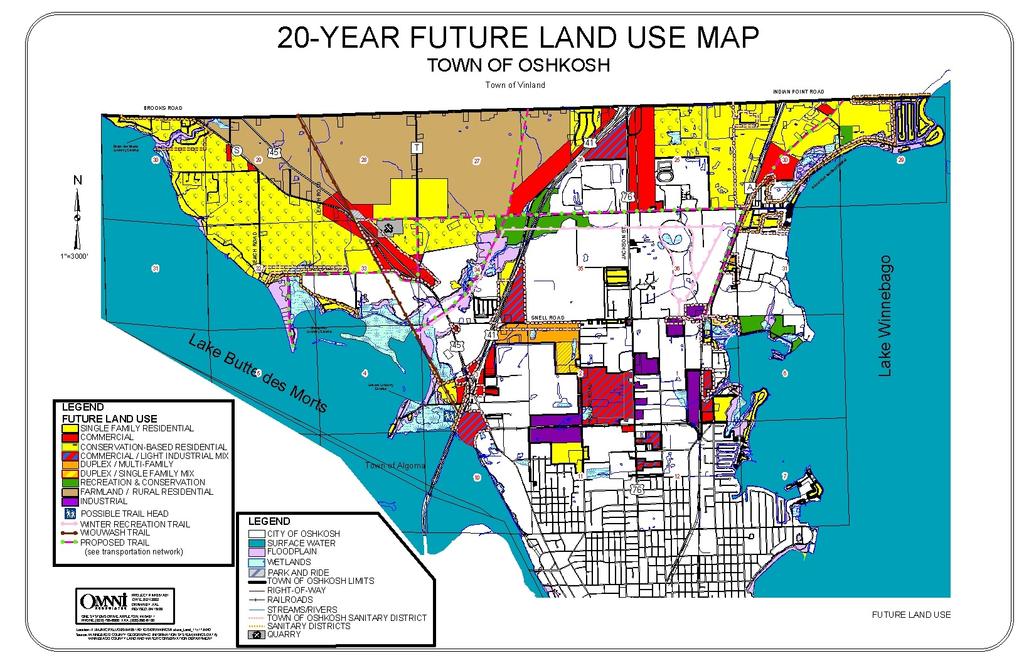
155
156 11.0 INTERGOVERNMENTAL COOPERATION Introduction The Town of Oshkosh s relationship with neighboring municipalities, school districts, sanitary districts, state agencies and Winnebago County can significantly impact town residents in terms of the provision of services, and the siting of public facilities. An examination of these relationships and the identification of potential conflicts will help the town address these situations in a productive manner. Intergovernmental Cooperation Vision In twenty years, the City and Town of Oshkosh work cooperatively to provide residents with a wide variety of cost-efficient, non-duplicative services for the betterment of both communities. Annexation is planned, based on service demands, and coordinated in a fashion to ensure that both communities have preserved their community identities, while providing a unique blend of desired commercial, industrial and residential development. School district development is coordinated with the town to ensure that the location, size, and nature of school facilities will not result in additional pressure for annexation, residential development, or the provision of costly services. Town leaders keep residents informed on all matters pertinent to town operations and land development issues and pursue opportunities to provide coordinated, cost-effective services with neighboring governments. Governmental Units and Relationships to the Town of Oshkosh The Town of Oshkosh shares boarders with the Town of Vinland and the City of Oshkosh. In addition, the town must also coordinate with: Island View Sanitary District Butte des Morts Consolidated Sunset Point Sanitary District Sanitary District Edgewood-Shangri-La Sanitary Oshkosh School District District Winneconne School District Wisconsin Department of Transportation (WisDOT) Town of Oshkosh Comprehensive Plan - Intergovernmental Cooperation Chapter
157 Wisconsin Department of Natural Resources (WDNR) Wisconsin Department of Agriculture, Trade and Consumer Protection (DATCP) East Central Wisconsin Regional Planning Commission (ECWRPC) ADJACENT GOVERNMENTAL UNITS Town of Vinland City of Oshkosh The town s relationship with the Town of Vinland can be characterized as one of mutual respect and compatibility from a land use and political standpoint. Towns cannot annex land from one another. Therefore, the borders between the Town of Oshkosh and the Town of Vinland are fixed and boundary disputes are non-existent. The towns share a common rural character. Each town has its own public service programs (i.e. road maintenance and construction, etc.). However, as mutually beneficial opportunities for shared service contracts arise, the Town of Oshkosh and Vinland (as well as other nearby communities) are open to considering options. The City of Oshkosh, having the ability to accept annexation proposals, sometimes creates a strain on intergovernmental relations. This was particularly true during more aggressive annexation campaigns of the past. To ensure that residents are fully informed about the impacts of annexation, this plan calls for the town to educate residents about annexation and study the reasons why annexations occur. Regardless of annexation disputes, the town and city consider intergovernmental cooperation and coordination important. Evidence of this can be seen in the coordination efforts between the City and Town of Oshkosh during the development of this plan. The town s proximity to the City of Oshkosh does provide several advantages. Specifically, many high quality services, such as health care, recreation facilities, senior housing, and library services are available to town residents due to their proximity to the City of Oshkosh. SCHOOL DISTRICTS Oshkosh Area School District Winneconne School District As discussed in Utilities and Community Facilities Element Chapter, the Town of Oshkosh is served by two school districts. The town s relationship with the local school districts can be characterized as cooperative. While from time to time the districts may propose new facilities and improvement the town does not support, the town does appreciate the quality service provided by the school districts. Regular and open communication is critical to ensure that this cooperative relationship will continue and be strengthened as growth occurs. Town of Oshkosh Comprehensive Plan - Intergovernmental Cooperation Chapter
158 SANITARY DISTRICTS Island View Sanitary District Sunset Point Sanitary District Edgewood Shangri-La Sanitary District Butte des Morts Consolidated Sanitary District Oshkosh Sanitary District There are (5) sanitary districts serving portions of the Town of Oshkosh. The town enjoys a positive relationship with the local sanitary districts. The (4) Town Districts purchase from the City of Oshkosh treatment of waste water per an agreement to limit the expansion of said districts. No major expansion of the treatment facilities is anticipated in the near future. While the Town of Oshkosh does not believe that future residential development must connect to municipal sanitary service, continued cooperation between the town and the four sanitary districts is important. COUNTY AND REGIONAL GOVERNMENT UNITS Winnebago County East Central Wisconsin Regional Planning Commission (ECWRPC) The Town of Oshkosh is located in Winnebago County. The county has some jurisdiction within the town. In particular, Winnebago County has jurisdiction over land divisions, on-site sanitary systems, and zoning (including shoreland-wetland and floodplain areas). Winnebago County also maintains many county roads. In those areas where Winnebago County has jurisdiction in the town, the county attempts to get input from the town before making decisions affecting the town. Likewise, the town has attempted to maintain communication with Winnebago County by providing recommendations. The county s jurisdiction has at times created conflict with the town. Future cooperation will be especially important as it relates to: Zoning as a tool to implement this plan Stormwater management Coordination with the Winnebago County Comprehensive Plan With respect to zoning, this plan highlights several strategies the Town of Oshkosh is interested in pursuing to improve the effectiveness of zoning regulations in the town. Specifically, in the Future Land Use Chapter, a discussion is provided with respect to the potential for developing a rural overlay zone. The town expects that the county will fully consider recommendations provided by the town in this plan. Likewise, the town expects the county to understand that the Future Land Use Maps provide a general For additional information about town recommendations and use of this Comprehensive Plan, refer to the Future Land Use Chapter and Implementation Element Chapter. pattern for development. If for example, a single-family home is requested in the Rural Development Area, this action is considered consistent with the Future Land Use Maps and does not require an amendment to the plan or maps. Town of Oshkosh Comprehensive Plan - Intergovernmental Cooperation Chapter

159 Furthermore, the town would like to coordinate with the City of Oshkosh and Winnebago County to consider special zoning requirements to provide greater consistency between the City and County Zoning Ordinances for the isolated town properties located south of Snell Road. During the intergovernmental process, the City of Oshkosh expressed some concern that the Winnebago County and City of Oshkosh Zoning Ordinances are significantly different with respect to setback, landscaping, lighting and signage. For these town properties, nearly, if not completely, surrounded by the City of Oshkosh, development can look very different from neighboring city parcels. To provide a more consistent pattern on the landscape, it is desirable to consider special zoning requirements for these parcels. Similarly, the City of Oshkosh, through the intergovernmental process, expressed some concern about the density of residential development proposed on the DRAFT Future Land Use Maps. Specifically, the city was concerned that lower density residential development permitted in the town (under county zoning) in areas adjacent to the city, will hamper the city s growth efforts. To address this concern, the Town of Oshkosh Planning Advisory Committee decided to review the development pattern and density proposed on the DRAFT Future Land Use Maps. The maps provided in the Future Land Use Chapter reflect the result of that review effort. With respect to subdivision development, the Town of Oshkosh is interested in providing, as an option for landowners, a conservation subdivision ordinance. The town believes this tool will provide additional opportunities for preservation of woodlands, wetlands, shorelands, wildlife habitat areas and farmland that are important to the town s rural character. Likewise, by encouraging conservation development options at the town s northern boundaries, the effect is the establishment of a regional buffer between the urban development in the City of Oshkosh and rural towns to the north and west. Winnebago County and the Town of Oshkosh are part of the East Central Wisconsin Regional Planning Commission (ECWRPC). The Town of Oshkosh has little direct and regular interaction with the ECWRPC. Most interaction occurs through the sanitary districts. The town acquired mapping data, demographic statistics, and policy information for this comprehensive planning effort from Winnebago County and the ECWRPC. For additional information about conservation subdivisions refer to the Agricultural, Natural & Cultural Resources Element Chapter and the Future Land Use Chapter. Town of Oshkosh Comprehensive Plan - Intergovernmental Cooperation Chapter
160 STATE AGENCIES Wisconsin Department of Natural Resources (WDNR) Department of Agriculture, Trade and Consumer Protection (DATCP) Wisconsin Department of Transportation (WisDOT) WDNR, WisDOT, and DATCP are the primary state agencies the Town of Oshkosh must coordinate with to achieve the goals and objectives of this plan. WDNR is a major agency involved in the acquisition and development of recreational/pedestrian trails - a major component of this plan. Furthermore, the WDNR takes a lead role in wildlife protection and the sustainable management of woodlands, wetlands and other natural wildlife habitat areas. The activities of the WDNR and DATCP are discussed further in the Agricultural, Natural and Cultural Resources Element of this plan. Additional information is also available on-line at: and The mission of the DATCP is to serve the citizens of Wisconsin by assuring: The safety and quality of food Fair business practices for the buyer and seller Efficient use of agricultural resources in a quality environment Consumer protection Healthy animals and plants The vitality of Wisconsin agriculture and commerce Given the importance of agriculture in the Town of Oshkosh, DATCP plays an important role in the town. DATCP policies, programs and directives impact local agricultural operations. WisDOT is also a key player in the planning and development of highways and pedestrian/cycling facilities. In addition, WisDOT is responsible for the maintenance of the USH 41, USH 45 and STH 110 corridors. A major expansion of the USH 41 corridor is planned in the foreseeable future. Thus, it will be important for the Town of Oshkosh to continue to coordinate with WisDOT with respect to this roadway. This coordination should be similar to the level of participation and communication between the Town of Oshkosh and WisDOT during the USH 45 realignment. For additional information about WisDOT activities in the Town of Oshkosh, refer to the Transportation Element of this plan. Additional information is also available on-line at: Open communication and participation in land use and transportation decisions, which may impact the town, is an important priority for intergovernmental cooperation in the future. Intergovernmental Comprehensive Planning Process To facilitate a planning environment open to intergovernmental coordination, the Town of Oshkosh sent all adjacent municipalities, school districts, sanitary districts, Winnebago Town of Oshkosh Comprehensive Plan - Intergovernmental Cooperation Chapter
161 County and the ECWRPC a letter during the on-set of the planning effort. This letter was intended to notify these agencies and communities of the Town of Oshkosh planning process. Likewise, this letter extended an open invitation for participation in the development of this plan. On an element-by-element basis, the town (through its consultant) contacted adjacent Winnebago County officials, local school districts, the sanitary districts and state agencies again to complete inventories of available services, facilities and programs. For example, during the development of the Transportation Element, WisDOT was contacted to obtain information available related to transportation facilities and programs in the Town of Oshkosh. Likewise, WisDOT was provided a preliminary copy of the Transportation Element to review and comment upon. This same courtesy was extended to the WDNR during development of the Agricultural, Natural and Cultural Resources Element. Similarly, the school districts and sanitary districts were important resources during development of the Utilities and Community Facilities Element. Throughout the plan development process, the town worked closely with Winnebago and the ECWRPC to coordinate plan-mapping resources and obtain detailed information related to zoning, agricultural preservation, quarry operations and general demographic data. On January 16, 2003 as the draft comprehensive plan was nearing completion, the Town of Oshkosh hosted the first of two intergovernmental meetings. The purpose of this first meeting was to discuss the plans of other local agencies and governments and attempt to coordinate the Town of Oshkosh Comprehensive Plan with the goals and objectives of other local plans. The participants were also given the opportunity to view and comment on the Draft Future Land Use Map. This collective meeting of the minds provided a unique opportunity to discuss area growth, development, transportation, education, and other concerns. A follow-up intergovernmental meeting was held on February 20, The purpose of this meeting was to expand on the conversations started in the previous meeting. Also, a draft copy of this chapter was presented and discussed in detail. Intergovernmental Cooperation Programs Many intergovernmental programs are already in effect that impact the Town of Oshkosh. For example, the Winnebago County Sheriff s Department provides police protection to the town. Mutual aid agreements for fire protection exist between the town and its neighbors. As growth and change continues in the area, land use will remain a controversial topic. The City of Oshkosh and surrounding towns (through the United Towns Association) have spent many years discussing the potential for a boundary agreement, under State Statutes and If boundary agreements were completed, the City and Town of Oshkosh could work together to make rational decisions about where growth will Town of Oshkosh Comprehensive Plan - Intergovernmental Cooperation Chapter
162 occur, including the setting or changing of boundaries, and how public services (including sewer and water) could be provided. Other intergovernmental agreements, such as shared tax revenue, wetland preservation, stormwater management, and zoning of town land use islands for consistency with surrounding development (i.e. overlay zoning) may also be pursued. It is important that the town work with Winnebago County to assure that the county understands the town s plan and works together, as a partner with the town on zoning issues. Existing and Proposed Plans ADJACENT GOVERNMENTAL UNITS Currently, no adjacent town has an adopted comprehensive Smart Growth plan. However, the City of Oshkosh is working to develop its plan. To ensure compatibility with planning goals and objectives of this plan, the Town will continue to participate in the planning efforts of its neighboring communities. SCHOOL DISTRICTS The Oshkosh and Winneconne School Districts boundaries extend beyond the Town of Oshkosh. As such, development in neighboring communities may have an impact on the districts need to expand. The City and Town of Oshkosh and Village of Winneconne wish to remain involved in the siting of future schools to ensure that the goals and objectives of this plan can be met. This will become more important as the area grows, bringing additional residents (and students) to the area. COUNTY AND REGIONAL GOVERNMENTS Winnebago County has not adopted a comprehensive plan in accordance with 1999 Wisconsin Act 9. However, the county has been working toward the development of such a plan for some time. Throughout the Town of Oshkosh Planning effort, town representatives have participated in the county planning efforts and reported back to the Town s Planning Advisory Committee. Likewise, completed documents, including the Winnebago County Transportation Element, were used as resources during the development of this plan. The ECWRPC has not yet adopted a comprehensive plan. It will be important for the town to participate in regional planning efforts when the ECWRPC begins its planning process. It will be especially important for the town to work with the ECWRPC in the planning of the sanitary district boundaries. Town of Oshkosh Comprehensive Plan - Intergovernmental Cooperation Chapter
163 STATE AGENCIES The Town of Oshkosh s relationship with the State of Wisconsin primarily occurs through coordination with the WDNR with respect to wetland preservation and stormwater regulations. Coordination with the state also occurs with respect to state aids for local roads and the administering of various state mandates. Furthermore, coordination with WisDOT will continue to be important with respect to any changes to USH 41, USH 45 and STH 110. Intergovernmental Goals, Objectives and Policies The goals, objectives and policy provided in this section generally seek to enhance the lines of communication between area governments. This approach will help to create an environment where coordination is possible and conflicts are minimized. GOALS 1. Improve communication with neighboring communities, school districts, sanitary districts, the ECWRPC and state agencies. 2. Resolve annexation and boundary disputes in a mutually beneficial manner. 3. Continue to seek new ways to coordinate and share community facilities and services with neighboring communities and Winnebago County whenever efficient. OBJECTIVES 1. Host a biennial summit to discuss concerns, plans, exchange ideas and report implementation achievements. 2. Continue to actively participate in the Smart Growth planning activities of neighboring communities, Winnebago County, and the ECWRPC. 3. Coordinate with Winnebago County to develop: a. A rural overlay zone as described in the Future Land Use Chapter of this plan. b. A conservation subdivision ordinance to protect rural character and maintain a regional buffer. c. Requirements for properties south of Snell Road that are surrounded by the City of Oshkosh. 4. Ensure that local school districts are notified about proposed residential developments and rezonings so the district may plan accordingly for additional school children. Encourage the school district to provide input into these decisions. 5. Ensure that WisDOT is notified of proposed development projects and rezonings near USH 41, USH 45 and STH 110 so WisDOT may plan accordingly for needed improvements. 6. Coordinate with WisDOT, WDNR and DATCP to ensure transportation facilities are safe and natural features and farmland are protected. 7. As desirable, pursue the development of a boundary agreement with the City of Oshkosh to establish expansion areas for a minimum of 10 years. This effort may be coordinated with other communities adjacent to the City of Oshkosh. 8. Expand and continue to explore the potential for mutual services with neighboring towns (including road development and maintenance, garbage collection, etc.). POLICY The Town of Oshkosh will seek to cooperate with all neighboring municipalities, the county, state agencies, sanitary districts and school districts for mutual benefit. Town of Oshkosh Comprehensive Plan - Intergovernmental Cooperation Chapter
164 12.0 IMPLEMENTATION Introduction The Implementation Element is the how to portion of the plan. It prescribes those actions necessary to realize the visions, including proposed changes to any applicable zoning ordinances, site plan regulations, design review ordinances and subdivision ordinances. This chapter includes all of the goals, objectives and policies highlighted in previous chapters of the plan. In this way, this chapter serves as the master to do list for implementing the plan. Relationship Between Elements Throughout the plan, coordination between the nine (9) required elements has been highlighted as a special section of each element chapter. In several instances, a single objective applies to more than one element of the plan and was reprinted in several chapters. Special attention has been given to the milestone dates (see definition in box) to ensure that individual objectives act in harmony with other stated goals and objectives. To ensure that the plan elements are understood in their totality over the life of the plan, the Town of Oshkosh Plan Commission will annually review the goals and objectives. Part of this effort, will also include addressing conflicts which may arise between the nine elements. Measuring Progress Milestone Date A specific date, after the adoption of the Comprehensive Plan, when the town will review the plan implementation action to see if the objective has been met and consider additional implementation strategies to achieve the stated goal. To track planning progress and help to ensure that the plan is implemented, milestone dates are provided for each objective. The town has reviewed the milestone dates to ensure that they are feasible expectations for the town. Responsibilities This plan was developed by the Town of Oshkosh Planning Advisory Committee. This committee was officially appointed by the Town Board with the responsibility of developing the plan. The first order of business after the plan is adopted by the Town Board will be for the Town of Oshkosh to establish a Plan Commission. This commission will include members of the Planning Advisory Committee. The first job of the newly formed Plan Commission will be to adopt this Town of Oshkosh Comprehensive Plan as its own. Implementation of the Town of Oshkosh Comprehensive Plan will be the primary responsibility of the Town of Oshkosh Plan Commission. The Plan Commission will make recommendations Town of Oshkosh Comprehensive Plan - Implementation Chapter
165 pertaining to development issues, in accordance with this Plan, for the Town Board and Winnebago County to consider when making final decisions. Updating the Comprehensive Plan As is stipulated in 1999 Wisconsin Act 9, a comprehensive plan must be updated at least once every 10 years. However, in order to ensure that the town s plan is an effective management tool, the Town of Oshkosh Plan Commission will review the plan goals and objectives annually to track those activities that have been completed and add additional objectives as needed to accomplish the stated goals. In 2003, based on current scheduled release dates, the town will review the population projection information available from the Wisconsin Department of Administration. Furthermore, any mutually agreed upon annexation areas will also be updated on the 20-Year Future Land Use Map. The Town of Oshkosh Plan Commission will initiate its first major update of this plan by At that time, information from the 2010 census will be available to update several tables. This update will also involve a comprehensive review of the inventory information presented in each chapter. Furthermore, the town will coordinate with all partners identified in the Intergovernmental Element Chapter to understand any external changes that may impact the plan. Finally, the Plan Commission will complete a comprehensive review of all visions/policies, goals, objectives and programs outlined in this plan to evaluate progress and consider additional opportunities. Special Implementation Considerations Over the course of the planning effort, some specific implementation considerations were raised. To adequately address these topics, information is provided in this section. AGRICULTURAL COMMITTEE Farmland preservation is a priority in the northernmost portions of the Town of Oshkosh. The town realizes that development pressure is also great in this area of the town. To help minimize farmland conflicts, the Town of Oshkosh will establish an agricultural committee. This committee would respond to concerns and or complaints of rural residents pertaining to farming operations. A similar committee was established in the Town of Freedom in Outagamie County. This committee has had success mitigating disputes between landowners. As a policy, if a farm operation is adhering to required ordinances and standard operating procedures, the Town of Freedom Agricultural Committee will not interfere with said farming operation. Town of Oshkosh Comprehensive Plan - Implementation Chapter
166 PURCHASE OF DEVELOPMENT RIGHTS (PDR) One of the most serious land use problems facing Wisconsin today is the accelerating rate at which prime farmland is being sold, subdivided and developed for non-agricultural use. Evidence of rural land conversion can be seen virtually everywhere, including the Town of Oshkosh. One way of protecting farmland is purchasing of development rights (PDR). PDR is a voluntary program, where a land trust or some other agency usually linked to local government, makes an offer to a landowner to buy the development rights on the parcel. The landowner is free to turn down the offer, or to try to negotiate a higher price. When the development rights to a farm are sold, the farmer receives payment equal to the difference between the fair market value of the land a developer would pay if it could be developed and the price the land would command for agricultural use. In return for this payment, a conservation easement is recorded on the deed to the property. This easement stays with the land so it is binding not only on the current owner, but future owners of the property as well. When the development rights to a farm are sold, the farm remains in private ownership. The private landowner still retains the right to occupy and make economic use of the land for agricultural purposes. The landowner gives up the right to develop the property for some other use in the future. Farmers are not compelled to sell their development rights. Participation in PDR programs is entirely voluntary. Advantages and Disadvantage of PDR Restrictions on land use, including zoning, have been used to protect agriculture for many years. One of the main benefits of PDR, is that it is completely voluntary. Under PDR, the landowner is not deprived of any of the value of the property. This is very important because many farmers rely on their property in order to fund their retirement. Simply depriving them of the opportunity to realize the full economic value of their property has important ethical, socioeconomic, and perhaps legal ramifications. Moreover, zoning regulations may be easily changed in the future. The main advantage of PDR over other approaches to farmland preservation is that it offers a permanent, long-lasting solution. PDR virtually assures that land will remain forever in agriculture because it extinguishes the right to develop agricultural land for non-agricultural uses. Farmland preservation tax credits and use value assessment of agricultural land encourage farmers to keep their land in agricultural use somewhat longer than otherwise might be the case, but do not assure that land will remain in agricultural use. Another major advantage of PDR is that it is perceived as an equitable, fair, and voluntary way to preserve agricultural land. A third advantage is that it provides a way to correct a major shortcoming of the current Farmland Preservation Program by targeting limited financial resources to preserve and protect agricultural land most worthy of preservation. Town of Oshkosh Comprehensive Plan - Implementation Chapter
167 Another benefit of PDR is that it makes it much easier for a farmer to pass their farm on to an heir interested in farming the land. Once the development rights have been separated from the land, the value of the parcel typically declines to its agricultural value. This generally has an enormous effect on reducing the inheritance tax liability. If taxed at the full development value, many parcels are simply taxed out of agriculture, because the heirs are not able to pay the taxes without selling the land. The main disadvantage of PDR is cost. Development rights can be expensive to purchase, and so funding for PDR needs to be selectively targeted to preserve and protect agricultural land that is most worthy of preservation. As a result, not every farmer who wants to sell his or her development rights will be able to do so. PDR in the Town of Oshkosh In recent years, purchase and transfer of development right programs have been the topic of much discussion in the region. In the Community Survey, residents were asked: To what extent do you agree or disagree that a purchase of developments rights program should be considered as a growth management tool in the Town. The survey responses indicate that 32% of respondents supported or strongly supported purchase of developments rights. A large number of respondents were not sure or might consider if they understood better, 26% and 22% respectively. The survey went on to ask residents how much they would be willing to pay annually to fund a purchase of development rights program. The average resident was willing to pay $7.70 annually to fund such a program. How to Establish and Operate a PDR Program The establishment of a PDR program would begin with the Town of Oshkosh. The Agricultural Committee and Plan Commission would share the responsibility for the implementation of this program. The first step toward establishment of a PDR Program would be to raise the capital needed to purchase local development rights. This may mean asking residents to consider a tax increase specifically dedicated to this program, or perhaps seeking foundation or grant funds to initiate the program. Once the pool of funds has been established, the Plan Commission and Agricultural Committee would review applications of landowners who wish to sell development rights. This process would require obtaining appraisals, prioritizing parcels, negotiating agreements, and ensuring that deed restrictions are enforced. COUNTY ZONING AND THE FUTURE LAND USE MAPS Winnebago County Zoning is in effect in the Town of Oshkosh. Current requirements are highlighted in the Land Use Chapter. As is discussed in the Future Land Use Chapter, the Future Land Use Maps are a tool to guide development in the town. The plan maps are not designed to be interpreted as rigidly as zoning maps. The Future Land Use Maps present a pattern for development in the town. The Future Land Use Maps are not designed to be updated Town of Oshkosh Comprehensive Plan - Implementation Chapter
168 with every rezoning request. The Town of Oshkosh Plan Commission will review development and rezoning requests to determine their consistency with the plan. Single-family housing is considered to be consistent with any of the areas designated as residential on the Future Land Use Maps, including the farmland/rural residential areas. Rezoning requests that are not in conformance with the plan will still be reviewed in accordance with the guidelines outlined in the Future Land Use Chapter. Overall Policies Rather than develop policy statements for each element, the Town of Oshkosh Plan includes a series of vision statements. These visions represent the desired future and act as policy when considering proposals. To compliment these visions, policies are included in the plan. These policies impact all of the required plan elements. In addition, it is fully anticipated that in carrying out the objectives of this plan, additional policies will be developed. In fact, some of the objectives specifically state a policy will be developed after additional research and investigation. In the Agricultural, Natural and Cultural Resources Element the following polices are presented: It is the policy of the Town of Oshkosh to protect and preserve farmland to maintain rural character and a regional buffer between the City of Oshkosh and neighboring rural towns. It is the policy of the Town of Oshkosh to prevent wildlife habitat fragmentation whenever feasible through education efforts. In the Future Land Use Chapter the following policy is presented: To maintain its community identify, promote its rural values and preserve its tax base, the Town of Oshkosh supports efforts to maintain its boundaries and eliminate future annexations. In the Intergovernmental Cooperation Element the following policy is presented: The Town will seek to cooperate with all neighboring municipalities, Winnebago County, state agencies and school districts for mutual benefit. Town of Oshkosh Comprehensive Plan - Implementation Chapter
169 Housing Agenda ELEMENT (S) Housing Ag., Nat. & Cult. Res. OVERALL GOALS Maintain the environmental assets and rural character of the community so that it continues to be an attractive place to live. Housing Conserve or improve the quality of existing single-family housing and maintain housing values. Housing Increase the supply of housing opportunities to serve residents of all ages. ELEMENT (S) OBJECTIVES MILESTONE DATE Housing Encourage future single-family residential developments where Utilities & services are readily available, conflicts with agricultural uses are Community minimized, and efficient, cost effective development is most likely. Continuous Facilities Housing Ag., Nat. & Cult. Resources Housing Ag., Nat., & Cult. Resources Land Use Using the information provided in the Agricultural, Natural and Cultural Resources Element, identify and map areas for primary and secondary conservation in the Town of Oshkosh. Evaluate the town s subdivision ordinance to encourage the preservation of natural areas, minimize the impact of sprawl, and protect farmland in the town (examples may include conservation, cluster, etc.). Support existing efforts and consider new programs that provide needed assistance for elderly and disabled residents, who wish to stay in their own homes. This effort may include coordination with the City of Oshkosh to direct alternative and multiple family developments to the City where appropriate services are available Housing Intergovernmental Housing a. Develop articles for the town newsletter that describe available services and contact persons. b. Develop a brochure for interested residents in need of assistance programs available through the county and private organizations (i.e. home maintenance programs, transportation services, visiting nurses, meals on wheels, etc.) c. Coordinate with the local school districts to provide opportunities for students to volunteer time assisting seniors with special projects on occasions like Make a Difference Day or through other groups coordinated by the school district like the National Honor Society, Student Council, etc. Educate town residents about the importance of property maintenance. a. Hold a special meeting to discuss the issue with residents. b. Develop articles for the town newsletter that highlight property maintenance techniques and benefits. a. Annually beginning in 2005 b c. Biennially a b. Annually beginning in 2005 Town of Oshkosh Comprehensive Plan - Implementation Chapter
170 Transportation Agenda ELEMENT (S) Transportation Ag., Nat. & Cult. Resources Transportation Transportation Land Use Transportation OVERALL GOALS Seek to preserve town rural character and avoid destruction of environmentally sensitive areas. To maintain and improve town roads in a timely and well planned manner. Ensure that the reconstructed USH 41 and realigned STH 110/USH 45 corridors meet the needs of the Town of Oshkosh. Seek to expand opportunities for alternative transportation in the Town of Oshkosh. ELEMENT (S) OBJECTIVES MILESTONE DATE Transportation Utilities/Community Develop a Capital Improvements Program and Budget (CIP/B) to coordinate and plan for annual roadway improvements and 2010 Facilities maintenance as well as other capital improvements. Transportation Provide the WisDOT with copies of all planning materials prepared by the town. Continuous Seek to become an active partner in the expansion of USH 41 by: a. Working with the WisDOT at any opportunity presented. b. Educating residents about the planned expansion. c. Reviewing the 2020 Future Land Use Map in 2010 to ensure Transportation that the planned land use pattern within 1 mile of the improved USH 41 corridor is still desirable based on impact of the highway improvements and demand for new development. If changes are desired, amend the plan following all requirements outlined in 1999 Wisconsin Act 9. Transportation Intergovernmental Transportation Intergovernmental Transportation Land Use Intergovernmental Continue to monitor discussions between the ECWRPC and WisDOT related to a potential freeway type interchange at CTH T and Ryf Road. Participate at any opportunity presented to ensure town interests are represented in the discussions. If approved, review the Future Land Use Maps in this area to ensure that the planned land use pattern is still practical. If necessary, amend the plan following the requirements outlined in 1999 Wisconsin Act 9. Coordinate with Winnebago County to ensure that proposed trail routes outlined in the Winnebago County Transportation Element are completed in the Town of Oshkosh in a coordinated fashion with road improvement schedules. As stipulated in the Transportation Plan Element of the Winnebago County Comprehensive Plan, the Town of Oshkosh will address the following activities. a. Coordinate with Winnebago County to develop town road standards which seek to maintain the quality of road surface and structures. b. Develop a local policy to support access control standards which limit ingress and egress from county roads in order to protect the function of these corridors. c. Annually review accident reports for the town to identify priorities for transportation improvements to protect Continuous Continuous a. Continuous b c. Annually d e. Continuous f. Continuous g Town of Oshkosh Comprehensive Plan - Implementation Chapter
171 Transportation public safety. d. Review town street standards, particularly with respect to development in conservation and cluster subdivisions, to ensure that the design standards are adequate for legal speeds, sizes and weights of vehicles. e. Using the Future Land Use Maps as a guide, seek to prevent the location of roadways through environmentally sensitive lands in the Town of Oshkosh. f. Seek to protect scenic areas when constructing new or improving existing transportation facilities. g. Encourage the development of bicycle and pedestrian trails, in accordance with WisDOT recommendations and the Transportation Plan Element of the Winnebago County Comprehensive Plan. h. Review standards for town road development to ensure that roads will be sensitive to the natural landscape by minimizing unsightly views such as junkyards, billboards, and strip commercial development in more rural areas and the use of native vegetation along roadsides is encouraged to protect wildlife, reduce the use of herbicides, and cut maintenance costs. Using the Transportation and Existing Land Use Maps in this Plan, adopt and maintain an official map at the Town Hall Town of Oshkosh Comprehensive Plan - Implementation Chapter
172 ELEMENT Utilities & Comm. Facilities Utilities & Comm. Facilities Intergovernmental Utilities & Comm. Facilities Utilities & Community Facilities Agenda OVERALL GOALS Provide efficient, cost-effective sanitary sewer service and/or permit private, code -compliant technologies while maintaining the rural character of the town. Support the continued operation of community facilities provided by Winnebago County, City of Oshkosh, local school districts, private companies and other neighboring communities, which serve residents of the Town of Oshkosh. Seek to ensure that all development is served by adequate utilities. ELEMENT (S) OBJECTIVES MILESTONE DATE Utilities & Community Facilities Intergovernmental Work with the local sanitary districts and the City of Oshkosh to coordinate the orderly extension of services. As part of this effort, coordinate with the Butte Des Morts Sanitary District to monitor new development and loadings to the wastewater treatment plant in order to determine the appropriate time for the district to initiate facility planning efforts to address potential capacity or treatment deficiencies. Continuous Utilities & Community Facilities Economic Development Utilities & Community Facilities Intergovernmental Utilities & Community Facilities Utilities & Community Facilities Intergovernmental As desirable, issue permits for innovative waste treatment systems (pursuant to the requirements of COMM 83) that will provide safe and effective results for commercial development opportunities near USH 41 and USH 45, as well as rural development in accordance with the Future Land Use Maps. Work with Winnebago County, and if necessary adopt a town policy and supporting zoning requirements, to encourage developers to consider alternative waste treatment systems in support of innovative subdivision designs (i.e. cluster and conservation subdivisions) Seek to inform residents of the Town of Oshkosh about available community facilities in the area through a community newsletter and web site, particularly to ensure that populations in need can obtain services. Coordinate with Winnebago County to ensure that the county cellular tower ordinance provides adequate protection and provisions for the Town of Oshkosh. The ordinance should encourage co-location, stealth technologies, and other techniques to minimize the visual impact of cellular towers. Furthermore, the ordinance should address policies with respect to the location of towers on town property. Continuous 2004 Annually beginning in Utilities & Community Facilities Complete all requirements stipulated by the EPA Stormwater Phase II Regulations in accordance with Federal and State Laws Town of Oshkosh Comprehensive Plan - Implementation Chapter
173 Agricultural, Natural & Cultural Resources Agenda ELEMENT (S) Ag., Nat. & Cult. Resources Land Use Ag., Nat. & Cult. Resources Utilities/Comm. Facilities Ag., Nat. & Cult. Resources Land Use OVERALL GOALS Preserve agricultural operations and natural areas in the Town of Oshkosh to maintain the town s rural character. Maintain recreational opportunities in the Town of Oshkosh. Protect stream banks, Lake Winnebago and Lake Butte des Morts shores, wetlands and floodplains from harmful uses. ELEMENT (S) OBJECTIVES MILESTONE DATE Identify and protect areas of prime agricultural land in the town Ag., Nat. & Cult. through appropriate land use controls, cluster developments and Resources conservation subdivision designs. Coordinate these efforts through Winnebago County and, as necessary, develop local Continuous Land Use subdivision regulations to further the town s vision. Intergovernmental Ag., Nat., & Cult. Resources Land Use Housing Ag. Nat., & Cult. Resources Land Use Intergovernmental Educate local farmers and builders about the potential for conservation subdivisions, cluster development and mixed-use development in the Town of Oshkosh. Continue to support effective farmland preservation programs at the county and state levels. Continuous Continuous Ag., Nat., & Cult. Resources Land Use Support the efforts of Winnebago County to enforce stream and lake setback requirements by enforcing local zoning requirements and policies established in the Winnebago County Land and Water Resource Management Plan. Continuous Ag, Nat., & Cult. Resources Economic Development Land Use Ag., Nat., & Cult. Resources Land Use Educate developers and landowners about the right-to-farm. Coordinate with local realtors and builders associations to disseminate information. Possibly develop a brochure. If, in the future, the town decides to develop a web page or town newsletter include information there as well. Create, maintain and enhance natural buffers along stream banks and the lakeshores. a. Work with Winnebago County and the Wisconsin DNR and DATCP to promote and help fund buffer strips along streams and the lakeshores. a b Continuous Town of Oshkosh Comprehensive Plan - Implementation Chapter
174 b. Educate residents about the importance of environmental corridors and support efforts by the East Central Wisconsin Regional Planning Commission to identify and protect these areas. Ag., Nat., & Cult. Resources Land Use Ag., Nat., & Cult. Resources Land Use Intergovernmental Ag., Nat., & Cult. Resources Land Use Intergovernmental Coordinate with local quarry operators to ensure that operations adhere to the requirements of NR 135. Participate in the planning efforts of Winnebago County to ensure that the county comprehensive plan represents the interests, visions, and expectations of the Town of Oshkosh. To protect wildlife habitat areas in the town, beyond regulated wetlands, floodplains and shorelands, identify natural areas in the town. Using this information: a. Seek grant-funding sources available through the WDNR and other agencies to help protect wildlife habitat areas for future generations to enjoy. b. Build partnerships with local habitat conservation organizations (ducks unlimited, trout unlimited, etc.) to help with wildlife protection and education. Continuous 2003 a b. Continuous Town of Oshkosh Comprehensive Plan - Implementation Chapter
175 Economic Development Agenda ELEMENT Economic Development Economic Development OVERALL GOALS Expand commercial and light industrial development along USH 41 and USH 45, with secondary development areas along old USH 45 and CTH A to grow and diversify the local economy. Encourage local entrepreneurs who seek to expand and diversify the town s economy by opening home occupations. ELEMENT (S) OBJECTIVES MILESTONE DATE Through appropriate zoning and communication with local realtors, seek to concentrate new commercial and industrial Economic development around existing development in areas identified on Development the Future Land Use Maps. a a. A copy of this plan will be available upon request and available at the nearest public library for local businesses. b. Continuous Land Use b. Work with officials to ensure that the county zoning code adequately permits commercial and industrial uses with appropriate signage, lighting, and landscaping. Support the establishment of home occupations, provided such uses do not constitute a nuisance to neighboring properties (i.e. excessive noise, traffic, odors, vibration, etc.) or deter from the rural character of the area (i.e. signage, lighting, etc.). Economic Development Economic Development Utilities & Community Facilities a. Adopt a policy for providing recommendations to officials about proposed special use permits to allow for home occupations in the Town of Oshkosh. b. Develop a guide for local property owners who wish to establish a home occupation. Include criteria for site development and zoning approvals. Monitor local property tax revenue to ensure that revenues are adequate to provide needed services. a. Utilize a CIP/B to anticipate future budget expenses. b. Coordinate improvements with state, county and other agencies as needed to minimize duplication of services and increase efficiencies in services provided. c. Consider conducting a cost of services study, similar to the study completed by the Town of Dunn, to better understand the sources and allocations of tax dollars. a b a b. Continuous c Town of Oshkosh Comprehensive Plan - Implementation Chapter
176 Intergovernmental Cooperation Agenda ELEMENT(S) Intergovernmental Intergovernmental Land Use Intergovernmental Utilities & Comm. Facilities OVERALL GOALS Improve communication with neighboring communities, school districts, sanitary districts, the ECWRPC and state agencies. Resolve annexation and boundary disputes in a mutually beneficial manner. Continue to seek new ways to coordinate and share community facilities and services with neighboring communities and Winnebago County whenever efficient. MILESTONE DATES Continuous Continuous Continuous ELEMENT(S) OBJECTIVES MILESTONE DATES Intergovernmental Host a biennial summit to discuss concerns, plans, exchange ideas and report implementation achievements. Begin in 2005 Intergovernmental Intergovernmental Land Use Intergovernmental Utilities & Comm. Facilities Intergovernmental Transportation Land Use Intergovernmental Land Use Ag., Nat., & Cult. Resources Utilities and Comm. Facilities Intergovernmental Transportation Ag., Nat., & Cult. Resources Intergovernmental Land Use Continue to actively participate in the Smart Growth planning activities of neighboring communities, Winnebago County, and the ECWRPC Coordinate with Winnebago County to develop: a. A rural overlay zone as described in the Future Land Use Chapter of this plan. b. A conservation subdivision ordinance to protect rural character and maintain a regional buffer. c. Requirements for properties south of Snell Road that are surrounded by the City of Oshkosh. Ensure that local school districts are notified about proposed residential developments and rezonings so the district may plan accordingly for additional school children. Encourage the school district to provide input into these decisions. Ensure that WisDOT is notified of proposed development projects and rezonings near USH 41, USH 45 and STH 110 so WisDOT may plan accordingly for needed improvements. Coordinate with WisDOT, WDNR and DATCP to ensure transportation facilities are safe and natural features and farmland are protected. As desirable, continue to pursue the development of a boundary agreement with the City of Oshkosh to establish expansion areas for a minimum of 10 years. This effort may be coordinated with other communities adjacent to the City of Oshkosh. Expand and continue to explore the potential for mutual services with neighboring towns (including road development and maintenance, garbage collection, etc.). Continuous through Continuous Continuous Continuous Continuous Continuous Town of Oshkosh Comprehensive Plan - Implementation Chapter
177 Land Use Agenda ELEMENT Land Use OVERALL GOAL Maintain the rural atmosphere in the Town of Oshkosh and the characteristics the community values (see chapter 1). ELEMENT (S) OBJECTIVES MILESTONE DATE Enforce town and county zoning and subdivision ordinance requirements. a. Coordinate with Winnebago County to prohibit billboards along town, county and state highway corridors in the Town of Oshkosh. b. Coordinate with Winnebago County to establish overlay a Land Use requirements related to rural development (i.e. landscape b Intergovernmental buffers, managed roadway access, outdoor lighting, etc.) c. Amend the town subdivision ordinance to accommodate c conservation or cluster subdivisions. Coordinate this effort with Winnebago County to ensure compatibility with county ordinance requirements. Land Use Ag., Nat. & Cult. Resources Intergovernmental Permit the development of cluster or conservation subdivisions to maintain open spaces and scenic vistas within the town and create a buffer between residential and agricultural development. a. Amend the town subdivision ordinance to address requirements for conservation subdivision development. b. Delineate specific areas suitable for conservation subdivisions and cluster developments based on primary and secondary conservation areas. Include this map in the revised subdivision ordinance. c. Coordinate with the Winnebago County Planning Department to establish overlay requirements for conservation considerations in rural areas of the Town of Oshkosh. These requirements should establish a minimum percentage of areas to be preserved in every development, landscape buffers/screens along roads, driveway management and desired areas for protection (i.e. steep slopes, wooded areas, wetlands, floodplains, meadows, etc.). a b c Land Use Housing Ag., Nat. & Cult. Resources Land Use Utilities & Comm. Facilities Coordinate with the local sanitary districts, electric, natural gas and other utility providers to ensure that adequate utilities will be made available for cost effective future growth and development in the town. Continuous Coordinate with the WDNR and Winnebago County to provide additional public access to Lake Butte Des Morts and Lake Winnebago Town of Oshkosh Comprehensive Plan - Implementation Chapter
178 Land Use Intergovernmental Economic Development Land Use Intergovernemental Work with the UW-Extension, Winnebago County Zoning Department, and other professional experts to develop and enforce a site plan/design review ordinance to present a positive image of the community and provide guidelines for developers related to the appearance of commercial and industrial development in the town. Study the impacts of annexation on the Town of Oshkosh. a. Survey residents to understand attitudes and reasons for annexation. b. Develop material to inform residential about the benefits of town landownership. Distribute this information through a town newsletter, annual meeting and town internet web page. c. As desirable, continue to coordinate with towns in region to establish a boundary agreement with the City of Oshkosh a b c. Continuous Land Use Ag, Nat. & Cult. Resources Land Use Comply with all EPA Phase II Stormwater Permit Requirements. This effort will require coordination with Winnebago County and neighboring communities If an opportunity arises to get out of county zoning, the Town of Oshkosh will consider the option and develop a town zoning ordinance. Open Town of Oshkosh Comprehensive Plan - Implementation Chapter
179 Implementation Agenda 1 ELEMENT Implementation OVERALL GOAL To ensure that the Town of Oshkosh Comprehensive Plan is an effective tool for making local land use decisions. ELEMENT (S) OBJECTIVES MILESTONE DATE Implementation Annually review the goals and objectives presented throughout this chapter to assess implementation success and consider additional objectives. Annually Implementation Land Use Implementation Land Use Implementation As available, provide updated information to supplement the plan information (i.e. updated county zoning map, updated population projections, U.S. Agricultural Census Data, future local survey results, etc.) Coordinate with Winnebago County to establish a rural overlay zone to preserve agricultural/rural areas. This ordinance must address provisions for rural landscape screening, agricultural buffers (in the sanitary districts and beyond), managed roadway access, night lighting, and billboards. Consider developing a town PDR program. Investigate potential funding sources Provide residents with additional information about the benefits and limitations of PDR programs. Coordinate with Winnebago County to determine potential for shared funding and shared administration of such a program. Annually Land Use Ag., Nat. & Cult. Resources Establish and Agriculture Preservation Committee to: a. Educate local farmers and builders about the potential for conservation subdivisions, land trusts and purchase of development rights in the town. b. Coordinate with the Plan Commission to explore the potential for establishing a town purchase of development rights program. c. Coordinate with the Plan Commission to identify and seek to protect areas of prime agricultural land in the town through appropriate land use controls and cluster/conservation subdivision design options. Coordinate these efforts through Winnebago County. d. Mitigate disputes between residents living adjacent to farmland. e. Generally seek to preserve farmland in the town As part of this element, the town determined no changes were needed to existing building, mechanical, housing, and sanitary codes to implement this plan. Existing code requirements are consistent with the recommendations of this plan. Town of Oshkosh Comprehensive Plan - Implementation Chapter
180 APPENDIX A: RECORD OF PUBLIC INVOLVEMENT Included in this Appendix is a copy of the agenda and sign-in sheet from each public Smart Growth Comprehensive Planning meeting related to the development of the plan document. Many additional plan to plan meetings were held prior to the initiation of this process. The Oshkosh Smart Growth Comprehensive Plan meetings were held the third Thursday of every month. Occasionally, schedule conflicts would arise that would result in a special time for the monthly meeting. A-1
181 APPENDIX B: COMMON PLANNING ACRONYMS ADA APA -A- Americans with Disabilities Act American Planning Association -B- BLM Bureau of Land Management BLRPC Bay-Lake Regional Planning Commission -C- CAA Clean Air Act CBD Central Business District CDBG Community Dev. Block Grants CIP/B Capital Improvement Program/Budget COG Council of Governments Corps Army Corps of Engineers CTY County Road CPM Critical Path Method CRA Cost-Revenue Analysis CUP Conditional Use Permit CWA Clean Water Act CSM Certified Survey Map -D- DA Development Agreement DATCP WI Department of Agriculture, Trade and Consumer Protection DHFS WI Department of Health and Family Services DOA WI Department of Administration DOC U.S. Department of Commerce DOE U.S. Department of Energy DOI U.S. Department of Interior DOL U.S. Department of Labor DOT U.S. Department of Transportation DU Dwelling Unit DU/A Dwelling Units/Acre -E- EA Environmental Assessment ECRPC East Central Wisconsin Regional Planning Commission Elev. Elevation, Above Sea Level EIS Environmental Impact Statement EPA U.S. Environmental Protection Agency -F- FEMA Federal Emergency Management Agency FHA Federal Housing Administration FNMA Federal National Mortgage Association (Fannie Mae) -G- GDP Gross Domestic Product GIS Geographic Information System GPS Global Positioning System -H- HHS U.S. Department of Heath & Human Services HUD U.S. Depart. of Urban Development HWY Highway -I-J-K- ISTEA Intermodal Surface Transportation Efficiency Act K 1 Thousand, 1,000, kilo, kilometer -L- LB Pound(s), 16 ounces LF Linear Feet LOS Level of Service (Highways & Streets) LUC Land Use Controls LULU Locally Unwanted Land Use -M- MI Mile, 5,280 Feet MPO Metropolitan Planning Agency MSA Metropolitan Statistical Level -N- NEPA National Environmental Policy Act NIMBY Not In My Backyard NOI Notice of Intent NPS National Park Service NU Neighborhood Unit -O- OMB Office of Management and Budget OSHA Occupational Safety & Health Act OZ Ounce(s) -P- PASER Pavement Surface Evaluation & Rating PDR Purchase of Development Rights B-1
182 PT Primary Treatment PUD Planned Unit Development PUC Public Utilities Commission PWA Public Works Administration RPC RTC -Q-R- Regional Planning Commission Rails-to-Trails Conservancy -S- SBA Small Business Administration SEWRPC Southeast Wisconsin Regional Planning Commission SF Square Foot (feet) SHA Scenic Highways Act SM Square Mile, 640 Acres SOL Standard of Living SQ Square SRO Single Room Occupancy ST Secondary Treatment SUP Special Use Permit -T- TDR Transfer of Development Rights TOD Transit Oriented Development Ton 2,000 Pounds TSCA Toxic Substances Control Act TWP Township, 36 square miles (statutory) -U- UBC Uniform Building Code UDAG Urban Development Assistance Grant USAE Army Corps of Engineers USCS U.S. Civil Service USDA U.S. Department of Agriculture UW University of Wisconsin -V-W-X-Y-Z- V/CR Volume to Capacity Ratio WAPA WI Chapter of the APA WDNR WI Department of Natural Resources WDPI WI Department of Public Instruction WDWD WI Department of Workforce Development WHEDA WI Housing and Development Authority WisDOT WI Department of Transportation WPS Wisconsin Public Service WTA Wisconsin Towns Association WW Waste Water ZB Zoning Board ZBB Zero Base Budgeting ZO Zoning Ordinance B-2
183 APPENDIX C: COMMUNITY SURVEY RESULTS Provided in this appendix is the report developed by Mike Koles, Community Development Educator for the UW-Extension Winnebago County. This report includes a detailed breakdown of the responses received to each question in the survey. The results of the survey were used by the Town of Oshkosh Planning Advisory Committee as an indicator of public opinion related to growth and development. The survey results are presented throughout the Town of Oshkosh Comprehensive Plan to support specified goals and objectives.
184 APPENDIX D: PUBLIC PARTICIPATION PLAN Included in this appendix is the officially adopted Public Participation Plan and Adoption Procedures document. The Planning Advisory Committee recommended adoption of this document in September The Town Board subsequently adopted it in October of 2001.
185 PUBLIC PARTICIPATION PROCEDURES AND PLAN ADOPTION Introduction In recognition of the Smart Growth Law public participation requirements and the realization that successful development and implementation of a comprehensive plan requires consensusbased decision making, the Town of Oshkosh has prepared the following public participation plan. Smart Growth Law Requirements (4)(a) The governing body of a local government unit shall adopt written procedures that are designed to foster public participation, including open discussion, communication programs, information services, and public meetings for which advance notice has been provided, in every stage of the preparation of a comprehensive plan. The written procedures shall provide for wide distribution of proposed, alternative or amended elements of a comprehensive plan and shall provide an opportunity for written comments on the plan to be submitted by members of the public to the governing body and for the governing body to respond to such written comments. Intent The Town of Oshkosh, in its comprehensive planning process, desires to make the opportunity for public participation, input and contribution available to its residents and to all interested and/or potentially affected parties, public and private, within and surrounding the Town of Oshkosh. The Town also desires to strike a fair, compromised, consensus-based plan that balances private and community desires in order to achieve the best future for the Town. Public Participation Procedures The Town of Oshkosh, Winnebago County, Wisconsin, in order to provide the greatest amount of public involvement possible, and to meet the provisions of Sections (4) (a) Wis. Stats., has adopted the following Public Participation Procedures. It is the intent of these procedures to provide opportunities for the public to be meaningfully involved in efforts throughout the planning process.
186 The Town Board has designated the Town of Oshkosh Comprehensive Planning Advisory Committee to lead this public involvement effort. It shall be the responsibility of this committee to: Make available to the public, information about the planning process and copies of plan documents. This information shall be made available in the most suitable variety of media possible, including newsletters, public meetings, workshops and the internet. Prepare meeting summaries that shall be made available to interested individuals upon written request to the Comprehensive Planning Advisory Committee Secretary at the cost of $0.25 per page. Requests should be submitted to the Town of Oshkosh Hall, 230 E. County Road Y, Oshkosh, WI Keep meeting attendance sign in sheets as part of the record for all meetings. Both Comprehensive Planning Advisory Committee members and general public in attendance shall be requested to sign in. Recommend to the Town of Oshkosh Board the adoption of the Public Participation Procedures. Actively solicit comments and suggestions from the residents and property owners of the town, neighboring governmental units, school and special purpose districts serving residents of the town, Winnebago County, East Central Wisconsin Regional Planning Commission, Wisconsin Department of Natural Resources, Wisconsin Department of Transportation, Wisconsin Land Council, the University of Wisconsin Extension (UW- EX) and the general public. Conduct, in cooperation with the UW-EX, a survey to obtain resident opinions on comprehensive planning and the town s strengths, weaknesses, opportunities and threats. The Town of Oshkosh shall keep and administer the Citizen Opinion Survey for the sole purpose of getting information from local landowners and residents. The survey will be used in the planning process to help decide the best future direction for the Town of Oshkosh. Accept written comments from residents and landowners throughout the planning process. Work closely with the consultant hired by the Town to prepare the Comprehensive Plan. All meetings on the Comprehensive Plan shall be open to the public and duly posted pursuant to Ch (2). The required public hearing on the plan shall be published as a class 1 notice, pursuant to Ch (1) at least 30 days prior to the hearing. The class 1 notice shall include the following: (1) date, time and place of the hearing, (2) a summary of the proposed Comprehensive Plan, (3) the name of the town employee who may provide additional information regarding the plan, and (4) where and when a copy of the proposed Comprehensive Plan may be viewed prior to the hearing, and how a copy of the plan may be obtained. Copies of the proposed Comprehensive Plan shall be made available for viewing by the general public at the same time as the hearing notice is published. Copies of the proposed plan shall be available from the Town Clerk and at the City of Oshkosh Public Library (106 Washington Avenue, Oshkosh, WI). Written requests to the Comprehensive Planning Advisory Committee Secretary for copies of the proposed Comprehensive Plan will require payment of duplication costs. Duplication costs shall be charged at a rate of $.25 per black and white page, $1.00 per color page, and $2.00 per 11 x 17 color map. After the notice of
187 the public hearing has been published, those wishing to submit written comments on the plan may do so until two weeks after the public hearing Comments on the proposed plan should be submitted to: Mr. John Gronlund, Chair, Town of Oshkosh Comprehensive Planning Advisory Committee, 4914 Island View Drive, Oshkosh, WI Written comments received prior to the public hearing will be addressed at the hearing and will be given the same weight as oral testimony. Plan Adoption Town Board - Based on the recommendation of the Comprehensive Planning Advisory Committee and comments received, the Town Board, by majority vote, shall enact an ordinance adopting the Comprehensive Plan. A copy of the ordinance and adopted plan shall be sent to neighboring units of government, school and special purpose districts serving residents of the town, Winnebago County, East Central Wisconsin Regional Planning Commission, Wisconsin Department of Natural Resources, Wisconsin Department of Transportation, the University of Wisconsin Extension (UW-EX), the Wisconsin Land Council and the City of Oshkosh Public Library. A copy of the adoption ordinance and the plan shall be available for inspection at the office of the Town of Oshkosh Clerk. Copies of the Comprehensive Plan may be purchased from the Town Clerk at a cost of $30.00 each. Planning & Zoning Commission The Town of Oshkosh Planning & Zoning Commission shall assist the Town Board in implementing the provisions of the Comprehensive Plan. From time to time, but not less than once every ten (10) years, the Planning & Zoning Commission shall review the Comprehensive Plan for potential changes, additions or corrections. The Planning & Zoning Commission shall also be responsible for recommending Comprehensive Plan amendments to the Town Board on a majority vote of it s entire membership.
188 APPENDIX E: POPULATION PROJECTIONS This appendix provides a summary of the different projection techniques considered by the Town of Oshkosh Planning Advisory Committee. The Planning Advisory Committee decided the Graphic Method Less Institutional Losses technique most accurately reflects projected future populations for the Town through The Town plans to review the projections released by the DOA in 2003 to determine if those projections are more accurate. TOWN OF OSHKOSH, WINNEBAGO COUNTY, WI POPULATION PROJECTIONS YEAR DOA ECWRPC ,234 (U.S. Census) 2,772 (DOA Est.) 3,234 (U.S. Census) 2,772 (DOA Est.) Graphic Method 3,234 (U.S. Census) 2,772 (DOA Est.) Shift Share 3,234 (U.S. Census) 2,772 (DOA Est.) Town Estimate 3,234 (U.S. Census) 2,772 (DOA Est.) Graphic Method Less Institutional Losses 3,234 (U.S. Census) 2,772 (DOA Est.) ,253 2,882 2,544 2,745 2,204 2, ,148 2,406 2,259 2,827 1,494 2, ,997 1,910 1,974 2, , NA 954-1,770 1,689 2, ,183 DOA Projections These projections were completed by the WDOA in 1993, based on information available in the 1990 U.S. Census. For most towns OMNNI is working with these estimates are low, meaning that the current town population exceeds population projections for 2010 and However, in the Town of Oshkosh, annexations over the last 10 years have outpaced the projections used to calculate these figures. As a result, the DOA population projections far exceed current population levels. New DOA Projections through 2025, based on 2000 U.S. Census data, will not be available until mid-2003, after the Town of Oshkosh Comprehensive Plan will be completed. The Town will review those projections at that time. Town of Oshkosh Population Projections, E-1
189 ECWRPC ECWRPC projections for 2020 fluctuate in their growth and annexation such that the projections vary between 1,770 and 954 for Betty Nordeng, ECWRPC, recommended the 1,399 figure. ECWRPC projections take into account relative growth rate by community. When asked to explain their projection techniques, ECWRPC provided the following response: It is extremely difficult to project growth trends for small communities, as even small incremental changes can result in large fluctuations in growth patterns. Most communities in our region tend to be pro-growth and very optimistic about their ability to attract new residents. Our region has maintained a relatively slow, stable growth rate over time. The total growth is less than the combined desire for growth individual communities have stated a preference for. As a result, communities within our region compete against each other for residents. Our projections are based on past growth trends and constrained by a regional total. Our model examines the growth patterns within the region and assumes that those trends will continue into the future. So in that regard, the average rate of annexation and the community's comparative advantage in maintaining old residents and attracting new residents is expected to continue into the future. Sometimes that happens, other times communities lose or gain their comparative advantage for maintaining old residents and attracting new ones and their actual growth is greater or less than that predicted by our model. Graphic Method In this approach, the average annual population loss, based on the last 30 years, is continually applied through to Between 1970 and 2000, the town lost an average of 56 people per year. If the population loss between 2000 and 2001 is included in this estimate, the town has lost approximately 70 people per year. However, since the loss of population in 2001 was largely a result of the loss of the prison population, which does not require local services or amenities, the projections provided in the table above reflect an average loss of 56 people per year beginning from the 2001 population estimate provided by the WDOA. Shift-Share This technique looks at the Town of Oshkosh population as a portion of the total population of Winnebago County. Between 1970 and 1990 the Town of Oshkosh accounted for 3% of the total county population. During the 1990s, aggressive annexation by the City of Oshkosh reduced the town s share of the county population to 2%. The annexation from 2000 to 2001 further reduced the town s share of the total county population to 1.7%. The figures shown in the table assume assume that the annexation has stabilized and the town will retain 1.7% of the total county population over the next 19 years (through 2020). To project the county population through 2020 for comparison, the average growth rate per decade (6%) was applied to each decade between 2000 and The mid-point was used as the population projection for 2005 and This is the only projection technique that indicates an Town of Oshkosh Population Projections, E-2
190 increase in the town s population between 2000 and It is believed to be less realistic than the Graphic and ECWRPC techniques because other towns in the county are growing at much faster rates than the Town of Oshkosh. These towns usurp much of the county growth and other towns, like Oshkosh will experience lesser growth rates as a share of the overall county population growth. Town Estimate This projection utilizes the annual population estimate figures provided by the WDOA between 1990 and The average annual population change for this period (-142) was extended into the future as a constant. Given the fact that the population experienced a steady decline during this period, the population projections reflect that decline. Graphic Method Less Institutional Losses This projection technique follows the same methodology as used in the Graphic Method, except the large population losses in 1995, 1996, 2000 and 2001 from annexations by the City of Oshkosh of major institutional uses and high density areas (i.e. Community Mental Health Facility, Mobile Home Parks, Correctional Institution) were excluded when determining the average annual population loss. As a result, the average annual population loss went from 56 to 31 person per year. Projecting a continued loss of 31 persons per year, the overall population losses are far less dramatic than the losses represented by the other techniques. The Planning Advisory Committee requested this modified Graphic Method technique after reviewing the other population projections. Since there are no additional high density or institutional uses for the City of Oshkosh to annex from the town, the Advisory Committee did not believe it was accurate to account for these losses in future population projections. Important things to Consider: 1) In 2003, after your town plan is completed, the DOA will release new population projections through 2025 that can be added to the Town of Oshkosh Comprehensive Plan. 2) In Wisconsin, cities cannot instigate annexations, town residents have to petition for annexation, then cities have to determine whether or not they are willing to annex those parcels. If the town is concerned about annexations by the City of Oshkosh, we need to determine why residents have chosen to petition for annexation. For example, do they want services the town is unable to provide? Does annexation increase the marketability and value of their property? Is the city more willing than the town to address their concerns? What other issues are involved? Once those issues have been identified, the town needs to determine what measures we can, and are willing, to take to address those issues. 3) The projected population within the four (4) sanitary districts through 2020 is 1,229. Assuming that these residents will never seek annexation into the city, the town s population will not decrease below 1,229 by Town of Oshkosh Population Projections, E-3
191 PROJECTED POPULATION FOR TOWN OF OSHKOSH SANITARY DISTRICTS Sanitary District Name 2000 Population 2020 Population Butte Des Morts Consolidated* Edgewood Shangri-La** Island View*** Sunset Point**** TOTAL 1,191 1,229 * Estimate of total sanitary district population living in the Town of Oshkosh (10% of District Total) ** Based on Sanitary District Secretary s estimate that if negotiations with the City are successful, may see 10 new connections in next 20 years *** Assumes continued development of up to 18 new homes between 2002 and 2020 **** Based on Sanitary District Secretary s comments no new expansions of the district boundaries or connections will occur 4) There are no additional high density or institutional uses for the City of Oshkosh to annex from the Town of Oshkosh. As a result, the town does not anticipate a major population loss in a single year as was experienced several times in the last decade. Moreover, the City of Oshkosh has significant areas of undeveloped land to infill with development. The town believes these vacant areas will accommodate future city growth needs for the foreseeable future. Town of Oshkosh Population Projections, E-4
192 APPENDIX F: MAJORITY OPINION MAP This appendix provides the Majority Opinion Map from the Cognitive Mapping Exercise completed by the Planning Advisory Committee, residents, board members and others in August This map was an important tool used to develop the Future Land Use Maps. F-1
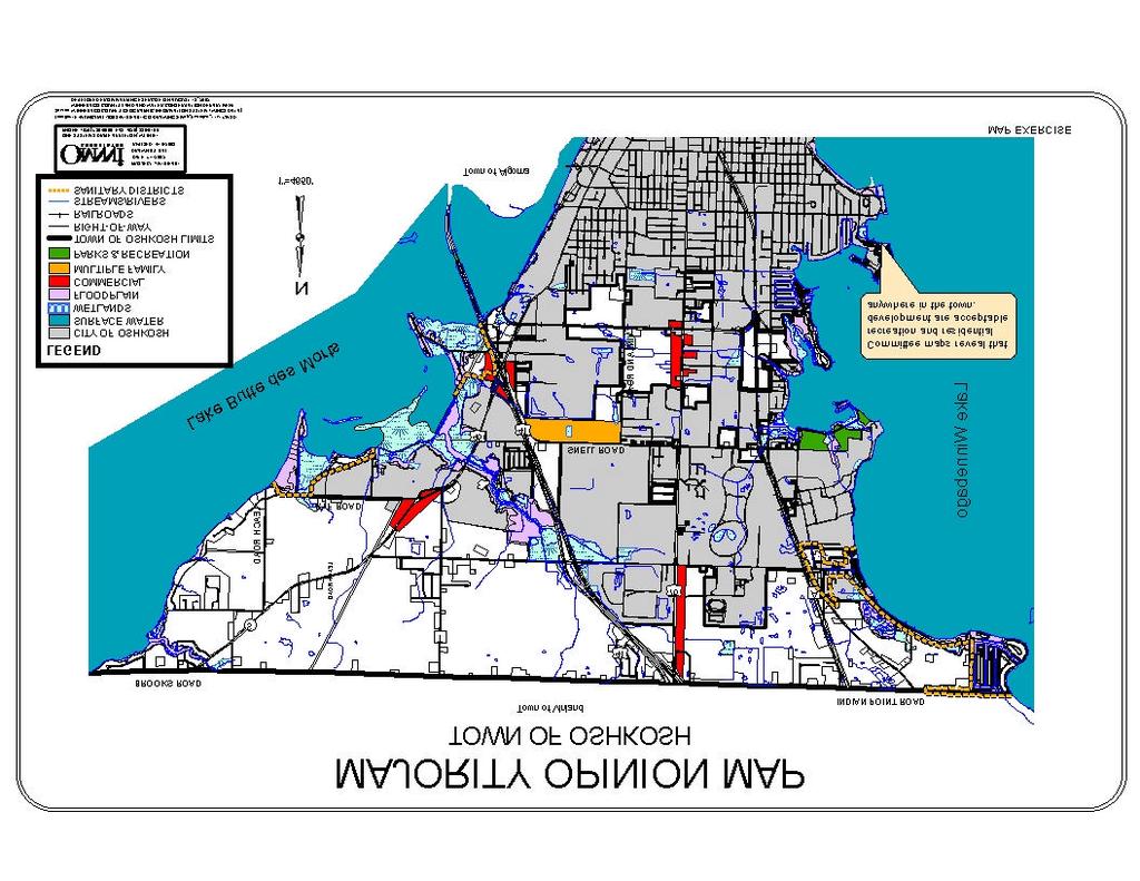
193 F-2
194 APPENDIX G: BUILDING LIMITATIONS MAPS This appendix includes two maps: Building Suitability and Sanitary Suitability. These maps were developed using the Soil Survey for Winnebago County. The maps indicate severe development limitations exist throughout the community. Town officials have little faith in the accuracy of these maps given the amount of existing development that has occurred throughout the town with no problems. Moreover, opportunities for development using innovative treatment systems permissible through COMM 83 are not taken into consideration by these maps. The town supports the provisions of COMM 83 as a way to address development limitations. These maps are simply being included in this appendix to fulfill the requirements of the Comprehensive Planning Grant Program of WI 1999 Act 9. G-1
195 G-2
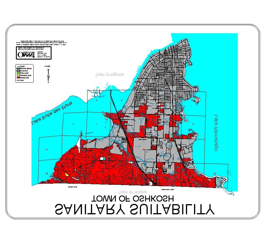
196 G-3
CHAPTER 1: INTRODUCTION
 CHAPTER 1: INTRODUCTION MAP OF OUTAGAMIE COUNTY, WI N 1 = 6 miles INTRODUCTION The Town and Village of Black Creek are located in central Outagamie County, Wisconsin. The Village is located in the north
The Town of Hortonia shares borders with: the Town of Ellington, Town of Greenville, Town of Dale, New London, Hortonville and Waupaca County.
 1.0 INTRODUCTION Where is the Town of Hortonia? The Town of Hortonia is located in west central Outagamie County, Wisconsin, between Hortonville and New London. The Wolf River forms the Town s northern
Comprehensive Plan. Faribault, Minnesota. Hoisington Koegler Group Inc. Claybaugh Preservation Architecture Inc. Howard R. Green Company Bonz/REA
 Comprehensive Plan Faribault, Minnesota Adopted by the Faribault City Council July 8, 2003 prepared for: prepared by: Hoisington Koegler Group Inc. Claybaugh Preservation Architecture Inc. Howard R. Green
Town of Peru Comprehensive Plan Executive Summary
 Town of Peru Comprehensive Plan Executive Communities that plan grow by choice, not by chance. A plan makes growth thoughtful, understandable, and predictable. A plan shows that a community is managing
Chapter 10 IMPLEMENTATION RECOMMENDATIONS
 Chapter 10 IMPLEMENTATION RECOMMENDATIONS The recommended land use plan presented in the previous chapter provides a design for the attainment of the urban and rural development and open space preservation
City of Royalton Comprehensive Land Use Plan 2005 to Revision February 8, 2011
 City of Royalton Comprehensive Land Use Plan 2005 to 2015 2011 Revision February 8, 2011 PART ONE: INTRODUCTION TO THE COMPREHENSIVE PLAN 1.0 Purpose and Introduction The Comprehensive Land Use Plan provides
2018 Northampton Township Comprehensive Plan
 2018 BUCKS COUNTY, PENNSYLVANIA What is a? A comprehensive plan is a municipality s main policy document that details the collective vision for the future, the historic, environmental, and cultural facilities
Chapter 2: Vision, Goals and Strategies
 Chapter 2: Vision, Goals and Lake Elmo Today & Tomorrow Comprehensive Plan 2040 2 VISION, GOALS & STRATEGIES - DRAFT 4-6-2018 INTRODUCTION Comprehensive Plan Purpose Perhapse the most important objective
HAZARD MITIGATION GOALS AND OBJECTIVES
 SEWRPC Community Assistance Planning Report No. 282, 2nd Edition CITY OF MILWAUKEE ALL HAZARDS MITIGATION PLAN UPDATE Chapter IV HAZARD MITIGATION GOALS AND OBJECTIVES [NOTE: Throughout this plan update
This chapter describes the purpose of the Plan, introduces how the Plan is organized and provides contextual background for the Plan.
 Chapter 1: INTRODUCTION Purpose of a Comprehensive Plan The 2040 Comprehensive Plan establishes Medina s vision as a community and sets goals and objectives which guide future decisions and policies. The
2040 LUP is a part of the Comprehensive Plan and carries the same legal authority. Economic Challenges
 1.1. Guiding Anchorage s Growth Where will new residents settle over the next two decades? Where will people work, shop, and play? Will there be enough room to grow? How will Anchorage look? Will growth
7Page 1 CLEMMONS COMMUNITY COMPASS 1 PLAN OVERVIEW
 1 Plan Overview WHAT IS I THE CLEMMONS COMMUNITY COMPASS? The Clemmons Community Compass is our community s comprehensive plan. It serves as our blueprint and provides direction for the future of the Village
This page intentionally blank.
 This page intentionally blank. Parks, Recreation, and Open Space Chapter Relationship to Vision Vision Parks, Recreation and Open Space Chapter Concepts County Government. County government that is accountable
Concord Community Reuse Project Goals and Guiding Principles. Overarching Goals (OG)
") Concord Community Reuse Project Goals and Guiding Principles Overarching Goals (OG) No priority is implied by the order of presentation of the goals and guiding principles. Overarching goals for the Concord
Concord Community Reuse Project Goals and Guiding Principles Overarching Goals (OG) No priority is implied by the order of presentation of the goals and guiding principles. Overarching goals for the Concord
12 Intergovernmental Coordination
 Intergovernmental Coordination Supporting Data The purpose of the Intergovernmental Coordination Element is to identify and resolve incompatible goals, objectives, policies and development proposed in
Laberge Group. Town of Coeymans. Draft Comprehensive Plan. Overview of Planning Process
 Draft : Presentation of Goals & Strategies Laberge Group Benjamin H. Syden, A.I.C.P., E.D.P Director in Charge Nicole Allen, A.I.C.P. Senior Planner Anjali Malhotra Planner Presentation Outline Introductions
SALISBURY TOMORROW Our Vision
 SALISBURY TOMORROW Our Vision Salisbury is committed to supporting a high quality of life and sense of community for all residents. These commitments need to be reflected in our community programs, services
Denton. A. Downtown Task Force
 2 Public Involvement Early and ongoing public involvement was solicited so that the public had ample opportunity to help direct the DTIP s concepts and implementation strategies. The residents of Denton
Arlington, Virginia is a worldclass
 EXECUTIVE S U M M A RY Arlington maintains a rich variety of stable neighborhoods, quality schools and enlightened land use policies, and received the Environmental Protection Agency s highest award for
Port Lavaca Future Land Use
 Port Lavaca Future Land Use Introduction The City of Port Lavaca is beginning to see sustained growth, after many years of relative stable population. New single family homes, apartments, and businesses
2010 Plan of Conservation and Development
 2010 Plan of Conservation and Development Wilton Planning and Zoning Commission Adopted November 2, 2009 Effective January 1, 2010 WILTON 2010 PLAN OF CONSERVATION & DEVELOPMENT PARTICIPANTS Planning &
CHAPTER 3 VISION, GOALS, & PLANNING PRINCIPLES. City of Greensburg Comprehensive Plan. Introduction. Vision Statement. Growth Management Goals.
 CHAPTER 3 VISION, GOALS, & PLANNING PRINCIPLES Introduction The Greensburg Comprehensive Plan is intended as a working community document. A combination of long and short-term goals, this document is intended
CITY OF COLWICH COMPREHENSIVE PLAN LAND USE LAND USE 1
 LAND USE LAND USE 1 WHAT YOU WILL FIND IN THIS CHAPTER: Discussion of today s conditions and tomorrow s projections Discussion of challenges and opportunities Discussion of the environmental quality goals,
TREASURE COAST REGIONAL PLANNING COUNCIL M E M O R A N D U M. To: Council Members AGENDA ITEM 5H
 TREASURE COAST REGIONAL PLANNING COUNCIL M E M O R A N D U M To: Council Members AGENDA ITEM 5H From: Date: Subject: Staff October 17, 2008 Council Meeting Local Government Comprehensive Plan Review Draft
Envision Front Royal Workshop 1 of 2
 Envision Front Royal Workshop 1 of 2 September 12, 2013 Summary The Envision Front Royal project held the first of two public workshops on September 12, 2013. The purpose of the workshop was to evaluate
DRAFT Amsterdam/Churchill Community Plan (4/17/08) Adopted By the Gallatin County Commission
 Adopted By the Gallatin County Commission") DRAFT Amsterdam/Churchill Community Plan (4/17/08) Adopted By the Gallatin County Commission Table of Contents Acknowledgements Chapter 1: Introduction A Brief History What s Next Authority Organization
DRAFT Amsterdam/Churchill Community Plan (4/17/08) Adopted By the Gallatin County Commission Table of Contents Acknowledgements Chapter 1: Introduction A Brief History What s Next Authority Organization
WATERFORD Plan of Preservation, Conservation and Development Supplement Part 1 - Policy Element
 WATERFORD 2012 Plan of Preservation, Conservation and Development 2015 Supplement Part 1 - Policy Element Effective June 11, 2015 2015 Plan Update GOAL To respond to the evolving land use needs and continually
EXECUTIVE SUMMARY DRAFT CHAPTER 1 INTRODUCTION EXECUTIVE SUMMARY
 CHAPTER 1 EXECUTIVE SUMMARY INTRODUCTION Through the joint efforts of the City of Tulsa planning staff and the Land Services division of Indian Nations Council of Governments (INCOG), the Berryhill Land
PSRC REVIEW REPORT & CERTIFICATION RECOMMENDATION
 PSRC REVIEW REPORT & CERTIFICATION RECOMMENDATION KITSAP COUNTY COUNTYWIDE PLANNING POLICIES July 2, 2012 BACKGROUND A major emphasis of the Washington State Growth Management Act (GMA) is the need to
ELK GROVE GENERAL PLAN VISION
 2-1 CHAPTER 2: 2-2 CREATING OUR The Community Vision for Elk Grove, expressed through a Vision Statement and a series of Supporting Principles, is a declaration of the kind of community that Elk Grove
LU Encourage schools, institutions, and other community facilities that serve rural residents to locate in neighboring cities and towns.
 Application No. 891627: Comprehensive Plan Text Amendment - Rural School Policies - Amend policies consistent with State Legislation allowing schools in the rural area and extension of sewer service to
2.7 ac park. TOTAL 5,403 DU 1,297,900 sf 1,105,450 sf 3.87 ac 5,563 DU 1,121,200 sf 1,105,450 sf 3.87 ac
 PLAN AMENDMENT 2013-I-B1: SEVEN CORNERS SPECIAL STUDY Summary of Pre-staffing Comments Planner: Bernard Suchicital bsuchi@fairfaxcounty.gov (703) 324-1254 Background On October 29, 2013, the Board of Supervisors
Improve Neighborhood Design and Reduce Non Point Source Water Pollution
 HOW TO Planning Guide Improve Neighborhood Design and Reduce Non Point Source Water Pollution This document was funded by a grant from the New Hampshire Coastal Program with funding from the National Oceanic
CITY OF CHARLOTTESVILLE, VIRGINIA CITY COUNCIL AGENDA
 CITY OF CHARLOTTESVILLE, VIRGINIA CITY COUNCIL AGENDA Agenda Date: December 16, 2013 Action Required: Adoption of Resolution Presenter: Staff Contacts: Title: James E. Tolbert, AICP, Director of NDS James
How To Get the Development You Planned
 How To Planning Series Prepared by Strafford Regional Planning Commission. Funded by the NH Office of State Planning How To Get the Development You Planned The purpose of the master plan is... to guide
CHAPTER 12 IMPLEMENTATION
 CHAPTER 12 IMPLEMENTATION The 2010 Town of Denton Comprehensive Plan is intended to capture a vision of the future of Denton. As such, it provides a basis for a wide variety of public and private actions
CHAPTER VI Plan Implementation
 Versailles-Midway CHAPTER VI Plan Implementation While prior sections focused on the tools the Commission needs to help it make the dayto-day decisions associated with subdivision, site plan and rezoning
MEMORANDUM AGENDA ITEM #6c
 South Florida Regional Planning Council MEMORANDUM AGENDA ITEM #6c DATE: FEBRUARY 1, 2010 TO: FROM: SUBJECT: COUNCIL MEMBERS STAFF CITY OF PARKLAND PROPOSED COMPREHENSIVE PLAN AMENDMENT (ALTERNATIVE REVIEW)
Ridgefield and the Growth Management Act
 1 2 Ridgefield and the Growth Management Act 3 Why Do We Plan History of Planning in Ridgefield Washington experiences rapid growth in the late 1980 s that began to change the perceived quality of life.
A BLUEPRINT FOR BROCKTON A CITY-WIDE COMPREHENSIVE PLAN
 A BLUEPRINT FOR BROCKTON A CITY-WIDE COMPREHENSIVE PLAN Public Meeting October 2016 1 Plan Summary and Discussion Public Meeting May 4 2017 City of Brockton Bill Carpenter, Mayor Department of Planning
Plan Overview. Manhattan Area 2035 Reflections and Progress. Chapter 1: Introduction. Background
 Plan Overview The Manhattan Urban Area Comprehensive Plan (the Comprehensive Plan) is a joint planning initiative of the City of Manhattan, Pottawatomie County, and Riley County. The 2014 Comprehensive
2035 General Plan Update and Belmont Village Specific Plan. Joint Study Session with the City Council and Planning Commission April 12, 2016
 2035 General Plan Update and Belmont Village Specific Plan Joint Study with the City Council and Planning Commission April 12, 2016 Agenda 1. Welcome and Introductions 2. General Plan Update Status of
Purpose of the Master Plan
 Purpose of the Master Plan 4 Master Plan Purpose The Master Plan is a policy framework for decisions that affect the physical, social and economic environment of the Town. The Parker 2035: Master Plan
9.0 EXISTING LAND USE
 9.0 EXISTING LAND USE Table of Contents Introduction...117 Existing Land Use and Zoning...117 Existing Land Use Breakdown...117 Town of Nekimi Existing Land Use Map...119 Town of Nekimi Zoning Map...121
Land Use Amendment in Southwood (Ward 11) at and Elbow Drive SW, LOC
 at and Elbow Drive SW, LOC") 2018 November 15 Page 1 of 10 EXECUTIVE SUMMARY This land use amendment application was submitted by Rick Balbi Architect on 2017 August 31 on behalf of Sable Developments Ltd, and with authorization from
2018 November 15 Page 1 of 10 EXECUTIVE SUMMARY This land use amendment application was submitted by Rick Balbi Architect on 2017 August 31 on behalf of Sable Developments Ltd, and with authorization from
Urban Planning and Land Use
 Urban Planning and Land Use 701 North 7 th Street, Room 423 Phone: (913) 573-5750 Kansas City, Kansas 66101 Fax: (913) 573-5796 Email: planninginfo@wycokck.org www.wycokck.org/planning To: From: City Planning
PREVIOUS PUBLIC PARTICIPATION BRIEF October 2014
 Comprehensive Planning During the development of the county comprehensive plan, Cultivating Community: A Plan for Union County s Future from 2007 through 2009, and three concurrent multi municipal plans
Town of Union Year 2030 Comprehensive Plan
 Town of Union Year 2030 Comprehensive Plan Contents Page 1. Issues and Opportunities... 1-1 1.1 Introduction 1-1 1.2 Plan Summary 1-2 1.3 Town of Union 2030 Vision 1-7 1.4 Comprehensive Plan Development
Joint Meeting City Council and the Plan Commission. September 1st, 2015
 Joint Meeting City Council and the Plan Commission September 1st, 2015 1 The City Plan Commission shall recommend a City Plan for the physical development of the City Article IX Section 2 of the City of
PLANNING ADVISORY BOARD AGENDA OCTOBER
 ! City of Langley PLANNING ADVISORY BOARD AGENDA OCTOBER 1, 2014 3-5pm LANGLEY CITY HALL - 112 2 nd Street, Langley WA 1) Call to Order and Roll Call 2) Approval of the Minutes September 10, 2014 3) Public
CHAPTER 3 COMMUNITY DEVELOPMENT GOALS AND OBJECTIVES LEESPORT BOROUGH - ONTELAUNEE TOWNSHIP - PERRY TOWNSHIP IOINT COMPREHENSIVE PLAN
 COMMUNITY DEVELOPMENT GOALS AND OBJECTIVES IOINT COMPREHENSIVE PLAN COMMUNITY PARTICIPATION To be effective, this Comprehensive Plan must reflect the common goals of the residents of the Planning Area.
Implementation Vision
 Introduction The implementation chapter is the how to portion of the plan. It describes the actions necessary to realize the visions presented in this document through the goals, objectives, and policies
COMMISSION ACTION FORM
 ITEM #: 6 DATE: 09-06-17 COMMISSION ACTION FORM REQUEST: Introduction and Initial Review of Proposed Amendments to the Ames Urban Fringe Future Land Map for the North Growth Gap Area BACKGROUND INFORMATION:
OVERVIEW OF PLANS FOR THE JEFFERSON COUNTY COUNTRYSIDE FARM In the Context of Quality Place Characteristics
 OVERVIEW OF PLANS FOR THE JEFFERSON COUNTY COUNTRYSIDE FARM In the Context of Quality Place Characteristics By Steve Grabow, Professor and Community Development Educator University of Wisconsin-Extension,
CITY CLERK. Parkland Acquisition Strategic Directions Report (All Wards)
") CITY CLERK Clause embodied in Report No. 10 of the, as adopted by the Council of the City of Toronto at its meeting held on November 6, 7 and 8, 2001. 10 Parkland Acquisition Strategic Directions Report
CITY CLERK Clause embodied in Report No. 10 of the, as adopted by the Council of the City of Toronto at its meeting held on November 6, 7 and 8, 2001. 10 Parkland Acquisition Strategic Directions Report
SECTION 1 Introduction...1. SECTION 2 Regional Context Criteria for Planning Districts Description of Planning District...
 Table of Contents SECTION 1 Introduction...1 SECTION 2 Regional Context...2 2.1 - Criteria for Planning Districts...2 2.2 - Description of Planning District...2 SECTION 3 Goals & Objectives...5 SECTION
Introduction. Chapter 1. Purpose of the Comprehensive Plan Plan Organization Planning Process & Community Input 1-1
 Chapter 1 Introduction Lakewood 2025: Moving Forward Together Purpose of the Comprehensive Plan Plan Organization Planning Process & Community Input 1-1 Purpose of the Comprehensive Plan The Comprehensive
MAYFIELD WEST SECONDARY PLAN PHASE 2
 MAYFIELD WEST SECONDARY PLAN PHASE 2 Public Open House #3 February 25, 2010 Draft Preferred Land Use Scenario TOWN OF CALEDON PLANNING & DEVELOPMENT DEPARTMENT Open House Agenda TOWN OF CALEDON 1. Welcome
SECTION II SECTION II STATEMENT OF GOALS, OBJECTIVES, PRINCIPLES, ASSUMPTIONS, POLICIES AND STANDARDS
 STATEMENT OF GOALS, OBJECTIVES, PRINCIPLES, ASSUMPTIONS, POLICIES AND STANDARDS 1 2 STATEMENT OF GOALS, OBJECTIVES, PRINCIPLES, ASSUMPTIONS, POLICIES AND STANDARDS INTRODUCTION The New Jersey Municipal
Section 4 BUILDING THE MASTER PLAN
 The Master Plan 33 Section 4 BUILDING THE MASTER PLAN Figure 4:1. A collaborative effort characterized the two design workshops sponsored by DISC to create hypothetical Master Plans for the Towers Property
Sorted citizen input comments in review of Blount County plans July, August, and September 2007
 Sorted citizen input comments in review of Blount County plans July, August, and September 2007 The following presents sorted citizen input comments from three sessions held in July, August and September
Purpose of the Master Plan
 Purpose of the Master Plan 4 Master Plan Purpose The Master Plan is a policy framework for decisions that affect the physical, social and economic environment of the Town. The Parker 2035: Master Plan
Draft Stillwater 2030 Comprehensive Plan- Goals and Policies
 Draft Stillwater 2030 Comprehensive Plan- Goals and Policies Instructions- Review each goal and policy and discuss with group any changes, deletions for additions to the list using your groups pen. Keep
Preliminary Plan Framework: Vision and Goals
 Preliminary Plan Framework: Vision and Goals Draft: May 2015 Introduction Since the Town of Milliken s comprehensive plan was last updated in 2010, the community was heavily impacted by the 2013 flood,
The transportation system in a community is an
 7 TRANSPORTATION The transportation system in a community is an important factor contributing to the quality of life of the residents. Without a sound transportation system to bring both goods and patrons
Envision Concord Public Event Part 3. October 21, :30 AM 12:00 PM Concord-Carlisle High School Cafeteria
 Envision Concord Public Event October 21, 2017 9:30 AM 12:00 PM Concord-Carlisle High School Cafeteria Survey Responses + Emerging Priority Areas Summary from Spring Kick-Off Event Envision Concord Survey
Chapter 1 Vision Statement & Goals
 Chapter 1 Section 1.1 Section 1.2 Section 1.3 Section 1.4 Section 1.5 Introduction Vision Statement Visioning Exercise Prioritization of Land Use Issues Goals of the Comprehensive Plan CHAPTER 1 SECTION
1.0 Purpose of a Secondary Plan for the Masonville Transit Village
 Report to Planning and Environment Committee To: Chair and Members Planning & Environment Committee From: John M. Fleming Managing Director, Planning and City Planner Subject: Masonville Transit Village
SECTION 4(f) DE MINIMIS DOCUMENTATION
 DE MINIMIS DOCUMENTATION") SECTION 4(f) DE MINIMIS DOCUMENTATION Illinois Route 60/83 IL 176 to the intersection of IL 60 (Townline Road) Lake County P-91-084-07 Mundelein Park and Recreation District Project Limit SECTION 4(f)
SECTION 4(f) DE MINIMIS DOCUMENTATION Illinois Route 60/83 IL 176 to the intersection of IL 60 (Townline Road) Lake County P-91-084-07 Mundelein Park and Recreation District Project Limit SECTION 4(f)
Regional Context Statement
 Regional Context Statement REGIONAL CONTEXT STATEMENT 3. REGIONAL CONTEXT STATEMENT In 1995, the Provincial Government passed into law the Growth Strategies Act. The purpose of this provincial initiative
TABLE OF CONTENTS. Transportation Chapter 1 - Introduction and Purpose of Planning to 1-3. Utilities
 Chapter 1 - Introduction and Purpose of Planning... 1-1 to 1-3 Pennsylvania Municipalities Planning Code (Act 247)...1-1 Previous County Planning Activities...1-1 Objectives of the Plan...1-2 Elements
Official Plan Review
 Official Plan Review Summary Report - The Built Environment August 2014 Part 1: Introduction Planning for a healthy, prosperous and sustainable community is an important goal for our municipality. From
Economy Vision Statements: Social Wellbeing Vision Statements: Natural Environment Vision Statements:
 Economy Vision Statements: 1. Our business environment makes us a region of choice for new employers as we encourage entrepreneurship and have a vibrant, diversified and resilient regional economy. 2.
LAND USE ELEMENT. Purpose. General Goals & Policies
 LAND USE ELEMENT Purpose This Land Use Element contains the goals and policies necessary to support the City s responsibility for managing land resources and guiding development through implementing regulations,
SUBJECT: Waterfront Hotel Planning Study Update TO: Planning and Development Committee FROM: Department of City Building. Recommendation: Purpose:
 Page 1 of Report PB-23-18 SUBJECT: Waterfront Hotel Planning Study Update TO: Planning and Development Committee FROM: Department of City Building Report Number: PB-23-18 Wards Affected: 2 File Numbers:
Cumberland Region Tomorrow is a private, non-profit, citizen based regional organization working with Greater Nashville Regional Council
 Cumberland Region Tomorrow is a private, non-profit, citizen based regional organization working with Greater Nashville Regional Council and others in the public and private sectors, dedicated to planning
Planned Development Review Revisions (Project No. PLNPCM )
") Planned Development Review Revisions (Project No. PLNPCM2014-00139) Standard residential development Planned Development Example: Smaller lot sizes than what is allowed to create open space amenity. What
Planned Development Review Revisions (Project No. PLNPCM2014-00139) Standard residential development Planned Development Example: Smaller lot sizes than what is allowed to create open space amenity. What
Chapter Master Planned Communities (MPC) District
 District") Sections 14.53.010 Purpose and Intent 14.53.020 Applicability 14.53.030 Procedure 14.53.040 MPC Standards 14.53.050 Required Findings 14.53.010 Purpose and Intent Chapter 14.53 Master Planned Communities
Sections 14.53.010 Purpose and Intent 14.53.020 Applicability 14.53.030 Procedure 14.53.040 MPC Standards 14.53.050 Required Findings 14.53.010 Purpose and Intent Chapter 14.53 Master Planned Communities
PRELIMINARY REPORT. HIGHWAY 18 CORRIDOR NEIGHBORHOOD PLAN VILLAGE OF DOUSMAN November, 2014
 PRELIMINARY REPORT HIGHWAY 18 CORRIDOR NEIGHBORHOOD PLAN VILLAGE OF DOUSMAN November, 2014 This preliminary report presents the initial recommendations for land use within the Highway 18 corridor along
6 Growth Management Challenges and Opportunities
 6 Growth Management Challenges and Opportunities The Town has established a goal of attaining a 50% participation rate with respect to employment opportunities versus residential population. The Town s
TOWN OF BRUDERHEIM Report to the capital region board
 TOWN OF BRUDERHEIM Report to the capital region board Introduction to the Town of Bruderheim Municipal Development Plan amendment and Relation to the CRB Evaluation Criteria 02 march 2017 1 Introduction
S A C R A M E N T O C O U N T Y JACKSON HIGHWAY & GRANT LINE EAST VISIONING STUDY
 JACKSON HIGHWAY & GRANT LINE EAST S A C R A M E N T O C O U N T Y P L A N N I N G D E P A R T M E N T SUMMARY AND WORKBOOK November 19, 2008 History of the Visioning Study Sacramento County has two growth
East Central Area Plan
 East Central Area Plan Steering Committee Meeting January 10 th, 2019 Tears-McFarlane House Community Room East Central Area Plan Steering Committee Meeting January 10 th, 2019 CHUN Tears-McFarlane House
Gloucester County s Comprehensive Plan. The Community Connection
 Gloucester County s Comprehensive Plan The Community Connection Current Comp Plan Adopted in 1991 with a 20 year planning horizon Updated in 1995 with Part V- Implementation Recommendations and Appendix
City of Heath. Town Center Concept
 In the give-and-take of getting projects designed, financed, and approved, the famous refrain from the film Field of Dreams is heard often: if you build it, they will come. From the perspective of the
TRANSPORTATION AND LAND USE
 CHAPTER 10 TRANSPORTATION AND LAND USE Transportation and land use are intimately linked. The expansion of a highway typically spurs housing, employment growth and land development in the communities that
implementation10 Village of Greendale Comprehensive Plan: Greendale, Wisconsin. Revisiting a Greenbelt Community
 implementation10 Village of Greendale Comprehensive Plan: 2010 - Village of Greendale Comprehensive Plan: 2010 - Implementation The recommendations of this Plan must be implemented by the Village of Greendale,
John M. Fleming Managing Director, Planning and City Planner. Old East Village Dundas Street Corridor Secondary Plan Draft Terms of Reference
 Report to Planning and Environment Committee To: From: Subject: Chair and Members Planning & Environment Committee John M. Fleming Managing Director, Planning and City Planner Old East Village Dundas Street
Preface. Erie. Scranton. Allentown. Pittsburgh. Harrisburg. Philadelphia
 The Southern Alleghenies Region The Southern Alleghenies Region spans the Laurel Highlands and Allegheny Front in the west across the Appalachians to the east. It is comprised of Blair, Bedford, Cambria,
Executive Summary and Introduction
 Section I Executive Summary and Introduction Introduction Purpose and Implementation Vision Themes and Strategies Description of Plan Methodology and Approach History of Comprehensive Planning Page 1 of
Wasatch CHOICE for 2040
 Wasatch CHOICE for 2040 Economic Opportunities We Can Choose a Better Future We enjoy an unparalleled quality of life along the Wasatch Front. People from all over the world are drawn to our stunning scenery,
Request for Statement of Interest in Implementation of the Roosevelt Road Redevelopment Plan
 425 Hillside Avenue Request for Statement of Interest in Implementation of the Roosevelt Road Redevelopment Plan I. INTRODUCTION The is seeking the services of a qualified consulting firm to prepare plans
Implementation Guide Comprehensive Plan City of Allen
 Implementation Guide 2030 Comprehensive Plan City of Allen DRAFT 2015 Implementation Guide Allen 2030 Comprehensive Plan INTRODUCTION The Comprehensive Plan serves as a guide for the growth and development
2. AGENCY COORDINATION AND PUBLIC INVOLVMENT
 2. AGENCY COORDINATION AND PUBLIC INVOLVMENT This chapter discusses the process carried out for conducting agency coordination and public involvement activities. TECHNICAL ADVISORY COMMITTEE A Technical
SECTION ONE: INTRODUCTION. introduction
 introduction 1 INTRODUCTION Since it was first established in 1843 as a trading post for the Hudson s Bay Company, Victoria has evolved into a Provincial capital city that is recognized across Canada and
Capital Area Regional Planning Commission. DANE COUNTY LAND USE & TRANSPORTATION PLAN Amended Goals and Objectives
 Capital Area Regional Planning Commission DANE COUNTY LAND USE & TRANSPORTATION PLAN Amended Goals and Objectives CARPC Redline Review Draft 12/14/07 as amended and adopted on 2/28/08* *changes indicated
Woodburn Comprehensive Plan Growth Management Goals and Policies
 Goal Woodburn Comprehensive Plan Growth Management Goals and Policies G-1. The City's goal is to manage growth in a balanced, orderly and efficient manner, consistent with the City s coordinated population
Benzie County Master Plan: Priority Issues & Opportunities
 Benzie County Master Plan: Priority Issues & Opportunities From March 2015 through January 2016, Networks Northwest staff worked with the Benzie County Master Plan Committee to obtain input from the public
THREE-STEP DESIGN PROCESS FOR OPEN SPACE SUBDIVISIONS
 00216106.DOC NMA/RRK 1/30/14 THREE-STEP DESIGN PROCESS FOR OPEN SPACE SUBDIVISIONS Open space subdivisions, sometimes called cluster developments, maintain a significant portion of a development site in
3. VISION AND GOALS. Vision Statement. Goals, Objectives and Policies
 Vision Statement Queen Creek s interconnected network of parks, trails, open spaces and recreation opportunities provide safe and diverse activities and programs that sustain its unique, small town, equestrian