The Floyds Fork Area Study
|
|
|
- Egbert Alan Maxwell
- 6 years ago
- Views:
Transcription

1 The Floyds Fork Area Study A Framework for Growth Prepared by
2
3 The Floyds Fork Area Study A Framework for the Future October 2010 Prepared by
4
5 ACKNOWLEDGEMENTS Louisville Metro Government Jerry Abramson, Mayor James Mims, AICP, Director, Codes and Regulations Stuart Benson, Council Representative, District 20 Robin Engel, Council Representative, District 22 Charles Cash, AICP, Director (retired) Ken Baker, AICP, Neighborhood and Long Range Planning Supervisor Christopher French, AICP, Planning and Design Coordinator Steve Sizemore, AICP Stakeholders Frannie Aprile, Fisherville Area Neighborhood Association Bill Bardenwerper, Bardenwerper, Talbott & Roberts Brian Bingham, Metropolitan Sewer District Sam Crawford, Kentucky Farm Bureau Joe Daley, 21st Century Parks Pat Dominik, Sabak, Wilson & Lingo Mike Farmer, Fisherville Area Neighborhood Association Jeff Frank, Future Fund John Fischer, Louisville Metro Economic Development Richard Greenberg, Smith Greenberg & Leightty Teena Halbig, Floyds Fork Environmental Association Clarence Hixson, Property Owner John Hodgson, Fisherville Area Neighborhood Association Harrell Hurst, Fisherville Area Neighborhood Association David Kaelin, Tucker Station Neighborhood Association Chuck Kavanaugh, Homebuilders Association of Louisville Kurt Mason, USDA - National Resource Conservation Services Greg Oakley, Hollenbach Oakley LLC Steve Porter, Fisherville Area Neighborhood Association Sonja Ridge, Property Owner Kent Salmon, Property Owner Consultant Team Wallace Roberts & Todd, LLC 1700 Market Street, 28th Floor Philadelphia, PA David Rouse, AICP, ASLA, Principal-in-charge Christopher A. Atkinson, AICP, ASLA, Project Manager Nando Micale, AICP, FAIA, Principal Nancy Oorbeck O Neill, AICP Garlen Capita Kelly Ream David Witham
6 i A FRAMEWORK FOR GROWTH THE FUTURE
7 EXECUTIVE SUMMARY ii EXECUTIVE SUMMARY Louisville s challenge, and the purpose of this plan, is to balance projected population growth and economic development opportunity, the natural and recreational resources of the Floyds Fork Greenway, and the rural and visual character of the Floyds Fork area that residents have come to cherish. The plan recommends higher density development to occur in strategically located, mixed-use, and pedestrian-friendly centers, thus encouraging rural character and natural resources to be maintained in surrounding areas.
8 iii A FRAMEWORK FOR THE FUTURE Findings Continuation of past development trends will result in the fragmentation and alteration of the rural, natural, and agricultural resources outlined in this study. As an alternative to these trends, the concept for the Floyds Fork area s future is designed to accommodate growth while sustaining rural resources and character. The concept is organized around a simple idea: that The Floyds Fork Greenway a continuous, uninterrupted greenway along the Floyds Fork stream valley should form an edge or seam between the expanding Louisville metropolitan area to the west and the more rural, environmentally sensitive lands to the east. Generally west of the Floyds Fork Greenway, public sector policies, regulations, incentives, and investments should encourage a neighborhood development pattern focused on small towns and villages, consistent with the direction for centers set by the Cornerstone 2020 Comprehensive Plan. Generally east of the Greenway, they should encourage conservation development forms that maintain rural character and protect sensitive resources (see Figure ES.1). The Growth Framework divides the Floyds Fork area into sub-areas to which different growth and resource conservation strategies would apply (see figure ES.2): 1. The Neighborhood Development Area comprises areas of existing development and undeveloped lands located mostly west of Floyds Fork. 2. The Core Conservation Area is the Floyds Fork Greenway, within which a 3,200-acre regional park and conservation area is under development. 3. The Low Impact Development Area comprises environmentally sensitive lands and farmland mixed with some existing development east of Floyds Fork. 4. Centers of varying sizes corresponding to the Form District types (Regional, Town, or Village) would be located primarily within the Neighborhood Development Area, but could also be located within the Low Impact Development Area. The map below indicates four priority center locations derived from analysis conducted for this plan. The following general strategies are proposed in each of these sub-areas: Neighborhood Development Area Policy Recommendations 1. Create incentives to promote infill of existing development areas already served by utility and roadway infrastructure. 2. Working with utility providers and the Economic Development Department, develop techniques to fund infrastructure extensions needed to serve new development areas. Center development should be used to focus utility extensions and new development should extend from the new center locations. 3. Develop techniques and/or standards to integrate open space into the land use pattern ( retrofit existing development areas; incorporate into new developments). 4. Use zoning tools to encourage neighborhood-serving commercial uses in neighborhood and village centers. 5. Maintain the Neighborhood Form District within the Neighborhood Development Area. Core Conservation Area Policy Recommendations 6. Protect sensitive resources (Floyds Fork, 100 year floodplain, steep slopes, etc.) as a priority. 7. Adopt the Floyds Fork Greenway Master Plan, including compatible multi-modal facilities (Louisville Loop Trail; trail connections to adjacent neighborhoods, etc.) as a part of Cornerstone 2020 comprehensive plan. 8. Review the current Floyds Fork Development Review Overlay District against current LDC environmental regulations to reduce conflicts and to enhance protection of natural resources.
9 EXECUTIVE SUMMARY iv Low Impact Development Neighborhood Development Neighborhood Development The Floyds Fork Greenway Billtown Road and I-265 Interchange Low Impact Development Neighborhood Development Low Impact Development Figure ES.1: Future Concept Data Source: LOJIC miles
10 v A FRAMEWORK FOR THE FUTURE Low Impact Development Area Policy Recommendations 9. Review current LDC environmental standards to ensure that the integrity of natural and agricultural resources is maintained. 10. Review existing tools and create new development tools that encourage an integrated approach to development and resource conservation. 11. Strategically target utility and roadway infrastructure extensions to support desired development and limit growth impacts on sensitive resources. 12. Integrate significant agricultural and natural areas into the land use pattern through the use of existing and new development tools. 13. Develop standards and tools that preserve existing character while allowing for new development to occur. Centers Policy Recommendations 14. Encourage compact, mixed-use development in existing and proposed centers. The location of additional and/or expansion of existing centers throughout the Floyds Fork area must consider: a. Sufficiency of roadway and sewer infrastructure to support center development b. Sufficiency of access and visibility from highway interchanges for proposed regional centers c. Sufficiency of access and visibility from major thoroughfares for proposed town and village centers d. Sufficiency of adjacent residential density and/or proven economic feasibility to support commercial development in the proposed center location e. Location and proximity of other existing centers f. Environmental suitability of proposed center site (preference should be given to locations west of the Floyds Fork) 15. Serve designated center locations with new infrastruc ture as a priority. 16. Designate center locations as future transit nodes in coordination with TARC. 17. Conduct studies as directed by Metro Council with the goal of form district changes for identified centers in accordance with this study and based on their intended size and function (Regional, Town or Village). Next Steps In an effort to advance the specific ideas raised in the Floyds Fork Area Plan, two major work groups should be convened over the next year: 1. Create a Planning Commission appointed committee to review and make specific recommendations regarding the development of compact, mixed-use activity centers within the Floyds Fork Area Study area as recommended by the study. Use the general guidelines within the Floyds Fork Area Study as a basis for this work. 2. Create a Planning Commission appointed committee to review and make specific recommendations regarding resources for sustainable development within the Floyds Fork Area Study area. Use the general guidelines within the Floyds Fork Area Study as a basis for this work.
11 EXECUTIVE SUMMARY vi Planned Town Center Village Center (or Neighborhood Center) Town Center (or Village Center) Regional Center Village Center (or Neighborhood Center) Figure ES.2: Growth Framework Data Source: LOJIC Neighborhood Development Area Core Conservation Area Low Impact Development Area Centers (NOTE: does not represent actual size of center) Planned Town Center miles
12
13 CONTENTS Executive Summary... ii 1. Introduction A Growth Framework for the Floyds Fork Area Design Guidelines for Centers Implementation...43 Appendix... 52
14 xii A Framework For The Future
15 Chapter Title xiii LIST OF FIGURES Figure ES.1: Future Concept...iv Figure ES.2: Growth Framework... vi Figure 2.1: Existing Parkland and Farmland...9 Figure 2.2: Floodplain and Slope...11 Figure 2.3: Residential Density Figure 2.4: New Proposed Development Figure 2.5: Future Concept...17 Figure 2.6: Proposed Mixed-use Centers Figure 2.7: Growth Framework...21 Figure 3.1: Regional Center Prototype Figure 3.2: Town Center Prototype Figure 3.3: Village Center Prototype Figure A.1: Floyds Fork Design Review Figure A.2: Historic Properties...55 Figure A.3: Population Density...56 Figure A.4: Scenic Corridors and Parkways...57 Figure A.5: Traffic Volumes...58 Figure A.6: 100 Buffer...59 Figure A.7: Land Cover Figure A.8: Karst Areas and Wellhead Protection Zones Figure A.9: Comments from Stakeholders Group Meeting...62
16 A FRAMEWORK FOR GROWTH
17 INTRODUCTION 1 INTRODUCTION The continued eastward expansion of suburban development from Louisville s urban core will impact rural character and natural resources at the eastern edge of Jefferson County. The creation of the Floyds Fork Greenway, a nationally recognized park and open space initiative that has set aside over 3,200 acres of stream bottomland, is a major first step in preserving these resources for future generations. However, the Floyds Fork Greenway itself is likely to increase development interest in the surrounding area as future residents seek to locate within close proximity to its amenities. Louisville s challenge, and the purpose of this plan, is to balance projected population growth and economic development opportunity, the natural and recreational resources of the Floyds Fork Greenway, and the rural and visual character residents have come to cherish. The plan encourages higher density development to occur in strategically located, mixed-use, and pedestrian-friendly centers, essentially creating new small towns and encouraging rural character and natural resources to be maintained in surrounding areas. The following pages describe a growth framework for the eastern fringe of the Louisville Metro region; possible locations for mixed-use centers based on the region s current growth trends; and recommended design guidelines, strategies, and techniques for implementation.
18 2 A FRAMEWORK FOR THE FUTURE Related Studies and On-going Initiatives The Floyds Fork Area Study was developed in coordination with other related and ongoing planning initiatives to ensure consistency with current policy and specific projects already underway for the area. The strategies and recommendations contained herein coalesce and build upon these initiatives. The most significant related studies and initiatives are described below. Cornerstone 2020 Comprehensive Plan (1993 to 2000): In 1993, the Louisville Metro Government initiated a 7-year comprehensive planning process to identify policies and long-term direction for the region s land use, parks and open space, transportation, and economic growth. The process developed an alternative, form-based zoning approach designed to address the limitations of conventional regulations through a flexible land use strategy based on the pattern of traditional neighborhood and commercial development. Form districts were implemented in the revised Land Development Code (LDC) to promote new development that complements the existing pattern and character of the built environment. In suburban communities across the Metro region, the designated form districts enhance the visual character of areas characterized by commercial strip development while promoting pedestrian, bicycle, and transit use. The recommendations of this Floyds Fork Area Study expand and build upon the form district concept established by Cornerstone The Floyds Fork Greenway Master Plan (2008): The Floyds Fork Greenway Master Plan establishes the long-term design direction for a 3,200-acre regional park and greenway proposed for the eastern area of the Louisville Metro region. The plan includes active and passive recreation opportunities, a 27-mile portion of the Louisville Loop multi-purpose trail (see below), and natural and cultural resource areas that preserve sensitive landscapes for wildlife habitat and historic sites for public interpretation. The master plan is the next step toward implementing the vision set forth in the Louisville & Jefferson County Parks and Open Space Master Plan, completed in 1995 and part of Cornerstone 2020 Comprehensive Plan described above. Visionary in its scope and approach to sustainable design, the master plan seeks to increase biodiversity through habitat preservation and enhancement, improve water quality through innovative storm water management techniques, preserve agricultural land, and measure the regional sustainability costs and benefits of master plan proposals implemented over the long-term. City of Parks Initiative (ongoing): On February 22, 2005, Louisville Mayor Jerry Abramson announced a multi-million dollar, multi-year initiative to add thousands of acres of park land and protected green space to the Metro region. This is the most comprehensive effort to expand and improve Louisville s park system since the creation of the Olmsted parks in the 1890s. The addition of land in the Floyds Fork corridor is the single largest addition to the park system since the expansion of Jefferson Memorial Forest in the 1970s. The City of Parks initiative includes: Acquisition and development of new park land The Louisville Loop trail extending over 100 miles around the community tying together Louisville s diverse parks and neighborhoods An unprecedented level of capital investment to improve existing parks The City of Parks Initiative represents a tremendous opportunity to integrate proposed mixed-use center design with the Louisville Loop trail, the Floyds Fork Greenway, and new neighborhood and community parks that serve the needs of Louisville s growing population in the Floyds Fork area. Louisville Metro Complete Streets Manual (manual completed 2007, ordinance adopted 2008): In keeping with the goals of the Cornerstone 2020 Comprehensive Plan, Louisville Metro Government adopted a complete streets policy and developed design guidelines for their imple-
19 INTRODUCTION 3 mentation the Louisville Metro Complete Streets Manual. The manual s guidelines establish a system of streets that provide for safe and effective access to all users in a contextappropriate manner. Louisville Metro s commitment to a complete streets policy is intended to promote the design of transportation corridors that are safe and convenient for pedestrians, bicyclists, motorists, and bus riders of all ages and abilities. Implementing the recommendations of the Complete Streets Manual will ensure safe and equitable access to proposed amenities for the residents of existing and emerging neighborhoods within the Floyds Fork area. Louisville/Jefferson County Metro Retail Infrastructure Analysis (2007): In October of 2007, Louisville Metro Government completed a retail infrastructure analysis that identified both served and underserved market potential areas for goods and services Metro-wide. Recommendations for future retail node locations were identified based on the findings of the analysis. Related conceptual building programs and financial feasibility studies were subsequently conducted. The most significant of the recommended retail nodes was located within the Floyds Fork area at Interstate-265 and Bardstown Road. Findings showed strong demand for a super community shopping center that expands the existing, designated Town Center form district immediately west of I-265. Building Louisville s Local Food Economy (2008): The Building Louisville s Local Food Economy report identified recommendations and strategies for increasing sales of locally grown and produced foods in the Louisville Metro region. Strategies included recommended targeted investments, new policies and private practices, and infrastructure improvements to stimulate local supply and demand in local food production and distribution. The Floyds Fork area is Louisville Metro s farm belt and offers great opportunity to realize local food economy goals. Transportation Studies in the Floyds Fork Area: A number of recent transportation studies have been completed within and adjacent to the Floyds Fork area. These studies identify and prioritize roadway improvement projects such as intersection improvements and signalization, roadway widening and extensions, and new highway interchanges. Further study would be required to determine the impact of these projects on the development of the potential centers identified in this document. All transportation and roadway improvement projects, as well as future transportation planning efforts, should support the development of centers and their improved vehicular connectivity to surrounding neighborhoods. The recent transportation studies include: Taylorsville and Billtown Roads Scoping Studies (2007): These studies defined low-cost, short and long term solutions that address specific deficiencies as well as broader, more all-encompassing alternatives to improve corridor wide capacity and operations along Taylorsville and Billtown Roads. Similar to the I-64 interchange study described below, improvements to Taylorsville Road would have an impact on the potential village center along Taylorsville Road at Fisherville (see pages 18 to 19), as well the town center identified at Billtown at I-265 (see pages 18 to 19). I-64 Interchange and New Connector Alternatives Planning Study (2008): This study investigated a new I-64 interchange in the vicinity of Gilliland Road, along with a new or improved north-south connector road between Taylorsville Road and Shelbyville Road. This new interchange would have an impact on the potential village center along Taylorsville Road at Fisherville (see pages 18 to 19). Cooper Chapel Road Extension (estimated completion 2012): This planned extension of Cooper Chapel Road from Beulah Church Road to Bardstown Road would strengthen the visibility of and access to the potential village center identified along the east side of Bardstown Road (see pages 18 to 19).
20 r 4 A FRAMEWORK FOR THE FUTURE Floyds Fork Area Overview O h INDIANA i v e i o R Downtown Louisville Louisville Metro Preston Hwy Bardstown The Floyds Fork Greenway Study Area The plan area covers approximately 73 square miles (46,583 acres) of the southeastern corner of the Louisville Metro Region (Jefferson County). The area is bounded by I-64 to the north, Preston Highway (State Route 61) and I-265 (the Gene Snyder Freeway) to the west, and the county line to the south and east. Though bounded by major highways, the plan area is generally not well served by transportation corridors. I-265 provides seven north-south interchange access points along the western edge. However, major east-west connections that traverse the area are limited to Taylorsville Road, Taylorsville Lake Road, Bardstown Road, and Preston Highway. The area is also not well served by mass transit. The Transit Authority of River City (TARC) provides express bus service (Route 66) from Bardstown Road and Thixton Lane (the Floyds Fork area s only bus stop), through the communities of Mount Washington and Shepherdsville (both in Bullitt County) to downtown Louisville. Service operates morning and afternoon peak hours only. There is no service on weekends or holidays. Rd Taylorsville Rd The Floyds Fork area has a strong rural character and remains one of the most scenic parts of the Louisville Metro region. The Floyds Fork stream valley bisects the area north to south and remains, for the most part, in a natural state. A predominance of agricultural uses, interspersed with single-family homes on large lots (typically 5 acres or more in size), characterizes the area east of the Floyds Fork. Constrained less by natural topography, the land west of the Floyds Fork is generally more developed than to the east, with denser development pockets along and near Taylorsville Road, Bardstown Road, and Preston Highway. Still denser development lies just outside of the Floyds Fork area across the Gene Snyder Freeway to the west, and across Interstate-64 to the north (see Figure A.7 in Appendix). Much of the Floyds Fork stream valley is part of the Floyds Fork Greenway (see description of master planning process above), a future 3,200-acre regional park that when fully constructed will consist of a wide variety of recreational amenities (multi-use recreational trails, regional and neighborhood parks, natural and cultural resource interpretation areas, etc.). First phase construction is planned to commence in the summer of 2010 and is anticipated to ignite increased development interest in the area.
21 INTRODUCTION 5 The Planning Process What are the issues? Where will growth occur? How do we manage it? What should development look like? How do we make it happen? Existing Conditions Growth Design Principles Stakeholder Input Suitability Analysis Public Meeting Growth Framework Public Meeting Design Guidelines for Centers Implementation Strategies and Recommendations Public Hearing Planning and Growth Trends The Floyds Fork Area Study has been prepared using an open planning process that included extensive input from Floyds Fork area residents and stakeholders. As the process unfolded, it became clear that the protection of existing rural character and natural resources are two critical components that must be addressed. The development of recommendations that balance growth with these qualities was strongly desired. Guided by Louisville Metro Government staff, the process included four general steps. Each step addressed a critical question in order to meet the plan s objectives: Step 1: What are the issues? A thorough review of existing conditions, examination of planning trends, and informational interviews with stakeholders was conducted in this step to identify issues and opportunities important to the future of the Floyds Fork area. An understanding of the factors that contribute to rural character and the area s general quality of life emerged from this step. Step 2: Where will growth occur? How do we manage it? Based on the data collected in step 1, a detailed analysis of growth trends was conducted to determine where growth and new development would likely occur over the mid- to long-term. This information informed the development of a growth framework for the area, specific strategies for managing future growth, and possible locations for future mixeduse development in this part of the Metro region. Step 3: What should development look like? Based on feedback from the area s residents and key stakeholders, general design principles and guidelines were established that describe the desired development character for mixed-use centers, including connections to existing neighborhoods and the Floyds Fork Greenway recreational amenities. Step 4: How do we make it happen? Strategies and recommendations to implement the growth framework were developed in this final step. To facilitate an understanding among the general public about best practices for managing growth, Metro officials hosted an educational series in conjuction with this planning process. Experts spoke on the benefits of strategies such as transfer of development rights and conservation subdivision ordinances.
22 6 A FRAMEWORK FOR GROWTH
23 A GROWTH FRAMEWORK FOR THE FLOYDS FORK AREA 7 A SUSTAINABLE GROWTH FRAMEWORK The primary goal of The Floyds Fork Area Study is to balance the protection of natural resources and rural character with future population growth and economic development opportunity. This section describes the Floyds Fork area s existing conditions that contribute most significantly to rural character, as well as the area s future growth trends in order to identify suitable recommendations that could potentially strike that balance. This review of existing conditions ultimately informed the development of the recommended Growth Framework described in section 2.3.
 include existing and future parkland, existing farmland, and environmentally constrained land.")
24 8 A FRAMEWORK FOR THE FUTURE Existing Conditions: Rural Land Uses The Floyds Fork area has a strong rural character, making it one of the most scenic parts of the Louisville Metro region. The landscape elements that contribute most to rural character (described here as rural land uses) include existing and future parkland, existing farmland, and environmentally constrained land. Measures to minimize the adverse impact of adjacent development on these land uses would allow them to remain intact in the long-term. The Floyds Fork area s rural land uses are described below. Existing and Future Parkland Parks and permanently protected open space in the Floyds Fork area contribute significantly to its established rural character. Figure 2.1 illustrates the extent of existing and future parkland, as well as other significant open space resources, within the Floyds Fork area. As described in Chapter 1, the Floyds Fork Greenway is a major park initiative that is likely to shape the development pattern in this area for the foreseeable future. Totaling over 3,200 acres, the Floyds Fork Greenway includes land owned and managed by three separate entities: 21st Century Parks, a non-profit corporation dedicated to park building in the Louisville area; the Future Fund, Inc., a private land trust that is contributing land and trail easements; and the Louisville Metro Parks Department, which is contributing existing city parkland to the Greenway. Each partner will maintain ownership of their respective land holdings, while agreeing that all land within the Greenway (or portions thereof ) will be publically accessible in perpetuity. Other significant open space resources located throughout the Floyds Fork area include: The Rolleigh Peterson Educational Forest, purchased in summer 2009 by the Kentucky Division of Forestry (KDF) and Louisville Metro Parks, will ultimately become a public park and walnut plantation. Farmland is a predominant land use in the Floyds Fork area, contributing to its rural character. Additional parks and open space land is held by 21st Century Parks, Future Fund, and Louisville Metro Parks Department. Existing Farmland Existing farmland is a predominant land use found throughout the Floyds Fork area, and is perhaps the leading indicator of rural character. Totaling approximately 18,446 acres, the extent of farmland shown in Figure 2.1 is based on the tax assessed use of the property and does not necessarily indicate whether the land is in active production, left fallow, or vacant. As Figure 2.1 indicates, the largest contiguous areas of farmland occur east of the Floyds Fork. Farmland west of the Floyds Fork has become more fragmented over time due to the eastward expansion of the Louisville metropolitan area and access to I-265. Remaining agricultural uses in the area generally include corn, soybeans, cattle grazing, and sod.
 The Floyds Fork Greenway Other Open Space Data Source:")
25 A SUSTAINABLE GROWTH FRAMEWORK 9 Rolleigh Peterson Educational Forest Floyd s Fork Park Fishermans Park Figure 2.1: Existing Parkland and Farmland Farmland (Based on Tax Assessment) The Floyds Fork Greenway Other Open Space Data Source: LOJIC miles

26 10 A FRAMEWORK FOR THE FUTURE Environmentally Constrained Land Environmentally constrained land includes areas with development constraints such as floodplain, steep slopes, and karst landscapes. These resources perform important environmental functions and contribute to the Floyds Fork area s rural character. The 100-year floodplain of the Floyds Fork and its major tributaries is generally limited to narrow valley floors. As indicated in Figure 2.2, steep slopes those 20% and greater occur mostly east of the Floyds Fork, and west of the Fork between I-265 and the plan area boundary north of Chenoweth Run. Karst landscapes are land areas prone to ground subsidence and sinkhole collapse caused by the dissolution of water soluble limestone bedrock. Though the entirety of the Floyds Fork area can be described as karst (see Figure A.8 in Appendix), impacts on the actual development potential of the land are highly localized. Ground subsidence and sinkhole issues can also be mitigated on a site-by-site basis if proper stabilization measures are taken. The Louisville Metro Government recently adopted a karst ordinance that defines the specific procedures applicants must follow when developing in karst prone areas. Floodplain and steep slopes comprise the Floyds Fork area s environmentally constrained land.

27 A SUSTAINABLE GROWTH FRAMEWORK 11 Figure 2.2: Floodplain and Slope 100-Year Floodplain Steep Slope No Slope Data Source: LOJIC miles

28 12 A FRAMEWORK FOR THE FUTURE Existing Conditions: Developed Land Uses The predominant developed land uses in the Floyds Fork area are residential and commercial. Though residential land uses are located throughout the entirety of the area, the highest concentration of residential uses occurs west of the Floyds Fork. Residential uses east of the Floyds Fork consist primarily of homes on large 5-acre lots with convenient access to major arterial roadways. Commercial development is primarily located along major arterials such as Bardstown Road, Preston Highway, and Taylorsville Road, as well a concentrations near I-265 interchanges. The following sections describe the Floyds Fork area s existing residential density, pending commercial and residential development projects, and likely growth trends based on this existing development pattern. Also described is the suitability of land for the development of mixed-use centers, a key feature of the Growth Framework described on pages 20 and 21. The Floyds Fork area s densest residential development occurs between the Bardstown Road and Preston Highway. Residential Density Figure 2.3 illustrates the current pattern of residential development in the Floyds Fork area. To provide a sense of the relative density of development, each dot represents one residential address. The area between Bardstown Road and Preston Highway west of Floyds Fork supports the densest concentrations of residential development. Smaller pockets of residential density occur along, or in areas with convenient access from, major transportation corridors. Environmentally constrained lands east of Floyds Fork are characterized by scattered, large lot residential development.

29 A SUSTAINABLE GROWTH FRAMEWORK 13 Figure 2.3: Residential Density NOTE: 1 dot equals one residential unit Data Source: LOJIC miles
30 APPLEGATELN FAIRMOUNTRD 14 A FRAMEWORK FOR THE FUTURE Current Form Districts Looking at the form district map, Figure 2.3, the vast majority of the study area is located in the Neighborhood form district. This area is comprised primarly of residential use with some commercial at specific intersections. Based on Cornerstone 2020, non-residential development should be located within designated centers. Currently, there is no neighborhood center form district and therefore designations are recognized through the rezoning process. The area along the Preston Highway corridor south of the Gene Snyder Expressway is a combination of Suburban Marketplace Corridor and Suburban Workplace form districts. These form districts include intense commercial use as well as industrial development. Their built form is characteristic of conventional strip-style commercial development and typical suburban business park development. Current Development Pattern Figure 2.4 shows the current development pattern of commercial and residential properties within the study area. Figure 2.4 provides information on residential building permits since 2003, all properties rezoned since 2000, all subdivisions approved since 2000, the location of sewer lines, and the existing boundary of the Development Review Overlay (DRO). The current development pattern for the study area is generally located near I-265 interchanges or along major transportation corridors such as Bardstown Road. The area between Preston Highway and Bardstown Road has seen the greatest amount of development due to a relative lack of environmental constraints and adequate access to sanitary sewers. RUDYLN GOLDSMITHLN JEANINEDR FERN VALLEY RD MINORLN ST HWY841 BARBOURLN BROWNSLN MEADOWDR No Name ST HWY22 BARDSTO WNRD INDIANTRL MCCAWLEYRD Southern D M ud Creek No Nam e SHERBURNLN FURMANBLVD RANGELANDRD itch LYNDO NLN ORMSBYLN TAYLORSVILLE RD MILESLN SIX MILELN ST HWY61 LA GRANGERD LYNDO NLN Middle Fork Beargrass Creek PROGRESSBLVD KLONDIKELN BUECHEL BANKRD Weic her Creek South Fork Beargrass Creek Ced ar Run LOW ERD Pond Creek Fishpool C reek MUDLN Brooks Run Goose Creek No Name Little Goose Creek MANNER DALEDR N HURSTBOURNE PKY BRISCOELN WATTERSONTRL OUTER LOOP MANSLICKRD COOPER CHAPELRD SMYRNAPKY UPSDR S HURSTBOURNE PKY STONY BROOKDR FREYS HILLRD DORSEYLN MOUNT WASHINGTONRD Tan yard Branch Hite Creek SIX MILELN WATTERSONTRL GLASERLN WARDAVE BUNSENPKY PENNSYLVANIA RUNRD Pennsylva n MO SERRD LINN STATIONRD MANSLICKRD FERNDALERD BEULAH CHURCH RD ia Run CHAMBERLAINLN EVERGREENRD BELLEW OODRD CEDAR CREEKRD 60 FAIRGROUNDRD FERN CREEKRD Little Cedar Creek No Na me Cedar Cre ek OLD HENRYRD FERN CREEKRD ENGLISH STATIONRD OLD SHELBYVILLERD BLUEGRASSPKY LOVERSLN SEATO NVILLERD THIXTONLN No Na m e TUCKER STATIONRD EASUMRD No Name Chen oweth CHENOWETH RUNRD URTO NLN OLD BARDSTOWNRD Run Pope L ick C henoweth Run 31E N o Name THIXTONLN Chenoweth Run 265 No Name REHLRD FAIRMOUNTRD Shanks Branch Floyds Fork No Name No Name Wells Run Data Source: LOJIC Floyds Fork POPE LICKRD Floyd Fork P ope L ic k JO HNSONRD Brush Run Floyds Fork Turk ey Run TAYLO RSVILLERD Bro ad R un Sa lt River No Nam e Back Run No Name Floyd F ork Mans Run Long Run TAYLORSVILLE LAKERD B rus h Run Whittakers Run Shaker Run ROUTTRD Tater Run HIG HWAY 148 TAYLORSVILLE LAKE RD Back Ru n Wheelers Run S alt River No Nam e Brus h Run Cane Run Sheckets R u n Broad Run S. Long Ru n No Name Dutchman Creek Figure 2.3: Form Districts Sal t R N o Name Campus CAMPUS DOWNTOWN NEIGHBORHOOD Suburban Marketplace Corridor REGIONAL CENTER SUBURBAN MARKETPLACE CORRIDOR Village SUBURBAN WORKPLACE TOWN CENTER Village Center TRADITIONAL MARKETPLACE CORRIDOR TRADITIONAL NEIGHBORHOOD Regional Center TRADITIONAL WORKPLACE VILLAGE Town Center VILLAGE CENTER NO FORM DISTRICT IN EFFECT Suburban Workplace Corridor Neighborhood miles ive r East Fork G oose C reek Plum Creek Powell Run Likely Future Growth Trends The existing pattern of development in the Floyds Fork area is a strong indicator of the likely pattern of growth in the longterm. The area s growth has historically followed the extension of roadways and sewer mains. Residential and commercial development will likely continue to be concentrated west of the Floyds Fork due to convenient access to existing roadway, highway, and sewer infrastructure. However, significant improve-
 Rezoned (2000-2009) Approved Subdivision (2000-2009) Sewer Lines")
31 A SUSTAINABLE GROWTH FRAMEWORK 15 Figure 2.4: New Proposed Development New Residential ( ) Rezoned ( ) Approved Subdivision ( ) Sewer Lines Floyds Fork DRO Data Source: Louisville Metro Planning and Design Services miles


32 16 A FRAMEWORK FOR THE FUTURE ments to roadways and extension of sewer service would likely be required east of the Floyds Fork in order to accommodate the amount of residential growth anticipated at the borders of the Floyds Fork Greenway. Due to their marketability, the predominant pattern of large, 5-acre residential lots east of the Floyds Fork is also likely to continue. If this development pattern continues, the rural character these large lots are perceived to preserve will likely erode. Future Concept Continuation of current development trends will result in the fragmentation and alteration of the rural, natural, and agricultural resources described in Section 2.1. As an alternative to these trends, the concept for the Floyds Fork area s future is designed to accommodate growth while sustaining the rural resources and character that residents value so highly. The concept is organized around a simple idea: that the Floyds Fork Greenway a continuous, uninterrupted greenway along the Floyds Fork stream valley should form an edge or seam between the expanding Louisville metropolitan area to the west and the more rural, environmentally sensitive lands to the east (see Figure 2.5). Generally west of the Floyds Fork Greenway, public sector policies, regulations, incentives, and investments should encourage a neighborhood development pattern focused on small towns and villages, consistent with the direction for centers set by the Cornerstone 2020 Comprehensive Plan. The portion of this area north of Chenoweth Run and west of the Floyds Fork exhibits many of the same land constraints as the conservation area. Under the LDC, special care and best management practices will need to be utilized for development. Generally east of the greenway, they should encourage conservation development forms that maintain rural character and protect sensitive resources. Land development policy should encourage neighborhood development west of the Floyds Fork (top), the conservation of the Floyds Fork stream valley (middle), and the protection of rural character and sensitive natural resources east of the Floyds Fork (bottom)

33 A SUSTAINABLE GROWTH FRAMEWORK 17 Low Impact Development Neighborhood Development Neighborhood Development The Floyds Fork Greenway Low Impact Development Neighborhood Development Low Impact Development Figure 2.5: Future Concept Data Source: LOJIC miles
34 18 A FRAMEWORK FOR THE FUTURE Cornerstone 2020 Centers Review Guideline 2 of Cornerstone 2020 (Centers), guides the location of centers within the Neighborhood, Village, and Traditional Neighborhood form districts. The basic criteria is location at an intersection with one street classified as a collector level or higher and at least one corner is occupied by existing nonresidential use. Using this criteria, the initial analysis of the study area focused on a review of existing and/or possible center locations. The areas east of Bardstown Road are located within the Neighborhood form district. Analysis was conducted for this area based on the criteria discussed above and the results were used in identifying possible center locations. Additional review criteria was developed by the consultant team and used to further refine center locations (e.g. proximity to parks, infrastructure, enviromental conditions, etc.). The area west of Bardstown Road was not deemed appropriate for center development because the Beulah Church Road area has been developed primarily for residential use as well as the close proximity to the Highview Town Center to the north. In addition, a large amount of non-residential development located around and to the south of the Preston Highway and I-265 interchange is designated Suburban Marketplace Corridor and Suburban Workplace form districts. The development consists of light industrial, office, big box commercial, personal service establishments and restaurants. This area serves the needs of the local community and beyond. Proposed Center Locations Figure 2.6 illustrates proposed locations of higher density, pedestrian-friendly, mixed-use centers a development strategy that would allow rural character and natural resources to be maintained in surrounding areas and a key feature of the Growth Framework described on page 20. The proposed locations of mixed-use centers is based on a thorough review of existing conditions and trends including population growth, environmentally constrained land, proximity to existing and future parkland, roadway connectivity, as well as on-going planning initiatives. Below are explanations and justification for each proposed center location. Bardstown Road at I-265 Bardstown Road and Interstate 265 with intersections of collector roadways such as Brentlinger Lane and with existing non-residential use lends to the idea of a larger scale center in this area. Based on the scale of recently approved and or proposed development, a designation of town or even Regional Center seems appropriate. The size and configuration of this center is still to be determined. The Retail Market Strategy that was approved by Metro Council and adopted as part of the comprehensive plan points to the need for Regional Center scale development in this area. Further analysis was conducted using the minimum locational requirements developed for this study such as proximity to population centers, existing infrastructure, non-residential land uses, and the Bardstown Road and the I-265 interchange. In addition, the current trip levels along Bardstown Road justify the need for additional commercial development in this area. This study proposes a Regional Center level development based on the the criteria listed above. Bardstown Road between Thixton Lane and Proposed Cooper Chapel Road Extension Between Thixton Lane and the planned intersection of Cooper Chapel Road Extension and Bardstown Road. This location is at the intersection of an arterial (Bardstown Rd.) and a collector level roadway (Thixton and/or Cooper Chapel Rd.) with existing non-residential at one corner of the intersection at Thixton and Bardstown Road. The location of Old Bardstown Road parallel to and connecting with Thixton Lane supports the location of a small to possibly medium scale center such as a neighborhood or town center. The comprehensive plan acknowledges such intersections qualify as possible locations for an activity center. The Fern Creek Small Area Plan recommended the location of a neighborhood center at Bardstown Road and Thixton Lane. Further analysis was conducted using the minimum locational requirements developed for this study. Also, additional commercial property was rezoned to the north in close proximity to the Fern Creek Fire Station #2. This area is currently appropriate for a village or neighborhood center. Billtown Road and I-265 Interchange This location is at the intersection of an arterial (Billtown Rd.) and a collector level roadway (Gelhaus Lane) with existing non-residential at one corner of the intersection. The comprehensive plan acknowledges such intersections qualify as possible locations for an activity center. The scale of development, surrounding form district and existing environ-

35 A SUSTAINABLE GROWTH FRAMEWORK 19 Taylorsville Raod and Taylorsville Lake Road (Fisherville) Taylorsville Road and Proposed Urton Lane Extension (Tyler Town Center) Billtown Road and I-265 Interchange Bardstown Road at I-265 Bardstown Road between Thixton Lane and Proposed Cooper Chapel Road Extension Figure 2.6: Proposed Mixed-use Centers Data Source: LOJIC Proposed Center Locations Planned Center miles
36 20 A FRAMEWORK FOR THE FUTURE mental constraints suggest that this area would be appropriate for a small to medium scale center such as a neighborhood or town center. Further analysis was conducted using the minimum locational requirements developed for this study. Currently, the development potential exists on the north side of the interchange with limited available land to the south. This study proposes a Town Center level development at this interchange. The north side of the interchange currently contains a elementary and middle school with large residential developments nearby. The greatest potential for a future Town Center is on the northwest corner of the interchange with smaller scale development possible on the southeast corner of the interchange. Any development on the southeast corner would have the greatest potential to impact nearby parks and greenways. Taylorsville Road and Taylorsville Lake Road (Fisherville) This is an intersection of an arterial and a collector level roadway with one corner of the intersection occupied by non-residential use. The comprehensive plan acknowledges such intersections qualify as possible locations for an activity center. The scale of development, surrounding form district and existing environmental constraints suggest that this area would be appropriate for a smaller scale center such as a neighborhood or village center. Further analysis was conducted using the minimum locational requirements developed for this study. This study proposes a village or neighborhood center at this location. Figure 2.2 illustrates the amount of environmental constraints (streams, floodplain, etc.) that exist within the area. Based on the amount of environmental constraints in the vicinity, development would most likely be limited to smaller scale non-residential and mixed use buildings. Growth Framework Based on the above concept, the proposed Growth Framework divides the Floyds Fork area into subareas with different growth and resource conservation strategies (see Figure 2.7): The Neighborhood Development Area comprises areas of existing development and undeveloped lands located mostly west of Floyds Fork. The Core Conservation Area is the Floyds Fork Greenway, within which a 3,200-acre regional park and conservation area is under development. The Low Impact Development Area comprises environmentally sensitive lands and farmland mixed with some existing development east of Floyds Fork. The Centers of varying sizes corresponding to the Form District types (Regional, Town, or Village) would be located primarily within the Neighborhood Development Area, but could also be located within the Low Impact Development Area. Specific design standards that encourage environmentally responsible development within the Conservaion Development Area should be adopted. Figure 2.7 indicates four priority center locations derived from analysis conducted for this plan. The following general strategies are proposed in each of these subareas: Neighborhood Development Area Promote infill of existing development areas already served by utility and roadway infrastructure as a priority. Explore techniques to fund infrastructure extensions needed to serve new development areas. Integrate open space into the land use pattern ( retrofit existing development areas; incorporate into new developments). Encourage neighborhood-serving commercial uses in centers. Maintain the Neighborhood Form District. Core Conservation Area Protect sensitive resources (Floyds Fork, 100-year floodplain, steep slopes, etc.) as a priority. Adopt the Floyds Fork Greenway Master Plan, including compatible recreational uses (Louisville Loop Trail; trail connections to adjacent neighborhoods, trail head design, etc.). Apply the Floyds Fork Development Review Overlay District. Low Impact Development Area Conserve the integrity of natural and agricultural resources. Encourage an integrated approach to development and
 Planned Town Center Data Source: LOJIC 0")
37 A SUSTAINABLE GROWTH FRAMEWORK 21 Planned Town Center Village Center (or Neighborhood Center) Town Center (or Village Center) Regional Center Village Center (or Neighborhood Center) Figure 2.7: Growth Framework Neighborhood Development Area Core Conservation Area Low Impact Development Area Centers (NOTE: does not represent actual size of center) Planned Town Center Data Source: LOJIC miles
38 22 A FRAMEWORK FOR THE FUTURE resource conservation (e.g., use of low impact design principles). Strategically target utility and roadway infrastructure extensions to support desired development and reduce growth impacts on sensitive resources. Integrate significant agricultural and natural areas into the land use pattern. Consider the use of the Village Outlying Form District with standards to maintain rural character. Centers Encourage compact, mixed-use development in suitable locations. Serve designated center locations with new infrastructure as a priority. Implement guidelines for development character. Explore the potential to establish future transit nodes. Apply Center Form Districts appropriate to intended size and function (Regional, Town, or Village). Develop design standards for activity centers within the neigborhood form district.
39 A SUSTAINABLE GROWTH FRAMEWORK 23
40 24 A FRAMEWORK FOR GROWTH THE FUTURE
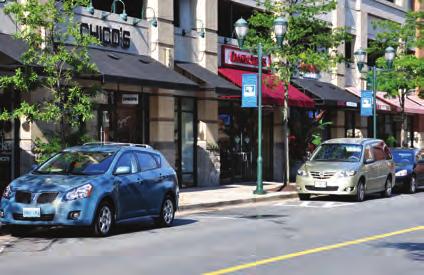
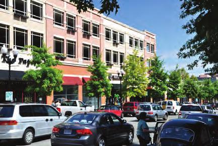
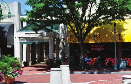
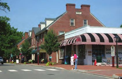
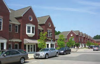
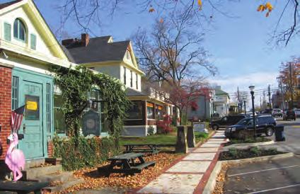
41 DESIGN GUIDELINES FOR CENTERS 25 DESIGN GUIDELINES FOR CENTERS To build upon and further describe the intent of the Growth Framework, design guidelines for its key component centers are presented in this chapter. The guidelines describe the physical characteristics of centers and the implications of design and planning on the public realm. Their purpose is to coordinate the design direction of private development proposals (i.e., new housing projects, shopping center development, etc.) with public infrastructure investment (i.e., streets, sidewalks, parks and trails, etc.) in order to foster the creation of lively, pedestrian-oriented, and economically viable places where Floyds Fork Area residents and visitors can live, work, and play. Consistent with the Growth Framework, the design guidelines encourage compact, mixed-use development in strategic locations to protect the integrity of rural character and natural resources found throughout the Floyds Fork area. The intent of the design guidelines for centers is to supplement or reinforce existing regulation already in place. The Land Development Code (LDC) provides some design standards for regional and town center types. However, design standards for village centers and activity centers within the neighborhood form district are lacking. Chapter 5 of the LCD does describe general standards for various form district components such as buildings and streets, but these aren t consistently applied or necessarily specific to each form district type. Though the reader will note some overlap and repetition with the standards defined in the LDC, the design guidelines described on the following pages build upon and coordinate these standards in order to provide a complete picture of appropriate center development for the Floyds Fork area. The design guidelines are organized in two parts. Based on best practices in urban design and place-making principles, the first part describes the complete menu of design guidelines conceived to create lively, pedestrian-oriented centers in the Floyds Fork area. The second part applies the guidelines to hypothetical development scenarios or prototype plans for regional, town, and village centers. Generated to illustrate the guidelines only, the prototypes are not based on any specific land area or properties, and they do not necessarily reflect an anticipated intensity of development. Local economic conditions will dictate how centers actually develop over time.
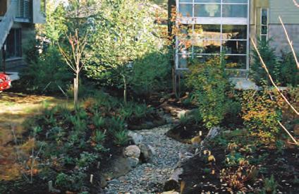
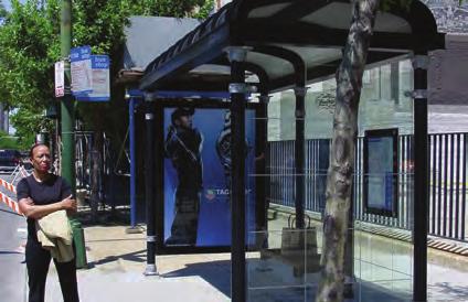
42 26 A FRAMEWORK FOR THE FUTURE The Guidelines Based on the input received from Louisville s residents, development community, and other stakeholders, six general design principles were formulated to inform the definition of more specific design guidelines for centers. Each principle and its related series of design guidelines are described below. The guidelines are illustrated using photographs of exemplary development projects from other places. and are keyed to the corresponding guideline number. Diagramming techniques are also used to illustrate the guidelines where applicable. Subsequent pages in this section (pages 36 to 41) apply the guidelines to prototype plans for regional, town, and village centers. As described above, the prototype plans are not based on any specific land area or properties, and they do not necessarily reflect an anticipated intensity of development. Local economic conditions will dictate how centers actually develop over time. Principle 1: Protect the environment Regional centers should be developed in the most sustainable manner possible to protect natural resources and ecological systems, improve water quality, and reduce carbon footprint. Best practices for low impact site planning, green" building design, alternative storm water management techniques, and provision of transit choice should be integrated into the development of all mixed-use centers. Guidelines to protect the environment in regional centers include: Encourage energy efficient, green building design for all structures within regional centers. Integrate best practices for storm water management into site design and the design of public open spaces. Create green parking areas by integrating pervious paving and shade trees to reduce ambient heating. Enforce the implementation of stream and floodplain buffers to mitigate development impacts related to water quality, flooding, and the Floyds Fork Greenway s natural resources. Integrate transit (i.e., regular bus service, bus rapid transit) to encourage alternative transportation choices between and among the downtown and other centers. At least two transit routes to various destinations should be considered.

43 DESIGN GUIDELINES FOR CENTERS
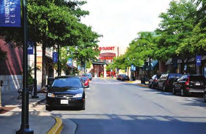
44 28 A FRAMEWORK FOR THE FUTURE Principle 2: Incorporate buildings and parking appropriate for the context The design of buildings should consider the needs of the pedestrian rather than the vehicle, and respect local architectural vernacular and adjacent context. On-street parking should be encouraged, and on-street parking, should be located behind buildings to encourage the development of a pedestrian-oriented mixed-use center. Guidelines for buildings and parking include: Provide parking at the rear of buildings (both surface parking and structured parking) to maintain sense of scale and street character. Ensure safe pedestrian access to and from parking areas. Design parking garages with façade materials comparable to adjacent buildings. Encourage shared parking among uses. Group buildings along both sides of the street to form a public street space defined by walls. Locate clearly identifiable building entrances at corners and at regular intervals along street frontages. Encourage 50% ground floor transparency along commercial streets to avoid long, blank walls along street frontages. Incorporate appropriate building size and mass to fit the center scale: Regional Centers Commercial building floor space should be equal or greater than 400,000 square feet to serve a market area of 100,000 or more in population. Big box retail uses should generally be discouraged, though permissible if integrated into a Main Street or similar organizing element. Building height should generally be limited to five stories or fewer, though buildings up to 150 feet in height (approximately 15 stories) is permissible. Residential, office, hotel, and a mix thereof are suitable uses within taller buildings. Town Centers Commercial building floor space should be between 100,000 and 400,000 square feet. Big box retail uses should generally be discouraged, though permissible if integrated into a Main Street or similar organizing element. Building height should generally be limited to five stories or fewer. Village Centers Commercial building floor space should be 150,000 square feet or less. The maximum single-building square footage should not exceed 35,000 sf; big box retail uses are therefore discouraged. Building height should be limited to three stories or fewer.
45 DESIGN GUIDELINES FOR CENTERS 29 Pedestrian Access to Parking
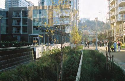
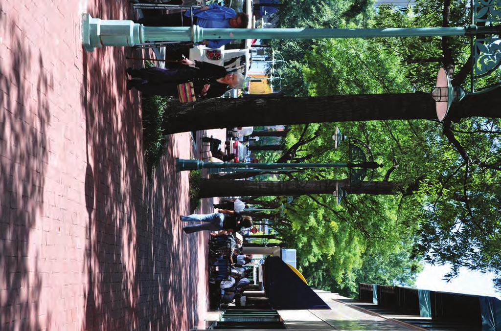
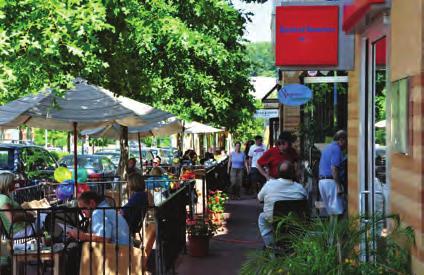
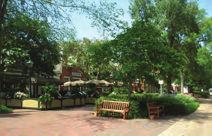
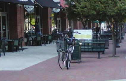
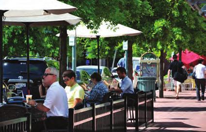
46 30 A FRAMEWORK FOR THE FUTURE Principle 3: Provide pedestrian-friendly streetscapes Streetscapes should be pedestrian-oriented and incorporate a wide variety of amenities such as street trees for shade, benches, and bike racks. Where appropriate, sidewalks should be sufficiently sized to accommodate the free movement of pedestrians, integrate sidewalk cafes, and foster vibrant street life. Guidelines for pedestrian-friendly streetscapes are described below Provide a sidewalk system that connects public streets, parking, and building entrances to the surrounding neighborhoods. Establish zones for pedestrian movement, street furniture, and cafes. Provide street trees for continuous canopy coverage. Provide bicycle racks near building entrances and covered bus shelters where appropriate. Provide pedestrian crosswalks at major intersections. Crosswalk paving surfaces should be distinguished from driving surfaces.

47 DESIGN GUIDELINES FOR CENTERS
48 32 A FRAMEWORK FOR THE FUTURE Principle 4: Integrate connected street and appropriately sized blocks Regional centers should incorporate an interconnected network of streets that enables the efficient movement of pedestrians, bicyclists, motorists, and bus riders of all ages and abilities. Streets should connect to existing roadway infrastructure to facilitate access from adjacent neighborhoods. Blocks should be appropriately sized to accommodate the desired scale and character of development to create a pedestrian-oriented, mixed-use center. The guidelines for streets and blocks are: Establish a connected hierarchy of primary, secondary, and tertiary streets. Ensure street design accommodates two-way traffic. Establish a system of alleyways to separate intensities of use and provide rear access. Connect alleys to the established street hierarchy. Establish street connections to adjacent neighborhoods. Connect to adjacent existing streets where feasible (not illustrated). Create an internal street system for lots greater than 2 ½ acres and connect to establsihed street hierarchy. Enforce and expand Louisville Metro s complete streets policy to implement complete streets througout centers. Complete streets facilitate the safe and efficient movement of pedestrians, bikers, bus riders, and automobiles. Encourage a quality pedestrian environment by establishing maximum block sizes. A single block face should not exceed 600 feet in length; 300 feet is preferred in village centers. Smaller block faces are encouraged as building program permits to encourage a pedestrian-orientation througout centers. Integrate frontage roads parallel to major thoroughfares (major arterials) where feasible. Frontage roads separate regional from local traffic, eliminate the need for multiple curb cuts, and provide a pedestrian-friendly setting for adjacent buildings. Frontage roads should accommodate one-way traffic in the same direction as through traffic on the cooresponding major arterial. Frontage roads should also incorporate parallel or diagonal parking where possible. Frontage roads should only be integrated into town centers when necessary to maintain the center s pedestrian character and free movement of vehicular traffic. This guideline is not applicable to village centers.


49 DESIGN GUIDELINES FOR CENTERS 33 Primary Road Secondary Raod Tertiary Road Development area greater than 2 ½ acres Internal Street Adjacent Development see section at left Regional Center Development Major Arterial Median Frontage Road Sidewalk Major Arterial Median Frontage Road
50 34 A FRAMEWORK FOR THE FUTURE Principle 5: Incorporate parks, plazas, and trails Centers should integrate an interconnected network of parks and open spaces to serve the recreational needs of adjacent residents, foster social interactions, provide habitat for wildlife, and integrate natural systems. Trail linkages to nearby recreational resources and the Louisville Loop are encouraged. The specific guidelines to incorporate parks, plazas, and trails within regional centers include: Provide parks or plazas within an easy 5-minute (1/4-mile) walk of residential areas (not illustrated). Where feasible, create a trail system that connects to the Louisville Loop and other park resources. Link trails to commercial nodes within the regional center, and link regional centers to other types of centers throughout the Floyds Fork area. Provide community gathering places at the entrances of public buildings and venues (theaters, cinemas, community centers, schools, libraries, etc.). Ensure adequate space is provided to accommodate public events and festivals. Group buildings to form distinctive public spaces.
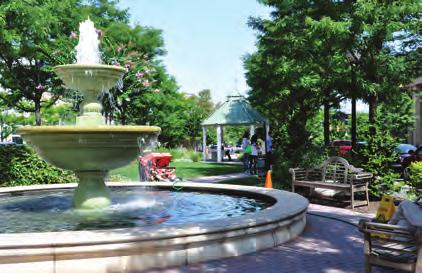
51 DESIGN GUIDELINES FOR CENTERS Public Buildings Community Gathering Space
52 36 A FRAMEWORK FOR THE FUTURE Principle 6: Integrate a mix of land uses A mix of land uses supported by existing, local market conditions should be encouraged to provide a wide range of living, shopping, entertainment, and employment opportunities for area residents. The mix and extent of uses should be appropriate for the designated center scale and respect adjacent neighborhood context. Guidelines for land use are: 30 Encourage a mix of complementary uses. Appropriate uses within regional centers include: Retail uses such as national chain retailers, general shopping venues, entertainment uses, restaurants and cafes, and other convenience retail. Specialty shops like antique dealers, small hospitality facilities (i.e., bed and breakfast) add unique character. Office uses located in single use or mixed-use structures. Civic uses such as schools, community centers, libraries, post offices, and emergency services stations. Residential uses including high-density multi-family, medium density town homes, and lower density single-family detached homes. Public open space and recreational amenities such as parks, plazas, and squares Transition higher density core development to lower density surrounding uses. Other than high-rise towers, buildings or groupings of buildings should gradually step to avoid stark contrast in adjacent building height (not illustrated). Limit free-standing auto-oriented uses (pad sites) to 15% of the mixed-use area. These uses should generally be located only at the periphery of the commercial core along major thoroughfares. Ensure that all buildings on major thoroughfares are connected to both an internal street and sidewalk system. This guideline is not applicable to town and village centers (pad sites should be discouraged).


53 DESIGN GUIDELINES FOR CENTERS Pad Sites Internal Street Sidewalk System Major Thoroughfare 30 32
54 38 A FRAMEWORK FOR THE FUTURE Regional Center Prototype Regional centers serve much of the retail, commercial services, entertainment, and employment needs of the Floyds Fork area. A focal point for surrounding neighborhoods of Floyds Fork and beyond, regional centers are defined as compact areas with a mixture of intense land uses developed around an identifiable commercial core consisting of a mixed-use Main Street or public open space as its primary organizing element. To facilitate regional access, regional centers should be located along major thoroughfares within easy access to major highway interchanges. As indicated in the Growth Framework (see Figure 2.7), the Floyds Fork Area Study identifies one potential regional center at the interchange of I-265 and Bardstown Road. The need for additional regional centers may be identified in the long term as local economic conditions allow. However, additional regional centers should be located west of the Floyds Fork stream valley and as close to the I-265 corridor as possible in order to maintain the desired rural character throughout the rest of the Floyds Fork area. center s periphery. Parking should be accommodated in surface parking lots and structured parking where feasible. Appropriate for office or residential towers, the permissible building height is to a maximum of 150 feet (approximately 15 stories), though buildings five stories or fewer are encouraged. Open space and trail connections should be incorporated into town center design where feasible. Developed according to the description above, a prototype plan for regional centers is shown at right. The intent of the plan is to conceptually illustrate the application of the guidelines for centers to the regional center type. The plan is not specific to any particular land area or properties, and does not reflect an anticipated intensity of development. Local economic conditions will dictate how centers actually develop over time. The largest of the center types, regional centers should incorporate a very wide range of land uses to create a lively eighteen-hour destination for the surrounding region s residents, visitors, and employees. Regional centers should include: retail, office, civic, residential, and open space uses. Consistent with the development guidelines described in the LDC, the commercial floor space in regional centers should be greater than 400,000 square feet to serve a regional market area of 100,000 or more in population. To maintain a quality pedestrian-environment and development character, proposed big box retail uses should be integrated into a pedestrian-friendly Main Street. Autooriented retail uses (i.e., pad sites) should be located along major arterials only, and integrated along a parallel frontage road. High density residential uses should surround the commercial core with lower density residential uses at the
 at entrance of public building Pad sites oritneted to frontage road and integrated with pedestrian circulation network Regional centers located within")
55 DESIGN GUIDELINES FOR CENTERS: REGIONAL CENTERS 39 Big Box retail uses integrated into pedestrian-friendly, mixed-use Main Street Mixed-use Main Street as organizing element for commercial core Public gathering space (park or plaza) at entrance of public building Pad sites oritneted to frontage road and integrated with pedestrian circulation network Regional centers located within convenient access of highway interchange Frontage road along major thoroughfare at commercial development Vehicular and pedestrian connections to adjacent development Structured and surface parking located behind buildings Commercial block faces 600 or less in length Integrated civic structures such as schools, libraries, and community centers Multi-family residential around commercial core as transition to lower-density neighborhoods Park as organizing element for multi-family residential development Storm water management integrated into public spaces Interconnected street and sidewalk network Street trees provide continuous canopy coverage *The following illustration provides a graphic example of typical mass and scale of a village/ town/regional center. This graphic is meant to display general concepts related to pedestrian and transit oriented development. This image does not constitute a specific regulatory control, but provides a general guide for development patterns within the study area. Figure 3.1: Regional Center Prototype* Low Density Residential Medium Density Residential Multi-Family Residential Commercial (retail and office) Civic Parks and Open Space feet
56 40 A FRAMEWORK FOR THE FUTURE Town Center Prototype Serving as the focal point for surrounding neighborhoods and incorporated areas, town centers are defined as compact areas with a mixture of moderately intense uses developed around an identifiable commercial core consisting of a mixed-use Main Street as its primary organizing element. Town centers should be located at historic crossroads or at the intersection of major thoroughfares and collector roadways with strong, direct connections to surrounding neighborhoods. Adjacency to highway interchanges is permissible if local market conditions cannot support the larger regional center type. As indicated in the Growth Framework (see Figure 2.7), the Floyds Fork Area Study identifies one potential town center at Billtown Road near I-265. The need for additional town centers may be identified in the long term as local economic conditions allow. character. Town centers within close proximity to the Floyds Fork Greenway should incorporate open space and trail connections to the Greenway and Louisville Loop Trail system where feasible. Developed according to the description above, a prototype plan for town centers is shown at right. The intent of the plan is to conceptually illustrate the application of the guidelines for centers to the town center type. The plan is not specific to any particular land area or properties, and does not reflect an anticipated intensity of development. Local economic conditions will dictate how centers actually develop over time. Similar to regional centers, town centers should incorporate a wide range of uses to create a lively destination for Floyds Fork area residents and visitors. Appropriate uses within town centers include retail, office, civic, residential, and open space. Consistent with the development standards described in the LDC (and as illustrated in Figure 3.2), commercial floor space should be limited to between 100,000 and 400,000 square feet in order to serve a market area of 25,000 to 75,000 in population. Big box retail uses should generally be discouraged in town centers, and higher density residential uses should surround the commercial core with lower density residential uses at the center s periphery. Buildings five stories or fewer are encouraged in town centers. Parking should typically be accommodated in surface parking lots, though structured parking is permitted where feasible and necessary to maintain a pedestrian-oriented, Main Street

57 DESIGN GUIDELINES FOR CENTERS: TOWN CENTERS 41 Storm water management integrated into public spaces Street trees provide continuous canopy coverage Trail connection to Louisville Loop and Floyds Fork Greenway Interconnected street and sidewalk network Park as organizing element for residential development Integrated civic structures such as schools, libraries, and community centers Big Box retail uses integrated into pedestrian-friendly, mixed-use Main Street Commercial block faces 600 or less in length (400 preferred) Mixed-use Main Street as organizing element for commercial core Public gathering space (park or plaza) at entrance of public building Structured and surface parking located behind buildings Multi-family residential around commercial core as transition to lower-density neighborhoods Vehicular and pedestrian connections to adjacent development Figure 3.2: Town Center Prototype* *The following illustration provides a graphic example of typical mass and scale of a village/ town/regional center. This graphic is meant to display general concepts related to pedestrian and transit oriented development. This image does not constitute a specific regulatory control, but provides a general guide for development patterns within the study area. Low Density Residential Medium Density Residential Multi-Family Residential Commercial (retail and office) Civic Parks and Open Space feet
58 42 A FRAMEWORK FOR THE FUTURE Village Center Prototype Village centers are compact areas with a mixture of relatively low intensity uses developed around an identifiable commercial core consisting of a village green as its organizing element. Consistent with the Floyds Fork area s pre-1940 historic development pattern (e.g. the Village of Fisherville), village centers should be located at historic crossroads or along collector roadways. As indicated in the Growth Framework (see Figure 2.7), the Floyds Fork Area Study identifies two potential village centers: one along Taylorsville Road at the existing Village of Fisherville (not currently designated Village Form District in the LDC), and the second on the east side of Bardstown Road at the future extension of Cooper Chapel Road. The need for additional village centers may be identified in the long term as local economic conditions allow. to the Floyds Fork Greenway should incorporate open space and trail connections to the Greenway and Louisville Loop Trail system where feasible. Developed according to the description above, a prototype plan for village centers is shown at right. The intent of the plan is to conceptually illustrate the application of the guidelines for centers to the village center type. The plan is not specific to any particular land area or properties, and does not reflect an anticipated intensity of development. Local economic conditions will dictate how centers actually develop over time. Village centers should incorporate a range of uses compatible with nearby rural neighborhoods. Village centers located within or immediately adjacent to the Floyds Fork Greenway could serve as park gateways or trail heads, with support functions for Greenway users such as bike or canoe rental facilities, fly fishing shops, and small eateries. Appropriate uses within village centers include retail, office, civic, residential, and public open space. To encourage a development character suitable for village centers, the maximum single building footprint should not exceed 35,000 square feet. Big box retail uses, which generally exceed 35,000 square feet, are therefore discouraged in village centers. Higher density residential uses should surround the commercial core with lower density residential uses at the center s periphery. Parking should be accommodated in surface parking lots located in the rear of buildings to maintain a pedestrian-oriented village character. Building design should be limited to three stories or fewer and reflect a traditional pattern of development and local architectural vernacular. Village centers within close proximity
 Surface parking located")
59 DESIGN GUIDELINES FOR CENTERS: VILLAGE CENTERS 43 Trail head to Louisville Loop and Floyds Fork Greenway Road way separation between village center and the Floyds Fork Greenway Interconnected street and sidewalk network Multi-family residential around commercial core as transition to lower-density neighborhoods Commercial block faces 600 or less in length (400 preferred) Surface parking located behind buildings Public gathering space at village center s heart Street trees provide continuous canopy coverage Integrated civic structure such as library, community center, etc. Park as organizing element for residential development Vehicular and pedestrian connections to adjacent rural neighborhoods Storm water management integrated into public spaces Figure 3.3: Village Center Prototype* *The following illustration provides a graphic example of typical mass and scale of a village/ town/regional center. This graphic is meant to display general concepts related to pedestrian and transit oriented development. This image does not constitute a specific regulatory control, but provides a general guide for development patterns within the study area. Low Density Residential Medium Density Residential Multi-Family Residential Commercial (retail and office) Civic Parks and Open Space feet
The Floyds Fork Area Study A Framework for Growth
 The Floyds Fork Area Study A Framework for Growth Planning Committee 7/8/10 City of Parks 2 Growth Pattern REZONINGS (1976 2007) 1976 1983 1984 1991 1992 1999 2000 2007 1976-1983 3 Growth Pattern REZONINGS
The Floyds Fork Area Study A Framework for Growth
 The Floyds Fork Area Study A Framework for Growth 2 21 st Century Parks Master Plan: The Fork 3 Neighborhood Development Area Policy Recommendations 1. Create incentives to promote infill of existing development
Floyds Fork Area Study Project Overview, Suitability Analysis, & Form Districts July 29, title
 Floyds Fork Area Study Project Overview, Suitability Analysis, & Form Districts July 29, 2008 Agenda Floyds Fork Area Study Project overview and purpose Process and schedule Ongoing initiatives Floyds
The Floyds Fork Area Plan
 The Floyds Fork Area Plan Growth Framework and Design Principles Presented by: Wallace Roberts & Todd, LLC March 24, 2009 Ted Wathen / Quadrant Agenda Project overview and purpose Growth framework Design
BROOKHILL NEIGHBORHOOD MODEL ZONING MAP AMENDMENT PREFACE TO APPLICATION
 BROOKHILL NEIGHBORHOOD MODEL ZONING MAP AMENDMENT PREFACE TO APPLICATION June 15, 2015 Revised: August 1, 2016 I. VISION Brookhill is a proposed community based upon the principles of Albemarle County
3. VISION AND GOALS. Vision Statement. Goals, Objectives and Policies
 Vision Statement Queen Creek s interconnected network of parks, trails, open spaces and recreation opportunities provide safe and diverse activities and programs that sustain its unique, small town, equestrian
Gold Line Bus Rapid Transit Transit Oriented Development (BRTOD) Helmo Station Area Plan
 Helmo Station Area Plan") Appendix F Gold Line Bus Rapid Transit Transit Oriented Development (BRTOD) Helmo Station Area Plan Introduction and Purpose of the Plan The Gold Line Bus Rapid Transit facility is an eleven-mile dedicated
Appendix F Gold Line Bus Rapid Transit Transit Oriented Development (BRTOD) Helmo Station Area Plan Introduction and Purpose of the Plan The Gold Line Bus Rapid Transit facility is an eleven-mile dedicated
The transportation system in a community is an
 7 TRANSPORTATION The transportation system in a community is an important factor contributing to the quality of life of the residents. Without a sound transportation system to bring both goods and patrons
CHAPTER 7: VISION AND ACTION STATEMENTS. Noble 2025 Vision Statement
 CHAPTER 7: VISION AND ACTION STATEMENTS This chapter presents the vision, policy and action statements that transform the comprehensive planning study, an analysis of Noble s past, future trends and community
Rural Land Use Designations Kittitas County December 6, 2007 Draft
 KITTITAS COUNTY COMMUNITY DEVELOPMENT SERVICES 411 N. Ruby St., Suite 2, Ellensburg, WA 98926 CDS@CO.KITTITAS.WA.US Office (509) 962-7506 Fax (509) 962-7682 Rural Land Use Designations Kittitas County
IMPLEMENTATION STRATEGIES. In This Chapter. Goals & Strategies 182 Project List 183 Future Land Use 186 CHAPTER 11 IMPLEMENTATION STRATEGIES
 In This Chapter Goals & Strategies 182 Project List 183 Future Land Use 186 11 IMPLEMENTATION STRATEGIES NORTH AUGUSTA, SC 2017 COMPREHENSIVE PLAN 179 Individual commitment to a group effort that is what
Ten Mile Creek Planning Area
 PLANNING AREA POLICIES TEN MILE CREEK Ten Mile Creek Planning Area Location and Context The Ten Mile Creek Planning Area ( Ten Mile Creek area ) is located south of the current Boise AOCI, generally south
Executive Summary. NY 7 / NY 2 Corridor
 Executive Summary NY 7 / NY 2 Corridor Transportation and Land Use Study December 2005 Prepared for: Town of Colonie Capital District Transportation Committee Prepared by: Introduction: Land use decisions
Secrest Short Cut and Monroe Expressway Small Area Plan AUGUST 29, 2018
 Secrest Short Cut and Monroe Expressway Small Area Plan AUGUST 29, 2018 Background and Process Monroe Expressway will be open by the end of 2018 Union County and Indian Trail identified a need to revisit
Chapter 6: Community Character
 Chapter 6: Community Character The term "community character" covers a broad spectrum of concerns. First and foremost, community character is a visual concept. In Long Grove, however, community character
CITY OF PUYALLUP. Background. Development Services
 CITY OF PUYALLUP Development Services 333 South Meridian Puyallup WA 98371 To: City Council From: Katie Baker, AICP, Planning Division Re: South Hill Neighborhood Plan Adoption Date: (Meeting date: February
E. RURAL COMMERCIAL/INDUSTRIAL PARK MODEL
 E. RURAL COMMERCIAL/INDUSTRIAL PARK MODEL 1. PURPOSE The purpose of the Rural Commerce/Industrial Park Model is to provide parameters within which a grouping of business buildings with parking, loading
COMMUNITY DESIGN. GOAL: Create livable and attractive communities. Intent
 COMMUNITY DESIGN Intent An attractive, well-designed County will attract quality development, instill civic pride, improve the visual character of the community, and create a strong, positive image for
SHEFFIELD PARK Paulding County, GA DRI #588
 SHEFFIELD PARK Paulding County, GA DRI #588 Supplemental Information for RDC s DRI (Form 2) Review August 16, 2004 Prepared for: Mr. David Howerin Coosa Valley RDC 1 Jackson Hill Drive Rome, GA 30161 P.O.
EXECUTIVE SUMMARY DRAFT CHAPTER 1 INTRODUCTION EXECUTIVE SUMMARY
 CHAPTER 1 EXECUTIVE SUMMARY INTRODUCTION Through the joint efforts of the City of Tulsa planning staff and the Land Services division of Indian Nations Council of Governments (INCOG), the Berryhill Land
ARLINGTON COUNTY, VIRGINIA
 ARLINGTON COUNTY, VIRGINIA County Board Agenda Item Meeting October 15, 2005 DATE: September 28, 2005 SUBJECT: Request to Advertise the adoption of the 2005 Clarendon Sector Plan C. M. RECOMMENDATION:
Selected Area Study. Vision Plan Draft
 East Polk County Selected Area Study Draft 10.30.08 Contents Guiding Principles...4 Context Conclusions...5 Current Context...8 Scenarios...9 Scenario: Status Quo...10 Scenario: Connected & Directed Growth...12
Corridor Vision. 1Pursue Minnehaha-Hiawatha Community Works Project. Mission of Hennepin County Community Works Program
 1Pursue Minnehaha-Hiawatha Community Works Project Minnehaha-Hiawatha Community Works is a project within the Hennepin Community Works (HCW) program. The mission of the HCW program is to enhance how the
CHAPTER 8 ISSUES, CONCERNS, CONSTRAINTS AND OPPORTUNITIES
 CHAPTER 8 ISSUES, CONCERNS, CONSTRAINTS AND OPPORTUNITIES Introduction This River Conservation Plan was developed during a time of tremendous activity and effort in planning the transformation of the Delaware
The Illinois Department of Transportation and Lake County Division of Transportation. Route 173, including the Millburn Bypass
 The Illinois Department of Transportation and Lake County Division of Transportation welcome you to this Public Hearing for U.S. Route 45 from Illinois Route 132 to Illinois Route 173, including the Millburn
CHAPTER 7: Transportation, Mobility and Circulation
 AGLE AREA COMMUNITY Plan CHAPTER 7 CHAPTER 7: Transportation, Mobility and Circulation Transportation, Mobility and Circulation The purpose of the Transportation, Mobility and Circulation Chapter is to
Making TOD Work in the Heart of Suburban Sprawl
 Making TOD Work in the Heart of Suburban Sprawl Rocky Mountain Land Use Institute March 6, 2009 Speakers Ben Herman, FAICP, Principal Clarion Associates Darcie White, AICP, Principal Clarion Associates
Implementation Guide Comprehensive Plan City of Allen
 Implementation Guide 2030 Comprehensive Plan City of Allen DRAFT 2015 Implementation Guide Allen 2030 Comprehensive Plan INTRODUCTION The Comprehensive Plan serves as a guide for the growth and development
IMPLEMENTING SOMERSET COUNTY S INVESTMENT FRAMEWORK
 IMPLEMENTING SOMERSET COUNTY S INVESTMENT FRAMEWORK SMART CONSERVATION THROUGH SMART GROWTH NJ LAND CONSERVATION RALLY March 22, 2014 Laurette Kratina, PP, AICP, Supervising Planner Somerset County Planning
2.0 AREA PLANS. Lakeside Business District. Lakeside Business District Land Use Categories:
 Lakeside Business District Lakeside Business District Land Use Categories: Campus Commercial Campus Commercial means a mixture of uses which includes corporate offices, office parks, hotels, commercial,
AWH REPORT OF THE PLANNING AND DEVELOPMENT DEPARTMENT FOR APPLICATION FOR REZONING ORDINANCE TO PLANNED UNIT DEVELOPMENT
 AWH REPORT OF THE PLANNING AND DEVELOPMENT DEPARTMENT FOR APPLICATION FOR REZONING ORDINANCE TO PLANNED UNIT DEVELOPMENT MAY 8, 2014 The Planning and Development Department hereby forwards to the Planning
ARTICLE 6: Special and Planned Development Districts
 ARTICLE 6: Special and Planned Development Districts 6-10 Traditional Neighborhood Development (TND) District 6-10.10 Purpose and Intent The Traditional Neighborhood Development (TND) District provides
Executive Summary. The Mebane CLP is not a regulatory document, but is intended to guide land development decisions. The plan includes:
 Executive Summary P URPOSE AND O RGANIZATION OF THE P LAN The City of Mebane, with input from citizens and an appointed CLP Advisory Committee, adopted Mebane by Design, a Comprehensive Land Development
Description of Preferred Alternative
 Chapter 2 Description of Preferred Alternative 2.1 Introduction This chapter of the programmatic Sammamish Town Center Sub-area Plan Final EIS provides a more detailed description of the Preferred Alternative
NORTH-SOUTH CORRIDOR STUDY EXECUTIVE SUMMARY. Executive Summary
 Executive Summary Background As congestion continues to affect mobility in the region, the Ozarks Transportation Organization (OTO) is particularly concerned with traffic movement. The North-South Corridor
RECREATION, OPEN SPACE AND GREENWAYS ELEMENT GOALS, OBJECTIVES, AND POLICIES
 RECREATION, OPEN SPACE AND GREENWAYS ELEMENT GOALS, OBJECTIVES, AND POLICIES GOAL R-1: DEVELOP A RECREATION, OPEN SPACE AND GREENWAYS SYSTEM AS AN INTEGRAL COMPONENT OF AN OVERALL, COUNTY-WIDE ECONOMIC
9 th Street Sub Area Plan
 9 th Street Sub Area Plan In the 1990 s, when the Township prepared the last Master Plan, the 9 th Street corridor was studied as part of a larger 9 th Street Focus Area that included the West Main Street
Outer Congress Street Land Use
 Outer Congress Street Land Use Outer Congress Street, with its historic residential district, natural resource and open space amenities, trail network, and proximity to major transportation infrastructure
A. WHAT IS A GENERAL PLAN?
 I. Introduction A. WHAT IS A GENERAL PLAN? A general plan is the planning guideline for the future of a city. It contains goals and policies which regulate urban development, the protection of the natural
Hockessin Community Redevelopment Plan
 Hockessin Community Redevelopment Plan 3.1 Introduction The Community Redevelopment Plan for the Village of Hockessin is the result of the people s vision for a distinct village center that serves as the
CHAPTER 4 FUTURE LAND USE AND URBAN SERVICES DISTRICTS
 CHAPTER 4 FUTURE LAND USE AND URBAN SERVICES DISTRICTS Introduction This chapter discusses how Benzie County should grow and change in the future. A community can grow and change in many different ways.
Elm Fork Land Use. Trinity River Corridor Project Committee May 13, 2013
 Elm Fork Land Use Trinity River Corridor Project Committee May 13, 2013 Purpose Discuss Trinity River planned Land Use and Appropriate Compatible Uses, particularly with respect to the Elm Fork Area 2
Midtown Greenway Land Use and Development Plan Executive Summary
 Midtown Greenway Land Use and Development Plan Executive Summary Introduction The Midtown Greenway Land Use and Development Plan sets policy direction for land use and development in the Midtown Greenway
Planning Districts INTRODUCTION
 INTRODUCTION To facilitate detailed examination of development prospects for all areas of the community, Delano has been divided into 14 planning districts. The location of these planning districts is
Chapter 5: Natural Resources and Environment
 NATURAL RESOURCES AND ENVIRONMENT 5-1 5 Chapter 5: Natural Resources and Environment BACKGROUND AND INTENT Urban expansion represents the greatest risk for the future degradation of existing natural areas,
CITY OF COLWICH COMPREHENSIVE PLAN LAND USE LAND USE 1
 LAND USE LAND USE 1 WHAT YOU WILL FIND IN THIS CHAPTER: Discussion of today s conditions and tomorrow s projections Discussion of challenges and opportunities Discussion of the environmental quality goals,
POCKET COMMUNITY PLAN
 POCKET COMMUNITY PLAN Part Three : COMMUNITY PLAN AREAS AND SPECIAL STUDY AREAS CONTENTS Community Location... 3-P-3 Community Vision... 3-P-4 Community Profile... 3-P-4 Community Issues... 3-P-6 Land
THAT the attached Terms of Reference for the Thornhill Centre Street Study be approved.
 COMMITTEE OF THE WHOLE AUGUST 18, 2003 THORNHILL CENTRE STREET STUDY PLANNING FILE: 15.92 Recommendation The Commissioner of Planning recommends: THAT the attached Terms of Reference for the Thornhill
The West Vaughan Employment Area Secondary Plan Policies
 Part 2: The West Vaughan Employment Area Secondary Plan Policies 2.1 General Policies It is the policy of Council: 2.1.1. That the West Vaughan Employment Area (the WVEA), identified on Schedule 1, will
Beatties Ford Road & Mt. Holly-Huntersville Road Small Area Plan
 Beatties Ford Road & Mt. Holly-Huntersville Road Small Area Plan Town of Huntersville October 2005 Town of Huntersville Planning Department 101 Huntersville Concord Road Post Office Box 664 Huntersville,
Staff Report and Recommendation
 Community Planning and Development Planning Services 201 W. Colfax Ave., Dept. 205 Denver, CO 80202 p: 720.865.2915 f: 720.865.3052 www.denvergov.org/cpd TO: City Council Neighborhoods and Planning Committee
Urban Planning and Land Use
 Urban Planning and Land Use 701 North 7 th Street, Room 423 Phone: (913) 573-5750 Kansas City, Kansas 66101 Fax: (913) 573-5796 Email: planninginfo@wycokck.org www.wycokck.org/planning To: From: City Planning
CITY OF CHARLOTTESVILLE, VIRGINIA CITY COUNCIL AGENDA
 CITY OF CHARLOTTESVILLE, VIRGINIA CITY COUNCIL AGENDA Agenda Date: December 16, 2013 Action Required: Adoption of Resolution Presenter: Staff Contacts: Title: James E. Tolbert, AICP, Director of NDS James
COLVER ROAD INDUSTRIAL CONCEPT PLAN
 COLVER ROAD INDUSTRIAL CONCEPT PLAN A CONCEPTUAL LAND USE AND TRANSPORTATION PLAN FOR TA-4 AN URBAN RESERVE AREA OF THE CITY TALENT City of Talent Adopted by City Council Resolution No., June, 2015 PART
Town Center (part of the Comprehensive Plan)
") Town Center (part of the Comprehensive Plan) Mercer Island Town Center Looking North (2014) In 1994, a year-long process culminated in a set of design guidelines and code requirements for the Town Center
Town Center (part of the Comprehensive Plan) Mercer Island Town Center Looking North (2014) In 1994, a year-long process culminated in a set of design guidelines and code requirements for the Town Center
Silver Line CPAM UPDATE. Transportation and Land Use Committee October 14, 2016
 Silver Line CPAM UPDATE Transportation and Land Use Committee October 14, 2016 Purpose Recap Project History and Map Changes Provide Overview of CPAM Components Discuss Transportation Impacts Discuss Fiscal
Proposed Comprehensive Plan Strategies DRAFT for discussion June 28, 2017
 Proposed Comprehensive Plan Strategies DRAFT for discussion June 28, 2017 Land Use Rural Areas Refine the Farm and Forest area (FF) Update FF boundaries to account for existing lots less than five acres
Baumgarten MPUD. Exhibit 3 Evaluation Criteria
 Pursuant to LDC subsections 10.02.13 B, 10.02.08 F and Chapter 3 G. of the Administrative Code, staff s analysis and recommendation to the Planning Commission, and the Planning Commission s recommendation
CITY CLERK. Parkland Acquisition Strategic Directions Report (All Wards)
") CITY CLERK Clause embodied in Report No. 10 of the, as adopted by the Council of the City of Toronto at its meeting held on November 6, 7 and 8, 2001. 10 Parkland Acquisition Strategic Directions Report
CITY CLERK Clause embodied in Report No. 10 of the, as adopted by the Council of the City of Toronto at its meeting held on November 6, 7 and 8, 2001. 10 Parkland Acquisition Strategic Directions Report
38 Queen s University Campus Master Plan Part 1
 38 Queen s University Campus Master Plan Part 1 46 The Campus at the City Scale Chapter 4 The Campus at the City Scale 39 Queen s is an urban University centrally located in Kingston. Decisions made by
LAND USE ELEMENT. Purpose. General Goals & Policies
 LAND USE ELEMENT Purpose This Land Use Element contains the goals and policies necessary to support the City s responsibility for managing land resources and guiding development through implementing regulations,
Section 4 BUILDING THE MASTER PLAN
 The Master Plan 33 Section 4 BUILDING THE MASTER PLAN Figure 4:1. A collaborative effort characterized the two design workshops sponsored by DISC to create hypothetical Master Plans for the Towers Property
hermitage town center
 hermitage town center A Community Vision prepared by Strada for The City of Hermitage and The Mercer County Regional Planning Commission January 2007 table of contents introduction 3 design principles
CITY OF TIGARD EXPECTED SERVICE AREA
 CITY OF TIGARD EXPECTED SERVICE AREA City overview / Background Incorporated in 1961, the has experienced rapid growth over the years. This growth can be attributed to many factors, primarily the close
Mendota Heights 2040 Comprehensive Plan Draft Vers
 4 Parks and Trails The City of Mendota Heights boasts a variety of recreational and open space opportunities. Few cities can claim access to regional trails, riverside and lakeside parks, scenic bluffs
9 CITY OF VAUGHAN OFFICIAL PLAN AMENDMENT NO BOCA EAST INVESTMENTS LIMITED
 9 CITY OF VAUGHAN OFFICIAL PLAN AMENDMENT NO. 631 - BOCA EAST INVESTMENTS LIMITED The Planning and Economic Development Committee recommends the adoption of the recommendations contained in the following
The Five Components of the McLoughlin Area Plan
 The Five Components of the McLoughlin Area Plan This documents contains the complete language of the five components of the McLoughlin Area Plan: The Vision Statement The Values The Guiding Principles
7Page 72 CLEMMONS COMMUNITY COMPASS 5 DEVELOPMENT AND GROWTH
 5 Development and Growth WHHAATT DDOOEESS IITT I MMEEAANN TTOO BBEE SSUUSSTTAAI IINNAABBLLEE?? Many communities throughout the U.S. are taking on the challenge of becoming more sustainable. But what exactly
OVERVIEW OF PLANS FOR THE JEFFERSON COUNTY COUNTRYSIDE FARM In the Context of Quality Place Characteristics
 OVERVIEW OF PLANS FOR THE JEFFERSON COUNTY COUNTRYSIDE FARM In the Context of Quality Place Characteristics By Steve Grabow, Professor and Community Development Educator University of Wisconsin-Extension,
Chapter IV: Development Pattern
 Chapter IV: Development Pattern Introduction The 2002 Prince George s County Approved General Plan designates three growth policy tiers Developed, Developing, and Rural as well as three center designations
Chapter 1.0 Introduction
 Chapter 1.0 Introduction 1.1 Background The North Metro commuter rail line is part of the RTD FasTracks regional transit system expansion program to build more than 100 miles of rail transit throughout
Regional Context Statement
 Regional Context Statement REGIONAL CONTEXT STATEMENT 3. REGIONAL CONTEXT STATEMENT In 1995, the Provincial Government passed into law the Growth Strategies Act. The purpose of this provincial initiative
Urban Development Areas Frederick County
 18 Urban Development Areas Frederick County UDA Needs Profile: All UDAs Frederick County, Virginia's northernmost county has two UDA s, surrounded by the City of Winchester and located adjacent to the
Living in Albemarle County s Urban Places
 Living in Albemarle County s Urban Places ALBEMARLE COUNTY, VIRGINIA A Closer Look at Albemarle s Approach to Managing Growth and Creating Quality Urban Environments www.albemarle.org Page 2 Living in
Dwelling Units Max 12 dwelling units per acre/min 8 dwelling units per acre. Development Mix 80% non residential/20% residential
 13. OSTEEN LOCAL PLAN Background: The Osteen Local Plan area is located in southwest Volusia County along the SR 415 corridor between Lemon Bluff Road and Acorn Lake Road and includes 3,990 acres. The
Acknowledgements. Municipal Partners. Neighborhood Partners City of Hurstbourne City of Hurstbourne Acres Old Dorsey Place
 Acknowledgements Municipal Partners Metro Louisville: Julie Raque Adams, District 18 Councilwoman City of Hurstbourne City of Bellemeade Neighborhood Partners City of Hurstbourne City of Hurstbourne Acres
REQUEST FOR QUALIFICATIONS
 REQUEST FOR QUALIFICATIONS VILLAGE OF HAMBURG COMPREHENSIVE ZONING/LAND USE REGULATIONS UPDATE Prepared By: Village of Hamburg 100 Main Street Hamburg, New York 14075 Village of Hamburg RFQ Page 1 of 10
STATEMENT OF JUSTIFICATION CLARKSBURG PREMIUM OUTLETS AT CABIN BRANCH NORTH DISTRICT, PHASE
 STATEMENT OF JUSTIFICATION CLARKSBURG PREMIUM OUTLETS AT CABIN BRANCH NORTH DISTRICT, PHASE 1 Southwest Corner of Clarksburg Road and Interstate-270 Clarksburg, Maryland Application for Site Plan #820140160
Comprehensive Development Guide
 INDUSTRIAL ELEMENT Comprehensive Development Guide 1 Industrial Element 7.1 Hardin County Industrial Overview BG PKWY Fort Knox Industrial Corridor Comprised of 11 parcels totaling 720 acres of land 68
Chapter 1 - General Design Guidelines CHAPTER 1 GENERAL DESIGN GUIDELINES
 CHAPTER 1 GENERAL DESIGN GUIDELINES 1.0 INTRODUCTION This Publication has been developed to provide current, uniform procedures and guidelines for the application and design of safe, convenient, efficient
Robbinsdale LRT Station. CDI Development Guidelines. August Overview
 Robbinsdale LRT Station August 2018 Overview The City of Robbinsdale may have the coolest opportunity site along the 13 mile stretch of the Bottineau LRT corridor / Blue Line extension. Located a block
T H R E E Previous Studies
 T H R E E Previous Studies The root of all my good work is an early respct for, regard and enjoyment of the scenery. - Frederick Law Olmsted Chapter Three: Previous Studies THREE T he City of Louisville
CHAPTER 1. Ms. Guajardo s Class - Central Elementary CH 1 1
 INTRODUCTION CHAPTER 1 Ms. Guajardo s Class - Central Elementary CH 1 1 1.1 SETTING South Centre City is a linear corridor south of Downtown Escondido paralleling Centre City Parkway and South Escondido
Scope of Services. River Oaks Boulevard (SH 183) Corridor Master Plan
 Corridor Master Plan") Scope of Services River Oaks Boulevard (SH 183) Corridor Master Plan PROJECT AREA The project area consists of the River Oaks Boulevard (SH 183) corridor bounded by SH 199 at the northern end and the Trinity
Scope of Services River Oaks Boulevard (SH 183) Corridor Master Plan PROJECT AREA The project area consists of the River Oaks Boulevard (SH 183) corridor bounded by SH 199 at the northern end and the Trinity
4.1.3 LAND USE CATEGORIES
 4.1.3 LAND USE CATEGORIES a. City Center District The City Center District incorporates the existing character and mix of uses in downtown Belmont to encourage redevelopment and new development in keeping
1. Parks & Recreation Neighborhood Parks Community Parks Special Use Sites 2. Open Space 3. Trails
 Appendix A: Park Classifications The intent of parks and recreation classifications is to aid in making acquisition and design decisions for park sites, facilities and the organization of recreation space
Chapter 10 IMPLEMENTATION RECOMMENDATIONS
 Chapter 10 IMPLEMENTATION RECOMMENDATIONS The recommended land use plan presented in the previous chapter provides a design for the attainment of the urban and rural development and open space preservation
FOUR MILE RUN VALLEY WORKING GROUP AND CHARGE
 FOUR MILE RUN VALLEY WORKING GROUP AND CHARGE Adopted April 16, 2016 Amended July 19, 2016 Overview of Integrated Effort The overall goal of the Four Mile Run Valley (4MRV) initiative is to develop a comprehensive
17.11 Establishment of Land Use Districts
 17.11 Establishment of Land Use Districts 17.11.010 Purpose. To promote the health, safety, and general welfare of City residents and those who come to South Salt Lake to work, exchange commerce and recreate.
Review of Opportunity Area C Draft Comprehensive Plan and Draft BOS Follow-On Motions. Special Working Group Meeting March 4, 2015
 Review of Opportunity Area C Draft Comprehensive Plan and Draft BOS Follow-On Motions Special Working Group Meeting March 4, 2015 The slides that follow identify where the draft Comprehensive Plan has
Section 1. Executive Summary
 Executive Summary (This page left blank intentionally) Executive Summary Background Economic growth in southern Leavenworth County over the past decade has been strong. As both the number of business and
Mitchell Ranch South MPUD Application for Master Planned Unit Development Approval Project Narrative. Introduction
 Mitchell Ranch South MPUD Application for Master Planned Unit Development Approval Project Narrative Introduction Mitchell Ranch South is a proposed single family (detached) residential development on
General Location Annex, Rezone & Preliminary Plat Lansdowne Addition, Unit Three
 NEWFOUNDLAND I-5 Agricultural District Subject Site SUNDANCE ANDERSON Single Family Residential CHRISTY PUD Agricultural District Highway Business General Location Annex, Rezone & Preliminary Plat Lansdowne
Cobb County Design Guidelines Mableton Parkway & Veterans Memorial Highway Community Design Workshop January 12, 2017
 Community Design Workshop January 12, 2017 Agenda Opening Remarks / Introductions Scope of Work Existing Conditions Key Issues / Opportunities VPS Summary Draft Vision & Goal Statement Implementation Concepts
3.10 LAND USE SETTING PROJECT SITE EXISTING LAND USE DESIGNATIONS AND ZONING. General Plan Land Use Designations.
 This section of the Draft EIR addresses the existing land uses on and adjacent to the project site and discusses the potential impacts of the proposed project on existing land uses. Key issues addressed
CHARLES PUTMAN CHARLES PUTMAN AND ASSOCIATES, INC
 MEMORANDUM CHARLES PUTMAN & ASSOCIATES, INC. LAND DEVELOPMENT CONSULTANTS PLANNING ZONING PERMITTING 4722 NW Boca Raton Boulevard, Suite C-106 Boca Raton, Florida 33431 Phone: 561/994-6411 FAX: 561/994-0447
Comprehensive Plan ADOPTED APRIL 2014
 Comprehensive Plan ADOPTED APRIL 2014 8 8. Outstanding Recreational & Cultural Opportunities We are proud of our community s parks and recreation system. Our community will ensure that the legacy of our
CHAPTER 12 IMPLEMENTATION
 CHAPTER 12 IMPLEMENTATION The 2010 Town of Denton Comprehensive Plan is intended to capture a vision of the future of Denton. As such, it provides a basis for a wide variety of public and private actions
The following rules shall be used to determine the precise location of any zone boundary shown on the Official Zoning Map of Auburn:
 ARTICLE III. ESTABLISHMENT OF ZONING DISTRICTS Section 300. Establishment of Zoning Districts. The City of Auburn, Alabama is hereby divided into zoning districts of such number and character as are necessary
Existing Transportation System 5-1
 5-1 The Jackson County transportation system is served by several modes of transportation including streets and highways, multi-modal, non-motorized, rail, and aviation. While the focus of the transportation