THE MAPPING OF MAYFIELD HOUSE
|
|
|
- Arline Dennis
- 6 years ago
- Views:
Transcription
1 THE MAPPING OF MAYFIELD HOUSE P E A R I D G E M I L I T A R Y PARK A Community EMPACTS Project Jennifer Canfield, Ted Siebert, Vanessa Fisher Introduction to Geographic Information Paul Lowrey
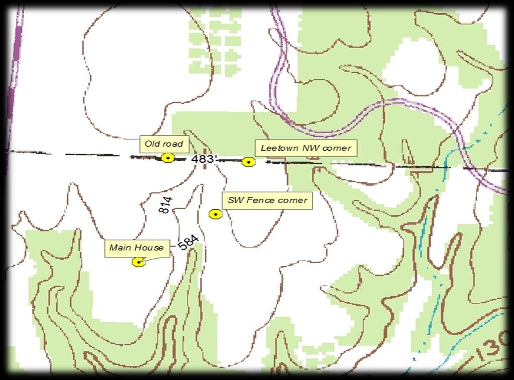
2 INTRODUCTION The focus of this project is creating a map that leads to the Mayfield House in Leetown, AR. With this information will help the Pea Ridge National Military Park by mapping parts of Lee town and showing were the Mayfield house was, so in the future U.S. National Park Service can research the area and learn new information about the Leetown area.

3 MAYFIELD HOUSE 1913
4 A B R I E F H I S T O R Y O F L E E T O W N H A M L E T B Y V I R G I L B E C K The earliest land record I have found for Leetown Hamlet is a deed from 3 September 1851 from Abedingo Shelton to Martha Lee and John W. Lee. Bearss refers to an earlier land patent made to Abedingo Shelton. For roughly ten years Leetown Hamlet was a promising town. It had a school, a church, two Stores, blacksmith shop, and a Masonic Lodge. But the battle of Leetown destroyed the town. What is called the Battle of Leetown did not take Place in Leetown itself, but in a clearing about one half mile to the North. Two Confederate Generals fell during the Battle of Leetown, Major General McCulloch and minutes afterwards Brigadier General McIntosh, the union Army won after a day of hard fighting. After the Battle of Pea Ridge Leetown Hamlet was used as a hospital, by the Union Army, Union troops and Confederate Prisoners were seen at Leetown Hamlet. The best description of Leetown Hamlet at the time of the battle comes from a Union Surgeon. Leetown Hamlet is described to have fifteen to twenty houses, frame and log. The surgeon goes on to say that there was a shortage of water, but Lee creek and Winston spring were known to always have water and with the wet weather should have been running. All the buildings in Leetown Hamlet except the Lee house and the Wix Mayfield House were destroyed between March and November of The way the buildings were destroyed is not know they were destroyed either by Bushwhackers or the Army. I tend to believe it was done by Bushwhackers when they destroyed the Elkhorn Tavern. The Wix Mayfield house burned (if can t find when). The Lee House was still standing at the time the Land became part of the Pea Ridge National Military Park, and for some reason was destroyed. This is a great loss to the History of the Park, because the chimney and front room of the house was there during the Battle of Pea Ridge.
5 A BRIEF HISTORY OF LEETOWN HAMLET The earliest land record I have found for Leetown Hamlet is a deed from 3 September 1851 from Abedingo Shelton to Martha Lee and John W. Lee. Bearss refers to an earlier land patent made to Abedingo Shelton. 1. Deed of Sale from Abedingo Shelton and wife to Martha Lee and John W. Lee, 3 September, 1851, Benton County Arkansas, Deed Book B, Page 169, Benton County Achieves, Rogers, Arkansas. 2. Edwin C. Bearss, Leetown, Elkhorn Tavern Grounds, Federal Earthworks, and Tanyard as of March, 1862, (Pea Ridge, NMP, 1865),80 3. U.S. Department of the Army, the Medical and Surgical History of the War of the Rebellion. Appendix to Part I,(Washington DC, 1875),340.
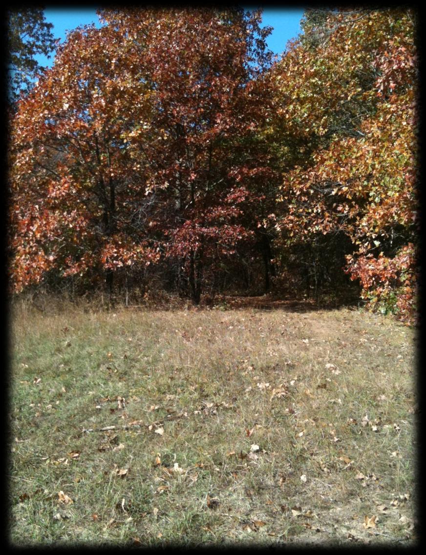
6 PROJECT OVERVIEW Mapping the area in and around the Mayfield house and Leetown to promote historical research in the Pea Ridge Military Park
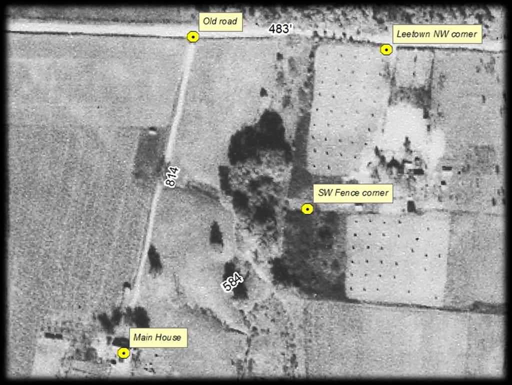
7 1940 Arial View
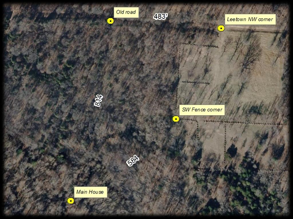
8 Current Arial View used to determine the points
9
10 COMMUNITY Pea Ridge National Military Park, our community and school will benefit from the efforts of our team in the following ways: Creating new information that will promote further research into Leetown area and the Mayfield House. Finding an exposed pipe in the ground, Virgil helped the park by marking the area and alerting the staff
11 CURRICULUM Course objectives Applied the techniques of GIS &GPS technologies towards our project. Identify the Mayfield House location on the Pea Ridge Battlefield by GPS coordinates and GIS mapping. Import, store, and manage geographical data from a variety of sources. Organize layers, including such tasks as layer activation, hierarchy, and manipulation of layer display properties to optimize visual effect. Create and analyze new data by creating spatial relationships between multiple datasets. Display results in a variety of formats, including maps, Power Point, onsite images. Utilize skills to create a GIS product for analysis of local problems, as a final group project (EMPACTS component).
 by esri technologies- description")

12 TECHNOLOGY Arc GIS esri (Global Information Systems) by esri technologies- description Microsoft Office, Word &PowerPoint- to create a presentation of the information GPS, etrex Venture HC
13 SKILLS DEVELOPED Teamwork skills- Interacting with each other in a productive manner. The teamwork skills that we develop will help in life and in our careers. Individual skills- GIS skills will help in a work environment. these skills give us knowledge and confidence.
14 SKILLS DEVELOPED Technology skills. Communication skills. Organizational skills

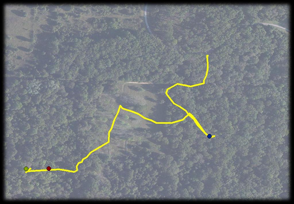
15 METHODOLOGY Ted made all professional contacts Jennifer and Vanessa collected waypoints using a GPS device The group downloaded the GPS data and created maps to show our path traveled


16 PROJECT OUTCOME What we found: Yucca plants framed the Stone foundation. An old Cellar Ground pipe Electric jack


17 TREASURES Rusted metal Glass bottles Tools
18 PROJECT RESULTS The Mayfield house was located The tracking on the GPS was loaded and identified successfully Red flags were placed along the route
19 ACKNOWLEDGMENTS Textbook- Mastering Arc GIS by Maribeth Price Paul Lowrey-map overlay Virgil Beck- Historian Kevin Eads-Pea Ridge National Military Park Dianne Philips- Website installation
20 APPENDICES Textbook- Mastering Arc GIS by Maribeth Price Vigil Beck, Historian- A Brief History of Leetown Hamlet Paul Lowrey- Map Overlay process using arial map from 18 and google earth map
21
22
23

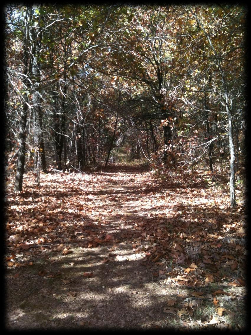
24 The Red trail leads to the Mayfield House, the Yellow trail was our failed first attempt
25

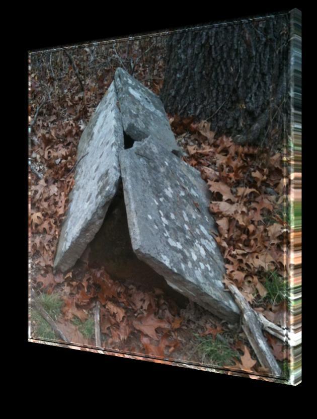
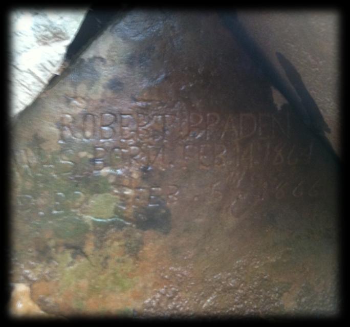
26 Leetown Cemetery
Bentonville Community Garden Introduction to Soils, EMPACTS Dr. Ted Seibert, Instructor
 Bentonville Community Garden Introduction to Soils, EMPACTS Dr. Ted Seibert, Instructor A living lab for all Vanessa Fisher, Cynthia Romero, John Schmohl, Nathan Buchanan and Adrienne Vanmatr Introduction
EMPACTS: Expand the Tall Grass Prairie. Survey of the Plant Kingdom Fall Semester
 EMPACTS: Expand the Tall Grass Prairie Survey of the Plant Kingdom Fall Semester Team Members Mike Willard- Labor, Team Leader, Researcher, Writer Tommy Parmain- Labor, Researcher, Writer, Computer Expert
Eastern Band of Cherokee Indians Integrated Geographical Information System (IGIS)
") Eastern Band of Cherokee Indians Integrated Geographical Information System (IGIS) 1 Background The Eastern Band of Cherokee Indians (EBCI) is the only federally recognized Tribe in North Carolina. Historically
Eastern Band of Cherokee Indians Integrated Geographical Information System (IGIS) 1 Background The Eastern Band of Cherokee Indians (EBCI) is the only federally recognized Tribe in North Carolina. Historically
Guadalupe Espinoza Spencer Sibert George Clark Nathan Sorey. Rain Gardens Impacts on Our Water s Lifecycle
 Guadalupe Espinoza Spencer Sibert George Clark Nathan Sorey Rain Gardens Impacts on Our Water s Lifecycle 1 Community Produced Engaging Media to Motivate: Appreciation for our natural resources Conservation
Only One in Ten (12%) can Identify Vimy Memorial from a Photo. Public Release Date: April 7, 2016
 can Identify Vimy Memorial from a Photo. Public Release Date: April 7, 2016") Eight in Ten (83%) Canadians say 100 th Anniversary of Battle of Vimy Ridge should be Key Celebration during Canada s 150 th Birthday in 2017 (Up 9 Points since Last Year) Only One in Ten (12%) can Identify
Eight in Ten (83%) Canadians say 100 th Anniversary of Battle of Vimy Ridge should be Key Celebration during Canada s 150 th Birthday in 2017 (Up 9 Points since Last Year) Only One in Ten (12%) can Identify
The Language of Geography. Health and Human Services
 The Language of Geography Health and Human Services Cover Points of Distribution: this Esri map shows population density in relation to vaccine distribution centers, helping health officials perform a
OVERMOUNTAIN VICTORY TRAIL BURKE CALDELL CORRIDOR FEASIBLITY STUDY REQUEST FOR QUALIFICATIONS CALDWELL COUNTY PATHWAYS
 OVERMOUNTAIN VICTORY TRAIL BURKE CALDELL CORRIDOR FEASIBLITY STUDY REQUEST FOR QUALIFICATIONS CALDWELL COUNTY PATHWAYS Caldwell County Pathways along with our co-partners City of Lenoir, Town of Gamewell,
Fence Builders links quality, reliability after 60 years in business
 Fence Builders links quality, reliability after 60 years in business By Fran Daniel Winston-Salem Journal Posted: Saturday, December 26, 2015 8:45 pm Fence A recently installed gate by Fence Builders Incorporated
IS THERE MONEY AVAILABLE FOR WORK IN HISTORIC CEMETERIES? The AHC is not aware of any funding available for cemetery preservation or maintenance.
 ALABAMA HISTORICAL COMMISSION The State Historic Preservation Office Voice: (334)242-3184 Fax: (334)262-1083 www.preserveala.org ALABAMA HISTORIC CEMETERY REGISTER WHAT IS THE ALABAMA HISTORIC CEMETERY
MapObjects. Embeddable Mapping and GIS Components for Application Developers
 MapObjects Embeddable Mapping and GIS Components for Application Developers MapObjects Embeddable Mapping and GIS Components for Application Developers With MapObjects software, developers can create applications
What are you reading for?
 Researching history What are you reading for? - Information (Rome was one of the most powerful empires of the ancient world) - Facts and opinions (Julius Caesar was assassinated by conspiring senators
GIS Training of Undergraduates: Campus Stormwater Mapping. Joanne Logan, University of Tennessee. Gordie Bennett, University of Tennessee
 GIS Training of Undergraduates: Campus Stormwater Mapping Joanne Logan, University of Tennessee Gordie Bennett, University of Tennessee Seth Benge, University of Tennessee Tim Prather, University of Tennessee
Grade 10 History of Canada - Unit 1 Lesson 5 WW1 Vimy Ridge. Textbook Making History Large paper for maps Birth of a Nation assignment.
 WW1 Vimy Ridge Objective: Time: Requirements: Activity Number Examine WW1 warfare In groups, explore Canadian actions at Vimy Ridge Examine impact of the event on the Canadian identity One period Overheads
Redesigning Vogel Flat Angeles National Forest, California
 Redesigning Vogel Flat Angeles National Forest, California WRPI Watershed Management Internship 2017 Cristina Plemel, Master s of Landscape Architecture California State Polytechnic University, Pomona
Preface. Erie. Scranton. Allentown. Pittsburgh. Harrisburg. Philadelphia
 The Southern Alleghenies Region The Southern Alleghenies Region spans the Laurel Highlands and Allegheny Front in the west across the Appalachians to the east. It is comprised of Blair, Bedford, Cambria,
2. AGENCY COORDINATION AND PUBLIC INVOLVMENT
 2. AGENCY COORDINATION AND PUBLIC INVOLVMENT This chapter discusses the process carried out for conducting agency coordination and public involvement activities. TECHNICAL ADVISORY COMMITTEE A Technical
OPERATING ROOM EQUIPMENT: GLOBAL MARKETS
 OPERATING ROOM EQUIPMENT: GLOBAL MARKETS IAS095A June 2014 Bhavna Joshi Project Analyst ISBN: 1-56965-864-1 BCC Research 49 Walnut Park, Building 2 Wellesley, MA 02481 USA 866-285-7215 (toll-free within
Town of Avon Village Center. A New Village Center for Avon October, 2015
 Town of Avon Village Center A New Village Center for Avon October, 2015 A busy Avon Center approx. 1940 The Avon Town Center Study: In 2004 the Planning and Zoning Commission (PZC) undertook the Avon
Redevelopment of a factory site. Case study: Redevelopment of a processing factory site, South Brisbane
 Redevelopment of a factory site Case study: Redevelopment of a processing factory site, South Brisbane Task You are a consultant town planner working in a private firm and your supervisor has asked you
Fairfax County Community Services Board Emergency Response System: Notifier
 Lathan S. Dennis, MSc., GIS Analyst Fairfax County, Human Services 12011 Government Center Parkway, Suite 946, Fairfax, VA 22035 Voice (703) 324-5648 Fax (703) 324-7572 Email ldenni@fairfaxcounty.gov Jim
Open Office Hours: Monday: 11:30-12:30 Tuesday, Wednesday: or by appointment
 College of Charleston Program in Historic Preservation and Community Planning - Department of Art History - HPCP 375 001 LANDSCAPE PRESERVATION AND DESIGN James L. Ward, SC RLA, Assistant Professor wardj@cofc.edu
Regional Training Workshop on Human Settlement indicators
 Regional Training Workshop on Human Settlement indicators Donatien Beguy, PhD Research and Capacity Development Branch UN-HABITAT Overview of 2030 Agenda for Sustainable Development and New Urban Agenda
Submitted: July 23, 2009
 Stage I and II Archaeological Assessment Jock River Estates Phase 2 PML Project No. 0801-01 Client: 773804 Ontario Inc. Lot 21, Concession 2 Geographic Township of Goulbourn City of Ottawa Submitted: July
MANAGING CHANGE IN THE HISTORIC ENVIRONMENT. Historic Battlefields August 2016
 MANAGING CHANGE IN THE HISTORIC ENVIRONMENT Historic Battlefields August 2016 Above: Most of Culloden battlefield lay under forestry until clearance by the National Trust for Scotland in the 1980s. While
The Urban Design Handbook Techniques And Working Methods Second Edition
 The Urban Design Handbook Techniques And Working Methods Second Edition We have made it easy for you to find a PDF Ebooks without any digging. And by having access to our ebooks online or by storing it
ArcGIS Data Reviewer. Planning and Deploying Data Quality Services. Edwin Waite & Shankar Chandrasekaran. Esri UC 2014 Technical Workshop
 ArcGIS Data Reviewer Planning and Deploying Data Quality Services Edwin Waite & Shankar Chandrasekaran Esri UC 2014 Technical Workshop A few examples of why data validation matters Esri UC 2014 Technical
CPA , Bristoe Station and Kettle Run Preservation Study Comprehensive Plan Amendment
 Bristoe Station and Kettle Run Battlefields Special Study Area Introduction and Background The Bristoe Station Battlefield consists of approximately 9,410 acres. This battle on October 14, 1863, was the
10/23/18. Science informed regional planning: opportunities for better outcomes. Seeking Better Outcomes for Our Regions
 SEGRA 2018: Beyond the Boom: opportunities for growth and vitality Acknowledge the Traditional Owners of the country where we are meeting today Science informed regional planning: opportunities for better
Customer Feedback Summary
 Customer Feedback Summary Of 81 customers surveyed, 71 responded Likely to Recommend 100% Professional & Organized 99% Trust 100% Construction Quality 97% Communication 100% Clean & Safe 100% Budget 96%
Subject: West District Long and Short Term Recommendations for a Fire Station.
 To: Summit Fire & Medical District Board From: Mark A. Gaillard, Fire Chief Date: September 12, 2017 Subject: West District Long and Short Term Recommendations for a Fire Station. Note: The following is
Archaeological Monitoring of Land at 29 Royal Pier Road, Gravesend, Kent
 Archaeological Monitoring of Land at 29 Royal Pier Road, Gravesend, Kent Site Code ROY/WB/15 Report for Dr Maxted Date of report 06/10/2015 SWAT ARCHAEOLOGY Swale and Thames Archaeological Survey Company
Black Rock Historic Resource Survey - Section PROJECT DESCRIPTION
 1.0 PROJECT DESCRIPTION Clinton Brown Company PN 08-019 1-1 November 2010 1.0 PROJECT DESCRIPTION Clinton Brown Company Architecture, pc has completed the Historic Resources Survey of the Black Rock Planning
Preservation Study for Bristoe Station and Kettle Run Battlefields Prince William County, Virginia
 Prince William County, Virginia Project Team: Commonwealth Heritage Group (Alexandria and Charlottesville Offices) Jo Balicki, Archeologist Jane Jacobs, Historical Landscape Architect Laura Knott, Historical
ACKNOWLEDGEMENTS. my loving wife: Karen Blaney. my thesis committee: Susan Piedmont-Palladino Paul Emmons Ron Kagawa
 an Institute for urban agriculture architecture, ecology and urban habitat ii Humankind has lived on earth for a geologically brief time. Our species has proven a remarkable ability to adapt to our environment
CIVIL WAR MEMORIAL ASSESSMENT FORM
 Print Form FORM CWM #61 PAGE 1 OF 4 NATIONAL ORGANIZATION SONS OF UNION VETERANS OF THE CIVIL WAR CIVIL WAR MEMORIAL ASSESSMENT FORM PLEASE: Type or print, using a ball-point pen, when filling out this
Global fire hotspots detected by NASA satellite to help United Nations
 Global fire hotspots detected by NASA satellite to help United Nations Published on 24 Sep 2010 is Image NASA's not found Moderate or type unknown Resolution Imaging Spectroradiometer (MODIS), an instrument
BeltLine Corridor Environmental Study
 BeltLine Corridor Environmental Study Joint TAC and SAC Meeting December 8, 2008 What We Will Discuss Today Outreach and Agency Coordination Scoping Results Existing Conditions Historical and Archeological
The Battle of Vimy Ridge Resources: Photographs
 Blasted View of Vimy Ridge This aerial photograph illustrates the major trench lines around an unknown sector on Vimy Ridge. The large craters, some ten to 15 metres deep, were made from mine explosions
Interpretive Planning Toolkit for Trails National Trails Conference May 2011
 Star-Spangled Banner National Historic Historic Trail Trail Star-Spangled Maryland Star-Spangled Banner Scenic Banner Byway Scenic Byway National Park Service Chesapeake Bay Office Chesapeake Bay Gateways
Art Nouveau Art Renouveau Erasmus+ Tour of Dortmund
 Co-funded by the Erasmus+ Programme of the European Union Art Nouveau Art Renouveau Erasmus+ Tour of Dortmund Town Trail through the Kreuzviertel The Kreuzviertel is an area of Dormund to the west of the
What Makes a Community?
 What Makes a Community? Town Green Walking Tour Teacher Guide This packet contains materials that educators can utilize in class before and after your visit to the Fairfield Museum and History Center.
GeoPlanner SM for ArcGIS : An Introduction
 GeoPlanner SM for ArcGIS : An Introduction Greg Pleiss Robert Stauder Esri UC 2014 Technical Workshop Agenda Application Overview Specific Capabilities - Configuration - Avaliable Data - Spatial Analysis
Technical Report: Ceremonial Stone Landscape Survey Avoidance Plan Memorandum
 Technical Report: Ceremonial Stone Landscape Survey Avoidance Plan Memorandum Ceremonial Landscape Survey, Wayland Historical Commission, Wayland MA A research product of Ceremonial Landscapes Research,
APPENDIX F CULTURAL HERITAGE RESOURCE ASSESSMENT
 APPENDIX F CULTURAL HERITAGE RESOURCE ASSESSMENT TO Katherine Jim, MRC DATE February 28, 2013 (Revised March 6 2013, May 27 2013, June 24 2013) FROM Lindsay Popert, ASI ASI FILE 12EA-084 RE Dundas Street
AcadianAmbulance.com
 Acadian.com Acadian is a diverse company with six divisions specializing in medical transportation and pre-hospital care; industrial health, safety and environmental services, training and consulting;
Outdoor Recreation and Conservation Careers Toolkit WEBINAR: OUTDOOR RECREATION AND CONSERVATION CAREERS TOOLKIT 1
 Outdoor Recreation and Conservation Careers Toolkit WEBINAR: OUTDOOR RECREATION AND CONSERVATION CAREERS TOOLKIT 1 The Outdoor Recreation Economy accounts for $646 billion in consumer spending annually
Technical Memorandum
 JB Industries Geostatistical Analysis of Spatial Data John Bull 2014 Introduction Finlay s Fabulous Ficiticious Fern, or Osmunda Finlayensis, is a plant species whose numbers took a sharp decline when
NATIONAL ORGANIZATION SONS OF UNION VETERANS OF THE CIVIL WAR CIVIL WAR MEMORIAL ASSESSMENT FORM
 FORM CWM #61 Page 1 of 4 NATIONAL ORGANIZATION SONS OF UNION VETERANS OF THE CIVIL WAR CIVIL WAR MEMORIAL ASSESSMENT FORM PLEASE: 1. Type or print, using a ball-point pen, when filling out this form. Legibility
analysis of the visible landscape ANTIETAM NATIONAL BATTLEFIELD / MARYLAND
 analysis of the visible landscape ANTIETAM NATIONAL BATTLEFIELD / MARYLAND ANTIETAM NATIONAL BATTLEFIELD ANALYSIS OF THE VISIBLE LANDSCAPE April 1988 CONTENTS BACKGROUND INTRODUCTION 1 Battle of Antietam
Three Pathways for Urban Change - Utilising planners and architects to realise the New Urban Agenda
 Three Pathways for Urban Change - Utilising planners and architects to realise the New Urban Agenda Alice Preston-Jones University of Sheffield Executive Summary Cities around the world are facing pressing
HISTORIC BRIDGES IN CRAWFORD COUNTY. Bridges Listed on the National Register of Historic Places in Crawford County
 Arkansas State Highway and Transportation Department HISTORIC BRIDGES IN CRAWFORD COUNTY Bridges Listed on the National Register of Historic Places in Crawford County 2004 Arkansas State Highway and Transportation
Funded by the Government of Canada Financé par le gouvernement du Canada
 Funded by the Government of Canada Financé par le gouvernement du Canada A trilogy of documentaries, activities and educational initiatives on how aviation changed the course of the First World War and
Table of Contents PART I: The History and Current Status of the Industrial HMI PART II: Fundamentals of HMI Design and Best Practices
 Table of Contents PART I: The History and Current Status of the Industrial HMI We begin with the origin and evolution of the industrial HMI. The positive and negative issues posed by the introduction of
Passport Learning Outcomes and Proficiency Criteria in Human Cultures FINAL
 1. Core Knowledge Define and apply knowledge of changing human cultures (including core vocabulary, terminology, information, concepts, theories and debates) The student will explain concepts, theories,
PROJECT INFORMATION. The type of development
 A LETTER OF RECOMMENDATION (WITH CONDITIONS) FOR THE EXEMPTION OF A FULL PHASE 1 ARCHAEOLOGICAL HERITAGE IMPACT ASSESSMENT FOR THE PROPOSED, CONSTRUCTION OF A FILLING STATION AND ASSOCIATED INFRASTRUCTURE
The Rocky Mountain Arsenal and the Northeast Greenway Corridor Project:
 The Rocky Mountain Arsenal and the Northeast Greenway Corridor Project: Contamination to Collaboration Presented by Howard Kenison Overview of Presentation Rocky Mountain Arsenal Contamination Litigation,
PG: 82B , Nottingham School House, Nottingham Road
 Nottingham (82B-035) Located in southeastern Prince George s County, the community of Nottingham was established when the General Assembly of the Province of Maryland passed the Act for the Advancement
Digitization For Long-Distance Oil Pipeline Leakage Detection. Liang Wei China University of Petroleum, Beijing
 Digitization For Long-Distance Oil Pipeline Leakage Detection Liang Wei lweimm@yahoo.com.cn China University of Petroleum, Beijing 1 Research Significance 2 Key Technologies CONTENTS 3 Digitization Pipeline
Activity 3 Little Sparta
 Activity 3 Little Sparta If you have worked though the activities in order, you will have now considered how the word literature might reach into other art forms such as music, and how it creates distinctions
CIVIL WAR MEMORIAL ASSESSMENT FORM
 Print Form FORM CWM #61 PAGE 1 OF 4 NATIONAL ORGANIZATION SONS OF UNION VETERANS OF THE CIVIL WAR CIVIL WAR MEMORIAL ASSESSMENT FORM PLEASE: Type or print, using a ball-point pen, when filling out this
Prince William County Department of Fire & Rescue 1 County Complex Court Prince William, Virginia (Main) (Fax)
 (Fax)") Prince William County Department of Fire & Rescue 1 County Complex Court Prince William, Virginia 22192-9201 703-792-6800 (Main) 703-792-7691 (Fax) www.pwcgov.org/fire Revised March 2014 About Us Prince
Prince William County Department of Fire & Rescue 1 County Complex Court Prince William, Virginia 22192-9201 703-792-6800 (Main) 703-792-7691 (Fax) www.pwcgov.org/fire Revised March 2014 About Us Prince
Risk Analysis Tools to Support Resilient Design
 Risk Analysis Tools to Support Resilient Design 1755 Cape Ann 6.3: BC WO Paul A. Morey FEMA Region I Woods Hole, MA/NOAA Hurricane & Earthquake Program Manager Maps Commonly used by FEMA and other Federal,
City of Meriden Harbor Brook Flood Control Project Overview
 City of Meriden Harbor Brook Flood Control Project Overview Updated August 2013 OVERVIEW The center of Meriden, including the HUB site is the low point of the town which is ringed by basalt ridges. Running
Form DOT F (8-72) Technical Report Documentation Page 2. Government Accession No. 3. Recipient's Catalog No.
 Technical Report Documentation Page 2. Government Accession No. 3. Recipient's Catalog No.") 1. Report No. FHWA/TX-09/5-4577-03-1 4. Title and Subtitle IMPLEMENTING GPS INTO PAVE-IR Technical Report Documentation Page 2. Government Accession No. 3. Recipient's Catalog No. 5. Report Date October
1. Report No. FHWA/TX-09/5-4577-03-1 4. Title and Subtitle IMPLEMENTING GPS INTO PAVE-IR Technical Report Documentation Page 2. Government Accession No. 3. Recipient's Catalog No. 5. Report Date October
School Programmes. Delivering the Curriculum for Excellence through creative, outdoor learning.
 Delivering the Curriculum for Excellence through creative, outdoor learning. Water of Leith Visitor Centre 24 Lanark Road Edinburgh EH14 1TQ Tel: 0131 455 7367 Email:admin@waterofleith.org.uk www.waterofleith.org.uk
SPC GUIDE NAAB 2014 STUDENT PERFORMANCE CRITERIA School of Architecture - University of Arizona NAAB SCHOOL OF ARCHITECTURE
 SPC GUIDE NAAB 2014 STUDENT PERFORMANCE CRITERIA NAAB SCHOOL OF ARCHITECTURE s partial s introductory s SPC as defined by the National Architectural Accrediting Board, Inc. A course assigned a Claim is
Burlington County, NJ GIS Day Map Gallery and Contest Winners
 Burlington County, NJ GIS Day Map Gallery and Contest Winners - 2018 The Burlington County GIS Day Map Gallery and contest was displayed at Rowan College at Burlington County during the annual GIS Day
UCSB Campus Flora Project Final Report July 1st, February 28th, Jennifer Thorsch, Ph.D. Katherine Esau Director
 UCSB Campus Flora Project Final Report July 1st, 2008- February 28th, 2010 Jennifer Thorsch, Ph.D. Katherine Esau Director Rachel Alford Project Manager Cheadle Center for Biodiversity and Ecological Restoration
Appendix 6 Historic Preservation For more information, call the Historic Preservation Division at Wheaton CBD and Vicinity Sector Plan
 Appendix 6 Historic Preservation For more information, call the Historic Preservation Division at 301-563-3400 montgomery county planning board maryland-national capital park and planning commission Wheaton
RECOMMENDED COURSE SEQUENCE
 RECOMMENDED COURSE SEQUENCE 3-Year Program First Professional Degree First Year LA 501 Studio I 3 LA 504 Studio III 3 LA 503 Studio II 3 LA 506 Studio IV 3 LA 592A & 696L Plants in the Landscape & Lab
APPENDIX 9 HERITAGE CHARACTER
 APPENDIX 9 HERITAGE CHARACTER Defining attributes and features Perth Official Plan Appendix 9 HERITAGE CHARACTER defining attributes and features This appendix includes a table describing heritage attributes
Master Planning: Cuba, New York Phase II. Dr. John Anderson President Alfred State College. Alfred New York
 Master Planning: Cuba, New York Phase II Dr. John Anderson President Alfred State College Alfred, New York 14802 607-587-4211 February 1, 2011 June 30, 2012 March 5, 2012 Craig R Clark, PE Dean, School
City of Lake Mary, Florida. Evolution of a Historic Downtown with Transit Oriented Development Strategies
 City of Lake Mary, Florida Evolution of a Historic Downtown with Transit Oriented Development Strategies What is Transit Oriented Development? Walkable villages located at and around transit stations in
Health Care. NewVoice. San Francisco Paris Geneva Zurich Linz Mainz Shanghai Brisbane Hong Kong São Paulo Dubai
 Health Care Emergency & Medical Services Nurse Call Heart Alarm Emergency Hotline Skill Based Mobilization Emergency Conference Bed Transportation MobiCall Health Care Security & Infrastructure MobiCall
Landscape Architecture - LAND
 Landscape Architecture - LAND 1 Landscape Architecture - LAND Courses LAND 5030 LANDSCAPE DESIGN METHODS (3) LEC. 9. Introduces students to skills, techniques, and ways of thinking fundamental to landscape
OPEN SPACE CHAPTER 7: OVERVIEW. Preserve open space to protect natural resources, enhance character and provide passive recreation opportunities
 CHAPTER 7: OPEN SPACE OVERVIEW Ridgefield has made tremendous progress permanently preserving areas of town as open space. Open space preservation can serve many important purposes, including: protect
THE TRIBOELECTRIC SCALE
 W 460 THE TRIBOELECTRIC SCALE Understanding Energy Transfer and the Triboelectric Scale Lorie Burtts, UT Extension Agent, Moore County Jennifer Richards, Assistant Professor, 4-H Youth Development MANAGEMENT
The Esri Public Works Platform. More Than Mapping
 The Esri Public Works Platform More Than Mapping Intelligent Public Works Sustaining a safe, vibrant community requires a smart public works system. Esri created a platform that connects public works departments
Iwo Jima Uncommon Valor was a Common Virtue. Amanda Lee. Minnesota School of Business
 Iwo Jima 1 Running head: IWO JIMA Iwo Jima Uncommon Valor was a Common Virtue Amanda Lee Minnesota School of Business Humanities 100 Mr. Don Kirk Macon August 3, 2008 Iwo Jima 2 Iwo Jima Uncommon Valor
Smart Growth for Dallas
 Smart Growth for Dallas Data-driven decisions for the future of Dallas parks, open spaces, and green infrastructure Dallas Park and Recreation Board March 10, 2016 Agenda I. Welcome and Introductions II.
The Conservation Fund The Center for Conservation and Development
 The Conservation Fund The Center for Conservation and Development Partners in Land and Water Conservation Smart Growth and Sustainable Ranges August 23, 2004 Savannah, GA The Conservation Fund--8/23/04
Environmental Impact Assessment (EIA) Training Session
 Training Session") Die Deutsche Gesellschaft für Internationale Zusammenarbeit (GIZ) GmbH Environmental Impact Assessment (EIA) Training Session By: Nedal Al Ouran (Ph.D.) AMMAN- November 6, 2013 Outline 1. Introduction
Die Deutsche Gesellschaft für Internationale Zusammenarbeit (GIZ) GmbH Environmental Impact Assessment (EIA) Training Session By: Nedal Al Ouran (Ph.D.) AMMAN- November 6, 2013 Outline 1. Introduction
Preparing to Review City-owned Property
 Preparing to Review City-owned Property June 28, 2017 WORKING DRAFT Prepared for: Mayor DeBoer and the Holland City Council Prepared by: Denny Ellens William J. Johnson Soren Wolff Phil Meyer REPORT CONTENTS
Phase One Archaeological Investigation Results, James Madison Park Master Development Plan Project, City of Madison, Dane County, Wisconsin
 Phase One Archaeological Investigation Results, James Madison Park Master Development Plan Project, City of Madison, Dane County, Wisconsin Prepared for the City of Madison Parks Department 28 January
Enhanced FOUNDATION Fieldbus Physical Layer Diagnostics with the DeltaV System
 November 2006 Page 1 Enhanced FOUNDATION Fieldbus Physical Layer Diagnostics This document provides possible solutions that allow enhanced Ff (FOUNDATION fieldbus) physical layer diagnostics using the
The Georgia Southern Heritage
 The Georgia Southern Heritage Volume 3, Issue 6 June 2015 I N S I D E T H I S I S S U E 1 From The Captain From the Captain Men, Another Mechanized Cavalry Annual has come and gone. The Brothers in Oklahoma
COLVER ROAD INDUSTRIAL CONCEPT PLAN
 COLVER ROAD INDUSTRIAL CONCEPT PLAN A CONCEPTUAL LAND USE AND TRANSPORTATION PLAN FOR TA-4 AN URBAN RESERVE AREA OF THE CITY TALENT City of Talent Adopted by City Council Resolution No., June, 2015 PART
13 Extending the Esri Enterprise Licence Agreement
 Clause 13 in Report No. 10 of Committee of the Whole was adopted, without amendment, by the Council of The Regional Municipality of York at its meeting held on May 21, 2015. 13 Extending the Esri Enterprise
LASER SAFETY TRAINING CATALOG LASER LASER INSTITUTE OF AMERICA S MAKE LASER SAFETY YOUR PRIORITY.
 MAKE LASER SAFETY YOUR PRIORITY LASER INSTITUTE OF AMERICA S LASER SAFETY TRAINING CATALOG www.lia.org 13501 Ingenuity Dr., Suite 128 32826 Phone: +1.407.380.1553 Fax: +1.407.380.5588 INDUSTRIAL/RESEARCH
CITY OF SNELLVILLE GREENWAY MASTER PLAN
 CITY OF SNELLVILLE GREENWAY MASTER PLAN NOVEMBER 2017 This page intentionally left blank. INTRODUCTION Greenways are a hot topic in planning and urbanism circles. Many communities across Georgia and the
TOWN OF AURORA HERITAGE IMPACT ASSESSMENTS AND CONSERVATION PLANS GUIDE
 PLANNING AND DEVELOPMENT SERVICES Development Planning Division Heritage Planning Section Phone: 905-727-3123 ext. 4226 Fax: 905-726-4736 Email: planning@aurora.ca Town of Aurora 100 John West Way, Box
Battery Performance Alert
 Battery Performance Alert A TOOL FOR IMPROVED PATIENT MANAGEMENT FOR S UNDER BATTERY ADVISORY VERSION 2.0 Abstract BACKGROUND: In October 2016, St. Jude Medical (now Abbott) issued an advisory on a family
jardins de la paix peace gardens
 jardins de la paix peace gardens CALL FOR PROPOSALS LE QUESNOY (France) - NEW-ZEALAND Mission du centenaire de la Première Guerre mondiale date de publication, février 2018 - Version 2 OVERALL PRESENTATION
OVERVIEW davidnicebuilders.com
 OVERVIEW The foundation of David A. Nice Builders is people. Starting with our strong family roots, the company has maintained a hands-on, personal connection in every aspect of the business. We take tremendous
Juan C. Feliciano Marvel Marchand Architects. Gowanus Green Master Plan: Reclaiming a Brownfield Site for NYC May 10 th, 2017
 Juan C. Feliciano Marvel Marchand Architects Gowanus Green Master Plan: Reclaiming a Brownfield Site for NYC May 10 th, 2017 Aerial view. Source: Google Maps Historical Facts The Gowanus Canal is a 100-foot-wide,
Introduction. Chapter 1. Purpose of the Comprehensive Plan Plan Organization Planning Process & Community Input 1-1
 Chapter 1 Introduction Lakewood 2025: Moving Forward Together Purpose of the Comprehensive Plan Plan Organization Planning Process & Community Input 1-1 Purpose of the Comprehensive Plan The Comprehensive
Victoria s Avenues of Honour Reconnecting with our past
 Victoria s Avenues of Honour Reconnecting with our past 2013-2018 Primary School Teachers Manual. Downloadable PDF documents full of a range of activities for different ages and levels. 1 Activities for
Greener Nebraska Towns Small-Scale Project Application
 Greener Nebraska Towns Small-Scale Project Application October 2016 A program of the Nebraska Statewide Arboretum, funded by the Nebraska Environmental Trust. Biodiversity is the greatest treasure we have.
Big Data Use Cases. Thomas Paschke Product Specialist Real-Time & Big Data. EDC Forum - Big Data Analytics in Geographic Information Systems
 Big Data Use Cases Thomas Paschke Product Specialist Real-Time & Big Data EDC Forum - Big Data Analytics in Geographic Information Systems ArcGIS Enterprise with real-time & big data capabilities ArcGIS
Huron Pines AmeriCorps
 POSITION TITLE: PRIMARY SERVICE LOCATION: RESPONSIBLE TO: Grand Traverse Regional Land Conservancy Huron Pines AmeriCorps Position Description Stewardship Technician Traverse City, Michigan Jon Throop,