Big Data Use Cases. Thomas Paschke Product Specialist Real-Time & Big Data. EDC Forum - Big Data Analytics in Geographic Information Systems
|
|
|
- Vernon Montgomery
- 6 years ago
- Views:
Transcription

1 Big Data Use Cases Thomas Paschke Product Specialist Real-Time & Big Data EDC Forum - Big Data Analytics in Geographic Information Systems
2 ArcGIS Enterprise with real-time & big data capabilities ArcGIS Enterprise IoT Big Data GeoEvent Server spatiotemporal big data store GeoAnalytics Server 2 Esri Deutschland GmbH
3 Commercial - Financial Services - Insurance - Logistics / Trucking - Manufacturing - Media & Entertainment - Real Estate - Retail Defense & Intelligence - Intelligence - Military Operations Public Safety - Emergency / Disaster Mgmt - Fire, Rescue, EMS - Homeland Security - National Security - Law Enforcement - Special Events Natural Resources - Agriculture - Forestry - Mining - Oil & Gas - Pipeline 1,144 Organizations 85 Countries Health & Human Services - Hospital & Health Systems - Pharmaceuticals - Public Health Transportation - Aviation - DOT - Railways - Maritime & Ports - Public Transit Government - National - State - Local Utilities - Electric & Gas - Telco / Cable - Public Works Water - Water resources - Water / wastewater / stormwater Professional Services - AEC - Environmental Mgmt - GIS & IT Nonprofits & Education - Conservation - Humanitarian - Sustainable Development - Higher Ed - Research/Science Institutions Real-Time GIS usage as of June 2017


4 Boston Marathons Public Safety


5 2014/2015 Boston Marathon Public Safety


6 Los Angeles Bureau of Sanitation Vehicle Tracking & Service Management

7 Los Angeles Bureau of Sanitation Vehicle Tracking & Service Management


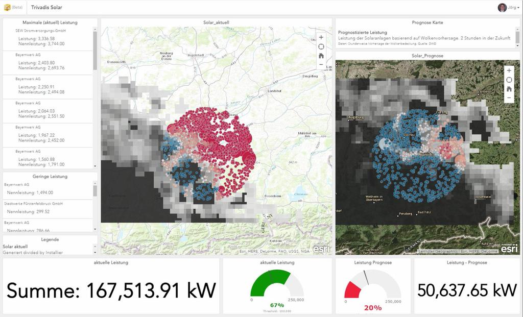
8 Alternative Energy Sensor Network Monitoring


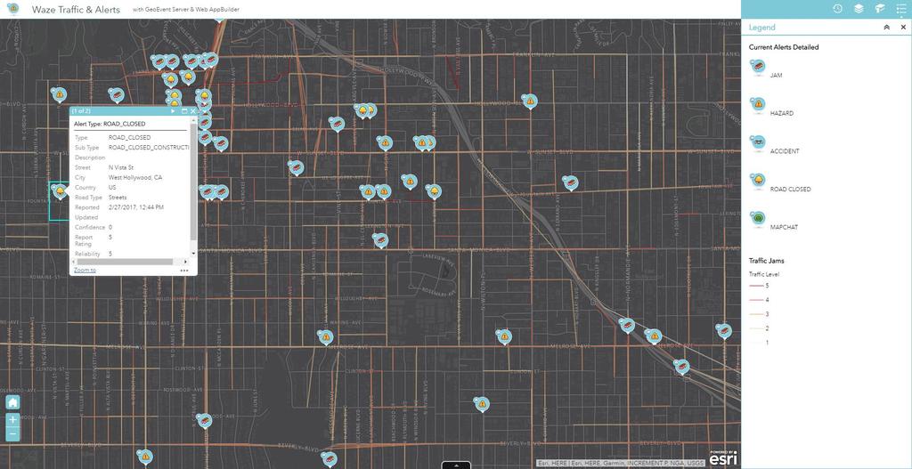
9 Waze Real-Time Waze Traffic & Alert Feed


10 Waze Connected Citizens Live & Historic Traffic Data
11 ArcGIS Enterprise with real-time & big data capabilities ArcGIS Enterprise IoT Big Data GeoEvent Server spatiotemporal big data store GeoAnalytics Server 11 Esri Deutschland GmbH
12 Use Case PV Output Prediction Echtzeit: Weather Information Real-Time: Installed PV Output Capacity planning & optimization Ingest Real-Time Data Join weather forcast to PV locations Busines Logic: Calculate forcasted output GeoEvent (Realtime) GeoAnalytics Dashboard Stockexchange Broker Process Big Data Store Datatransfer 12
13
14
15
16


17 Use Case Flood Warning + Ingest and analyze precipitation forcast via GeoEvent Server + Perform scheduled and reoccuring analysis to aggregate precipitation data into catchment areas for sewer system > Predict which roads will probably be flooded > Better coordinate help & counter measures 17 Esri Deutschland GmbH Source:

18 18 Esri Deutschland GmbH

19 19 Esri Deutschland GmbH

20 20 Esri Deutschland GmbH

21 21 Esri Deutschland GmbH

22 22 Esri Deutschland GmbH

23 23 Esri Deutschland GmbH

24 24 Esri Deutschland GmbH

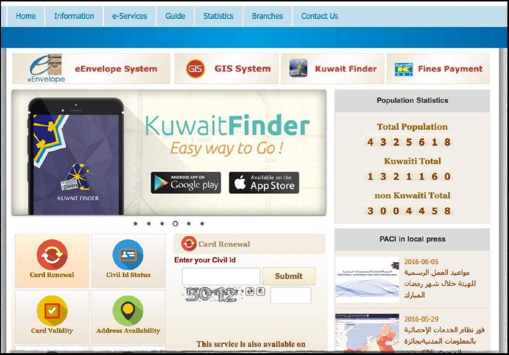
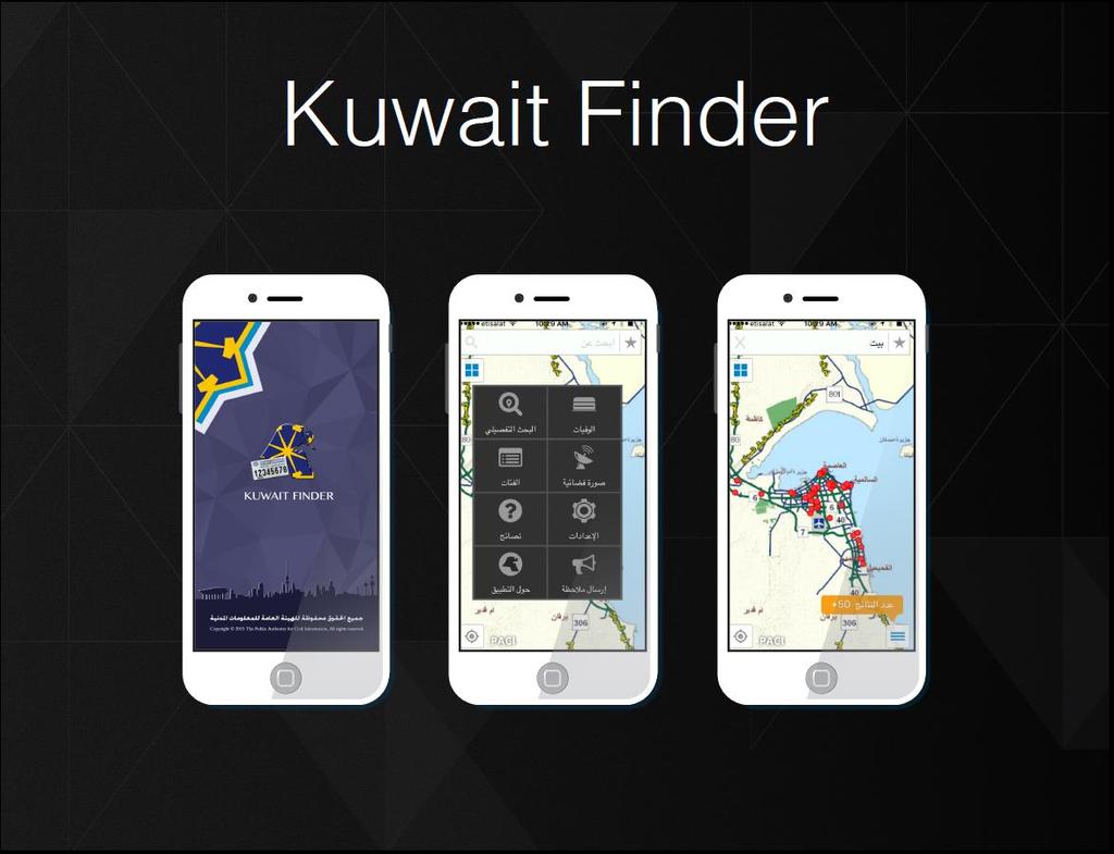
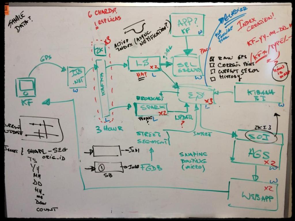
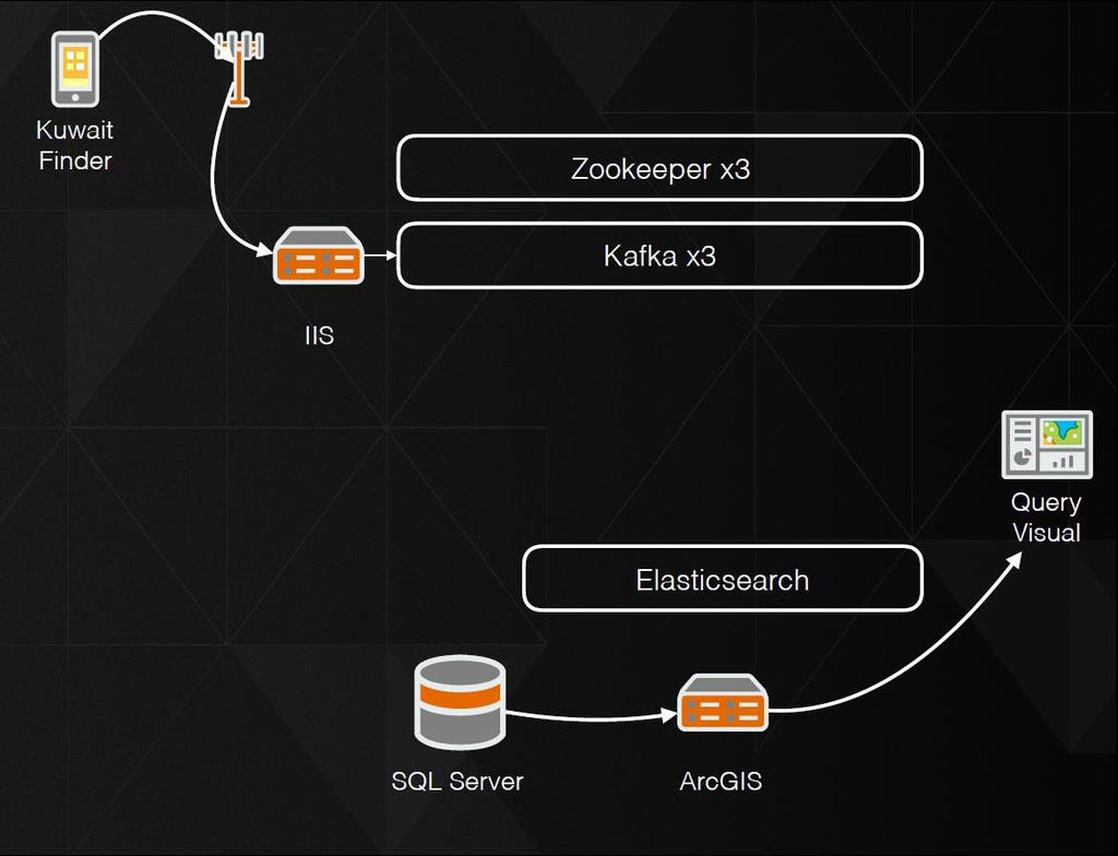
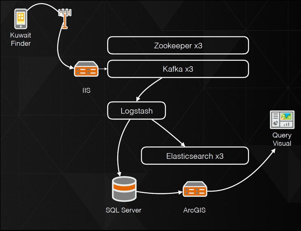
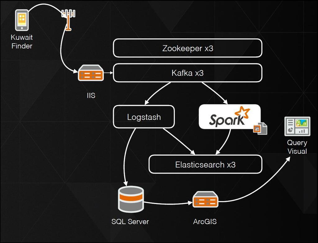
25 PACI Kuwait
26
27
28 Phone = Sensor
29
30
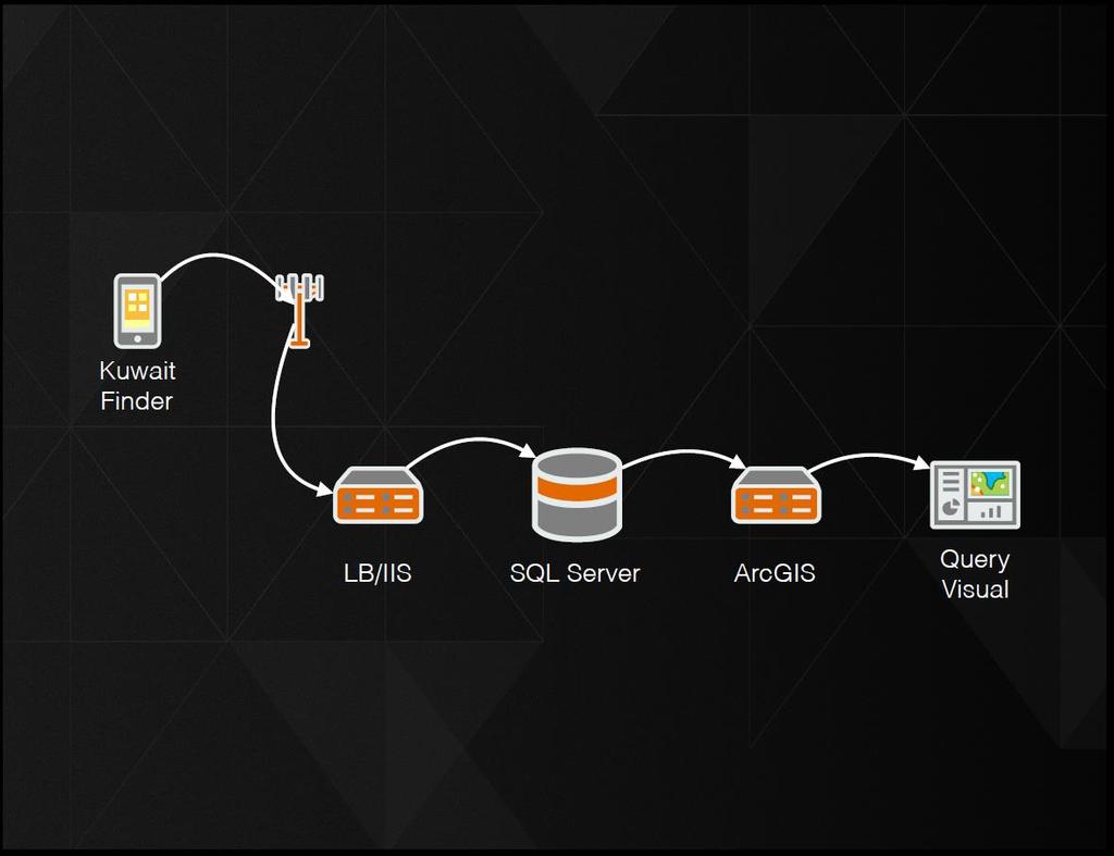
31 Requirements No Single Point of Failure Still have data in SQLServer for legacy apps Fast Write and Read to database Log everything Quick Analytics and On Demand Maps
32
33
34
35
36
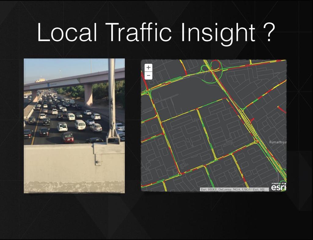
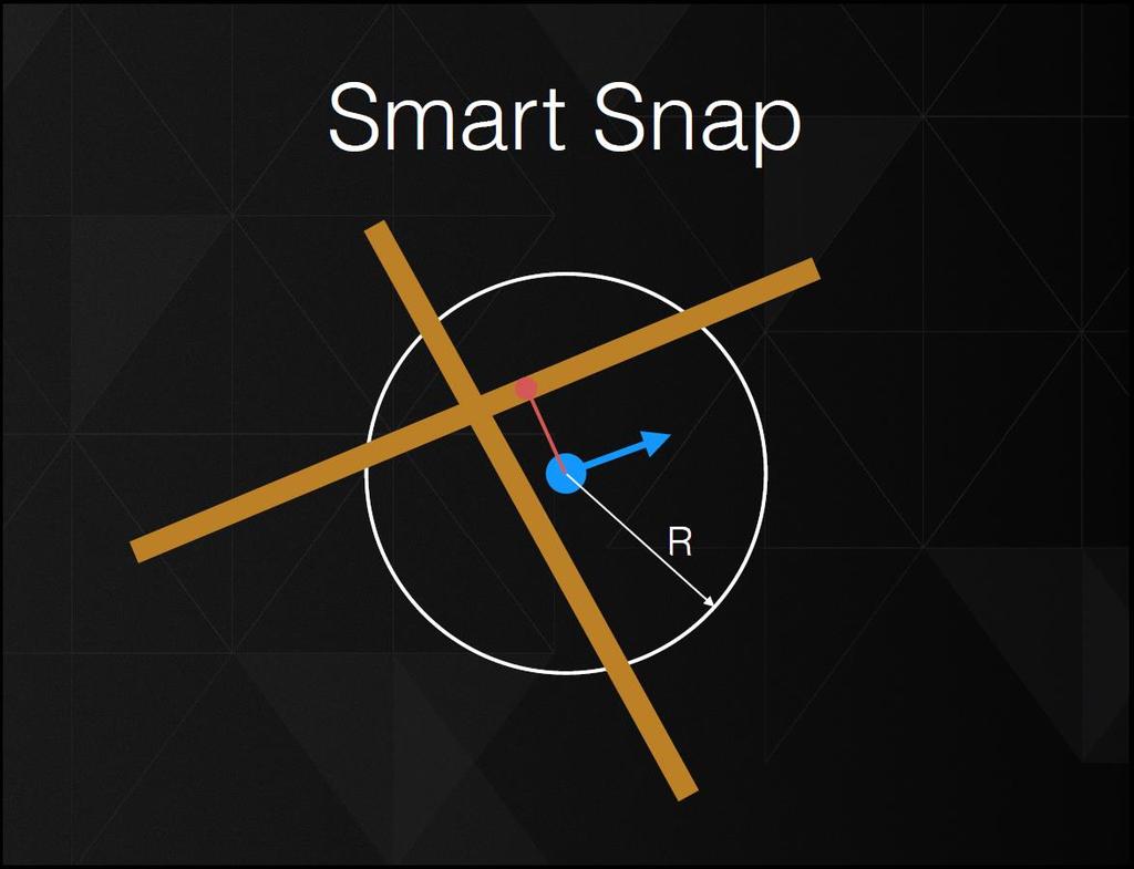
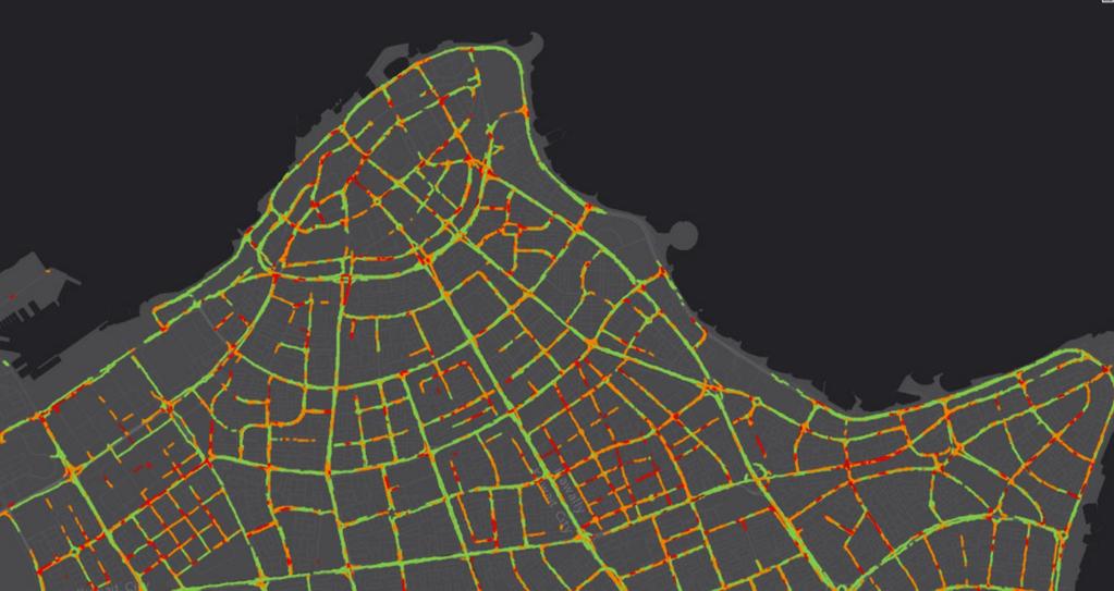
37 Fast Road Snapper Given GPS location, heading, speed, time Given street type, direction, length Find snapped location Update and accumulate number of snaps per segment
38
39

40 SOI ArcGIS Server Object Interceptor Intercepts MapService Request Invokes Spatial Query on Elasticsearch Creates Dynamic Map Image of Result

41


42 GeoEvent Server GeoAnalytics Server spatiotemporal big data store Map service BDS MapService with on-the-fly Aggregation
43 Web Device Desktop project Trinity ArcGIS Enterprise with real-time & big data Sensors sources hubs real-time batch spatiotemporal archive

44 ArcGIS Enterprise with real-time & big data Continuous Resilient Stream Processing project Trinity Reoccurring every x Minutes sources hubs real-time spatiotemporal archive batch
45


46 Predicting Crime Using Analytics and Big Data Map epidemiological issues, such as babies with low birth weights Aggregating personal health information to identify patterns Merged Esri s GIS software with police data and city maps to create new maps displaying the migration paths of neighborhood shootings [ ]. Social Media Content Fuels Big Data Analytics for Esri and IBM. Twitter content is now being mined and is used in analytics methodologies developed by Esri, IBM, and various stakeholders

47
48 Esri Deutschland, Esri Schweiz, Esri Rwanda, Esri Burundi Esri Deutschland GmbH Ringstraße Kranzberg Telefon info@esri.de Niederlassung Berlin Karl-Liebknecht-Str Berlin Telefon info@berlin.esri.de Niederlassung Köln Konrad-Adenauer-Ufer Köln Telefon info@koeln.esri.de Niederlassung Leipzig Fechnerstraße Leipzig Telefon info@leipzig.esri.de Esri Schweiz AG Zürich Josefstrasse Zürich Telefon info@esri.ch Esri Suisse SA Nyon Grand-Rue Nyon Telefon info@nyon.esri.ch Esri Rwanda Ltd. Kigali KG 5 Ave, Nr 18, Kacyiru P.O. Box 6867 Kigali, Rwanda Lat. 1 56'46.9" S; Long. 30 5'24.8" E Telefon info@esri.rw Niederlassung Bonn Rheinallee Bonn Telefon info@bonn.esri.de Niederlassung Hannover Schiffgraben Hannover Telefon info@hannover.esri.de Niederlassung Münster Martin-Luther-King-Weg Münster Telefon info@muenster.esri.de Esri Rwanda Ltd. Kigali KG 5 Ave, Nr 18, Kacyiru P.O. Box 6867 Kigali, Rwanda Lat. 1 56'46.9" S; Long. 30 5'24.8" E Telefon info@esri.rw 48 Esri Deutschland GmbH
The Esri Public Works Platform. More Than Mapping
 The Esri Public Works Platform More Than Mapping Intelligent Public Works Sustaining a safe, vibrant community requires a smart public works system. Esri created a platform that connects public works departments
GEO-SPATIAL TECHNOLOGY BOUSTEAD GEO-SPATIAL TECHNOLOGY
 lutions Water & Wastewater Engineering Energy-Related Engineering Geo-Spatial Technology Industrial Real Estate Solutions Discovering where advantage begins GEO-SPATIAL TECHNOLOGY BOUSTEAD GEO-SPATIAL
ArcGIS Data Reviewer. Planning and Deploying Data Quality Services. Edwin Waite & Shankar Chandrasekaran. Esri UC 2014 Technical Workshop
 ArcGIS Data Reviewer Planning and Deploying Data Quality Services Edwin Waite & Shankar Chandrasekaran Esri UC 2014 Technical Workshop A few examples of why data validation matters Esri UC 2014 Technical
Esri Roads and Highways: Integrating and Developing LRS Business Systems
 Esri Roads and Highways: Integrating and Developing LRS Business Systems Tom Hill Esri UC 2014 Technical Workshop Overview: Esri Roads and Highways Esri UC 2014 Technical Workshop Esri Roads and Highways:
Indoor Location, Tracking, and Routing
 2013 Esri International User Conference July 8 12, 2013 San Diego, California Technical Workshop Indoor Location, Tracking, and Routing Wolfgang Hall, Esri Tobias Donaubauer, Infsoft Robert Garrity, Esri
Welcome to Esri's Software Export Control Classification Number (ECCN) Matrix August 2017
 Matrix August 2017") Welcome to Esri's Software Export Control Classification Number (ECCN) Matrix August 2017 This portion of the Esri web site is to provide information regarding the export control classification of Esri
Welcome to Esri's Software Export Control Classification Number (ECCN) Matrix August 2017 This portion of the Esri web site is to provide information regarding the export control classification of Esri
Being Prepared and Providing Situational Awareness, through the use of Web GIS
 Being Prepared and Providing Situational Awareness, through the use of Web GIS Captain Michael Brady, Commanding Officer GIS Unit, Fire Department City of New York Who We Are 11,198 Firefighters and Fire
13 Extending the Esri Enterprise Licence Agreement
 Clause 13 in Report No. 10 of Committee of the Whole was adopted, without amendment, by the Council of The Regional Municipality of York at its meeting held on May 21, 2015. 13 Extending the Esri Enterprise
Esri Maps for MicroStrategy: Tips and tricks Chaka Clarke & Constantinos Papantoniou
 Esri Maps for MicroStrategy: Tips and tricks Chaka Clarke & Constantinos Papantoniou Esri UC 2016 Demo Theater Esri Maps for MicroStrategy: Tips and tricks Esri Maps for MicroStrategy brings location analytics
SMART CITY SAFE CITY. Anvesh Mangalam, IPS Additional Director General of Police, M P Police And Dr. Sandeep Goyal, Senior Principal Scientist, MPCST
 SMART CITY SAFE CITY By Anvesh Mangalam, IPS Additional Director General of Police, M P Police And Dr. Sandeep Goyal, Senior Principal Scientist, MPCST CHALLENGES 1. City and highway surveillance and safety
Session VI Smart safety systems
 Session VI Smart safety systems September 09th, 2016 Kolkata Denzil D Enterprise security Building Technologies Siemens Ltd Siemens AG 2011. All rights reserved. Safety every where Hospital Office Residential
Put Yourself on the Map: The Fusion of the PI System & Esri ArcGIS
 Put Yourself on the Map: The Fusion of the PI System & Esri ArcGIS Presented by Danny Spillmann, Director Global Energy, Esri Inc. Stewart Young, Global Alliance Manager, OSIsoft LLC. Anders Røpke, Lead
An affiliate company of AR Challenges, Ltd. ISRAEL
 1. Airport & Aviation security and operations efficiency. 2. First Responders Equipment, Systems & Training. 3. Port and Marina security management. (ISPS) 4. Public transportation security and management.
GeoPlanner SM for ArcGIS : An Introduction
 GeoPlanner SM for ArcGIS : An Introduction Greg Pleiss Robert Stauder Esri UC 2014 Technical Workshop Agenda Application Overview Specific Capabilities - Configuration - Avaliable Data - Spatial Analysis
User Advocacy Group. Rohit Gupta
 User Advocacy Group Rohit Gupta Agenda Introduction to User Advocacy Group (UAG) UAG Process User Communities Initiatives User Advocacy Group Mission To enhance the productivity of the user community by
Smart Growth for Dallas
 Smart Growth for Dallas Data-driven decisions for the future of Dallas parks, open spaces, and green infrastructure Dallas Park and Recreation Board March 10, 2016 Agenda I. Welcome and Introductions II.
Securing Your World. Who we are. What we do
 Securing Your World G4S Risk Management is a leading provider of risk mitigation, secure support services and integrated solutions to governments, international agencies and multinational corporations,
DSS. Dahua VMS Platform
 DSS Dahua VMS Platform CATALOG 1 2 3 4 5 Introduction Functions Add-ons Advantages Vertical DSS7016D/DSS4004 DSS DSS Mobile phone Embedded Linux client WEB, PC Client DSS7016D/DSS4004 Centre management
Evolving into the Networked Society
 Evolving into the Networked Society M2M evolution 2014 Las Vegas Magnus Lundgren Head of Connected Vehicle Cloud Ericsson A CONNECTED WORLD IS JUST THE BEGINNING When one person connects, their world changes.
The Language of Geography. Health and Human Services
 The Language of Geography Health and Human Services Cover Points of Distribution: this Esri map shows population density in relation to vaccine distribution centers, helping health officials perform a
Perfect Grounding system. SmartEco M2M. Maximum 67% high-efficiency power saving function. (Machine to Machine, Machine to Mobile)
") Perfect Grounding system SmartEco M2M Maximum 67% high-efficiency power saving function (Machine to Machine, Machine to Mobile) SmartEco M2M SmartEco M2M(Machine to Machine, Machine to Mobile) Mobile service
Perfect Grounding system SmartEco M2M Maximum 67% high-efficiency power saving function (Machine to Machine, Machine to Mobile) SmartEco M2M SmartEco M2M(Machine to Machine, Machine to Mobile) Mobile service
MapObjects. Embeddable Mapping and GIS Components for Application Developers
 MapObjects Embeddable Mapping and GIS Components for Application Developers MapObjects Embeddable Mapping and GIS Components for Application Developers With MapObjects software, developers can create applications
Live, Work, Locate and Site Selector
 Configuring Live, Work, Locate and Site Selector in Your Community John Hauck ArcGIS for State Government Solutions for Esri s government customers Series of useful maps and apps focused on government
Smart City Governance URBIS Solutions. David Ludlow, Assoc. Professor European Smart Cities University of the West of England, Bristol
 Smart City Governance URBIS Solutions David Ludlow, Assoc. Professor European Smart Cities University of the West of England, Bristol Integrated smart city model Smart Mobility Services focused on decreasing
1 ESRI User Conference Eastside Greenway
 1 ESRI User Conference Eastside Greenway Grand Rapids, Michigan ~200,000 residents 45 sq. miles Leader in smart public investment Green infrastructure program ArtPrize BeerCity USA 2 ESRI User Conference
Powered by HERE IS THE SOLUTION FOR YOUR NEEDS TRANSPORT SECURITY SOLUTIONS
 Powered by HERE IS THE SOLUTION FOR YOUR NEEDS TRANSPORT SECURITY SOLUTIONS Objective To secure perimeter from unauthorize intruders Monitor driver behaviour Track all vehicles through a centralised monitoring
Application Guide. IIoT enabled Intelligent Battery Management
 Application Guide IIoT enabled Intelligent Battery Management Small stationary batteries provide critical local backup power reserve in numerous applications. Lead acid batteries are well established technology
iwater project Holistic, Sustainable and Cost-Effective Stormwater Management
 iwater project Holistic, Sustainable and Cost-Effective Stormwater Management Nika Kotoviča Stockholm, 28 November 2017 Urban Climate Adaptation in the Baltic Sea Region Training Workshops Integrated Storm
Samsung SDS BMS Ver.2.0. Technical Specification
 Samsung SDS BMS Ver.2.0 Technical Specification Technical Specifications All rights and title, including all intellectual property rights to Samsung SDS BMS" is retained by Samsung SDS Co, Ltd. ("SDS"),
Gatesea Technology Co., Ltd
 Gatesea Technology Co., Ltd Address: Building 9, E-PARK, South Fuwan Road, Zhongshan 528400, Guangdong, China Website: www.sunwebcam.com Email: sales@sunwebcam.com/sales2@sunwebcam.com Sunwebcam- 4G Solar
ArcGIS Online at Philadelphia Water Department
 ArcGIS Online at Philadelphia Water Department ESRI Public Sector Conference December 2017 Jessica Gould, GISP Megan Clarkin, AICP, LEED Green Associate Tim Smith We provide the City with integrated water,
WHITE PAPER FEBRUARY Oracle Retail: Optimize Performance and Reduce Business Risk
 WHITE PAPER FEBRUARY 2018 Oracle Retail: Optimize Performance and Reduce Business Risk 2 WHITE PAPER ORACLE RETAIL: OPTIMIZE PERFORMANCE AND REDUCE BUSINESS RISK ca.com Table of Contents Section 1 3 Introduction
Integrated Security and Building Automation Technology Solutions and Services. SDI Security Center of Excellence Charleston, SC
 Integrated Security and Building Automation Technology Solutions and Services SDI Security Center of Excellence Charleston, SC SDI 7445 Cross County Road, Suite 10 North Charleston, SC 29418 843.554.7622
CHARM The Dawn of a New Era in Checking the Tightness of Natural Gas Pipelines
 CHARM The Dawn of a New Era in Checking the Tightness of Natural Gas Pipelines Werner Zirnig, E.ON Ruhrgas, Germany Matthias Ulbricht, Adlares, Germany E.ON Ruhrgas AG, Germany Germany s leading gas company
Transit - Oriented Development in a Changing Urban Corridor
 Transit - Oriented Development in a Changing Urban Corridor David E. Wohlwill, AICP Port Authority of Allegheny County Rail~Volution Chicago, IL November 7, 2006 Martin Luther King, Jr. East Busway East
Metropolitan Solutions
 Metropolitan Solutions International platform for municipalities, local government, research organizations and business enterprises 31 May 2 June 2016 Berlin Germany metropolitan-solutions.com More than
Enterprise GIS Architecture Deployment Options
 2013 Esri International User Conference July 8 12, 2013 San Diego, California Technical Workshop Enterprise GIS Architecture Deployment Options Andrew Sakowicz Esri UC2013. Technical Workshop op. Introduction
National Association of Conservation Districts. Kris Hoellen Vice President, Sustainable Programs The Conservation Fund September 19, 2013
 National Association of Conservation Districts Kris Hoellen Vice President, Sustainable Programs The Conservation Fund September 19, 2013 Our Mission The Conservation Fund forges partnerships to conserve
How the People Counter Works. Enhanced Safety, Security and Building Automation, and Improved Marketing Intelligence. 3D MLI Sensor Technology
 People Counter A high-accuracy people counting solution that: Performs a bi-directional count at each entrance and exit Offers >99% accuracy Runs on embedded software Is based on 3D MLI Sensor technology
iwater project Holistic, Sustainable and Cost-Effective Stormwater Management
 iwater project Holistic, Sustainable and Cost-Effective Stormwater Management Nika Kotoviča Copenhagen, 30 November 2017 Urban Climate Adaptation in the Baltic Sea Region Training Workshops Integrated
Fairfax County Community Services Board Emergency Response System: Notifier
 Lathan S. Dennis, MSc., GIS Analyst Fairfax County, Human Services 12011 Government Center Parkway, Suite 946, Fairfax, VA 22035 Voice (703) 324-5648 Fax (703) 324-7572 Email ldenni@fairfaxcounty.gov Jim
Lesson 11 Internet Connected Environment (Weather, Air Pollution and Forest Fire) Monitoring
 Monitoring") Lesson 11 Internet Connected Environment (Weather, Air Pollution and Forest Fire) Monitoring 1 Environment Monitoring Weather Uses of sensors for T, RH and Patm parameters, WSNs, access points, gateways
Lesson 11 Internet Connected Environment (Weather, Air Pollution and Forest Fire) Monitoring 1 Environment Monitoring Weather Uses of sensors for T, RH and Patm parameters, WSNs, access points, gateways
Digitization For Long-Distance Oil Pipeline Leakage Detection. Liang Wei China University of Petroleum, Beijing
 Digitization For Long-Distance Oil Pipeline Leakage Detection Liang Wei lweimm@yahoo.com.cn China University of Petroleum, Beijing 1 Research Significance 2 Key Technologies CONTENTS 3 Digitization Pipeline
Creating a Walkability Surface for Maricopa County
 Creating a Walkability Surface for Maricopa County Parul Singh and Madison Davis ASU MAS-GIS students Co-Authors: Marc Adams, Jane Hurley, Lu Hao Funding Source #: R01CA198915 Overview Background on Walkability
Utilizing GPS to Increase Performance. Murray Lodge Topcon Positioning Systems
 Utilizing GPS to Increase Performance. Murray Lodge Topcon Positioning Systems Using GPS to Increase Productivity Where and how is it used? GPS on the construction jobsite Telematics Mapping Grade management
Eastern Band of Cherokee Indians Integrated Geographical Information System (IGIS)
") Eastern Band of Cherokee Indians Integrated Geographical Information System (IGIS) 1 Background The Eastern Band of Cherokee Indians (EBCI) is the only federally recognized Tribe in North Carolina. Historically
Eastern Band of Cherokee Indians Integrated Geographical Information System (IGIS) 1 Background The Eastern Band of Cherokee Indians (EBCI) is the only federally recognized Tribe in North Carolina. Historically
University Avenue District
 University Avenue District UPDATE ON THE OPPORTUNITY 07.8.15 1 University Avenue District The new century nexus of live, work, learn, research, and engage. An intentional partnership of developers, businesses,
Your Partner in Safety Solutions
 Your Partner in Safety Solutions What? Why? Who? With Securitas you can feel safe and secure. While our safety services include the primary categories of fire prevention and medical aid, our security officers
One call protects it all.
 One call protects it all. 2 // Tyco Integrated Fire & Security Two industry leaders. One great resource. Driven by our shared passion for protecting the employees and operations of businesses and institutions
Intelligent Buildings
 Intelligent Buildings How Technology is Changing What is Possible in the Built Environment Jim Vallort, FASHRAE ESD, Environmental Systems Design Chicago, San Francisco Denver & Dallas Jvallort@ESDglobal.com
TOUCH IOT WITH SAP LEONARDO
 TOUCH IOT WITH SAP LEONARDO PROTOTYPE CHALLENGE InfraSecure SAFETY AND SECURITY SOLUTION PROVIDER InfraSecure New Way! Discussion on how InfraSecure can improve their safety and security using IOT Story
HAZARD MITIGATION GOALS AND OBJECTIVES
 SEWRPC Community Assistance Planning Report No. 282, 2nd Edition CITY OF MILWAUKEE ALL HAZARDS MITIGATION PLAN UPDATE Chapter IV HAZARD MITIGATION GOALS AND OBJECTIVES [NOTE: Throughout this plan update
BUDGETING FOR OUTCOMES TRINITY RIVER CORRIDOR
 BUDGETING FOR OUTCOMES TRINITY RIVER CORRIDOR Trinity River Corridor Team Members: Kelly High, Streets Department Megan Lam, Office of Financial Services Mike Mikeska, Dallas Water Utilities Diana Ochoa,
QUEEN ANNE ELEMENTARY. Teacher Guide. CONTENTS Stormwater in the Schoolyard Lesson 3
 CONTENTS Stormwater in the Schoolyard Lesson 3 QUEEN ANNE ELEMENTARY Teacher Guide Local Stormwater Systems Lesson 5 Stormwater in Our Community Lesson 6 How to Use This Guide This guide supports the Community
Geodesign. Presenter: Shannon McElvaney
 Geodesign Presenter: Shannon McElvaney Overview Drivers of change What is geodesign? Why is geodesign important? Who is doing it? How can you get started? Population Growth and Urbanization Population
L o u i s N o r i e g a A u tomated Po r t S o l u t i o n s P hy s i ca l S e c u r i t y Te c h n o l o g y C o n s u l ta nt
 American Association of Port Authorities 2012 Port Security Seminar & Exhibition The Future of Security in the I.T. World The good news is that there are available and emerging technologies that can enhance
COMPANY PRESENTATION Oct 2015
 COMPANY PRESENTATION Oct 2015 Facts & Figures Leader Security Solutions Provider in Greece Founded 1994 Employees 1,800 Net Sales 2015 26M Athens Thessaloniki Business hubs Effectiveness We assess risks,
A Functional Annex Alert and Warning
 A Functional Annex Alert and Warning Approved (June 3, 2004) This page left blank intentionally Table of Contents 1 Purpose... 3 2 Situation and Assumptions... 3 2.1 Situation... 3 2.2 Assumptions... 4
Richard H. Bradley Board of Directors Meeting April 25, A 21st Century Sustainability Framework
 Richard H. Bradley Board of Directors Meeting April 25, 2011 A 21st Century Sustainability Framework October 18, 2011 What is the DowntownDC BID? BID History Established in 1998 as Washington DC came out
Making the Most of Alarms
 Making the Most of Alarms Leverage the alarm management features of MPA to address network performance problems more effectively. Blueprint to Leverage Alarms and Alerts Using Mitel Performance Analytics
PRESENTS AQUADUCT AUTOMATED WATER-LEAK MONITORING SYSTEM A KINGPIN TECHNOLOGY
 PRESENTS AQUADUCT AUTOMATED WATER-LEAK MONITORING SYSTEM A KINGPIN TECHNOLOGY INTRODUCING THE INNOVATIVE NEW TECHNOLOGY FOR THE DETECTION OF LEAKS IN WATER NETWORKS. SA WATER CRISIS the rising tide The
M2M-Powered Transportation Surveillance
 M2M-Powered Transportation Surveillance at World Expo 2010 Shanghai Weijun Lee, ZTE, 2010/10/04 Problem Definition Expo 2010 Shanghai China expects total of 70 million visitors in six months average >500,000
Getting The Most Out of a Plant Map
 Getting The Most Out of a Plant Map Plant Collections Map Applications From Botanical Gardens Veronica Nixon, GIS Manager, Desert Botanical Garden ESRI USER CONFERENCE 2018 Listening to the butterflies?
Alessio Fioravanti, Silvano Lutri, TWS/DWC FP IBM Corporation
 Alessio Fioravanti, alessio.fioravanti@it.ibm.com Silvano Lutri, silvano_lutri@it.ibm.com TWS/DWC 9.1.0 FP1 DWC FP1 Enhancements 2 TWS / DWC 9.1 FP1 DWC 9.1 FP1 Enhancements Direct Query: Monitoring task
Stafford County Strategic Plans
 Stafford County Strategic s Strategic Department Description Date Adopted Board of Supervisors Priorities Fiscal Responsibility Education Public Safety Infrastructure Economic Development Service Excellence
1 Introduction Data transmission Compatibility IPS Analytics configuration... 3
 Configuration Instruction Integration of IPS Video Analytics on Axis Cameras with a Milestone XProtect Video Management System Contents 1 Introduction... 1 2 Data transmission... 2 3 Compatibility... 3
Flygt MAS 711. Monitoring system for Flygt pumps
 Flygt MAS 711 Monitoring system for Flygt pumps The monitoring system that remembers and records Flygt MAS 711 is a pump monitoring system design ed to remember, record and present pump events fast and
Accelerating Industry 4.0 with ifactory SRP (Solution Ready Platform) Chotivate Pheanphobsuk IIOT Sales Manager June 16, 2017
 Chotivate Pheanphobsuk IIOT Sales Manager June 16, 2017") Accelerating Industry 4.0 with ifactory SRP (Solution Ready Platform) Chotivate Pheanphobsuk IIOT Sales Manager June 16, 2017 Advantech defines its brand mission as Enabling an Intelligent Planet, to empower
Accelerating Industry 4.0 with ifactory SRP (Solution Ready Platform) Chotivate Pheanphobsuk IIOT Sales Manager June 16, 2017 Advantech defines its brand mission as Enabling an Intelligent Planet, to empower
EcoView Energy Management System
 EcoView Energy Management System EcoView Energy Management System What is it? Energy Management Systems (EMS) reduce energy usage and save money by improving the efficiency of a facilities highest-energydemand
Spatial and Economic Master Planning. Resilient, healthy and happy places to live, work and learn
 Spatial and Economic Master Planning Resilient, healthy and happy places to live, work and learn Leisure Integrated planning expertise Economy Driven Design By 2050, 70% of the world s population will
HERE IS THE SOLUTION FOR YOUR NEEDS. Powered by BANK SECURITY SOLUTIONS
 HERE IS THE SOLUTION FOR YOUR NEEDS Powered by BANK SECURITY SOLUTIONS Objective 1. Safeguarding bank premises against theft and terror attacks. 2. Identifying suspicious behaviour and illegal activity
Public Services. NewVoice. San Francisco Paris Geneva Zurich Linz Mainz Shanghai Brisbane Hong Kong São Paulo Dubai
 Public Services NewVoice San Francisco Paris Geneva Zurich Linz Mainz Shanghai Brisbane Hong Kong São Paulo Dubai Public Services - Mobile applications for smart phones - Emergency Call 911 - Municipality
MONITORING & DETECTION APPLICATIONS. Linkwise Technology Pte. Ltd. Rodel Molina
 MONITORING & DETECTION APPLICATIONS Agenda Environmental Monitoring Public Facilities Archive/File Room Monitoring Fuel Leak Monitoring Facility Monitoring Do you remember? 2009 FLOOD MONITORING In June
THE NORTHSTAR SYSTEM: A NEW ERA IN EARTH OBSERVATION
 THE NORTHSTAR SYSTEM: A NEW ERA IN EARTH OBSERVATION Daniel O Connell 1, Derek R. Peddle 2, 6, Stewart Bain 3, Douglas W. Bancroft 4, Kjell Stakkestad 5,7 NorthStar, Montréal, Québec, Canada. http://www.northstar-data.com
Organize your security with PSIM + software
 Organize your security with PSIM + software WHAT IS PSIM SOFTWARE? Functional scope of a Physical Security Information Management System Application 1 2 4 5 In practice, the WinGuard platform is collecting
Access Professional Edition. The flexible access control system that grows with your business.
 Access Professional Edition The flexible access control system that grows with your business www.boschsecurity.com Access Professional Edition: the ideal solution for easy and intuitive access management
Organize your security with PSIM + software
 Organize your security with PSIM + software WHAT IS PSIM SOFTWARE? Functional scope of a Physical Security Information Management System Application In practice, the WinGuard platform is collecting all
Connected Metro TRANSPORTATION MADE SEAMLESS. Unveiling the Capabilities of a Connected Metro
 Connected Metro TRANSPORTATION MADE SEAMLESS Unveiling the Capabilities of a Connected Metro On the Fast Track to Excellence Powering metro systems into the future. Operate on Integration Think safer,
Spatial Areas of Practice AICP EXAM REVIEW. February 20, 2009 Georgia Tech Student Center Gary A. Cornell, FAICP
 Spatial Areas of Practice AICP EXAM REVIEW February 20, 2009 Georgia Tech Student Center Gary A. Cornell, FAICP Acknowledgement Thanks to Mary M. Shaw, AICP Planning at the National Level Federalism in
G4S Investor Presentation John Kenning, Regional CEO, North America. NYC December 2017
 G4S Investor Presentation John Kenning, Regional CEO, North America NYC December 2017 G4S Transformation G4S Today Leading global security company: Secure and Cash Solutions Advantages of global scale
NATIONAL FIRE PROTECTION ASSOCIATION Fourth Survey of the Needs of the U. S. Fire Service
 NATIONAL FIRE PROTECTION ASSOCIATION Fourth Survey of the Needs of the U. S. Fire Service MAKE IT EASY Complete the Survey Online www.nfpa.org/2015needsassessment **NFPA FDID top left corner** **PASSWORD
Intelligent Alarming Leverages Industrial Internet of Things to Reduce Risks and Costs
 Intelligent Alarming Leverages Industrial Internet of Things to Reduce Risks and Costs From proactive analysis to guiding operator response, modern alarming technologies use the IIoT s connected systems,
Top Accomplishments
 The City of New Orleans City Planning Commission Top Accomplishments 1994-2002 Prepared for: Mayor Marc H. Morial Presented by: New Orleans City Planning Commission Jane Ettinger Booth, Chair Collette
Tracking spatiotemporal patterns of building vulnerabilities and evacuations during flood hazards
 Tracking spatiotemporal patterns of building vulnerabilities and evacuations during flood hazards Shane Hubbard Junchuan Fan Kathleen Stewart Emily White The University of Wisconsin Madison, SSEC/CIMSS
Building Smarter Cities. Building Smarter Cities 1
 SUSTAINABLE SYSTEMS Building Smarter Cities Building Smarter Cities 1 Today s topics The global trend toward urbanization Core urban systems Impact of rapid urbanization Sustainable ( smart ) cities Economic
Pecan Grove Industrial Park
 Pecan Grove Industrial Park Demographic and Site Information Albany, GA CONTACT INFORMATION: Matt Colvin Business Development Associate ECG - Economic & Community Development Phone: 770.563.0319 Email:
REPUBLIC OF RWANDA RWANDA HOUSING AUTHOURITY(RHA)
") CONSULTANCY SERVICES TO REVIEW AND ELABORATE NEW DETAILED MASTER PLANS FOR THE SIX (6) SECONDARY CITIES Type: Tender ( IFB ) Closing On: Mon, Sep 05, 2016 09:00 Ref No : N 030/CS/RHA-BO/16-17Category :
CONSULTANCY SERVICES TO REVIEW AND ELABORATE NEW DETAILED MASTER PLANS FOR THE SIX (6) SECONDARY CITIES Type: Tender ( IFB ) Closing On: Mon, Sep 05, 2016 09:00 Ref No : N 030/CS/RHA-BO/16-17Category :
Urban Testbed Initiative
 UNCLASSIFIED Urban Testbed Initiative Tim Dasey (781) 981-1903 timd@ll.mit.edu 3 April 2001 MS-15433 This work was sponsored under Air Force contract F19628-00-C-0002. The views expressed are those of
smart modules An integrated and customised video analytics solution for the real-time events detection
 smart modules An integrated and customised video analytics solution for the real-time events detection www.aitek.it Video-analytics software platform AiVu-Smart Modules is a modular video analytics solution
Frameworx 16.0 Product Conformance Certification Report CENX V6.1
 Frameworx 16.0 Product Conformance Certification Report CENX V6.1 Version 1.0 January 2017 Table of Contents List of Figures... 0 List of Tables... 0 1 Introduction... 1 1.1 Executive Summary... 1 2 Product
White Paper. Partners and SIs. Working in Partnership with the Defence and National Security Industry. An Esri UK White Paper
 White Paper Working in Partnership with the Defence and National Security Industry An Esri UK White Paper Delivering Performance-Cost-Time certainty In this age of austerity and uncertainty, meeting present
IMPLEMENTING SOMERSET COUNTY S INVESTMENT FRAMEWORK
 IMPLEMENTING SOMERSET COUNTY S INVESTMENT FRAMEWORK SMART CONSERVATION THROUGH SMART GROWTH NJ LAND CONSERVATION RALLY March 22, 2014 Laurette Kratina, PP, AICP, Supervising Planner Somerset County Planning
Home Automation. Product info. Marketed By: BlueSilica Technologies For further details write to
 Home Automation Product info Marketed By: BlueSilica Technologies www.bluesilica.com For further details write to bluesilica@gmail.com Home Automation Home automation is the latest in a high-tech world
CASE STUDY: MCGREGOR COXALL SYDNEY, AUSTRALIA. McGregor Coxall
 CASE STUDY: MCGREGOR COXALL SYDNEY, AUSTRALIA 1 REVITALIZING THE SPACE WHERE THE WATERS MEET For the Australian landscape architecture and urban design firm, a design has to be more than just a quick solution
INTERLINKING URBAN DEVELOPMENT AND URBAN DRAINAGE? AN ACTION MANUAL
 INTERLINKING URBAN DEVELOPMENT AND URBAN DRAINAGE? AN ACTION MANUAL Lisa Deister Institute of Landscape Planning and Ecology, University of Stuttgart Malte Henrichs Institute for Water Resources Environment,
BMP Designer: Empowering Residents to Control Stormwater, One House at a Time. Presented by: Stephen Bourne, P.E.
 BMP Designer: Empowering Residents to Control Stormwater, One House at a Time Presented by: Stephen Bourne, P.E. 1 Lake Tahoe A natural resource Known world-wide for skiing, hiking, water sports Also home
Threat Warning System
 Threat Warning System Objective Install an effective system to provide security monitoring and detection for borders, pipelines and critical infrastructure. The system must be: Proven Robust State of the
This is your cloud. Paris OpenStack Summit
 Paris OpenStack Summit This is your cloud. Monasca Deep Dive Monitoring-as-a-Service (at Scale) Roland Hochmuth, Sandy Walsh, Tong Li/ November 5, 2014 Agenda Problem Statement What is Monasca? Architecture
intelligent video surveillance solutions
 intelligent video surveillance solutions Overview 4 Benefits 6 Applicability 8 System and services 10 Video surveillance systems: stand alone environment, multi building or campus environment and geographically
Case Study Bridges Arsenal Bridge Rock Island, IL,
 Case Study Bridges Arsenal Bridge Rock Island, IL, 2009-2010 Arsenal Bridge - General Characteristics 2 Constructed 1896, Steel Through Pratt Truss, 8 Spans Combined Two Lane Highway-Railway Structure