AGENDA SAN DIEGUITO RIVER VALLEY REGIONAL OPEN SPACE PARK CITIZENS ADVISORY COMMITTEE. 10:30 a.m. to 12:15 p.m. Friday, July 12, 2013
|
|
|
- Wendy Moore
- 6 years ago
- Views:
Transcription
1 AGENDA SAN DIEGUITO RIVER VALLEY REGIONAL OPEN SPACE PARK CITIZENS ADVISORY COMMITTEE 10:30 a.m. to 12:15 p.m. Friday, July 12, 2013 NEW LOCATION San Rafael Parish Bernardo Center Drive, Rancho Bernardo (north of Rancho Bernardo Drive) In order to conduct the meetings effectively, the Chair has asked the Citizens Advisory Committee appointees to please sit at the front of the room. Alternates (who are not sitting in for the regular appointee) and others present are invited to sit in the rows behind the committee. Discussion during the meeting will be conducted by the appointees. Alternates and others are welcome to address the committee during the public comment period or if recognized by the Chair during the meeting. Speaker slips are available. It is important that CAC members comply with the Chair's Meeting Procedures and maintain decorum and politeness at all times. A quorum is a simple majority of current members. The Chair cannot start the meeting until a quorum is present. PLEASE ARRIVE BY 10:25 A.M! The CAC may take action on any item listed on the Consent or Discussion/Action agenda, but only when a quorum is present. If a quorum is temporarily lost during the meeting, no further discussion will take place until the quorum is regained. If the quorum is not regained, the meeting will be adjourned. Please advise the Chair at the beginning of the meeting if you must leave before 12:15 p.m. NOTICE: Agenda packets are distributed by only. If you do not have an address, please contact the office at to make alternative arrangements. Roll Call and Introductions Late arrivals should speak to staff to make sure their attendance is noted. Approval of February 1, 2013 Minutes Chair's Report Executive Director s Report Public Comment Chair Chair Staff Public 1
2 1. Election of Vice-Chair (page 3) 2. Committee Reports a. Project Review Committee DISCUSSION/ACTION i. Information Report on St. Garabed Church and Via de la Valle Widening (page 4) b. Trails Committee (oral report) 3. Carmel Valley Planning Area Boundary Expansion (page 16) 4. Trail Cantilever along El Camino Real Bridge (page 17) INFORMATION 5. SCE Wetland Restoration Project status since San Onofre Decommission Decision (page 19) 6. Water Level in Lake Hodges (page 24) 7. New Member Orientation (oral) 8. Park Project Status (oral) 9. Communications An opportunity for any CAC member or the public to bring to the CAC's attention a project or activity not reviewed by the Project Review Committee in their reports. Adjournment Chair If you have any questions, please call Dick Bobertz at (858)
3 TO: FROM: SUBJECT: CAC Staff Election of Vice-Chair Agenda Item 1 July 12, 2013 Make nominations from the floor and vote on election of CAC Vice-Chair Rand Newman resigned as Vice-Chair earlier this year (he remains the CAC representative from the San Dieguito River Valley Conservancy). At today s meeting, the Chair will accept nominations from the floor to fill the vacant Vice-Chair position, and an election by secret ballot will take place. 3
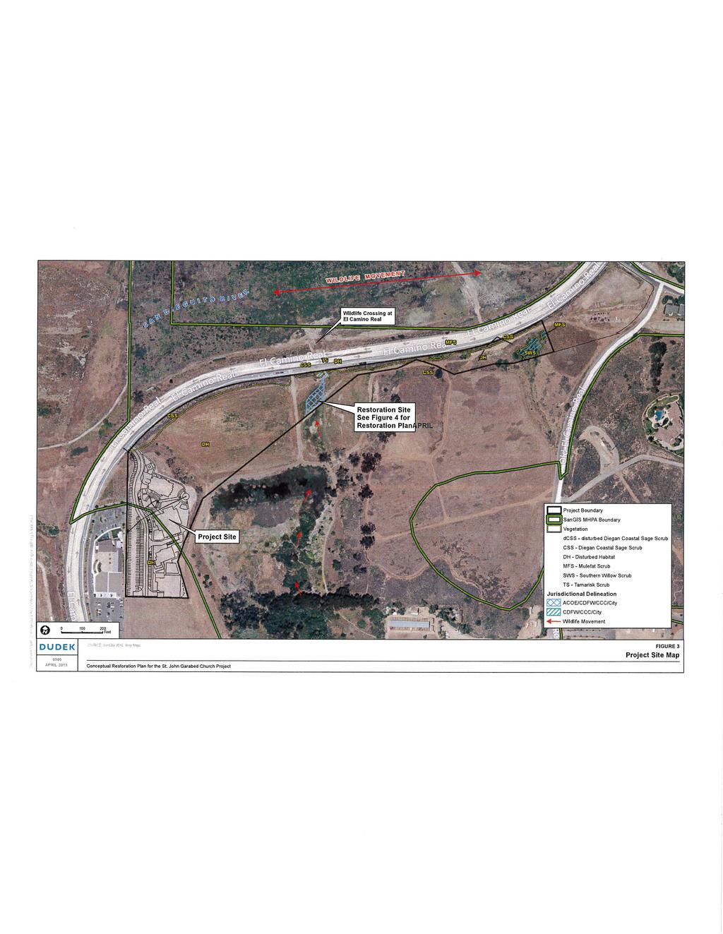
4 Agenda Item 2 July 12, 2013 TO: FROM: SUBJECT: CAC Project Review Committee Status Report of Projects under review in Coastal Area The Project Review Committee has been reviewing two projects that they anticipate bringing to the CAC in the near future for consideration, both of which are located in the coastal area of the San Dieguito River Park Focused Planning Area (FPA). Both are still under review but environmental documentation in the form of CEQA compliance and technical impact studies (such as a biology study) are not yet available. The PRC will bring both projects to the CAC for a recommendation during public review periods. A. St. John Garabed Church The St. John Garabed Armenian Church (Church) project is proposed on a acre site on El Camino Real approximately ½ mile east of Interstate 5 across from the San Dieguito lagoon wetland restoration project (Attachments 1 and 2). The site is directly behind another recently-built church (Formosan) and just north of the Stallions Crossing residential development. The project consists of four proposed structures (church sanctuary, hall, education building and youth center) on a mesa that overlooks an open space corridor connecting Gonzales Canyon to the lagoon. All proposed structures are 28 to 40 feet high and the sanctuary varies from 50 to 85 feet high. The proposed project is under review at the City of San Diego, originally submitted in June 2011, and the PRC and JPA staff has spent considerable time reviewing the project plans, meeting with the applicant, and visiting the site. Two comment letters have been submitted to City staff describing concerns with the project design (Attachments 3 and 4); however, many of the concerns raised have not been adequately addressed. CEQA has not been done yet for this project, but our understanding is an EIR will be prepared. Issues related to this project include its potential impacts on the adjacent wildlife corridor, development within the City s MHPA (habitat preserve), and visual impacts to the river valley. The PRC anticipates bringing this project to the CAC for review and recommendation later this year. B. Via de la Valle Widening Plans As reported at previous meetings, the City is planning to widen Via de la Valle from San Andres to just west of El Camino Real from one lane in each direction to two lanes. The road was required to be widened as mitigation for development in Black Mountain Ranch and the road construction plans have been under review since Initially, the San Dieguito River Park JPA and surrounding community members voiced concerns about the proposed design regarding the road width and amount of hardscape as an impact to 4
5 Agenda Item 2 July 12, 2013 the river valley. Plans to widen El Camino Real were also met with resistance for the same reasons. As a response to those concerns, then council representative Scott Peters convened an ad-hoc task force to examine these issues. JPA and Conservancy staff as well as members of other community organizations participated on the task force. A report was generated in 2007 with recommendations to reduce the proposed width and modify the design of the roadway widening projects to address their impacts on the river valley. Revised plans for Via de la Valle were recently obtained by JPA staff. The PRC has reviewed the plans and found that the width has been reduced and other design modifications have been made to address the concerns raised. The project must still undergo CEQA review and requires a Coastal Permit from the California Coastal Commission; therefore, the PRC will bring the plans to the CAC for a recommendation when a new CEQA document is available. Based on information available, the roadway width is now proposed at 56 feet compared to the 54 feet (both numbers do not include medians) recommended by the task force. The plans also include 6-foot wide bike lanes and a 6-foot wide DG path (in lieu of a sidewalk) on the south side of the road. The center median width has been reduced from what was originally proposed, varying from 4 to 14 feet to allow for turn pockets. The widening would stop short of the intersection with El Camino Real. Attachments: 1. St. John Garabed Church Project Location Map 2. St. John Garabed elevation renderings 3. Comment letter 10/26/11 4. Comment letter 11/13/12 5
6 6 ATTACHMENT 1
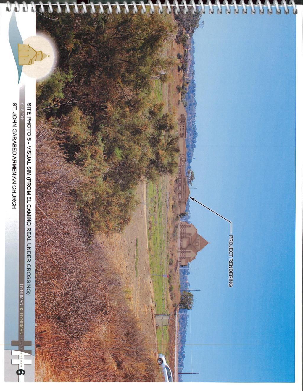
7 7
8 8 ATTACHMENT 2
9 9
10 10
11 11
12 12
13 November 13, 2012 Mr. John Fisher City of San Diego Development Services Dept First Avenue, MS501 San Diego, CA Subject: Comments on Proposed St. John Garabed Church; Project # Dear John: After reviewing the proposed plans for this project as recently resubmitted in September, it appears that few of the issues expressed in our previous comment letter (10/26/11) have been addressed. As previously stated, this project is located in the San Dieguito River Park s FPA on a prominent mesa in the San Dieguito River Valley and thus its location and design is of importance to the JPA. While we appreciate the project s representatives presenting to the JPA s Project Review Committee over the past year, they have not addressed our issues and their project design has changed only minimally. Therefore, the comments stated in our 10/26/11 letter still stand. In summary, the issues that remain of primary concern to the JPA are: The mass and scale of the project is in direct conflict with the San Dieguito River Park Concept Plan and with community planning policies as cited by City staff in their project assessments. The project is not solely a church use, but additional uses housed in a complex of large structures totaling 51,680 square feet that is out-of-scale with the surrounding area representing an over-intensification of use on the property. The proposed MHPA boundary adjustment is excessive since over half of the project encroaches into the existing MHPA. The MHPA was designed to protect the sensitive nature of this area above the Gonzales Canyon floodplain as it flows into the San Dieguito River Valley. The proposed boundary adjustment intrudes into the approved open space preserve on the adjacent Pardee project and isolates an existing mitigation site on the Formosan Church property. The result would create a habitat island next to El Camino Real, not the intension of the MSCP. The proposal would compromise the MHPA in this area. It appears that the church could be accommodated within the existing MHPA boundary without harming the integrity of the MSCP and adjacent wetlands. However, as proposed the project is overbuilt for the site. Adjacent recently- 13
14 Mr. Fisher Page 2 built or approved projects do comply with the MSCP (Pardee s Rancho Valley Farms and the Formosan Church) and this project should as well. Even with a significant encroachment into the MHPA, the project proposes yet more encroachments into the required setbacks. What are the hardships on this property that warrant the zoning code deviations? It does not appear that findings for a deviation could be made. Again, the proposed project is not limited to a church sanctuary but includes a school, hall, and youth center that together represent an intensity of use incompatible with the surrounding open space, sensitive adjacent MHPA land, and the goal to protect the San Dieguito River Valley. The sanctuary represents only 17% of the total square feet. No mitigation is proposed to offset impacts associated with MHPA encroachment and adjacency to a wildlife corridor. This corridor has been recently enhanced by a new wildlife culvert to better facilitate wildlife movement under El Camino Real. What impacts will this project have on the quality of the wildlife corridor from lights, human activity (particularly at night), and noise? Views into the project from surrounding public areas would be significant, dramatically changing the open visually appealing landscape of the river valley. The proposed 51,680 square foot complex of structures would unnecessarily obstruct the views in the river valley. The excessive height of these structures (32 to 40 feet) dwarfs the neighboring Formosan Church and intrudes into the viewshed. These buildings would be seen from several public roads, trails, and a San Dieguito River Park public educational facility to be constructed in 2013 across the valley to the northwest of the project site (open air trailside classroom). The fact that the existing zone allows a maximum height over 30 feet on this site under certain conditions is not the only factor to consider. Policies included in the NCFUA plan, coastal plan, San Dieguito River Park Concept Plan, MSCP, and CUP findings hold equal weight and must be considered. Combined with the newly constructed Formosan church project and the potential for development on the private parcel behind the subject site, cumulative visual impacts would add substantial development in the river valley and adjacent to a wildlife corridor. The entire east side of El Camino Real will be developed with an intensive collection of large buildings and active uses. This would cause cumulatively significant visual and biological impacts that must be addressed. As noted in our previous letter, the subject property abuts an approved trail easement on the Pardee Rancho Valley Farms site. This trail link from Gonzales Canyon is planned to eventually connect to the Coast to Crest Trail. The subject property lies between the Pardee trail easement and El Camino Real and must be crossed in order to reach the new culvert under El Camino Real (proposed as a trail undercrossing). We understand that the applicant is not opposed to a trail on their property but that trail planning and permitting is not part of their project. We would like their project to include a possible easement for the trail although we realize that permit approvals have not yet been obtained for a trail. We would appreciate the opportunity to work with City Parks and Recreation staff on a trail easement proposal. 14
15 Mr. Fisher Page 3 We are disappointed that the most of the issues expressed in our previous letter (now over a year ago) have yet to be addressed by the applicant s project. We appreciate City staff s consideration of the JPA s concerns. Sincerely, Shawna C. Anderson, AICP Environmental Planner Cc: Bernie Turgeon, Development Services Carmel Valley Community Planning Board Marcela Escobar-Eck, Atlantis Group LLC 15
16 Agenda Item 3 July 12, 2013 TO: FROM: SUBJECT: CAC Staff Carmel Valley Planning Area Expansion RECOMMENDATION Discuss and provide recommendation to JPA Board. It has been reported that the Carmel Valley Planning Board will be considering placing the San Dieguito River Valley (East of I-5) under its jurisdiction. Currently the coastal area east of I-5 is not under the jurisdiction of any planning group in the City of San Diego. This situation results from the fact that this area was part of the North City Future Urbanizing Area. It was designated as Subarea II of the NCFUA. As sections of the FUA were transitioned into development, Subarea Plans were prepared for those areas and they were assigned to a planning group. Because a large percentage of the coastal area has been acquired by public agencies for public open space, it will not develop as part of a large development plan as other subareas did, and consequently has fallen into a planning void. There is no Subarea plan for Subarea II, and no review by an official planning group. However, as we know, that does not mean that development will not occur. Examples of development that has been proposed in this area include the Rancho Del Mar project (on the former Hu property) and the St. Garabed Church. The Polo Fields and its uses are also affected by this lack of official planning review. The trail cantilever described in Item 4 of today s agenda is another example. If the boundaries of the Carmel Valley Planning Group are expanded to include Subarea II, it would provide official planning oversight to this area that does not presently exist. 16
17 Agenda Item 4 July 12, 2013 TO: FROM: SUBJECT: CAC Staff Trail Cantilever at El Camino Real Bridge Discuss and make recommendation to JPA Board Background The City of San Diego plans to replace the El Camino Real Bridge in the near future. Alternative alignments have been studied and an EIR is expected to be released this summer. The JPA has proposed that the bridge be constructed with a cantilever on the west side of the bridge for hikers, bicyclists and equestrians. The cantilever would connect trails on the south side of the San Dieguito River with the existing Coast to Crest Trail on the north side of the river. The cantilever will be a critical link for several existing and proposed trails in the area and without it the El Camino Real bridge will remain a barrier for equestrians, families and recreational bicyclists to access the trail system: The San Dieguito River Park Coast to Crest Trail, which is located on the north side of the river, is existing on the west side of El Camino Real (along the State s Horsepark property) and will soon be existing on the east side of El Camino Real along the Polo Fields. The El Camino Real Bridge project includes construction of a trail under the bridge to connect those two segments. On the south side of the river there are several nearby existing trails the Dust Devil Nature Trail on the west side of El Camino Real and the Gonzales Canyon Trail on the east side of Old El Camino Real. Several development projects on property between El Camino Real and Old El Camino Real are in the permitting stage now that are being required to include trails as part of their projects, all designed to connect and lead to the Coast to Crest Trail. SANDAG is planning a major wetland restoration project on property west of El Camino Real. That project will include a multi-use trail along the edge of the property just west of El Camino Real leading up to the El Camino Real bridge. Development Services staff and Parks staff are working with San Dieguito River Park JPA staff to coordinate the planning for all of these trails. For all of these convergent trails to connect and to provide true multi-modal access, it depends on a trail cantilever to be constructed as part of the El Camino Real Bridge. 17
18 Agenda Item 4 July 12, 2013 City engineering staff has confirmed that the Federal funding source for the El Camino Real bridge construction will not pay to include the cantilever because it wasn t part of the original bridge. Other grant sources of construction funds will be necessary. JPA staff would like to have City engineering staff incorporate the design of the cantilever into the design of the bridge, and then for City engineering staff to seek grant funds, such as the SANDAG Active Transportation Grant program, for the construction. This action will likely require the support and direction of the Council District office and the Mayor s office. 18
19 Agenda Item 5 July 12, 2013 TO: FROM: SUBJECT: CAC Staff SCE Wetland Restoration Project status since San Onofre Decommission Decision After the announcement that the San Onofre Nuclear Generating Station would be permanently shut down, Executive Director Bobertz asked JPA Attorney Brechtel how that would affect SCE s responsibilities at the Lagoon and the JPA s agreements with SCE. He responded, The 1991 MOA provides that SCE's maintenance obligations shall "be for a minimum of twenty (20) years, or the operating life of the San Onofre Nuclear Generating Station Units 2 and 3, whichever is longer." The actual permit language defines the operating life to include "the decommissioning period to the extent there are continuing discharges." It appears the operating life of units 2 and 3 is almost 30 years, based upon Coastal Commission reports that state they began operating in 1983 and 1984 respectively. See Attached information sheet. Among questions that may be subject to debate are i) when the SCE maintenance period started, and ii) when Units 2 and 3 became, or will become non-operational and decommissioned. My initial opinion is that SCE's maintenance obligation started in September 2011 when major construction of the wetland restoration project was completed at the inlet opening. At this point, I have no idea if Units 2 and 3 are continuing to discharge such that they would not be considered decommissioned. If we assume for the sake of argument that the units were decommissioned this year, then SCE's maintenance obligation would extend to 2040 [ years = 2040]. Attachment: SONGS Permit Background 19
20 [Songs Units 2 and 3 have been in operation since 1983 and 1984, respectively and shut down in January 2012 = 29 and 28 years respectively] [SONGS was supposed to operate until 2022] [Construction of the wetland restoration project at San Dieguito commenced in August 2006 and was completed on September 29, 2011, with the completion of the inlet opening. ] [ years = 2040] Original SONGS Permit Condition A (Wetland Mitigation), Section 3.0 (Wetland Monitoring, Management and Remediation) of the CCC coastal development permit (CDP A; Formerly ) for SONGS reads as follows: 3.0 WETLAND MONITORING, MANAGEMENT AND REMEDIATION Monitoring, monitoring, management (including maintenance) and remediation shall be conducted over the full operating life of SONGS Units 2 & 3. Full operating life as defined in this permit includes past and future years of operation of SONGS Units 2 and 3 including the the decommissioning period to the extent there are continuing discharges. The number of past operating years at the time the wetland is ultimately constructed, shall be added to the number of future operating years and decommission period, to determine the length of the monitoring, management and remediation requirement. Restoration Plan Permit Condition 10 (CDP ) reads as follows: 10. Maintenance and Management. Maintenance and management of the restoration project components, excluding the five Least Tern Nesting sites, shall be the responsibility of SCE for a period of time equivalent to the full operating life of SONGS Units 2 and 3, as defined in Section 3 of Condition A of CDP # A), after which time SCE shall transfer maintenance and management responsibilities to the JPA in accordance with the 1991 Memorandum of Agreement between SCE and JPA as amended August 1, 2005, except for maintenance of beach access, which shall remain SCE s responsibility. SCE may contract with JPA or another third party (e.g. San Diego County Parks and Recreation Department) to perform SCE s maintenance and management responsibilities prior to transfer to the JPA. Maintenance and management shall be performed as follows: a. Both wetland and upland areas of the restoration shall be maintained to control invasive plants and to assure that native plants become established. b. Inlet maintenance shall be performed in accordance with and as determined through the document titled Restored San Dieguito Lagoon Inlet Channel Initial and Periodic Dredging, dated December 10, 2004, and in accordance with Special Condition #23. 20
21 c. River berms and slope protective works shall be inspected annually between August and November and after major storm events (greater than the 10 year flood with flows overtopping Lake Hodges Dam). After magnitude 5.5 or greater seismic events originating within a 20-mile radius of the project site, inspections shall be made by a hydrologist, restoration specialist and geotechnical engineer, and the results of their determination of any adverse effect shall be provided in writing to the Executive Director. If after inspection, it is apparent repair or maintenance is necessary, the applicants shall contact the Commission office to determine whether permits are necessary. d. The weir located between the Villages Parcel (DS32) and the Horse Park property shall be inspected annually between August and November and after major storm events (greater than the 10 year flood with flows overtopping Lake Hodges Dam) to identify any structural damage. If after inspection, it is apparent repair or maintenance is necessary, the applicants should contact the Commission office to determine whether permits are necessary. Sediment and debris shall be removed from the weir and culverts located in the river berms annually between August and November and after major storm events (greater than the 10 year flood with flows overtopping Lake Hodges Dam). Biofouling organisms (e.g., mussels) shall be removed from the weirs and culverts as needed. e. Active Freshwater runoff treatment ponds 1 and 2 (Northside) shall be maintained by the JPA for water quality treatment purposes by removing vegetation and accumulated sediment no more frequently than annually, but at a minimum of once every three years. Invasive plant material shall be removed annually. No plant material other than invasive species may be removed from the outside or tops of any banks around the ponds. No tree species may be removed unless they are non-native species. Material shall only be removed by hand or by a back-hoe that will reach from the trail surface through the vegetation openings left along the trail edge. f. Passive Freshwater runoff treatment ponds 3 and 4 (Southside) shall be monitored and inspected annually to identify the sustainability and viability of all planted native species. Corrective action shall be conducted within 3 months of this inspection period. Corrective action includes the infill planting of approved species and removal of all non-native or invasive species. g. The maintenance of the Freshwater runoff treatment ponds and achievement of success criteria shall be substantially consistent with the document titled M41 Parcel Treatment Marsh Descriptions submitted 2/11/04 and as revised in accordance with Special Conditions #5 and #8. h. Public access and education components of the restoration project, except for the improved beach access, shall be maintained and managed in accordance with Section Public Access and Park Facility Management Plan in the FRP. i. The existing beach access trail south of the inlet shall be maintained by SCE in its current condition, at a minimum. The access ramp north of the inlet shall be maintained to provide ADA accessible public access from Camino del Mar to the beach at all times. 21
22 SONGS PERMIT BACKGROUND In 1974, the California Coastal Zone Conservation Commission issued a permit (No A, formerly ) to Southern California Edison Company for Units 2 and 3 of the San Onofre Nuclear Generating Station (SONGS). A condition of the permit required study of the impacts of the operation of Units 2 and 3 on the marine environment offshore from San Onofre, and mitigation of any adverse impacts. As a result of the impact studies, in 1991 the Coastal Commission added new conditions to mitigate the adverse impacts of the power plant on the marine environment which require the permittee to: (1) create or substantially restore at least 150 acres of southern California wetlands (Condition A). The 1991 conditions also require SCE to provide the funds necessary for Commission contract scientific staff technical oversight and independent monitoring of the mitigation projects (Condition D). Monitoring, management, and remediation, if needed, are required to be conducted over the full operating life of SONGS, defined as past and future years of operation of SONGS Units 2 and 3, including the decommissioning period to the extent that there are continuing discharges. After extensive review of new kelp impact studies, in April 1997 the Commission approved amended conditions which: (1) reaffirm the Commission s prior decision that San Dieguito is the site that best meets the permit s standards and objectives for wetland restoration, (2) allow up to 35 acres credit for enhancement of wetland habitat at San Dieguito Lagoon by keeping the river mouth permanently open, and (3) revise the kelp mitigation requirements in Condition C. The Commission also found in April 1997 that there is continuing importance for the independent monitoring and technical oversight required in Condition D to ensure full mitigation under the permit. Wetland Restoration Planning and Environmental Review In June 1992, following an evaluation of eight sites, the Commission approved SCE s selected restoration site, the San Dieguito River Valley. In April 1997, the Commission reaffirmed its prior decision that San Dieguito River Valley is the restoration site that meets the minimum standards and best meets the objectives set forth in Condition A. In November 1997, the Commission approved SCE s preliminary wetland restoration plan as largely conforming with the minimum standards and objectives stated in the permit. The CEQA/NEPA environmental review incorporated the mitigation project into the overall San Dieguito River Valley Regional Open Space Park project. Following the review period on the January 2000 Draft EIR/EIS, the JPA certified the Final EIR/EIS on September 15, 2000, after public hearing. Following the conclusion of the litigation, the USFWS issued its final Record of Decision on the Final EIR/EIS on November 28, On October 12, 2005, the Commission approved the Final Restoration Plan and CDP # , as conditioned, for the San Dieguito Wetland Restoration Project. 22
23 Following the Commission s approval of CDP # , SCE and JPA began preparing the final plans in compliance with the special conditions in CDP # that must be met prior to issuance of the permit, prior to commencement of construction, during construction, at the completion of construction, and on an on-going basis. Construction of the wetland restoration project at San Dieguito commenced in August 2006 and was completed on September 29, 2011, with the completion of the inlet opening. A Draft Monitoring Plan for the SONGS Wetland Mitigation Program was reviewed by State and Federal agencies and SCE in May A revised Monitoring Plan was part of the coastal development permit (No ) for the wetland restoration project considered and approved by the Commission on October 12, The Monitoring Plan has subsequently been updated in June and October COMMISSION OVERSIGHT AND INDEPENDENT MONITORING Condition D of the permit establishes the administrative structure to fund the independent monitoring and technical oversight of the mitigation projects. It specifically: (1) enables the Commission to retain contract scientists and technical staff to assist the Commission in carrying out its oversight and monitoring functions, (2) provides for a scientific advisory panel to advise the Commission on the design, implementation, monitoring, and remediation of the mitigation projects, (3) assigns financial responsibility for the Commission s oversight and monitoring functions to the permittee and sets forth associated administrative guidelines, and (4) provides for periodic public review of the performance of the mitigation projects. Condition D requires SCE to fund the Commission s oversight of the mitigation and independent monitoring functions identified in and required by Conditions A through C. The permittee is required to provide reasonable and necessary costs for the Commission to retain personnel with appropriate scientific or technical training and skills, as well as reasonable funding for necessary support personnel, equipment, overhead, consultants, the retention of contractors needed to conduct identified studies, and to defray the costs of members of any scientific advisory panel convened by the Executive Director to provide advice on the design, implementation, monitoring and remediation of the mitigation projects. 23
24 Agenda Item 6 July 12, 2013 TO: FROM: SUBJECT: CAC Staff Update on Water Level in Lake Hodges Gina Molise (public outreach at the SD County Water Authority) has explained that the situation regarding the Hodges current low lake level is driven by legal agreements between CWA and the City of San Diego (which owns and operates several of the reservoirs in San Diego including Hodges) worked out years ago when the emergency storage project was first developed. The low lake level at Hodges is due primarily to two factors: the low rainfall we had this past winter that did not fill up the lake (the lake's topography and shape is such that it fills and lowers very quickly), and agreements that state that CWA cannot use Hodges for emergency storage until the San Vicente dam project is completed (2014). The SV dam is being raised (heightened) to allow greater emergency storage at San Vicente (also owned by City of San Diego). While that project is being constructed, the CWA does not have "emergency water storage rights" at Hodges. The pipeline and pump between Olivenhain and Hodges is complete and operating but water is only being transferred at a minimal rate just to keep the pumps working and the electricity generating (SDG&E has a new station there) until the San Vicente Dam project is done. Ms. Molise did not know why the agreement doesn't allow Hodges to be full while San Vicente is low during the dam construction project. This provision seems counterproductive considering the whole point is to store water (i.e, currently both reservoirs are at low level). She said she would inquire and get back to JPA staff. If we have new information it will be reported at today s meeting. She explained that CWA and the City are discussing changing the operating details regarding emergency storage so there may be more changes to come later this year. 24
Agenda Item 1.a.i. April 4, 2014
 Agenda Item 1.a.i. April 4, 2014 TO: FROM: SUBJECT: CAC Project Review Committee and JPA staff St. John Garabed Church Project Comments on Draft EIR PRC RECOMMENDATION: Request that JPA send Draft EIR
AGENDA SAN DIEGUITO RIVER VALLEY REGIONAL OPEN SPACE PARK CITIZENS ADVISORY COMMITTEE. 10:30 a.m. to 12:15 p.m. Friday, June 1, 2007
 AGENDA SAN DIEGUITO RIVER VALLEY REGIONAL OPEN SPACE PARK CITIZENS ADVISORY COMMITTEE 10:30 a.m. to 12:15 p.m. Friday, June 1, 2007 Hope United Methodist Church, Covenant Hall 16550 Bernardo Heights Parkway
CHAPTER 5.0 ENVIRONMENTAL IMPACT ANALYSIS
 CHAPTER 5.0 ENVIRONMENTAL IMPACT ANALYSIS Chapter 5 contains an analysis of the potential environmental impacts that may occur through implementation of the proposed project, including anticipated future
Memorandum Planning. Thursday, January 8, 2015
 Memorandum Planning Thursday, January 8, 2015 7.A. To: Coastal Advisory Committee From John Ciampa, Associate Planner Subject: Review Draft Local Coastal Program Copies: James Pechous, City Planner Purpose
NOTICE OF PREPARATION
 NOTICE OF PREPARATION To: All Interested Parties Subject: Notice of Preparation of an Environmental Impact Report From: City of Petaluma Address: 11 English Street, Petaluma, CA 94952-2610 Contact: Heather
WELCOME! 8 8:30 6: TH STREET IMPROVEMENTS. Open House. Presentation & Q&A
 WELCOME! 168 TH STREET IMPROVEMENTS 6:30 Open House 7 8 Presentation & Q&A 8 8:30 Open House WELCOME Todd Pfitzer City of Omaha Engineer Bob Stubbe City of Omaha Public Works Director Jon Meyer Project
San Diego River Coalition 2012 Work Plan
 San Diego River Coalition 2012 Work Plan Adopted November 18, 2011 The mission of the San Diego River Coalition is preserve and enhance the San Diego River, its watershed, and its natural, cultural and
2.1.8 Cultural Resources Regulatory Setting. Affected Environment, Environmental
 REVISED DRAFT ENVIRONMENTAL IMPACT REPORT/ Affected Environment, Environmental 2.1.8 Cultural Resources This section evaluates the potential for historical and archaeological resources within the proposed
ARROYO PROJECTS ADOPTED CAPITAL IMPROVEMENT PROGRAM BUDGET
 A RROYO P ROJECTS ADOPTED CAPITAL IMPROVEMENT PROGRAM BUDGET FISCAL YEARS 214-218 HAHAMONGNA Priority Description 1 Hahamongna Watershed Park - Implement Master Plan 211,6 211,6 (77565) 2 Hahamongna -
Glenborough at Easton Land Use Master Plan
 Implementation 114 9.0 IMPLEMENTATION 9.1 OVERVIEW This chapter summarizes the administrative procedures necessary to implement the proposed land use plan, infrastructure improvements, development standards,
Meeting Agenda. City of Guelph. River Systems Advisory Committee. Agenda Items. Item 1, 2 and 3. Item 4 Ward to Downtown Pedestrian Bridge
 Meeting Agenda City of Guelph River Systems Advisory Committee September 19, 2018 City Hall, Meeting Room B From 4:00 to 6:00 p.m. Meeting Chair: Mariette Pushkar Agenda Items Welcome to all Item 1, 2
MATHEMATICAL SCIENCES BUILDING
 Final Focused Tiered Environmental Impact Report State Clearinghouse No. 2002072048 Prepared By: OFFICE OF RESOURCE MANAGEMENT AND PLANNING University of California One Shields Avenue 376 Mrak Hall Davis,
Town of Portola Valley General Plan. Nathhorst Triangle Area Plan
 Town of Portola Valley General Plan Amended December 10, 1997 Table of Contents Introduction... 1 Planning Area... 1 Objectives... 2 Principles... 2 Standards... 4 Description... 4 Community Commercial...
The Illinois Department of Transportation and Lake County Division of Transportation. Route 173, including the Millburn Bypass
 The Illinois Department of Transportation and Lake County Division of Transportation welcome you to this Public Hearing for U.S. Route 45 from Illinois Route 132 to Illinois Route 173, including the Millburn
SECTION 4(f) DE MINIMIS DOCUMENTATION
 DE MINIMIS DOCUMENTATION") SECTION 4(f) DE MINIMIS DOCUMENTATION Illinois Route 60/83 IL 176 to the intersection of IL 60 (Townline Road) Lake County P-91-084-07 Mundelein Park and Recreation District Project Limit SECTION 4(f)
SECTION 4(f) DE MINIMIS DOCUMENTATION Illinois Route 60/83 IL 176 to the intersection of IL 60 (Townline Road) Lake County P-91-084-07 Mundelein Park and Recreation District Project Limit SECTION 4(f)
PUBLIC HEARING. Thursday, December 14, 2017 FDOT Urban Office 2198 Edison Avenue Jacksonville, FL 32204
 DISTRICT TWO PUBLIC HEARING I 10 (SR 8) from I 295 to I 95 Project Development & Environment Study Duval County, Florida Financial Project Number 213326 2 22 01 Efficient Transportation Decision Making
Report to City Council
 Attachment 4 BUDGET OFFICER CITY ATTORNEY APPROVALS CITY MANAGER Report to City Council TO: FROM: Mayor and City Council John C. Terell, Community and Economic Development Director AGENDA DATE: June 24,
Drexel, Barrell & Co.
 Drexel, Barrell & Co. June 18, 2018 Engineers/Surveyors Boulder Colorado Springs Greeley 3 South 7 th Street Colorado Springs, Colorado 80905-1501 719 260-0887 719 260-8352 Fax El Paso County Planning
Public Review Draft Oceanside Subarea Habitat Conservation Plan/ Natural Communities Conservation Plan
 Oceanside Subarea Habitat Conservation Plan/ Natural Communities Conservation Plan Prepared for City of Oceanside Planning Department 300 N. Coast Highway Oceanside, CA 92054 Prepared by Ogden Environmental
DRAFT MAP AMENDMENT FLU 04-4
 DRAFT MAP AMENDMENT FLU 04-4 SW 24 TH AVENUE ROADWAY CORRIDOR The University of Florida participates with the Metropolitan Transportation Planning Organization (MTPO) in its responsibilities for the continuing,
PLANNED UNIT DEVELOPMENT STAFF REPORT Date: June 2, 2016
 # 9 ZON2016-01032 PLANNED UNIT DEVELOPMENT STAFF REPORT Date: June 2, 2016 DEVELOPMENT NAME JJT Properties LLC LOCATION 1147 & 1151 East I-65 Service Road South and 1180 Sledge Drive (Southeast corner
Green Oak Charter Township. Planning Commission Regular Meeting Minutes August 4, 2016
 1 2 3 4 5 6 7 8 9 10 11 12 13 14 15 16 17 18 19 20 21 22 23 24 25 26 27 28 29 30 31 32 33 34 35 36 37 38 39 40 41 42 43 44 45 46 47 48 49 Planning Commission Regular Meeting Minutes August 4, 2016 The
PROJECT BACKGROUND. Preliminary Design Scope and Tasks
 PROJECT BACKGROUND Preliminary Design Scope and Tasks The purpose of this Study is the development of preliminary designs for intersection improvements for Trunk Highway (TH) 36 at the intersections of
ADOPTED CAPITAL IMPROVEMENT PROGRAM BUDGET ARROYO PROJECTS
 ADOPTED CAPITAL IMPROVEMENT PROGRAM BUDGET ARROYO PROJECTS HAHAMONGNA FY 212-216 Capital Improvement Program Priority Description Total Estimated Costs Appropriated Through FY 211 Adopted FY 212 FY 213
Drexel, Barrell & Co.
 Drexel, Barrell & Co. December 21, 2018 Engineers/Surveyors Boulder Colorado Springs Greeley 3 South 7 th Street Colorado Springs, Colorado 80905-1501 719 260-0887 719 260-8352 Fax El Paso County Planning
City of Del Mar. Del Mar Resort Specific Plan Environmental Impact Report Notice of Preparation
 City of Del Mar Del Mar Resort Specific Plan Environmental Impact Report Notice of Preparation Date: September 9, 07 To: From: Subject: State Clearinghouse, Responsible Agencies, Trustee Agencies, Interested
SUBJECT: Comments on Del Mar Fairgrounds Master Plan Draft Environmental Impact Report
 Dustin Fuller, Sr. Environmental Planner 22 nd District Agricultural Association Del Mar Fairgrounds 2260 Jimmy Durante Boulevard Del Mar, CA 92014-2216 February 5, 2010 SUBJECT: Comments on Del Mar Fairgrounds
SBCAG STAFF REPORT. MEETING DATE: March 17, 2016 AGENDA ITEM: 5I
 SBCAG STAFF REPORT SUBJECT: Cabrillo-UPRR Bridge Project MEETING DATE: March 17, 2016 AGENDA ITEM: 5I STAFF CONTACT: Fred Luna RECOMMENDATION: Authorize the chair to sign a Memorandum of Understanding
Approved: CITY OF ARDEN HILLS, MINNESOTA PLANNING COMMISSION WEDNESDAY, AUGUST 5, :30 P.M. - ARDEN HILLS CITY HALL
 Approved: CITY OF ARDEN HILLS, MINNESOTA PLANNING COMMISSION WEDNESDAY, AUGUST 5, 2015 6:30 P.M. - ARDEN HILLS CITY HALL PLANNING CASES A. Planning Case 15-016; Final Planned Unit Development Arden Plaza;
STREAM BUFFERS
 88-415 STREAM BUFFERS 88-415-01 PURPOSE In the Kansas City region and throughout the nation, vegetated stream buffers have been clearly shown to protect stream stability and related infrastructure, improve
CHAPTER 2 SUMMARY 1. PROJECT SUMMARY DATA
 CHAPTER 2 SUMMARY This is an Initial Study format used to determine, pursuant to CEQA Guidelines Section 15177, whether a project 1) is within the scope of a Master EIR (MEIR), 2) may result in additional
STAFF REPORT TO THE CITY COUNCIL. Conduct Public Hearing to vacate certain public right of way adjacent to Sycamore Avenue and San Pablo Avenue
 STAFF REPORT TO THE CITY COUNCIL DATE: Adjourned Regular Meeting of December 16, 2014 TO: SUBMITTED BY: SUBJECT: Mayor and Members of the City Council Holly Smyth, Planning Director Conduct Public Hearing
CONSENT CALENDAR CITY PLANNING COMMISSION AGENDA ITEM NO: A.1, A.2 STAFF: LARRY LARSEN
 Page 8 CONSENT CALENDAR CITY PLANNING COMMISSION AGENDA ITEM NO: A.1, A.2 STAFF: LARRY LARSEN FILE NO: CPC PUZ 14-00013 - QUASI-JUDICIAL FILE NO: CPC PUD 14-00014 QUASI-JUDICIAL PROJECT: APPLICANT: OWNER:
4/8/2015 Item #10D Page 1
 MEETING DATE: April 8, 2015 PREPARED BY: Christy Villa, Associate Civil Engineer DEPT. DIRECTOR: Glenn Pruim DEPARTMENT: Public Works CITY MANAGER: Larry Watt SUBJECT: NORTH COAST HIGHWAY 101 STREETSCAPE
Pine Flat Lake Master Plan Update FACT SHEET September 2014
 Pine Flat Lake Master Plan Update FACT SHEET September 2014 PURPOSE AND OBJECTIVE The U.S. Army Corps of Engineers Sacramento District is revising the 1976 Pine Flat Lake Master Plan and is seeking public
City of Westbrook. 2 York Street Westbrook, Maine (207) Fax:
 Fax:") City of Westbrook DEPARTMENT OF PLANNING & CODE ENFORCEMENT 2 York Street Westbrook, Maine 04092 (207) 854-0638 Fax: 1-866-559-0642 WESTBROOK PLANNING BOARD TUESDAY, JANUARY 2, 2018, 7:00 P.M. WESTBROOK
City of Westbrook DEPARTMENT OF PLANNING & CODE ENFORCEMENT 2 York Street Westbrook, Maine 04092 (207) 854-0638 Fax: 1-866-559-0642 WESTBROOK PLANNING BOARD TUESDAY, JANUARY 2, 2018, 7:00 P.M. WESTBROOK
CHAPTER 10 AESTHETICS
 CHAPTER 10 AESTHETICS CHAPTER 10 AESTHETICS This section identifies and evaluates key visual resources in the project area to determine the degree of visual impact that would be attributable to the project.
AGENDA ITEM: IOWA. west] that were not FISCAL IMPACT. the City of Clive. STAFF REVIEW. Resolution II. Amendment PREPARED BY: REVIEWED BY:
![AGENDA ITEM: IOWA. west] that were not FISCAL IMPACT. the City of Clive. STAFF REVIEW. Resolution II. Amendment PREPARED BY: REVIEWED BY:](/thumbs/93/112428810.jpg "AGENDA ITEM: IOWA. west] that were not FISCAL IMPACT. the City of Clive. STAFF REVIEW. Resolution II. Amendment PREPARED BY: REVIEWED BY:") AGENDA ITEM: CITY OF WAUKEE, IOWA CITY COUNCIL MEETING COMMUNICATION MEETING DATE: March 7, 2016 AGENDA ITEM: Consideration of approval of a resolution approving Engineering Services Amendment No. 1 with
AGENDA ITEM: CITY OF WAUKEE, IOWA CITY COUNCIL MEETING COMMUNICATION MEETING DATE: March 7, 2016 AGENDA ITEM: Consideration of approval of a resolution approving Engineering Services Amendment No. 1 with
OVERMOUNTAIN VICTORY TRAIL BURKE CALDELL CORRIDOR FEASIBLITY STUDY REQUEST FOR QUALIFICATIONS CALDWELL COUNTY PATHWAYS
 OVERMOUNTAIN VICTORY TRAIL BURKE CALDELL CORRIDOR FEASIBLITY STUDY REQUEST FOR QUALIFICATIONS CALDWELL COUNTY PATHWAYS Caldwell County Pathways along with our co-partners City of Lenoir, Town of Gamewell,
PG&E WINTERS GAS OPERATIONS AND TECHNICAL TRAINING CENTER
 PG&E WINTERS GAS OPERATIONS AND TECHNICAL TRAINING CENTER CEQA scoping Meeting March 19 th, 2014 Winters City Council Chambers - 6:30 pm AGENDA FOR THE MEETING 6:30 Welcome (John Donlevy) 6:40 Overview
The West Vaughan Employment Area Secondary Plan Policies
 Part 2: The West Vaughan Employment Area Secondary Plan Policies 2.1 General Policies It is the policy of Council: 2.1.1. That the West Vaughan Employment Area (the WVEA), identified on Schedule 1, will
7th Avenue Creek Master Plan Development Project. City of St. Charles, IL. IAFSM CONFERENCE March 14, 2018 MARKET
 7th Avenue Creek Master Plan Development Project MARKET City of St. Charles, IL IAFSM CONFERENCE March 14, 2018 7 TH AVENUE CREEK PROJECT AREA 2 2008 RAIN EVENT 3 RESIDENTIAL STRUCTURE FLOODING COMMERCIAL
[FWS R8 R 2015 N087; FXRS282108E8PD0 156 F ] South Bay Salt Pond Restoration Project, Phase 2; Don Edwards National Wildlife
![[FWS R8 R 2015 N087; FXRS282108E8PD0 156 F ] South Bay Salt Pond Restoration Project, Phase 2; Don Edwards National Wildlife](/thumbs/84/90602803.jpg "[FWS R8 R 2015 N087; FXRS282108E8PD0 156 F ] South Bay Salt Pond Restoration Project, Phase 2; Don Edwards National Wildlife") Surname Billing Code: 4310 55 Deputy RD ARD Refuges DEPARTMENT OF THE INTERIOR Fish and Wildlife Service Solicitor Refuge Supervisor Asst. Refuge Supervisor Ch. Natural Resources Project Leader [FWS R8
Surname Billing Code: 4310 55 Deputy RD ARD Refuges DEPARTMENT OF THE INTERIOR Fish and Wildlife Service Solicitor Refuge Supervisor Asst. Refuge Supervisor Ch. Natural Resources Project Leader [FWS R8
Shoreline Master Program Town of La Conner, Washington
 Shoreline Master Program Town of La Conner, Washington Department of Ecology approval effective Adopted September 24, 2013 by Town of La Conner Ordinance No.1106 Amended May 13, 2014 by Town of La Conner
WASHINGTON COUNTY OREGON
 WASHINGTON COUNTY OREGON LONG RANGE PLANNING DIVISION North Bethany Subarea Stream Corridors: Existing Regulations In Oregon, there is a distinct difference between the land use rules that apply in rural
Planning Commission Report
 Planning Commission Report To: From: Subject: Planning Commission Meeting: January 6, 2016 Agenda Item: 8-B Planning Commission David Martin, Planning & Community Development Director Introduction to the
PARISH OF ASCENSION OFFICE OF PLANNING AND DEVELOPMENT PLANNING DEPARTMENT. Joint Planning and Zoning Meeting
 1. Call To Order 2. Roll Call of Members 3. Chairman's Comments PARISH OF ASCENSION OFFICE OF PLANNING AND DEVELOPMENT PLANNING DEPARTMENT Joint Planning and Zoning Meeting January 11, 2017 6:00 PM Courthouse
I Street, Sacramento, CA
 REPORT TO PLANNING COMMISSION City of Sacramento 12 915 I Street, Sacramento, CA 95814-2671 To: Members of the Planning Commission PUBLIC HEARING March 10, 2011 Subject: El Dorado Savings Sign Variance
CITY OF MAPLE GROVE PLANNING COMMISSION AGENDA SEPTEMBER 12, :00 P.M.
 CITY OF MAPLE GROVE PLANNING COMMISSION AGENDA SEPTEMBER 12, 2016 7:00 P.M. 1. OPENING BUSINESS A. Call to Order B. Pledge of Allegiance C. Roll Call 2. ADDITIONS OR DELETIONS TO AGENDA Any Commissioner
5.13 RECREATION / OPEN SPACE
 5.13 RECREATION / OPEN SPACE The project includes the development of two 5+ acre public parks, four pocket parks and various trails. This complies with the Board of Supervisors established minimum standard
Public Hearing. Charlotte County-Punta Gorda MPO - Meeting Rooms A and B March 14, open house at 4 p.m., formal presentation at 5 p.m.
 Public Hearing Charlotte County-Punta Gorda MPO - Meeting Rooms A and B March 14, 2019 open house at 4 p.m., formal presentation at 5 p.m. Welcome to the Public Hearing for the Harborview Road (CR 776)
Secrest Short Cut and Monroe Expressway Small Area Plan AUGUST 29, 2018
 Secrest Short Cut and Monroe Expressway Small Area Plan AUGUST 29, 2018 Background and Process Monroe Expressway will be open by the end of 2018 Union County and Indian Trail identified a need to revisit
Asbury Chapel Subdivision Sketch Plan
 Asbury Chapel Subdivision Sketch Plan PART 1: PROJECT SUMMARY Applicant: NVR Inc. Project Size: +/- 76.13 acres Parcel Numbers: 02101112,02116101,02116112, 02116113 Current Zoning: Transitional Residential
12 February 9, 2011 Public Hearing APPLICANT: WILDLIFE RESPONSE, INC.
 12 February 9, 2011 Public Hearing APPLICANT: WILDLIFE RESPONSE, INC. PROPERTY OWNER: CITY OF VIRGINIA BEACH REQUEST: Conditional Use Permit (Wildlife Rehabilitation Center) STAFF PLANNER: Karen Prochilo
Table of Contents TABLE OF CONTENTS SECTION TITLE PAGE
 TABLE OF CONTENTS SECTION TITLE PAGE 1 INTRODUCTION AND OVERVIEW 1-1 1.1 Purpose and Need 1-1 1.2 Goals and Objectives 1-3 1.3 Overview of the Planning Process 1-5 1.4 Federal and State Requirements and
City of Larkspur. Notice of Mitigated Negative Declaration for the 285
 Notice of Mitigated Negative Declaration for the 285 Magnolia Avenue Mixed-Use Project Date: December 2, 2013 Responsible Agency: Project Title: 285 Magnolia Avenue Mixed-Use Project Project Address: 285
NOTICE OF PREPARATION
 NOTICE OF PREPARATION DATE: January 6, 2016 TO: LEAD AGENCY: Responsible Agencies, Organizations, and Interested Parties Contact: Tyler Barrington, Principal Planner Planning Department Community Development
Request for Statement of Interest in Implementation of the Roosevelt Road Redevelopment Plan
 425 Hillside Avenue Request for Statement of Interest in Implementation of the Roosevelt Road Redevelopment Plan I. INTRODUCTION The is seeking the services of a qualified consulting firm to prepare plans
Right-of-Way Acquisitions and Relocations Technical Memorandum
 Right-of-Way Acquisitions and Relocations Technical Memorandum Southeast Extension Project Lincoln Station to RidgeGate Parkway Prepared for: Federal Transit Administration Prepared by: Denver Regional
Venice Pumping Plant Dual Force Main Project Draft EIR
 City of Los Angeles 5.9 LAND USE PLANS 5.9.1 Environmental Setting Venice Pumping Plant Dual Force Main Project Draft EIR The Project lies within the bounds of Los Angeles County and the City of Los Angeles.
3.10 LAND USE SETTING PROJECT SITE EXISTING LAND USE DESIGNATIONS AND ZONING. General Plan Land Use Designations.
 This section of the Draft EIR addresses the existing land uses on and adjacent to the project site and discusses the potential impacts of the proposed project on existing land uses. Key issues addressed
PROJECT STATEMENT LOCATION/DESIGN PUBLIC HEARING. 19 th AVENUE NORTH EXTENSION PROJECT FROM SPRINGDALE DRIVE TO NORTH 2 ND STREET/U.S.
 PROJECT STATEMENT LOCATION/DESIGN PUBLIC HEARING 19 th AVENUE NORTH EXTENSION PROJECT FROM SPRINGDALE DRIVE TO NORTH 2 ND STREET/U.S. 67 HEARING LOCATION: ERICKSEN COMMUNITY CENTER 1401 11 TH AVENUE NORTH
ARLINGTON COUNTY, VIRGINIA. County Board Agenda Item Meeting of January 28, 2017 SUPPLEMENTAL REPORT-2
 ARLINGTON COUNTY, VIRGINIA County Board Agenda Item Meeting of January 28, 2017 SUPPLEMENTAL REPORT-2 DATE: January 27, 2017 SUBJECT: The Virginia Department of Transportation s Transform I-66 Inside the
Notice of Preparation of an Environmental Impact Report and Scoping Meeting for the Canyon Lane Roadway Improvements Development Project
 of an Environmental Impact Report and Scoping Meeting for the As the Lead Agency, the County of San Mateo (County) will prepare an Environmental Impact Report (EIR) for the (project), and would like your
Subject: Hendry County Evaluation and Appraisal Report Letter of Understanding - Identification of Major Issues
 HENDRY COUNTY PLANNING & ZONING DEPARTMENT POST OFFICE BOX 2340 165 S. LEE STREET LABELLE, FLORIDA 33975 (863) 675-5240 FAX: (863) 675-5317 SUNCOM 744-4750 November 16, 2007 Mr. Mike McDaniel, Chief Office
RESOLUTION NO. R Refining the route, profile and stations for the Downtown Redmond Link Extension
 RESOLUTION NO. R2018-32 Refining the route, profile and stations for the Downtown Redmond Link Extension MEETING: DATE: TYPE OF ACTION: STAFF CONTACT: Capital Committee Board PROPOSED ACTION 09/13/2018
PURPOSE: The purpose is to provide commercial facilities in the Vancouver and Clark County vicinity.
 US Army Corps of Engineers Seattle District Joint Public Notice Application for a Department of the Army Permit and a Washington Department of Ecology Water Quality Certification and/or Coastal Zone Management
Staff Report. Conditional Use PLANNING DIVISION COMMUNITY & ECONOMIC DEVELOPMENT. Salt Lake City Planning Commission
 Staff Report PLANNING DIVISION COMMUNITY & ECONOMIC DEVELOPMENT To: From: Salt Lake City Planning Commission Maryann Pickering, Principal Planner (801) 535-7660 Date: December 10, 2014 Re: Church of Scientology
Watertown City Council
 City of Watertown Watertown City Council April 14 th, 2015 Agenda Item: City Comment on Sun Share CUP Application Request for Action: Motion to Approve City Comments regarding CUP Application Department:
Presentation Item C Annotated Model Outline for a Framework for a Green Infrastructure Plan
 Date: August 17, 2016 To: From: Subject: Management Committee Dan Cloak, Consultant Presentation Item C Annotated Model Outline for a Framework for a Green Infrastructure Plan Recommendation: Receive the
ARLINGTON COUNTY, VIRGINIA. County Board Agenda Item Meeting of January 28, 2017 SUPPLEMENTAL REPORT
 ARLINGTON COUNTY, VIRGINIA County Board Agenda Item Meeting of January 28, 2017 SUPPLEMENTAL REPORT DATE: January 26, 2017 SUBJECT: The Virginia Department of Transportation s Transform I-66 Inside the
REQUEST FOR COUNCIL ACTION 6A AGENDA ITEM
 DATE REQUEST FOR COUNCIL ACTION 6A AGENDA ITEM ORIGINATING DEPT. AGENDA ITEM CITY ADMINISTRATOR APPROVAL Community Development PUD Concept & Development Stage Plan Preliminary Plat & Final Plat PREVIOUS
Parks, Trails, and Open space Element
 Parks, Trails, and Open space Element Parks, Trails, and Open Space element Parks, Recreation, and Open Space are important components of the quality of life desired by the residents of Elk Grove. This
ADOPTION OF THE REVISED OPEN SPACE AND CONSERVATION ELEMENT OF THE GENERAL PLAN
 TO: FROM: SUBJECT: Honorable Mayor and City Council Planning Department ADOPTION OF THE REVISED OPEN SPACE AND CONSERVATION ELEMENT OF THE GENERAL PLAN RECOMMENDATION: It is recommended that the City Council:
River Corridor Overlay Zone (RCOZ) Article 5
 Article 5") River Corridor Overlay Zone (RCOZ) Article 5 The site is in one of two designated districts. The first is the CBD (central business district) River District, which recognizes the urban character and unique
River Corridor Overlay Zone (RCOZ) Article 5 The site is in one of two designated districts. The first is the CBD (central business district) River District, which recognizes the urban character and unique
PLANNING COMMISSION Work Session Meeting Agenda
 PLANNING COMMISSION Work Session Meeting Agenda 5200 85TH AVENUE NORTH BROOKLYN PARK MN 55443 PHONE (763) 424-8000 FAX (763) 493-8391 Wednesday, September 27, 2017-7:00 P.M. Brooklyn Township Room If due
CITY PLANNING COMMISSION AGENDA ITEM: C STAFF: ROBERT TEGLER FILE NO: CPC PUD QUASI-JUDICIAL
 CPC AGENDA June 8, 2006 Page 37 CITY PLANNING COMMISSION AGENDA ITEM: C STAFF: ROBERT TEGLER FILE NO: CPC PUD 05-294 - QUASI-JUDICIAL PROJECT: APPLICANT: OWNER: PARKWOOD AT WOLF RANCH NASS DESIGN ASSOCIATES
Existing Conditions and Environmental Consequences Floodplains
 3.9 Environmental Consequences 3.8 3.8.1 WHAT ARE FLOODPLAINS? are low-lying areas adjacent to rivers, streams, and other waterbodies that are susceptible to inundation (flooding) during rain events. These
A. INTRODUCTION B. PROJECT LOCATION
 Chapter 1: Project Description A. INTRODUCTION The Lower Manhattan Development Corporation (LMDC), a subsidiary of the New York State Urban Development Corporation, doing business as the Empire State Development
CHAIR AND MEMBERS PLANNING & ENVIRONMENT COMMITTEE GEORGE KOTSIFAS MANAGING DIRECTOR, DEVELOPMENT & COMPLIANCE SERVICES & CHIEF BUILDING OFFICIAL
 TO: CHAIR AND MEMBERS PLANNING & ENVIRONMENT COMMITTEE FROM: SUBJECT: GEORGE KOTSIFAS MANAGING DIRECTOR, DEVELOPMENT & COMPLIANCE SERVICES & CHIEF BUILDING OFFICIAL APPLICATION BY: 2261531 ONTARIO LIMITED
R E S O L U T I O N. Single-Family Residence/ Church. 2,488 sq. ft. 2,488 sq. ft. Area Parking Required: Church
 R E S O L U T I O N WHEREAS, the Prince George s County Planning Board is charged with the approval of Detailed Site Plans pursuant to Part 3, Division 9 of the Zoning Ordinance of the Prince George s
Understanding Drainage Options What s Feasible and Legal. February 2019
 Understanding Drainage Options What s Feasible and Legal February 2019 Outline for the Presentation Do you need a permit? Does common law apply? Does local government approve it? Will my neighbor allow
STAFF REPORT FOR STANDARD COASTAL DEVELOPMENT PERMIT #CDP FEBRUARY 26, 2015 CPA - 1 PO BOX 238 APTOS, CA 94001
 STAFF REPORT FOR STANDARD COASTAL DEVELOPMENT PERMIT #CDP 2014-0030 FEBRUARY 26, 2015 CPA - 1 OWNER/APPLICANT: AGENT: REQUEST: HANS HEIM PO BOX 238 APTOS, CA 94001 JAMES HAY PO BOX 762 MENDOCINO, CA 95460
Chesapeake Bay Critical Area Conservation Plan
 The Maryland-National Capital Park and Planning Commission Prince George s County Planning Department Development Review Division 301-952-3530 Note: Staff reports can be accessed at www.mncppc.org/pgco/planning/plan.htm.
UNIVERSITY OF CALIFORNIA, SAN DIEGO
 UNIVERSITY OF CALIFORNIA, SAN DIEGO BERKELEY DAVIS IRVINE LOS ANGELES MERCED RIVERSIDE SAN DIEGO SAN FRANCISCO SANTA BARBARA SANTA CRUZ CAMPUS PLANNING 9500 GILMAN DRIVE # 0074 TEL: (858) 534 6515 LA JOLLA,
PARTF Scoring System for Grants
 PARTF Scoring System for Grants The members of the N.C. Parks and Recreation Authority use the PARTF scoring system as one of several tools to select grant recipients. Please provide all of the information
Philip A. Ginsburg, General Manager Dawn Kamalanathan, Director, Planning and Capital Projects
 Date August 5, 2015 To: Through: From: Subject: Recreation and Park Commission Capital Committee Philip A. Ginsburg, General Manager Dawn Kamalanathan, Director, Planning and Capital Projects Nicole Avril,
LOS ANGELES CITY PLANNING DEPARTMENT STAFF REPORT
 LOS ANGELES CITY PLANNING DEPARTMENT STAFF REPORT LOS ANGELES CITY PLANNING COMMISSION CASE NO: CPC 2006-9374 CRA CEQA: Exempt DATE: December 21, 2006 Location: Valley Plaza and Laurel Plaza TIME: after
Staff Report and Recommendation
 Community Planning and Development Planning Services 201 W. Colfax Ave., Dept. 205 Denver, CO 80202 p: 720.865.2915 f: 720.865.3052 www.denvergov.org/cpd TO: City Council Neighborhoods and Planning Committee
RECOMMENDATION REPORT
 DEPARTMENT OF CITY PLANNING RECOMMENDATION REPORT City Planning Commission Case No.: CPC-2012-1165-GPA-ZC Date: August 9, 2012 Time: After 8:30 AM Place: City Hall, Room 350 Public Hearing: Required CEQA
BEFORE THE HEARINGS EXAMINER FOR THURSTON COUNTY
 COUNTY COMMISSIONERS Cathy Wolfe District One Diane Oberquell District Two Robert N. Macleod District Three HEARING EXAMINER BEFORE THE HEARINGS EXAMINER FOR THURSTON COUNTY In the Matter of the Application
Dwelling Units Max 12 dwelling units per acre/min 8 dwelling units per acre. Development Mix 80% non residential/20% residential
 13. OSTEEN LOCAL PLAN Background: The Osteen Local Plan area is located in southwest Volusia County along the SR 415 corridor between Lemon Bluff Road and Acorn Lake Road and includes 3,990 acres. The
Appendix G Response to Comments
 Appendix G Response to Comments This appendix contains the comments received during the public circulation and comment period (May 27, 2008 to July 11, 2008). The comments have been numbered (Comment Set
LAND USE AMENDMENT DOWNTOWN COMMERCIAL CORE (WARD 7) MACLEOD TRAIL SE AND 5 AVENUE SE BYLAW 254D2017
 MACLEOD TRAIL SE AND 5 AVENUE SE BYLAW 254D2017") Page 1 of 10 EXECUTIVE SUMMARY This Land Use Amendment application seeks to redesignate a full downtown block (currently the YWCA site) from a Direct Control based on the CM-2 District (Land Use Bylaw
Page 1 of 10 EXECUTIVE SUMMARY This Land Use Amendment application seeks to redesignate a full downtown block (currently the YWCA site) from a Direct Control based on the CM-2 District (Land Use Bylaw
TREASURE COAST REGIONAL PLANNING COUNCIL M E M O R A N D U M. February 19, 2010 Regional Planning Council Meeting
 TREASURE COAST REGIONAL PLANNING COUNCIL M E M O R A N D U M To: Council Members AGENDA ITEM 5H From: Date: Subject: Staff February 19, 2010 Regional Planning Council Meeting Local Government Comprehensive
City of Westbrook PLANNING BOARD MINUTES 2 York Street Westbrook, Maine (207) Fax: (207)
 Fax: (207)") February 7, 2006 City of Westbrook PLANNING BOARD MINUTES 2 York Street Westbrook, Maine 04092 (207)854-0638 Fax: (207)854-0627 WESTBROOK PLANNING BOARD TUESDAY, February 7, 2006 7:00 P.M. WESTBROOK HIGH
February 7, 2006 City of Westbrook PLANNING BOARD MINUTES 2 York Street Westbrook, Maine 04092 (207)854-0638 Fax: (207)854-0627 WESTBROOK PLANNING BOARD TUESDAY, February 7, 2006 7:00 P.M. WESTBROOK HIGH
City Council Special Meeting AGENDA ITEM NO. C.
 City Council Special Meeting AGENDA ITEM NO. C. DATE: 01/04/2019 TO: Honorable Mayor and City Council Members SUBJECT: Transit Villages Specific Plan project Study Session (Development Services Director
Preserve the Flower and Strawberry Fields and Save Carlsbad Taxpayers* Money
 EXHIBIT "A" Preserve the Flower and Strawberry Fields and Save Carlsbad Taxpayers* Money The People of the City of Carlsbad do hereby enact and ordain: 1. Section 1. TITLE 1.1 This measure shall be known
PROP. 84 REMOVING BARRIERS TO LID: MUNICIPAL CODE UPDATE ASSISTANCE CASE STUDY: CODE UPDATES IN ARCATA
 PROP. 84 REMOVING BARRIERS TO LID: MUNICIPAL CODE UPDATE ASSISTANCE CASE STUDY: CODE UPDATES IN ARCATA OCTOBER 7, 2015 CASE STUDY: CODE UPDATES IN ARCATA Arcata is a city located in Humboldt County immediately
ARLINGTON COUNTY, VIRGINIA. County Board Agenda Item Meeting of June 16, 2018
 ARLINGTON COUNTY, VIRGINIA County Board Agenda Item Meeting of June 16, 2018 DATE: June 7, 2018 SUBJECT: Z-2604-18-1 Rezoning from R-6 and R-5 Single Family Residential Districts to S-3A Special District