Agenda Item 1.a.i. April 4, 2014
|
|
|
- Domenic Sutton
- 5 years ago
- Views:
Transcription
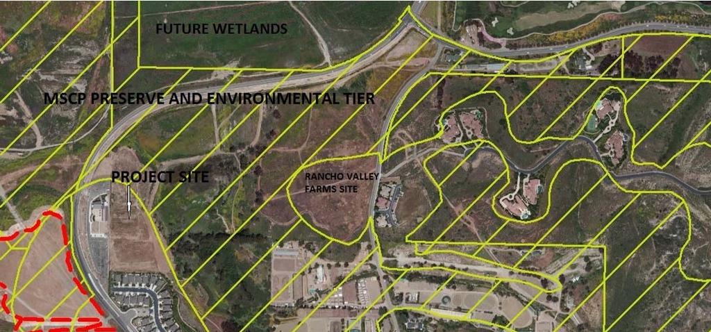
1 Agenda Item 1.a.i. April 4, 2014 TO: FROM: SUBJECT: CAC Project Review Committee and JPA staff St. John Garabed Church Project Comments on Draft EIR PRC RECOMMENDATION: Request that JPA send Draft EIR comment letter to include issues raised in this report and other comments determined appropriate by CAC. SITUATION: A. Background The St. John Garabed Church project (project) is proposed on a 13.4-acre site on El Camino Real approximately ½ mile east of Interstate 5 within the San Dieguito River Park s Focused Planning Area (FPA) (Landscape Unit B) adjacent to Gonzales Canyon and the San Dieguito lagoon wetland restoration project (Attachments 1 and 2). The site is directly behind (east of) the recently-built Formosan Church and just north of the Stallions Crossing residential development. The project consists of a 350-seat church and three additional buildings totaling 51,680 square feet on a mesa overlooking the Gonzales Canyon open space corridor that connects to the San Dieguito Lagoon. A Draft EIR for the project has been circulated for public review and comments on the EIR are due by April 15, The project and EIR will be considered by the JPA Board at their April 18th meeting, although an EIR comment letter will be submitted to the City by JPA staff by the public review deadline. A church is an allowed use in the project site zone (AR-1-1) with a Conditional Use Permit (CUP). The site is in Subarea II of the North City Future Urbanizing Area, and requires a coastal permit from the Coastal Commission because Subarea II does not have a subarea plan and is considered a deferral area. The church structure is 93 feet in height including a 50-foot tall dome. This is equivalent to a 9-story structure, much taller than the surrounding development (the tallest approved structure in the area is the Formosan church next door at 45 feet). The church itself represents approximately 11 percent of the total building area. The other three structures consist of an 18,090 sf multi-purpose hall (2 story, 40 feet tall), an 11,010 sf education facility with 10 classrooms (2 story, less than 30 feet), and a 13,840 sf youth recreational facility (less than 30 feet). : 3
2 Agenda Item 1.a.i. April 4, 2014 B. Issues The PRC has spent considerable effort reviewing this project beginning in June 2011 when the JPA first became aware of the project. The project has been before the PRC on several occasions where PRC members and project representatives conducted site visits and reviewed and discussed the project design. In addition, three comment letters submitted between 2011 and 2013 raised concerns about the project design (Attachment 3). Despite requests from JPA staff and the PRC to modify the project s design to address issues raised (see below) the project has proceeded largely as originally proposed. The project site is at the western edge of the San Dieguito River Park Concept Plan s Landscape Unit B (Gonzales and La Zanja Canyons) near the San Dieguito lagoon wetland restoration project and includes land in Gonzales Canyon. Much of the site is within the City s Multiple Habitat Preserve Area (MHPA) because it is a wildlife corridor. The special design considerations in the SDRP Concept Plan most relevant to this site include: Future development proposals within this area shall include the dedication of open space corridors consistent with the intent of the SDRP. These open space corridors, which would be provided within La Zanja and Gonzales Canyons, should be of adequate size to accommodate both wildlife and human movement. Adequate measures should be taken by the development to ensure the preservation of existing sensitive habitat or where necessary, native habitat within the areas should be restored in order to ensure functional open space linkages between the San Dieguito River Park and open space areas to the south. Development on the adjacent ridges should be set back from the top of slope in order to reduce its visibility from the FPA, as well as to provide for an upland transition area that will serve to buffer the development from the adjoining natural habitat. Future development within Gonzales Canyon shall conform to the Implementing Principles for Development adjacent to Significant Natural Areas (4.10a-4/10o), as outlined in the North City FUA Framework Plan. The Environmental Tier in the NCFUA Framework Plan is an open space system similar in both intent and area to the MSCP Preserve area. The relevant Framework Plan implementing principles apply to development adjacent to significant natural areas such as the environmental tier and the San Dieguito River Valley FPA and include: 4.10i Development adjacent to ridges and bluffs shall minimize visual impacts to these topographic features through setbacks and landscaping, especially near major canyons or valleys. : 4
3 Agenda Item 1.a.i. April 4, l Structures located within the view of the park (SDRP), if within 200 feet vertically and 50 feet horizontally of a ridgeline, shall be set back and be low in profile so as not to be visually prominent from the future park. 4.10n All exterior lighting shall be low-sodium type with horizontal cut-off and shall be shielded downward such that the light would not be visible to the adjacent properties and the proposed park. 5.2d Because of the importance of continuous open space that provides for plant and animal movement, portions of the environmental tier may not be eliminated based solely on an absence of sensitive resources within the area designated. 5.4c Wildlife corridors shall be the width required to provide for a continuous space in which animals can move without fear, undisturbed by lighting, noise and intense human activity. The issues raised multiple times by the PRC regarding the project s impacts are: Impacts to MSCP Gonzales Canyon Wildlife Corridor: The proposed development is proposed on a mesa top above the Gonzales Canyon drainage floodplain and includes a mitigation plan to preserve and restore the habitat area (drainage) that leads to the new wildlife culvert undercrossing at El Camino Real. The proposed mitigation will improve and restore the native vegetation including riparian wetlands along the drainage (Attachment 4). However, the project buildings are proposed on the edge of the mesa top directly adjacent to this wildlife corridor. The project sits at the edge of the existing slope (i.e., the mesa) above the Gonzales Canyon open space and the closest structure would sit approximately 20 feet from the slope. Attachments 1 and 5 illustrate the project s location in context with the surrounding uses and future projects. Along with the drainage area itself, the northern portion of the mesa is part of the MSCP Preserve Area and identified as an Environmental Tier in the NCFUA Framework Plan (see below). The adjacent open space (recently dedicated to the City as MSCP Preserve as a condition of the Rancho Valley Farms project) includes wetlands and a pond that attracts wildlife as they pass through Gonzales Canyon and into the lagoon area. The proposed development will encroach into the MSCP Preserve area, which will require an MSCP boundary adjustment to accommodate the development. Because a majority of the project site is within the MSCP Preserve area (82% of the project site the majority in the floodplain below the mesa), a 25% development encroachment into the Preserve area is allowed per the MSCP. This encroachment allowance provides the project with the ability to develop 3.35 acres of the Preserve (in addition to area outside the MSCP Preserve). However, the project is also proposing to encroach an additional 0.88 acre into the Preserve for a total of 4.23 acres of development within the MSCP Preserve. This additional encroachment does not seem justified nor is it sensitive to the value of this area as a wildlife movement corridor and as a visually important component of the river valley landscape. As an alternative, the church and associated buildings could : 5
4 Agenda Item 1.a.i. April 4, 2014 be reduced in size and moved back from the mesa edge to reduce the impact to the corridor. Statements made in the Draft EIR regarding the necessity to build at the magnitude proposed are unsupported. The Gonzales Canyon wildlife corridor identified in the City s MSCP and the SDRP Concept Plan comes out of Gonzales Canyon from the southeast and connects to the broad floodplain of the San Dieguito River Valley. Evidence of high wildlife use of this corridor has been collected from recent camera trap images (on the adjacent property) by the San Dieguito River Valley Conservancy. Mammals including bobcat, coyote, and mule deer, as well as numerous smaller species, use this corridor. The importance and high use of this corridor is not adequately documented in the Draft EIR. The proposed project site plan includes a 93-foot-tall church located 20 feet from the edge of the mesa overlooking the MSCP wildlife corridor. The function and use of this wildlife corridor has become more important as the lagoon has been restored, as open space has been set aside and restored to native habitat as a result of adjacent projects (Rancho Valley Farms and Formosan Church), and as an improved wildlife undercrossing was constructed under El Camino Real as a safe crossing of this busy roadway. The proposed development should be designed to minimize its impact on the function of the wildlife corridor by locating tall buildings further from the mesa edge. Currently as designed the project does not provide a buffer between development and wildlife habitat and will introduce light, noise, and human activity, potentially intimidating the wildlife moving through the area. The project should set the buildings further back from the mesa edge to provide the necessary buffer from the open space as intended by the MSCP and Environmental Tier. The proposed project entrance off El Camino Real would also be located within the MSCP Preserve approximately 400 feet north of the Formosan Church entrance driveway. This access will isolate the habitat mitigation site that was required for the adjacent church and will shine automobile lights, and add noise directly adjacent to the wildlife corridor particularly at night when animals move through the area. Although lights and noise from El Camino Real pass by the open space, the access road will bring cars directly into the Preserve area. The Draft EIR does not adequately address this issue. Human activity areas (plazas and parking areas) are also proposed directly adjacent to the open space (at the edge of the mesa top overlooking the corridor). Exterior lights would exist within the plazas, parking areas, and access road directly adjacent to the native habitat and wildlife corridor. These potential edge effects are not adequately analyzed in the DEIR and the conclusion that impacts would be insignificant is not supported with substantial evidence. : 6
5 Agenda Item 1.a.i. April 4, 2014 The subject project would consist of four large high-activity buildings with a circulation system adjacent to the open space. The buildings range from 28 to 40 feet in height and the church structure, closest to the wildlife corridor, would be 93 feet in height (equivalent to a 9-story structure). Human encroachment including lights and noise from human activity and vehicles will impact the corridor s function unless an adequate buffer is provided. Draft EIR Analysis The Draft EIR does not sufficiently recognize the importance of the wildlife corridor or the diversity of species that currently move through the area and claims the project would have a beneficial impact on the habitat linkage within Gonzales Canyon while dismissing its impacts. It states that the habitat on the site currently provides relatively few resources for wildlife due to the lack of cover and structural diversity (page ). This is contrary to recent evidence of a heavily used corridor. Although the proposed mitigation plan would improve the habitat, the new human use adjacent to the corridor would impact its function. The proposed buildings could be reduced in size and moved further away from the mesa edge to provide a buffer. The EIR does not adequately explain why the project couldn t be built on a smaller footprint to provide an adequate buffer. The EIR does not acknowledge that native habitat on the project site in the wildlife corridor was recently mowed and disked without authorization and claims that Gonzales Canyon has currently no cover or foraging opportunities for wildlife. The impact took place in May or June of 2013 under the current ownership where sensitive native habitat was destroyed during the nesting season. The EIR does not acknowledge the impact of the project on the corridor itself and only promotes the benefits of the mitigation plan (page and 73). The access entrance drive is only discussed in the context of a location further into the MHPA Preserve that had been previously considered by the project proponent and subsequently rejected. The EIR dismisses impacts of the access road by promoting it as better than what had been considered previously (page ). CEQA requires that the analysis be based on the impacts of a proposed project on the existing condition and setting, not compared to an earlier design. Typically, the existing condition is defined as when the notice of preparation is published (in this case, July 2013). The most sensitive portion of the project site, where mature vegetation offered cover for wildlife species, was mowed and disked in May or June 2013, just prior to the release of the NOP. Furthermore, the project s mitigation is partially on this area that until recently was native habitat. The EIR concludes that the area in the lower portion within Gonzales Canyon is unaffected by the take and management will be unaffected (page ) with no substantive evidence or analysis to support such a conclusion. The EIR states that the area is periodically in crops or is devoid of vegetation and disked (page ). However, based on our observations most of the project site had not been : 7
6 Agenda Item 1.a.i. April 4, 2014 farmed for several years and mature native vegetative cover did exist in the bottom portion of the corridor closest to the wildlife undercrossing before it was recently mowed and disked (no crops were planted). The biology analysis does not support the conclusions made. For example, a statement is made that the project is separated from the Gonzales Canyon by a foot slope which will protect wildlife as they move through the canyon, yet it does not explain how that slope would protect wildlife next to a 93-foot tall structure at the edge of that slope and next to the proposed project access road cut into the slope, nor whether the project s proximity and use would impact wildlife moving through the corridor. The EIR also states that the project would not compromise the preserve efficiency or effectiveness and no impacts will occur to the habitat linkage because the project would be confined to the mesa on existing disturbed land. Edge effects to the wildlife corridor are dismissed and conclusions are not substantiated with evidence. The EIR states that the project mitigation to restore/enhance 1.76 acres of onsite habitat will vastly improve the function of the canyon for wildlife movement (page ). While there is no question that restoration improves habitat value for wildlife, the corridor had been heavily used by wildlife for years (including mule deer, bobcat, and coyote). It is likely that wildlife use has declined since the vegetation was mowed and disked in The EIR does not adequately analyze the impact of the project design or the loss of a buffer from the corridor, and primarily just promotes the benefits of the mitigation plan. The supposed net benefit of the mitigation plan to the wildlife corridor is unsubstantiated (considering the adjacency edge effects of the project) and the EIR analysis does not adequately support the conclusion made. The EIR makes inaccurate statements and cites mitigation measures that don t exist. For example, only one biology mitigation measure exists (BIO-1) yet the analysis states that measures BIO-2 and BIO-3 would mitigate impact from invasive species and impacts to the MSCP, yet these measures do not exist. The EIR never explains nor substantiates why a smaller project footprint wouldn t meet the goals and objectives of the project. Impacts to the Visual Open Space Character of the River Valley: The EIR states that according to the City code, deviations from the AR-1-1 zone base maximum height of 30 feet are allowed in circumstances where side yard setbacks are increased (as proposed for this project). However, the community plan and SDRP Concept Plan policies regarding protection of visual quality and open space must also be considered. Height deviations are discretionary and should be considered in the context of the goals and policies of the SDRP Concept Plan. Furthermore, additional deviations for side and rear yard setbacks are also being requested by the project proponent for the : 8
7 Agenda Item 1.a.i. April 4, 2014 education and youth center buildings. Given the constraints on the project site, the sensitivity of the surrounding area both biologically and visually, the site s prominent location within the San Dieguito River Valley, the visibility of the site from public views (trails and roads), and the goals and policies of the FUA Framework Plan and SDRP Concept Plan that protect open space, valleys, and wildlife, the project appears to be overbuilt for the site. The building location and scale is inconsistent with the Concept Plan design guidelines and the NCFUA Framework Plan. The Framework Plan policies and implementing principles include an open space plan (Environmental Tier) to protect the river valley and view corridors through height reductions and setbacks. The 93-foot high sanctuary and 40-foot high hall structure technically comply with the City building height codes because the project provides greater than the minimum setbacks from property lines. However, the project is inconsistent with the land use plans and policies for this area that were written to protect views into and from the San Dieguito River Valley. Policies in the NCFUA Framework Plan and SDRP Concept Plan require developments to be low lying in profile and not visually prominent in this part of the valley. The EIR states that the church would be visually prominent from low-laying areas of the western side of Gonzales Canyon, but that the structures will be screened with landscaping that will include native shrubs and groundcover, grasses, lawn, etc. and the stone finish or plaster finish with earth-tone colors would tend to recede into the background landscape with distance and that the church has been set back from the property line to the extent possible. The proposed landscaping cannot screen a 93-foot tall structure that would greatly exceed the height of most plantings and surrounding buildings and loom over the adjacent wildlife corridor. Furthermore, reasons given that the square footage is the minimum necessary to meet the goals of the project lack substantial evidence to justify the need to impact the river valley s visual quality to such an extent. Recently-approved surrounding projects (Formosan Church and Rancho Valley Farms) have adhered to the MSCP boundaries and goals and policies of the SDRP Concept Plan and environmental tier of the Framework Plan. The Formosan Church will have a maximum height of 45 feet (currently only a portion of that project is built). The proposed buildings will dominate public views from the San Dieguito River Valley, extend into the MSCP Preserve and environmental tier, and will eliminate any buffer to the Preserve, and will not be set back sufficiently to minimize impacts to the FPA. EIR Analysis The Draft EIR concludes that based on the visual analysis presented and based on the discussion of scenic views/vistas, the project would not be located in a highly visible area (emphasis added) and would not contrast visually with the overall character of the : 9
8 Agenda Item 1.a.i. April 4, 2014 surrounding area (page ). These conclusions are false and appear to be based on poor-quality visual simulations that show the proposed structures faded in the distance. Substantial evidence is lacking to support conclusions reached in the EIR. At the same time, the EIR also states that the project would have a significant and unavoidable impact on neighborhood character because the church dome is 50 feet higher than the adjacent church and 70 feet higher than the adjacent residential development (page ). Confusing statements are made to support this conclusion: though portions of the proposed church will be visible from adjacent properties, with landscaping and natural building materials and colors, the project would not be located in a highly visible area and contrast with the overall character of the area. And because the proposed 93-foot tall dome would be taller than surrounding development and would result in visible contrast impacts are considered significant and unavoidable. It appears that impacts to surrounding private developments were considered to be a significant impact, yet impacts to surrounding public views into and from the river valley were not. Project Alternatives Analysis CEQA requires that an EIR provide feasible project alternatives capable of avoiding or substantially lessening any significant effects of the project while feasibly attaining most of the project objectives (Section ). The subject EIR dismisses the Reduced Project Alternative without defining or explaining what a reduced project would look like, and only states that it would not meet the needs of the Armenian Church community (currently provided on 30 th Street in North Park, San Diego) without substantiating the conclusion with evidence. An alternative that meets the MSCP encroachment allowance of 25% should be analyzed as a viable alternative.. A project alternative that moves the structures further back from the mesa away from the wildlife corridor would provide a buffer from Gonzales Canyon thereby reducing significant impacts to the MSCP Preserve. The EIR does not offer or consider such an alternative. Trail Connection For several years both City and JPA staff have been planning a trail route through Gonzales Canyon to eventually connect to the Coast to Crest Trail. The trail exists through Pacific Highlands Ranch to Old El Camino Real. The PRC and JPA have had multiple discussions with the subject project owner about the need for a trail easement through a short length of their property to connect the trail from the adjacent Rancho Valley Farms project to El Camino Real. The property owner has consistently stated that they do not object to providing a trail easement. Yet, no mention is made in the Draft EIR about trail connections from Gonzales Canyon to El Camino Real and the Coast to Crest Trail. The existing trail currently terminates at Old El Camino Real, but will soon continue west on the Rancho Valley Farms project currently under construction (required as a project condition). The trail route will then continue further west toward El Camino Real along : 10
9 Agenda Item 1.a.i. April 4, 2014 the edge of the MSCP Preserve area (dedicated as part of the Rancho Valley Farms project), although the exact alignment hasn t been determined. Various trail routes have been explored by City and JPA staff. To connect to El Camino Real the trail must cross a short segment of the St. John Garabed Church property. JPA staff was hopeful that the new El Camino Real culvert undercrossing could be used to route the trail under the road. However, the head room in the new culvert is low (particularly for horses) and a large quantity of sediment exists on the floor of the culvert. Furthermore, the mitigation plan proposed by the Garabed Church project will restore wetlands leading into the culvert thereby eliminating space needed for a trail. However, other trail route alternatives exist. Recent field reconnaissance done jointly by JPA and City staff confirmed that a workable trail route through the open space on both parcels could connect to the existing D.G. path along the east side of El Camino Real that leads to the intersection at San Dieguito Road. At that point the trail route would continue to the Coast to Crest Trail, which is being designed in coordination with the City s El Camino Real bridge replacement project and the SANDAG/JPA wetland restoration project (called W19 ) on the west side of El Camino Real. According to City Park and Recreation planning staff, a proposed condition on the subject project requires the property owner to grant a recreation easement for trail purposes but that the exact location of the easement will be determined at a later date and the property owner will not be responsible for the cost associated with granting, constructing or maintenance of the trail. It is JPA staff s understanding that the open space on the subject church project will be preserved through a conservation easement although no specifics have been provided. The EIR should acknowledge and discuss the future trail even if an exact alignment hasn t been determined. The concern is still that the EIR does not acknowledge the trail use on the subject property. Potential Inconsistency with CUP Finding A place of worship (i.e., church) in an agricultural zone is allowed with a Conditional Use Permit if certain required findings can be made. One of those findings is that the development will not adversely affect the applicable land use plan (Section of City Municipal Code). The land use plan for this area is the NCFUA Framework Plan. For the reasons described above regarding the visual impacts of the project on the San Dieguito River Valley and Gonzales Canyon open space under the Framework Plan and SDRP Concept Plan, a finding that the project would not adversely affect the land use plan would be difficult to make. In addition, the EIR concludes that the project would create significant visual impacts that couldn t be mitigated. The project design should be reduced in bulk and scale to provide a wider setback from the MSCP Preserve and reduce its visibility in such a visually significant area. Attachments: 1. Project Vicinity : 11
10 Agenda Item 1.a.i. April 4, Site Plan 3. Previous letters from JPA staff 4. Restoration Plan 5. MSCP Preserve and NCFUA Environmental Tier : 12
 GONZALES CANYON DUST DEVIL NATURE TRAIL ATTACHMENT")
11 Wildlife Undercrossing MSCP PRESERVE PROJECT SITE RANCHO VALLEY FARMS (UNDER CONSTRUCTION) GONZALES CANYON DUST DEVIL NATURE TRAIL ATTACHMENT 1 13

12 Z:\Projects\j686501\MAPDOC\MAPS\EIR FIGURE 3-1 Site Plan 6865 ST. JOHN GARABED CHURCH PROJECT EIR 14 ATTACHMENT 2
13 November 13, 2012 Mr. John Fisher City of San Diego Development Services Dept First Avenue, MS501 San Diego, CA Subject: Comments on Proposed St. John Garabed Church; Project # Dear John: After reviewing the proposed plans for this project as recently resubmitted in September, it appears that few of the issues expressed in our previous comment letter (10/26/11) have been addressed. As previously stated, this project is located in the San Dieguito River Park s FPA on a prominent mesa in the San Dieguito River Valley and thus its location and design is of importance to the JPA. While we appreciate the project s representatives presenting to the JPA s Project Review Committee over the past year, they have not addressed our issues and their project design has changed only minimally. Therefore, the comments stated in our 10/26/11 letter still stand. In summary, the issues that remain of primary concern to the JPA are: The mass and scale of the project is in direct conflict with the San Dieguito River Park Concept Plan and with community planning policies as cited by City staff in their project assessments. The project is not solely a church use, but additional uses housed in a complex of large structures totaling 51,680 square feet that is out-of-scale with the surrounding area representing an over-intensification of use on the property. The proposed MHPA boundary adjustment is excessive since over half of the project encroaches into the existing MHPA. The MHPA was designed to protect the sensitive nature of this area above the Gonzales Canyon floodplain as it flows into the San Dieguito River Valley. The proposed boundary adjustment intrudes into the approved open space preserve on the adjacent Pardee project and isolates an existing mitigation site on the Formosan Church property. The result would create a habitat island next to El Camino Real, not the intension of the MSCP. The proposal would compromise the MHPA in this area. It appears that the church could be accommodated within the existing MHPA boundary without harming the integrity of the MSCP and adjacent wetlands. However, as proposed the project is overbuilt for the site. Adjacent recently- 15
14 Mr. Fisher Page 2 built or approved projects do comply with the MSCP (Pardee s Rancho Valley Farms and the Formosan Church) and this project should as well. Even with a significant encroachment into the MHPA, the project proposes yet more encroachments into the required setbacks. What are the hardships on this property that warrant the zoning code deviations? It does not appear that findings for a deviation could be made. Again, the proposed project is not limited to a church sanctuary but includes a school, hall, and youth center that together represent an intensity of use incompatible with the surrounding open space, sensitive adjacent MHPA land, and the goal to protect the San Dieguito River Valley. The sanctuary represents only 17% of the total square feet. No mitigation is proposed to offset impacts associated with MHPA encroachment and adjacency to a wildlife corridor. This corridor has been recently enhanced by a new wildlife culvert to better facilitate wildlife movement under El Camino Real. What impacts will this project have on the quality of the wildlife corridor from lights, human activity (particularly at night), and noise? Views into the project from surrounding public areas would be significant, dramatically changing the open visually appealing landscape of the river valley. The proposed 51,680 square foot complex of structures would unnecessarily obstruct the views in the river valley. The excessive height of these structures (32 to 40 feet) dwarfs the neighboring Formosan Church and intrudes into the viewshed. These buildings would be seen from several public roads, trails, and a San Dieguito River Park public educational facility to be constructed in 2013 across the valley to the northwest of the project site (open air trailside classroom). The fact that the existing zone allows a maximum height over 30 feet on this site under certain conditions is not the only factor to consider. Policies included in the NCFUA plan, coastal plan, San Dieguito River Park Concept Plan, MSCP, and CUP findings hold equal weight and must be considered. Combined with the newly constructed Formosan church project and the potential for development on the private parcel behind the subject site, cumulative visual impacts would add substantial development in the river valley and adjacent to a wildlife corridor. The entire east side of El Camino Real will be developed with an intensive collection of large buildings and active uses. This would cause cumulatively significant visual and biological impacts that must be addressed. As noted in our previous letter, the subject property abuts an approved trail easement on the Pardee Rancho Valley Farms site. This trail link from Gonzales Canyon is planned to eventually connect to the Coast to Crest Trail. The subject property lies between the Pardee trail easement and El Camino Real and must be crossed in order to reach the new culvert under El Camino Real (proposed as a trail undercrossing). We understand that the applicant is not opposed to a trail on their property but that trail planning and permitting is not part of their project. We would like their project to include a possible easement for the trail although we realize that permit approvals have not yet been obtained for a trail. We would appreciate the opportunity to work with City Parks and Recreation staff on a trail easement proposal. 16
15 Mr. Fisher Page 3 We are disappointed that the most of the issues expressed in our previous letter (now over a year ago) have yet to be addressed by the applicant s project. We appreciate City staff s consideration of the JPA s concerns. Sincerely, Shawna C. Anderson, AICP Environmental Planner Cc: Bernie Turgeon, Development Services Carmel Valley Community Planning Board Marcela Escobar-Eck, Atlantis Group LLC 17
16 18
17 19
18 20
19 21
20 22
21 23
22 WILDLIF S A N D O U I T G I E E MOVEME NT R R I V E Wildlife Crossing at El Camino Real Restoration Site See Figure 4 for Restoration Plan Rancho Valley Farms (houses under construction) Project Boundary SanGIS MHPA Boundary Vegetation dcss - disturbed Diegan Coastal Sage Scrub CSS - Diegan Coastal Sage Scrub Document Path: Z:\Projects\j686501\MAPDOC\MAPS\CMP Figs\CMP Fig3-Site.mxd DH - Disturbed Habitat MFS - Mulefat Scrub SWS - Southern Willow Scrub Project Site TS - Tamarisk Scrub Formosan Church Jurisdictional Delineation ACOE/CDFW/CCC/City CDFW/CCC/City Wildlife Movement MSCP Preserve Boundary Restoration Proposed for Enhancement (0.19 acre) Proposed Wetland Creation (1.64 acre) Proposed Wetland Creation (Taylor Morrison) Upland/Wetland Transitional Buffer restoration (0.12 acres) Feet FIGURE 3 SOURCE: SanGIS 2010, Bing Maps 6865 JUNE 2013 Project Site Map Conceptual Restoration Plan for the St. John Garabed Church Project 24 ATTACHMENT 4
23 25
AGENDA SAN DIEGUITO RIVER VALLEY REGIONAL OPEN SPACE PARK CITIZENS ADVISORY COMMITTEE. 10:30 a.m. to 12:15 p.m. Friday, July 12, 2013
 AGENDA SAN DIEGUITO RIVER VALLEY REGIONAL OPEN SPACE PARK CITIZENS ADVISORY COMMITTEE 10:30 a.m. to 12:15 p.m. Friday, July 12, 2013 NEW LOCATION San Rafael Parish 17252 Bernardo Center Drive, Rancho Bernardo
Nob Hill Pipeline Improvements Project EIR
 Section 3.1 Aesthetics This section addresses the visual aspects that may affect the views experienced by the public, including the potential to impact the existing character of each area that comprises
CHAPTER 5.0 ENVIRONMENTAL IMPACT ANALYSIS
 CHAPTER 5.0 ENVIRONMENTAL IMPACT ANALYSIS Chapter 5 contains an analysis of the potential environmental impacts that may occur through implementation of the proposed project, including anticipated future
3.10 LAND USE SETTING PROJECT SITE EXISTING LAND USE DESIGNATIONS AND ZONING. General Plan Land Use Designations.
 This section of the Draft EIR addresses the existing land uses on and adjacent to the project site and discusses the potential impacts of the proposed project on existing land uses. Key issues addressed
AGENDA SAN DIEGUITO RIVER VALLEY REGIONAL OPEN SPACE PARK CITIZENS ADVISORY COMMITTEE. 10:30 a.m. to 12:15 p.m. Friday, June 1, 2007
 AGENDA SAN DIEGUITO RIVER VALLEY REGIONAL OPEN SPACE PARK CITIZENS ADVISORY COMMITTEE 10:30 a.m. to 12:15 p.m. Friday, June 1, 2007 Hope United Methodist Church, Covenant Hall 16550 Bernardo Heights Parkway
SUBJECT: Comments on Del Mar Fairgrounds Master Plan Draft Environmental Impact Report
 Dustin Fuller, Sr. Environmental Planner 22 nd District Agricultural Association Del Mar Fairgrounds 2260 Jimmy Durante Boulevard Del Mar, CA 92014-2216 February 5, 2010 SUBJECT: Comments on Del Mar Fairgrounds
File No (Continued)
") (Continued) Request for: (1) a Site Plan Review; (2) a Variance (to build on a significant ridgeline); (3) an Oak Tree Permit (to encroach into the protected zone of 25 oak trees and for potential thinning
(Continued) Request for: (1) a Site Plan Review; (2) a Variance (to build on a significant ridgeline); (3) an Oak Tree Permit (to encroach into the protected zone of 25 oak trees and for potential thinning
GENERAL PLAN CONSISTENCY ANALYSIS
 GENERAL PLAN CONSISTENCY ANALYSIS Prepared by Planning Staff 10/28/2013 APPLICABLE GOALS, POLICIES AND PROGRAMS FROM the LAND USE CHAPTER Goal LU-1 Policy LU-1.1 Policy LU-1.2 Goal LU-2 Protect the character
APPENDIX A 6 CONCEPTUAL PRELIMINARY PLAN GUIDE AND CHECKLIST FOR MAJOR SUBDIVISIONS CARRBORO DEVELOPMENT GUIDE APPENDIX A
 6 CONCEPTUAL PRELIMINARY PLAN GUIDE AND CHECKLIST FOR MAJOR SUBDIVISIONS Conceptual Preliminary Guide/Checklist for Major Subdivisions Page 1 FORM: REVIEW DATE: CONCEPTUAL PLAN REVIEW 2000 REVIEWED BY:
Public Review Draft Oceanside Subarea Habitat Conservation Plan/ Natural Communities Conservation Plan
 Oceanside Subarea Habitat Conservation Plan/ Natural Communities Conservation Plan Prepared for City of Oceanside Planning Department 300 N. Coast Highway Oceanside, CA 92054 Prepared by Ogden Environmental
IV.B. VISUAL RESOURCES
 IV.B. VISUAL RESOURCES ENVIRONMENTAL SETTING Existing Visual Character Project Site The project site is located at 17331-17333 Tramonto Drive in the Pacific Palisades community of the City of Los Angeles
3. VISION AND GOALS. Vision Statement. Goals, Objectives and Policies
 Vision Statement Queen Creek s interconnected network of parks, trails, open spaces and recreation opportunities provide safe and diverse activities and programs that sustain its unique, small town, equestrian
Planning Commission Staff Report June 5, 2008
 Owner/Applicant Taylor Village Sacramento Investments Partners, LP c/o Kim Whitney 1792 Tribute Road #270 Sacramento, CA 95815 Staff Recommendation Planning Commission Staff Report Project: File: Request:
City of Lafayette Study Session Staff Report Design Review Commission
 ++ City of Lafayette Study Session Staff Report Design Review Commission Meeting Date: January 08, 2018 Staff: Subject: Chris Juram, Planning Technician SS12-17 Miramar Homebuilders, R-20 Zoning: Request
4.1 LAND USE AND HOUSING
 4.1 This section provides a project-level analysis of potential impacts to land use, Shorelines of the State (shorelines), and housing. The study area for the land use and housing analysis in the Final
City of Sun Prairie Wetland Buffer Reduction Request
 City of Sun Prairie Wetland Buffer Reduction Request Westside Development Area January 9, 2017 Prepared by: City of Sun Prairie 300 E. Main Street Sun Prairie, WI 53590 BACKGROUND The City of Sun Prairie
City of Lafayette Study Session Staff Report Design Review Commission
 City of Lafayette Study Session Staff Report Design Review Commission Meeting Date: April 24, 2017 Staff: Payal Bhagat, Senior Planner Subject: HDP18-15 & HDP31-15 Ramesh Patel & Melcor Development (Owners),
-MENDOCINO COUNTY PLANNING AND BUILDING SERVICES- DIVISION II OF TITLE 20--COASTAL ZONING CODE
 CHAPTER 20.504 VISUAL RESOURCE AND SPECIAL TREATMENT AREAS Sec. 20.504.005 Applicability. Sec. 20.504.010 Purpose. Sec. 20.504.015 Highly Scenic Areas. Sec. 20.504.020 Special Communities and Neighborhoods.
CHAPTER 10 AESTHETICS
 CHAPTER 10 AESTHETICS CHAPTER 10 AESTHETICS This section identifies and evaluates key visual resources in the project area to determine the degree of visual impact that would be attributable to the project.
The impacts examined herein take into account two attributes of aesthetic values:
 IV. ENVIRONMENTAL IMPACT ANALYSIS This section addresses the potential impacts to views and aesthetics as a result of the proposed Project at the Project Site and the development scenarios analyzed for
Mitchell Ranch South MPUD Application for Master Planned Unit Development Approval Project Narrative. Introduction
 Mitchell Ranch South MPUD Application for Master Planned Unit Development Approval Project Narrative Introduction Mitchell Ranch South is a proposed single family (detached) residential development on
PLANNING COMMISSION AGENDA REPORT SEPTEMBER 1, 2016
 PLANNING COMMISSION AGENDA REPORT SEPTEMBER 1, 2016 TO: Members of the Planning Commission FROM: Michael Klein, Planner FILE NO.: 150000780 PROPOSAL: APPLICANT: RECOMMENDATION: A request for a Site Plan
2.0 AREA PLANS. Lakeside Business District. Lakeside Business District Land Use Categories:
 Lakeside Business District Lakeside Business District Land Use Categories: Campus Commercial Campus Commercial means a mixture of uses which includes corporate offices, office parks, hotels, commercial,
5.1 AESTHETICS AND VISUAL RESOURCES Physical Setting
 5.1 AESTHETICS AND VISUAL RESOURCES 5.1.1 Physical Setting Aesthetic values are an important aspect in establishing the identity, sense of place, and quality of life in a community. Natural features in
HISTORIC LANDMARK COMMISSION STAFF REPORT
 HISTORIC LANDMARK COMMISSION STAFF REPORT Park Strip Raised Planter Boxes Minor Alteration PLNHLC2014-00603 163 D Street Meeting Date: November 6, 2014 Planning Division Department of Community and Economic
CITY OF LAGUNA BEACH COMMUNITY DEVELOPMENT DEPARTMENT STAFF REPORT DESIGN REVIEW BOARD IBOARD OF ADJUSTMENT Coast Highway APN
 CITY OF LAGUNA BEACH COMMUNITY DEVELOPMENT DEPARTMENT STAFF REPORT HEARING DATE: October 13,2011 TO: DESIGN REVIEW BOARD IBOARD OF ADJUSTMENT CASE: Variance 7717 Design Review 11-163 Coastal Development
Notice of Preparation of an Environmental Impact Report and Scoping Meeting for the Canyon Lane Roadway Improvements Development Project
 of an Environmental Impact Report and Scoping Meeting for the As the Lead Agency, the County of San Mateo (County) will prepare an Environmental Impact Report (EIR) for the (project), and would like your
PLANNING COMMISSION. Submitted
 PLANNING COMMISSION City Hall 1275 Main Street El Centro, CA 92243 Submitted PLANNING COMMISSION ACTION ITEM (1844) Meeting: 05/10/16 12:00 AM Department: Community Development Category: Public Hearing
DRAFT MAP AMENDMENT FLU 04-4
 DRAFT MAP AMENDMENT FLU 04-4 SW 24 TH AVENUE ROADWAY CORRIDOR The University of Florida participates with the Metropolitan Transportation Planning Organization (MTPO) in its responsibilities for the continuing,
PC RESOLUTION NO ARCHITECTURAL CONTROL (AC)
") PC RESOLUTION NO. 16-07-26- ARCHITECTURAL CONTROL (AC) 15-035 A RESOLUTION OF THE PLANNING COMMISSION OF THE CITY OF SAN JUAN CAPISTRANO, CALIFORNIA APPROVING ARCHITECTURAL CONTROL (AC) 15-035, INN AT
PC RESOLUTION NO. 16-07-26- ARCHITECTURAL CONTROL (AC) 15-035 A RESOLUTION OF THE PLANNING COMMISSION OF THE CITY OF SAN JUAN CAPISTRANO, CALIFORNIA APPROVING ARCHITECTURAL CONTROL (AC) 15-035, INN AT
UNIVERSITY OF CALIFORNIA, SAN DIEGO
 UNIVERSITY OF CALIFORNIA, SAN DIEGO BERKELEY DAVIS IRVINE LOS ANGELES MERCED RIVERSIDE SAN DIEGO SAN FRANCISCO SANTA BARBARA SANTA CRUZ CAMPUS PLANNING 9500 GILMAN DRIVE # 0074 TEL: (858) 534 6515 LA JOLLA,
SPECIFIC PLAN Requirements
 CITY OF LANCASTER PLANNING DEPARTMENT 44933 Fern Avenue, Lancaster, California 93534 (661) 723-6100 SPECIFIC PLAN Requirements Purpose The purpose of a specific plan is to provide for the logical development
Asbury Chapel Subdivision Sketch Plan
 Asbury Chapel Subdivision Sketch Plan PART 1: PROJECT SUMMARY Applicant: NVR Inc. Project Size: +/- 76.13 acres Parcel Numbers: 02101112,02116101,02116112, 02116113 Current Zoning: Transitional Residential
Gold Line Bus Rapid Transit Transit Oriented Development (BRTOD) Helmo Station Area Plan
 Helmo Station Area Plan") Appendix F Gold Line Bus Rapid Transit Transit Oriented Development (BRTOD) Helmo Station Area Plan Introduction and Purpose of the Plan The Gold Line Bus Rapid Transit facility is an eleven-mile dedicated
Appendix F Gold Line Bus Rapid Transit Transit Oriented Development (BRTOD) Helmo Station Area Plan Introduction and Purpose of the Plan The Gold Line Bus Rapid Transit facility is an eleven-mile dedicated
Chapter IV: Development Pattern
 Chapter IV: Development Pattern Introduction The 2002 Prince George s County Approved General Plan designates three growth policy tiers Developed, Developing, and Rural as well as three center designations
COMMUNITY DEVELOPMENT SERVICES PLANNING AND BUILDING DEPARTMENT PLACERVILLE OFFICE:
 COMMUNITY DEVELOPMENT SERVICES PLANNING AND BUILDING DEPARTMENT http://www.edcgov.us/devservices/ PLACERVILLE OFFICE: LAKE TAHOE OFFICE: 2850 Fair Lane Court, Placerville, CA 95667 924 B Emerald Bay Rd.
NOTICE OF PREPARATION
 NOTICE OF PREPARATION DATE: January 6, 2016 TO: LEAD AGENCY: Responsible Agencies, Organizations, and Interested Parties Contact: Tyler Barrington, Principal Planner Planning Department Community Development
DESIGN REVIEW COMMITTEE AGENDA ITEM
 DESIGN REVIEW COMMITTEE AGENDA ITEM AGENDA DATE: OCTOBER 3, 2012 TO: Chair Woollett and Members of the Design Review Committee THRU: FROM: SUBJECT: Leslie Aranda Roseberry, Planning Manager Daniel Ryan,
River Corridor Overlay Zone (RCOZ) Article 5
 Article 5") River Corridor Overlay Zone (RCOZ) Article 5 The site is in one of two designated districts. The first is the CBD (central business district) River District, which recognizes the urban character and unique
River Corridor Overlay Zone (RCOZ) Article 5 The site is in one of two designated districts. The first is the CBD (central business district) River District, which recognizes the urban character and unique
PLANNING COMMISSION AGENDA REPORT APRIL 7, 2016
 PLANNING COMMISSION AGENDA REPORT APRIL 7, 2016 TO: FROM: Members of the Planning Commission Talyn Mirzakhanian, Senior Planner FILE NO.: 160001710 PROPOSAL: APPLICANT: RECOMMENDATION: A request for a
Planning & Zoning Commission Staff Report
 Planning & Zoning Commission Staff Report Meeting Date: May 26, 2015 Drafted by: Katherine Harrison-Rogers CASE # Z2886 PROJECT NAME: APPLICANT/ REPRESENTATIVE: Shawna Runyan PROPERTY OWNER: 1840 (previously
Chapter 5: Natural Resources and Environment
 NATURAL RESOURCES AND ENVIRONMENT 5-1 5 Chapter 5: Natural Resources and Environment BACKGROUND AND INTENT Urban expansion represents the greatest risk for the future degradation of existing natural areas,
DRAFT SCOPE FOR THE DRAFT ENVIRONMENTAL IMPACT STATEMENT FOR HUDSON HIGHLANDS RESERVE TOWN OF PHILIPSTOWN, NEW YORK June 5, 2018
 DRAFT SCOPE FOR THE DRAFT ENVIRONMENTAL IMPACT STATEMENT FOR HUDSON HIGHLANDS RESERVE TOWN OF PHILIPSTOWN, NEW YORK June 5, 2018 Project Name: Project Location SEQRA Classification of Project: Lead Agency:
5.1.1 The streetscape along US Highway 64 (Brevard Road); and, The built environment within new residential developments; and,
; and, The built environment within new residential developments; and,") Article 5. Landscaping 5.1 Purpose The Town of Laurel Park s landscape standards are designed to create a beautiful, aesthetically pleasing built environment that will complement and enhance community
Article 5. Landscaping 5.1 Purpose The Town of Laurel Park s landscape standards are designed to create a beautiful, aesthetically pleasing built environment that will complement and enhance community
DESIGN REVIEW COMMITTEE AGENDA ITEM
 DESIGN REVIEW COMMITTEE AGENDA ITEM AGENDA DATE: OCTOBER 17, 2012 TO: Chair Woollett and Members of the Design Review Committee THRU: FROM: SUBJECT: Leslie Aranda Roseberry, Planning Manager Daniel Ryan,
Watertown City Council
 City of Watertown Watertown City Council April 14 th, 2015 Agenda Item: City Comment on Sun Share CUP Application Request for Action: Motion to Approve City Comments regarding CUP Application Department:
New Student Housing Draft EIR Public Meeting
 New Student Housing Draft EIR Public Meeting May 8, 2017 Meeting Overview Purpose of Meeting Sophomore Success Project Objectives Alternatives Project Site/Design Overview Biological Resource Impacts/Mitigation
Habitat Connectivity and Wildlife Corridor Stakeholder Meeting
 Habitat Connectivity and Wildlife Corridor Stakeholder Meeting VENTURA COUNTY PLANNING DIVISION JUNE 8, 2017 Agenda Introductions, Meeting Goal, and Format January 2017 Board Action Current Project Phasing
County of San Diego Comprehensive General Plan Update and Draft EIR Response LOG No. 02-ZA-001; SCH NO
 Development Services Tel: 760.744.1050 1 Civic Center Drive Fax: 760.591.4135 San Marcos, CA 92069-2918 Web: www.san-marcos.net Mr. Devon Muto Department of Planning and Land Use 5201 Ruffin Road, Suite
Report to City Council
 Attachment 4 BUDGET OFFICER CITY ATTORNEY APPROVALS CITY MANAGER Report to City Council TO: FROM: Mayor and City Council John C. Terell, Community and Economic Development Director AGENDA DATE: June 24,
The West Vaughan Employment Area Secondary Plan Policies
 Part 2: The West Vaughan Employment Area Secondary Plan Policies 2.1 General Policies It is the policy of Council: 2.1.1. That the West Vaughan Employment Area (the WVEA), identified on Schedule 1, will
Dwelling Units Max 12 dwelling units per acre/min 8 dwelling units per acre. Development Mix 80% non residential/20% residential
 13. OSTEEN LOCAL PLAN Background: The Osteen Local Plan area is located in southwest Volusia County along the SR 415 corridor between Lemon Bluff Road and Acorn Lake Road and includes 3,990 acres. The
36.1. PURPOSE APPLICABILITY DESIGN REVIEW GUIDELINES
 CHAPTER 36: DESIGN STANDARDS 36.1. PURPOSE The purpose of this chapter is to ensure that projects are designed and constructed consistent with the Community Design Subelement of the Land Use Element and
RZC Public View Corridors and Gateways
 RZC 21.42 Public View Corridors and Gateways 21.42.010 Purpose 21.42.020 Scope and Authority 21.42.030 Administration 21.42.040 Gateways Design 21.42.050 Unidentified Public Views 21.42.060 Identification
Town of Portola Valley General Plan. Nathhorst Triangle Area Plan
 Town of Portola Valley General Plan Amended December 10, 1997 Table of Contents Introduction... 1 Planning Area... 1 Objectives... 2 Principles... 2 Standards... 4 Description... 4 Community Commercial...
Appendix G Response to Comments
 Appendix G Response to Comments This appendix contains the comments received during the public circulation and comment period (May 27, 2008 to July 11, 2008). The comments have been numbered (Comment Set
4.8 LAND USE AND PLANNING
 4.8 LAND USE AND PLANNING 4.8.1 INTRODUCTION This section describes existing and planned land uses at the Hayward campus and analyzes the impact of implementation of the proposed Master Plan on land uses
General Location Annex, Rezone & Preliminary Plat Lansdowne Addition, Unit Three
 NEWFOUNDLAND I-5 Agricultural District Subject Site SUNDANCE ANDERSON Single Family Residential CHRISTY PUD Agricultural District Highway Business General Location Annex, Rezone & Preliminary Plat Lansdowne
COMMUNITY DESIGN. GOAL: Create livable and attractive communities. Intent
 COMMUNITY DESIGN Intent An attractive, well-designed County will attract quality development, instill civic pride, improve the visual character of the community, and create a strong, positive image for
PC RESOLUTION NO
 PC RESOLUTION NO. 14-01-14-02 TENTATIVE TRACT MAP fttm) 17441. REZONE {RZ) 13-003, ARCHITECTURAL CONTROL (AC) 13-003, TREE REMOVAL PERMIT (TRP) 13-052. GRADING PLAN MODIFICATION (GPM) 13-002. CONDITIONAL
Venice Pumping Plant Dual Force Main Project Draft EIR
 City of Los Angeles 5.9 LAND USE PLANS 5.9.1 Environmental Setting Venice Pumping Plant Dual Force Main Project Draft EIR The Project lies within the bounds of Los Angeles County and the City of Los Angeles.
DEPARTURE FROM DESIGN STANDARDS DDS-586
 The Maryland-National Capital Park and Planning Commission Prince George s County Planning Department Development Review Division 301-952-3530 Note: Staff reports can be accessed at www.mncppc.org/pgco/planning/plan.htm.
Saturday, August 4, 2018 at 11:38:32 AM Pacific Daylight Time. Page 1 of 1. To the Sonoma City Council Members:
 Saturday, August 4, 2018 at 11:38:32 AM Pacific Daylight Time Subject: Broadway & MacArthur Project Date: Saturday, August 4, 2018 at 9:48:47 AM Pacific Daylight Time From: Diane Jacobson To: Madolyn AgrimonH,
Regulation Changes for Open Space and Similar Uses
 Regulation Changes for Open Space and Similar Uses What is the Project? This project is an analysis of the Zoning Ordinance relating to public lands and open space regulations. The proposed text amendments
CHAPTER 2 SUMMARY 1. PROJECT SUMMARY DATA
 CHAPTER 2 SUMMARY This is an Initial Study format used to determine, pursuant to CEQA Guidelines Section 15177, whether a project 1) is within the scope of a Master EIR (MEIR), 2) may result in additional
DATE: PLANNING COMMISSION MEETING OF APRIL 27, 2016 SUBJECT: REQUEST FOR THE REMOVAL OF FIVE HERITAGE TREES AT 95 MERCEDES LANE (APN )
") DATE: PLANNING COMMISSION MEETING OF APRIL 27, 2016 TO: FROM: THE PLANNING COMMISSION HALEIGH KING, ASSISTANT PLANNER SUBJECT: REQUEST FOR THE REMOVAL OF FIVE HERITAGE TREES AT 95 MERCEDES LANE (APN 070-230-150)
DATE: PLANNING COMMISSION MEETING OF APRIL 27, 2016 TO: FROM: THE PLANNING COMMISSION HALEIGH KING, ASSISTANT PLANNER SUBJECT: REQUEST FOR THE REMOVAL OF FIVE HERITAGE TREES AT 95 MERCEDES LANE (APN 070-230-150)
PART 1: PROJECT SUMMARY. Proposed Land Use: 120 single-family lots. The application is Attachment A. The site plan is Attachment B.
 PART 1: PROJECT SUMMARY Applicant: JBH Development, LLC and Hopper Communities, INC Project Size: +/- 80.48 acres Parcel Number: 01513107, 01513108, 01513109, 01513113, 01513120, 01513121, 01513122, 01513124,
2 Project Description
 Project Description 2 Project Description The proposed project would involve the demolition of the existing church and the construction of 40 twostory single family residences. The residential lots would
East Panorama Ridge Concept Plan Amendment
 Page 1 of 7 L003 : East Panorama Ridge Concept Plan Amendment Corporate NO: L003 Report COUNCIL DATE: March 4, 2002 REGULAR COUNCIL LAND USE TO: Mayor & Council DATE: February 27, 2002 FROM: General Manager,
REQUEST FOR COUNCIL ACTION 6A AGENDA ITEM
 DATE REQUEST FOR COUNCIL ACTION 6A AGENDA ITEM ORIGINATING DEPT. AGENDA ITEM CITY ADMINISTRATOR APPROVAL Community Development PUD Concept & Development Stage Plan Preliminary Plat & Final Plat PREVIOUS
Community Development Department Planning Division 1600 First Street + P.O. Box 660 Napa, CA (707)
") Community Development Department Planning Division 1600 First Street + P.O. Box 660 Napa, CA 94559-0660 (707) 257-9530 PLANNING COMMISSION STAFFREPORT December 4, 2014 AGENDA ITEM 8.A. 14-0138; ALTAMURA
Community Development Department Planning Division 1600 First Street + P.O. Box 660 Napa, CA 94559-0660 (707) 257-9530 PLANNING COMMISSION STAFFREPORT December 4, 2014 AGENDA ITEM 8.A. 14-0138; ALTAMURA
Chesapeake Bay Critical Area Conservation Plan
 The Maryland-National Capital Park and Planning Commission Prince George s County Planning Department Development Review Division 301-952-3530 Note: Staff reports can be accessed at www.mncppc.org/pgco/planning/plan.htm.
APPENDIX C. Architectural and Environmental Design Standards. Environmentally sensitive areas should be protected.
 APPENDIX C Architectural and Environmental Design Standards Environmentally Sensitive Areas Goal A. Environmentally sensitive areas should be protected. Development, such as roads, houses, and other structures,
Parks, Trails, and Open space Element
 Parks, Trails, and Open space Element Parks, Trails, and Open Space element Parks, Recreation, and Open Space are important components of the quality of life desired by the residents of Elk Grove. This
ARTICLE IV: DEVELOPMENT STANDARDS 404 MASTER PLANNING
 IV 13 404 MASTER PLANNING Master Planning through the Site Analysis (Master Planning Site Analysis) or Planned Development (Master Planning Planned Development) is provided to encourage development which
City of Lafayette Staff Report
 City of Lafayette Staff Report For: By: Design Review Commission Greg Wolff, Senior Planner Meeting Date: April 27, 2015 Subject: SS03-15 Gundi & Peter Younger (Owners), R-40 Zoning: Request for a Study
SECTION 2.0 INTRODUCTION
 SECTION 2.0 INTRODUCTION 2.1 PURPOSE AND SCOPE OF THE EIR Environmental Impact Reports (EIR) are informational documents which wil inform public agency decision-makers and the public generally of the significant
PC RESOLUTION NO GRADING PLAN MODIFICATION (GPM)
") PC RESOLUTION NO. 16-07-26- GRADING PLAN MODIFICATION (GPM) 16-006 A RESOLUTION OF THE PLANNING COMMISSION OF THE CITY OF SAN JUAN CAPISTRANO, CALIFORNIA APPROVING GRADING PLAN MODIFICATION (GPM) 16-006,
PC RESOLUTION NO. 16-07-26- GRADING PLAN MODIFICATION (GPM) 16-006 A RESOLUTION OF THE PLANNING COMMISSION OF THE CITY OF SAN JUAN CAPISTRANO, CALIFORNIA APPROVING GRADING PLAN MODIFICATION (GPM) 16-006,
THREE-STEP DESIGN PROCESS FOR OPEN SPACE SUBDIVISIONS
 00216106.DOC NMA/RRK 1/30/14 THREE-STEP DESIGN PROCESS FOR OPEN SPACE SUBDIVISIONS Open space subdivisions, sometimes called cluster developments, maintain a significant portion of a development site in
Department of Community Development. Planning and Environmental Review Division Revised Notice of Preparation
 Department of Community Development Michael J. Penrose, Acting Director Divisions Building Permits & Inspection Code Enforcement County Engineering Economic Development & Marketing Planning & Environmental
Derry Green Corporate Business Park
 Town of Milton Derry Green Corporate Business Park Urban Design Guidelines BMI/Pace - June 2010 Draft 3 Prepared by: Brook McIlroy Planning + Urban Design / Pace Architects Suite 300-51 Camden Street Toronto,
STAFF REPORT FOR STANDARD COASTAL DEVELOPMENT PERMIT #CDP FEBRUARY 26, 2015 CPA - 1 PO BOX 238 APTOS, CA 94001
 STAFF REPORT FOR STANDARD COASTAL DEVELOPMENT PERMIT #CDP 2014-0030 FEBRUARY 26, 2015 CPA - 1 OWNER/APPLICANT: AGENT: REQUEST: HANS HEIM PO BOX 238 APTOS, CA 94001 JAMES HAY PO BOX 762 MENDOCINO, CA 95460
PG&E WINTERS GAS OPERATIONS AND TECHNICAL TRAINING CENTER
 PG&E WINTERS GAS OPERATIONS AND TECHNICAL TRAINING CENTER CEQA scoping Meeting March 19 th, 2014 Winters City Council Chambers - 6:30 pm AGENDA FOR THE MEETING 6:30 Welcome (John Donlevy) 6:40 Overview
E. RURAL COMMERCIAL/INDUSTRIAL PARK MODEL
 E. RURAL COMMERCIAL/INDUSTRIAL PARK MODEL 1. PURPOSE The purpose of the Rural Commerce/Industrial Park Model is to provide parameters within which a grouping of business buildings with parking, loading
Environmental Setting, Impacts, and Mitigation Measures
 CHAPTER 3 Environmental Setting, Impacts, and Mitigation Measures Format of the Environmental Analysis The assessment of each environmental resource discussed in this chapter includes the following: Environmental
COMMISSION ACTION FORM
 ITEM #: 6 DATE: 09-06-17 COMMISSION ACTION FORM REQUEST: Introduction and Initial Review of Proposed Amendments to the Ames Urban Fringe Future Land Map for the North Growth Gap Area BACKGROUND INFORMATION:
ADDENDUM TO BIOLOGICAL SCOPING SURVEY REPORT, BOTANICAL SURVEY AND WETLAND DELINEATION
 ADDENDUM TO BIOLOGICAL SCOPING SURVEY REPORT, BOTANICAL SURVEY AND WETLAND DELINEATION FOR AVALON INN (APN 069-241-27 & -04) 1201 & 1211 NORTH MAIN STREET FORT BRAGG, CA MENDOCINO COUNTY prepared for:
September 25th, 2018 $2000 fee pd CC
 2.7267 acres 2018I-00075 September 25th, 2018 $2000 fee pd CC Rezoning Review Criteria Analysis - Map Amendment Application Number: 2018I-00075 805 W. 38 th Avenue October 19, 2018 (amd.) September 17,
The Maryland-National Capital Park and Planning Commission Prince George's County Planning Department Development Review Division
 The Maryland-National Capital Park and Planning Commission Prince George's County Planning Department Development Review Division 301-952-3530 Note: Staff reports can be accessed at www.mncppc.org/pgco/planning/plan.htm.
Mendota Heights 2040 Comprehensive Plan Draft Vers
 4 Parks and Trails The City of Mendota Heights boasts a variety of recreational and open space opportunities. Few cities can claim access to regional trails, riverside and lakeside parks, scenic bluffs
IV. Development in the Rural Overlay District
 Intracoastal Waterway Route 17 Route 168 Great Dismal Swamp VIRGINIA NORTH CAROLINA IV. Development in the Rural Overlay District IV-1 Route 17 in Chesapeake s Rural Overlay District affords distant views
4. ENVIRONMENTAL IMPACT ANALYSIS 7. LAND USE AND PLANNING
 4. ENVIRONMENTAL IMPACT ANALYSIS 7. LAND USE AND PLANNING 4.7.1 INTRODUCTION The following analysis discusses the consistency of the Proposed Project with the corresponding land use and zoning designations
CHAPTER 10-D GREATER MONTEREY PENINSULA AREA PLAN
 CHAPTER 10-D GREATER MONTEREY PENINSULA AREA PLAN GREATER MONTEREY PENINSULA AREA PLAN SUPPLEMENTAL POLICIES 1.0 - Land Use GMP-1.1 GMP-1.2 GMP-1.3 GMP-1.4 GMP-1.5 GMP-1.6 GMP-1.7 The County shall overlay
TO: Port of Orcas FROM: Tina Whitman, Science Director SUBJECT: Master Plan Update DATE: September 7, 2018
 TO: Port of Orcas FROM: Tina Whitman, Science Director SUBJECT: Master Plan Update DATE: September 7, 2018 Friends of the San Juans appreciates the opportunity to provide input to the Port of Orcas Master
CITY PLANNING COMMISSION AGENDA. ITEM NO: 6.a 6.b STAFF: LONNA THELEN
 Page 156 CITY PLANNING COMMISSION AGENDA ITEM NO: 6.a 6.b STAFF: LONNA THELEN FILE NO(S): A. - CPC ZC 08-00069 QUASI-JUDICIAL B. - CPC CU 08-00070 QUASI-JUDICIAL PROJECT: APPLICANT: OWNER: PHIL LONG VALUCAR
MORAGA HILLSIDES AND RIDGELINES PROJECT
 MORAGA HILLSIDES AND RIDGELINES PROJECT STEERING COMMITTEE MEETING, JUNE 29, 2016 Project Overview The Hillsides and Ridgelines project will amend existing Town hillside regulations to increase certainty,
No comments related to land use and planning issues were received in response to the Notice of Preparation.
 4.8 LAND USE AND PLANNING This section analyzes the impacts relative to land use and planning that would occur as a result of implementation of the proposed Facilities Master Plan (proposed project). This
Baumgarten MPUD. Exhibit 3 Evaluation Criteria
 Pursuant to LDC subsections 10.02.13 B, 10.02.08 F and Chapter 3 G. of the Administrative Code, staff s analysis and recommendation to the Planning Commission, and the Planning Commission s recommendation
Visual and Aesthetic Resources
 Visual and Aesthetic Resources 7.1 INTRODUCTION This chapter evaluates the effects of the Modified Design on visual and aesthetic resources, in comparison to the effects of 2004 FEIS Design. The 2004 FEIS
PARISH OF ASCENSION OFFICE OF PLANNING AND DEVELOPMENT PLANNING DEPARTMENT. Joint Planning and Zoning Meeting
 1. Call To Order 2. Roll Call of Members 3. Chairman's Comments PARISH OF ASCENSION OFFICE OF PLANNING AND DEVELOPMENT PLANNING DEPARTMENT Joint Planning and Zoning Meeting January 11, 2017 6:00 PM Courthouse