COUNTY OF SACRAMENTO CALIFORNIA
|
|
|
- Quentin King
- 6 years ago
- Views:
Transcription
1 COUNTY OF SACRAMENTO CALIFORNIA For the Agenda of: July 17, 2012 Timed: To: From: Subject: Supervisorial Districts: Contact: Board of Supervisors Community Development Department PLNP North Watt Avenue Corridor Plan. Request For General Plan Amendment, Community Plan Amendment, Rezone And Zoning Ordinance Amendment To Adopt The North Watt Avenue Corridor Via A Special Planning Area Ordinance, Which Will Provide Policy Framework To Guide Future Revitalization Activities Along The Watt Avenue Corridor, In The North Highlands community. Environmental Document: Final Environmental Impact Report (FEIR) Phil Serna, Susan Peters and Roberta MacGlashan Tricia Stevens, Principal Planner, ; stevenst@saccounty.net Overview This North Watt Avenue Corridor Plan (NWACP) Special Planning Area (SPA) is a result of several years of community outreach and visioning. The NWACP provides for a comprehensive strategy to guide the transition of the North Watt area from an auto-oriented commercial district to a series of urban villages integrated within the North Highlands community. On March 26, 2012, the County Planning Commission (Planning Commission) took formal action to endorse the NWACP project (see Attachments 1 and 2). Following this hearing, an FEIR has been released and the NWACP SPA project is now ready for Board of Supervisors (Board) review and final adoption. Recommendations 1. Certify the FEIR as adequate and complete. 2. Adopt the Findings of Fact and Statement of Overriding Consideration (will be provided separately). 3. Adopt the General Plan and Community Plan Amendment Resolutions. 4. Tentatively approve the Zoning Ordinance Amendment (Attachment 3). 5. Approve an Air Quality Mitigation Plan (Attachment 4). 6. Adopt a Mitigation Monitoring and Reporting Program. 7. Continue the project, and direct staff to prepare all documents required for the final approval of the NWACP SPA project. Measures/Evaluation The success of the project will be re-evaluated as public and private investments occur over time. The Planning Division intends to provide the Board with periodic updates on the project. Fiscal Impact The project has been prepared based upon a funding approved by the Board.
2 PLNP North Watt Avenue Corridor Plan. Request For General Plan Amendment, Community Plan Amendment, Rezone And Zoning Ordinance Amendment To Adopt The North Watt Avenue Corridor Via A Special Planning Area Ordinance, Which Will Provide Policy Framework To Guide Future Revitalization Activities Along The Watt Avenue Corridor, In The North Highlands community. Environmental Document: Final Environmental Impact Report (FEIR) Page 2 BACKGROUND The NWACP was initiated to provide for a comprehensive planning strategy promoting highquality infill growth, transportation choices, and infrastructure improvements for the North Watt Avenue corridor area. The Plan provides for a cohesive and coordinating strategy aimed at attracting both public and private investments to the area. The NWACP includes strategies to concentrate mixed uses nodes and residential development at the Elkhorn, North Highlands Town Center and Triangle District Centers. The plan also includes robust long term strategies to transform the Triangle District (strategically located adjacent to freeway 1-80, McClellan Park and the Watt Avenue light rail station) from a mostly light industrial area to Transit-Oriented Development area that combines residential, employment, shopping and services with improved transit service. On March 26, 2012, the Planning Commission reviewed the NWACP project and took action to recommend approval of all entitlements associated with the project. Upon receiving testimony for the public, the Planning Commission directed staff to amend the NWACP SPA document to address the following issues: Housing Element Sites: A special notation is now shown on the land use plan and new text has been added to the SPA to recognize the preservation of APNs , 022, 030, 036 as vacant sites available for multi-family development, consistent with the Sacramento County Housing Triangle Area: The NWACP land use plan now designates APN as Subdistrict 3. The Land Use tables have been amended to allow M-1 industrial uses in Subdistricts 1 and 2 if the property was previously zoned for M-1 uses. This would allow existing industrial uses to continue as conforming uses. Minor Automotive Uses: The Land Use Table was amended to indicate Auto Service and Repair (minor) use as permitted with Footnotes (3) and (5). Future Overcrossing between Winona Way and McClellan Business Park: Based upon concerns raised by a representative of McClellan Business Park (MBP), the Circulation Concept Plan (Figure 4.1) was amended to delete the reference for a Future Connection to McClellan Park. Property Located at 3501 Q Street: Staff verified that parcel 3501 Q Street is not located within the boundary of the NWACP and therefore not subject to any provision of the SPA. Primary Auto Service Stations: The Land Use Table was amended to indicate a Use Permit requirement for all primary auto service stations. Bicycle Crossing: Figure 4.1 (Bicycle and Pedestrian Crossing) has been updated to show a future bicycle crossing designation between Winona Way and McClellan Business Park, consistent with the adopted Bikeways Master Plan. Planning staff is currently processing the Watt Avenue Walmart ( ) application which proposes the construction of 120,000 square feet of retail space on an 11.7± acre site located in Triangle Gateway District Subdistrict 2 of the Corridor Plan. Staff believes that although the Walmart proposal deviates from the density requirements of the proposed NWACP, the proposal
3 PLNP North Watt Avenue Corridor Plan. Request For General Plan Amendment, Community Plan Amendment, Rezone And Zoning Ordinance Amendment To Adopt The North Watt Avenue Corridor Via A Special Planning Area Ordinance, Which Will Provide Policy Framework To Guide Future Revitalization Activities Along The Watt Avenue Corridor, In The North Highlands community. Environmental Document: Final Environmental Impact Report (FEIR) Page 3 offers the opportunity to redevelop an underutilized site that has become blighted within the Corridor area and can serve as a catalyst in incorporating the principles and concepts of the Corridor plan toward creating an urban village for the Triangle Gateway District Subdistrict 2. In compliance with the Draft NWACP, the Walmart application includes a request for a Special Development Permit to deviate from the density requirements of the proposed Corridor Plan and SPA. Staff believes that this deviation is justified in that the proposed project is a catalyst for revitalization of the Triangle Area and as designed, creates the opportunity for future revitalization of an urban village as illustrated in the concept plans prepared for the Subdistrict 2. If action is taken on the corridor plan prior to or on the date as the Walmart project, Walmart will no longer require a General Plan Amendment and Rezone, and the action on Walmart would be approval of a Special Development Permit. STAFF RECOMMENDATIONS The NWACP is now ready for Board review and adoption. Staff recommends APPROVAL of the project as recommended by the Planning Commission. A. Recommended Actions: 1. CERTIFY the FEIR as adequate and complete. 2. ADOPT the Findings of Fact and Statement of Overriding Consideration (will be provided via a separate memo) for the approval of the General Plan Amendment, Community Plan Amendment and adoption of the NWACP SPA 3. ADOPT the attached General Plan Amendment Resolution, to amend the following components of the General Plan: a. APPROVE a General Plan Amendment to change the General Plan designation from Agricultural Residential (36.18 acres), Commercial Offices ( acres), Industrial Intensive ( acres), Low Density Residential (68.30 acres), Medium Density Residential (11.28 acres), Recreation (8.74 acres) with a Mixed Use Corridor overlay to Transit Oriented Development with a Mixed Use Corridor overlay. b. APPROVE a General Plan Amendment to change the General Plan Transportation Plan to add the Smart Growth Street designation for Watt Avenue from I-80 north to U Street. 4. ADOPT the attached Community Plan Amendment Resolution to amend the North Highlands-Foothill Farms Community Plan and to change designations of unincorporated parcels in the North Watt Avenue Corridor Plan area to Special Planning Area from Auto Commercial (AC) (9.03 acres), Business and Professional (BP) (6.84 acres), General Commercial (GC) ( acres), Highway Travel Commercial (TC) (14.60 acres), Limited Commercial (LC) (59.96 acres), Shopping Center (SC) (53.19 acres), Recreation (O) (7.24 acres), Agricultural-Residential (AR- 1) (0.10 acres), Residential Density 2 (RD-2) (32.80 acres), Residential Density 5 (RD-5) (5.43 acres), Residential Density 10 (RD-10) (0.16 acres), Residential Density
4 PLNP North Watt Avenue Corridor Plan. Request For General Plan Amendment, Community Plan Amendment, Rezone And Zoning Ordinance Amendment To Adopt The North Watt Avenue Corridor Via A Special Planning Area Ordinance, Which Will Provide Policy Framework To Guide Future Revitalization Activities Along The Watt Avenue Corridor, In The North Highlands community. Environmental Document: Final Environmental Impact Report (FEIR) Page 4 20 (RD-20) (9.27 acres), Residential Density 30 (RD-30) (5.37 acres), Mobilehome Subdivision (RM-1) (1.41 acres), Light Industrial (M-1) ( acres), Office Park (MP) (25.14 acres), Special Planning Area (SPA) (55.24 acres), and Neighborhood Preservation Area (NPA) (0.28 acres), on approximately acres. 5. TENTATIVE APPROVAL of the attached Zoning Ordinance to adopt the NWACP SPA ordinance as part of the Sacramento County Zoning Code and continue to a date 30 days after the approval of the General Plan amendment; 6. APPROVE an Air Quality Mitigation Plan (Attachment 4); and, 7. ADOPT a Mitigation Monitoring and Reporting Program. B. Recommended Findings: The staff recommendations are based upon the following considerations: 1. The request is consistent with the County General Plan including various policies which encourage infill development, transit oriented development, economic development, historical preservation and redevelopment. 2. The North Watt Avenue Corridor Plan meets the intent of the County General Plan which places a greater emphasis on community design and the revitalization of the county s underutilized commercial corridors as mixed-use streets. The project is an important component of implementing County General Plan Policy LU-11 which indicates that It is the intent of the County to comprehensively plan for the revitalization of the 14 targeted commercial corridors and invest the resources necessary to: stimulate private investment; encourage development of vacant and underutilized parcels; support reuse and/or rehabilitation of abandoned or blighted buildings; encourage rezoning of excess industrial and commercial lands to allow for medium and high density residential or mixed use projects, and; avoid non transit supportive uses, such as industrial uses, low density residential, and uses that would necessitate large parking lots fronting on the street. 3. An Air Quality Mitigation Plan has been prepared for the project which requires the implementation of Plan-wide and project-specific emission reduction measures to achieve a minimum of 15 percent reduction in operational and areas source emissions, consistent with General Plan Policy AQ Identified environmental effects and suggested mitigation measures have been taken into consideration in the recommended actions and conditions of approval. MEASURES/EVALUATION The conditions of approval will be monitored and implemented when construction begins. FINANCIAL ANALYSIS Application costs will be borne by applicant.
5 PLNP North Watt Avenue Corridor Plan. Request For General Plan Amendment, Community Plan Amendment, Rezone And Zoning Ordinance Amendment To Adopt The North Watt Avenue Corridor Via A Special Planning Area Ordinance, Which Will Provide Policy Framework To Guide Future Revitalization Activities Along The Watt Avenue Corridor, In The North Highlands community. Environmental Document: Final Environmental Impact Report (FEIR) Page 5 Respectfully submitted, APPROVED: BRADLEY J. HUDSON County Executive NAVDEEP S. GILL Assistant County Executive Officer Attachments: BOS RES Resolution to amend the General Plan EXH A-1 - Existing General Plan EXH A-2 - Proposed General Plan EXH B - Transportation Plan BOS RES (CP) Resolution to amend the North Highlands-Foothills Farms Community Plan EXH A Existing and Proposed Land Use BOS ORD Ordinance to amend the Zoning Code BOS ATT 1 Planning Commission Transmittal BOS ATT 2 Planning Commission Staff Report with Attachments BOS ATT 3 Revised Draft North Watt Avenue Corridor Plan Version March 26, 2012 BOS ATT 4 North Watt Avenue SPA Air Quality Mitigation Plan
6
7 BOS RESOLUTION - GP AMENDMENT Page 1 of 7 RESOLUTION NO. RESOLUTION OF THE BOARD OF SUPERVISORS, OF THE COUNTY OF SACRAMENTO, STATE OF CALIFORNIA AMENDING THE SACRAMENTO COUNTY GENERAL PLAN WHEREAS, the County Planning Commission, after proper notice, conducted public hearings and made recommendations to the Board of Supervisors relating to amendments to the County General Plan; and WHEREAS, the Board of Supervisors, after public notice and public hearings has determined that the General Plan of the County of Sacramento should be amended as herein set forth; NOW, THEREFORE, BE IT RESOLVED that the Board of Supervisors of the County of Sacramento does hereby amend the County General Plan, as amended, to include the following: Exhibit A-1 and A-2 amends the General Plan Land Use Diagram to change the land use designation for unincorporated parcels in the North Watt Avenue Corridor Plan Special Planning Area from Agricultural Residential (36.18 acres), Commercial Offices ( acres), Industrial Intensive ( acres), Low Density Residential (68.30 acres), Medium Density Residential (11.28 acres), Recreation (8.74 acres) with a Mixed Use Corridor overlay to Transit Oriented Development with a Mixed Use Corridor overlay. Exhibit B amends the General Plan Transportation Plan to add the Smart Growth Street designation for Watt Avenue from I-80 north to U Street. BE IT FURTHER RESOLVED that Exhibit A-1, A-2 and B are hereby incorporated into and made a part of this resolution amending the General Plan of Sacramento County.
8 BOS RESOLUTION - GP AMENDMENT Page 2 of 7 On a motion by Supervisor, Seconded by Supervisor, the foregoing resolution was passed and adopted by the Board of Supervisors of the County of Sacramento, State of California, at a regular meeting thereof this day of, 2012, by the following vote, to wit: AYES: NOES: ABSENT: ABSTAIN: Supervisors: Supervisors: Supervisors: Supervisors: CHAIRMAN OF THE BOARD OF SUPERVISORS OF SACRAMENTO COUNTY, CALIFORNIA ATTEST: CLERK OF THE BOARD OF SUPERVISORS SS NWACP PLNP GP reso 2
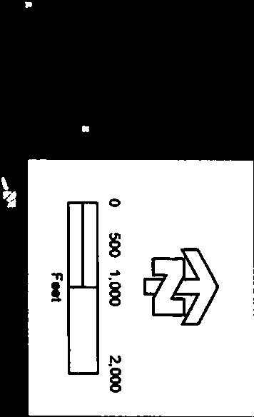
9 BOS RESOLUTION - GP AMENDMENT EXH BOS RESOLUTION - GP AMENDMENT Page 3 of 7A-1 Page 1 of 1 Page 3 of 7 NORTH WATT CORRIDOR BOUNDARY AGRICULTURAL-RESIDENTIAL (1-10 ac/du) LOW DENSITY RESIDENTIAL (1-12 ac/du) MEDIUM DENSITY RESIDENTIAL (13-30 ac/du) ANTELOPE RD URBAN-TRANSIT ORIENTED DEVELOPMENT NEIGHBORHOOD TRANSIT-ORIENTED DEVELOPMENT CORE AREA COMMERCIAL AND OFFICES INTENSIVE INDUSTRIAL Q ST INTENSIVE INDUSTRIAL (SM) EXTENSIVE INDUSTRIAL EXTENSIVE INDUSTRIAL (SM) RECREATION 34TH ST I ST SE FREEDOM PARK DR RO CEMETERY, PUBLIC & QUASI-PUBLIC (RCA) HIGH DENSITY RESIDENTIAL (31-50 ac/du) JACKSON CORRIDOR TRANSIT ORIENTED DEVELOPMENT NORTH HIGHLANDS TOWN CENTER SPA VI LL E GENERAL AGRICULTURE (80 ac) GENERAL AGRICULTURE (80 ac) (RCA) GENERAL AGRICULTURE (80 ac) (SM) URBAN DEVELOPMENT AREA CEMETERY, PUBLIC & QUASI-PUBLIC RD WATT AVE AGRICULTURAL CROPLAND (RCA) GENERAL AGRICULTURE (20 ac) GENERAL AGRICULTURE (20 ac) (RCA) I ST GENERAL AGRICULTURE (20 ac) (SM) 32ND ST ELKHORN BLVD 24TH ST REC/RCA URBAN RESERVE URBAN RESERVE (SM) NATURAL PRESERVE AGRICULTURAL CROPLAND ELKHORN BLVD MIXED USE CORRIDOR I8 0 I8 0 PALM AVE AU B UR N BL VD EXHIBIT B EXHIBIT B BELL AVE C IT Y O F SACRAMENTO I 80 EXHIBIT A-1 IN E SS ,000 2,000 Feet BU S March 1, 2012S:\GIS-Data\General_Plan\GP_Parcel Based_0710\North Watt Corridor Area_PROP_GPLU.mxd MADISON AVE North Watt Avenue Corridor Proposed Existing General Plan Land Use Designations
10 BOS RESOLUTION - GP AMENDMENT Page 4 of 7
11 BOS RESOLUTION - GP AMENDMENT EXH A-2 BOS RESOLUTION - GP AMENDMENT Page 5 of 7 Page 1 of 1 Page 5 of 7 NORTH WATT CORRIDOR BOUNDARY MIXED USE CORRIDOR ANTELOPE RD TRANSIT ORIENTED DEVELOPMENT NORTH HIGHLANDS TOWN CENTER SPA Q ST ELKHORN BLVD 34TH ST RD RO FREEDOM PARK DR SE VI LL E I ST WATT AVE I ST 32ND ST 24TH ST ELKHORN BLVD I8 0 I8 0 PALM AVE BL VD N AU BU R BELL AVE C IT Y O F SACRAMENTO 500 1,000 2,000 S 80 0 I 80 EXHIBIT A-2 BU SI NE S March 1, 2012S:\GIS-Data\General_Plan\GP_Parcel Based_0710\North Watt Corridor Area_PROP_GPLU.mxd MADISON AVE Feet North Watt Avenue Corridor Proposed General Plan Land Use Designations
12 BOS RESOLUTION - GP AMENDMENT Page 6 of 7


13 BOS RESOLUTION - GP AMENDMENT Page 7 of 7
14
15 BOS RESOLUTION (CP) Page 1 of 4 RESOLUTION NO RESOLUTION OF THE BOARD OF SUPERVISORS OF THE COUNTY OF SACRAMENTO, STATE OF CALIFORNIA, AMENDING THE NORTH WATT AVENUE CORRIDOR PLAN PORTION OF THE NORTH HIGHLANDS-FOOTHILL FARMS COMMUNITY PLAN WHEREAS, the County of Sacramento has adopted the North Highlands-Foothill Farms Community Plan for the purpose of guiding the County of Sacramento, relative to the development of said community; and WHEREAS, a public hearing on the North Watt Avenue Corridor Plan Special Planning Area project was conducted before the County Planning Commission on March 26, 2012; and WHEREAS the County Planning Commission, on March 26, 2012, forwarded its recommendation to this Board; and WHEREAS, public hearings on the North Watt Avenue Corridor Plan Special Planning Area project, were initiated before the County Board of Supervisors on ; and WHEREAS, during the hearing, the Board of Supervisors took action to amend the North Highlands-Foothill Farms Community Plan and to incorporate the appropriate designations for the North Watt Avenue Corridor Plan area; and NOW, THEREFORE, BE IT RESOLVED that the North Highlands-Foothill Farms Community Plan is amended as shown as on Page 2 of Exhibit "A" attached hereto; and BE IT FURTHER RESOLVED that the Clerk of the Board of Supervisors and the Secretary of the County Planning Commission are directed to endorse said Community Plan to show that such plan has been amended, and that such amendment has been approved by the Board of Supervisors.
16 BOS RESOLUTION (CP) Page 2 of 4 On a motion by Supervisor, Seconded by Supervisor, the foregoing resolution was passed and adopted by the Board of Supervisors of the County of Sacramento, State of California, at a regular meeting thereof this day of, 2012, by the following vote, to wit: AYES: NOES: ABSENT: ABSTAIN: Supervisors: Supervisors: Supervisors: Supervisors: CHAIRMAN OF THE BOARD OF SUPERVISORS OF SACRAMENTO COUNTY, CALIFORNIA ATTEST: CLERK OF THE BOARD OF SUPERVISORS


17 BOS RESOLUTION (CP) Page 3 of 4


18 BOS RESOLUTION (CP) Page 4 of 4
19 BOS ORDINANCE Page 1 of 2 North Watt Avenue Corridor Plan SPA PLNP follows: ORDINANCE NO. SCZ AN ORDINANCE OF THE BOARD OF SUPERVISORS OF THE COUNTY OF SACRAMENTO AMENDING THE ZONING CODE OF SACRAMENTO COUNTY, ORDINANCE NO , AS AMENDED, TO INCORPORATE THE NORTH WATT AVENUE CORRIDOR PLAN SPECIAL PLANNING AREA, IN TITLE VI, CHAPTER 12, ARTICLE 1. The Board of Supervisors of the County of Sacramento, State of California, ordains as SECTION 1: Title VI, Chapter 12, Article 1 is hereby added to the Zoning Code of Sacramento County as shown in the North Watt Avenue Corridor Plan Special Planning Area, dated March 26, 2012 and presented to this Board on July 17, 2012 with this ordinance to be incorporated herein. SECTION 2: This ordinance shall take effect and be in full force on and after thirty (30) days from the date of its passage hereof, and, before expiration of fifteen (15) days from the date of its passage, it shall be published once with the names of the members of the Board of Supervisors voting for and against the same, said publication to be made in a newspaper of general circulation published within the County of Sacramento, State of California.
20 BOS ORDINANCE Page 2 of 2 On a motion by Supervisor, seconded by Supervisor, the foregoing ordinance was passed and adopted by the Board of Supervisors of the County of Sacramento, State of California, at a regular meeting thereof this day of, 2012, by the following vote, to wit: AYES: NOES: ABSENT: ABSTAIN: Supervisors Supervisors Supervisors Supervisors CHAIRPERSON, Board of Supervisors County of Sacramento, California ATTEST: CLERK OF THE BOARD OF SUPERVISORS SS:ss OrPLNP (NorthWatt Ave) 2
21 BOS ATTACHMENT 1 Page 1 of 6
22 BOS ATTACHMENT 1 Page 2 of 6
23 BOS ATTACHMENT 1 Page 3 of 6
24 BOS ATTACHMENT 1 Page 4 of 6

25 BOS ATTACHMENT 1 Page 5 of 6

26 BOS ATTACHMENT 1 Page 6 of 6
27 Page 1 of 63 COUNTY OF SACRAMENTO CALIFORNIA PLANNING COMMISSION REPORT Control No.: PLNP Type: GPB-CZB-ZOB TO: FROM: COUNTY PLANNING COMMISSION (Final Approval by Board of Supervisors) COMMUNITY PLANNING AND DEVELOPMENT DEPARTMENT CONTACT: Tricia Stevens, Principal Planner, ; stevenst@saccounty.net Mark Manoff, Service Area Manager, ; manoffm@saccounty.net Surinder Singh, Senior Planner, ; singhsu@saccounty.net PROJECT DESCRIPTION PLNP North Watt Avenue Corridor Plan. Request for General Plan Amendment, Community Plan Amendment, Rezone and Zoning Ordinance Amendment to adopt the North Watt Avenue Corridor via a Special Planning Area ordinance, which will provide policy framework to guide future revitalization activities along the Watt Avenue corridor, in the North Highlands community. Applicant: Sacramento County Community Planning and Development Department; APN: Countywide; Environmental Document: Draft Environmental Impact Report. District 1: Phil Serna; District 3: Susan Peters; District 4: Roberta MacGlashan APPLICANT: Sacramento County Community Planning and Development Department Planning Division th Street, Room 230 Sacramento, CA 95814
28 Page 2 of 63 NORTH WATT AVENUE CORRIDOR PLAN PLNP2008-GPB-CZB-ZOB DETAILED REQUEST: 1. A General Plan Amendment to change the General Plan designation from Agricultural Residential (36.18 acres), Commercial Offices ( acres), Industrial Intensive ( acres), Low Density Residential (68.30 acres), Medium Density Residential (11.28 acres), Recreation (8.74 acres) with a Mixed Use Corridor overlay to Transit Oriented Development with a Mixed Use Corridor overlay. 2. A General Plan Amendment to change the General Plan Transportation Plan to add the Smart Growth Street designation for Watt Avenue from I- 80 north to U Street. 3. A Community Plan Amendment and Corresponding Rezone to Special Planning Area from Auto Commercial (AC) (9.03 acres), Business and Professional (BP) (6.84 acres), General Commercial (GC) ( acres), Highway Travel Commercial (TC) (14.60 acres), Limited Commercial (LC) (59.96 acres), Shopping Center (SC) (53.19 acres), Recreation (O) (7.24 acres), Agricultural-Residential (AR-1) (0.10 acres), Residential Density 2 (RD-2) (32.80 acres), Residential Density 5 (RD-5) (5.43 acres), Residential Density 10 (RD-10) (0.16 acres), Residential Density 20 (RD-20) (9.27 acres), Residential Density 30 (RD-30) (5.37 acres), Mobilehome Subdivision (RM-1) (1.41 acres), Light Industrial (M-1) ( acres), Office Park (MP) (25.14 acres), Special Planning Area (SPA) (55.24 acres), and Neighborhood Preservation Area (NPA) (0.28 acres), on approximately acres. 4. A Zoning Ordinance Amendment to create the North Watt Ave Special Planning Area. SS:ss:gvc PLNP
29 Page 3 of 63 NORTH WATT AVENUE CORRIDOR PLAN PLNP2008-GPB-CZB-ZOB Overview: As part of an overarching countywide program aimed at implementing the General Plan, the North Watt Avenue Corridor Plan (NWACP) was initiated to provide for a comprehensive planning strategy promoting high-quality infill growth, transportation choices, and infrastructure improvements for the North Watt corridor area. The NWACP establishes a policy framework to guide the transition of the North Watt corridor area from an auto-oriented commercial district serving a former military base to a series of urban villages integrated within the North Highlands community. The Plan also provides for a cohesive and coordinating strategy aimed at attracting both public and private investments to the area. The NWACP includes strategies to concentrate mixed uses nodes and residential development at the Elkhorn, North Highlands Town Center and Triangle District Centers. The plan also includes robust long term strategies to transform the Triangle District (strategically located adjacent to freeway 1-80, McClellan Park and the Watt Avenue light rail station) from a mostly light industrial area to Transit-Oriented Development area that combines residential, employment, shopping and services with improved transit service. Summary of Significant Issues: The NWACP has taken shape through a collaborative process between community stakeholders, residential property owners and the County entities including Planning, Neighborhood Services, Transportation and Economic Development. The NWACP effort and community outreach was led by a Steering Committee consisting of representatives from the North Highlands Vision Task Force, North Highlands Community Advisory Council, McClellan Park, Antelope Chamber of Commerce, and SAFE Credit Union. The proposed SPA has been reviewed extensively by the Steering Committee and by the community at large. The SPA has been revised throughout the process to address public comments. It is believed that there is a consensus on the part of stakeholders that the proposed SPA meets the needs of the business community and the community at large. Several area residents have contacted staff to voice their concerns regarding the potential urbanization of the West of Watt area. It is important to note that the NWACP does not master plan West of Watt. This area will be subject to a separate master planning process. CPAC Recommendation: The North Highlands-Foothill Farms Community Planning Advisory Council (CPAC) met on November 22, 2011 and recommended APPROVAL (6-0) of the proposed project, including all new revisions proposed to the NWACP, as shown in Attachment A. Many questions were raised during this meeting; however, no one spoke in opposition to this Corridor Plan. Planning Department Recommendation: Staff is recommending APPROVAL of the proposed project. SS:ss:gvc PLNP
30 Page 4 of 63 NORTH WATT AVENUE CORRIDOR PLAN PLNP2008-GPB-CZB-ZOB I. Location Map 4 II. Environmental Analysis 5 III. Project Analysis 5 IV. Staff Recommendations 30 V. Attachments 32 VI. Exhibits 32 SS:ss:gvc PLNP
31 BOS ATTACHMENT 2 Page 5 of 63 NORTH WATT AVENUE CORRIDOR PLAN PLNP2008-GPB-CZB-ZOB I. LOCATION MAP SS:ss:gvc PLNP
32 Page 6 of 63 NORTH WATT AVENUE CORRIDOR PLAN PLNP2008-GPB-CZB-ZOB II. ENVIRONMENTAL ANALYSIS A. Environmental Setting: Watt Avenue is a major thoroughfare connecting Placer County with the Sacramento County communities of Vineyards, Antelope, North Highlands, Arden Arcade, and Elk Grove. The NWACP area consists of approximately 750 acres distributed along a 4-mile segment of Watt Avenue north of I-80 to Antelope Road, in the unincorporated community of North Highlands. The Corridor Plan area is bordered on the west by McClellan Business Park and the area known informally as West of Watt. Established single-family residential neighborhoods in the North Highlands community border the Corridor Plan area on the east. The NWACP area can be generally characterized as an aging auto-oriented commercial corridor that was built to serve employees of the former McClellan Air Force Base. The NWACP consists of several commercial strips with buildings that are placed well back from Watt Avenue areas and large parking areas fronting the corridor. Many of the parcels within the corridor area are zoned for commercial and residential uses. The commercial and office designations include Limited Commercial (LC), Auto Commercial (AC), General Commercial (GC), Travel Commercial (TC) and Business and Professional (BP) zoning. The project area also includes a number of areas developed with single family residential (RD-5 and RD- 10) and medium density residential (RD-20 and RD-30) uses. B. Environmental Effects and Suggested Mitigation Measures: The Draft Environmental Impact Report (DEIR) dated September 2011 identifies potential impacts associated with land use compatibility, water services, sewer services, ozone precursor and diesel particulate emissions caused by construction activities, ozone precursor and diesel particulate emissions caused by high traffic roadways and railroad, interior noise, biological resources, climate change emissions, prehistoric and historic archaeological resources and contamination sites are considered potentially significant impacts but could be reduced to a less than significant level with recommended mitigation measures. The DEIR also concludes that that impacts associated to airport safety zones, study road segments and intersections, study freeway facilities, fugitive dust, operational emissions, exterior noise, and historic architectural resources are considered significant and unavoidable. Impacts associated with General Plan, Zoning Code, airport noise, navigable airspace, drainage and hydrology, fire and emergency services, law enforcement, solid waste, schools, park and recreation services, energy services, construction noise, formally evaluated historical resources and exposure to lead based paint and asbestos are considered less than significant. III. PROJECT ANALYSIS A. History/Background: North Watt Avenue, similar to several other older commercial corridors in the county, reflects a historic pattern of auto-oriented design concepts rather than pedestrian oriented development. The corridor area currently consists of a SS:ss:gvc PLNP
33 Page 7 of 63 NORTH WATT AVENUE CORRIDOR PLAN PLNP2008-GPB-CZB-ZOB SS:ss:gvc PLNP range of shopping and services that are arranged in strip centers with good visibility to passing motorists on the street and parking located in the front. These auto oriented design concepts have limited safe and pleasant access for non-motorists such as bicyclists and pedestrians. Pedestrians crossings are now limited at signalized intersections while cyclists must contend with discontinued lanes, in some cases riding on the shoulder of the street. The North Watt Corridor Plan was initiated in 2005 as part of overall strategy to address the revitalization of the North Watt Corridor and the North Highlands community, especially in the context of the 1995 closing of McClellan Air Force Base. The North Highlands community is intricately tied to McClellan Business Park and its success. Main components of this strategy include: Adoption of the McClellan Reuse Plan and Special Planning Area, Adoption of the McClellan Redevelopment Area, Adoption of the North Watt Avenue Beautification Master Plan and completion of major street improvements to the Avenue, Adoption of the North Highlands Town Center Development Code (SPA) for the Freedom Park Drive area, Development of the North Watt Corridor Plan for the entire Corridor, and Future consideration of the West of Watt area (existing agricultural-residential and industrial area) as future urban growth area. B. Project Size and Boundaries: The North Watt Avenue Corridor is located along Watt Avenue from Interstate-80 on the south end to Antelope Road/U Street on the north end. The Corridor Plan consists of approximately 720 acres distributed along a 4- mile stretch of Watt Avenue located within the North Highlands community of the unincorporated Sacramento County. The Corridor Plan area is generally situated between the McClellan Business Park and an area informally called West of Watt to the west and single-family residential neighborhoods in the North Highlands community to the east. C. Purpose and Objectives of Corridor Plan: The NWACP program was initiated in 2005 to provide a comprehensive strategy to guide infill growth and public improvements along North Watt Avenue and throughout the Corridor Plan area within a planning horizon of 20 years. This is also an important component of the County General Plan implementation. The document has been crafted from the generous input of community residents, business representatives, and agency staff and is based on their goals and priorities. The Corridor Plan has been crafted based upon the following set of priorities that were identified by the community: a greater variety of housing types; more efficient access to local destinations by walking, biking, transit, and driving; 7
34 Page 8 of 63 NORTH WATT AVENUE CORRIDOR PLAN PLNP2008-GPB-CZB-ZOB improved aesthetics along North Watt Avenue, including updated architecture, signage, and site planning; revitalization of vacant lots and vacant or underutilized buildings; incorporation of the aeronautic and agricultural history into design features (such as signage) to contribute to the visual expression of a positive community character; new commercial centers, such as the North Highlands Town Center, that can better serve the community s needs for shopping, services, and entertainment, and strengthen local community by providing public gathering places; and long term strategies to transform the Triangle District from a mostly light industrial area to Transit-Oriented Development area that combines residential, employment, shopping and services with improved transit service. This area is recognized as a key economic development opportunity site. D. North Watt Avenue Corridor Plan Planning Process: The NWACP has taken shape through a collaborative process between community stakeholders, residential property owners, Sacramento Housing and Redevelopment Agency (SHRA) and several County departments including Planning, Economic Development, Transportation and Neighborhood Services. The corridor planning effort and community outreach was led by a Steering Committee which consisted of representatives from the following entities: North Highlands Community Planning Advisory Council, North Highlands Vision Task Force, McClellan Business Park, SAFE Credit Union, Antelope Chamber of Commerce and North Highlands Park and Recreation District. Led by the Steering Committee, community outreach has consisted of the following components: stakeholder interviews, storefront workshops and community meetings. E. SPA Vision and Guiding Principles: The Corridor Plan is intended to guide infill growth and public improvements along North Watt Avenue and throughout the Corridor Plan area within a planning horizon of 20 years. The Corridor Plan recognizes the importance of Watt Avenue as a regional resource serving multiple jurisdictions and represents a comprehensive planning strategy promoting highquality infill growth, transportation choices, and infrastructure improvements for the Corridor Plan area. The Corridor Plan identifies existing features suitable for preservation and enhancement, such as creek corridors traversing the area. Strategies for redevelopment of vacant and underutilized properties are suggested to increase employment and housing opportunities. The Vision Statement of the Corridor Plan states: The Corridor Plan is a comprehensive guide to the implementation of the community s vision for a vibrant, economically healthy corridor that enhances the quality of life in North Highlands and the greater Sacramento region. The Corridor Plan seeks to achieve these goals by emphasizing the following principles: SS:ss:gvc PLNP
35 Page 9 of 63 NORTH WATT AVENUE CORRIDOR PLAN PLNP2008-GPB-CZB-ZOB SS:ss:gvc PLNP Concentration of higher density/intensity mixed-use employment and residential infill development at the district centers (Elkhorn, North Highlands Town Center, and Triangle Gateway) and establishment of new residential mixed-use neighborhoods in districts outside the district centers; Redevelopment of vacant and underutilized properties to promote the economic viability of the area; An interconnected circulation system with multimodal transportation opportunities to support community and regional mobility and access; Coordination with McClellan Business Park to encourage the continued growth of the regional employment center; Preservation and enhancement of natural resources to promote long-term sustainability of the community; Promotion of the area s existing character to create a sense of place and attract regional visitation; Provision of adequate infrastructure to support the proposed development; and Endorsement of exemplary and sustainable urban design and construction resulting in high-quality buildings and an inviting public realm supporting a high level of pedestrian activity. F. North Watt Avenue Corridor Plan Project Description: The proposed NWACP project consists of a General Plan Amendment to amend the Land Use Diagram and Transportation Plan of the 2030 General Plan. The project proposes to add a Smart Growth Street designation for Watt Avenue from I-80 north to U Street. The project also includes a Community Plan Amendment and Rezone to change the existing zoning designations to the North Watt Avenue Special Planning Area (SPA) for approximately gross acres of land located within the corridor plan area. Also included is a Zoning Ordinance Amendment to incorporate the NWA SPA as part of the County Zoning Code. Project boundaries are accurately depicted in the Location Map shown on page 5 of this report. Prior to the final approval of the project, the SPA document will be updated to show accurate boundaries of the plan area. G. Organization of the North Watt Avenue SPA: The NWA SPA is broken into six separate chapters, as described below: 1. Introduction: Provides an overview of the Plan s purpose and brief description of the districts and district centers. This section includes a vision statement and guiding principles that will direct future development in the Corridor Plan area. 2. Land Use: Provides a detailed description of the desired character for each district and district center. Defines proposed land use patterns and provides target densities and intensities. Identifies General Plan and zoning designations, including new mixed-use designations 9
36 Page 10 of 63 NORTH WATT AVENUE CORRIDOR PLAN PLNP2008-GPB-CZB-ZOB SS:ss:gvc PLNP Urban Design: This section includes text and illustrative graphics to define the standards and guidelines for infill development in the Corridor Plan area. 4. Circulation: This section describes short-term and long-term alternatives for street improvements in the Corridor Plan area. Addresses auto, transit, neighborhood electric vehicle, bicycle, and pedestrian circulation and access. 5. Public Realm Design: Addresses streetscape standards and improvements, landscaping and street trees, parks and open space, signage, and public art. 6. Infrastructure: Addresses the sewer, water, and stormwater infrastructure improvements that will be necessary to support the proposed development. H. Key Components of the North Watt Corridor Plan: The NWA Corridor Plan has been prepared to establish a policy framework and standards in order to guide the transition of corridor from an auto-oriented commercial district serving a former military base to a series of urban villages integrated within the North Highlands community. To achieve that vision, the NWACP focuses of the following five key areas: Planning Area Districts and Vision Land Use Plan Circulation Plan Land Use Tables Development Standards and Design Guidelines 1. Planning Area Districts and Vision: The Corridor Plan area encompasses varied development patterns and land uses across a large, diverse area. For planning purposes, the Corridor Plan has been subdivided into three distinct districts (i.e., Elkhorn, Town Center, and Triangle Gateway) based on smart growth principles that promote higher residential densities and nonresidential intensities that support transit. The districts, centers and sub districts are depicted in Figure 1 on the next page. Development potential for each district is listed below. District Residential (Dwelling Units) 10 Retail (Square Feet) Office (Square Feet) Elkhorn District: Elkhorn District Center , ,230 Remainder of District 1,418 87,750 22,026 SubTotal 2, , ,255 NH Town Center District NH Town Center 1,824 29,250 26,970 Remainder of District , ,880 Subtotal 2, , ,850 Triangle District Triangle District Center ,000 71,920 Remainder of District 1, , ,680 Subtotal 2, , ,600 Corridor Plan Total 7,200 1,170, ,700

37 Page 11 of 63 NORTH WATT AVENUE CORRIDOR PLAN PLNP2008-GPB-CZB-ZOB Figure 1 Districts and District Centers SS:ss:gvc PLNP
38 Page 12 of 63 NORTH WATT AVENUE CORRIDOR PLAN PLNP2008-GPB-CZB-ZOB SS:ss:gvc PLNP Elkhorn District and Elkhorn District Center: As shown in Figure 1, the Elkhorn District area is located between Antelope Road and I Street. The smaller Elkhorn District Center is envisioned as an employment and residential mixed-use center, with commercial/retail uses fronting onto Elkhorn Boulevard. Office and higher density residential development may be located above this commercial frontage and in the remainder of the district center. All development in the district center should be developed at sufficient densities and intensities to support local bus stops and one or more bus rapid transit stations. Areas north and south of the District Center, within the larger Elkhorn District, will be primarily residential, with some limited neighborhood-serving nonresidential uses. Town Center District and North Highlands Town Center: The North Highlands Town Center District is located between I street and Peacekeeper Way. Included in this district is the North Highland Town Center which is envisioned as the civic heart of the North Highlands community. As defined by the approved North Highlands Town Center Development Code, the Town Center area, located along Freedom Park Drive, will include civic, commercial/retail and residential uses. The Development Code also provides for improvements to Freedom Park Drive and upgrades to existing local streets. The area north of the North Highlands Town Center will include medium to higher density residential uses, with some limited nonresidential development, while the southern Town Center District area will include intensive development due to its proximity to major gateways into McClellan Business Park at James Way and Peacekeeper Way. Triangle Gateway District: Due to the area s close proximity to regional employment opportunities at McClellan Business Park and regional transit access at the Watt Avenue light rail station, the Plan envisions the Triangle Gateway District area as a Transit-Oriented Development area with a focus on regional retail and employment uses. The NWACP divides the Triangle Gateway district into three sub districts (1, 2, and 3). These sub districts provide a more fine-grained response to opportunities and constraints including the presence of the North Area Recovery Station and noise from air traffic in McClellan Business Park. Subdistrict 1, located at the northern tip, is not constrained by noise or proximity to the County s transfer station, and thus represents one of the better opportunities for residential development. Subdistrict 2 takes advantage of several vacant properties and past land assembly to create a mixed-use district with ground floor commercial/retail frontage on Watt and internal local streets. Subdistrict 3 is designed to capitalize on its proximity to I-80 and the two light rail transit stations, and includes higher intensity office uses, with residential potentially located at the southeast corner of the district. 12
39 Page 13 of 63 NORTH WATT AVENUE CORRIDOR PLAN PLNP2008-GPB-CZB-ZOB Land Use Plan: The NWACP will be designated as the North Watt Avenue Special Planning Area (SPA) under Title V of the Sacramento County Zoning Code. All properties with the Corridor Plan area will be rezoned to NWA SPA except for those properties located within the North Highlands Town Center SPA. These properties will be guided by the approved North Highland Town Center SPA. The NWA SPA has been prepared to complement the plans, goals, objectives of the North Highlands Town Center SPA. In addition to rezoning properties to the SPA, the NWACP also proposes another level of zoning generally consisting of more specific zoning designations for the mixed use developments to ensure orderly development within the corridor area. The four specific zoning designations include Residential Mixed-Use 1, Residential Mixed-Use 2, Commercial Mixed-Use and Transit-Oriented Development zones. Figure 2 denotes the locations of these zones while the following section provides a summary of these specific zoning designations. Residential Mixed-Use 1 (RMU-1): The RMU-1 zoning designation is intended to promote the development of medium-density residential neighborhoods supported by small, neighborhood-serving service and retail nodes. Residential units may include a variety of housing types, including small-lot, single-family and duet homes; attached and detached townhouses; green court, garden, and tuck-under apartments and condominiums; and live-work units. Nonresidential uses are permitted in the RMU-1 zone, but are not required. Any nonresidential use must be located at an intersection of a collector or local street with Watt Avenue or 34th Street. Vertical or horizontal formats are permitted. If nonresidential uses are combined with residential uses in a single building, the nonresidential uses must be located on the ground floor fronting onto the street. Residential Mixed-Use 2 (RMU-2): The RMU-2 zoning designation is intended to promote the development of mixed-use residential neighborhoods with densities sufficient to minimize automobile dependence and support bus rapid transit. Residential units may include a variety of housing types, including attached townhouses; green court, garden, and tuck-under apartments and condominiums; and live-work units. Additional housing types are acceptable provided that they meet the development standards specified under RMU-2 zoning. RMU-2 neighborhoods will be predominantly residential, but may also include office, commercial/retail, or civic/public uses. Nonresidential uses are permitted in the RMU-2 zone, but are not required. Vertical or horizontal formats are permitted. SS:ss:gvc PLNP

40 Page 14 of 63 NORTH WATT AVENUE CORRIDOR PLAN PLNP2008-GPB-CZB-ZOB Figure 2 Proposed Zoning Exhibit SS:ss:gvc PLNP
41 Page 15 of 63 NORTH WATT AVENUE CORRIDOR PLAN PLNP2008-GPB-CZB-ZOB Commercial Mixed-Use (CMU): The CMU-2 zoning designation is intended to promote a shopping and service district concentrated along Elkhorn Boulevard. Development may be in vertical or horizontal formats, but ground floor commercial/retail or office uses are required on Elkhorn Boulevard. Residential units in the CMU zone may be constructed behind or above commercial street frontage. These units may also be wrapped by nonresidential uses at the ground floor level on Elkhorn Boulevard. Residential uses in the CMU zone may be located in stand-alone buildings if not adjacent to primary commercial street frontage on Elkhorn Boulevard. Transit-Oriented Development (TOD): The TOD zoning designation is intended to promote higher density and intensity region-serving development near regional transit opportunities. Higher density residential uses are encouraged in Subdistrict 1 and may be green court or garden style apartments or condominiums, podium-style apartments or condominiums, or any other suitable residential model that meets the development standards of this zone. Commercial/retail, hotel, and entertainment uses are encouraged in Subdistrict 2. Office uses may be located anywhere in the TOD, but are particularly encouraged near Roseville Road or in the southern portion of the TOD near I Circulation Plan: The NWACP circulation framework has been devised to encompass the full range of mobility choices including local and regional bus rapid transit, automobiles, neighborhood electric vehicles, bicycles and pedestrian traffic. The plan focuses on North Watt Avenue and 34th Street, in particular, which are designed to accommodate many of the design features of complete streets that encourage walkability and transit use. The Circulation Plan, shown as Figure 3, identifies proposed improvements to other existing streets and the construction of new streets. The potential location and patterning of new streets are guided by the following principles: New streets and upgrades to existing streets should accommodate the full range of mobility options suitable to the type of street, as identified in the street sections. To accomplish this, it may be necessary for some streets to function at Level of Service F. New streets should be designed as a modified grid system, with block perimeters no greater than 400 feet. Existing streets should be extended, where warranted, to improve eastwest connectivity through the Corridor Plan area. However, many of the streets on the west side of Watt Avenue will be local-serving only, since signalized cross-traffic should be minimized on Watt Avenue to increase efficiency. SS:ss:gvc PLNP
42 Page 16 of 63 NORTH WATT AVENUE CORRIDOR PLAN PLNP2008-GPB-CZB-ZOB Figure 3 Circulation Plan W a t t A v e n u e a n d 3 4 t h S t r e e t s w i l l c o n SS:ss:gvc PLNP
43 Page 17 of 63 NORTH WATT AVENUE CORRIDOR PLAN PLNP2008-GPB-CZB-ZOB Watt Avenue and 34th Streets will convey regional and local north-south traffic. New north-south streets should be designed to carry local traffic and terminate at major roads, parks, or open space corridors to discourage use as an alternative to Watt Avenue and 34th Streets. New streets should respect the location of existing creek corridors whenever possible. Creeks should not be undergrounded or rerouted simply to accommodate new street alignments. Where a creek or drainage corridor has been modified and does not represent a desirable alignment for the creek itself, this may be modified to enhance the sustainability of the open space corridor. NWACP further identifies several near term transportation improvement plans for Watt Avenue and 34 th Street. The four-lane section of Watt Avenue would be widened to six lanes and extended to Antelope Road. The six lanes would serve as travel lanes, with the outside lanes facilitating transit movement. The northbound and southbound lanes of Watt Avenue would be separated by a raised, landscaped median. Transit improvements would include transit signal priority and queue jumps. Pedestrian improvements include sidewalks and onstreet Class II bicycle lanes to be installed along the entire length of Watt Avenue on both sides of the street. Near term roadway improvements planned for 34 th Street (i.e. from Antelope Road to Peacekeeper Way) includes the installation of two paved travel lanes and Class II bicycle lanes, a landscape strip, and continuous sidewalks. The near term alternative preserves the existing right-of-way on 34th Street and creates a continuous landscape canopy along the street. Traffic calming measures would also be installed at key intersections to preserve the existing neighborhood character of the street and minimize cut-through traffic. 4. Land Use Tables: The Draft NWACP includes land use tables that list permitted and prohibitive uses for each of the following four zoning designations shown on the land use plan: Residential Mixed-Use 1, Residential Mixed-Use 2, Commercial Mixed-Use, and Transit-Oriented Development. Permitted uses are those uses that are allowed by right without the need for discretionary review by any hearing body including the County Planning Commission or Board of Supervisors. Prohibited uses are those not allowed under any condition within each of the four zoning categories. Following the release of the Draft Corridor Plan in April 2009, staff has replaced each individual land use table, as shown in the Draft NWACP document, with an expanded single comprehensive land use table which now lists many new land uses. This new table is provided as Attachment D. The revised land use table allows mixed use developments, single family residential and apartments in all districts while the following uses are prohibited for each zoning category: SS:ss:gvc PLNP
44 Page 18 of 63 NORTH WATT AVENUE CORRIDOR PLAN PLNP2008-GPB-CZB-ZOB Tattoo Parlors Pawn Shops Adult Uses Firearm Sales & Gunsmith Check Cashing Adult Theater & Entertainment Automobile Sales Automobile Towing Car Wash Major Auto Service and Repair 5. Development Standards and Design Guidelines: Chapter 3, Urban Design, of the NWACP, includes specific development standards and design guidelines that will promote the desired urban form and character and create a healthy community with defined districts and community destinations. The standards and guidelines have been prepared to promote the transit-supportive uses identified for the Elkhorn District Center and Triangle Gateway District and the creation of medium density mixed-use neighborhoods. The standards and guidelines have also been devised to promote the creation of local subdistricts reflecting the variety to be found in the Corridor Plan area. Chapter 3 also includes a chart for each specific district which speaks to numeric standards such as maximum height, setbacks, and distance from single family residential, and parking. This chapter is supported by Chapter 5, Public Realm Design, for design standards and guidelines addressing the public realm, including streetscapes, landscaping, parks, open space, trails, signage, street furniture, and other improvements that will enhance the image and identity of the Corridor Plan area. I. Consistency with General Plan: The NWACP includes land use regulations, development densities and intensities, and design guidelines to accomplish the following key objectives: create a vibrant, mixed use village center that serves as a community amenity area for the North Watt Avenue corridor and greater North Highlands; encourage infill development that will complement and enhance the local economic base and quality of life; and, redevelop blighted and underutilized properties for productive uses. The NWACP is an important component of implementing the County s General Plan which places a greater emphasis on community design and the revitalization of the county s underutilized commercial corridors as mixed use streets. The project meets the intent of General Plan Policy LU-11 which indicates that It is the intent of the County to comprehensively plan for the revitalization of the targeted commercial corridors and invest the resources necessary to achieve the following: stimulate private investment; encourage development of vacant and underutilized parcels; support reuse and/or rehabilitation of abandoned or blighted buildings; encourage rezoning of excess industrial and commercial lands to allow for medium and high SS:ss:gvc PLNP
45 Page 19 of 63 NORTH WATT AVENUE CORRIDOR PLAN PLNP2008-GPB-CZB-ZOB density residential or mixed use projects, and; avoid non transit supportive uses, such as industrial uses, low density residential, and uses that would necessitate large parking lots fronting on the street. Additionally, the NWACP has been initiated to implement several key planning and growth management strategies of the General Plan relating to the establishment of mixed use centers and infrastructure re-investment. The overall approach of the corridor planning program seeks to implement the following General Plan policies: LU-89. Support planning for and development of mixed use centers and urban villages along commercial corridors to improve quality of life by creating diverse neighborhood gathering places, supporting enhanced transit service and non-automotive travel, stimulating local economic development, eliminating blight and balancing land uses. LU-90. Focus investment of County resources in commercial corridors to facilitate improvements to streetscapes, sidewalks, landscaping, undergrounding of utilities, and other infrastructure and public amenities to encourage and stimulate private investment. The character of the NWACP complies with General Plan Policy LU-20 which specifies Planning processes for existing communities, commercial corridors and new growth areas shall provide for distinct and identifying physical elements, which may include: gateways, signage, public art, common site or street layout, shared design qualities of buildings or infrastructure, or prominent landmarks or destinations. The NWACP is consistent with the Policy LU-23 Providing compact, mixed use developments shall be an integral part of all master planning efforts for new growth areas and commercial corridors. The SPA includes robust policies and design guidelines that support the development of these nodes as community focal areas and to create a sense of place for the community. Many of the planning principles cited in smart street policies of the General Plan, including pleasant walking environments, streetscape features, and direct and multiple linkages for walking and biking have been incorporated into the design of the NWACP. An Air Quality Mitigation Plan has been prepared for the project which requires the implementation of Plan-wide and project-specific emission reduction measures to achieve a of percent reduction in operational and areas source emissions, consistent with General Plan Policy AQ-4. The Air Quality Plan is provided as Attachment C. This table on the next page of this report shows significant policies in the General Plan that are relevant to this project. The second column is a brief response as to whether or not the project is consistent with General Plan policies. SS:ss:gvc PLNP
46 Page 20 of 63 NORTH WATT AVENUE CORRIDOR PLAN PLNP2008-GPB-CZB-ZOB General Plan Consistency Land Use Policies Key Policy LAND USE ELEMENT: LU-3 It is the intent of the County to focus investment of public resources on revitalization efforts within existing communities, especially within commercial corridors, while also allowing planning and development to occur within strategic new growth areas. LU-4 The County shall give priority to residential development on vacant or underutilized sites within existing urban areas which have infrastructure capacity available. LU-6 Provide for the development of vacant or underutilized portions of commercial projects and industrial-office parks with medium or high-density residential uses or mixed-use development where appropriate, such as near existing or planned transit service. LU-7 Provide for additional mixed use development in commercial parking areas where such uses would be compatible with surrounding uses and where parking demand can be appropriately accommodated or structured parking can be constructed. LU-11 It is the intent of the County to comprehensively plan for the revitalization of the targeted commercial corridors and invest the resources necessary to achieve the following: stimulate private investment; encourage development of vacant and underutilized parcels; support reuse and/or rehabilitation of abandoned or blighted buildings; encourage rezoning of excess industrial and commercial lands to allow for medium and high density residential or mixed use projects, and; avoid non transit supportive uses, such as industrial uses, low density residential, and uses that would necessitate large parking lots fronting on the street. LU-16 Apply the Community Design Guidelines and design review authority to all long-range planning efforts, including but not limited to Specific Plans, Comprehensive Plans, Community Plans, and Commercial Corridor Plans. LU-17 Support implementation of the design review program on a project-by-project basis to ensure that all development applications positively contribute to the immediate neighborhood and surrounding community. LU-18 Encourage development that compliments the aesthetic style and character of existing development nearby to help build a cohesive identity for the area. LU-19 Incompatible urban land uses should be buffered from one another by methods that retain community character, and do not consume large land areas or create pedestrian barriers. LU-20 Planning processes for existing communities, commercial corridors and new growth areas shall provide for distinct and identifying physical elements, which may include: gateways, signage, public art, common site or street layout, shared design qualities of buildings or infrastructure, or prominent landmarks or destinations. LU-21 Promote a better balance of employment, neighborhood services, and different housing types by reviewing development projects and the surrounding community and designing new projects wherever feasible so that they maintain or improve the mix of uses in the community. LU-23 Providing compact, mixed use developments shall be an integral part of all master planning efforts for new growth areas and commercial corridors. LU-24 Support private development requests that propose pedestrian and transit-friendly mixed use projects in commercial corridors, town centers, and near existing or proposed transit stops. Consistency Yes Yes Yes Yes Yes Yes Yes Yes Yes Yes Yes Yes Yes SS:ss:gvc PLNP
47 Page 21 of 63 NORTH WATT AVENUE CORRIDOR PLAN PLNP2008-GPB-CZB-ZOB Key Policy LU-27 Provide safe, interesting and convenient environments for pedestrians and bicyclists, including inviting and adequately-lit streetscapes, networks of trails, paths and parks and open spaces located near residences, to encourage regular exercise and reduce vehicular emissions. LU-37 Provide and support development of pedestrian and bicycle connections between transit stations and nearby residential, commercial, employment or civic uses by eliminating physical barriers and providing linking facilities, such as pedestrian overcrossings, trails, wide sidewalks and safe street crossings. LU-39 Support implementation of the ADA Transitional Plan and the Pedestrian Master Plan to create a network of safe, accessible and appealing pedestrian facilities and environments. LU-43 Parking areas shall be designed to: minimize land consumption, provide pleasant and safe pedestrian and bicycle movement, facilitate shared parking, allow for the possible reuse of surface parking lots through redevelopment; and, minimize parking lot street frontage. LU-48. Discourage the establishment and build-out of linear, strip pattern, commercial centers. LU-89 Support planning for and development of mixed-use centers and urban villages along commercial corridors to improve quality of life by creating diverse neighborhood gathering places, supporting enhanced transit service and non-automotive travel, stimulating local economic development, eliminating blight and balancing land uses. LU-90 Focus investment of County resources in commercial corridors to facilitate improvements to streetscapes, sidewalks, landscaping, undergrounding of utilities, and other infrastructure and public amenities to encourage and stimulate private investment. LU-91 Support district planning efforts that focus on specific areas in need of reinvestment and revitalization LU-92 Support development of a bus rapid transit system and light rail expansion by encouraging appropriate land uses and densities along planned routes Consistency Yes Yes Yes Yes Yes Yes Yes Yes Yes General Plan Consistency Circulation, Air Quality and Housing Element Policies Key Policy CIRCULATION ELEMENT: CI-1 Provide complete streets to provide safe and efficient access to a diversity of travel modes for all urban, suburban and rural land uses within Sacramento County except within certain established neighborhoods where particular amenities (such as sidewalks) are not desired. Within rural areas of the County, a complete street may be accommodated through roadway shoulders of sufficient width or other means to accommodate all modes of travel. CI-3 Travel modes shall be interconnected to form an integrated, coordinated and balanced multimodal transportation system, planned and developed consistent with the land uses to be served CI-4 Provide multiple transportation choices to link housing, recreational, employment, commercial, educational, and social services. CI-20 Promote transit services in appropriate commercial corridors and where population and employment densities are sufficient or could be increased to support those transit services Consistency Yes Yes Yes Yes SS:ss:gvc PLNP
48 Page 22 of 63 NORTH WATT AVENUE CORRIDOR PLAN PLNP2008-GPB-CZB-ZOB Key Policy CI-32 Develop a comprehensive, safe, convenient and accessible bicycle and pedestrian system that serves and connects the County's employment, commercial, recreational, educational, social services, housing and other transportation modes. CI-69 Incorporate public art into streetscape improvements to the extent feasible CI-70 Smart Growth Streets shall incorporate features such as shade trees and plantings, well designed benches and other street furniture, trash receptacles, news racks, outdoor dining experiences, entertainment, public art, pedestrian scaled lighting fixtures, wayfinding signage, bicycle racks and other amenities as appropriate CI-74 Evaluation of Smart Growth Street corridors and development within those corridors shall utilize multi-modal level of service standards, including pedestrian, bicycle, and transit modes of travel in addition to motor vehicle travel, to support and encourage overall mobility through improvement to all modes of travel. CI-76 Smart Growth Street planning efforts shall develop a comprehensive strategy to reduce both the total amount of parking and total surface area dedicated to parking facilities. In general, reduced parking requirements and innovative parking solutions such as, shared parking, structured parking, parking maximums rather than minimums, on street parking, performance parking pricing, parking benefit districts and other innovative parking solutions will be strongly encouraged wherever feasible, while large surface parking lots will be strongly discouraged CI-77 Planning processes for Smart Growth Street corridors shall consider road diets, pedestrian and bicycle enhancements, traffic calming measures and other feasible measures to create a corridor that equitably accommodates all users and modes of travel CI-78 Establish connectivity standards to implement within Smart Growth Street corridors, to ensure safe, pleasant and direct travel between destinations for all users AIR QUALITY ELEMENT: AQ-1 New development shall be designed to promote pedestrian/bicycle access and circulation to encourage community residents to use alternative modes of transportation to conserve air quality and minimize direct and indirect emission of air contaminants AQ-4 Developments which meet or exceed thresholds of significance for ozone precursor pollutants as adopted by the Sacramento Metropolitan Air Quality Management District (SMAQMD), shall be deemed to have a significant environmental impact. An Air Quality Mitigation Plan shall be submitted to the County of Sacramento prior to project approval, subject to review and recommendation as to technical adequacy by the Sacramento Metropolitan Air Quality Management District AQ-8 Promote mixed-use development and provide for increased development intensity along existing and proposed transit corridors to reduce the length and frequency of vehicle trips AQ-20 Promote Cool Community strategies to cool the urban heat island, reduce energy use and ozone formation, and maximize air quality benefits by encouraging four main strategies including, but not limited to: plant trees, selective use of vegetation for landscaping, install cool roofing, and install cool pavements HOUSING ELEMENT: HE-3 Utilize appropriate surplus federal, state, and County land within Sacramento County for affordable housing development. Consistency Yes Yes Yes Yes Yes Yes Yes Yes Yes Yes Yes Yes SS:ss:gvc PLNP
49 Page 23 of 63 NORTH WATT AVENUE CORRIDOR PLAN PLNP2008-GPB-CZB-ZOB Key Policy HE-4 Support development proposals that seek to locate new market rate multi-family uses at strategic locations along transportation corridors and at transit stops and stations, or at other strategically located reuse and underdeveloped sites. HE-5 Promote and facilitate the build-out of vacant and underutilized urban land through infill, reuse, and redevelopment activities, as appropriate, for housing including: 1. Support for a variety of housing types on vacant sites suitable for urban infill, in both residential only and mixed-use developments; and 2. Reuse of older commercial and retail properties, industrial and business office parks, and access surface parking areas of regional malls, to allow additional residential development within the existing urban area. Consistency Yes Yes J. Summary of Project Related Issues: During the preparation of the NWACP, a number of issues relating to the corridor area were raised by area residents and business owners. Following is a summary of the main issues including a summary of how staff has addressed each issue. Staff believes these issues have been satisfactorily resolved. The NWACP has been revised to address many of these outstanding issues. 1. West of Watt Area: The 2030 General Plan designates the West of Watt area, located west of the NWACP area and north of McClellan Business Park, as new growth area thereby recognizing the area s significant growth potential. The area consists of a large amount of Agricultural-Residential zoned land that was previously not recommended for urbanization due to conflicts with noise contours associated with the former McClellan Air Force Base. The decommissioning of this base has resulted in the shrinking of the noise contours thus allowing for future urban uses to be considered under the 2030 General Plan. The General Plan further designates the West of Watt Area as an Urban Development Area so that the area can be planned in a comprehensive manner instead of a piece meal approach. During the preparation of the NWACP, staff received written and oral testimony from many West of Watt area residents expressing their concerning regarding the preservation of their semi-rural lifestyle and atmosphere. Many of the residents chose to participate in the NWACP planning process in order to voice their opposition to any plans to urbanize the West of Watt area. West of Watt property owners also raised objections regarding the potential widening of 34 th Street. It is important to note that the NWACP does not master plan West of Watt. This area will be subject to a separate master planning process. The NWACP does not designate 34 th Street for any widening and only includes a very conceptual discussion on future urban uses. These issues will be discussed in depth as part of a future separate planning process which will look at long term opportunities in the area given the reduced impacts from aircraft noise at McClellan Field. SS:ss:gvc PLNP
50 Page 24 of 63 NORTH WATT AVENUE CORRIDOR PLAN PLNP2008-GPB-CZB-ZOB Non-Conforming Uses: New text has been included in the NWACP document to clarify the status of non-conforming uses and buildings as a result of the implementation of the new NWACP SPA ordinance. Modeled after a similar approach that was approved for several other corridor plans, the revised NWACP now includes the following new section and text: Non-Conforming Uses: Non-conforming use in an existing building (i.e., a use/business previously permitted by right requires a conditional use permit or is prohibited in Corridor Plan): The use/business can continue to operate indefinitely, or the same type of use/business may reoccupy the premises, as long as the vacancy period does not exceed 12 months for properties located in the Main Street District. Extensions of the vacancy period may be approved by the Planning Commission Remodel of a non-conforming building (includes major and minor remodels): A building non-conforming as to setbacks, height and other development and design standards may remodel as long as any expansion or improvements conform to the development and design standards in the Plan. Note: in most cases, the Corridor Plan provides for more flexibility in Development Standards and few buildings become non-conforming under the Plan. Demolition of a non-conforming building: New construction on vacant or demolished sites shall conform to the development and design standards in the Corridor Plan, per the Project Review process described in this section. 3. Land Use Plan Designation: Flexibility v. Mandatory: Concerns have also been expressed about the implementation of the NWACP Land Use Plan Map and whether the designations on this Map are mandatory or permissive. In order to resolve this conflict, staff added the following new text to clarify and emphasize the permissive and flexible nature of the plan. The Residential Mixed Use 1 (RMU-1), Residential Mixed Use 2 (RMU- 2), Commercial Mixed-Use (CMU) and Transit Oriented Development (TOD) designations on the Land Use map are conceptual and reflect the overall objective of increasing the flexibility of uses. The North Watt Avenue Corridor Plan does not require or mandate a particular land use. For example, the RMU-2 (orange) area does not mandate that a residential component be included in all new developments, but provides the flexibility to include residential development in areas that it was previously not allowed. All future uses within each land use zones shall be guided by the Land Use Tables. SS:ss:gvc PLNP

51 Page 25 of 63 NORTH WATT AVENUE CORRIDOR PLAN PLNP2008-GPB-CZB-ZOB Pending Revitalization Plans for Triangle Districts: Planning staff is currently processing an application that proposes to construct a major retail store within the Triangle District of the North Watt corridor area. The project represents a significant effort to revitalize an underutilized area within the Triangle District. The proposed project is for a new Walmart store with a building area of approximately 120,000 square feet of retail space. The entire site encompasses acres and will include an updated parking and landscaping area. The proposed site plan and design plans are presented on the next page. Proposed Walmart Site Plan & Elevation The Walmart project has been designed to meet many of the design concepts and objectives of the NWACP, including those that promote quality design and aesthetically pleasing projects. The proposal can serve as a catalyst in incorporating the principles and concepts of the corridor plan toward creating an SS:ss:gvc PLNP
52 Page 26 of 63 NORTH WATT AVENUE CORRIDOR PLAN PLNP2008-GPB-CZB-ZOB urban village for the Triangle Gateway District Subdistrict 2. When constructed, the Walmart project can spur additional private sector investment within the Triangle District area and accelerate the repositioning and competitiveness of the Watt Avenue corridor. Accelerated reinvestment in the area is also expected to benefit surrounding districts, neighborhoods, and the North Highlands community as well. In response to the Walmart project, planning staff has also collaborated with the County Design Review Administrator to prepare several concepts plan to demonstrate the relationship of proposed Walmart project with its surrounding environment. These concepts plan offers an illustrative vision of how new uses can be designed to complement the proposed Walmart project. The concepts plans are illustrated below. Concepts Plan for the Triangle District 5. North Area Recovery Station: The Department of Waste Management & Recycling (DWMR) expressed concerns regarding the potential siting of incompatible urban uses adjacent to the North Area Recovery Station, which is located within the central portion of the Triangle District. The NWACP designates a variety of urban uses around the transfer uses, including commercial, retail, office and residential uses. Future sensitive uses such as SS:ss:gvc PLNP
53 Page 27 of 63 NORTH WATT AVENUE CORRIDOR PLAN PLNP2008-GPB-CZB-ZOB SS:ss:gvc PLNP residential and day cares, may be subjected to odor and noise related nuisance impacts and may perceive the transfer station as an incompatible land use. The station is currently surrounded on three sides by light industrial uses, which are considered as compatible uses to the transfer station. In order to address this concern, staff has included a new 1,000 foot buffer requirement around the transfer station and included a new policy in the NWACP that would prohibit residential uses within the buffer area. The policy would also require special building design and treatment for any new retail and office uses proposed within the 1,000 foot buffer area. DWMR staff has reviewed this new requirement and is supportive of these land use restrictions. The following new section has been added to the NWACP to mitigate nuisance related issues surrounding the North Area Recovery Station: North Area Recovery Station Buffer Area In order to protect the North Area Recovery Station (NARS) Buffer Area from potential nuisance related issues, a buffer zone area has been established measuring 1,000 feet from the recovery station parcel boundary. Residential uses are prohibited within this 1,000 feet buffer area. Retail uses are permitted only if customer entrances are strategically placed away from the recovery station facility. Office uses are permitted if building entrances and employee windows do not provide a direct view of the recovery station. Loading docks, utility infrastructure, and solid waste receptacles, can be placed within the buffer area and in proximity to NARS North Area Recovery Station Buffer Area Policy Policy 2.12 Residential uses are prohibited within this 1,000 feet buffer of the North Area Recovery Station (NARS) property boundary, as shown in Exhibit XX. Retail uses are permitted in the 1,000 foot buffer zone area only if customer entrances are strategically placed away from the recovery station facility. Office uses are permitted in the 1,000 foot buffer area if building entrances and employee windows are placed accordingly without having a direct view of recovery station. Loading docks, utility infrastructure, and solid waste receptacles, can be placed within the buffer area and in proximity to NARS. 6. Revisions to the Floor Area Ratios and Density Requirements: The NWACP includes minimum floor area ratios (FAR s) and residential densities to encourage higher intensities as properties redevelop. The Plan also includes maximum FAR s to allow for higher intensity development. For example, the NWACP recommends a 0.5 min and 1.0 max floor area ratio requirement for all properties designated as Residential Mixed Use 2 (RMU-2). The Plan includes units per acre density requirement for all residential projects proposed within the RMU-2 area. Concerns were expressed that these minimums do not 27
54 Page 28 of 63 NORTH WATT AVENUE CORRIDOR PLAN PLNP2008-GPB-CZB-ZOB reflect current market realities and would be too expensive to achieve in the shorter term. A typical retail shopping center today is built at a FAR of 0.20 to A FAR of 0.4 and above would likely necessitate structured parking. It should be noted that minimum floor area ratios has been a significant issue with other corridor plans. Minimum Floor Area Ratios were deleted from the Fulton Avenue and Florin Road plans while ratios were reduced for certain Fair Oaks Boulevard corridor districts. In order to address this issue, staff has updated the floor area ratios and residential density requirements for the RM-2, CMU and TOD districts. The revised floor area ratios, as listed on the next page, have been crafted to comply with the density and intensity requirement of General Plan Policy LU-32. The policy also allows for deviation via the approval of a Special Development Permit. The revised floor area ratios and density requirements were presented to the general public and the North Highlands-Foothill Farms Community Planning Advisory Council (CPAC) on November 22, Staff did not receive any opposition to the proposed revisions. Revised Floor Area Ratios for the RM-2, CMU and TOD Districts: All new projects shall comply with the following density and intensity standards, as required by General Plan Policy LU-32 (for bus rapid transit and other trunk facilities): Residential: Within 1/8 mile: 20 du/net acre Within 1/8-1/4 mile: 15 du/net acre Within 1/4-1/2 mile: 10 du/net acre Non-Residential: Within 1/8 mile: 0.65 FAR Within 1/8-1/4 mile: 0.5 FAR Within 1/4-1/2 mile: 0.4 FAR When the Planning Manager of the Planning Division determines that a project does not meet the criteria set forth in the SPA, the project proponent shall make an application for a Special Development Permit subject to discretionary review by the Board of Supervisors. The Board of Supervisors shall be the appropriate hearing body to determine feasibility of consistency with the goals and objectives of the SPA. The Board may consider challenges to the proposed land use patterns defined in Chapter 2 of the North Watt Avenue Corridor Plan. The Special Development Permit will also allow consideration of deviations from the urban design standards outlined in Sections 3.2 and 3.3 of the Corridor Plan. SS:ss:gvc PLNP
55 Page 29 of 63 NORTH WATT AVENUE CORRIDOR PLAN PLNP2008-GPB-CZB-ZOB Process for Variation and Exceptions: Staff has included a new section in Chapter 2 of the NWACP to describe the project review process and granting of any variation or exception. The new section is also described below: Process for Variation and Exceptions (new section) Chapter 2 contains Tables outlining Permitted and Restricted Uses in the Corridor Plan (SPA). Projects that are listed as permitted uses in Chapter 2 are subject to staff level (non-discretionary) development plan approval with review by the Planning Manager of the Planning Division to insure compliance with the criteria and standards set forth in the SPA, with the following exception: When the Planning Manager of the Planning Division determines that a project does not meet the criteria set forth in the SPA, the project proponent shall make an application for a Special Development Permit subject to discretionary review by the Board of Supervisors. The Board of Supervisors shall be the appropriate hearing body to determine feasibility of consistency with the goals and objectives of the SPA. The Board may consider challenges to the proposed land use patterns defined in Chapter 2. The Special Development Permit will also allow consideration of deviations from the urban design standards outlined in Sections 3.2 and Long Term Alternatives - Watt Avenue and 34 th Street Circulation Improvement: The NWACP also identifies three separate alternative concept plans for the long term improvement of Watt Avenue and 34 th Street. These plans are conceptual in nature and may be revised to respond to neighborhood growth trends and changing market conditions in the Corridor Plan Area. Appendix C of the NWACP, Watt and 34 th Long Term Circulation Alternatives, discusses the three long term concepts alternatives for Watt Avenue and 34 th Street. The plans may also be re-examined during the planning of West of Watt area. 9. Revised Land Use Tables: Staff has deleted the Permitted and Prohibited Uses sections of the North Watt Corridor Plan (see pages 2-45 thru 51 of the NWACP) and included a single comprehensive Land Use Table (provided as Attachment D ) which lists all permitted, conditionally permitted and prohibited uses for the following four zoning categories proposed for the NWACP area: RMU-1, RM-2, CMU and TOD. This list includes a more extensive list of potential uses. 10. Development Cap: As described in the NWACP SPA document, the project area accounts for 7,200 potential new residential units, 1,170,000 square feet of retail, and 714,700 square feet of office. These numbers represent the maximum potential development envisioned for the entire corridor area. While individual projects can achieve the allowed intensity, the overall intensity (cap) SS:ss:gvc PLNP
56 Page 30 of 63 NORTH WATT AVENUE CORRIDOR PLAN PLNP2008-GPB-CZB-ZOB cannot be exceeded. The goal is to monitor development so that the cap is not exceeded. The purpose of this cap is to provide parameters for future intensification for use in the environmental review and technical studies. 11. Traffic Impacts Mitigation Measures, Phasing Plan and Overrides: The NWACP Draft Environment Impact Report (EIR) includes a mitigation measure (i.e., TC-1) which requires the preparation of an infrastructure phasing plan prior the approval of any development plan review or issuance of building permits for projects resulting in intensification of use or increased square footage. Staff is recommending alternative language that would waive this requirement for a period of five years from the date of the adoption of the NWACP. This alternative would allow revitalization projects to move forward without the need for additional studies or specific improvements, recognize that build out of the corridor is long term. The Director of Transportation or Community Planning and Development Department can require project specific studies for projects that have a significant effect on transportation systems. The alternative language, as provided below, was also adopted for the Fair Oaks Boulevard Corridor Plan. Staff is recommending that the following language be included in NWACP document: Prior to Development Plan Review or issuance of building permits for projects resulting in intensification of use or increased square footage associated with development pursuant to the North Watt Avenue Corridor Plan, the Sacramento County Municipal Services Agency (MSA) shall prepare, or facilitate the preparation of, a phasing plan that identifies thresholds of development for when necessary improvements are required. The phasing plan shall also identify a mechanism to track when thresholds are met so infrastructure improvements are constructed when needed. The Phasing Plan or project specific analyses shall not be required for a period of five years from the date of adoption of the North Watt Avenue Corridor Plan. The purpose of this five year period is to allow for revitalization projects that support the project objectives to proceed without the need for additional studies or specific improvements, recognizing that build out of the Corridor is long-term over a 30 plus year timeframe. The Directors of Transportation and Community Planning and Development Department shall have the authority to require project specific studies for project that have a significant effect on transportation systems (new addition). If private applicants/developers wish to proceed with development ahead of MSA s phasing plan, project specific analyses (i.e. sewer study, water study, traffic study) will be required to ensure that the existing infrastructure can accommodate the proposed development. SS:ss:gvc PLNP
57 Page 31 of 63 NORTH WATT AVENUE CORRIDOR PLAN PLNP2008-GPB-CZB-ZOB Infrastructure improvements that are needed to accommodate proposed development shall be constructed prior to issuing building permits. The NWACP DEIR identifies several traffic related roadway measures that may be overridden since funding sources for the proposed improvements are identified in the Sacramento County Transportation Development Fee Program. Additional information pertaining to these overrides will be provided via a separate addendum. IV. STAFF RECOMMENDATIONS Staff recommends approval of all the requests in this application. The North Watt Avenue Corridor Plan (NWACP) is part of an overarching county wide program designed to provide for a comprehensive planning strategy promoting high-quality infill growth, transportation choices, and infrastructure improvements for the North Watt corridor area and the North Highlands community in general. This NWACP is also an important component of the County s General Plan implementation. The NWACP builds upon and supplements several of the following plans already approved on behalf of the North Highlands community: North Watt Beautification Master Plan, North Highlands Town Center Development Code, the North Highlands Community and Economic Development Strategy, and the McClellan/Watt Redevelopment Plan. The document has been crafted from the generous input of community residents, business representatives, and agency staff and is based on their goals and priorities. The Corridor Plan has been crafted based upon the following set of priorities that were identified by the community: a greater variety of housing types; more efficient access to local destinations by walking, biking, transit, and driving; improved aesthetics along North Watt Avenue, including updated architecture, signage, and site planning; revitalization of vacant lots and vacant or underutilized buildings; incorporation of the aeronautic and agricultural history into design features (such as signage) to contribute to the visual expression of a positive community character; and new commercial centers, such as the North Highlands Town Center, that can better serve the community s needs for shopping, services, and entertainment, and strengthen local community by providing public gathering places. The plan also includes robust long term strategies to transform the Triangle District - strategically located adjacent to freeway 1-80, McClellan Park and the Watt Avenue light rail station - from a mostly light industrial area to Transit-Oriented Development area that combines residential, employment, shopping and services with improved transit service. Planning Division is currently processing an application that proposes to construct a 120,000 square feet Walmart store within the Triangle District of the North Watt corridor area. The project represents a first significant step towards the implementation of the SS:ss:gvc PLNP
58 Page 32 of 63 NORTH WATT AVENUE CORRIDOR PLAN PLNP2008-GPB-CZB-ZOB NWACP. The Walmart project has been designed to meet many of the design concepts and objectives of the NWACP, including those that promote quality design and aesthetically pleasing projects. The proposal can serve as a catalyst in incorporating the principles and concepts of the corridor plan toward creating an urban village for the Triangle Gateway District Subdistrict 2. When constructed, the Walmart project can spur additional private sector investment within the Triangle District area and accelerate the repositioning and competitiveness of the Watt Avenue corridor. Accelerated reinvestment in the area is also expected to benefit surrounding districts, neighborhoods, and the North Highlands community as well. The NWACP has been revised throughout the process to address public comments. It is believed that there is a consensus on the part of stakeholders that the proposed SPA meets the needs of the business community and the community at large. The North Highlands- Foothill Farms Community Planning Advisory Council (CPAC) met on November 22, 2011 and recommended unanimous approval of the proposed project, including all new revisions proposed to the NWACP, as shown in Attachment D. Many questions were raised during this meeting; however, no one spoke in opposition to this Corridor Plan. For these reasons, staff recommends APPROVAL of this proposal. A. Recommended Planning Commission Actions: These actions are recommendations to the Board of Supervisors. 1. Environmental Documentation: A DRAFT ENVIRONMENTAL IMPACT REPORT was prepared for this project which concludes that this project will have potentially significant and unavoidable impacts related to airport safety zones, study road segments and intersections, study freeway facilities, fugitive dust, operational emissions, exterior noise, and historic architectural resources are considered significant and unavoidable 2. General Plan Amendment: APPROVE a General Plan Amendment to change the General Plan designation from Agricultural Residential (36.18 acres), Commercial Offices ( acres), Industrial Intensive ( acres), Low Density Residential (68.30 acres), Medium Density Residential (11.28 acres), Recreation (8.74 acres) with a Mixed Use Corridor overlay to Transit Oriented Development with a Mixed Use Corridor overlay (Exhibit 1 and 2 ). 3. General Plan Amendment: APPROVE a General Plan Amendment to change the General Plan Transportation Plan to add the Smart Growth Street designation for Watt Avenue from I-80 north to U Street. 4. Community Plan Amendment and Corresponding Rezone: APPROVE a Community Plan Amendment and Corresponding Rezone to Special Planning Area from Auto Commercial (AC) (9.03 acres), Business and Professional (BP) (6.84 acres), General Commercial (GC) ( acres), Highway Travel Commercial (TC) (14.60 acres), Limited Commercial (LC) (59.96 acres), Shopping Center (SC) (53.19 acres), Recreation (O) (7.24 acres), Agricultural- SS:ss:gvc PLNP
59 Page 33 of 63 NORTH WATT AVENUE CORRIDOR PLAN PLNP2008-GPB-CZB-ZOB SS:ss:gvc PLNP Residential (AR-1) (0.10 acres), Residential Density 2 (RD-2) (32.80 acres), Residential Density 5 (RD-5) (5.43 acres), Residential Density 10 (RD-10) (0.16 acres), Residential Density 20 (RD-20) (9.27 acres), Residential Density 30 (RD-30) (5.37 acres), Mobilehome Subdivision (RM-1) (1.41 acres), Light Industrial (M-1) ( acres), Office Park (MP) (25.14 acres), Special Planning Area (SPA) (55.24 acres), and Neighborhood Preservation Area (NPA) (0.28 acres), on approximately acres (Exhibit 3 and 4). 5. Zoning Ordinance Amendment: APPROVE a Zoning Ordinance Amendment to create the North Watt Ave Special Planning Area. 6. Air Quality Mitigation Plan: APPROVE 7. Mitigation Monitoring and Reporting Program: ADOPT B. Recommended Findings: The staff recommendations are based upon the following considerations: 1. The request is consistent with the County General Plan including various policies which encourage infill development, transit oriented development, economic development, historical preservation and redevelopment. 2. The North Watt Avenue Corridor Plan meets the intent of the County General Plan which places a greater emphasis on community design and the revitalization of the county s underutilized commercial corridors as mixed-use streets. The project is an important component of implementing County General Plan Policy LU-11 which indicates that It is the intent of the County to comprehensively plan for the revitalization of the 14 targeted commercial corridors and invest the resources necessary to: stimulate private investment; encourage development of vacant and underutilized parcels; support reuse and/or rehabilitation of abandoned or blighted buildings; encourage rezoning of excess industrial and commercial lands to allow for medium and high density residential or mixed use projects, and; avoid non transit supportive uses, such as industrial uses, low density residential, and uses that would necessitate large parking lots fronting on the street. 3. An Air Quality Mitigation Plan has been prepared for the project which requires the implementation of Plan-wide and project-specific emission reduction measures to achieve a minimum of 15 percent reduction in operational and areas source emissions, consistent with General Plan Policy AQ Identified environmental effects and suggested mitigation measures have been taken into consideration in the recommended actions and conditions of approval. V. ATTACHMENTS A. Draft North Watt Avenue Corridor Plan November 22, 2011 Revised Public Review Draft 33
60 Page 34 of 63 NORTH WATT AVENUE CORRIDOR PLAN PLNP2008-GPB-CZB-ZOB B. Mitigation Measures - North Watt Avenue Corridor Plan C. North Watt Avenue Corridor Plan Air Quality Mitigation Plan D. Revised Land Use Tables VI. EXHIBITS 1. Existing General Plan Designations 2. Proposed General Plan Designations 3. Existing Zoning 4. Proposed Zoning This staff report was prepared on March 6, SS:ss:gvc PLNP


61 Page 35 of 63 North Watt Avenue Corridor Plan Revised Public Review Draft November 2011 (includes revisions endorsed by the North Highlands/Foothill Farms CPAC) Prepared fof County of Sacramento Prepared by PC ATTACHMENT A Page 1 of 357
62 Page 36 of 63
63 Page 37 of 63 NORTH WATT AVENUE CORRIDOR PLAN MITIGATION MEASURES LU-1: North Area Recovery Station A policy shall be added to the North Watt Avenue Corridor Plan establishing a 1,000 foot North Area Recovery Station Buffer Zone. In consultation with and to the satisfaction of the Department of Waste Management & Recycling, specific land use restrictions and design guidelines shall be established for the NARS Buffer Zone. PS-1: Public Service Infrastructure Prior to Development Plan Review or issuance of building permits for projects resulting in intensification of use or increased square footage associated with development pursuant to the North Watt Avenue Corridor Plan, the Sacramento County Municipal Services Agency (MSA) shall prepare, or facilitate the preparation of, a phasing plan that identifies thresholds of development for when necessary improvements are required. The phasing plan shall also identify a mechanism to track when thresholds are met so infrastructure improvements are constructed when needed. If private applicants/developers wish to proceed with development ahead of MSA s phasing plan, project specific analyses (i.e. sewer study, water study, traffic study) will be required to ensure that the existing infrastructure can accommodate the proposed development. Infrastructure improvements that are needed to accommodate proposed development shall be constructed prior to issuing building permits. PS-2: Water Supply When water supply thresholds are met, as identified in the MSA phasing plan, no further development in accordance with the Corridor Plan shall occur until additional water supply is secured to support future Corridor Plan development and necessary fire flows. PS-2: Railroad Policy A policy shall be added to the North Watt Avenue Corridor Plan that requires Planning Division review of uses proposed adjacent to UP rail operations. The review is intended to result in appropriate conditions being placed on development projects in close proximity to rail operations so that safety and rail operations are fully considered and accommodated. Appropriate conditions may include requiring the placement of warning signage in suitable locations, installation of fencing or barriers along Roseville Road, or providing education to future property owners. TC-1: Traffic Improvements Prior to Development Plan Review or issuance of building permits for projects resulting in intensification of use or increased square footage associated with development pursuant to the North Watt Avenue Corridor Plan, the Sacramento County Municipal Services Agency (MSA) shall prepare, or facilitate the preparation of, a financing plan and a phasing plan that identifies thresholds of development for when necessary improvements are required. The phasing plan shall also identify a mechanism to track when thresholds are met so infrastructure improvements are constructed when needed. The Phasing Plan or project specific analyses shall not be required for a period of five years from the date of adoption of the North Watt Avenue Corridor Plan. The purpose of Page 1 PC ATTACHMENT B Page 1 of 12
64 Page 38 of 63 this five year period is to allow for revitalization projects that support the project objectives to proceed without the need for additional studies or specific improvements, recognizing that build out of the Corridor is long-term over a 30 plus year timeframe. The Directors of Transportation and Community Planning and Development Department shall have the authority to require project specific studies for project that have a significant effect on transportation systems (new addition). If private applicants/developers wish to proceed with development ahead of MSA s phasing plan, project specific analyses (i.e. sewer study, water study, traffic study) will be required to ensure that the existing infrastructure can accommodate the proposed development. Infrastructure improvements that are needed to accommodate proposed development shall be constructed prior to issuing building permits. The following improvements shall be installed: (EP 1) North Watt Avenue / Don Julio Boulevard provide the following improvements: i. Widen the northbound approach to provide dual left-turn pockets, 2-through lanes, and 1- shared through/right lane, which is partially based on measure EP-6. The construction of a second left-turn pocket would require Don Julio Boulevard to provide 2-departing lanes for the west leg of the intersection. These lanes would eventually taper to 1-lane prior to or at the first downstream intersection; ii. Widen the southbound approach to provide 1-right-turn pocket; iii. Widen the eastbound approach to provide 1-left-turn pocket, 1-through lane, and dual right-turn pockets; iv. Modify the signal timing splits and cycle length for the implementation of ITS signal coordination through the corridor. (EP 2) North Watt Avenue / Airbase Drive modify the lane striping of the westbound approach to provide 1-left-turn pocket and 2-right-turn lanes. (EP 3) Elkhorn Boulevard / 34th Street signalize the intersection. Widen the northbound and southbound approaches to provide an exclusive left-turn pocket and 1-shared-through/right lane. Allow protected left-turns on all approaches. (EP 4) 34th Street / Freedom Park Drive signalize the intersection and widen all of the approaches to provide 1-left-turn pocket and 1-shared through/right lane. Allow protected leftturns on all approaches. The installation of a roundabout could also be analyzed as a possible option to improve the intersection operations. (EP 5) North Watt Avenue from Antelope Road to Elkhorn Boulevard widen the roadway from 4-lanes to 6-lanes. (EP 6) North Watt Avenue from Elkhorn Boulevard to Don Julio Boulevard widen the roadway from 4-lanes to 6-lanes. (CP 1-1) North Watt Avenue / Elkhorn Boulevard widen the southbound approach to provide an exclusive right-turn pocket. This improvement may require relocating the traffic signal head at the northwest corner of the intersection. (CP 1-2) North Watt Avenue / Don Julio Boulevard provide the following improvements: Page 2 PC ATTACHMENT B Page 2 of 12
65 Page 39 of 63 i. Widen the northbound approach to provide dual left-turn pockets. The construction of a second left-turn pocket would require Don Julio Boulevard to provide 2-departing lanes for the west leg of the intersection. These lanes would eventually taper to 1-lane prior to or at the first downstream intersection; ii. Widen the eastbound approach to provide 1-left-turn pocket, 1-through lane, and dual right-turn pockets. (CP 1-3) North Watt Avenue / Freedom Park Drive widen the southbound approach to provide an exclusive right-turn pocket. This improvement may require relocating a utility pole and traffic signal head at the northwest corner of the intersection. Modify the signal timing splits and cycle length for the implementation of ITS signal coordination through the corridor. (CP 1-4) North Watt Avenue / A Street / James Way widen the northbound and southbound approaches to provide an exclusive right-turn pocket. These improvements may require relocating a utility pole and traffic signal head at the northwest corner of the intersection and a traffic signal head at the southeast corner of the intersection. (CP 1-5) Elkhorn Boulevard / 32nd Street Installation of mitigation measure CP 1-7 will result in a redistribution of traffic from 32nd Street to 34th Street. (CP 1-6) 34th Street / Q Street signalize the intersection and widen all of the approaches to provide 1-left-turn pocket and 1-shared through/right lane. Allow protected left-turns on all approaches. The installation of a roundabout could also be analyzed as a possible option to improve the intersection operations. (CP 1-7) Elkhorn Boulevard / 34th Street signalize the intersection and widen the northbound and southbound approaches to provide 1-left turn pocket and 1-through-right turn lane. Allow protected left-turns on all approaches. (CP 1-8) 34th Street / Freedom Park Drive signalize the intersection and widen all of the approaches to provide 1-left-turn pocket and 1-shared through/right lane. Allow protected leftturns on all approaches. The installation of a roundabout could also be analyzed as a possible option to improve the intersection operations. (CP 1-9) Dudley Boulevard / James Way provide the following improvements: i. Signalize the intersection; ii. Modify the striping of the southbound approach to provide 1-left-turn pocket and 1- through/right lane; iii. Modify the striping of the northbound approach to provide 1-left-turn pocket, 1-through lane and 1-right lane; iv. Modify the striping on the eastbound approach to provide 1-left-turn lane and 1- through/right lane; v. Modify the striping of the westbound approach to provide 1-left-turn lane, 1-through lane, and 1-right-turn pocket; vi. Allow protected left-turns on all approaches. Page 3 PC ATTACHMENT B Page 3 of 12
66 Page 40 of 63 (CP 1-14) 32nd Street from Elkhorn Boulevard to Freedom Park Drive installation of mitigation measure CP 1-7 will result in a redistribution of traffic from 32nd Street to 34 th Street. (CP 2-1) North Watt Avenue / Antelope Road modify the signal timing splits and cycle length for the implementation of ITS signal coordination through the corridor. (CP 2-2) North Watt Avenue / Don Julio Boulevard Widen the eastbound approach to provide dual left-turn pockets and two through lanes. (CP 2-3) North Watt Avenue / A Street/James Way provide the following improvements: i. Provide an overlap phase for the eastbound right-turn movement during the northbound phase. This would require prohibiting northbound u-turn movements; ii. Widen the northbound approach to provide an exclusive right-turn pocket. (CP 2-4) North Watt Avenue / Palm Street modify the signal timing splits and cycle length for the implementation of ITS signal coordination through the corridor. (CP 2-5) Elkhorn Boulevard / 32nd Street provide the following improvements: i. Widen the westbound approach to provide a second left-turn pocket. Widening 32 nd Street from 2- to 4-lanes between Freedom Park Drive and Elkhorn Boulevard as specified in roadway segment measure CP 2-12 would provide the additional required receiving lane on the south-leg of the intersection; ii. Modify the signal timing splits and cycle length for the implementation of ITS signal coordination through the corridor. (CP 2-6) 34 th Street / Q Street widen the southbound and eastbound approaches to provide 1- shared through/left-turn lane and 1-right-turn pocket. (CP 2-12) 32nd Street from Elkhorn Boulevard to Freedom Park Drive widen the roadway from 2-lanes to 4-lanes. AQ-1: Ozone Precursors and Diesel Particulates All future construction projects shall include an ozone precursor analysis. If the analysis results indicate that the project will generate ozone precursors that exceed the current Sacramento Metropolitan Air Quality Management District thresholds this mitigation shall apply. This mitigation may be modified if guidance from the Sacramento Metropolitan Air Quality Management District changes in the future. a. The project shall provide a plan for approval by the District demonstrating that the heavy-duty (50 horsepower [hp] or more) off-road vehicles to be used in the construction project, including owned, leased, and subcontractor vehicles, will achieve a project wide fleet-average 20% NO X reduction and 45% particulate reduction compared to the most recent California Air Resources Board (ARB) fleet average. Acceptable options for reducing emissions may include use of late model engines, low-emission diesel products, alternative fuels, engine retrofit technology, aftertreatment products, and/or other options as they become available. The District s Construction Mitigation Calculator can be used to identify an equipment fleet that achieves this reduction. b. The project shall ensure that emissions from all off-road diesel powered equipment used on the project site do not exceed 40% opacity for more than three minutes in any one hour. Any Page 4 PC ATTACHMENT B Page 4 of 12
67 Page 41 of 63 equipment found to exceed 40 percent opacity (or Ringelmann 2.0) shall be repaired immediately, and the lead agency and District shall be notified within 48 hours of identification of non-compliant equipment. A visual survey of all in-operation equipment shall be made at least weekly, and a monthly summary of the visual survey results shall be submitted throughout the duration of the project, except that the monthly summary shall not be required for any 30-day period in which no construction activity occurs. The monthly summary shall include the quantity and type of vehicles surveyed as well as the dates of each survey. The District and/or other officials may conduct periodic site inspections to determine compliance. Nothing in this section shall supersede other District or state rules or regulations. c. If at the time of construction, the District has adopted a regulation applicable to construction emissions, compliance with the regulation may completely or partially replace this mitigation. Consultation with the District prior to construction will be necessary to make this determination. AQ-2: Operational Emissions All development projects within the North Watt Avenue Corridor Plan shall comply with the SMAQMD endorsed Air Quality Mitigation Plan ( ), which requires implementation of reduction measures that will achieve a minimum of percent reduction in operational and area source emissions, consistent with General Plan Policy. AQ-3: All projects within 500 feet of I-80 or the UP rail line which involve sensitive uses (residential uses, and those with concentrations of the very young, elderly, or infirm such as parks, daycares, nursing homes, or hospitals), shall develop a mitigation plan to reduce impacts associated with toxic air contaminants, in consultation with SMAQMD. The mitigation plan may include measures such as vegetative plantings, the installation of electrostatic filters, and/or site redesign. AQ-4: The following policy shall be added to the Corridor Plan: To avoid significant health impacts due to chronic pollutant exposure related to I-80, new sensitive uses (residential uses, and those with concentrations of the very young, elderly, or infirm such as parks, daycares, nursing homes, or hospitals) shall not be permissible within 200 feet of the nearest I-80 travel lane. The location of this restricted area may be altered consistent with any new protocols for major roadways that may be published by the Sacramento Metropolitan Air Quality Management District which alters the location of the evaluation criterion (currently 281 chances per million). NS-1: Traffic Noise Impacts to Residential Uses: Interior To ensure compliance with General Plan Noise Element standards of 45 db L dn or less for residential interiors, the following measure shall apply: Any/all new residential construction shall be located at or beyond the 70 db noise contours, as found in the Cumulative Plus Project conditions tables describing noise contour locations (Table NS-8 and Table NS-9 of this EIR). Any departure or deviation from the above measure must be accompanied by an acoustical analysis, prepared by a qualified acoustical consultant and verified by the Division of Environmental Review and Assessment, substantiating that the General Plan Noise Element standard cited above is met. NS-2: Traffic Noise Impacts to Non-Residential Uses: Interior To ensure compliance with General Plan Noise Element standards for non-residential interiors, as indicated in Table I of the Sacramento County General Plan, the following measure shall apply: Page 5 PC ATTACHMENT B Page 5 of 12
68 Page 42 of 63 Any/all new non-residential construction shall remain outside the 60 to 75 db contour, as applicable, assuming a 25 db standard construction reduction, unless sound resistant construction materials are utilized such that interior noise levels do not exceed the applicable noise level standards. Any departure or deviation from the above measure must be accompanied by an acoustical analysis, prepared by a qualified acoustical consultant and verified by the Division of Environmental Review and Assessment, substantiating that the General Plan Noise Element standard cited above is met. NS-3: Railroad Noise To ensure compliance with General Plan Noise Element standards for interior noise levels at sensitive residential receptors subjected to railroad noise, the following policy shall be added to the Corridor Plan: No use shall be operated or constructed that would result in interior noise levels at sensitive residential receptors that exceed the General Plan Noise Element noise standards. Proponents applying for sensitive uses in close proximity to the Union Pacific Railroad shall submit a noise analysis substantiating compliance with interior noise standards of the General Plan Noise Element noise standards. NS-4: Community Generated Noise To ensure compliance with General Plan Noise Element standards for non-transportation sources, the following policy shall be added to the Corridor Plan: No use shall be operated so as to generate recurring noises that are unreasonably loud, cause injury, or create a nuisance to any person of ordinary sensitivities. No nonresidential use shall be operated so as to generate any noise in an adjacent residential area, as detected in that area without instruments, that is louder than the noise which could be generally expected from uses permitted in that area. BR-1: Oak Tree Protection Prior to execution of redevelopment/ development projects within the Corridor Plan area, the project proponent(s) shall submit an arborist report for the project impact areas if appropriate habitat exists. The report shall include the species, diameter, dripline, and health of the trees, and shall be prepared by an ISA certified arborist. The report shall include an exhibit that shows the trees and their dripline in proximity to the project improvements. The report shall identify any tree that will be removed and quantify the dripline encroachment from project equipment or facilities. a. With the exception of the trees removed and compensated for through Part B below, all healthy native trees that are 6 inches dbh or larger on the project site, all portions of adjacent off-site healthy native oak trees that are 6 inches dbh or larger which have driplines that extend onto the project site, and all off-site healthy native oak trees that are 6 inches dbh or larger which may be impacted by utility installation and/or improvements associated with this project, shall be preserved and protected as follows: i) A circle with a radius measurement from the trunk of the tree to the tip of its longest limb shall constitute the dripline protection area of each tree. Limbs must not be cut back in order to change the dripline. The area beneath the dripline is a critical portion of the root zone and defines the minimum protected area of each tree. Removing limbs that make up the dripline does not change the protected area. Page 6 PC ATTACHMENT B Page 6 of 12
69 Page 43 of 63 ii) Any protected trees on the site that require pruning shall be pruned by a certified arborist prior to the start of construction work. All pruning shall be in accordance with the American National Standards Institute (ANSI) A300 pruning standards and the International Society of Arboriculture (ISA) Tree Pruning Guidelines. iii) Prior to initiating construction, temporary protective fencing shall be installed at least one foot outside the driplines of the protected trees within 100-feet of construction related activities, in order to avoid damage to the tree canopies and root systems. Where encroachment occurs, temporary high visibility protective fencing shall be installed a maximum of one foot outside the work areas in order to minimize damage to the tree canopies and root systems. iv) Any removal of paving or structures (i.e. demolition) that occurs within the dripline of a protected oak tree shall be done under the direct supervision of a certified arborist. To the maximum extent feasible, demolition work within the dripline protection area of the oak tree shall be performed by hand. If the certified arborist determines that it is not feasible to perform some portion(s) of this work by hand, then the smallest/lightest weight equipment that will adequately perform the demolition work shall be used. v) No signs, ropes, cables (except those which may be installed by a certified arborist to provide limb support) or any other items shall be attached to the protected trees. Small metallic numbering tags for the purpose of preparing tree reports and inventories shall be allowed. vi) No vehicles, construction equipment, mobile home/office, supplies, materials or facilities shall be driven, parked, stockpiled or located within the driplines of protected trees. vii) No grading (grade cuts or fills) shall be allowed within the driplines of protected trees, except for the minimum required for construction and streetscape improvements. viii) Drainage patterns on the site shall not be modified so that water collects or stands within, or is diverted across, the dripline of any protected tree. ix) No trenching shall be allowed within the driplines of protected trees. If it is absolutely necessary to install underground utilities within the dripline of a protected tree, the utility line shall be bored and jacked under the supervision of a certified arborist. x) The construction of impervious surfaces within the driplines of protected trees shall be stringently minimized. When it is absolutely necessary, a piped aeration system per County standard detail shall be installed under the supervision of a certified arborist. xi) All portions of any masonry wall that will encroach into the dripline protection area of any protected tree shall be constructed using grade beam wall panels and posts set no closer than 10 feet on center. Any wrought iron fencing shall be similarly installed, with posts set no closer than 10 feet on center. Posts shall be spaced in such a manner as to maximize the separation between the tree trunks and the posts in order to reduce impacts to the trees. xii) Trunk protection measures, per Sacramento County standards, shall be used for all protected trees where development/construction activity, including installation of any masonry wall and wrought iron fence, occurs within 10 feet of the trunk of a tree. Page 7 PC ATTACHMENT B Page 7 of 12
70 Page 44 of 63 xiii) No sprinkler or irrigation system shall be installed in such a manner that sprays water or requires trenching within the driplines of protected trees. An above ground drip irrigation system is recommended. xiv) Landscaping beneath oak trees may include non-plant materials such as bark mulch, wood chips, boulders, etc. The only plant species which shall be planted within the driplines of oak trees are those which are tolerant of the natural semi-arid environs of the trees. A list of such drought-tolerant plant species is available at the Division of Environmental Review and Assessment. Limited drip irrigation approximately twice per summer is recommended for the understory plants. b. To the maximum extent feasible, all on-site healthy native oak trees shall be protected and preserved. Any substantial (>20%) encroachment and/or removal of native oak trees shall be compensated by planting native trees (valley oak/quercus lobata, interior live oak/quercus wislizenii, blue oak/quercus douglasii, and California black walnut), equivalent to the dbh inches lost, based on the ratios listed below, at locations that are authorized by the Division of Environmental Review and Assessment. On-site preservation of native oak trees that are less than 6 inches (<6 inches) dbh, may also be used to meet this compensation requirement. Encroachment of over 20 percent within the dripline radius of native trees will require compensatory mitigation based on the percentage of encroachment multiplied by the dbh. Encroachment over 50 percent will require compensation for the entire tree. Equivalent compensation based on the following ratio is required: one preserved native oak tree < 6 inches dbh on-site = 1 inch dbh one deepot seedling (40 cubic inches or larger) = 1 inch dbh one 15-gallon tree = 1 inch dbh one 24-inch box tree = 2 inches dbh one 36-inch box tree = 3 inches dbh Replacement tree planting shall be completed prior to the issuance of building permits or a bond shall be posted by the applicant in order to provide funding for purchase, planting, irrigation, and 3-year maintenance period, should the applicant default on replacement tree mitigation. The bond shall be in an amount equal to the prevailing rate of the County Tree Preservation Fund. Prior to the approval of Improvement Plans or building permits, a Replacement Oak Tree Planting Plan shall be prepared by a certified arborist or licensed landscape architect and shall be submitted to the Environmental Coordinator for approval. The Replacement Oak Tree Planting Plan(s) shall include the following minimum elements: 1. Species, size and locations of all replacement plantings and < 6-inch dbh trees to be preserved; 2. Method of irrigation; 3. The Sacramento County Standard Tree Planting Detail L-1, including the 10-foot deep boring hole to provide for adequate drainage; 4. Planting, irrigation, and maintenance schedules; Page 8 PC ATTACHMENT B Page 8 of 12
71 Page 45 of Identification of the maintenance entity and a written agreement with that entity to provide care and irrigation of the trees for a 3-year establishment period, and to replace any of the replacement oak trees which do not survive during that period. 6. Designation of 20 foot root zone radius and landscaping to occur within the radius of oak trees < 6-inches dbh to be preserved on-site. No replacement tree shall be planted within 15 feet of the driplines of existing oak trees or landmark size trees that are retained on-site, or within 15 feet of a building foundation or swimming pool excavation. The minimum spacing for replacement oak trees shall be 20 feet on-center. Examples of acceptable planting locations are publicly owned lands, common areas, and landscaped frontages (with adequate spacing). Generally unacceptable locations are utility easements (PUE, sewer, storm drains), under overhead utility lines, private yards of single family lots (including front yards), and roadway medians. Oak trees <6 inches dbh to be retained on-site shall have at least a 20-foot radius suitable root zone. The suitable root zone shall not have impermeable surfaces, turf/lawn, dense plantings, soil compaction, drainage conditions that create ponding, utility easements, or other overstory tree(s) within 20 feet of the tree to be preserved. Trees to be retained shall be determined to be healthy and structurally sound for future growth, by an ISA Certified Arborist subject to Division of Environmental Review and Assessment approval. If oak tree replacement plantings are demonstrated to the satisfaction of the Environmental Coordinator to be infeasible for any or all trees removed, then compensation shall be through payment into the County Tree Preservation Fund. Payment shall be made at a rate of $ per dbh inch removed but not otherwise compensated, or at the prevailing rate at the time payment into the fund is made. BR-2: Potential Wetland Features Prior to execution of redevelopment/ development projects within the Corridor Plan area or installation of public service infrastructure, the project proponent(s) shall submit a wetland delineation to the Division of Environmental Review and Assessment for the project impact areas if appropriate habitat exists. The wetland delineation shall be prepared by a qualified biologist. When a construction level project is proposed in the future, and appropriate habitat exists on the project site, to compensate for the loss of wetlands and Waters of the U.S., one of the following measures shall be implemented: 1. Preserve or create wetlands sufficient to result in no net loss of wetland acreage, and protect their required watersheds as is necessary for the continued function of wetlands on the project site. The project design, configuration, and wetland management plan shall provide reasonable assurances that the wetlands will be protected and their long-term ecological health maintained. 2. Where a Section 404 Permit has been issued by the Corps of Engineers, or an application has been made to obtain a Section 404 Permit, the Mitigation and Management Plan required by that permit or proposed to satisfy the requirements of the Corps for granting a permit may be submitted for purposes of satisfying Paragraph 1, provided a no net loss of wetlands is achieved. 3. Pay to the County an amount based on a rate of $35,000 per acre of the unmitigated/uncompensated wetlands, which shall constitute mitigation for purposes of implementing adopted no net loss policies and CEQA required mitigation. The payment shall be collected by the Community Planning and Development Department at the time of Page 9 PC ATTACHMENT B Page 9 of 12
72 Page 46 of 63 Improvement Plan or Building Permit approval, whichever occurs first, and deposited into the Wetlands Restoration Trust Fund. BR-3: Riparian Habitat Where riparian habitat exists, the project proponent(s) of redevelopment/ development projects within the Corridor Plan area shall submit a biological assessment performed by a qualified biologist or botanist to the Division of Environmental Review and Assessment delineating the extent of on-site riparian habitat and shall ensure no net loss of habitat consistent with County Policies with the following mitigation: 1. Prior to initiating project construction install chain link fencing or a similar protective barrier at the limits of any on site riparian zone as dictated by the biological assessment in order to protect and preserve the riparian habitat. No earthwork shall be conducted within the protection area and fencing shall remain in place for the duration of all construction work. Or, 2. Where preservation is found to be infeasible, prior to the issuance of building, grading or other improvement permits, the applicant shall prepare a re-vegetation plan for any altered riparian habitat, consistent with General Plan Policies, that compensates for riparian habitat removals. The re-vegetation plan shall be prepared by a qualified biologist or botanist and provide quantifiable success criteria and include at least a one year monitoring and adaptive management program as well as implementation and funding mechanisms. The plan shall be subject to the approval of the Division of Environmental Review and Assessment. Or, 3. Any mitigation required by the state or federal permitting agencies that compensates for the loss of riparian vegetation, functions and values and that provides for a native re-vegetation plan consistent with or exceeding the requirements of measure 1 above shall be deemed mitigation sufficient to reduce impacts to a less than significant level and may be utilized in place of items 1 and 2 above. BR-4 Raptor Nesting Habitat Where appropriate raptor nesting habitat exists, if construction, grading, or project-related improvements are to occur between March 1 and September 15, a focused survey for raptor nests on the site and on nearby trees shall take place within ½ mile of the project site and shall be conducted by a qualified biologist within 14 days prior to the start of construction work (including clearing and grubbing). If active nests are found, the California Department of Fish and Game (CDFG) shall be contacted to determine appropriate protective measures. If no active nests are found during the focused survey, no further mitigation will be required. HM-1: Contamination Sites Prior to the issuance of any building or grading permits on the properties listed in Table HM-1 or Table HM-2 the project applicant shall consult with the Sacramento County Environmental Management Department (EMD), to obtain a site evaluation and to determine the need for a Phase II Environmental Site Assessment, Soil Management Plan or a Health Risk Assessment. If said analyses are required, all site clean-up recommendations, in consultation with EMD, shall be completed prior to the issuance of any building or grading permit, unless EMD approves clearance due to extenuating circumstances. Page 10 PC ATTACHMENT B Page 10 of 12
73 Page 47 of 63 CR-1: Evaluated Historical Architectural Resources Significant historical architectural resources within North Watt Avenue Corridor Plan shall be preserved in situ with all proposed modifications carried out to The Secretary of Interior s Standards for the Treatment of Historic Properties with Guidelines for Preserving, Rehabilitating, Restoring and Reconstructing Historic Buildings. In the instance that demolition of a significant historical architectural resource is proposed, the applicant shall have a qualified architectural historian prepare a historical report with archival prints of the structure, including architectural details, for CRHR Criterion 3 eligible properties and/or preparation of public interpretation documents (video, articles, local history) for treatment of CRHR Criterion 1 eligible properties. All documentation shall be archived with the Sacramento Archives and Museum Collection Center (SAMCC) and the County of Sacramento. CR-2: Unevaluated Historical Architectural Resources Properties that have not been subject to a previous architectural evaluation and are at least 50 years or older shall have a historic architectural study performed by a qualified, professional architectural historian if potential historic structures present on the project site are subject to demolition or otherwise impacted. The resulting report should include results of a background literature search and field survey, an historic context statement, and analysis of the potential significance of the noted resource, and recommendations for preservation and/or mitigation. If the structure is considered significant and demolition is proposed, mitigation documentation, as detailed in Mitigation Measure CR-1, shall be prepared, reviewed and endorsed by the Planning Division. CR-3: Unanticipated Discoveries of Cultural Resources If subsurface deposits believed to be cultural or human in origin are discovered during construction, then all work must halt within a 200-foot radius of the discovery. A qualified professional archaeologist, meeting the Secretary of the Interior s Professional Qualification Standards for prehistoric and historic archaeology, shall be retained at the Applicant s expense to evaluate the significance of the find. If it is determined due to the types of deposits discovered that a Native American monitor is required, the Guidelines for Monitors/Consultants of Native American Cultural, Religious, and Burial Sites as established by the Native American Heritage Commission shall be followed, and the monitor shall be retained at the Applicant s expense. Work cannot continue within the 200-foot radius of the discovery site until the archaeologist conducts sufficient research and data collection to make a determination that the resource is either 1) not cultural in origin; or 2) not potentially eligible for listing on the National Register of Historic Places or California Register of Historical Resources. If a potentially-eligible resource is encountered, then the archaeologist, DERA, and project proponent shall arrange for either 1) total avoidance of the resource, if possible; or 2) test excavations or total data recovery as mitigation. The determination shall be formally documented in writing and submitted to DERA as verification that the provisions of CEQA for managing unanticipated discoveries have been met. In addition, pursuant to Section of the State Public Resources Code and Section of the State Health and Safety Code, in the event of the discovery of human remains, all work is to stop and the County Coroner shall be immediately notified. If the remains are determined to be Native American, guidelines of the Native American Heritage Commission shall be adhered to in the treatment and disposition of the remains. Page 11 PC ATTACHMENT B Page 11 of 12
74 Page 48 of 63 CC-1: Residential Energy Sector Emission Reductions Add a policy to the North Watt Corridor Plan requiring that future applicants for residential projects reduce residential emissions by 0.25 MT CO 2 per capita. In consultation with the Division of Environmental Review and Assessment and Sacramento Metropolitan Air Quality Management District, applicants shall submit a plan detailing a set of quantitative and/or qualitative measures that achieve the reduction in CO 2 emissions per capita, prior to the issuance of building permits or prior to obtaining any discretionary entitlements. This mitigation may be modified to conform with current Sacramento County climate change standards, including but not limited to a Green Building Program and Climate Action Plan. Additionally, applicants may choose to submit revised, projectspecific, residential energy-use emissions factors; however, the applicant will be required to provide adequate data to support the revised emission factor. CC-2: Commercial Energy Sector Emission Reductions Add a policy to the North Watt Corridor Plan requiring that future applicants for commercial projects reduce commercial emissions by 1.75 MT CO 2 per Kft 2. In consultation with the Division of Environmental Review and Assessment and Sacramento Metropolitan Air Quality Management District, applicants shall submit a plan detailing a set of quantitative and/or qualitative measures that achieve the reduction in CO 2 emissions per Kft2, prior to the issuance of building permits or prior to obtaining any discretionary entitlements. This mitigation may be modified to conform with current Sacramento County climate change standards, including but not limited to a Green Building Program and Climate Action Plan. Additionally, applicants may choose to submit revised, projectspecific, commercial energy-use emissions factors; however, the applicant will be required to provide adequate data to support the revised emission factor. Page 12 PC ATTACHMENT B Page 12 of 12


75 Appendix H BOS ATTACHMENT 2 Page 49 of 63 NORTH WATT AVENUE CORRIDOR OPERATIONAL AIR QUALITY MITIGATION PLAN Prepared by: Department of Environmental Review and Assessment th Street, Room 220 Sacramento, CA H- 1 PC ATTACHMENT C Page 1 of 45
COUNTY OF SACRAMENTO CALIFORNIA
 COUNTY OF SACRAMENTO CALIFORNIA Control No.: 2007-0075 Type: GPB-CZB-ZOB TO: FROM: SUBJECT: BOARD OF SUPERVISORS COUNTY PLANNING COMMISSION PLANNING AND COMMUNITY DEVELOPMENT DEPARTMENT OLD FLORIN TOWN
CITY OF CHARLOTTESVILLE, VIRGINIA CITY COUNCIL AGENDA
 CITY OF CHARLOTTESVILLE, VIRGINIA CITY COUNCIL AGENDA Agenda Date: December 16, 2013 Action Required: Adoption of Resolution Presenter: Staff Contacts: Title: James E. Tolbert, AICP, Director of NDS James
The transportation system in a community is an
 7 TRANSPORTATION The transportation system in a community is an important factor contributing to the quality of life of the residents. Without a sound transportation system to bring both goods and patrons
North Fair Oaks Community Plan Summary and Information
 North Fair Oaks Community Plan Summary and Information WHAT IS THE NORTH FAIR OAKS COMMUNITY PLAN? The North Fair Oaks Community Plan is part of the San Mateo County General Plan, and establishes policies
ARLINGTON COUNTY, VIRGINIA
 ARLINGTON COUNTY, VIRGINIA County Board Agenda Item Meeting October 15, 2005 DATE: September 28, 2005 SUBJECT: Request to Advertise the adoption of the 2005 Clarendon Sector Plan C. M. RECOMMENDATION:
CHAPTER 1. Ms. Guajardo s Class - Central Elementary CH 1 1
 INTRODUCTION CHAPTER 1 Ms. Guajardo s Class - Central Elementary CH 1 1 1.1 SETTING South Centre City is a linear corridor south of Downtown Escondido paralleling Centre City Parkway and South Escondido
Land Use element LAND USE POLICY AREAS ESTATE AND RURAL RESIDENTIAL AREAS/RURAL SHELDON AREA OLD TOWN ELK GROVE
 Land Use element Land Use is often considered the heart of the General Plan. The statement of future land uses describes how the City believes it should develop in the future where housing, shopping, open
Planning Commission Staff Report June 5, 2008
 Owner/Applicant Taylor Village Sacramento Investments Partners, LP c/o Kim Whitney 1792 Tribute Road #270 Sacramento, CA 95815 Staff Recommendation Planning Commission Staff Report Project: File: Request:
N Watt Avenue Corridor Plan. STOREFRONT WORKSHOP May 15-17, 2007
 N Watt Avenue Corridor Plan STOREFRONT WORKSHOP May 15-17, 2007 Workshop Overview May 15 12 & 2 pm General Overview/3D Modeling 4 pm Special Topic: Market Study 6 pm Special Topic: McClellan May 16 12
Staff Report and Recommendation
 Community Planning and Development Planning Services 201 W. Colfax Ave., Dept. 205 Denver, CO 80202 p: 720.865.2915 f: 720.865.3052 www.denvergov.org/cpd TO: City Council Neighborhoods and Planning Committee
CHAPTER 3 VISION, GOALS, & PLANNING PRINCIPLES. City of Greensburg Comprehensive Plan. Introduction. Vision Statement. Growth Management Goals.
 CHAPTER 3 VISION, GOALS, & PLANNING PRINCIPLES Introduction The Greensburg Comprehensive Plan is intended as a working community document. A combination of long and short-term goals, this document is intended
Natomas Vision Plan and PLNP
 Natomas Vision Plan 20030171 and PLNP2014-00172 Department of Community Development Planning and Environmental Review Leighann Moffitt Sub-Agenda 1. Staff Presentation Leighann Moffitt, County Planning
Land Use Element. policy areas are discussed in this Element:
 Land Use Element Land Use is often considered the heart of the General Plan. The statement of future land uses describes how the City believes it should develop in the future where housing, shopping, open
FUTURE LAND USE ELEMENT
 FUTURE LAND USE ELEMENT GOAL I: To create and sustain a great place to live, play, and prosper Objective 1: The City of Ocala shall incorporate the principles and strategies of the Ocala 2035 Vision into
Chapter 1.0 Introduction
 Chapter 1.0 Introduction 1.1 Background The North Metro commuter rail line is part of the RTD FasTracks regional transit system expansion program to build more than 100 miles of rail transit throughout
1.0 Purpose of a Secondary Plan for the Masonville Transit Village
 Report to Planning and Environment Committee To: Chair and Members Planning & Environment Committee From: John M. Fleming Managing Director, Planning and City Planner Subject: Masonville Transit Village
ORDINANCE WHEREAS, this Ordinance is consistent with the City of Winter Garden Comprehensive Plan; and
 ORDINANCE 17-06 AN ORDINANCE OF THE CITY COMMISSION OF THE CITY OF WINTER GARDEN, FLORIDA, CREATING ARTICLE XIV OF CHAPTER 118 OF THE CITY OF WINTER GARDEN CODE OF ORDINANCES PROVIDING FOR THE EAST PLANT
EXHIBIT A. Tax Increment Reinvestment Zone No. 1 (Town Center) First Amended Project Plan 1
 First Amended Project Plan 1") EXHIBIT A Tax Increment Reinvestment Zone No. 1 (Town Center) First Amended Project Plan 1 1 As amended by Resolution No. 2008-02-001(TR1R) of the Tax Increment Reinvestment Zone No.1, and approved to
EXHIBIT A Tax Increment Reinvestment Zone No. 1 (Town Center) First Amended Project Plan 1 1 As amended by Resolution No. 2008-02-001(TR1R) of the Tax Increment Reinvestment Zone No.1, and approved to
Tyvola & Archdale Transit Station Area Plan. June 5, 2008
 Tyvola & Archdale Transit Station Area Plan Second Public Meeting June 5, 2008 Presentation Outline 1. Purpose and Process 2. Station Area Overview 3. Plan Recommendations 4. Comments Received and Proposed
City Of Sparks Planning Commission Item
 Page 1 of 12 City Of Sparks Planning Commission Item Meeting Date: May17, 2012 Subject: PCN12009, Public Hearing, Consideration and possible action on a Master Plan Amendment and Rezoning request to change
Town Center (part of the Comprehensive Plan)
") Town Center (part of the Comprehensive Plan) Mercer Island Town Center Looking North (2014) In 1994, a year-long process culminated in a set of design guidelines and code requirements for the Town Center
Town Center (part of the Comprehensive Plan) Mercer Island Town Center Looking North (2014) In 1994, a year-long process culminated in a set of design guidelines and code requirements for the Town Center
Cobb County Design Guidelines Mableton Parkway & Veterans Memorial Highway Community Design Workshop January 12, 2017
 Community Design Workshop January 12, 2017 Agenda Opening Remarks / Introductions Scope of Work Existing Conditions Key Issues / Opportunities VPS Summary Draft Vision & Goal Statement Implementation Concepts
CITY OF TARPON SPRINGS DCA#11-1AR
 Agenda Item #3.H.2 05/09/11 TAMPA BAY REGIONAL PLANNING COUNCIL LOCAL GOVERNMENT COMPREHENSIVE PLAN ADOPTED AMENDMENT REPORT CITY OF TARPON SPRINGS DCA#11-1AR 1 ADOPTED WITH THE FOLLOWING CHANGES: Ordinance
COUNTY OF SACRAMENTO CALIFORNIA PLANNING COMMISSION REPORT
 COUNTY OF SACRAMENTO CALIFORNIA PLANNING COMMISSION REPORT TO: FROM: SUBJECT: COUNTY PLANNING COMMISSION DEPARTMENT OF COMMUNITY DEVELOPMENT GROWTH AREA PLANS UPDATE CONTACT: Cindy Storelli, Principal
4.1.3 LAND USE CATEGORIES
 4.1.3 LAND USE CATEGORIES a. City Center District The City Center District incorporates the existing character and mix of uses in downtown Belmont to encourage redevelopment and new development in keeping
V. Vision and Guiding Principles
 V. Vision and Guiding Principles The Master Plan for the Powers Ferry Corridor seeks a foundation in the desires of the community. At times, various elements of the community offered opposing viewpoints,
Citizen Comment Staff Response Staff Recommended Revision Planning Committee
 Citizen Comment Staff Response Staff Recommended Revision Planning Committee Area No. 1: Owner desires retail land uses. Area No. 1a: Owner of two small parcels adjacent to Area No. 1 desires retail land
Corridor Vision. 1Pursue Minnehaha-Hiawatha Community Works Project. Mission of Hennepin County Community Works Program
 1Pursue Minnehaha-Hiawatha Community Works Project Minnehaha-Hiawatha Community Works is a project within the Hennepin Community Works (HCW) program. The mission of the HCW program is to enhance how the
YONGE STEELES CORRIDOR SECONDARY PLAN. Young + Wright / IBI Group Architects Dillon Consulting Ltd. GHK International (Canada) Ltd.
 Ltd.") PART A: PREAMBLE 1.0 PURPOSE The purpose of this Secondary Plan is to provide a development framework for intensification of the Yonge/ Steeles corridor including the north side of Steeles Avenue West
PART A: PREAMBLE 1.0 PURPOSE The purpose of this Secondary Plan is to provide a development framework for intensification of the Yonge/ Steeles corridor including the north side of Steeles Avenue West
REQUEST Current Zoning: O-15(CD) (office) Proposed Zoning: TOD-M(CD) (transit oriented development mixed-use, conditional)
 (office) Proposed Zoning: TOD-M(CD) (transit oriented development mixed-use, conditional)") Rezoning Petition 2016-117 Zoning Committee Recommendation January 4, 2017 REQUEST Current Zoning: O-15(CD) (office) Proposed Zoning: TOD-M(CD) (transit oriented development mixed-use, conditional) LOCATION
Rezoning Petition 2016-117 Zoning Committee Recommendation January 4, 2017 REQUEST Current Zoning: O-15(CD) (office) Proposed Zoning: TOD-M(CD) (transit oriented development mixed-use, conditional) LOCATION
PSRC REVIEW REPORT & CERTIFICATION RECOMMENDATION
 PSRC REVIEW REPORT & CERTIFICATION RECOMMENDATION KITSAP COUNTY COUNTYWIDE PLANNING POLICIES July 2, 2012 BACKGROUND A major emphasis of the Washington State Growth Management Act (GMA) is the need to
AWH REPORT OF THE PLANNING AND DEVELOPMENT DEPARTMENT FOR APPLICATION FOR REZONING ORDINANCE TO PLANNED UNIT DEVELOPMENT
 AWH REPORT OF THE PLANNING AND DEVELOPMENT DEPARTMENT FOR APPLICATION FOR REZONING ORDINANCE TO PLANNED UNIT DEVELOPMENT MAY 8, 2014 The Planning and Development Department hereby forwards to the Planning
City of Tacoma Planning and Development Services
 Agenda Item E-1 City of Tacoma Planning and Development Services To: Planning Commission From: Elliott Barnett, Planning Services Division Subject: Tacoma Mall Regional Center Subarea Plan and EIS Meeting
1.0 VISION STATEMENT. December 6, PRINCIPLES
 Vision Statement Lincoln Regional Airport 1.0 VISION STATEMENT 1.1 City LOCATION of AND OVERVIEW The Easton Lincoln Place Land Use Master Plan identifies the principles, goals, policies, and standards
INDEPENDENCE BOULEVARD AREA PLAN
 INDEPENDENCE BOULEVARD AREA PLAN Public Meeting October 28, 2008 Tonight s Agenda Introduction 4:00 4:05 Tom Warshauer Presentation 4:05 5:00 Blake Drury Group Exercises 5:00 5:50 All Wrap Up & Next Steps
Policies and Code Intent Sections Related to Town Center
 Policies and Code Intent Sections Related to Town Center The Town Center Vision is scattered throughout the Comprehensive Plan, development code and the 1994 Town Center Plan. What follows are sections
CITY OF PUYALLUP. Background. Development Services
 CITY OF PUYALLUP Development Services 333 South Meridian Puyallup WA 98371 To: City Council From: Katie Baker, AICP, Planning Division Re: South Hill Neighborhood Plan Adoption Date: (Meeting date: February
LAND USE OVERVIEW WHAT YOU WILL FIND IN THIS CHAPTER
 LAND USE WHAT YOU WILL FIND IN THIS CHAPTER Information about the City s expected population and employment growth. Description and capacity of existing and future land use designations. Policies that
Urban Planning and Land Use
 Urban Planning and Land Use 701 North 7 th Street, Room 423 Phone: (913) 573-5750 Kansas City, Kansas 66101 Fax: (913) 573-5796 Email: planninginfo@wycokck.org www.wycokck.org/planning To: From: City Planning
Tyvola & Archdale Transit Station Area Plan. May 15, 2008
 Tyvola & Archdale Transit Station Area Plan First Public Meeting May 15, 2008 Presentation Outline 1. Purpose and Process 2. Station Area Overview 3. Plan Recommendations Vision Land Use Transportation
S A C R A M E N T O C O U N T Y JACKSON HIGHWAY & GRANT LINE EAST VISIONING STUDY
 JACKSON HIGHWAY & GRANT LINE EAST S A C R A M E N T O C O U N T Y P L A N N I N G D E P A R T M E N T SUMMARY AND WORKBOOK November 19, 2008 History of the Visioning Study Sacramento County has two growth
REPORT TO PLANNING COMMISSION City of Sacramento
 REPORT TO PLANNING COMMISSION City of Sacramento 915 I Street, Sacramento, CA 95814-2671 3 PUBLIC HEARING September 23, 2010 Members of the Planning Commission Subject: Florin Road Corridor Plan - Policies
SAN RAFAEL GENERAL PLAN 2040 INTRODUCTION AND OVERVIEW
 SAN RAFAEL GENERAL PLAN 2040 INTRODUCTION AND OVERVIEW Steering Committee Presentation February 14, 2018 Purpose of General Plan Guide land use and development decisions Coordinate transportation, infrastructure,
Executive Summary. NY 7 / NY 2 Corridor
 Executive Summary NY 7 / NY 2 Corridor Transportation and Land Use Study December 2005 Prepared for: Town of Colonie Capital District Transportation Committee Prepared by: Introduction: Land use decisions
Welcome. Walk Around. Talk to Us. Write Down Your Comments
 Welcome This is an information meeting introducing the applications for proposed redevelopment of the Yorkdale Shopping Centre site at 3401 Dufferin Street and 1 Yorkdale Road over the next 20+ years,
THEMES, VISION, + PRINCIPLES
 CHAPTER 2: THEMES, VISION, + PRINCIPLES This page intentionally left blank. 20 VISION DRAFT AUGUST 2018 2 2 THEMES, VISION, + GUIDING PRINCIPLES The Key Themes, Vision, and Guiding Principles presented
IMPLEMENTING SOMERSET COUNTY S INVESTMENT FRAMEWORK
 IMPLEMENTING SOMERSET COUNTY S INVESTMENT FRAMEWORK SMART CONSERVATION THROUGH SMART GROWTH NJ LAND CONSERVATION RALLY March 22, 2014 Laurette Kratina, PP, AICP, Supervising Planner Somerset County Planning
STATEMENT OF JUSTIFICATION CLARKSBURG PREMIUM OUTLETS AT CABIN BRANCH NORTH DISTRICT, PHASE
 STATEMENT OF JUSTIFICATION CLARKSBURG PREMIUM OUTLETS AT CABIN BRANCH NORTH DISTRICT, PHASE 1 Southwest Corner of Clarksburg Road and Interstate-270 Clarksburg, Maryland Application for Site Plan #820140160
5 TOWN OF MARKHAM OFFICIAL PLAN AMENDMENT NO. 144 MILLIKEN MAIN STREET SECONDARY PLAN
 5 TOWN OF MARKHAM OFFICIAL PLAN AMENDMENT NO. 144 MILLIKEN MAIN STREET SECONDARY PLAN The Planning and Economic Development Committee recommends the following: 1. The communication from Brendan O Callaghan,
COUNTY OF SACRAMENTO CALIFORNIA
 COUNTY OF SACRAMENTO CALIFORNIA Control No.: 20040096 Type: GPB-CPB TO: FROM: SUBJECT: BOARD OF SUPERVISORS - COUNTY PLANNING COMMISSION PLANNING AND COMMUNITY DEVELOPMENT DEPARTMENT FLORIN VINEYARD GAP
REQUEST FOR QUALIFICATIONS
 REQUEST FOR QUALIFICATIONS VILLAGE OF HAMBURG COMPREHENSIVE ZONING/LAND USE REGULATIONS UPDATE Prepared By: Village of Hamburg 100 Main Street Hamburg, New York 14075 Village of Hamburg RFQ Page 1 of 10
DOMINION BOULEVARD CORRIDOR STUDY AND ECONOMIC DEVELOPMENT STRATEGIC PLAN A MODEL FOR CHESAPEAKE S FUTURE
 DOMINION BOULEVARD CORRIDOR STUDY AND ECONOMIC DEVELOPMENT STRATEGIC PLAN A MODEL FOR CHESAPEAKE S FUTURE Overview I. Draft Plan Process II. Draft Plan Overview a. Market Analysis b. Master Land Use Plan
A. WHAT IS A GENERAL PLAN?
 I. Introduction A. WHAT IS A GENERAL PLAN? A general plan is the planning guideline for the future of a city. It contains goals and policies which regulate urban development, the protection of the natural
SOUTH NATOMAS COMMUNITY PLAN
 SOUTH NATOMAS Community Plan Part Three : COMMUNITY PLAN AREAS AND SPECIAL STUDY AREAS SACRAMENTO 2030 GENERAL PLAN Contents Community Location... 3-SN-3 Community Vision... 3-SN-4 Community Profile...
Scope of Services. River Oaks Boulevard (SH 183) Corridor Master Plan
 Corridor Master Plan") Scope of Services River Oaks Boulevard (SH 183) Corridor Master Plan PROJECT AREA The project area consists of the River Oaks Boulevard (SH 183) corridor bounded by SH 199 at the northern end and the Trinity
Scope of Services River Oaks Boulevard (SH 183) Corridor Master Plan PROJECT AREA The project area consists of the River Oaks Boulevard (SH 183) corridor bounded by SH 199 at the northern end and the Trinity
COUNTY OF SACRAMENTO Inter-Departmental Correspondence
 COUNTY OF SACRAMENTO Inter-Departmental Correspondence For the Agenda of December 10, 2003 To: From: BOARD OF SUPERVISORS PLANNING AND COMMUNITY DEVELOPMENT DEPARTMENT Subject: WORKSHOP ON THE FLORIN-VINEYARD
S C O P E O F W O R K A P R I L
 white flint 2 sector plan S C O P E O F W O R K A P R I L 2 0 1 2 MONTGOMERY COUNTY PLANNING DEPARTMENT M-NCPPC MontgomeryPlanning.org 1 white flint 2 sector plan Scope of Work abstract This scope of work
Mark-up of the effect of the proposed Bronte Village Growth Area OPA No.18 on the text of section 24, Bronte Village, of the Livable Oakville Plan
 Mark-up of the effect of the proposed Bronte Village Growth Area OPA No.18 on the text of section 24, Bronte Village, of the Livable Oakville Plan Notes: This document is provided for information purposes
CHAPTER 7: Transportation, Mobility and Circulation
 AGLE AREA COMMUNITY Plan CHAPTER 7 CHAPTER 7: Transportation, Mobility and Circulation Transportation, Mobility and Circulation The purpose of the Transportation, Mobility and Circulation Chapter is to
REZONING GUIDE. Zone Map Amendment (Rezoning) - Application. Rezoning Application Page 1 of 3. Return completed form to
 - Application. Rezoning Application Page 1 of 3. Return completed form to") Zone Map Amendment (Rezoning) - Application COMMUNITY PLANNING & DEVELOPMENT REZONING GUIDE Rezoning Application Page 1 of 3 PROPERTY OWNER INFORMATION* CHECK IF POINT OF CONTACT FOR APPLICATION Property
Zone Map Amendment (Rezoning) - Application COMMUNITY PLANNING & DEVELOPMENT REZONING GUIDE Rezoning Application Page 1 of 3 PROPERTY OWNER INFORMATION* CHECK IF POINT OF CONTACT FOR APPLICATION Property
Department of Community Development. Planning and Environmental Review Division Revised Notice of Preparation
 Department of Community Development Michael J. Penrose, Acting Director Divisions Building Permits & Inspection Code Enforcement County Engineering Economic Development & Marketing Planning & Environmental
17.11 Establishment of Land Use Districts
 17.11 Establishment of Land Use Districts 17.11.010 Purpose. To promote the health, safety, and general welfare of City residents and those who come to South Salt Lake to work, exchange commerce and recreate.
CHAPTER 7: VISION AND ACTION STATEMENTS. Noble 2025 Vision Statement
 CHAPTER 7: VISION AND ACTION STATEMENTS This chapter presents the vision, policy and action statements that transform the comprehensive planning study, an analysis of Noble s past, future trends and community
Draft Memorandum #1: Goals and Vision for Revitalization
 Keizer Revitalization Plan Draft Memorandum #1: Goals and Vision for Revitalization Submitted to: City of Keizer April 12, 2018 (revised) Prepared By: Angelo Planning Group and Otak, Inc. Project No. 17482.A
3. Project Description
 3.1 PROJECT LOCATION The Platinum Triangle (herein after also referred to as the Project Area ) is located at the confluence of the Interstate 5 (I-5 Freeway) and the State Route 57 (SR-57 Freeway), in
01 PROJECT DESCRIPTION
 01 PROJECT DESCRIPTION PROJECT LOCATION The proposed Barrett Ranch East project (the Project) site is in northern Sacramento County in the Antelope community, north of the intersection of Don Julio Boulevard
INDEPENDENCE BOULEVARD AREA PLAN. Economic Development Committee Overview March 10, 2011
 INDEPENDENCE BOULEVARD AREA PLAN Economic Development Committee Overview March 10, 2011 Presentation Outline Purpose: To provide an overview of the Independence Boulevard Area Plan and to request a recommendation
CITY OF MERCED Planning & Permitting Division. STAFF REPORT: # Addendum AGENDA ITEM: 4.1
 CITY OF MERCED Planning & Permitting Division STAFF REPORT: #14-14 - Addendum AGENDA ITEM: 4.1 FROM: Kim Espinosa, PLANNING COMMISSION Planning Manager MEETING DATE: Dec. 3, 2014 PREPARED BY: Bill King,
Secrest Short Cut and Monroe Expressway Small Area Plan AUGUST 29, 2018
 Secrest Short Cut and Monroe Expressway Small Area Plan AUGUST 29, 2018 Background and Process Monroe Expressway will be open by the end of 2018 Union County and Indian Trail identified a need to revisit
LAND USE AMENDMENT DOWNTOWN COMMERCIAL CORE (WARD 7) MACLEOD TRAIL SE AND 5 AVENUE SE BYLAW 254D2017
 MACLEOD TRAIL SE AND 5 AVENUE SE BYLAW 254D2017") Page 1 of 10 EXECUTIVE SUMMARY This Land Use Amendment application seeks to redesignate a full downtown block (currently the YWCA site) from a Direct Control based on the CM-2 District (Land Use Bylaw
Page 1 of 10 EXECUTIVE SUMMARY This Land Use Amendment application seeks to redesignate a full downtown block (currently the YWCA site) from a Direct Control based on the CM-2 District (Land Use Bylaw
Chapter 4. Linking Land Use with Transportation. Chapter 4
 Chapter 4 Linking Land Use with Transportation Chapter 4 59 Chapter 4 Linking Land Use with Transportation Community Design and Transportation Program Introduction Since the 1950s, the predominant development
3.0 PROJECT DESCRIPTION
 3.0 PROJECT DESCRIPTION 3.1 BACKGROUND Under California law (Government Code Section 65300 et seq.), every city and county is required to have a general plan. The general plan is to be comprehensive and
Small Area Plan. South Gateway
 Small Area Plan Adopted May 12, 2008 South Gateway Purpose. The South Gateway Small Area Plan defines the City s expectations for the future of the southern entrance to the City at Interstate 85 and Highway
4.1 LAND USE AND PLANNING EXISTING CONDITIONS REGULATORY BACKGROUND LAND USES IN THE PLAN AREA SURROUNDING LAND USES
 4.1 LAND USE AND PLANNING This section includes a description of the existing land use plans that apply to the Plan area and a description of existing land uses in the vicinity. It also includes an analysis
Introduction. Chapter 1. Purpose of the Comprehensive Plan Plan Organization Planning Process & Community Input 1-1
 Chapter 1 Introduction Lakewood 2025: Moving Forward Together Purpose of the Comprehensive Plan Plan Organization Planning Process & Community Input 1-1 Purpose of the Comprehensive Plan The Comprehensive
Planning & Zoning Commission Staff Report
 Planning & Zoning Commission Staff Report Meeting Date: May 26, 2015 Drafted by: Katherine Harrison-Rogers CASE # Z2886 PROJECT NAME: APPLICANT/ REPRESENTATIVE: Shawna Runyan PROPERTY OWNER: 1840 (previously
EXISTING COMPREHENSIVE PLAN
 EXISTING COMPREHENSIVE PLAN Town Center Land Use Element: V. LAND USE POLICIES Town Center Mercer Island's business district vision as described in "Your Mercer Island Citizen-Designed Downtown" was an
Bressa Developments Limited. Planning Justification Report. Revised Draft Plan of Subdivision and Zoning By-Law Amendment
 Bressa Developments Limited Revised Draft Plan of Subdivision and Zoning By-Law Amendment Planning Justification Report Part of Lots 7 & 8 Concession 1, North of Dundas Street Town of Oakville September,
McCowan Precinct Plan Study Background & Deliverables
 1 DRAFT & WITHOUT PREJUDICE McCowan Precinct Plan Study Background & Deliverables In September, 2011, City Planning (Scarborough District) began a study of an area within the Scarborough Centre, identified
3.10 LAND USE SETTING PROJECT SITE EXISTING LAND USE DESIGNATIONS AND ZONING. General Plan Land Use Designations.
 This section of the Draft EIR addresses the existing land uses on and adjacent to the project site and discusses the potential impacts of the proposed project on existing land uses. Key issues addressed
Executive Summary General Plan Amendment Initiation
 Executive Summary General Plan Amendment Initiation HEARING DATE: AUGUST 6, 2015 Date: July 30, 2015 Case No.: 2011.0409PCA Project Address: 925 Mission Street and various parcels (aka 5M ) Existing Zoning:
City Center Specific Plan Amendments And Background Report City of Richmond. PLANNING COMMISION FINAL DRAFT January, 2001
 City Center Specific Plan Amendments And Background Report City of Richmond PLANNING COMMISION FINAL DRAFT January, 2001 TABLE OF CONTENTS Page LIST OF TABLES... LIST OF FIGURES... INDEX... OVERVIEW...
EXECUTIVE SUMMARY DRAFT CHAPTER 1 INTRODUCTION EXECUTIVE SUMMARY
 CHAPTER 1 EXECUTIVE SUMMARY INTRODUCTION Through the joint efforts of the City of Tulsa planning staff and the Land Services division of Indian Nations Council of Governments (INCOG), the Berryhill Land
East Bench Master Plan Update
 Community & Economic Development Office of the Director East Bench Master Plan Update To: From: Planning Commission Wayne Mills, Senior Planner Date: November 18, 2015 CC: Re: Nora Shepard, City Planning
CITY OF SEASIDE STAFF REPORT
 Item 12 CITY OF SEASIDE STAFF REPORT TO: FROM: BY: Honorable Mayor and City Council Ray Corpuz, City Manager Diana Ingersoll, Deputy City Manager, Resource Management Services Rick Medina, Senior Planner
VILLAGE OF CLEMMONS PLANNING BOARD DRAFT STAFF REPORT
 VILLAGE OF CLEMMONS PLANNING BOARD DRAFT STAFF REPORT PETITION INFORMATION Docket # C-226 Staff Megan Ledbetter Petitioner(s) JBJH Properties, LLC Owner(s) JBJH Properties, LLC Subject Property 5892-49-1766
Glenborough at Easton Land Use Master Plan
 Implementation 114 9.0 IMPLEMENTATION 9.1 OVERVIEW This chapter summarizes the administrative procedures necessary to implement the proposed land use plan, infrastructure improvements, development standards,
Staff Report to the North Ogden City Planning Commission
 Staff Report to the North Ogden City Planning Commission SYNOPSIS / APPLICATION INFORMATION Application Request: Concept review on a legislative application to rezone land located at approximately 1750
Land Use Amendment in Southwood (Ward 11) at and Elbow Drive SW, LOC
 at and Elbow Drive SW, LOC") 2018 November 15 Page 1 of 10 EXECUTIVE SUMMARY This land use amendment application was submitted by Rick Balbi Architect on 2017 August 31 on behalf of Sable Developments Ltd, and with authorization from
2018 November 15 Page 1 of 10 EXECUTIVE SUMMARY This land use amendment application was submitted by Rick Balbi Architect on 2017 August 31 on behalf of Sable Developments Ltd, and with authorization from
POCKET COMMUNITY PLAN
 POCKET COMMUNITY PLAN Part Three : COMMUNITY PLAN AREAS AND SPECIAL STUDY AREAS CONTENTS Community Location... 3-P-3 Community Vision... 3-P-4 Community Profile... 3-P-4 Community Issues... 3-P-6 Land
AMITY STATION Revised Concept Plan Review West Rosemary Street Chapel Hill, NC September 27, 2016
 AMITY STATION Revised Concept Plan Review West Rosemary Street Chapel Hill, NC September 27, 2016 DEVELOPER'S PROGRAM Introduction This is a request for review of a Revised Concept Plan by Chapel Hill
Cumberland Region Tomorrow is a private, non-profit, citizen based regional organization working with Greater Nashville Regional Council
 Cumberland Region Tomorrow is a private, non-profit, citizen based regional organization working with Greater Nashville Regional Council and others in the public and private sectors, dedicated to planning
AGENDA ARDEN ARCADE COMMUNITY PLANNING ADVISORY COUNCIL DEPARTMENT OF HUMAN ASSISTANCE 2700 FULTON AVENUE, SACRAMENTO, CA
 AGENDA ARDEN ARCADE COMMUNITY PLANNING ADVISORY COUNCIL DEPARTMENT OF HUMAN ASSISTANCE 2700 FULTON AVENUE, SACRAMENTO, CA 95821-5102 TUESDAY, NOVEMBER 9, 2010 7:00 P.M. 9:30 P.M. http://www.msa2.saccounty.net/planning/pages/default.aspx
Gold Line Bus Rapid Transit Transit Oriented Development (BRTOD) Helmo Station Area Plan
 Helmo Station Area Plan") Appendix F Gold Line Bus Rapid Transit Transit Oriented Development (BRTOD) Helmo Station Area Plan Introduction and Purpose of the Plan The Gold Line Bus Rapid Transit facility is an eleven-mile dedicated
Appendix F Gold Line Bus Rapid Transit Transit Oriented Development (BRTOD) Helmo Station Area Plan Introduction and Purpose of the Plan The Gold Line Bus Rapid Transit facility is an eleven-mile dedicated
COLVER ROAD INDUSTRIAL CONCEPT PLAN
 COLVER ROAD INDUSTRIAL CONCEPT PLAN A CONCEPTUAL LAND USE AND TRANSPORTATION PLAN FOR TA-4 AN URBAN RESERVE AREA OF THE CITY TALENT City of Talent Adopted by City Council Resolution No., June, 2015 PART
Edward R. Sajecki Commissioner of Planning and Building
 Corporate Report Clerk s Files Originator s Files CD.03.POR DATE: TO: FROM: SUBJECT: Chair and Members of Planning and Development Committee Meeting Date: February 27, 2012 Edward R. Sajecki Commissioner
RESIDENTIAL DISTRICTS
 RESIDENTIAL DISTRICTS The residential district standards have been revised to reflect on-the-ground conditions, while continuing to respect the use patterns established within the neighborhoods. This will
Subregion 4 Central Avenue-Metro Blue Line Corridor Transit-Oriented Development (TOD) Implementation Project. Community Meeting April 27, 2011
 Implementation Project. Community Meeting April 27, 2011") Subregion 4 Central Avenue-Metro Blue Line Corridor Transit-Oriented Development (TOD) Implementation Project Community Meeting April 27, 2011 Overview Introduction to Subregion 4 TOD Implementation Program
Subregion 4 Central Avenue-Metro Blue Line Corridor Transit-Oriented Development (TOD) Implementation Project Community Meeting April 27, 2011 Overview Introduction to Subregion 4 TOD Implementation Program
ELMVALE ACRES SHOPPING CENTRE MASTER PLAN
 ELMVALE ACRES SHOPPING CENTRE MASTER PLAN Contents 1.0 INTRODUCTION... 2 2.0 LOCATION... 2 3.0 EXISTING CONTEXT... 2 4.0 VISION & GUIDING PRINCIPLES... 2 5.0 LAND USE AND BUILT FORM... 4 5.1 St. Laurent
PUBLIC OPEN HOUSE HURONTARIO-MAIN CORRIDOR SECONDARY PLAN
 PUBLIC OPEN HOUSE HURONTARIO-MAIN CORRIDOR SECONDARY PLAN Tuesday, February 28, 2012 6pm 9pm 1 st Floor Atrium, City Hall 2 Wellington Street West, Brampton 1 POLICY FRAMEWORK The 2006 Provincial Growth