PART B.17 Coopertown Neighbourhood Plan
|
|
|
- Darcy Pierce
- 6 years ago
- Views:
Transcription

1 PART B.17 Coopertown Neighbourhood Plan Bylaw #: Approved by Council:
2 Table of Contents INTRODUCTION Background Location Regulatory Context Interpretation SITE CONTEXT Topography Environment Heritage Resources Existing Development Civic Uses and Amenities Existing Utilities VISION, CONCEPT, POPULATION Vision Concept Population LAND-USE STRATEGY Land-Use Strategy Overview Neighbourhood Area Urban Centre Area Flex Area Parks and Open Space Civic and Institutional Uses SERVICING STRATEGY Transportation Water Servicing Wastewater Servicing Storm Water Servicing IMPLEMENTATION Implementation Overview Implementation Policies APPENDICES NON-BINDING Environmental Assessment Alternative Storm Water Scheme Transit Route Options Regina OCP - Part B.17
. The forms part of the City s Official Community Plan (OCP), as a secondary plan within Part B, and derives its authority respecting land-use and development from Provincial legislation: The")
3 INTRODUCTION Background The intent of the ( Plan ) is to provide a policy framework for guiding the land-use, development and servicing of lands located in the northwest part of the city ( Plan Area ). The forms part of the City s Official Community Plan (OCP), as a secondary plan within Part B, and derives its authority respecting land-use and development from Provincial legislation: The Planning and Development Act, The policy framework of this Plan will ensure that the Plan Area transitions in an orderly fashion from its current agricultural state to fully urbanized and serviced new neighbourhoods. Preparation of this Plan commenced in 2013, during the approval phase of the OCP, and has included a thorough assessment of servicing requirements and site conditions, as well as extensive stakeholder engagement. The lands that comprise the Plan Area were incorporated into the city through multiple boundary alterations, including an alteration in 2014 where 520 hectares were added. The is a comprehensive policy document that will address development in the northwest part of the city over a long-term period, and will direct detailed planning through the concept plan, rezoning and subdivision processes. Location Figure 1 Location Context The Plan Area is approximately 745 hectares in size and is located in the northwest part of the City. The west boundary of the Plan Area is framed by the Regina Bypass, which is a major provincial highway, and is further framed by Armour Road (north); 9 th Avenue North (south); Courtney Street (east). Lands situated to the north and west of Plan Area are comprised of cultivated farmland, within the RM of Sherwood, while lands to the south and east are comprised of built-out city neighbourhoods. Page 1 of 46
4 Regulatory Context Planning and Development Act, 2007 The is a type of secondary plan and forms part of the City s Official Community Plan (OCP). OCPs are policy instruments used by municipalities to guide, over a long-term period, land-use, infrastructure planning, environmental protection, and other matters, across the municipality. Authorization to enact and enforce an OCP is provided through Provincial legislation: The Planning and Development Act, All official community plans must be in conformity with The Planning and Development Act, 2007, as well as the Province s Statements of Provincial Interest regulations. Official Community Plan ( Design Regina ) The is included within Part B of the City s OCP. Whereas the secondary plans contained in Part B apply to specific sub-areas within the city (e.g. new neighbourhoods), Part A of the OCP (OCP Part A) provides general policy direction for the city as a whole, and also directs and guides secondary plans. As a secondary plan, therefore, the must be in conformity with Part A of the OCP, including applicable policies relating to growth phasing, neighbourhood design, density targets, transportation planning and the delivery of cost effective servicing. An important element of the OCP is the direction it provides respecting growth planning and phasing. The Growth Plan of the OCP identifies the land requirements intended to accommodate a population of 300,000 ( New Neighbourhood ), as well as the land requirements for a population beyond 300,000 ( Future Long Term Growth ) (see Figure 2). The Plan Area includes both New Neighbourhood areas, as well as Future Long Term Growth areas. The Phasing Plan of the OCP illustrates the phasing scheme pertaining to lands identified as New Neighbourhoods (see Figure 3). This Plan must conform with Part A of the OCP, including growth and phasing. Concept Plans, Rezoning and Subdivision As a prerequisite for rezoning and subdivision, a concept plan must be prepared and approved for the applicable development phase or neighbourhood area. Concept plans illustrate the specific location of land-use, residential densities, open space and transportation networks. Concept plans must generally conform with this Plan; likewise, subsequent rezoning and subdivision applications must conform with an approved concept plan. This Plan identifies six new neighbourhood areas that require concept plan preparation (see Figure 8). Page 2 of 46


5 Figure 2 OCP Growth Plan Page 3 of 46


6 Figure 3 OCP Phasing Plan Page 4 of 46
7 Interpretation Plan Timeframe The is future-oriented and establishes the overall pattern for how the Plan Area is to be developed over an extended period of time. Development is expected to occur over the next years; however, the exact timing of the build-out of the Plan Area remains subject to market demand and other factors. Considering the length of the expected build-out time frame, the majority of the Coopertown Neighbourhood Plan policies and maps will be oriented towards the lands accommodating the city s 300,000 population (New Neighbourhood areas). It is also expected that the land-use plan may be subject to revisions over-time, as market and demographic conditions change. Map Interpretation Unless otherwise specified within this Plan, the boundaries or locations of any symbols or land use areas shown on a map are approximate only, not absolute, and will be interpreted as such. They are not intended to define exact locations except where they coincide with clearly recognizable physical features or fixed boundaries such as existing legal property lines, existing roads or existing utility rights-of-way. The precise location of land-use boundaries will be determined by the City at the time of concept plan, rezoning and subdivision applications. Where adjustments are made as a result of further delineation through the concept plan process, an amendment to the maps within this Plan shall not be required. Policy Interpretation In the interpretation of the policies within this Plan, the word: Shall equates to mandatory compliance; Should infers that compliance is generally expected, except where execution of the policy is not practical or where an exceptional situation applies, etc.; May infers that execution of the policy is optional; however, where may is used in conjunction with a City directive, the City has final authority to require or waive execution of the policy. Use Interpretation To provide general direction to the intended use and development of areas throughout the Plan Area, the document references land-uses that may require interpretation. Within this Plan, when specific land-uses are mentioned, please refer to the City of Regina s OCP and/or Zoning Bylaw for further clarification. While this Plan provides broad policy direction relative to the intended use and development of an area, the ultimate definition and approval of land uses shall be further delineated at the concept plan stage. Page 5 of 46
8 SITE CONTEXT Topography The Plan Area is relatively flat with an elevation range of 573 to 580 metres above sea level. Water ultimately drains into Wascana Creek via natural tributaries. The site is comprised of cultivated land, mostly classified as Class Two suitability for agriculture (moderately high productivity) by the Canada Land Inventory for Agriculture. A geotechnical investigation was undertaken in June 2011 which covered approximately 243 hectares of the site. This included Parcel A of Section W2, the southwest quarter of Section W2, legal subdivisions 11, 12 and 13 in the northwest quarter of Section W2 and the southwest quarter of Section W2 (see Appendix 7.1). This report concluded that these lands were considered to be generally suitable for development. Further geotechnical investigation will be undertaken in coordination with phased developments within the Plan Area and will accompany concept plan submissions. Environment The site is located in the Low Sensitivity zone for aquifer protection as per the City of Regina Zoning Bylaw No Although some development restrictions apply, the site is generally suitable for residential and commercial development from an aquifer sensitivity perspective. According to a search on the Saskatchewan Conservation Database, there are no noted species as risk or concern within the Plan Area. Further, there are no lands classified as environmentally sensitive within the site, as the lands have been subject to extensive agricultural cultivation over a prolonged period; however, there are pockets of mature vegetation and tree stands associated with former farm homes. Further assessment of wetland protection potential and the value of the existing tree stands may be required at concept plan stage. A series of environmental site assessments (ESA) have been completed for the Plan Area to identify areas of environmental concern (e.g. contamination). A summary of completed ESAs and their findings and recommendations is outlined in Appendix 7.1. As a result of Phase I ESA investigations, more detailed Phase II studies were undertaken for specific areas. There are no outstanding environmental concerns at this time, as per the additional Phase II ESA work; however, further investigation of Limited Phase I ESA areas will need to be undertaken. Page 6 of 46
9 Heritage Resources Three of the site s quarter-sections lie within Heritage Sensitivity overlay zones: NE W2, SE W2 and SW W2. There are no listed heritage buildings on these sites, and the Heritage Conservation Branch of the Government of Saskatchewan has indicated that there are no known archaeological sites in direct conflict with the proposed development. The Heritage Conservation Branch has indicated, therefore, that they have no concerns with the development proceeding as planned and that a Heritage Resource Impact Assessment is not required. Existing Development The majority of the Plan Area is comprised of cultivated farmland. Associated with the agricultural use, are several farmstead sites that are no longer occupied, but that still contain former dwellings, out buildings and stands of mature vegetation. Through the concept plan process, the merit of retaining and incorporating existing farmstead vegetation should be considered. As noted in Appendix 7.1, some of these farmsteads were subject to environmental investigation to determine the existence of potential contamination, and other risks; however, no significant issues requiring remediation were identified. Other built features within the Plan Area include a church (Rosewood Park Alliance Church), a new joint-use school and a City owned waste water facility (Mapleridge Lift Station). These developments are located near the entrance of Whelan Drive. It is the intent of the Government of Saskatchewan that operation of the new joint-use school commence in fall Civic Uses and Amenities As shown on Figure 4, there are a number of existing parks, schools, recreation facilities and other civic uses in close proximity to the Plan Area. Major nearby facilities include: A zone level park, which is located approximately 1 km away, in the Lakewood neighbourhood; The Northwest Leisure Centre located in the neighbourhood of Rochdale Park, as well as the Lakeridge Sports Park located in the Gardenridge neighbourhood; Fire Station #6 located at 303 Rink Avenue, which is the nearest to the Plan Area; The Michael A. Riffel and Winston Knoll Collegiate high schools, which are located approximately 2 km away, in the Garden Ridge neighbourhood; The North Storm Channel Pathway network, which is located approximately 600 metres to the south of the Plan Area, as well as the North West Link Multi-use Pathway, which is located adjacent to Courtney Street. Page 7 of 46


10 Figure 4 Civic Uses & Amenities Page 8 of 46
11 Existing Utilities Hydrocarbon Pipeline A hydrocarbon pipeline corridor traverses the Plan Area from east to west (see Figure 5). An analysis of potential risks associated with these pipelines was undertaken in This risk analysis assessed potential annual individual fatality risks from pipelines, based on a major incident, using the individual risk intensity (IRI) measure based on the Major Industrial Accident Council of Canada (MIACC) thresholds utilized by the City of Regina. A 1 in 1 million (10-6 ) risk is the assumed risk threshold. A corresponding area, associated with this risk threshold, has been mapped and superimposed on the Plan Area. This area includes a 120 metre buffer on either side of the South Saskatchewan Pipeline (east corridor), a 60 metre buffer on either side of the South Saskatchewan Pipeline (southwest corridor) and a 10 metre buffer on either side of the IPL (west corridor). The 10-6 risk contour line and measurements are shown in Figure 5. All pipeline buffers are measured from the edge of the legal easement. Residential development must be limited to low and medium density, ground-oriented housing within the 1 in 1 million risk contour zone and public assembly or institutional uses are to be avoided in close proximity to the pipelines. In the event that the usage or conditions of the pipeline facilities are subject to change, the City may require new risk assessments Telecommunication There is a 5-metre wide easement for a Saskatchewan Telecommunications (SaskTel) buried telecommunication cable in the northeast of the site, and there is a SaskTel communication tower located adjacent to Courtney Street, 150 metres north of the Mapleford Gate intersection. The need for additional telecommunication facilities (e.g. cell towers) will be determined through the concept plan process Storm Water Facilities Existing storm water facilities in the Plan Area include a detention pond and a natural drainage course. The detention pond is located on the west side Courtney Street, at approximately Dalgliesh Drive, and accommodates surface stormwater runoff from Courtney Street and east of Courtney Street. During major rain fall events, this pond will spill over into the Plan Area. The drainage course is located approximately 950m north of Whelan Drive and runs, generally, from east to west across the Plan Area. This drainage course drains the existing agricultural land, as well as an area of land east of Courtney Street, and channels the water in a westward direction, into the RM of Sherwood before eventually intercepting with Wascana Creek. Page 9 of 46


12 Figure 5 Existing Buildings and Utilities Page 10 of 46
13 VISION, CONCEPT, POPULATION Vision As a complete community, Coopertown is comprised of neighbourhoods that are diverse, distinct, compact and walkable. All neighbourhoods are interconnected through a network of streets, pathways and greenspace that support walking, cycling and driving. The community is further enhanced through an array of schools, parks, recreation facilitates and shopping hubs. Concept The is designed around a central, community focal point, provided in the form of a mixed-use main street. The main street will form part of the Urban Centre area of the Plan, which may also include a park space and high density residential, and will serve as the main gathering area for shopping, leisure and civic engagement. Neighbourhoods will offer a mix of housing types and densities and will be interconnected through a traditional grid, or modified grid, block pattern. Higher density residential will be located adjacent to neighbourhood hubs or focal points, which may include parks, schools and neighbourhood commercial uses, as well as multi-modal roadways. All residential lots will be located within a walking distance of transit, schools, parks and amenities. Neighbourhoods will be centred around a neighbourhood hub or focal point, which may include a park, school or neighbourhood-oriented commercial node. The hub should be easily accessible from all modes of transportation and framed within an appropriate land-use context, such as higher density residential or mixed-use development. The open space system will offer an array of active and passive recreation opportunities, and will be linked through the pedestrian and multi-use pathway systems. A core element of the system is a proposed zone level park, which will accommodate organized sports of a higher skill level, as well as other recreation opportunities. The zone park will serve Coopertown, as well as surrounding neighbourhoods, and will be located adjacent to a future high school. Coopertown will be interconnected by a system of streets, pathways and sidewalks, which will allow for an array of safe and convenient travel options. Streets will be walkable and human-scaled through block and building-street interface design. The use of rear lanes is intended to remove front driveways, creating an uninterrupted pedestrian route along residential blocks, and will allow for a more aesthetically pleasing streetscape design. Page 11 of 46
14 Population According to the Growth Plan (Map 1) of the OCP Part A, approximately 430 hectares of the Plan Area are identified as a New Neighbourhood area (see Figure 6). Policy 2.11 of the OCP Part A requires that lands designated as New Neighbourhood, as shown on Figure 6, must achieve a minimum population density of 50 persons per hectare. Additionally, the Plan Area includes 315 hectares of land designated, according to the Growth Plan (Map 1) of the OCP Part A, as Future Long-Term Growth area, which is intended to accommodate a portion of the city population beyond 300,000. Although the OCP Part A does not assign a minimum population density requirement for Future Long-Term Growth areas, for the purposes of this Plan, 50 persons per hectare is assumed to apply to this area as well. In order to ascertain a more accurate population projection, based on the minimum requirement of 50 persons per hectare, a gross developable residential area (GDRA) was arrived at by netting out (deducting) the pipeline corridor area, as these lands are undevelopable. Considering the actual GDRA, the anticipated minimum population for Coopertown is 36,350. Table 1 Coopertown Population (Minimum) New Neighbourhood Future Long term Growth Area Total Total Land Area 430 ha 315 ha 745 ha Pipeline Corridor 6.5 ha 11.5 ha 18 ha Gross Developable Residential Area ha ha 722 ha Population 2 21,175 15,175 36,350 1 GDRA is arrived at by subtracting the Pipeline Corridor area from the Total Land Area 2 Density assumption is: 50 people per hectare of GDRA Page 12 of 46


15 Figure 6 Growth Area Boundaries Page 13 of 46
16 LAND-USE STRATEGY Land-Use Strategy Overview The purpose of this section is to provide an overview of, and policies for directing, the future land-use for the Plan Area, including policies for directing the location of new residential ( neighbourhood ) areas, new commercial or mixed-use area, parks and open space, etc. The general future Land-Use Plan is shown as Figure 7. The Land-Use Plan shows, conceptually, the future land-use for the Plan Area, as well as collector and arterial roadways and major features. It is intended that concept plans, which are prepared for each development phase, will have to substantially conform to the Land-Use Plan. The Land-Use Plan is the key guiding instrument for illustrating and directing the land-use composition of the Plan Area over time. The land-use composition identified will accommodate a minimum population of approximately 36,350 people divided into six new neighbourhood units, as well as the Urban Centre. Table 1 outlines the minimum population and density expectations for Coopertown; Table 2 outlines the land-use composition for the Plan Area; Figure 8 shows neighbourhood units. Table 2 Land Use Allocation New Neighbourhood Future Long-Term Total Area (300K) Growth Area (>300K) LAND USE Hectares % of Total Hectares % of Total Hectares % of Total Neighbourhood Area % % % Flex Area 1 3 1% % % Urban Centre % 0 0% 11 1% Zone Level Park % 0 0% 10 1% Drainage Channel % 6.5 2% 27 4% Pipeline Corridor 6.5 2% % 18 2% ROW Expansion 9 th 0 0% 1 0% Ave N 1 0% ROW Expansion 0.5 0% 1 0% Courtney St 1.5 0% ROW Expansion 0 0% 7.5 2% Armour Rd 7.5 1% Road Network % 92 29% % Total % % % 1 Includes, where applicable, dedicated lands (e.g. MR, ER, MUP) excepting Zone Level Park 2 Assumed, for this calculation, to be 10 ha; however, could range from ha Page 14 of 46


17 Figure 7 Land Use Plan Page 15 of 46
18 Neighbourhood Area Neighbourhood Area Overview The majority of the Plan Area will consist of residential neighbourhoods (Neighbourhood Area). New neighbourhoods will be comprehensively planned through the concept plan process in order to ensure that each neighbourhood includes a variety of housing types and is compact, walkable and oriented around a neighbourhood hub, such as a park, school or commercial node. Six new neighbourhoods are proposed for the Coopertown Plan Area, as shown on Figure 8. Coopertown Village, will include the Urban Centre, which will be comprised of a main street, park space, higher densities and mixed-use development. Coopertown Village will be the heart of Coopertown and the primary destination for activities such as shopping and leisure Neighbourhood Area Policies a) Lands identified as Neighbourhood Area, as shown on Figure 7, may include the following land-uses: residential; local/ neighbourhood commercial; parks and open space; public, civic, recreational and institutional. b) Individual neighbourhoods units, as conceptually shown on Figure 8: i. Shall include a variety of housing types and densities; ii. Shall include a neighbourhood hub comprised of one or any of the following: park, school, local/ neighbourhood commercial node; iii. Should be designed in accordance with a grid or modified grid street/ block pattern. c) Where higher density residential development is proposed, it should be: i. Located in close proximity to transit facilities and amenities (e.g. local/ neighbourhood commercial; commercial centres; neighbourhood hubs); ii. Strategically located to frame important intersections and focal areas; iii. Separated from low density residential development through an interface transition, such as medium density residential development, open space, etc. d) Where residential is developed adjacent to an arterial or collector roadway: i. The residential lots should front on to the roadway, where the road is designed to function as a multi-modal corridor with landscaped buffers/ sidewalks; ii. Direct access to the roadway, from the lot, should be generally prohibited. Page 16 of 46
19 e) Where residential is proposed to be located adjacent to Regina Bypass or 9 th Avenue North, a landscaped buffer shall be established along, and abutting, all portions of the applicable roadway in accordance with: i. The City s Subdivision Bylaw (Bylaw No. 7748, or as amended), or ii. A solution, satisfactory to the City, which results in the establishment of an interface that includes tree and shrub plantings sufficient to provide a visual screen between the applicable roadway and adjacent properties. f) Where residential development is proposed to be located in close proximity to one of the identified pipeline corridors, as shown on Figure 5, residential development, excepting low and medium density ground-oriented residential, shall be prohibited from locating within the 10-6 risk contour area, as identified on Figure 5; g) Notwithstanding Policy 4.2.2(f), should the use, or intensity of use, of the pipeline corridor change, the City may require, through the applicable concept plan process, that implications for setbacks and land-use be determined through a risk assessment. h) Where local/ neighbourhood commercial is proposed, it should: i. Be clustered and form part of the neighbourhood hub or focal area, or be oriented adjacent to a strategic roadway intersection; ii. Be framed by higher density residential development; iii. Allow for such uses as: grocery stores, convenience stores, restaurants, cafes, small scale office, local service, and other similar uses, as per Zoning Bylaw. Page 17 of 46


20 Figure 8 Neighbourhood Areas Page 18 of 46
21 Urban Centre Area Urban Centre Area Overview The Urban Centre area, as shown on Figure 7, will serve as the primary community destination for the Coopertown Plan Area, and may include commercial and office development, a mixeduse main street, a neighbourhood-level park, and higher density residential development. The urban centre park should serve as a community focal point, and should incorporate a high degree of functionality and aesthetic character through site design and location. The main street (Rochdale Boulevard) component of the Urban Centre should incorporate the following design features: buildings situated close to the sidewalk; appropriate sidewalk width, design and appurtenances, street trees and on-street parking. Although buildings fronting Rochdale Boulevard should generally be mixed-use, some single-use buildings may be considered, such as grocery stores and office development Urban Centre Area Policies a) Lands identified as Urban Centre, as shown on Figure 7, may include the following landuses: commercial, office, residential, mixed-use buildings, live/ work units, convertible retail frontage units, parks and open space, public, civic, recreational and institutional. b) Notwithstanding Policy 4.3.2(a): i. Single-use, purpose built commercial buildings should be limited to grocery stores and similar uses; office development; ii. Large-format retail is prohibited. c) The main street (Rochdale Boulevard) component of the Urban Centre should incorporate the following design elements: i. Sidewalk-oriented buildings with consistent street wall; ii. Sidewalks that are appropriately sized and designed for a main street context; iii. On-street parking. d) At least one segment, equating to one to two full block length, of the main street (Rochdale Boulevard) component of the Urban Centre should consist of vertical mixeduse buildings, which could include live/ work units or convertible retail frontage units. e) Residential adjacent, or in close proximity to, the main street (Rochdale Boulevard) component of the Urban Centre should be limited to high and medium density or mixeduse development. Page 19 of 46
22 f) Where it has been determined by the City that a neighbourhood-level open space may be developed within the Urban Centre, the open space: i. Shall be designed in accordance with a long-term programming and activation plan in consultation with, and approved by, the City; ii. Shall be framed by high density residential or vertical mixed-use buildings (direct frontage or street separated). Page 20 of 46
23 Flex Area Flex Area Overview The purpose of the Flex Area designation is to accommodate flexible land-use and transportation solutions in the southwest part of the Plan Area, which is highly encumbered by existing and future infrastructure. There are two hydrocarbon pipeline corridors that affect this area, which fragment the landscape and result in setbacks for certain land-uses. Furthermore, the Regina Bypass interchange and Coopertown drainage channel will further fragment the area and influence land-use planning. The use of land and layout of road networks will need to respond to the unique landscape resulting from the impacting infrastructure systems. There is potential for commercial and/ or industrial development in the Flex Area, as residential will be constrained due to the proximity of the hydrocarbon pipeline corridors and the Regina Bypass interchange. Commercial and industrial development is exempt from the phasing policies of this Plan and OCP Part A; however, considerations will include serviceability and transportation planning. Considerations for residential development will include: phasing compliance, interconnectivity with adjacent neighbourhoods and land-use compatibility Flex Area Policies a) Lands identified as Flex Area, as shown on Figure 7, may include the following land-uses: commercial, light and prestige industrial, residential, parks and open space, public, civic, recreational and institutional. b) Notwithstanding any other part or policy of this Plan, the City may consider a road network design other than a grid or modified grid (e.g. cul-de-sacs, courts and bays, etc.). c) Where residential is combined with industrial or commercial, it shall be demonstrated, through the concept plan process, how buffers and/ or interface treatments will be provided in order to ensure that that residential areas are not negatively impacted by offsite nuisances associated with industrial or commercial development. d) Notwithstanding Policy 4.4.2(a), residential will only be considered where it can be demonstrated that the residential area(s) will be well integrated and connected to adjacent neighbourhoods. e) Notwithstanding Policy 4.4.2(a), commercial and industrial development will only be considered where it can be demonstrated that associated vehicular traffic will have convenient access to 9 th Avenue North and will not encroach into residential areas. f) Where residential is being proposed, policies 4.2.2(b)-(g) of this Plan shall apply, in addition to any other applicable policy. Page 21 of 46
24 Parks and Open Space Parks and Open Space Overview The Plan Area will include an array of park and open space features, which are interconnected through an active transportation (walking and cycling) network. Parks will be strategically located to serve population catchment areas; to act as neighbourhood focal points and to synergize with compatible land-uses. The location, size and function of parks will be determined through the concept plan process and will be in accordance with the City s Open Space Management Strategy. Neighbourhood-level parks will provide space for multipurpose sport fields, as well as complementary unscheduled recreation activities, such as playgrounds, sport courts, and general lawn-based recreation, etc. As an integral component of all Coopertown neighbourhoods, neighbourhood-level parks will be centrally located and highly visible and accessible. The specific use and programming of all parks will be determined through the concept plan process and will be reviewed and refined at the time of subdivision. In addition to neighbourhood-level parks, it is anticipated that the Plan Area will include specialized park space, including a zone-level park, dog park(s) and the potential for an urban plaza style park. The zone-level park will be a major feature within the Plan Area and will provide space for multiple multi-purpose sports fields, as well as sports courts, skating areas and a skateboard facility. As the zone-level park is a major feature of significant size, it may be necessary to allocate municipal reserve land from other Coopertown neighbourhoods as a means of acquiring the requisite amount of land. Table 3 Municipal Reserve Requirements Municipal Reserve (MR) Dedication Summary New Neighbourhood Future Long-Term Total Area (300K) Growth Area (>300K) Total Area 430 ha 315 ha 745 ha Deductible Lands 1 27 ha 18 ha 45 ha Net Area ha 297 ha 700 ha MR Owed ha 70 ha 1 Lands exempt from MR dedication: Pipeline Corridor; Drainage Channel 2 Total lands subject to MR dedication 3 10% of lands subject to MR dedication, as per Planning and Development Act. Note: Mixed-use area (e.g. Urban Centre) subject to 10% MR Future Long-Term Growth Area calculation is tentative pending confirmation of Flex Area land-use MR dedication shall be refined through concept plan process and confirmed through subdivision process Page 22 of 46
25 Parks and Open Space Policy a) An array of park types shall be developed within the Plan Area in accordance with this Neighbourhood Plan; an approved concept plan; the City s Open Space Management Strategy and the requirements of the City generally. b) The location, size and function of municipal and neighbourhood-level parks shall be substantially determined through the concept plan process and further reviewed and refined through the subdivision approval process. c) Notwithstanding Policies 4.5.2(a) and (b), new neighbourhood areas, as shown on Figure 8, shall include, as the highest priority for park planning, a park(s) supporting scheduled recreation facilities (e.g. multi-purpose sports fields). d) Through the concept plan review process, the need for a dog park shall be considered and, should the need be confirmed, the City may require that the requisite land be provided through municipal reserve dedication. e) A zone-level park shall be developed within the Plan Area, and this zone level park: i. Shall generally be located as shown on Figure 7; however, the precise location and size shall be determined through the applicable concept plan process; ii. Shall be designed and/or located in such a manner so that there are no safety concerns necessitating reduction in speed along nearby adjacent arterial roadways; iii. May require that municipal reserve lands, or cash-in-lieu of municipal reserve lands, from other Coopertown neighbourhoods be used to acquire the requisite amount of land needed to accommodate the zone level park. f) The area shown conceptually on Figure 7 as Pipeline Corridor shall not constitute municipal reserve, environmental reserve or municipal utility parcel; however, the City may accept ownership of this area where: i. The landowner agrees to voluntarily transfer the land to City ownership; ii. It is demonstrated how the corridor can serve as a landscaped recreation facility; iii. The landowner, prior to transferring land to City ownership, agrees to construct amenities and/ or landscaping in accordance with a City approved landscaping plan. g) Through the applicable concept plan process, where applicable, existing tree stands, associated with former farmyard/ dwelling sites, should be assessed for their value as a community amenity, and their retention considered. Page 23 of 46
26 h) The City will only allow storm water to be detained within park space where it can be demonstrated, through a stormwater facility impact study submitted prior to subdivision approval, that the storm water detention will not negatively affect the primary function of the park as a highly accessible, visible and active recreation space. i) All neighbourhood-level parks should be bound by streets, or other forms of public or quasi-public space, on all sides. Page 24 of 46
27 Civic and Institutional Uses Civic and Intuitional Use Overview Civic and institutional uses include schools, libraries, emergency services facilities, medical clinics, etc., and are important components of complete communities. The need for civic and institutional uses shall generally be determined through the concept plan review process. As important components of the community, the location of civic and institutional uses should ensure that they are easy to get to, from the perspective of walking, cycling, driving and transit; synergize with other compatible land-uses and contribute, aesthetically, to the urban realm Civic and Institutional Use Policy a) The need for, and location, of civic and institutional uses, such as schools, libraries, emergency services station, medical clinics, etc., shall be determined through the concept plan process by consulting with the appropriate authorities. b) Civic and institutional uses should be located adjacent, or in close proximity, to walking, cycling, driving and transit networks, and should be clustered with other compatible landuses, and serve as neighbourhood focal points, where appropriate and applicable. c) Concept plans that include a proposed school site shall also include a block and street network, adjacent to the school site, that will allow the school site to transition to an alternate land-use, should a school not be required. d) Should a high school site not be required, or should it be located on a site other than the locations shown in this Plan, no amendment to this Plan shall be required. e) Institutional land-use shall be prohibited from locating within the 10-6 risk contour area, as identified on Figure 5. f) Schools sites shall not be located adjacent to arterial roadways Page 25 of 46
28 SERVICING STRATEGY Transportation Transportation Overview The objective of the transportation section of this Plan is to ensure that there are multiple options for walking, driving, cycling and transit throughout the Plan Area, which, are safe, efficient and contribute aesthetically to the built realm. The Plan Area will consist of one primary north-south arterial road (Pinkie Road or Fairway Road) and a grid of collector and local roads. The roadway system will include sidewalks, and further options for pedestrians and cyclists will be provided for through multi-use pathways, which will be included in some collector and arterial roadways. The Plan Area is flanked by road right-of-way on three sides that are, or will become, major, high capacity transportation routes. The Regina Bypass, which flanks the west side of the Plan Area, is scheduled for completion in 2019, and will form part of the Provincial highway system. 9 th Avenue North, which flanks the south boundary, will form part of the City s Ring Road, as an expressway or freeway, connecting to the Regina Bypass. As an expressway or freeway, connections to 9 th Avenue North will be limited. Courtney Street, which flanks the east side of the Plan Area, is identified as a future arterial road and will be upgraded in the near-term. Determining the function of Armour Road will be deferred until its upgrade is triggered by future phasing Transportation Policy a) The location of major transportation infrastructure (e.g. collector and arterial roadways roadways) shall be in general accordance with Figure 9 of this Plan. b) The location of active transportation infrastructure (e.g. pathways, trails and bike lanes) shall be in general accordance with Figure 10 of this Plan; however, the City may allow for additional routes without an amendment to this Plan being required. c) Intersection/interchange points along 9 th Avenue North shall accommodate the crossing of pedestrians and cyclists. d) Only one new north-south oriented arterial road is required to be constructed within the Plan Area, and Pinkie Road is the preferred alignment for this road; however, should this option not be feasible or desirable due to proximity to the Regina Bypass, the City will consider an alternate location (e.g. Fairway Road). e) Segments of Courtney Street abutting a development phase, as shown on Figure 14, shall be upgraded to an arterial roadway, in accordance with a right-of-way width and design approved by the City, as part of the corresponding development phase build-out. f) Where a development area that is subject to concept plan review abuts Courtney Street, the adjacent segment of Courtney Street shall be included in the concept plan area. Page 26 of 46
29 g) Notwithstanding Policies 5.1.2(e) and 5.1.2(f), where warranted by a transportation impact analysis, the City may require a developer to upgrade portions of Courtney Street beyond the boundaries a particular development phase or concept plan area. h) Where a proposed development area that is subject to concept plan review abuts an existing roadway, which will require upgrades (e.g. R.O.W expansion or new interchange), the City will withhold concept plan approval until the land dedication requirements, to accommodate the upgrades, is identified. i) Where a concept plan is required, a transportation impact analysis shall be prepared for the subject area, prior to approval of the concept plan, which: i. Identifies the location of public networks and facilities associated with vehicular, transit, pedestrian and cycling mobility; ii. Provides a detailed analysis of the internal road network, including the right-of-way width and cross section design for each proposed street classification; iii. Demonstrates how the proposed transportation networks will function within the concept plan area including the identification of intersection control and geometric requirements at all major intersections; iv. Considers the impact of traffic originating from external locations, as determined by the City; v. Identifies land requirements, where applicable, to accommodate the expansion or construction of peripheral roadways and interchanges, etc; j) As a prerequisite for Phase 2 concept plan approval, as shown on Figure 14, a transportation impact analysis for the Coopertown Plan Area shall be prepared. Page 27 of 46


30 Figure 9 Circulation Plan Page 28 of 46


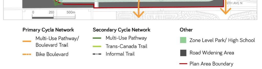
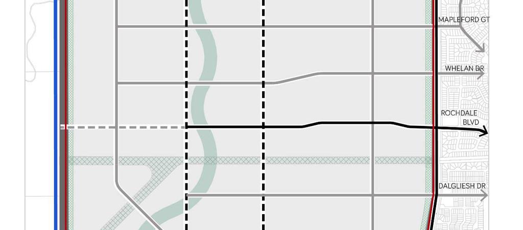
31 Figure 10 Active Transportation Plan Page 29 of 46
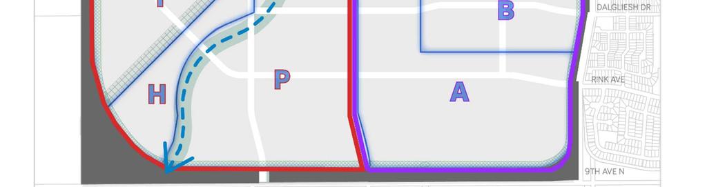
32 Water Servicing Water Servicing Overview The Plan Area straddles two water pressure zones: the Primary Pressure Zone, which supplies the majority of the city, and the North Pressure Zone, which supplies water to the north (see Figure 11). Through a water servicing analysis, which was undertaken in support of this Plan, the following major findings, relating to the provision of water servicing, have been identified: The North Pressure Zone has capacity to accommodate additional development; The Primary Pressure Zone is operating at capacity; any additional development within the Primary Pressure Zone will result in a diminishing level-of-service (e.g. water pressure and fire flow) for existing neighbourhoods especially neighbourhoods in the southeast; Upgrades to the city-wide water system will be required to realize the full build-out of the Coopertown Plan Area. A new city-wide water master plan will be completed by 2018, which will identify servicing solutions for accommodating growth and development. Further analysis of water servicing will be required at the concept plan stage; this analysis must be in conformity with this Plan and any applicable city-wide water master plan Water Servicing Policy a) The location and size of major water lines, as well as pressure zone boundaries, shall be in general accordance with Figure 11 of this Plan; however, the City may permit an alternate network scheme without an amendment to this Plan being required. b) Infrastructure shall be sufficiently sized and include the appropriate stubs to accommodate adjacent development outside of the Plan area, as required by the City. c) Where a concept plan is required, a water servicing report shall be prepared for the subject area, prior to approval of the concept plan, which: i. Establishes a strategy for delivering water service to the concept plan area; ii. Demonstrates how the proposed water distribution network will tie in to the Plan Area system and, where applicable, city-wide system; iii. Outlines the results of a water hydraulic network analysis, complete with the establishment of system demands and network routing, for the concept plan area, as well as for each development stage, where applicable; iv. Demonstrates implications for city-wide water system level-of-service; v. Identifies necessary upgrades, if applicable, to city-wide water systems. Page 30 of 46
33 d) Where the City has a finalized city-wide water master plan that is in effect: i. No concept plan shall be approved unless the proposed concept plan conforms with the applicable city-wide water master plan; ii. The City may require, as a prerequisite for concept plan approval, where applicable, that a water servicing report for the Plan Area be prepared or revised, which is in conformity with the applicable city-wide water master plan. Page 31 of 46


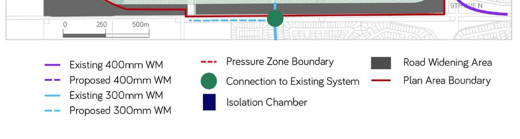
34 Figure 11 Water Servicing Plan Page 32 of 46
35 Wastewater Servicing Wastewater Servicing Overview City-wide wastewater analysis indicates that the collection system, accommodating the neighbourhoods east and south of the Plan Area, as well as the city-wide system generally, would operate at capacity or near capacity during a design storm event. Facilities that are experiencing capacity limitations include: Westhill Lift Station (WHLS); Mapleridge Lift Station (MRLS); Northwest Trunk and the McCarthy Boulevard Pumping Station (MBPS), which is the main collection point for all wastewater flows prior to forcemain discharge to the wastewater treatment plant. Development of the Coopertown Plan Area would overload the existing wastewater system facilities, unless upgrades or the construction of new facilities is undertaken. This Plan recognizes the need for one new wastewater lift/ pump station to accommodate the Coopertown Plan Area. As it is the City s preference that operation efficiency be enhanced by eliminating redundant, inefficient or aging facilities, there is potential to construct a new facility that can replace either, or both, the WHLS and the MRLS. This Plan supports, as a minimum, the decommissioning of the MRLS, as this facility has limited capacity and would require substantial upgrades in order to accommodate additional development and to meet design standards. There are multiple options respecting the location of, and the catchment area for, the proposed new wastewater lift/ pump station. Through the preparation of a city-wide wastewater master plan, which will be completed in 2018, information will be available regarding catchment area options and implications for existing facilities. The new wastewater lift/ pump station will need to be designed to accommodate, initially, or through expansion opportunities, the MRLS catchment area, at a minimum. This facility may discharge directly to the McCarthy forcemains. The City may consider allowing some of the Coopertown wastewater to discharge to the MRLS, as an interim measure; however, it must be demonstrated how additional capacity will be accommodated and how the affected catchment area can tie in to the Coopertown system following the decommissioning of the MRLS. It is the City s preference that all Plan Area development connect to the new Coopertown wastewater lift/ pump station at the outset. Page 33 of 46
36 Wastewater Servicing Policies a) The location of major wastewater infrastructure (e.g. mains and facilities) should be in general accordance with Figure 12 of this Plan; however, the City may permit an alternate network scheme without an amendment to this Plan being required. b) Where a new wastewater lift/ pump facility is required: i. This facility should be strategically located in order to accommodate the largest and/ or most practical gravity-fed catchment area as possible; ii. This facility, including the site area, shall, unless otherwise directed by the City, be sized and designed to accept wastewater flows as a result of the decommissioning of the Westhill and Mapleridge lift stations; iii. This facility, including the site area, shall, if required by the City, be sized and designed to accommodate future expansion (e.g. to accept wastewater flows as a result of intercepting the Northwest Trunk); iv. The force main outlet of the new facility shall be at a point along the McCarthy Boulevard Pumping Station force mains; v. Only one new facility shall be permitted, except where the City, at its discretion, deems that an additional facility may be beneficial. c) The City will only allow the Mapleridge Lift Station (MRLS) to be used to accommodate Coopertown wastewater flows where it can be demonstrated, through the applicable concept plan process: i. That the MRLS can accommodate the expected flows from the proposed development without creating additional issues or failures within the city-wide system (e.g. system surcharging or overload); ii. How the MRLS shall be eventually decommissioned and how the affected area can connect to the Coopertown wastewater system, as shown on Figure 12. d) Notwithstanding Policy 5.3.2(c), at such time as the requisite Coopertown wastewater infrastructure (e.g. main or trunk line) is constructed immediately adjacent to the Mapleridge Lift Station (MRLS): i. The areas utilizing the MRLS shall be required to connect to the Coopertown main/ trunk system by gravity; ii. The MRLS shall be decommissioned and removed and the affected site remediated. Page 34 of 46
37 e) Where the City has a finalized city-wide wastewater master plan that is in effect: i. No concept plan shall be approved unless the proposed concept plan conforms with the applicable city-wide wastewater master plan; ii. The City may require, as a prerequisite for concept plan approval, where applicable, that a wastewater servicing report for the Plan Area be prepared or revised, which is in conformity with the applicable city-wide wastewater master plan. f) Where a concept plan is required, a wastewater servicing report shall be prepared for the subject area, prior to approval of the concept plan, which: i. Establishes a strategy for collecting wastewater within the concept plan area; ii. Demonstrates how the proposed wastewater collection network will connect to the Plan Area system and, where applicable, city-wide system; iii. Outlines the results of a wastewater hydraulic network analysis, complete with the establishment of system flows and network routing for the concept plan area; iv. Demonstrates implications for city-wide wastewater system level-of-service; v. Identifies necessary upgrades, if applicable, to city-wide wastewater systems. Page 35 of 46

38 Figure 12 Wastewater Servicing Plan Page 36 of 46
39 Storm Water Servicing Storm Water Servicing Overview The intent of the storm water strategy is to provide a solution for accommodating the storm water drainage associated with the Plan Area, as well as existing drainage entering the Plan Area from adjacent lands, through two catchment areas. The majority of the Plan Area will be served by a large catchment area ( Catchment Area 1 ) that includes, as the primary feature, a proposed drainage channel. A smaller catchment area ( Catchment Area 2 ), located in the southeast, will discharge storm water to the existing 1200mm storm sewer on Fairway Road. (See Figure 13). The two catchment areas are comprised of sub-catchment areas, as shown on Figure 13. These sub-catchment areas will detain storm water, through ponds or other facilities, before discharging, at a controlled rate, to their respective outlets. Detention may occur, as determined by the City through the concept plan process, within municipal utility parcels or municipal reserve parcels (parks). Potentially, two or more sub-catchment areas can share one detention facility. The proposed drainage channel has the potential to accommodate some of the detention requirements for Catchment Area 1; however, the City would only consider this where a similar hybrid drainage channel (a drainage channel that accommodates both detention and conveyance) has been assessed and accepted. Should the drainage channel accommodate detention, the number and scale of other detention facilities can be lessened; however, the drainage channel, itself, may need to be larger than a conventional system. An illustration showing a potential hybrid drainage channel scheme is included as Appendix 7.2 to this Plan. Although it is expected that all lands within Catchment Area 1 will eventually discharge to the drainage channel, it is recognized that the drainage channel is a major project that may be constructed incrementally over-time. As an interim measure for Phase 1a (see Figure 14), the City may consider a drainage strategy that does not require the drainage channel. Any interim system must be designed so that it can eventually connect to the permanent drainage channel. Further, more detailed, planning for the proposed storm water system shall occur at the concept plan stage. Through the concept plan process, the sub-catchment areas shall be verified (location, area and detention volume), including associated detention facilities and drainage routes. Page 37 of 46
40 Storm Water Servicing Policies a) The location of the drainage channel and the two major catchment areas should be in general accordance with Figure 13 of this Plan. b) The location of storm water detention facilities, and how land will be acquired or dedicated for these facilities, shall be determined through the concept plan process. c) Notwithstanding any other part or policy of this Plan, the City may allow the lands corresponding to Phase 1a, as shown on Figure 14, to be serviced through an interim storm water solution, that does not initially use the drainage channel, as shown on Figure 13, where it can be demonstrated that the proposed interim system: i. Meets the requirements of the City, and any other applicable regulatory authority; ii. Can be decommissioned and can connect to the permanent drainage channel; iii. Will be owned and maintained by the developer, as per the City s Servicing Agreement Fee and Development Levy Policy (as amended). d) The proposed drainage channel, as shown on Figure 13: i. Shall generally be constructed, incrementally, from south to north, and shall be fully constructed as part of the build-out of the 300K lands, as shown on Figure 6. ii. Shall function as an amenity, in addition to a utility system, by including a multi-use pathway and associated landscaping and appurtenances (e.g. lighting, benches, etc.); iii. Shall generally be dedicated as municipal utility parcel; iv. May, at the City s discretion, be used to accommodate some of the storm water detention requirements for the Catchment 1 area lands, as shown on Figure 13. e) As a prerequisite for approval, pertaining to any proposed concept plan that includes the utilization of the drainage channel, as shown on Figure 13, it shall be demonstrated how: i. The drainage channel will be designed (i.e. cross section showing: dimensions, side slopes, benching, access, pathway, conceptual landscaping, etc.); ii. The design, depth and linear slope of the drainage channel will ensure that drainage, into Wascana Creek, can occur, in a design storm event, without creating adverse hydraulic conditions; iii. The drainage channel can be constructed without negatively impacting: sub-surface infrastructure; 9 th Avenue North or 9 th Avenue North/ Bypass interchange; the aquifer; Wascana Creek. Page 38 of 46
41 f) Notwithstanding any other part or policy of this Plan, the City will not allow the proposed drainage channel to accommodate any of the Plan Area storm water detention requirements, unless: i. The has City has determined, through an assessment of a similar hybrid drainage channel (i.e. a facility that accommodates storm water detention and conveyance) within the city (e.g. southeast linear detention facility), or elsewhere, that such a facility performs, or can perform, in a manner that is deemed acceptable to the City; ii. A detailed engineering design and analysis is submitted that demonstrates how the proposed facility can effectively accommodate the detention and conveyance of the storm water associated with a particular drainage catchment area. g) Notwithstanding any other part or policy of this Plan, the City will not approve any concept plan, where the intent is to accommodate some or all of the storm water detention requirements within the drainage channel, as shown on Figure 13, unless the requirements set out in Policy 5.4.2(f) have been met to the City s satisfaction. h) Where a concept plan is required, a storm water servicing report shall be prepared for the subject area, prior to approval of the concept plan, which: i. Establishes a strategy for managing storm water within the concept plan area; ii. Demonstrates how the proposed storm water network will connect to the Plan Area system and, where applicable, city-wide system; iii. Outlines the results of a storm water hydraulic network analysis, including the establishment of system flows and network routing for the concept plan area; iv. Verifies overall detention requirements for the Plan Area, as well as for the applicable concept plan catchment area and sub-catchment areas; v. Identifies implications and, where applicable, upgrades for downstream (beyond Plan Area) storm water facilities; vi. Demonstrates, where applicable, how the proposed storm water system will accommodate existing flows entering the Plan Area. Page 39 of 46


42 Figure 13 Storm Water Servicing Plan Page 40 of 46
43 IMPLEMENTATION Implementation Overview This Plan provides high-level direction for more detailed planning: concept plans, rezoning, subdivision and development. As a prerequisite for rezoning, a concept plan, which illustrates the specific location of land-use types, residential densities, parks and open space and transportation networks, must be prepared for the areas shown on Figure 14. The concept plans must be in conformity with this Plan, and will be appended to this Plan following approval. The phasing of development must be in conformity with the phasing policies and plan of OCP Part A. Implementation Policies a) The phasing of residential development shall be in conformity with the phasing plan and policies of Part A of the Official Community Plan, and the phasing plan of this Plan, as shown on Figure 14. b) An approved concept plan, which substantially conforms with this Plan, shall be required as a prerequisite for rezoning approval, and shall be comprised of the following: i. A land use plan, which illustrates the specific location of different types of streets, land-use, open space and residential densities; ii. A circulation plan, which illustrates the specific location of the proposed street network and classification and, where required by the City: pathways and cycling routes, transit routes, signalized intersections. c) Notwithstanding any other part or policy of this Plan, where a proposed concept plan proposes a utility or transportation scheme that differs from this Plan, the City may approve the concept plan, without an amendment to this Plan being required, where the deviation is considered by the City to be minor or devoid of significant implications. d) Concept plan boundaries should be in conformity with Figure 14; however, the City may allow alternate boundaries without an amendment to this Plan being required. e) Notwithstanding Policy 6.2(a) and (b), the City may allow rezoning and development, without a concept plan being required, and notwithstanding the phasing schedule, to accommodate a public use or utility or transportation infrastructure. Page 41 of 46


44 Figure 14 Phasing & Concept Plan Boundaries Phasing Boundaries Concept Plan Boundaries Page 42 of 46
45 APPENDICES NON-BINDING Environmental Assessment Date Report Location Findings and Recommendations Oct 2010 Feb 2011 Limited NW Regina Lands Phase I ESA Section W2M, NE and SE Section W2M, SE Section W2M and SW and SE Section W2M. Phase I ESA Wellman Estates LSD 11, 12 and 13 Section W2M, SW W2M, SW W2M and Parcel A of Plan No. 89R66653 in Section W2M Potential soil and/or groundwater hydrocarbon contamination from oil and gas transmission lines and past petroleum activity. Recommendation to remove sludge and collect groundwater samples during decommissioning of septic disposal system, and to inspect machinery storage building sites for surface staining prior to development. Jun 2011 Sep 2012 Jul 2013 Dec 2013 Phase II ESA Wellman Estates Parcel A of Section W2M Phase I ESA SE W2 EXT 4, NE W2 EXT 1 and LSD W2 EXT 82 Full and Limited Phase I ESA Portions of Sections 4, 5, 8 & W2M Phase II ESA LSD 14, NW ¼, Sec 4, Twp 18, Rge 20, W2M Phase II investigation required for potential soil and/or groundwater contamination from two former aboveground fuel storage tanks Fuel storage sites investigated. No additional investigation or remedial activity required. Phase II investigation will be required to determine impacts of former fuel storage tanks (potential for hydrocarbon contamination), and impacts of debris in dugout located on the site Phase II investigation required for a dugout containing debris which may have impacted soil and surface water. No surface water present and no soil impacts associated with the debris. Jul 2014 Dec 2014 Phase II ESA SE W2 EXT 4 Phase I ESA SE W2M Removal of debris from dugout recommended with no further investigation required. No evidence of hydrocarbon contamination on subject property. No further investigation necessary Low potential of contamination at the Subject Site and neighbouring properties. No further investigation to quantitatively assess for contamination at the Subject Site is recommended. Page 43 of 46


46 Page 44 of 46


47 Alternative Storm Water Scheme (detention within drainage channel) Page 45 of 46


48 Transit Route Options Page 46 of 46
Complete Neighbourhood Guidelines Review Tool
 Complete Neighbourhood Guidelines Review Tool Prepared By: City of Regina Planning Department October 2014 Page 1 of 14 Community Development Review Checklist for Secondary Plans and Concept Plans The
Outline Plan in Belvedere (Ward 9) at Street SE, LOC (OP)
 at Street SE, LOC (OP)") 2018 October 04 Page 1 of 12 EXECUTIVE SUMMARY This outline plan application was submitted by B&A Planning Group on 2016 July 15, on behalf of Tristar Communities Inc. for 50.14 hectares (123.89 acres)
2018 October 04 Page 1 of 12 EXECUTIVE SUMMARY This outline plan application was submitted by B&A Planning Group on 2016 July 15, on behalf of Tristar Communities Inc. for 50.14 hectares (123.89 acres)
SECTION E. Realizing the Plan
 SECTION E Realizing the Plan 60 DESIGN REGINA - OFFICIAL COMMUNITY PLAN SECTION E Realizing the Plan Design Regina has been an ambitious plan-making exercise, with a high level of community, stakeholder,
City of Grande Prairie Development Services Department
 City of Grande Prairie Development Services Department ROYAL OAKS NORTH OUTLINE PLAN OP-07-03 NW 35-71-6 W6M May 7, 2007 Royal Oaks North Outline Plan TABLE OF CONTENTS 1.0 INTRODUCTION........ 3 1.1 Purpose
LAND USE AMENDMENT CORNERSTONE (WARD 3) 60 STREET NE AND COUNTRY HILLS BOULEVARD NE MAP 26NE BYLAW 22D2017
 60 STREET NE AND COUNTRY HILLS BOULEVARD NE MAP 26NE BYLAW 22D2017") Page 1 of 14 EXECUTIVE SUMMARY This Land Use Amendment application covers an area of 43.76 hectares ± (108.14 acres ±) located in northeast Calgary, bound by Country Hills Boulevard NE to the south and
Page 1 of 14 EXECUTIVE SUMMARY This Land Use Amendment application covers an area of 43.76 hectares ± (108.14 acres ±) located in northeast Calgary, bound by Country Hills Boulevard NE to the south and
OP Council Resolution June 16, Planning and Development Services
 OP-08-01 Council Resolution June 16, 2008 Planning and Development Services Kingsgate Landing Outline Plan Table of Contents 1.0 Introduction 1 1.1 Purpose of Plan 1 1.2 Plan Area Location 1 1.3 Ownership
FORMER CANADIAN FORCES BASE (CFB) ROCKCLIFFE SECONDARY PLAN. Official Plan Amendment XX to the Official Plan for the City of Ottawa
 ROCKCLIFFE SECONDARY PLAN. Official Plan Amendment XX to the Official Plan for the City of Ottawa") FORMER CANADIAN FORCES BASE (CFB) ROCKCLIFFE SECONDARY PLAN Official Plan Amendment XX to the Official Plan for the City of Ottawa 1 INDEX THE STATEMENT OF COMPONENTS PART A THE PREAMBLE PAGE Purpose...
FORMER CANADIAN FORCES BASE (CFB) ROCKCLIFFE SECONDARY PLAN Official Plan Amendment XX to the Official Plan for the City of Ottawa 1 INDEX THE STATEMENT OF COMPONENTS PART A THE PREAMBLE PAGE Purpose...
ADMINISTRATION RECOMMENDATION 2016 November 03. That Calgary Planning Commission recommends APPROVAL of the proposed Land Use Amendment.
 Page 1 of 12 EXECUTIVE SUMMARY This Land Use Amendment application covers an area of 75.76 hectares ± (187.20 acres ±) located in northeast Calgary, bound by Stoney Trail NE to the north, 128 Avenue NE
LAND USE AMENDMENT CORNERSTONE (WARD 3) COUNTRY HILLS BOULEVARD AND STONEY TRAIL NE BYLAW 9D2017
 COUNTRY HILLS BOULEVARD AND STONEY TRAIL NE BYLAW 9D2017") Page 1 of 12 EXECUTIVE SUMMARY This Land Use Amendment application covers an area of 54.92 hectares ± (135.71 acres ±) located in northeast Calgary, bound by Country Hills Boulevard NE to the north and
Page 1 of 12 EXECUTIVE SUMMARY This Land Use Amendment application covers an area of 54.92 hectares ± (135.71 acres ±) located in northeast Calgary, bound by Country Hills Boulevard NE to the north and
S o u t h C e n t r a l O u t l i n e P l a n. Leduc Business Park. North Leduc Industrial Area Structure Plan C it y of Led u c.
 Leduc Business Park North Leduc Industrial Area Structure Plan C it y of Led u c Prepared for Farm Air Properties Inc. January, 2007 Table of Contents Page Number 1.0 Purpose of Plan and Definition of
THE CITY OF WINNIPEG BY-LAW NO. 4/2013. A By-law of THE CITY OF WINNIPEG to adopt a Secondary Plan for the Waverley West Southwest Neighbourhood.
 THE CITY OF WINNIPEG BY-LAW NO. 4/2013 A By-law of THE CITY OF WINNIPEG to adopt a Secondary Plan for the Waverley West Southwest Neighbourhood. THE CITY OF WINNIPEG, in Council assembled, enacts as follows:
PORT WHITBY COMMUNITY
 PORT WHITBY COMMUNITY SECONDARY PLAN UPDATE COMMUNITY IMPROVEMENT PLAN URBAN DESIGN GUIDELINES September 2015 DRAFT PROPOSED AMENDMENT NUMBER # to the Whitby Official Plan PURPOSE: The intent of this Amendment
Gold Line Bus Rapid Transit Transit Oriented Development (BRTOD) Helmo Station Area Plan
 Helmo Station Area Plan") Appendix F Gold Line Bus Rapid Transit Transit Oriented Development (BRTOD) Helmo Station Area Plan Introduction and Purpose of the Plan The Gold Line Bus Rapid Transit facility is an eleven-mile dedicated
Appendix F Gold Line Bus Rapid Transit Transit Oriented Development (BRTOD) Helmo Station Area Plan Introduction and Purpose of the Plan The Gold Line Bus Rapid Transit facility is an eleven-mile dedicated
ARTICLE 6: Special and Planned Development Districts
 ARTICLE 6: Special and Planned Development Districts 6-10 Traditional Neighborhood Development (TND) District 6-10.10 Purpose and Intent The Traditional Neighborhood Development (TND) District provides
ELMVALE ACRES SHOPPING CENTRE MASTER PLAN
 ELMVALE ACRES SHOPPING CENTRE MASTER PLAN Contents 1.0 INTRODUCTION... 2 2.0 LOCATION... 2 3.0 EXISTING CONTEXT... 2 4.0 VISION & GUIDING PRINCIPLES... 2 5.0 LAND USE AND BUILT FORM... 4 5.1 St. Laurent
City of Grande Prairie Development Services Department KENNEDY DEVELOPMENTS LTD. OUTLINE PLAN OP-09-01
 City of Grande Prairie Development Services Department KENNEDY DEVELOPMENTS LTD. OUTLINE PLAN OP-09-01 July 27, 2009 TABLE OF CONTENTS 1.0 Introduction... 1 1.1 Plan Area Location & Context... 1 1.2 Ownership
URBAN DESIGN BRIEF. 2136&2148 Trafalgar Road. Town of Oakville
 URBAN DESIGN BRIEF 2136&2148 Trafalgar Road Town of Oakville Prepared By: METROPOLITAN CONSULTING INC For 2500674 Ontario Inc November 2016 TABLE OF CONTENTS Page No. 1.0 Introduction/Description of Subject
WEST HILL BUSINESS PARK AREA STRUCTURE PLAN
 MUNICIPAL DISTRICT OF PEACE NO. 135 WEST HILL BUSINESS PARK AREA STRUCTURE PLAN Prepared by: TABLE OF CONTENTS 1.0 Introduction... 1 1.1 Purpose of Plan........ 1 1.2 Plan Area..... 1 1.3 Existing Conditions...
and services The protection and conservation of environmentally significant and sensitive natural heritage features and functions.
 6. Land Use 6.0 Preamble A healthy and livable city is one in which people can enjoy a vibrant economy and a sustainable healthy environment in safe, caring and diverse neighbourhoods. In order to ensure
HURON COMMUNITY PLAN
 CITY OF KITCHENER DEPARTMENT OF DEVELOPMENT AND TECHNICAL SERVICES PD 94/7 HURON COMMUNITY PLAN Recommended by Planning and Economic Development Committee: October 31, 1994 Adopted by Kitchener City Council:
The transportation system in a community is an
 7 TRANSPORTATION The transportation system in a community is an important factor contributing to the quality of life of the residents. Without a sound transportation system to bring both goods and patrons
Westwind Developments Ltd. PIONEER LANDS AREA STRUCTURE PLAN - PROPOSED AMENDMENT
 FEBRUARY 2013 TABLE OF CONTENTS 1.0 BACKGROUND... 1 1.1 Amendment... 1 2.0 LOCATION & CONTEXT... 2 2.1 Land Ownership... 2 3.0 POLICY CONTEXT... 3 3.1 Municipal Development Plan... 3 3.2 Capital Region
Land Use Amendment in Southwood (Ward 11) at and Elbow Drive SW, LOC
 at and Elbow Drive SW, LOC") 2018 November 15 Page 1 of 10 EXECUTIVE SUMMARY This land use amendment application was submitted by Rick Balbi Architect on 2017 August 31 on behalf of Sable Developments Ltd, and with authorization from
2018 November 15 Page 1 of 10 EXECUTIVE SUMMARY This land use amendment application was submitted by Rick Balbi Architect on 2017 August 31 on behalf of Sable Developments Ltd, and with authorization from
Ten Mile Creek Planning Area
 PLANNING AREA POLICIES TEN MILE CREEK Ten Mile Creek Planning Area Location and Context The Ten Mile Creek Planning Area ( Ten Mile Creek area ) is located south of the current Boise AOCI, generally south
I615. Westgate Precinct
 I615. Westgate Precinct I615.1. Precinct Description The Westgate Precinct is located approximately 18km west of the Auckland city centre. There are seven Sub-precincts in the Westgate Precinct: Sub-precinct
The West Vaughan Employment Area Secondary Plan Policies
 Part 2: The West Vaughan Employment Area Secondary Plan Policies 2.1 General Policies It is the policy of Council: 2.1.1. That the West Vaughan Employment Area (the WVEA), identified on Schedule 1, will
1.0 Purpose of a Secondary Plan for the Masonville Transit Village
 Report to Planning and Environment Committee To: Chair and Members Planning & Environment Committee From: John M. Fleming Managing Director, Planning and City Planner Subject: Masonville Transit Village
Staff Report and Recommendation
 Community Planning and Development Planning Services 201 W. Colfax Ave., Dept. 205 Denver, CO 80202 p: 720.865.2915 f: 720.865.3052 www.denvergov.org/cpd TO: City Council Neighborhoods and Planning Committee
North Oakville East Parks Facilities Distribution Plan. November, 2009
 North Oakville East November, 2009 POLICY CONTEXT 1) Purpose a) The purpose of this document is to be a guide for the location, configuration, design and development of the parks system for the North Oakville
Urban Design Brief December 23, 2015 Southside Construction Group Official Plan & Zoning By-Law Amendment
 Urban Design Brief Proposed Official Plan & Zoning By-Law Amendment 3244, 3263 and 3274 Wonderland Road South Southside Group December 23, 2015 TABLE OF CONTENTS Page No. INTRODUCTION... 1 SECTION 1 LAND
5.0 Community Design Plan
 5.0 Community Design Plan The Community Design Plan for the Mer Bleue area is a composite of three plans: Land Use Plan Transportation Plan Municipal Servicing Plan Read together, these Plans and associated
DAVENPORT VILLAGE SECONDARY PLAN
 27 DAVENPORT VILLAGE SECONDARY PLAN 27. DAVENPORT VILLAGE SECONDARY PLAN 1. VISION FOR THE DAVENPORT VILLAGE SECONDARY PLAN Davenport Village, municipally known as 830, 940, 980 and 1100 Lansdowne Avenue,
Bylaw C-1186 Adopted November 5, Planning and Development Services
 Bylaw C-1186 Adopted November 5, 2007 Planning and Development Services CITY OF GRANDE PRAIRIE OFFICE CONSOLIDATION BYLAW C-1186 A Bylaw to adopt the Westgate Area Structure Plan (As Amended by Bylaw C-1186-1,
Bylaw No. B-03/2011 Adopted by Airdrie City Council February 21, 2012
 COOPER S CROSSING STAGE 4 Neighbourhood Structure Plan City of Airdrie WESTMARK HOLDINGS LTD. Bylaw No. B-03/2011 Adopted by Airdrie City Council February 21, 2012 CONSULTANTS: LAND USE PLANNING: Southwell
LAND USE AMENDMENT DOWNTOWN COMMERCIAL CORE (WARD 7) MACLEOD TRAIL SE AND 5 AVENUE SE BYLAW 254D2017
 MACLEOD TRAIL SE AND 5 AVENUE SE BYLAW 254D2017") Page 1 of 10 EXECUTIVE SUMMARY This Land Use Amendment application seeks to redesignate a full downtown block (currently the YWCA site) from a Direct Control based on the CM-2 District (Land Use Bylaw
Page 1 of 10 EXECUTIVE SUMMARY This Land Use Amendment application seeks to redesignate a full downtown block (currently the YWCA site) from a Direct Control based on the CM-2 District (Land Use Bylaw
THE GARDEN CITY PLAN. City of St. Catharines Official Plan. City of St. Catharines
 THE GARDEN CITY PLAN City of St. Catharines Official Plan City of St. Catharines August 2010 APPROVAL INFORMATION This Official Plan of the City of St. Catharines Planning Area, known as the Garden City
Derry Green Corporate Business Park
 Town of Milton Derry Green Corporate Business Park Urban Design Guidelines BMI/Pace - June 2010 Draft 3 Prepared by: Brook McIlroy Planning + Urban Design / Pace Architects Suite 300-51 Camden Street Toronto,
URBAN DESIGN BRIEF URBAN DESIGN BRIEF 721 FRANKLIN BLVD, CAMBRIDGE August 2018
 URBAN DESIGN BRIEF URBAN DESIGN BRIEF 721 FRANKLIN BLVD, CAMBRIDGE August 2018 DESIGN BRIEF CONTENTS PART A 1.0 INTRODUCTION 2.0 DESCRIPTION & ANALYSIS OF SITE CONTEXT 3.0 DESIGN CONSTRAINTS AND OPPORTUNITIES
4780 Eglinton Avenue West - Zoning By-law Amendment and Draft Plan of Subdivision Applications - Preliminary Report
 STAFF REPORT ACTION REQUIRED 4780 Eglinton Avenue West - Zoning By-law Amendment and Draft Plan of Subdivision Applications - Preliminary Report Date: May 29, 2014 To: From: Wards: Reference Number: Etobicoke
Auburn Bay Community Plan
 Auburn Bay Community Plan Auburn Bay Community Plan Office Consolidation June 2007 Bylaw 15P2003 Approved January 19, 2004 Note: This office consolidation includes the following amending Bylaws: Amendment
THE CITY OF WINNIPEG BY-LAW NO. 48/2014
 THE CITY OF WINNIPEG BY-LAW NO. 48/2014 A By-law of THE CITY OF WINNIPEG to adopt a secondary plan for Precinct K of the Complete Communities Direction Strategy By-law No. 68/2010. THE CITY OF WINNIPEG,
CONTENTS 8.0 LAND USE 8.1 GENERAL LAND USE 8.2 RESIDENTIAL 8.3 MIXED USE 8.4 COMMERCIAL 8.5 EMPLOYMENT LANDS
 8-2 Land Use 8.0 LAND USE CONTENTS 8.1 GENERAL LAND USE 8.1.1 Uses provided for in all Land Use Designations 8.1.2 Uses prohibited in Hazardous Lands, Hazardous Sites and Special Policy Areas 8.1.3 Uses
Description of Preferred Alternative
 Chapter 2 Description of Preferred Alternative 2.1 Introduction This chapter of the programmatic Sammamish Town Center Sub-area Plan Final EIS provides a more detailed description of the Preferred Alternative
Bylaw C-1262 Adopted February 6, Planning and Development Department
 Bylaw C-1262 Adopted February 6, 2012 Planning and Development Department CITY OF GRANDE PRAIRIE BYLAW C-1262 A Bylaw to adopt the Brookfield Neighbourhood Outline Plan THE MUNICIPAL COUNCIL OF THE CITY
Brampton. Secondary Plan. Review. Bram West. A New Direction in Planning & Public Consultation
 Brampton Bram West Secondary Plan Review A New Direction in Planning & Public Consultation Introduction The Bram West Secondary Plan Review offers an important opportunity for the community to define a
ADMINISTRATION RECOMMENDATION(S) 2017 February 09. That Calgary Planning Commission recommends APPROVAL of the proposed Land Use Amendment.
 2017 February 09. That Calgary Planning Commission recommends APPROVAL of the proposed Land Use Amendment.") Page 1 of 10 EXECUTIVE SUMMARY This land use amendment application is to accommodate changes to the location of a stormwater retention pond and land use boundaries adjacent to Environmental Reserve in
Page 1 of 10 EXECUTIVE SUMMARY This land use amendment application is to accommodate changes to the location of a stormwater retention pond and land use boundaries adjacent to Environmental Reserve in
5.1 Site Plan Guidelines
 5. Community Core Guidelines Development of the Community Core will take place by plan of subdivision and site plan approval. It will occur in a phased manner that will reflect the timing of residential
Phase 1 Concept Plan MAY 26, Version Circulation Draft
 Phase 1 Concept Plan MAY 26, 2014 Version 2.0 - Circulation Draft Project Team: Project Engineers WSP/Genivar Contact: Jeff Halliday 306.585.1990 Phase 1 Concept Plan May 2014 Prepared for: Westerra Development
Leduc Industrial Outline Plan SE W4
 Leduc Industrial Outline Plan SE 1-50-25-W4 Within the North Leduc Industrial ASP Prepared for: Leduc Energy Park Ltd. Prepared by: Stantec Consulting Ltd. File No. 1161 104655 V5 Table of Contents 1.0
9 CITY OF VAUGHAN OFFICIAL PLAN AMENDMENT NO BOCA EAST INVESTMENTS LIMITED
 9 CITY OF VAUGHAN OFFICIAL PLAN AMENDMENT NO. 631 - BOCA EAST INVESTMENTS LIMITED The Planning and Economic Development Committee recommends the adoption of the recommendations contained in the following
ROAD CLOSURE AND LAND USE AMENDMENT SILVER SPRINGS (WARD 1) NORTHEAST OF NOSEHILL DRIVE NW AND SILVER SPRINGS ROAD NW BYLAWS 2C2018 AND 29D2018
 NORTHEAST OF NOSEHILL DRIVE NW AND SILVER SPRINGS ROAD NW BYLAWS 2C2018 AND 29D2018") Page 1 of 19 EXECUTIVE SUMMARY This application proposes redesignating two parcels in the community of Silver Springs from Special Purpose Future Urban Development (S-FUD) District and undesignated road
Page 1 of 19 EXECUTIVE SUMMARY This application proposes redesignating two parcels in the community of Silver Springs from Special Purpose Future Urban Development (S-FUD) District and undesignated road
URBAN DESIGN BRIEF 305, 309, & 315 SOUTHDALE ROAD WEST LONDON ONTARIO
 URBAN DESIGN BRIEF 305, 309, & 315 SOUTHDALE ROAD WEST LONDON ONTARIO CARVEST PROPERTIES LTD. December 2013 Section 1 - Land Use Planning Context 1.1 Subject Lands The subject lands are located immediately
This application has been applied for with support of an Outline Plan to provide the technical details for the site s development.
 Page 1 of 13 EXECUTIVE SUMMARY This application consists of a Land Use Amendment application proposing redesignation from Special Purpose Future Urban Development (S-FUD) District to an assortment of multiresidential,
C ity of Grande Prairie Development Services Department
 C ity of Grande Prairie Development Services Department FAIRWAY DEVELOPMENT OUTLINE PLAN OP 08 09 Approved April 6, 2009 Prepared by: Focus Corporation Table of Contents 1.0. Introduction 2 3 1.1. Plan
Sustainable Growth. Sustainable Growth
 2 Sustainable Growth Sustainable Growth SUSTAINABLE GROWTH 2.1 COMMUNITY VISION... 2-5 2.2 THE CITY SYSTEM... 2-7 2.2.1 AREAS... 2-7 2.2.2 CITY-WIDE SYSTEMS... 2-8 2.2.3 PROVINCIAL PLAN BOUNDARIES AND
11.4 Highway 400 North Employment Lands Secondary Plan APPROVED BY THE ONTARIO MUNICIPAL BOARD ON NOVEMBER 21, 2011
 11.4 Highway 400 North Employment Lands Secondary Plan APPROVED BY THE ONTARIO MUNICIPAL BOARD ON NOVEMBER 21, 2011 11.4.1 General 11.4.1.1. as approved by the Ontario Municipal Board on November 21, 2011,
THE CITY OF WINNIPEG BY-LAW NO. 97/2014
 THE CITY OF WINNIPEG BY-LAW NO. 97/2014 A By-law of THE CITY OF WINNIPEG to adopt a secondary plan for Precinct E of the Complete Communities Direction Strategy By-law No. 68/2010. THE CITY OF WINNIPEG,
Providence. Area Structure Plan
 Providence Area Structure Plan PUBLISHING INFORMATION Title: Author: Status: Printing Date: Additional Copies: Providence Area Structure Plan Local Area Planning and Implementation Planning, Development
Municipal Development Plan Update Urban Service Area and Hamlets
 ENCLOSURE 1 Municipal Development Plan Update Urban Service Area and Hamlets Priorities Committee January 24, 2017 MUNICIPAL DEVELOPMENT PLAN UPDATE SHAPING OUR FUTURE MDP Update - Agenda MDP Update Public
AWH REPORT OF THE PLANNING AND DEVELOPMENT DEPARTMENT FOR APPLICATION FOR REZONING ORDINANCE TO PLANNED UNIT DEVELOPMENT
 AWH REPORT OF THE PLANNING AND DEVELOPMENT DEPARTMENT FOR APPLICATION FOR REZONING ORDINANCE TO PLANNED UNIT DEVELOPMENT MAY 8, 2014 The Planning and Development Department hereby forwards to the Planning
DRAFT Northeast Quadrant of Kipling Avenue and Highway 7 DRAFT AUGUST 29, Goals Land Use. The goals of this Plan are to:
 AUGUST 29, 2017 12.15 Northeast Quadrant of Kipling Avenue and Highway 7 12.15.1 Goals 12.15.2 Land Use The goals of this Plan are to: 12.15.2.1 General Provisions: a) Ensure the development of a compact
6 Growth Management Challenges and Opportunities
 6 Growth Management Challenges and Opportunities The Town has established a goal of attaining a 50% participation rate with respect to employment opportunities versus residential population. The Town s
5. Spring Garden Planning Area (Secondary Plan added by OPA #05 11/29/2002)
") 5. Spring Garden Planning Area (Secondary Plan added by OPA #05 11/29/2002) 5.0 Preamble THE PLANNING AREA FRAGMENTED OWNERSHIP PATTERN EMERGING LAND USE ISSUES IMPLEMENT STUDY FINDINGS The Spring Garden
5. Spring Garden Planning Area (Secondary Plan added by OPA #05 11/29/2002) 5.0 Preamble THE PLANNING AREA FRAGMENTED OWNERSHIP PATTERN EMERGING LAND USE ISSUES IMPLEMENT STUDY FINDINGS The Spring Garden
Report to: Development Services Committee Report Date: September 11, 2017
 ~RKHAM Report to: Development Services Committee Report Date: September 11, 2017 SUBJECT: PREPARED BY: Conceptual Master Plan for the Future Urban Area - Community Structure Plan and Key Policy Direction
BYLAW C A Bylaw of Rocky View County to amend Land Use Bylaw C
 BYLAW C-7720-2017 A Bylaw of Rocky View County to amend Land Use Bylaw C-4841-97. The Council of Rocky View County enacts as follows: PART 1 TITLE This Bylaw shall be known as Bylaw C-7720-2017. PART 2
SECTION D. Citywide Policies
 SECTION D Citywide Policies 24 25 PART A - CITYWIDE PLAN - CITYWIDE POLICIES SECTION D Citywide Policies THIS SECTION PROVIDES POLICY DIRECTION BY TOPIC AREA: D1: Regional Context D2: Environment D3: Transportation
Palisades Outline Plan
 NE ¼ 25 36 28 W4 Town of Penhold Approved August 13, 2012 Contents Figures & Tables... 2 Introduction... 1 Overview... 1 Purpose... 1 Development Area... 3 Ownership... 3 Topography... 3 Existing & Surrounding
COMMUNITY DESIGN. GOAL: Create livable and attractive communities. Intent
 COMMUNITY DESIGN Intent An attractive, well-designed County will attract quality development, instill civic pride, improve the visual character of the community, and create a strong, positive image for
Bressa Developments Limited. Planning Justification Report. Revised Draft Plan of Subdivision and Zoning By-Law Amendment
 Bressa Developments Limited Revised Draft Plan of Subdivision and Zoning By-Law Amendment Planning Justification Report Part of Lots 7 & 8 Concession 1, North of Dundas Street Town of Oakville September,
South Macleod Centre. Area Structure Plan
 South Macleod Centre Area Structure Plan 58P2017 September 2017 Publishing information Title South Macleod Centre Area Structure Plan Author The City of Calgary Status Approved by City Council Bylaw 58P2017
4.1.3 LAND USE CATEGORIES
 4.1.3 LAND USE CATEGORIES a. City Center District The City Center District incorporates the existing character and mix of uses in downtown Belmont to encourage redevelopment and new development in keeping
I539. Smales 2 Precinct
 I539. Smales 2 Precinct I539.1. Precinct Description The Smales 2 Precinct applies to a 4.8 hectare block of land located on the southern side of Northcote Road and fronting Lake Pupuke, Takapuna. The
New-Cast Mixed-use Development Proposal King Street West, Newcastle, Ontario
 URBAN DESIGN BRIEF New-Cast Mixed-use Development Proposal King Street West, Newcastle, Ontario TABLE OF CONTENTS: 1.0 Executive Summary 2.0 Creating Vibrant and Sustainable Urban Places: Excerpts from
Attachment 1 TOWN OF NEW TECUMSETH. Manual for the Preparation of an Urban Design Report
 Attachment 1 TOWN OF NEW TECUMSETH Manual for the Preparation of an Urban Design Report July 2010 TABLE OF CONTENTS Background, Policy Framework and the Preparation of Urban Design Reports 1. Introduction
11.4 Highway 400 North Employment Lands Secondary Plan
 11.4 Highway 400 North Employment Lands Secondary Plan APPROVED BY THE ONTARIO MUNICIPAL BOARD ON NOVEMBER 21, 2011 11.4.1 General 11.4.1.1. The following policies and Schedules A - I form Official Plan
Regency Developments. Urban Design Brief. Holyrood DC2 Rezoning
 Regency Developments Urban Design Brief Holyrood DC2 Rezoning Stantec Consulting Ltd. 7-31-2017 1. Overview Regency Developments intends to rezone the lands located at 8510 and 8511 93 Avenue, within the
Commercial Development Proposal Tenth Line Road. Planning Rationale Report. Minto Developments Inc.
 Commercial Development Proposal 2168 Tenth Line Road Report September 2015 Prepared for Minto Developments Inc. Paquette Planning Associates Ltd. 56 Hutchison Avenue Ottawa, Ontario K1Y 4A3 PH: 613-722-7217
Town of Portola Valley General Plan. Nathhorst Triangle Area Plan
 Town of Portola Valley General Plan Amended December 10, 1997 Table of Contents Introduction... 1 Planning Area... 1 Objectives... 2 Principles... 2 Standards... 4 Description... 4 Community Commercial...
OFFICE CONSOLIDATION SECONDARY PLAN AREA 22 THE BRAMALEA SOUTH INDUSTRIAL SECONDARY PLAN
 OFFICE CONSOLIDATION SECONDARY PLAN AREA 22 THE BRAMALEA SOUTH INDUSTRIAL SECONDARY PLAN November 2010 EXPLANATORY NOTES (Secondary Plan Area 22) General (pertaining to all secondary plan office consolidations)
The Uplands Area Structure Plan. City of Cold Lake, NE & SE W4
 City of Cold Lake, NE & SE 13-63-2-W4 July 2009 1 Contents 1 Background information... 1 1.1 Foreword... 1 1.2 Purpose... 1 1.3 Plan Area and Location... 1 1.4 Ownership... 2 2 Factors Influencing Development...
Former Rockcliffe Airbase Community Design Plan Guiding Design Vision and Principles December 4, 2013
 APPENDIX 5 - Guiding Design Vision and Principles Former Rockcliffe Airbase Community Design Plan Guiding Design Vision and Principles December 4, 2013 Vision Statement The redevelopment of the former
SYRINGA VALLEY SPECIFIC PLAN NARRATIVE
 SYRINGA VALLEY SPECIFIC PLAN NARRATIVE Introduction With this application, Pleasant Valley South LLC ( Pleasant Valley ) seeks the City of Boise s approval of a new Specific Plan Ordinance to be added
The Corporation of the TOWN OF MILTON
 Report to: From: Chair & Members of the Administration & Planning Standing Committee W.F. Mann, Director of Planning and Development Date: April 16, 2012 PD 022-12 (Z19/11) Subject: Technical Report Proposed
SECTION ONE: INTRODUCTION. introduction
 introduction 1 INTRODUCTION Since it was first established in 1843 as a trading post for the Hudson s Bay Company, Victoria has evolved into a Provincial capital city that is recognized across Canada and
POLICY AMENDMENT AND LAND USE AMENDMENT KILLARNEY/GLENGARRY (WARD 8) NW CORNER OF RICHMOND ROAD AND 33 STREET SW BYLAWS 1P2015 AND 7D2015
 NW CORNER OF RICHMOND ROAD AND 33 STREET SW BYLAWS 1P2015 AND 7D2015") Page 1 of 13 EXECUTIVE SUMMARY This application seeks to redesignate an RC-2 (Residential Contextual One/Two Dwelling) parcel to MC-Gd72 (Multi-Residential Contextual Grade-Oriented) to allow for multi-residential
Page 1 of 13 EXECUTIVE SUMMARY This application seeks to redesignate an RC-2 (Residential Contextual One/Two Dwelling) parcel to MC-Gd72 (Multi-Residential Contextual Grade-Oriented) to allow for multi-residential
Official Plan Review
 Official Plan Review Summary Report - The Built Environment August 2014 Part 1: Introduction Planning for a healthy, prosperous and sustainable community is an important goal for our municipality. From
[PLANNING RATIONALE] For Site Plan Control and Lifting of Holding Zone By-Law 101 Champagne Avenue. May 23, 2014
![[PLANNING RATIONALE] For Site Plan Control and Lifting of Holding Zone By-Law 101 Champagne Avenue. May 23, 2014](/thumbs/75/71599615.jpg "[PLANNING RATIONALE] For Site Plan Control and Lifting of Holding Zone By-Law 101 Champagne Avenue. May 23, 2014") [PLANNING RATIONALE] For Site Plan Control and Lifting of Holding Zone By-Law 101 Champagne Avenue May 23, 2014 Contents 1.0 Introduction... 2 2.0 Site Context... 2 2.1 Adjacent Uses... 2 Figure 1: Site
[PLANNING RATIONALE] For Site Plan Control and Lifting of Holding Zone By-Law 101 Champagne Avenue May 23, 2014 Contents 1.0 Introduction... 2 2.0 Site Context... 2 2.1 Adjacent Uses... 2 Figure 1: Site
Master Site Development Plan (MSDP) Rocky View County Campus at Balzac East
 Rocky View County Campus at Balzac East") Master Site Development Plan (MSDP) Rocky View County Campus at Balzac East Balzac East, Alberta July 2009 CONTENTS 1.0 purpose 1 2.0 guiding principles 2 3.0 site description 3 4.0 site analysis and county
Master Site Development Plan (MSDP) Rocky View County Campus at Balzac East Balzac East, Alberta July 2009 CONTENTS 1.0 purpose 1 2.0 guiding principles 2 3.0 site description 3 4.0 site analysis and county
13 THORNHILL YONGE STREET STUDY IMPLEMENTATION CITY OF VAUGHAN OPA 669 AND TOWN OF MARKHAM OPA 154
 13 THORNHILL YONGE STREET STUDY IMPLEMENTATION CITY OF VAUGHAN OPA 669 AND TOWN OF MARKHAM OPA 154 The Planning and Economic Development Committee recommends the adoption of the recommendations contained
YONGE STEELES CORRIDOR SECONDARY PLAN. Young + Wright / IBI Group Architects Dillon Consulting Ltd. GHK International (Canada) Ltd.
 Ltd.") PART A: PREAMBLE 1.0 PURPOSE The purpose of this Secondary Plan is to provide a development framework for intensification of the Yonge/ Steeles corridor including the north side of Steeles Avenue West
PART A: PREAMBLE 1.0 PURPOSE The purpose of this Secondary Plan is to provide a development framework for intensification of the Yonge/ Steeles corridor including the north side of Steeles Avenue West
AREASTRUCTURE PLAN AMENDMENT COCHRANE NORTH
 AREASTRUCTURE PLAN AMENDMENT COCHRANE NORTH In order to implement the vision outlined in the Conceptual Scheme, the following three amendments to the Cochrane North ASP are proposed: 1. Allow commercial
Community Design Guidelines. Port Wallace DRAFT
 Community Design Guidelines Port Wallace DRAFT Energy 1 2 3 Nature Movement Connections Built Form DRAFT Layout Energy 1 Nature Community Design Guidelines GREAT COMMUNITIES PROTECT, CELEBRATE, AND CONSERVE
KANATA CENTRUM 255 KANATA AVENUE OFFICIAL PLAN AMENDMENT ZONING BY-LAW AMENDMENT
 KANATA CENTRUM 255 KANATA AVENUE OFFICIAL PLAN AMENDMENT ZONING BY-LAW AMENDMENT JUNE 2015 PREPARED BY: FOTENN Consultants Inc. 223 Mcleod Street Ottawa, ON K2P OZ8 (613) 730-5709 PREPARED FOR: Kanata
THE NEW COMMUNITY PLANNING GUIDEBOOK
 MUNICIPAL DEVELOPMENT PLAN: VOLUME 2, PART 1 THE NEW COMMUNITY PLANNING GUIDEBOOK Adopted by Council [Approval Date] calgary.ca contact 311 Onward/ We will create great communities with quality living
PLANNING COMMITTEE REPORT JULY COMITÉ DE L URBANISME RAPPORT 34 LE 11 JUILLET ZONING 968 ST.
 86 COMITÉ DE L URBANISME 6. ZONING 968 ST. LAURENT BOULEVARD ZONAGE 968, BOULEVARD ST-LAURENT COMMITTEE RECOMMENDATION That Council approve an amendment to the Zoning By-law 2008-250 to change the zoning
AMENDMENT NO. 30 TO THE OFFICIAL PLAN OF THE TOWN OF MILTON
 AMENDMENT NO. 30 TO THE OFFICIAL PLAN OF THE TOWN OF MILTON Subject: Boyne Survey Secondary Plan and Related Official Plan Amendments The following text and schedules constitute Amendment No. 30 to the
GATEWAY AREA STRUCTURE PLAN
 CHESTERMERE GATEWAY AREA STRUCTURE PLAN COMMUNITY OPEN HOUSE SEPTEMBER 22 nd, 2015 PLAN AREA ± 512 hectares (± 1,265 acres) GATEWAY LOCATION UNDEVELOPED LANDS PRESENT AGRICULTURAL USE REGIONAL LAND USE
Hockessin Community Redevelopment Plan
 Hockessin Community Redevelopment Plan 3.1 Introduction The Community Redevelopment Plan for the Village of Hockessin is the result of the people s vision for a distinct village center that serves as the
Table 8-4: Road Classification Local Roads, second table, of Chapter 8 Create a Multi-Modal City, be amended by adding the following:
 1 Port Street East Official Plan Amendment APPENDIX 3 Amendments to Mississauga Official Plan Table 8-4: Road Classification Local Roads, second table, of Chapter 8 Create a Multi-Modal City, be amended
Urban Design Manual PLANNING AROUND RAPID TRANSIT STATIONS (PARTS) Introduction. Station Study Areas
 Introduction. Station Study Areas") 111111 PLANNING AROUND RAPID TRANSIT STATIONS (PARTS) Introduction The ION rapid transit system will link Waterloo, Kitchener and Cambridge through a central transit corridor (CTC). There are a number
111111 PLANNING AROUND RAPID TRANSIT STATIONS (PARTS) Introduction The ION rapid transit system will link Waterloo, Kitchener and Cambridge through a central transit corridor (CTC). There are a number