This application has been applied for with support of an Outline Plan to provide the technical details for the site s development.
|
|
|
- Alberta Edwards
- 5 years ago
- Views:
Transcription
1 Page 1 of 13 EXECUTIVE SUMMARY This application consists of a Land Use Amendment application proposing redesignation from Special Purpose Future Urban Development (S-FUD) District to an assortment of multiresidential, commercial and special purpose districts. This application has been applied for with support of an Outline Plan to provide the technical details for the site s development. PREVIOUS COUNCIL DIRECTION None. ADMINISTRATION RECOMMENDATION(S) 2015 September 24 That Calgary Planning Commission recommends APPROVE of the proposed Land Use Amendment. RECOMMENDATION(S) OF THE CALGARY PLANNING COMMISSION That Council hold a Public Hearing on Bylaw 187D2015; and 1. ADOPT the proposed redesignation of hectares ± (37.44 acres ±) located at Street NE (Portion of NW 1/4 Section ) from Special Purpose Future Urban Development (S-FUD) District to Multi-Residential Low Profile (M-1d62) District, Multi-Residential Medium Profile (M-2d124) District, Multi-Residential Medium Profile Support Commercial (M-X2d111) District, Multi-Residential Medium Profile Support Commercial (M-X2d185) District, Multi-Residential Low Profile Support Commercial (M-X1d100) District, Commercial Corridor 2 f1.0h26, (C-COR2 f1.0h26) District, Commercial Corridor 2 f2.5h26 (C-COR2 f2.5h26) District, Special Purpose City and Regional Infrastructure (S-CRI) District, in accordance with Administration s recommendation; and 2. Give three readings to the proposed Bylaw 187D2015.
2 Page 2 of 13 REASON(S) FOR RECOMMENDATION: The proposed Land Use Amendment achieves the MDP objectives related to integrating land use districts, community infrastructure, and supportive uses within a Community Activity Centre. This application and supporting Outline Plan provide the land uses and technical framework needed to achieve the development vision of the Community Activity Centre, proposes a grid based, well connected, complete street pattern in the subdivision design; it provides additional pedestrian linkages to create strong walkability, and it meets minimum intensity and density targets. ATTACHMENT 1. Proposed Bylaw 187D2015


3 CALGARY PLANNING COMMISSION Page 3 of 13 LOCATION MAPS
4 Page 4 of 13 ADMINISTRATIONS RECOMMENDATION TO CALGARY PLANNING COMMISSION Recommend that Council ADOPT, by bylaw, the proposed redesignation of hectares ± (37.44 acres ±) located at Street NE (Portion of NW 1/4 Section ) from Special Purpose Future Urban Development (S-FUD) District to Multi-Residential Low Profile (M-1d62) District, Multi-Residential Medium Profile (M-2d124) District, Multi-Residential Medium Profile Support Commercial (M-X2d111) District, Multi-Residential Medium Profile Support Commercial (M-X2d185) District, Multi-Residential Low Profile Support Commercial (M-X1d100) District, Commercial Corridor 2 f1.0h26, (C-COR2 f1.0h26) District, Commercial Corridor 2 f2.5h26 (C-COR2 f2.5h26) District, Special Purpose City and Regional Infrastructure (S-CRI) District. Moved by: J. Gondek Carried: 6 1 Opposed: G.-C. Carra Reasons for support of Adoption recommendation from Ms. Wade: Private road allows to enhancement to the public realm with street furniture and plantings, and costs are born by the private land owners versus paying additional funds to City to secure removal if requires and limited to budgets. S-CRI sites were selected be Transit on the internal review process and the Applicant has worked with Administration on location. The design has not yet been developed by Transit/Transportation, nor is it required at outline plan stage. Other options were considered but the location of S-CRI was agreed to by all parties. Next step is to review the development permit drawings when received. Moving forward can some temporary uses be created for the S-CRI site? Applicant proposed angle parking, some different locations for the transit hub which were proactive. Perhaps coming before Urban Design Review Panel and/or Planning Commission earlier would assist in discussion on design/land use. Reasons for support of Adoption recommendation from Ms. Gondek: To send this application back to the drawing board at this stage is to say that neither Administration nor the Applicant have provided a plan from which to build a strong TOD community. Until we see the design, we do not have the right to condemn the plan as bland or not creative. Our process is set up as land use first, then development plan where we see the design. Perhaps we need to move a more design-driven process where land use falls out from clean design plans, but that is not something we presently practise. We cannot make one application the exception so we can indulge ourselves. Administration brought up an excellent point in that any issues with land use on the S-CRI can be addressed moving forward. Land use change is possible as needed down the road, should the existing land use be deemed restrictive.
5 Page 5 of 13 Reasons for support of Adoption recommendation from Mr. Friesen: I supported this Land Use and Outline Plan because much of the plan had merit and because the developer had worked hard to deal with the limitations imposed by administration. I was troubled by the lack of direct connection for the pedestrian high street to the future LRT station. Having a transit turnaround between the pedestrian high street and the station is certainly clumsy but the issue should have been dealt with earlier in the process. This is another case which illustrates that the CPC/UDRP/Planning approval process needs to be refined. I was also concerned about the notion that the only way to create a high quality pedestrian environment is for the roads or paths to be privately held. If this LRT airport transfer station is a gateway to Calgary providing a first impression of the City to visitors then it is providing an amenity for all of Calgary, not just the local neighbourhood or business owners. That being the case the City should take the responsibility for the quality of the area and it is troubling that the rules/standards do not encourage this September 24 MOTION: The Calgary Planning Commission TABLED Item 5.06 () to the Call of the Chair. Moved by: J. Gondek Carried: 5 0 Absent: G.-C. Carra and S. Keating MOTION: The Calgary Planning Commission LIFTED THE ITEM FROM THE TABLE. Moved by: M. Tita Carried: 7 0 MOTION: The Calgary Planning Commission REFERRED the proposed redesignation of hectares ± (37.44 acres ±) located at Street NE (Portion of NW 1/4 Section ) from Special Purpose Future Urban Development (S-FUD) District to Multi-Residential Low Profile (M-1d62) District, Multi-Residential Medium Profile (M-2d124) District, Multi-Residential Medium Profile Support Commercial (M- X2d111) District, Multi-Residential Medium Profile Support Commercial (M-X2d185) District, Multi-Residential Low Profile Support Commercial (M-X1d100) District, Commercial Corridor 2 f1.0h26, (C-COR2 f1.0h26) District, Commercial Corridor 2 f2.5h26 (C-COR2 f2.5h26) District, Special Purpose City and Regional Infrastructure (S-CRI) District back to the Administration to develop a plan, using the existing proposed ingredients, to ensure that the high quality pedestrian environment of
6 Page 6 of 13 the Main Street directly integrates with the LRT platform and bus stops, and that the Park n Ride is better placed to ensure pedestrian access and egress uses and activates the Main Street and to return and return to Calgary Planning Commission no later than 2015 December 17. Moved by: G.-C. Carra LOST: 1 6 Opposed: M. Wade, C. Friesen, R. Wright, M. Tita, S. Keating and J. Gondek
7 Page 7 of 13 Applicant: Brown & Associates Planning Group Landowner: Genstar Titleco Limited Planning Evaluation Content Issue Page Density Is a density increase being proposed. Yes 5 Land Use Districts Are the changes being proposed housekeeping or simple bylaw amendment. No 5 Legislation and Policy Does the application comply with policy direction and legislation. Yes 6 Transportation Networks Do different or specific mobility considerations impact this site No 7 Utilities & Servicing Is the site in an area under current servicing review and/or has major infrastructure (water, sewer, storm and emergency response) concerns. Environmental Issues Other considerations eg. sour gas or contaminated sites No 7 No 8 Growth Management Is there growth management direction for this site. Does the recommendation create capital budget impacts or concerns. Public Engagement Were major comments received from the circulation No 8 No 8
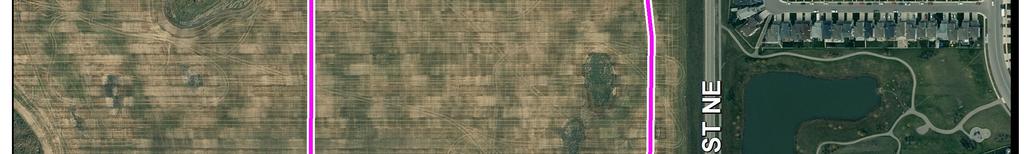
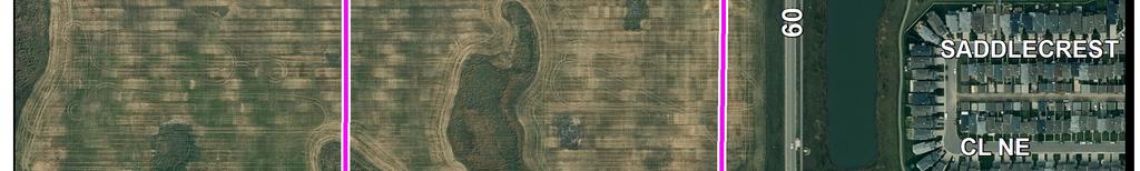
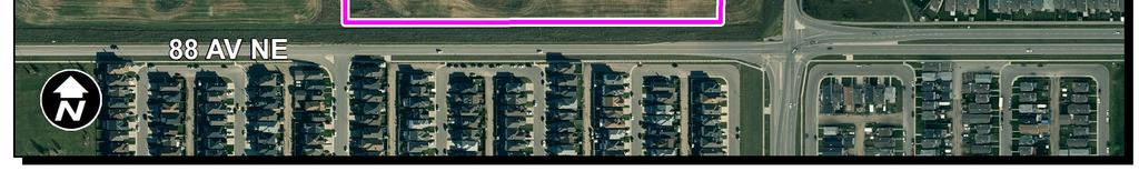
8 Page 8 of 13 PLANNING EVALUATION SITE CONTEXT The subject site is located in the northern boundary of the community of Saddle Ridge. The lands are located in an actively developing area of the city. Adjacent land uses include: low density residential to the east and south, developing residential to the north (Cityscape) and the approved land use/outline plan area of Savanna Stage 1 to the west. The lands are framed by 88 Avenue NE to the south, and 60 Street NE to the east. The plan uses the established Savanna Stage 1 outline plan area as the western and northern boundaries of the site. Airport trail NE is located further north. A future (LRT) station is anticipated for the southeast corner of the subject lands. LAND USE DISTRICTS The Savanna Stage 2 Community Activity Centre represents a transit-oriented Community Activity Centre. A range of commercial, multi-residential, and special purpose land use districts are proposed in order to facilitate the development of a walkable, mixed use development centered around a suburban LRT station. The land uses within the plan area consist of the: Multi-residential Medium Profile (M-2) District. Multi-residential Medium Profile Support Commercial (M-X2) District. Multi- Residential Low Profile Support Commercial (M-X1) District, Commercial- Corridor 2 (C-COR2) District, Multi-Residential- Low Profile (M-1) District and Special Purpose- City and Regional Infrastructure (S-CRI) District. The south of the plan (sites 7 and 8) area is proposed as a community level commercial development districted with the C-COR2 land use designated. The C-COR2 land use district will allow for both the provision of a first generation commercial development in the short term and redevelopment potential over time as the community and infrastructure are built to support it. A private road is located within this area across the north side of the site which is intended to provide direct connection, and pedestrian activity area through the C-COR2 site to the transit hub. Small and medium format retail uses are intended to line the private street and provide a pleasant pedestrian experience. M-X1 and M-X2 land use districts are located north of the C-COR2 site on sites 5 and 6 as shown on the outline plan. These land use districts require minimum amounts of support commercial on each block. This is in line with TOD policy requiring horizontal and vertical mixed use developments. If approved, a minimum of 300 square metres per site of mixed use non residential development is required at the outset of the project. A future LRT station which functions as an extension of the Northeast LRT line is proposed on the east side of the application area. A transit hub and LRT park and ride are proposed directly adjacent to the future LRT station ensuring maximum convenience for public transit users.
9 Page 9 of 13 North of Savanna Boulevard NE M-X1, M-2 and M-1 Land Use Districts provide transition area toward the approved Savanna Stage 1 area. Height and density generally decrease gradually from the future LRT station. The one exception to this policy is the M-X2 land use district on site 4. The size, shape, adjacency to a park, vehicular accessibility, and pedestrian accessibility to this site give the site additional carrying capacity. The rest of the plan area north from the proposed transit station gradually decreases in density through to the approved Savanna Stage 1 neighbourhood. LEGISLATION & POLICY The proposed development has been reviewed in accordance with the existing statutory policy: Municipal Development Plan The subject lands are shown on the Urban Structure Map of the MDP (Map 1) as included within the Developing Planned Greenfield areas with an existing Area Structure Plan. Through the approval process of Savanna Stage 1 an amendment to Map 1 of the MDP, Urban Structure, was completed with the intended CAC now shown on that map. Area Structure Plan The subject lands are located within the Saddle Ridge Area Structure Plan (SRASP). The SRASP identifies the subject lands as a community activity centre and future LRT station. The plan was amended concurrently with the Saddle Ridge Stage 1 approval process. Section 4.9 of the SRASP defines the policy goals and policies for this Community Activity Centre. As proposed this outline plan complies with, and/or provides the framework necessary to achieve these policy goals at the subdivision/development permit stage. The proposal specifically achieves a number of policies from the ASP including but not limited to: A healthy mix of residential, commercial, and special purpose districts with no type exceeding 70 percent of the mix. Land use district which guarantee a mix of residential and commercial uses on individual blocks (M-X1 / M-X2). A private street designed to facilitate the provision of small and medium format retail uses and work as a main pedestrian connection to the future LRT station. A mix of residential housing options at varying densities which provide appropriate transition to adjacent uses. A high degree of connectivity for pedestrians and cyclists through the outline plan area through the grid based street network, provision of regional trails and street typologies.
10 Page 10 of 13 TRANSPORTATION NETWORKS The lands within the outline plan boundary are framed by divided arterial streets: 88 Avenue NE along the southern boundary and 60 Street NE along the eastern boundary. Included within the right-of-way for 60 Street is the future Light Rail Transit (LRT) alignment and station area. The LRT alignment will eventually be a ±1 kilometre extension from its existing terminus at Saddletown Station. The Station area contains an LRT platform, park and ride lot and bus terminal. Access for the lands will be provided at the intersection of 88 Avenue, a divided arterial roadway and Savanna Street NE, a primary collector roadway. The intersection of 88 Avenue and Savanna Street NE is to be signalized as a requirement of the Savanna Stage 1 outline plan. Savanna Drive, a local collector roadway also intersects with 88 Avenue. However, access to 88 Avenue via Savanna Drive NE will be restricted to right turns-in and right-turns out due to its proximity to the adjacent major intersections. The remainder of internal road network within the outline plan boundary is a modified grid, consisting of local collector streets. The majority of the land within the outline plan boundary is located inside-of the 400 metre LRT station radius and is subject to the City s Transit Oriented Development (TOD) policy. Also, all the lands in the outline plan are within a Community Activity Centre indentified in the Municipal Development Plan (MDP). Special attention will be focused at the tentative and development permit application stages on developing the TOD and Community Activity Centre comprehensively. Emphasis will be placed on developing continuous active transportation mode connections through and between sites. To that effect, a 21.7 metre private road is envisioned as a high street bisecting the boundary between the MX-1 and MX-2 parcels and the C-COR2 parcel to the south. The ultimate design of this road is planned to function as the principle pedestrian connection between the approved Savanna Stage 1 outline plan and the future LRT station area. In addition to the on-site active modes amenities, a comprehensive public regional pathway network has been provided both within and outside of the road right-ofway to enhance active modes travel throughout the outline plan area. An amended Transportation Impact Assessment (TIA) was submitted in support of this application and has been approved by Transportation Planning. The TIA supports a maximum total of 923 units within the outline plan area. If unit totals in excess of 923 are proposed, Transportation will require an addendum to this TIA to determine whether the adjacent road network will support the added volume. UTILITIES & SERVICING Site Servicing evaluated the sanitary and water capacity, storm water management, and provision for private utilities within the project area. At this time capacity for all utilities and servicing is available for the Savanna Stage 2 area. All utilities required to service the plan area will be constructed at the cost of the developer.
11 Page 11 of 13 ENVIRONMENTAL ISSUES A Biophysical Inventory analysis (BIA) and Phase 2 Environmental Site Assessment (ESA) were submitted for the plan area in conjunction with the application for Savanna Stage 1. No significant environmental issues have are present for the Savanna Stage 2 Community Activity Centre. GROWTH MANAGEMENT The proposed amendment(s) does not trigger capital infrastructure investment and therefore there are no growth management concerns at this time. PUBLIC ENGAGEMENT Community Association Comments The Saddle Ridge Community Association was consulted under both the application for Savanna Stage 1 and again through the circulation process for Savanna Stage 2. The community association indicated We have been pleased with what was presented us so far with the updates and finalization of Stage 2 of this neighbourhood. Citizen Comments No citizen comments were received by CPC Report submission date. Public Meetings Open houses for the plan area were conducted for this application through the approval of Stage 1. The Stage 2 area was brought back to the Saddle Ridge Community Association and members of the public to provide an update and solicit feedback and comments. Through this meeting no problems or objections were identified.

12 Page 12 of 13 APPENDIX I APPLICANT S SUBMISSION

13 Page 13 of 13
ADMINISTRATION RECOMMENDATION 2016 November 03. That Calgary Planning Commission recommends APPROVAL of the proposed Land Use Amendment.
 Page 1 of 12 EXECUTIVE SUMMARY This Land Use Amendment application covers an area of 75.76 hectares ± (187.20 acres ±) located in northeast Calgary, bound by Stoney Trail NE to the north, 128 Avenue NE
LAND USE AMENDMENT CORNERSTONE (WARD 3) 60 STREET NE AND COUNTRY HILLS BOULEVARD NE MAP 26NE BYLAW 22D2017
 60 STREET NE AND COUNTRY HILLS BOULEVARD NE MAP 26NE BYLAW 22D2017") Page 1 of 14 EXECUTIVE SUMMARY This Land Use Amendment application covers an area of 43.76 hectares ± (108.14 acres ±) located in northeast Calgary, bound by Country Hills Boulevard NE to the south and
Page 1 of 14 EXECUTIVE SUMMARY This Land Use Amendment application covers an area of 43.76 hectares ± (108.14 acres ±) located in northeast Calgary, bound by Country Hills Boulevard NE to the south and
LAND USE AMENDMENT CORNERSTONE (WARD 3) COUNTRY HILLS BOULEVARD AND STONEY TRAIL NE BYLAW 9D2017
 COUNTRY HILLS BOULEVARD AND STONEY TRAIL NE BYLAW 9D2017") Page 1 of 12 EXECUTIVE SUMMARY This Land Use Amendment application covers an area of 54.92 hectares ± (135.71 acres ±) located in northeast Calgary, bound by Country Hills Boulevard NE to the north and
Page 1 of 12 EXECUTIVE SUMMARY This Land Use Amendment application covers an area of 54.92 hectares ± (135.71 acres ±) located in northeast Calgary, bound by Country Hills Boulevard NE to the north and
ROAD CLOSURE AND LAND USE AMENDMENT SILVER SPRINGS (WARD 1) NORTHEAST OF NOSEHILL DRIVE NW AND SILVER SPRINGS ROAD NW BYLAWS 2C2018 AND 29D2018
 NORTHEAST OF NOSEHILL DRIVE NW AND SILVER SPRINGS ROAD NW BYLAWS 2C2018 AND 29D2018") Page 1 of 19 EXECUTIVE SUMMARY This application proposes redesignating two parcels in the community of Silver Springs from Special Purpose Future Urban Development (S-FUD) District and undesignated road
Page 1 of 19 EXECUTIVE SUMMARY This application proposes redesignating two parcels in the community of Silver Springs from Special Purpose Future Urban Development (S-FUD) District and undesignated road
Land Use Amendment in Southwood (Ward 11) at and Elbow Drive SW, LOC
 at and Elbow Drive SW, LOC") 2018 November 15 Page 1 of 10 EXECUTIVE SUMMARY This land use amendment application was submitted by Rick Balbi Architect on 2017 August 31 on behalf of Sable Developments Ltd, and with authorization from
2018 November 15 Page 1 of 10 EXECUTIVE SUMMARY This land use amendment application was submitted by Rick Balbi Architect on 2017 August 31 on behalf of Sable Developments Ltd, and with authorization from
ADMINISTRATION RECOMMENDATION(S) 2016 November 03. That Calgary Planning Commission recommends APPROVAL of the proposed Land Use Amendment.
 2016 November 03. That Calgary Planning Commission recommends APPROVAL of the proposed Land Use Amendment.") Page 1 of 7 EXECUTIVE SUMMARY This Land Use Amendment application seeks to redesignate a portion of the parcel from Industrial General (I-G) District to Special Purpose City and Regional Infrastructure
Page 1 of 7 EXECUTIVE SUMMARY This Land Use Amendment application seeks to redesignate a portion of the parcel from Industrial General (I-G) District to Special Purpose City and Regional Infrastructure
ADMINISTRATION RECOMMENDATION(S) 2017 June 15. That Calgary Planning Commission recommends APPROVAL of the proposed Land Use Amendment.
 2017 June 15. That Calgary Planning Commission recommends APPROVAL of the proposed Land Use Amendment.") Page 1 of 7 EXECUTIVE SUMMARY The proposed land use amendment seeks to redesignate a Special Purpose Future Urban Development (S-FUD) District parcel in Residual Ward 3 Sub Area 3H to Industrial Outdoor
Page 1 of 7 EXECUTIVE SUMMARY The proposed land use amendment seeks to redesignate a Special Purpose Future Urban Development (S-FUD) District parcel in Residual Ward 3 Sub Area 3H to Industrial Outdoor
ADMINISTRATION RECOMMENDATION(S) 2018 January 25. That Calgary Planning Commission recommend APPROVAL of the proposed Land Use Amendment.
 2018 January 25. That Calgary Planning Commission recommend APPROVAL of the proposed Land Use Amendment.") Page 1 of 9 EXECUTIVE SUMMARY This land use amendment proposes to redesignate a parcel from DC Direct Control District to Multi-Residential Contextual Grade-Oriented (M-CG) District to allow for multi-residential
Page 1 of 9 EXECUTIVE SUMMARY This land use amendment proposes to redesignate a parcel from DC Direct Control District to Multi-Residential Contextual Grade-Oriented (M-CG) District to allow for multi-residential
ADMINISTRATION RECOMMENDATION(S) 2017 February 09. That Calgary Planning Commission recommends APPROVAL of the proposed Land Use Amendment.
 2017 February 09. That Calgary Planning Commission recommends APPROVAL of the proposed Land Use Amendment.") Page 1 of 10 EXECUTIVE SUMMARY This land use amendment application is to accommodate changes to the location of a stormwater retention pond and land use boundaries adjacent to Environmental Reserve in
Page 1 of 10 EXECUTIVE SUMMARY This land use amendment application is to accommodate changes to the location of a stormwater retention pond and land use boundaries adjacent to Environmental Reserve in
POLICY AMENDMENT AND LAND USE AMENDMENT TUXEDO PARK (WARD 9) CENTRE STREET N AND 26 AVENUE NE BYLAWS 36P2017 AND 234D2017
 CENTRE STREET N AND 26 AVENUE NE BYLAWS 36P2017 AND 234D2017") Page 1 of 11 EXECUTIVE SUMMARY This application proposes to redesignate a single parcel of land in the Community of Tuxedo Park from Commercial Corridor 2 (C-COR2 f1h10) District to Mixed Use Active Frontage
Page 1 of 11 EXECUTIVE SUMMARY This application proposes to redesignate a single parcel of land in the Community of Tuxedo Park from Commercial Corridor 2 (C-COR2 f1h10) District to Mixed Use Active Frontage
Outline Plan in Belvedere (Ward 9) at Street SE, LOC (OP)
 at Street SE, LOC (OP)") 2018 October 04 Page 1 of 12 EXECUTIVE SUMMARY This outline plan application was submitted by B&A Planning Group on 2016 July 15, on behalf of Tristar Communities Inc. for 50.14 hectares (123.89 acres)
2018 October 04 Page 1 of 12 EXECUTIVE SUMMARY This outline plan application was submitted by B&A Planning Group on 2016 July 15, on behalf of Tristar Communities Inc. for 50.14 hectares (123.89 acres)
POLICY AMENDMENT AND LAND USE AMENDMENT KILLARNEY/GLENGARRY (WARD 8) NW CORNER OF RICHMOND ROAD AND 33 STREET SW BYLAWS 1P2015 AND 7D2015
 NW CORNER OF RICHMOND ROAD AND 33 STREET SW BYLAWS 1P2015 AND 7D2015") Page 1 of 13 EXECUTIVE SUMMARY This application seeks to redesignate an RC-2 (Residential Contextual One/Two Dwelling) parcel to MC-Gd72 (Multi-Residential Contextual Grade-Oriented) to allow for multi-residential
Page 1 of 13 EXECUTIVE SUMMARY This application seeks to redesignate an RC-2 (Residential Contextual One/Two Dwelling) parcel to MC-Gd72 (Multi-Residential Contextual Grade-Oriented) to allow for multi-residential
LAND USE AMENDMENT DOWNTOWN COMMERCIAL CORE (WARD 7) MACLEOD TRAIL SE AND 5 AVENUE SE BYLAW 254D2017
 MACLEOD TRAIL SE AND 5 AVENUE SE BYLAW 254D2017") Page 1 of 10 EXECUTIVE SUMMARY This Land Use Amendment application seeks to redesignate a full downtown block (currently the YWCA site) from a Direct Control based on the CM-2 District (Land Use Bylaw
Page 1 of 10 EXECUTIVE SUMMARY This Land Use Amendment application seeks to redesignate a full downtown block (currently the YWCA site) from a Direct Control based on the CM-2 District (Land Use Bylaw
An amendment to the Bridgeland-Riverside Area Redevelopment Plan is required to allow for the proposed redesignation.
 Page 1 of 12 EXECUTIVE SUMMARY This application proposes to redesignate the subject parcels from Multi-Residential Contextual Grade Oriented (M-CG) District to Commercial Corridor 1 (C-COR1 f4.5h29) District
OP Council Resolution June 16, Planning and Development Services
 OP-08-01 Council Resolution June 16, 2008 Planning and Development Services Kingsgate Landing Outline Plan Table of Contents 1.0 Introduction 1 1.1 Purpose of Plan 1 1.2 Plan Area Location 1 1.3 Ownership
March 21, 2018 ALCA Meeting. March 21, 2018
 March 21, 2018 ALCA Meeting March 21, 2018 Agenda 1. Process and Timeline 2. Original Submission 3. Revised Submission 4. Next Steps The City of Calgary Role: The City is responsible for capturing and
Local Growth Planning in North Central Green Line Communities
 2018 April 30 Page 1 of 6 EXECUTIVE SUMMARY This report outlines a high-level scope for local growth planning for north central Green Line communities. The catalyst for this review is the significant investments
City of Grande Prairie Development Services Department
 City of Grande Prairie Development Services Department ROYAL OAKS NORTH OUTLINE PLAN OP-07-03 NW 35-71-6 W6M May 7, 2007 Royal Oaks North Outline Plan TABLE OF CONTENTS 1.0 INTRODUCTION........ 3 1.1 Purpose
Arbour Lake Development Application
 Arbour Lake Development Application This public engagement session is intended to share information about the proposal to develop the Hawkwood Farm, answer questions and collect feedback on various parts
Welcome to the Oakridge Centre Open House
 Welcome to the Oakridge Centre Open House Why is the City hosting this event? This open house is to inform you of a rezoning application submitted to the City of Vancouver to amend the existing CD-1 (Comprehensive
GATEWAY AREA STRUCTURE PLAN
 CHESTERMERE GATEWAY AREA STRUCTURE PLAN COMMUNITY OPEN HOUSE SEPTEMBER 22 nd, 2015 PLAN AREA ± 512 hectares (± 1,265 acres) GATEWAY LOCATION UNDEVELOPED LANDS PRESENT AGRICULTURAL USE REGIONAL LAND USE
Welcome. Walk Around. Talk to Us. Write Down Your Comments
 Welcome This is an information meeting introducing the applications for proposed redevelopment of the Yorkdale Shopping Centre site at 3401 Dufferin Street and 1 Yorkdale Road over the next 20+ years,
Bylaw C-1186 Adopted November 5, Planning and Development Services
 Bylaw C-1186 Adopted November 5, 2007 Planning and Development Services CITY OF GRANDE PRAIRIE OFFICE CONSOLIDATION BYLAW C-1186 A Bylaw to adopt the Westgate Area Structure Plan (As Amended by Bylaw C-1186-1,
S o u t h C e n t r a l O u t l i n e P l a n. Leduc Business Park. North Leduc Industrial Area Structure Plan C it y of Led u c.
 Leduc Business Park North Leduc Industrial Area Structure Plan C it y of Led u c Prepared for Farm Air Properties Inc. January, 2007 Table of Contents Page Number 1.0 Purpose of Plan and Definition of
City of Grande Prairie Development Services Department KENNEDY DEVELOPMENTS LTD. OUTLINE PLAN OP-09-01
 City of Grande Prairie Development Services Department KENNEDY DEVELOPMENTS LTD. OUTLINE PLAN OP-09-01 July 27, 2009 TABLE OF CONTENTS 1.0 Introduction... 1 1.1 Plan Area Location & Context... 1 1.2 Ownership
CITY COUNCIL AGENDA REPORT
 CITY COUNCIL AGENDA REPORT Subject: COUNCIL MOTION LRT ALIGNMENT REMOVAL FROM THE TRANSPORTATION MASTER PLAN On February 10, 2016 Councillor Hughes provided notice in accordance with Section 23 of Procedure
ELMVALE ACRES SHOPPING CENTRE MASTER PLAN
 ELMVALE ACRES SHOPPING CENTRE MASTER PLAN Contents 1.0 INTRODUCTION... 2 2.0 LOCATION... 2 3.0 EXISTING CONTEXT... 2 4.0 VISION & GUIDING PRINCIPLES... 2 5.0 LAND USE AND BUILT FORM... 4 5.1 St. Laurent
Staff Report and Recommendation
 Community Planning and Development Planning Services 201 W. Colfax Ave., Dept. 205 Denver, CO 80202 p: 720.865.2915 f: 720.865.3052 www.denvergov.org/cpd TO: City Council Neighborhoods and Planning Committee
Bylaw C-1262 Adopted February 6, Planning and Development Department
 Bylaw C-1262 Adopted February 6, 2012 Planning and Development Department CITY OF GRANDE PRAIRIE BYLAW C-1262 A Bylaw to adopt the Brookfield Neighbourhood Outline Plan THE MUNICIPAL COUNCIL OF THE CITY
178 Carruthers Properties Inc.
 178 Carruthers Properties Inc. Planning Rationale for 178 Carruthers Avenue Site Plan Control Application June 2014 Table of Contents 1.0 Introduction 2.0 Overview of Subject Property 3.0 Current Zoning
John M. Fleming Managing Director, Planning and City Planner. Old East Village Dundas Street Corridor Secondary Plan Draft Terms of Reference
 Report to Planning and Environment Committee To: From: Subject: Chair and Members Planning & Environment Committee John M. Fleming Managing Director, Planning and City Planner Old East Village Dundas Street
Red Fox Commercial Outline Plan
 Red Fox Commercial Outline Plan City of Cold Lake, Alberta Prepared by Durrance Projects Ltd and Ross W. Sharp & Associates Ltd October 2014 Rupert 1 Table of Contents 1. PURPOSE...3 1.1. Location...4
Gold Line Bus Rapid Transit Transit Oriented Development (BRTOD) Helmo Station Area Plan
 Helmo Station Area Plan") Appendix F Gold Line Bus Rapid Transit Transit Oriented Development (BRTOD) Helmo Station Area Plan Introduction and Purpose of the Plan The Gold Line Bus Rapid Transit facility is an eleven-mile dedicated
Appendix F Gold Line Bus Rapid Transit Transit Oriented Development (BRTOD) Helmo Station Area Plan Introduction and Purpose of the Plan The Gold Line Bus Rapid Transit facility is an eleven-mile dedicated
Bylaw No. B-03/2011 Adopted by Airdrie City Council February 21, 2012
 COOPER S CROSSING STAGE 4 Neighbourhood Structure Plan City of Airdrie WESTMARK HOLDINGS LTD. Bylaw No. B-03/2011 Adopted by Airdrie City Council February 21, 2012 CONSULTANTS: LAND USE PLANNING: Southwell
Mill Woods Town Centre Proposed Rezoning LDA
 Mill Woods Town Centre Proposed Rezoning LDA15 0649 The City of Edmonton has received an application for rezoning and an amendment to the Mill Woods Station Area Redevelopment Plan (ARP) for the Mill Woods
RESOLUTION NO. R Refining the route, profile and stations for the Downtown Redmond Link Extension
 RESOLUTION NO. R2018-32 Refining the route, profile and stations for the Downtown Redmond Link Extension MEETING: DATE: TYPE OF ACTION: STAFF CONTACT: Capital Committee Board PROPOSED ACTION 09/13/2018
JASPER PLACE. Area Redevelopment Plan
 JASPER PLACE Area Redevelopment Plan Executive Summary Jasper Place is an established community where people live, work and play. The Jasper Place Area Redevelopment Plan (ARP) provides a tool to help
YONGE STEELES CORRIDOR SECONDARY PLAN. Young + Wright / IBI Group Architects Dillon Consulting Ltd. GHK International (Canada) Ltd.
 Ltd.") PART A: PREAMBLE 1.0 PURPOSE The purpose of this Secondary Plan is to provide a development framework for intensification of the Yonge/ Steeles corridor including the north side of Steeles Avenue West
PART A: PREAMBLE 1.0 PURPOSE The purpose of this Secondary Plan is to provide a development framework for intensification of the Yonge/ Steeles corridor including the north side of Steeles Avenue West
South Macleod Centre. Area Structure Plan
 South Macleod Centre Area Structure Plan 58P2017 September 2017 Publishing information Title South Macleod Centre Area Structure Plan Author The City of Calgary Status Approved by City Council Bylaw 58P2017
Tyvola & Archdale Transit Station Area Plan. May 15, 2008
 Tyvola & Archdale Transit Station Area Plan First Public Meeting May 15, 2008 Presentation Outline 1. Purpose and Process 2. Station Area Overview 3. Plan Recommendations Vision Land Use Transportation
REZONING GUIDE. Zone Map Amendment (Rezoning) - Application. Rezoning Application Page 1 of 3. Return completed form to
 - Application. Rezoning Application Page 1 of 3. Return completed form to") Zone Map Amendment (Rezoning) - Application COMMUNITY PLANNING & DEVELOPMENT REZONING GUIDE Rezoning Application Page 1 of 3 PROPERTY OWNER INFORMATION* CHECK IF POINT OF CONTACT FOR APPLICATION Property
Zone Map Amendment (Rezoning) - Application COMMUNITY PLANNING & DEVELOPMENT REZONING GUIDE Rezoning Application Page 1 of 3 PROPERTY OWNER INFORMATION* CHECK IF POINT OF CONTACT FOR APPLICATION Property
CITY OF CHARLOTTESVILLE, VIRGINIA CITY COUNCIL AGENDA
 CITY OF CHARLOTTESVILLE, VIRGINIA CITY COUNCIL AGENDA Agenda Date: December 16, 2013 Action Required: Adoption of Resolution Presenter: Staff Contacts: Title: James E. Tolbert, AICP, Director of NDS James
URBAN DESIGN BRIEF. 2136&2148 Trafalgar Road. Town of Oakville
 URBAN DESIGN BRIEF 2136&2148 Trafalgar Road Town of Oakville Prepared By: METROPOLITAN CONSULTING INC For 2500674 Ontario Inc November 2016 TABLE OF CONTENTS Page No. 1.0 Introduction/Description of Subject
900 ALBERT PLANNING RATIONALE MARCH 21, 2016 TRINITY
 900 ALBERT PLANNING RATIONALE MARCH 21, 2016 TRINITY PREPARED FOR: TRINITY Trinity Development Group Inc. Sun Life Financial Centre, East Tower 3250 Bloor Street West, Suite 1000 Toronto, ON M8X 2X9 www.trinity-group.com
1.0 Purpose of a Secondary Plan for the Masonville Transit Village
 Report to Planning and Environment Committee To: Chair and Members Planning & Environment Committee From: John M. Fleming Managing Director, Planning and City Planner Subject: Masonville Transit Village
TABLE OF CONTENTS. Sierra Springs Outline Plan
 Sierra Springs Outline Plan TABLE OF CONTENTS 1. Introduction...3 1.1. Purpose of the Plan... 3 1.2. The Approval Process... 3 1.3. Policy and Legislative Framework... 3 2. Development Area...6 2.1. Location
NEC of Central Avenue and Indian School Road
 NEC of Central Avenue and Indian School Road For this location, there are two applicable plans that provide guidance on development. The two plans include the Indian School Specific Plan (1991) and the
Westwind Developments Ltd. PIONEER LANDS AREA STRUCTURE PLAN - PROPOSED AMENDMENT
 FEBRUARY 2013 TABLE OF CONTENTS 1.0 BACKGROUND... 1 1.1 Amendment... 1 2.0 LOCATION & CONTEXT... 2 2.1 Land Ownership... 2 3.0 POLICY CONTEXT... 3 3.1 Municipal Development Plan... 3 3.2 Capital Region
MOUNT PLEASANT SECONDARY PLAN & VILLAGE BLOCK PLAN. Wednesday, March 5, 2008 Informal Public Open House
 MOUNT PLEASANT SECONDARY PLAN & VILLAGE BLOCK PLAN Wednesday, March 5, 2008 Informal Public Open House 1. Welcome & Introductions 2. Highlights of Provincial Growth Plan 3. Overview and Status Update -
Minto In Kensington Open House. Thursday March 23, pm Hillhurst Sunnyside Community Association Ave NW
 Minto In Kensington Open House Thursday March 23, 2017 6-8 pm Hillhurst Sunnyside Community Association 1320 5 Ave NW Project Background & Timeline Background Project Highlights Minto Communities continues
WEST HILL BUSINESS PARK AREA STRUCTURE PLAN
 MUNICIPAL DISTRICT OF PEACE NO. 135 WEST HILL BUSINESS PARK AREA STRUCTURE PLAN Prepared by: TABLE OF CONTENTS 1.0 Introduction... 1 1.1 Purpose of Plan........ 1 1.2 Plan Area..... 1 1.3 Existing Conditions...
Providence. Area Structure Plan
 Providence Area Structure Plan PUBLISHING INFORMATION Title: Author: Status: Printing Date: Additional Copies: Providence Area Structure Plan Local Area Planning and Implementation Planning, Development
SUBJECT: Proposed Downtown Mobility Hub Precinct Plan and Proposed Official Plan Policies
 Page 1 of Report PB-81-17 SUBJECT: Proposed Downtown Mobility Hub Precinct Plan and Proposed Official Plan Policies TO: FROM: Committee of the Whole Planning and Building Department Report Number: PB-81-17
Former Rockcliffe Airbase Community Design Plan Guiding Design Vision and Principles December 4, 2013
 APPENDIX 5 - Guiding Design Vision and Principles Former Rockcliffe Airbase Community Design Plan Guiding Design Vision and Principles December 4, 2013 Vision Statement The redevelopment of the former
9 CITY OF VAUGHAN OFFICIAL PLAN AMENDMENT NO BOCA EAST INVESTMENTS LIMITED
 9 CITY OF VAUGHAN OFFICIAL PLAN AMENDMENT NO. 631 - BOCA EAST INVESTMENTS LIMITED The Planning and Economic Development Committee recommends the adoption of the recommendations contained in the following
Welcome. Green Line LRT. Beltline Alignment Options. Stay engaged! Follow the Green Line story at calgary.ca/greenline
 Welcome Green Line LRT Beltline Alignment Options Stay engaged! Follow the Green Line story at calgary.ca/greenline Green Line LRT Why are we here? Our Challenge Determine the best alignment in the Beltline.
Port Credit Local Advisory Panel October 20 th Meeting
 Port Credit Local Advisory Panel October 20 th Meeting Focus Of This Evening s Meeting: 1. Hurontario Main Street Higher Order Transit Study 2. Port Credit Mobility Hub & GO Station Parking Structure Study
The transportation system in a community is an
 7 TRANSPORTATION The transportation system in a community is an important factor contributing to the quality of life of the residents. Without a sound transportation system to bring both goods and patrons
hermitage town center
 hermitage town center A Community Vision prepared by Strada for The City of Hermitage and The Mercer County Regional Planning Commission January 2007 table of contents introduction 3 design principles
Regency Developments. Urban Design Brief. Holyrood DC2 Rezoning
 Regency Developments Urban Design Brief Holyrood DC2 Rezoning Stantec Consulting Ltd. 7-31-2017 1. Overview Regency Developments intends to rezone the lands located at 8510 and 8511 93 Avenue, within the
1.3 TRANSIT VISION 2040 FROM VISION TO ACTION THEME 1: PUTTING TRANSIT AT THE CENTRE OF COMMUNITIES. Fully integrate transit with community planning
 TRANSIT VISION 2040 FROM VISION TO ACTION TRANSIT VISION 2040 defines a future in which public transit maximizes its contribution to quality of life with benefits that support a vibrant and equitable society,
CHAPTER 1. Ms. Guajardo s Class - Central Elementary CH 1 1
 INTRODUCTION CHAPTER 1 Ms. Guajardo s Class - Central Elementary CH 1 1 1.1 SETTING South Centre City is a linear corridor south of Downtown Escondido paralleling Centre City Parkway and South Escondido
URBAN DESIGN BRIEF URBAN DESIGN BRIEF 721 FRANKLIN BLVD, CAMBRIDGE August 2018
 URBAN DESIGN BRIEF URBAN DESIGN BRIEF 721 FRANKLIN BLVD, CAMBRIDGE August 2018 DESIGN BRIEF CONTENTS PART A 1.0 INTRODUCTION 2.0 DESCRIPTION & ANALYSIS OF SITE CONTEXT 3.0 DESIGN CONSTRAINTS AND OPPORTUNITIES
4780 Eglinton Avenue West - Zoning By-law Amendment and Draft Plan of Subdivision Applications - Preliminary Report
 STAFF REPORT ACTION REQUIRED 4780 Eglinton Avenue West - Zoning By-law Amendment and Draft Plan of Subdivision Applications - Preliminary Report Date: May 29, 2014 To: From: Wards: Reference Number: Etobicoke
FUTURE LAND USE ELEMENT
 FUTURE LAND USE ELEMENT GOAL I: To create and sustain a great place to live, play, and prosper Objective 1: The City of Ocala shall incorporate the principles and strategies of the Ocala 2035 Vision into
Chapter 1.0 Introduction
 Chapter 1.0 Introduction 1.1 Background The North Metro commuter rail line is part of the RTD FasTracks regional transit system expansion program to build more than 100 miles of rail transit throughout
SECTION E. Realizing the Plan
 SECTION E Realizing the Plan 60 DESIGN REGINA - OFFICIAL COMMUNITY PLAN SECTION E Realizing the Plan Design Regina has been an ambitious plan-making exercise, with a high level of community, stakeholder,
Evaluation Criteria. Detailed Evaluation Criteria
 Evaluation Criteria Detailed Evaluation Criteria Community Well-being A safe and socially inclusive service that improves access to key community destinations and provides transportation choices for Calgarians.
Report to: Development Services Committee Report Date: September 11, 2017
 ~RKHAM Report to: Development Services Committee Report Date: September 11, 2017 SUBJECT: PREPARED BY: Conceptual Master Plan for the Future Urban Area - Community Structure Plan and Key Policy Direction
Official Plan Review
 Official Plan Review Summary Report - The Built Environment August 2014 Part 1: Introduction Planning for a healthy, prosperous and sustainable community is an important goal for our municipality. From
GUIDELINES. Transit Oriented Development. Approved by Edmonton City Council on February 15, 2012 in tandem with City Policy C565
 Transit Oriented Development GUIDELINES Prepared by the City of Edmonton Sustainable Development and Transportation Services Departments Approved by Edmonton City Council on February 15, 2012 in tandem
RECOMMENDATION(S) OF THE CALGARY PLANNING COMMISSION
 OF THE CALGARY PLANNING COMMISSION") Page 1 of 21 EXECUTIVE SUMMARY This DC Direct Control District application is intended to bring consistency between the Stadium Shopping Centre Area Redevelopment Plan (ARP) that was approved by Council
Page 1 of 21 EXECUTIVE SUMMARY This DC Direct Control District application is intended to bring consistency between the Stadium Shopping Centre Area Redevelopment Plan (ARP) that was approved by Council
Report to: Development Services Committee Report Date: April 24, 2017
 SUBJECT: Cornell Rouge National Urban Park Gateway - Report on Design Charrette and Next Steps PREPARED BY: Lilli Duoba, MES, MCIP, RPP, Manager, Natural Heritage (ext. 7925) REVIEWED BY: Marg Wouters,
1 INTRODUCTION Purpose Project Background PROJECT CONTEXT Background The Capital City Downtown Plan...
 Attachment 3 Contents CONTENTS 1 INTRODUCTION... 3 Purpose... 3 Project Background... 3 2 PROJECT CONTEXT... 9 Background... 9 The Capital City Downtown Plan... 9 The LRT Expansion Plan - LRT Downtown
3 TOWN OF WHITCHURCH-STOUFFVILLE OFFICIAL PLAN AMENDMENT NOS. 116 & 117
 3 TOWN OF WHITCHURCH-STOUFFVILLE OFFICIAL PLAN AMENDMENT NOS. 116 & 117 The Planning and Economic Development Committee recommends the adoption of the recommendations contained in the following report,
THE NEW COMMUNITY PLANNING GUIDEBOOK
 MUNICIPAL DEVELOPMENT PLAN: VOLUME 2, PART 1 THE NEW COMMUNITY PLANNING GUIDEBOOK Adopted by Council [Approval Date] calgary.ca contact 311 Onward/ We will create great communities with quality living
Summerside Neighbourhood Structure Plan
 Summerside Neighbourhood Structure Plan Office Consolidation July 2012 Prepared by: Current Planning Branch Sustainable Development City of Edmonton Bylaw 12112 (as amended) was adopted by Council on September
Edward R. Sajecki Commissioner of Planning and Building
 Corporate Report Clerk s Files Originator s Files CD.03.POR DATE: TO: FROM: SUBJECT: Chair and Members of Planning and Development Committee Meeting Date: February 27, 2012 Edward R. Sajecki Commissioner
SUBJECT: GO Station Mobility Hubs Preferred Concepts: Aldershot GO, Burlington GO and Appleby GO. Planning and Development Committee - Public Meeting
 Page 1 of Report PB-76-17 SUBJECT: GO Station Mobility Hubs Preferred Concepts: Aldershot GO, Burlington GO and Appleby GO TO: FROM: Planning and Development Committee - Public Meeting Planning and Building
Municipal Development Plan Update Urban Service Area and Hamlets
 ENCLOSURE 1 Municipal Development Plan Update Urban Service Area and Hamlets Priorities Committee January 24, 2017 MUNICIPAL DEVELOPMENT PLAN UPDATE SHAPING OUR FUTURE MDP Update - Agenda MDP Update Public
Coliseum Station Area Area Redevelopment Plan. Public Engagement #1 June 12, 2017
 Coliseum Station Area Area Redevelopment Plan Public Engagement #1 June 12, 2017 Welcome Engagement Purpose Introduce the project Share information Gather input Project Updates & Newsletter edmonton.ca/coliseumplan
AREA STRUCTURE PLAN NE W5M. Adopted by Council September 27, 2010 Bylaw
 AREA STRUCTURE PLAN NE 5-33-1 W5M Adopted by Council September 27, 2010 Bylaw 2010-14 CONTENTS 1.0 Introduction... 3 1.1 Purpose... 3 1.2 Objectives... 3 1.3 Discovery Plains Community Vision... 3 1.3.1
Employment and Commercial Review Analysis of Policy Directions
 Employment and Commercial Review Analysis of Policy Directions Appendix A The following analysis is town staff s response to the policy directions provided by the consultants who prepared the Employment
ARLINGTON COUNTY, VIRGINIA
 ARLINGTON COUNTY, VIRGINIA County Board Agenda Item Meeting October 15, 2005 DATE: September 28, 2005 SUBJECT: Request to Advertise the adoption of the 2005 Clarendon Sector Plan C. M. RECOMMENDATION:
C ity of Grande Prairie Development Services Department
 C ity of Grande Prairie Development Services Department FAIRWAY DEVELOPMENT OUTLINE PLAN OP 08 09 Approved April 6, 2009 Prepared by: Focus Corporation Table of Contents 1.0. Introduction 2 3 1.1. Plan
The Uplands Area Structure Plan. City of Cold Lake, NE & SE W4
 City of Cold Lake, NE & SE 13-63-2-W4 July 2009 1 Contents 1 Background information... 1 1.1 Foreword... 1 1.2 Purpose... 1 1.3 Plan Area and Location... 1 1.4 Ownership... 2 2 Factors Influencing Development...
The Corporation of the TOWN OF MILTON
 Report to: From: Chair & Members of the Administration & Planning Standing Committee W.F. Mann, Director of Planning and Development Date: April 16, 2012 PD 022-12 (Z19/11) Subject: Technical Report Proposed
BROOKHILL NEIGHBORHOOD MODEL ZONING MAP AMENDMENT PREFACE TO APPLICATION
 BROOKHILL NEIGHBORHOOD MODEL ZONING MAP AMENDMENT PREFACE TO APPLICATION June 15, 2015 Revised: August 1, 2016 I. VISION Brookhill is a proposed community based upon the principles of Albemarle County
Corridor Vision. 1Pursue Minnehaha-Hiawatha Community Works Project. Mission of Hennepin County Community Works Program
 1Pursue Minnehaha-Hiawatha Community Works Project Minnehaha-Hiawatha Community Works is a project within the Hennepin Community Works (HCW) program. The mission of the HCW program is to enhance how the
Phase 1 Concept Plan MAY 26, Version Circulation Draft
 Phase 1 Concept Plan MAY 26, 2014 Version 2.0 - Circulation Draft Project Team: Project Engineers WSP/Genivar Contact: Jeff Halliday 306.585.1990 Phase 1 Concept Plan May 2014 Prepared for: Westerra Development
City of Tacoma Planning and Development Services
 Agenda Item E-1 City of Tacoma Planning and Development Services To: Planning Commission From: Elliott Barnett, Planning Services Division Subject: Tacoma Mall Regional Center Subarea Plan and EIS Meeting
Transportation. Strategies for Action
 Transportation A major priority for the Overlake Neighborhood is to develop a multimodal transportation system. To achieve this system, a balance has to be found among travel, circulation and access needs;
Northwest Rail Corridor and US 36 BRT Development Oriented Transit Analysis 4.4 STATION AREA FINDINGS
 4.4 STATION AREA FINDINGS Each station is different, and each one requires a separate set of recommendations based on the vision for the site. This section outlines an initial TOD strategy and recommendations
2 STATUTORY PUBLIC MEETING AND INFORMATION REPORT FOR PUBLIC MEETING ON AMENDMENT NO. 62 TO THE YORK REGION OFFICIAL PLAN
 2 STATUTORY PUBLIC MEETING AND INFORMATION REPORT FOR PUBLIC MEETING ON AMENDMENT NO. 62 TO THE YORK REGION OFFICIAL PLAN Pursuant to Section 17(15) of the Planning Act, as amended, the Regional Planning
12 AMENDMENT NO. 149, TOWN OF MARKHAM HIGHWAY 404 NORTH SECONDARY PLAN
 12 AMENDMENT NO. 149, TOWN OF MARKHAM HIGHWAY 404 NORTH SECONDARY PLAN The Planning and Economic Development Committee recommends the adoption of the recommendation contained in the following report August
McCowan Precinct Plan Study Background & Deliverables
 1 DRAFT & WITHOUT PREJUDICE McCowan Precinct Plan Study Background & Deliverables In September, 2011, City Planning (Scarborough District) began a study of an area within the Scarborough Centre, identified
Auburn Bay Community Plan
 Auburn Bay Community Plan Auburn Bay Community Plan Office Consolidation June 2007 Bylaw 15P2003 Approved January 19, 2004 Note: This office consolidation includes the following amending Bylaws: Amendment
ONTARIO MUNICIPAL BOARD
 PL 120483 ONTARIO MUNICIPAL BOARD Applicant/Appellant: 2124123 Ontario Limited Subject: OPA, Rezoning and Draft Plan of Subdivision Municipal Address: 3940 Highway 7 East Municipality: City of Markham
master plan of highways bus rapid transit amendment
 Scope of Work master plan of highways bus rapid transit amendment September 2011 Montgomery County Planning Department M-NCPPC MontgomeryPlanning.org 1 Scope of Work master plan of highways bus rapid transit
CPC ATTACHMENT 3 CPC AMENDMENTS PROPOSED. calgary.ca contact 311 HASKAYNE AREA STRUCTURE PLAN 01
 CPC2015-126 ATTACHMENT 3 CPC AMENDMENTS PROPOSED calgary.ca contact 311 HASKAYNE AREA STRUCTURE PLAN 01 Title: Author: Status: PUBLISHING INFORMATION Haskayne Area Structure Plan Local Area Planning and