Department of Planning and Community Development
|
|
|
- Alfred Dennis
- 6 years ago
- Views:
Transcription

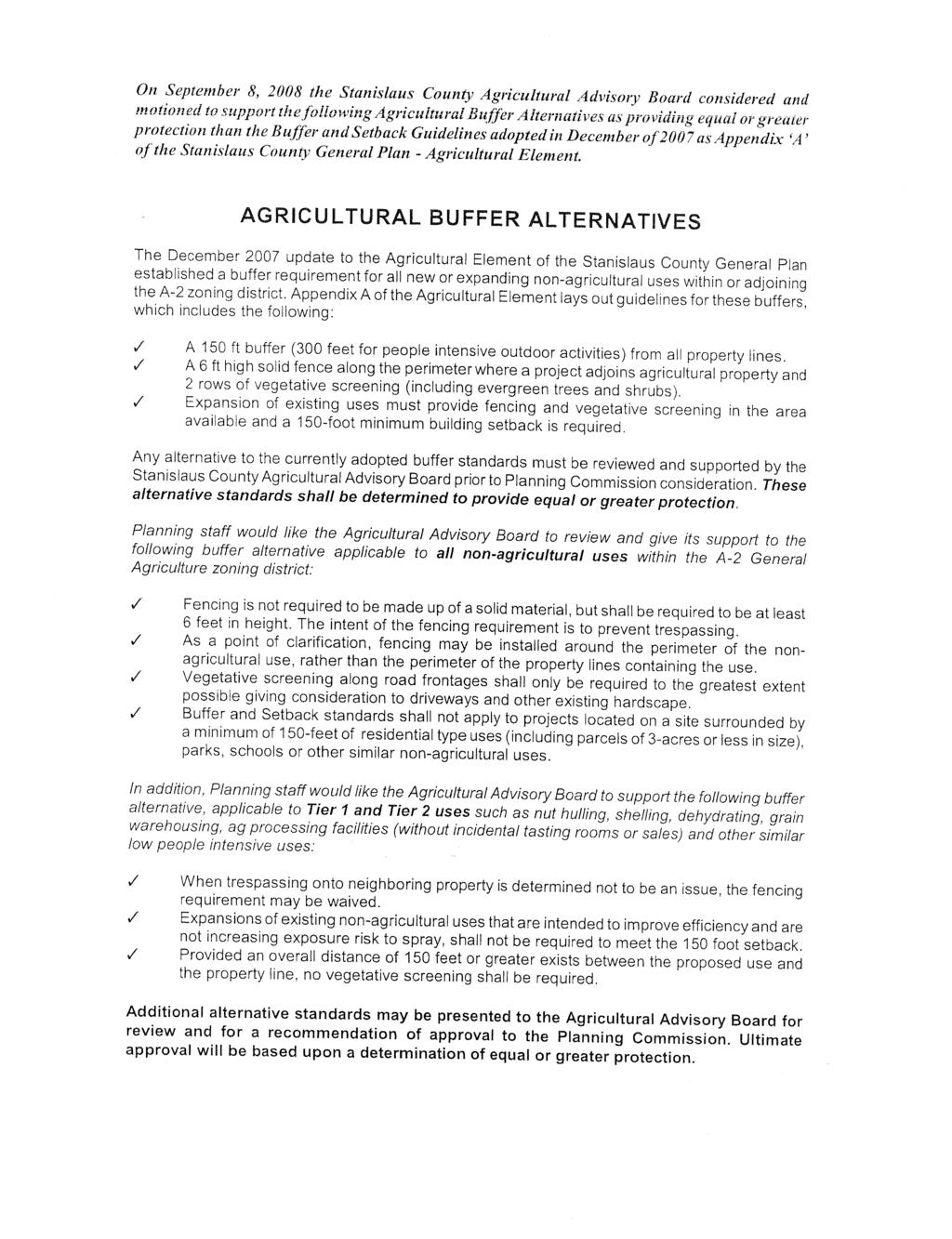
1 DEPARTMENT OF PLANNING AND COMMUNITY DEVELOPMENT TH Street, Suite 3400, Modesto, CA Phone: Fax: August 1, 2011 MEMO TO: FROM: Agricultural Advisory Board Department of Planning and Community Development SUBJECT: USE PERMIT APPLICATION NO MC HENRY SOLAR FARM- ALTERNATIVE AGRICULTURAL BUFFER AND SETBACKS The Stanislaus County Department of Planning and Community Development has received an application to establish a photovoltaic (PV) solar energy farm creating an aggregate peak power capacity of 25 megawatts (MW) of electricity on a 155± acre site, located at 221 Patterson Road, at the northeast corner of McHenry Avenue and Patterson Road, in the Del Rio area. Major components of the proposed Solar Star and MID facilities are: Solar field comprised of a combination of 1- and 1.5- MW power blocks, on-site substation, operations and maintenance building, 69-kV electrical switchyard, and a 700± foot long 69kV double-circuit overhead electric sub-transmission line and 12kV distribution line. Additional site improvements include: access roads, security fencing, lighting, and landscaping. The applicant has proposed an alternative to the Agricultural Buffer and Setback Guidelines. The County s Buffer and Setback Guidelines and the applicant s proposal are outlined below: Stanislaus County Buffer & Setback Guidelines Requirements for New Non-Agricultural Uses: A minimum 150-feet wide buffer, measured from the property line of any adjoining property located in the A-2 zoning district, shall be incorporated. All buffers shall include solid fencing and vegetative screening consistent with the guidelines. In general, vegetative screen shall consist of two staggered rows of trees and shrubs characterized by evergreen foliage extending from the base of the plant to the crown. Fencing: The Agricultural Advisory Board in September of 2008 supported a general alternative clarifying the intent of the fencing requirement is to prevent trespassing. As part of the general alternative, fencing is not required to be made up of a solid material, but is required to be at least 6-feet in height. Fencing may be installed around the perimeter of the non-agricultural use, rather than the perimeter of the property lines containing the use. Applicant s Proposal The applicant is requesting the following alternative agricultural buffer for the northern and eastern boundaries of the project: 45-foot-wide buffer on the northern property line, 6-foot cyclone fencing, no vegetative screening; 110-foot-wide buffer on the eastern property line, 6-foot cyclone fencing, no vegetative screening;
2 UP Alternative Ag Buffer and Setbacks August 1, 2011 Page 2 Staff s Comments The western and southern boundaries of the project comply with Agricultural Buffer. The Stanislaus County Buffer and Setback Guidelines permit utilities and similar low intensive uses in the buffer area. Because utilities are allowed in the required setback area staff believes the modified northern and eastern setbacks are adequate; however, it is up to the AAB to determine if the lack of vegetative screening along these boundaries is acceptable. In the past, the Agricultural Advisory Board has approved alternative buffers for solar farm. These alternative buffers included 6-foot cyclone fencing for security purposes, modified setbacks and no vegetative screening. Interior lot line setbacks have not been addressed due to the nature of the proposed development and the project sites single common ownership. Beyond the construction phase, the potential for impacts associated with on-site employees and related activities will be minimal. I:\Planning\Staff Reports\UP\2011\UP McHenry Solar Farm\AAB Buffers\1 - Ag Advisory Comm - Alt Buffer.wpd
3
4
5 TERMINAL AVE STANISLAUS RIVER HOGUE RD STEWART RD LADD RD PATTERSON RD Union Pacific OAKDALE RD COFFEE RD SKITTONE RD MID MAIN ST FRANCIS AVE HETCH HETCHY AQUADUCT MC HENRY AVE TULLY RD KIERNAN AVE CARVER RD "! 99 UP MC HENRY SOLAR FARM Vicinity Map DEL RIO MODESTO RIVERBANK N
6 ST JOHNS RD Union Pacific COFFEE RD 2.85 UP MC HENRY SOLAR FARM General Plan & Zoning Map LDR/R-A PD/PD STEWART RD HARTLEY DR AG/A AG/A SITE LADD RD 1.00 MC HENRY AVE PATTERSON RD N MID MAIN SKITTONE RD
7 UP MC HENRY SOLAR FARM 2008 Stanislaus County Aerial MC HENRY AVE N PATTERSON RD
8 UP MC HENRY SOLAR FARM 2008 Stanislaus County Aerial STEWART RD MC HENRY AVE ST JOHNS RD SKITTONE RD PATTERSON RD N

 074-007-004 29.28acres 074-007-018 20.04acres 074-007-019 9.")

9 MC HENRY AVE acres O WY B ELTIS DR acres acres SHERRY LN SPY GLASS DR STEWART RD acres acres acres acres HARTLEY DR acres acres acres acres Project Site acres acres acres acres Agriculture acres acres Project Location " 19.73acres Stanislaus County 19.71acres acres acres acres acres Residence (not part of project) acres acres acres acres LADD RD PATTERSON RD San Joaquin County ST 99 ST 108 ST 132 Merced County T 0 1,000 Feet Zoning Designation EXCLUSIVE AGRICULTURE- 40 ACRE PLANNED DEVELOPMENT RURAL RESIDENTIAL Modesto Main Canal SKITTONE RD acres acres acres acres acres acres acres acres acres SOURCE: Stanislaus County GIS, 2010 McHenry Solar Farm Figure 2-1 Project Site Location Map 2-3

10 Project Site SOURCE: SunPower, 2010 McHenry Solar Farm Figure 2-2 Project Site Plan 2-7

11 SOURCE: SunPower, 2010 Note: Views A and B depict typical variability of planting patterns along the landscape buffer. McHenry Solar Farm Figure 2-5 Conceptual Landscape Plan 2-13

12 a. Photos 9 and 10: Existing view from the west side of McHenry Avenue looking east though southeast. The Project site is the green area in the middle of the photo. The dirt road and gate on the left side of the photo are the northern boundary of the Project site b. Simulated view of Photos 9 and 10 showing the entrance gate to the solar farm and the landscape screening along the western boundary of the Project site; solar panels are not visible behind the landscape screening. The proposed interconnection sub-transmission, distribution, and fiber optic lines are shown on new poles along the northern boundary of the site, beginning at the interconnection pole in the foreground. SOURCE: ESA McHenry Solar Farm Figure Visual Simulation of Proposed Interconnection

13 a. Photos 10 and 11: Existing view from the west side of McHenry Avenue looking southeast though south. The Project site is the green area in the left-middle of the photo. MID s existing Ladd-Clough sub-transmission line is shown along the west side of McHenry Avenue on the right side of the photo b. Simulated view of Photos 10 and 11 showing the landscape screening and fence along the western boundary of the Project site; solar panels are not visible behind the landscape screening. The interconnection pole is shown in the foreground. SOURCE: ESA McHenry Solar Farm Figure Visual Simulation of Western Project Boundary
Department of Planning and Community Development
 DEPARTMENT OF PLANNING AND COMMUNITY DEVELOPMENT 1010 10 TH Street, Suite 3400, Modesto, CA 95354 Phone: 209.525.6330 Fax: 209.525.5911 August 1, 2011 MEMO TO: FROM: Agricultural Advisory Board Department
Referral Early Consultation
 DEPARTMENT OF PLANNING AND COMMUNITY DEVELOPMENT 1010 10 TH Street, Suite 3400, Modesto, CA 95354 Planning Phone: (209) 525-6330 Fax: (209) 525-5911 Building Phone: (209) 525-6557 Fax: (209) 525-7759 Date:
Campus Infrastructure Overlay Land Use Designation
 Appendix G LRDP Amendment 3 Campus Infrastructure Overlay Land Use Designation Introduction The West Campus Solar Farm Project will provide sustainable and renewable energy to serve the UCR campus. The
DEL RIO COMMUNITY PLAN DEPARTMENT OF PLANNING AND COMMUNITY DEVELOPMENT
 DEL RIO COMMUNITY PLAN DEPARTMENT OF PLANNING AND COMMUNITY DEVELOPMENT AUGUST 1992 TABLE OF CONTENTS I. INTRODUCTION... 1 II. GOALS AND POLICIES... 5 III. LAND USE PLAN... 8 IV. CIRCULATION PLAN... 17
2005 LRDP Amendment 3
 2005 LRDP Amendment 3 LONG RANGE DEVELOPMENT PLAN 2005 LRDP AMENDMENT 3 ii 2005 LRDP AMENDM ENT 3 LAND USE 2005 LRDP Amendment 3 Campus Infrastructure Overlay Land Use Designation September 2013 iii LONG
Referral Early Consultation
 DEPARTMENT OF PLANNING AND COMMUNITY DEVELOPMENT 1010 10 TH Street, Suite 3400, Modesto, CA 95354 Planning Phone: (209) 525-6330 Fax: (209) 525-5911 Building Phone: (209) 525-6557 Fax: (209) 525-7759 Date:
Loudoun to Pleasant View 500kV Rebuild & Brambleton to Mosby 500kV Projects
 Loudoun to Pleasant View 500kV Rebuild & Brambleton to Mosby 500kV Projects Project Details 13 mile line, originally build in the 1960 s, crosses three county magisterial districts Blue Ridge, Dulles and
Referral Early Consultation
 DEPARTMENT OF PLANNING AND COMMUNITY DEVELOPMENT 1010 10 th Street, Suite 3400, Modesto, CA 95354 Phone: 209.525.6330 Fax: 209.525.5911 Date: February 14, 2017 Referral Early Consultation To: Distribution
3. ENVIRONMENTAL SETTING, IMPACTS, AND MITIGATION MEASURES
 3. ENVIRONMENTAL SETTING, IMPACTS, AND MITIGATION MEASURES Organization of this Chapter This chapter presents the environmental setting of the project for the various impact categories, and then evaluates
11 October 8, 2014 Public Hearing
 11 October 8, 2014 Public Hearing APPLICANT: T-MOBILE NORTHEAST, LLC PROPERTY OWNER: DOMINION VIRGINIA POWER STAFF PLANNER: Graham Owen REQUEST: Conditional Use Permit (Wireless Communication Tower) ADDRESS
Appendix I-A3 DENAIR COMMUNITY PLAN
 Appendix I-A3 DENAIR COMMUNITY PLAN Adopted by the Stanislaus County Board of Supervisors DECEMBER 15, 1998* *A technical update removing reference to the former Stanislaus County Redevelopment Agency
Referral Early Consultation
 DEPARTMENT OF PLANNING AND COMMUNITY DEVELOPMENT 1010 10 th Street, Suite 3400, Modesto, CA 95354 Phone: 209.525.6330 Fax: 209.525.5911 Date: April 29, 2016 Referral Early Consultation To: Distribution
4.1 AESTHETICS WATSON INDUSTRIAL PARK ENVIRONMENTAL IMPACT REPORT EXISTING CONDITIONS
 This Subsection describes the aesthetic qualities and visual resources present on the Project site and in the site s vicinity and evaluates the potential effects that the Project may have on these resources.
THE PLANNING AREA 2.1 PLANNING AREA LOCATION
 2. The Planning Area Brisbane Baylands Specific Plan 21 2 THE PLANNING AREA 2.1 PLANNING AREA LOCATION The Baylands is located approximately midway between San Francisco s central business district and
Appendix I-A8 SALIDA COMMUNITY PLAN
 Appendix I-A8 SALIDA COMMUNITY PLAN Adopted by the Stanislaus County Board of Supervisors AUGUST 7, 2007 *A technical update clarifying the integration of the 2007 Salida Area Planning, Road Improvement,
HEALTH SCIENCES BUILDING REDEVELOPMENT PROJECT
 INTRODUCTION In recent years, the University of Cincinnati (University) has demonstrated a commitment to identifying and implementing sustainable goals and objectives throughout University s Uptown Campuses.
Request Conditional Rezoning (R-15 Residential to Conditional A-24 Apartment) Staff Recommendation Approval. Staff Planner Jimmy McNamara
 Staff Recommendation Approval. Staff Planner Jimmy McNamara") Applicant Franklin Johnston Group Management & Development, LLC Property Owner Virginia Wesleyan College Public Hearing July 12, 2017 City Council Election District Bayside Agenda Item 3 Request Conditional
Applicant Franklin Johnston Group Management & Development, LLC Property Owner Virginia Wesleyan College Public Hearing July 12, 2017 City Council Election District Bayside Agenda Item 3 Request Conditional
Monday, September 14, :00 A.M. AV 201 Conference Room AGENDA
 SAN JOAQUIN COUNTY MULTI-SPECIES HABITAT CONSERVATION AND OPEN SPACE PLAN HABITAT TECHNICAL ADVISORY COMMITTEE MEETING & HTAC FINANCIAL SUB-COMMITTEE MEETING San Joaquin Council of Governments Regional
Colerain Township report to. Hamilton County Regional Planning Commission. December 2, 2010, 1:00PM. t a f f r e p o r t
 Colerain Township report to Hamilton County Regional Planning Commission December 2, 2010, 1:00PM Preliminary Plan: Case No.: ZA2001-04, Forevergreen Prepared By: Amy Bancroft, Land Use Planner t a f f
NOTICE OF PREPARATION
 NOTICE OF PREPARATION To: Agencies, Organizations, and Interested Parties From: City of Alameda, Community Development Services Department Subject: Notice of Preparation of a Draft Environmental Impact
M E M O R A N D U M November 9, 2018
 M E M O R A N D U M November 9, 2018 To: Southlake 2035 Corridor Planning Committee From: Kenneth Baker, Sr. Director of Planning and Development Services Subject: Item #8 Up to thirteen (13) residential
HUNGERFORD SOLAR FARM
 HUNGERFORD SOLAR FARM Key Facts The site comprises approximately 26 acres/10.6 hectares of Grade 3 and 4 agricultural land, currently in arable use. It will have a generation capacity of approximately
STAFF S REQUEST ANALYSIS AND RECOMMENDATION 11SN0111. New Cingular Wireless PCS, LLC (AT&T)
") ASE MANAGER: Robert lay October 19, 2010 P November 17, 2010 BS STAFF S REQUEST ANALYSIS AND REOMMENDATION 11SN0111 New ingular Wireless PS, LL (AT&T) Bermuda Magisterial District East line of Drewrys
ASE MANAGER: Robert lay October 19, 2010 P November 17, 2010 BS STAFF S REQUEST ANALYSIS AND REOMMENDATION 11SN0111 New ingular Wireless PS, LL (AT&T) Bermuda Magisterial District East line of Drewrys
Baumgarten MPUD. Exhibit 3 Evaluation Criteria
 Pursuant to LDC subsections 10.02.13 B, 10.02.08 F and Chapter 3 G. of the Administrative Code, staff s analysis and recommendation to the Planning Commission, and the Planning Commission s recommendation
PLANNING APPROVAL STAFF REPORT Date: November 17, 2011
 # 11 ZON2011-02680 PLANNING APPROVAL STAFF REPORT Date: November 17, 2011 NAME LOCATION Alabama Power Company East side of Navco Road 130 ± South of Columbus Avenue CITY COUNCIL DISTRICT District 4 PRESENT
John Callaway, for Rees 514 LLC & Brent Brunswick LLC Name of Project
 COMMUNITY DEVELOPMENT DEPARTMENT Planning and Zoning Division 1725 Reynolds Street, Suite 200, Brunswick, GA 31520 Phone: 912-554-7428/Fax: 1-888-252-3726 PLANNING COMMISSION STAFF REPORT DATE November
URBAN DESIGN BRIEF NORTHVIEW FUNERAL HOME HIGHBURY AVE N, LONDON, ON
 URBAN DESIGN BRIEF NORTHVIEW FUNERAL HOME - 1490 HIGHBURY AVE N, LONDON, ON 1.1Purpose The intent of the following report is to identify an opportunity for redevelopment of two residential properties within
Ten Mile Creek Planning Area
 PLANNING AREA POLICIES TEN MILE CREEK Ten Mile Creek Planning Area Location and Context The Ten Mile Creek Planning Area ( Ten Mile Creek area ) is located south of the current Boise AOCI, generally south
Rannoch 132 / 33 kv Substation Extension
 Who we are Scottish and Southern Energy Power Distribution is part of the SSE plc group of companies. We own, maintain and invest in the networks in the north of Scotland the electricity transmission network
PARK PLAZA EXHIBIT A UNIVERSITY PARK, TX LAND USE STATEMENT TABLE OF CONTENTS CONCEPTUAL PD SUBMISSION OCTOBER 26, 2016
 EXHIBIT A PLANNED DEVELOPMENT #2 (PD-2) PARK PLAZA UNIVERSITY PARK, TX LAND USE STATEMENT Proposed zoning change request are for the property at the Southwest corner of Hillcrest Avenue and Daniel Avenue,
Staff Report Bourbon County Joint Planning Office SPECIAL MEETING September 4, 2018
 Staff Report Bourbon County Joint Planning Office SPECIAL MEETING September 4, 2018 Case Number: DVP 18-05 FINAL Applicant: Josh Cummins Location: Arlington Drive. Request: Car Dealer Parking Lot Zoning:
AWH REPORT OF THE PLANNING AND DEVELOPMENT DEPARTMENT FOR APPLICATION FOR REZONING ORDINANCE TO PLANNED UNIT DEVELOPMENT
 AWH REPORT OF THE PLANNING AND DEVELOPMENT DEPARTMENT FOR APPLICATION FOR REZONING ORDINANCE TO PLANNED UNIT DEVELOPMENT MAY 8, 2014 The Planning and Development Department hereby forwards to the Planning
COUNTY OF SANTA BARBARA
 COUNTY OF SANTA BARBARA CENTRAL Solvang Municipal Court BOARD OF ARCHITECTURAL REVIEW 1745 Mission Drive, Suite C APPROVED MINUTES Solvang, CA 93463 Meeting Date: September 14, 2018 (805) 934-6250 Bethany
Planning Division Case Report
 Planning Division Case Report SE17-0006 Review Date: June 2, 2017 Property Owner: Applicant: SB-Vets-1, LLC SB-Vets-1, LLC Owner Address: 900 SW Pine Island Road, Suite 202 Cape Coral, FL 33991 Authorized
John Callaway, for Rees 514 LLC & Brent Brunswick LLC Name of Project
 COMMUNITY DEVELOPMENT DEPARTMENT Planning and Zoning Division 1725 Reynolds Street, Suite 200, Brunswick, GA 31520 Phone: 912-554-7428/Fax: 1-888-252-3726 PLANNING COMMISSION STAFF REPORT DATE November
D1 September 11, 2013 Public Hearing APPLICANT:
 D1 September 11, 2013 Public Hearing APPLICANT: BEACH MUNICIPAL FEDERAL CREDIT UNION PROPERTY OWNER: SISTERS II, LLC STAFF PLANNER: Karen Prochilo REQUEST: Conditional Change of Zoning (AG-2 Agriculture
November 21, Planning Commission Charter Township of Lyon Grand River Ave. New Hudson, MI 48165
 Planning Commission Charter Township of Lyon 58000 Grand River Ave. New Hudson, MI 48165 Subject: AP-18-68; 11 Mile and Milford Road Park, Site Plan Review #1 Based on site plan dated 11/12/18 Location:
The Brian Perry Charitable Trust Applicant
 IN THE MATTER OF: The Resource Management Act, 1991 AND IN THE MATTER OF: An Application for Land Use Resource Consent to redevelop and expand an existing Visitor Accommodation activity located at 20 Peake
St Michaels C of E Junior & Infant School, Nantmel Grove, Bartley Green, Birmingham, B32 3JS
 Committee Date: 06/03/2014 Application Number: 2013/08595/PA Accepted: 19/11/2013 Application Type: Full Planning Target Date: 14/01/2014 Ward: Bartley Green St Michaels C of E Junior & Infant School,
Executive Summary General Plan Amendment Initiation
 Executive Summary General Plan Amendment Initiation HEARING DATE: AUGUST 6, 2015 Date: July 30, 2015 Case No.: 2011.0409PCA Project Address: 925 Mission Street and various parcels (aka 5M ) Existing Zoning:
Workshop. Valley Vision Stanislaus. Our Schedule. Help Shape Our Region s Future! The Scenarios. Who is StanCOG? How Do I Select a Scenario?
 Valley Vision Stanislaus Workshop Help Shape Our Region s Future! Valley Vision Stanislaus is a long-range planning process that will link future land use with a framework for investment in roads, freeways,
CUP Idaho Power Company
 CUP16-00059 Idaho Power Company Summary Conditional use permit for the addition of a solar power facility adjacent to an existing Idaho Power substation site located on 42.9 acres at 2001 E. Amity Road
Wadsworth Boulevard S TAT I O N A R E A P L A N
 Wadsworth Boulevard S TAT I O N A R E A P L A N City of Lakewood Adopted November, 2006 The Vision The City of Lakewood s overall vision is to transform the area around the light rail station into a mixed-use
2. AGENCY COORDINATION AND PUBLIC INVOLVMENT
 2. AGENCY COORDINATION AND PUBLIC INVOLVMENT This chapter discusses the process carried out for conducting agency coordination and public involvement activities. TECHNICAL ADVISORY COMMITTEE A Technical
B. AESTHETICS. 1. Setting
 This section evaluates the effects of the proposed project on the aesthetics of the project site and its surroundings. This analysis also considers the consistency of the proposed project with applicable
Request Modification of Conditions of a Conditional Use Permit approved October 14, Staff Recommendation Approval. Staff Planner Stephen White
 Applicant Property Owner Public Hearing September 13, 2017 City Council Election District Lynnhaven Agenda Item 3 Request Modification of Conditions of a Conditional Use Permit approved October 14, 2003.
CITY OF SCANDIA ORDINANCE NO. 174
 CITY OF SCANDIA ORDINANCE NO. 174 AN ORDINANCE AMENDING ORDINANCE NO. 122, THE SCANDIA DEVELOPMENT CODE, CHAPTER 2, SECTION 4.34, REGARDING SOLAR FARMS AND COMMUNITY SOLAR GARDENS The City Council of the
MEMO 1. INTRODUCTION PURPOSE & PROCESS REQUEST
 MEMO Date: August 22, 2017 To: Board of Commissioners From: Jason Burdette, Planning Director Re: Davidson Commons East Hotel Stakeholder Feedback 1. INTRODUCTION PURPOSE & PROCESS This memorandum summarizes
COUNTY OF SACRAMENTO Inter-Departmental Correspondence
 COUNTY OF SACRAMENTO Inter-Departmental Correspondence For the Agenda of December 10, 2003 To: From: BOARD OF SUPERVISORS PLANNING AND COMMUNITY DEVELOPMENT DEPARTMENT Subject: WORKSHOP ON THE FLORIN-VINEYARD
Urban Design Brief Proposed Residential Development 5219 Upper Middle Road City of Burlington
 Urban Design Brief Proposed Residential Development 5219 Upper Middle Road City of Burlington Prepared by Weston Consulting Prepared for BLOOMFIELD DEVELOPMENT INC. Date: March 2017 Table of Contents 1.
6 July 9, 2014 Public Hearing
 6 July 9, 2014 Public Hearing APPLICANT: CAMERON JUSTIN MUNDEN PROPERTY OWNER: GRANTED WISH, L.L.C. STAFF PLANNER: Kevin Kemp REQUEST: Conditional Use Permit (Bulk Storage Yard) ADDRESS / DESCRIPTION:
ROSEMONT 138KV TRANSMISSION LINE SITING STUDY PROJECT
 ROSEMONT 138KV TRANSMISSION LINE SITING STUDY PROJECT Public Open House Meeting #3 - Corona de Tucson April 14, 2010 - Quail Creek 5:30pm 8:30pm Presentation and Question and Answer: 6:30pm 7:00pm Project
Moreno Valley College: Conceptual Master Planning - Site Analysis Lasselle Street, Moreno Valley, CA 92551
 Master Plan Architect School Name Moreno Valley College District Riverside Community College District Architecture and Urban Design 5898 Blackwelder Street Ground Floor Culver City, CA 90232 T: 310.559.5720
Viewpoint 1. Location: View from Murch Road on the north eastern boundary of Application Site. Viewing south / southwest.
 Application Site (eastern field) Former site of St. Cyres Lower School Murch Road 1 Location: View from Murch Road on the north eastern boundary of Application Site. Viewing south / southwest. Baseline
FOR SALE Temperance Ranch
 Temperance Ave. FOR SALE Temperance Ranch E. American Ave. 162.49± Acres Fresno County, California Exclusively Presented By: Pearson Realty New 13,000 S.F. aluminum solar panel pole barn Four pumps and
Obey Creek July 17, Vicinity Map. Concept Plan Submittal. No
 15/501 Fordham Blvd. 15/501 By-Pass To Downtown Chapel Hill Vicinity Map 0 1000 2000 FT Arlen Park DR. Bennett Road Mt. Carmel Church Rd. Southern Village Parkside Circle Market St. 15/501 Founder's Ridge
I. VISUAL/AESTHETICS/NEIGHBORHOOD CHARACTER. b. Existing Conditions Views from Kimball Avenue
 I. VISUAL/AESTHETICS/NEIGHBORHOOD CHARACTER 1. Existing Conditions a. View Of The Site From Area Roads Figures IV.I-2, I-3 and I-4 depict existing views from the Cross County Parkway, Central Park Avenue,
Catawba Area Plan Advisory Group
 Catawba Area Plan Advisory Group Meeting #3 Natural Environment, Part I September 23, 2008 Advisory Group Meeting #3 Welcome and Introductions Review Handouts Vision Statement GDP - Environment Draft Vision
APPENDIX G LAND USE INVENTORY STUDY REPORT
 APPENDIX G LAND USE INVENTORY STUDY REPORT Study 10.0 - Land Use Inventory Land Use Inventory Loup River Hydroelectric Project FERC Project No. 1256 Study 10.0 Land Use Inventory August 26, 2010 2010 Loup
Case Henry Minor, PLA Dalhoff, Thomas Design Studio. Vermillion Development. Request: Variance from Section
 Case 1996 Applicant: Owner: Henry Minor, PLA Dalhoff, Thomas Design Studio Vermillion Development Request: Variance from Section 126.15 Location: Zoning: Farm View Drive, Oxford Farms Development (RC)
II. SUMMARY WEBB A. PROJECT SUMMARY 1. PROJECT LOCATION
 Section II Summary II. SUMMARY A. PROJECT SUMMARY 1. PROJECT LOCATION The MAJESTIC FREEWAY BUSINESS CENTER SPECIFIC PLAN (SP 341) project site is located on approximately 325 gross acres, within the Mead
2. INTRODUCTION 2.1 AUTHORITY 2.2 PURPOSE AND INTENT 2.3 SITE LOCATION
 2. INTRODUCTION 2.1 AUTHORITY The City of Gardena initiated and prepared the Artesia Corridor Specific Plan pursuant to the provisions of California Government Code, Title 7, Division 1, Chapter 3, Article
ARCHITECTURAL REVIEW BOARD STAFF REPORT
 ARCHITECTURAL REVIEW BOARD STAFF REPORT Project #/Name Review Type Parcel Identification Location Zoned Owner/Applicant Magisterial District Proposal Context Visibility ARB-2013-86: Stonefield Blocks F
CITY COUNCIL STUDY SESSION MEMORANDUM
 City and County of Broomfield, Colorado CITY COUNCIL STUDY SESSION MEMORANDUM To: From: Prepared by: Mayor and City Council Charles Ozaki, City and County Manager Kevin Standbridge, Deputy City and County
ITA and Vicinity Master Plan Update
 1 ITA and Vicinity Master Plan Update PHASE 3 SEPTEMBER 27, 2017 Three Phase Process 2 Phase 1 - Understanding October 13th Public Meeting Phase 2A - Exploring Ideas November 17th Public Meeting Phase
2.0 Hi s t o r y & Existing Co n d i t i o n s
 2.0 Hi s t o r y & Existing Co n d i t i o n s 2.1 Plan Area History The Lincoln East Specific Plan (Specific Plan) area is a significant part of the history of Sutter County. A 48,000 acre land grant
Noise & Vibration (Barrie Corridor)
") Noise & Vibration (Barrie Corridor) When new infrastructure is built, Metrolinx undertakes a Noise and Vibration Modelling study to determine baseline conditions as well as assess potential impacts once
Noise & Vibration (Barrie Corridor) When new infrastructure is built, Metrolinx undertakes a Noise and Vibration Modelling study to determine baseline conditions as well as assess potential impacts once
REQUEST Current Zoning: O-15(CD) (office) Proposed Zoning: TOD-M(CD) (transit oriented development mixed-use, conditional)
 (office) Proposed Zoning: TOD-M(CD) (transit oriented development mixed-use, conditional)") Rezoning Petition 2016-117 Zoning Committee Recommendation January 4, 2017 REQUEST Current Zoning: O-15(CD) (office) Proposed Zoning: TOD-M(CD) (transit oriented development mixed-use, conditional) LOCATION
Rezoning Petition 2016-117 Zoning Committee Recommendation January 4, 2017 REQUEST Current Zoning: O-15(CD) (office) Proposed Zoning: TOD-M(CD) (transit oriented development mixed-use, conditional) LOCATION
3.0 Cumulative Scenario and Methodology. 3.0 Cumulative Scenario and Methodology
 3.0 Cumulative Scenario and Methodology Under the CEQA Guidelines, a cumulative impact consists of an impact which is created as a result of the combination of the project evaluated in the environmental
Urban Planning and Land Use
 Urban Planning and Land Use 701 North 7 th Street, Room 423 Phone: (913) 573-5750 Kansas City, Kansas 66101 Fax: (913) 573-5796 Email: planninginfo@wycokck.org www.wycokck.org/planning To: From: Board
Asbury Chapel Subdivision Sketch Plan
 Asbury Chapel Subdivision Sketch Plan PART 1: PROJECT SUMMARY Applicant: NVR Inc. Project Size: +/- 76.13 acres Parcel Numbers: 02101112,02116101,02116112, 02116113 Current Zoning: Transitional Residential
Behnke Ranch Property, Pasco County: Master Plan Development Approach
 February 24, 2014 , Pasco County: Master Plan Development Approach Location & Program The (Legacy PUD) is located in southwest Pasco County along State Road 54 approximately 1.5 miles west of the Suncoast
REQUEST FOR ACTION CHASKA PLANNING COMMISSION AUGUST 9, 2017
 REQUEST FOR ACTION CHASKA PLANNING COMMISSION AUGUST 9, Agenda Item No. 8 Subject: Applicant: Location: Stream Data Phase 3 - Preliminary Site/Building Plan, Preliminary Plat and Rezoning Approval for
Nob Hill Pipeline Improvements Project EIR
 Section 3.1 Aesthetics This section addresses the visual aspects that may affect the views experienced by the public, including the potential to impact the existing character of each area that comprises
Venice Pumping Plant Dual Force Main Project Draft EIR
 City of Los Angeles 5.9 LAND USE PLANS 5.9.1 Environmental Setting Venice Pumping Plant Dual Force Main Project Draft EIR The Project lies within the bounds of Los Angeles County and the City of Los Angeles.
I539. Smales 2 Precinct
 I539. Smales 2 Precinct I539.1. Precinct Description The Smales 2 Precinct applies to a 4.8 hectare block of land located on the southern side of Northcote Road and fronting Lake Pupuke, Takapuna. The
D E S I G N R E V I E W B OA R D
 Agenda Report City of Great Falls D E S I G N R E V I E W B OA R D February 28, 2011 C O N T R A C T F L O O R I N G N EW B U I L D I N G Case Number DRB2011-2 Applicant Steve L Heureux (LPW Architects)
EXHIBIT 887C STREETS PLAN
 NOEL RD MONTFORT DR ALPHA RD PRESTON RD FN4 - FN5 - FN6 - FN7 - DALLAS NORTH TOLLWAY PETERSON LN - JAMES TEMPLE DR - TYPE C TYPE B NOEL RD FN4 - MONTFORT DR FN5 - FN8 - FN6 - PRESTON RD LBJ FWY * NOT TO
S o u t h C e n t r a l O u t l i n e P l a n. Leduc Business Park. North Leduc Industrial Area Structure Plan C it y of Led u c.
 Leduc Business Park North Leduc Industrial Area Structure Plan C it y of Led u c Prepared for Farm Air Properties Inc. January, 2007 Table of Contents Page Number 1.0 Purpose of Plan and Definition of
Appendix 1: Site Inventory Form
 Appendix 1: Site Inventory Form Wapsi Valley Archaeology, Inc. Anamosa, IA 56 X Cemetery Washington 83 24 2 NE X 1 5 approx. 200 approx. 201 unknown unknown Historic Resources Evaluation: 07A: Cemetery
DATE: PLANNING COMMISSION MEETING OF FEBRUARY 24, 2016
 DATE: PLANNING COMMISSION MEETING OF FEBRUARY 24, 2016 TO: FROM: SUBJECT: THE PLANNING COMMISSION LISA COSTA SANDERS, TOWN PLANNER REQUEST FOR A SPECIAL STRUCTURES PERMIT FOR A POOL IN THE SIDE YARD AND
CITY PLANNING COMMISSION AGENDA ITEM: C STAFF: ROBERT TEGLER FILE NO: CPC PUD QUASI-JUDICIAL
 CPC AGENDA June 8, 2006 Page 37 CITY PLANNING COMMISSION AGENDA ITEM: C STAFF: ROBERT TEGLER FILE NO: CPC PUD 05-294 - QUASI-JUDICIAL PROJECT: APPLICANT: OWNER: PARKWOOD AT WOLF RANCH NASS DESIGN ASSOCIATES
SYRINGA VALLEY SPECIFIC PLAN NARRATIVE
 SYRINGA VALLEY SPECIFIC PLAN NARRATIVE Introduction With this application, Pleasant Valley South LLC ( Pleasant Valley ) seeks the City of Boise s approval of a new Specific Plan Ordinance to be added
Biological Constraints Survey for 5th Street Drainage Improvements. City of Highland, San Bernardino County, California
 for 5th Street Drainage Improvements City of Highland, San Bernardino County, California August 2010 Prepared for City of Highland 27215 Baseline Highland, CA 92346 Prepared by HDR Engineering, Inc. 8690
CHAPTER TWO PROJECT DESCRIPTION
 CHAPTER TWO PROJECT DESCRIPTION CHAPTER TWO PROJECT DESCRIPTION Section 15124 of the California Environmental Quality Act (CEQA) Guidelines requires that a project description contain specific information
CHAPTER 8 LANDSCAPE REGULATIONS
 CHAPTER 8 LANDSCAPE REGULATIONS Section 8.01 Intent. Landscaping is an essential element of the site design process, and is an important feature in promoting the public health, safety, comfort, general
FINAL MITIGATION PLAN to address
 CENTRAL CORRIDOR LRT STATE CAPITOL MALL HISTORIC FINAL MITIGATION PLAN February 2010 FINAL MITIGATION PLAN to address Adverse Effects of the Central Corridor LRT Project on the State Capitol Mall Historic
2.0 AREA PLANS. Lakeside Business District. Lakeside Business District Land Use Categories:
 Lakeside Business District Lakeside Business District Land Use Categories: Campus Commercial Campus Commercial means a mixture of uses which includes corporate offices, office parks, hotels, commercial,
Old Metairie Neighborhood Conservation District
 Michael S. Yenni Parish President Jennifer Van Vrancken Council District Teresa A. Wilkinson, AICP Planning Director STAFF REPORT Old Metairie Neighborhood Conservation District Docket No. Ninette Eastman,
STAFF S REQUEST ANALYSIS AND RECOMMENDATION 12SN0238. Richmond 20 MHz, LLC
 CSE NGER: Ryan Ramsey ugust 21, 2012 CPC September 19, 2012 BS BS Time Remaining: 365 days STFF S REQUEST NLYSIS ND RECOENDTION 12SN0238 Richmond 20 Hz, LLC atoaca agisterial District Off the west line
REZONING APPLICATION MPD SUPPLEMENT
 REZONING APPLICATION MPD SUPPLEMENT For Staff Use Only: DATE/TIMESTAMP: ZA# RECEIVED BY: The intent of the Master Planned District (MPD) designation is to allow flexibility in the design and construction
CASE NUMBER: 16SN0701 APPLICANT: Hanky, LLC
 STAFF S ANALYSIS AND RECOMMENDATION Planning Commission (CPC) Public Hearing Date: MAY 17, 2016 CPC Time Remaining: 100 DAYS Applicant s Agent: DANIEL L. CASKIE (804-569-7060) Applicant s Contact: MICHAEL
PUBLIC OPEN HOUSE SEPTEMBER 8 TH, 2010 CITY OF LETHBRIDGE DEVELOPMENT SERVICES
 PUBLIC OPEN HOUSE SEPTEMBER 8 TH, 2010 CITY OF LETHBRIDGE DEVELOPMENT SERVICES INTRODUCTION Why is the City creating the West Lethbridge Employment Centre Area Structure Plan? West Lethbridge Urbanization
ENVIRONMENTAL SETTING
 II. ENVIRONMENTAL SETTING EXISTING CONDITIONS The 208.87-acre Project site is located in the western portion of the City (refer to Figures II-1 and II-2). The Project site comprises Assessor s Parcel Number
Watertown City Council
 City of Watertown Watertown City Council April 14 th, 2015 Agenda Item: City Comment on Sun Share CUP Application Request for Action: Motion to Approve City Comments regarding CUP Application Department:
Page 1 of 19 URBAN DESIGN FRAMEWORK FOR BOLTON STREET WATERFORD
 Page 1 of 19 URBAN DESIGN FRAMEWORK FOR BOLTON STREET WATERFORD 1.0 Introduction: The relocation of the City Council stores and depot from Bolton Street creates an exciting opportunity for development
Draft Cary Community Plan Review Part 3: Shop, Engage, Serve, Special Area Plans, Other Updates. October 27, 2015 Police Department Training Room
 Draft Cary Community Plan Review Part 3: Shop, Engage, Serve, Special Area Plans, Other Updates Committee for the Future October 27, 2015 Police Department Training Room AGENDA 1. Welcome and Call to Order
REPORT TO PLANNING AND DESIGN COMMISSION City of Sacramento
 REPORT TO PLANNING AND DESIGN COMMISSION City of Sacramento 915 I Street, Sacramento, CA 95814-2671 www.cityofsacramento.org 8 REVIEW AND COMMENT April 27, 2017 To: Members of the Planning and Design Commission
CALA HO ME S WELCOME
 WELCOME Welcome to this public consultation event for our proposed residential development of 56 high quality homes on land to the north east of Station Road in Earls Colne. Thank you for taking the time
DEPARTMENT OF PLANNING JEFFERSON PARISH, LOUISIANA
 DEPARTMENT OF PLANNING JEFFERSON PARISH, LOUISIANA DESIGN REVIEW REPORT : SUMMAR NO.: 4469 (S) Paul Johnston AT LARGE: A Chris Roberts B Cynthia Lee-Sheng ADVERTISING DATES: PAB PUBLIC HEARING: HEARING: