1888 Gordon Street, Guelph Environmental Impact Study Amended Terms of Reference
|
|
|
- Daniella Stewart
- 6 years ago
- Views:
Transcription

1 1888 Gordon Street, Guelph Environmental Impact Study Amended Terms of Reference
2
 576-9723 F (519) 570-9589 www.aet98.com October 1, 2015 Project No.")
3 1888 Gordon Street, Guelph Environmental Impact Study Amended Terms of Reference Prepared for TRICAR GROUP Prepared by AET GROUP INC. 531 Wellington St. North Kitchener ON N2H 5L6 T (519) F (519) October 1, 2015 Project No. TRI_NS1415_078 Environmental Consulting, Auditing & Scientific Services
4
5 TABLE OF CONTENTS 1.0 INTRODUCTION General Description of the Proposed Development General Description of Natural Heritage Features BACKGROUND REVIEW CHARACTERIZING THE NATURAL ENVIRONMENT APPROACH AND METHODOLOGY Physiography Fauna Breeding Bird Survey Calling Amphibian Survey Colonial Bird Nesting habitat Bat Maternity Colonies Waterfowl Nesting Areas Turtle Nesting Habitat Marsh Bird Nesting Habitat Terrestrial Crayfish Habitat Incidental Wildlife Observations Vegetation and Ecological Land Classification (ELC) Fish Habitat Ecological Connections, Linkages and Landscape Functions Significant Wildlife Habitat Habitat for Significant Species DATA ANALYSIS Apply the Ontario Wetland Evaluation System Identifying and Assessing the Impacts of the Proposal Avoiding Impacts and Evaluating Alternative Mitigation Measures Evaluation of Alternative Options POLICY REVIEW MONITORING Appendix A Appendix B Appendix C Appendix D Boundary Plan Conceptual Maps of Development Area Study Area Zoning By-law Map
6
7 1.0 INTRODUCTION 188 Gordon Street, Guelph Environmental Impact Study Amended TOR October 2015 AET Group Inc. (AET) respectfully submits the following proposed Terms of Reference (TOR) for preparation of an Environmental Impact Study (EIS) in support of the proposed Zoning By-law Amendment, Official Plan Amendment for the property described as Part 1, Part 2 and Part 2 of Lot 11, Concession 8 (Geographic Township of Puslinch) City of Guelph, County of Wellington (Appendix A). The property currently supports a single residential home on approximately 3.35 hectares. The following Terms of Reference have been prepared according to the City of Guelph EIS Draft Guidelines (2014). 1.1 General Description of the Proposed Development It is envisioned that the community will be tied together by a great central street that will feature a pedestrian friendly streetscape. The central street will create a human scale streetscape with residential townhouse frontage on both sides of the street. The townhouse frontage will transition to larger residential buildings setback from the streetscape. The street will be the focus of the new community with the pedestrian environment tying the community together from east to west. A feature landscape will tie the site together from north to south. There will be a public plaza on the south side of the central street. It will have special landscape features such as paver s, outdoor seating, and pedestrian lighting. North of the central street the feature landscape will have the features of a landscape mews. The amenity building will be adjacent to the plaza connecting the community s amenities to the social life of the community. The larger residential buildings will be on the north side of the central street. These buildings will transition up in height away from the property line in height from townhouse style frontage along the central street to a ten storey podium and then to a fourteen storey tower, creating opportunities for roof terraces and private outdoor spaces. On the east side of the site there will be an environmental area that will incorporate walking trails and opportunities for outdoor group activities all within an irregularly-shaped property located northeast of Gordon Street, approximately 350m southeast of Clair Road. Conceptual maps of the development have been included in Appendix B. Storm Water Management for this site will be designed to give consideration to Low Impact Development (LID) that works with nature to manage storm water as close to its source as possible. The design will employ principles such as preserving and/or recreating natural landscape features, minimizing effective imperviousness to create functional and appealing site File No.: TRI_NS1415_078 Page 1
8 188 Gordon Street, Guelph Environmental Impact Study Amended TOR October 2015 drainage that treating storm water as a resource rather than a waste product. 1.2 General Description of Natural Heritage Features The subject property is approximately 3.35 ha, with a single residence, paved driveway and several out buildings. There are scattered trees of small pockets of plantation. The southern property line is dominated by natural vegetation with a depression located adjacent to Gordon Street. The depression has been referred to as an unevaluated wetland. The regulated area of the Grand River Conservation Authority extends into the southern portion of the property from a portion of Halls Pond Provincially Significant Wetland to the south. Plans and policies relating to natural heritage that will be considered include the following: Provincial Policy Statement (2014); Wellington County Official Plan (1999); City of Guelph Official Plan (2001, consolidated September 2014); The policies and Schedules associated with OPA 42 were considered as approved and incorporated in the September 2014 Official Plan consolidation; and, Grand River Conservation Authority Policies for the Administration of the Development, Interference with Wetlands and Alterations to Shorelines and Watercourses Regulation Ontario Regulation 150/ BACKGROUND REVIEW A background review of the following sources will be completed: City of Guelph Official Plan (2001), consolidated 2014 Zoning By-Law (1995) (Appendix C) Natural Heritage Strategy: Terrestrial Inventory & Natural Heritage System (Dougan and Associates 2009) City of Guelph Trail Master Plan (2005) Map 4: Trail Network City of Guelph Private Tree By-law (2010) Provincial Policy Statement (MMAH 2014) Natural Heritage Reference Manual (OMNR 2005) Significant Wildlife Habitat Technical Guide (2000) Information Request with the MNRF regarding records of Species at Risk and status of onsite wetland (including possible complexing with the nearby PSW) File No.: TRI_NS1415_078 Page 2
9 188 Gordon Street, Guelph Environmental Impact Study Amended TOR October 2015 Grand River Conservation Authority information request for species records Atlas of the Breeding Birds of Ontario (Cadman 2007) Soil Survey of Wellington County Ontario (Hoffman and Mathews 1963) The Physiography of Southern Ontario, 3rd Ed. (Chapman and Putnam 1984) Pleistocene Geology of the Guelph Area (Karrow 1968) Hanlon Creek Watershed Plan (MMM Limited and LGL Limited 1993) Hanlon Creek State-of-the-Watershed Study (PEIL et al. 2004) MNR Wetland Evaluation, Data and Scoring Records for the Hall s Pond PSW 1897 Gordon Street (Bird Property) Environmental Impact Study and Tree Conservation Plan 2nd Submission (Aboud & Associates Incorporated 2010) NHIC database records of significant species and natural areas (NHIC 2015) City of Guelph Natural Heritage Strategy. Phase 1: Terrestrial Inventory Design & Defining Locally Significant Natural Areas (Dougan & Associates and Ecological Outlook 2005) and, City of Guelph Natural Heritage Strategy. Phase 2: Terrestrial Inventory & Natural Heritage System (Dougan & Associates and Snell & Cecile Environmental Research 2009) Grand River Information Network mapping tool (Grand River Conservation Authority, 2015) Ontario Reptile and Amphibian Atlas (Ontario Nature, 2015) Atlas of Mammals Ontario (Jon (Sandy) Dobbyn, 1994) Ontario Butterfly Atlas (A.M. Holmes et al, 1991) 3.0 CHARACTERIZING THE NATURAL ENVIRONMENT APPROACH AND METHODOLOGY This section will describe the study area s biological and physical features and functions. Two levels of investigation will be used to describe different features, including (i) secondary sources (compiling information from existing documents) and (ii) detailed field inventories as outlined below. The timing and level of investigation undertaken for different features have been explained and justified. This section will describe the historical and existing land uses of the study area. (Appendix D) File No.: TRI_NS1415_078 Page 3
10 188 Gordon Street, Guelph Environmental Impact Study Amended TOR October Physiography The following physical and hydrological features of the study area will be briefly described: Delineation of the wetland by an OWES certified evaluator and verified by GRCA and City of Guelph staff Topography Soil types by texture/grain size (e.g. clay, silt sand) and drainage characteristics Overburden and bedrock geology Areas of groundwater recharge and discharge Drainage pattern, basin boundaries and watercourses Areas of shallow soil Wetland analysis and hydrogeological characterization to investigate whether there are surficial or subsurface hydrological connections between the unit on site and the Halls Pond Provincially Significant Wetland. Contact with the MNRF has been completed and they stated that there are currently no Wetland Complexes identified. If and when the Halls Pond PSW Complex is determined the best location for continuous data loggers will be considered for the monitoring program. 3.2 Fauna Breeding Bird Survey Two breeding bird surveys shall be completed between May 25th and July 10th, 2016 following Forest Bird Monitoring Program protocols (Konze and McLaren 1997). These surveys will be completed in the morning between a half-hour before sunrise and 10:00 am during suitable weather conditions. The surveys include an area search throughout the subject property using Breeding Bird Atlas protocols, and representative point count survey stations. Breeding evidence will be evaluated using the following guidelines (Ontario Breeding Bird Atlas 2001): Possible breeding is indicated by the presence of a singing male (or breeding calls heard) in suitable habitat or the presence of a bird observed in suitable breeding habitat in its breeding season. Probable breeding is defined as an observation of any of the following: (1) a pair in breeding season in suitable habitat; (2) permanent territory presumed through registration of territorial song on at least two days a week or more apart, at the same place; or, (3) courtship or display between a male and a female or two males, including courtship feeding File No.: TRI_NS1415_078 Page 4
11 188 Gordon Street, Guelph Environmental Impact Study Amended TOR October 2015 or copulation; visiting probable nest site; agitated behaviour or anxiety calls of an adult; brood patch on an adult female or cloacal protuberance on an adult male; nest building or excavation of a nest hole. Confirmed breeding is defined as observation of any of the following: (1) a distraction display or injury feigning; (2) used nest or egg shell found (occupied or laid within the period of the study); (3) recently fledged young or downy young, including young incapable of sustained flight; (4) adults entering or leaving nest site in circumstances indicating occupied nest (e.g, adult carrying fecal sac, adult carrying food for young); or, (5) nest containing eggs, or nest with young seen or heard Calling Amphibian Survey Calling amphibian surveys shall be completed per the Marsh Monitoring Protocol (MMP) methodology (Bird Studies Canada, 2000). This study includes three surveys conducted at specific temperatures between five degrees Celsius and seventeen degrees Celsius. Calling level codes are assigned to aural detections of frogs and toad species within the 500m semi circular survey station Colonial Bird Nesting habitat Colonial Bird Nesting shall be completed per the Bird Studies Canada Marsh Monitoring Protocol (Bird Studies Canada, 2000). This will include two ten minute surveys between May 20 and July 5, Surveys will be conducted after 6 pm, and will utilize broadcast tapes, visual/aural detection of birds, as well as semi circular sample areas Bat Maternity Colonies Bat Maternity Study shall be completed per the Ministry of Natural Resources Bats and Bat Habitat: Guidelines for Wind Power Projects (MNR, 2011). This study will include a survey of the study area which will determine the density of snags/cavities appropriate for maternity colony roosts. Should the presence of roost trees be identified, exit surveys will be conducted in the month of June. These will include surveying each candidate roost tree for thirty minutes before dusk until sixty minutes after dusk Waterfowl Nesting Areas Ground surveys and pond observations shall be conducted during known waterfowl nesting periods within the study area (between April- May) Turtle Nesting Habitat Exposed sands and gravels shall be documented including tracks and activity during breeding season, File No.: TRI_NS1415_078 Page 5
12 188 Gordon Street, Guelph Environmental Impact Study Amended TOR October 2015 based on the Marsh Monitoring Protocol (MMP) methodology (Environment Canada 2003). This study will include visual assessments of basking areas in breeding seasons (spring or early fall) Marsh Bird Nesting Habitat Marsh Monitoring Bird Surveys shall be completed per the Bird Studies Canada Marsh Monitoring Protocol (Bird Studies Canada, 2000). This study will include two surveys between mid-may and early June, which will occur either in the morning or the evening. Each fifteen minute survey will be conducted in semi circular sampling stations, no closer than 250m apart, and will include the use of calling broadcasts and listening periods Terrestrial Crayfish Habitat Observations shall be recorded for crayfish chimneys in suitable habitat Incidental Wildlife Observations Incidental wildlife observations will be recorded. Where there is a potential for other wildlife habitat, such as snake refugia or hibernacula, targeted surveys will be completed following acceptable protocols. Where identified through the Significant Wildlife Habitat Screening Table, species specific surveys will be completed following acceptable protocols. 3.3 Vegetation and Ecological Land Classification (ELC) The vegetation communities will be characterized and mapped according to ELC protocols (Lee et al. 1998). A three season (spring, summer and fall) vegetation inventory is proposed including the investigation of soils using an auger. A tree inventory will be completed, as per the Draft City of Guelph s Tree Protection Policies and Guidelines, 2008 (COG, 2008). Removal of trees is anticipated as a result of the site proposal. 3.4 Fish Habitat The unevaluated wetland is located in the south west corner of the property approximately 5m from Gordon Street. Due to the fact there is no standing water during much of the year no assessment of aquatic habitat is proposed. 3.5 Ecological Connections, Linkages and Landscape Functions The natural heritage features on and off the subject property will be assessed at a landscape scale in order to evaluate potential linkage functions and evaluate ecological connections for wildlife movement. File No.: TRI_NS1415_078 Page 6
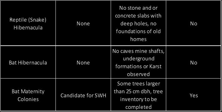
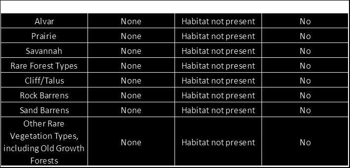
13 3.6 Significant Wildlife Habitat 188 Gordon Street, Guelph Environmental Impact Study Amended TOR October 2015 The significant wildlife habitat will be identified, mapped and evaluated as defined by the Natural Heritage Reference Manual (MNR 2010) based on criteria outlined by both the Significant Wildlife Habitat Technical Guide (MNR 2000) and/or the Significant Wildlife Habitat Schedule for Ecoregion 6E (MNR 2015) and the Official Plan, s6a.3 Natural Areas of the Natural Heritage System Policies. The potential presence of unrecorded species at risk will be assessed based on Ministry of Natural Resources and Forestry (MNRF) screening methodology. The Ministry of Natural Resources and Forestry has been contacted regarding information pertaining to requirements under the Endangered Species Act and Species at Risk Act. Any sensitive endangered species information gained through field studies will be shared with the City of Guelph in a timely manner. The conservation status of listed species will be determined based on assessments by the Committee on the Status of Endangered Wildlife in Canada (COSEWIC), the Committee on the Status of Species at Risk in Ontario (COSSARO) and the Provincial Natural Heritage Ranking System (S-Ranks). Local status will be defined by the City of Guelph s Natural Heritage Strategy Phase 2 Report. The following Table 3.1 is the completed Significant Wildlife Habitat Screening Table as provided in the City of Guelph EIS Draft Guidelines (2014). File No.: TRI_NS1415_078 Page 7


14 Table 3.1: Significant Wildlife Habitat Screening Table 188 Gordon Street, Guelph Environmental Impact Study Amended TOR October 2015 File No.: TRI_NS1415_078 Page 8


15 File No.: TRI_NS1415_078 Page Gordon Street, Guelph Environmental Impact Study Amended TOR October 2015


16 File No.: TRI_NS1415_078 Page Gordon Street, Guelph Environmental Impact Study Amended TOR October 2015

17 File No.: TRI_NS1415_078 Page Gordon Street, Guelph Environmental Impact Study Amended TOR October 2015


18 File No.: TRI_NS1415_078 Page Gordon Street, Guelph Environmental Impact Study Amended TOR October 2015
19 3.7 Habitat for Significant Species 188 Gordon Street, Guelph Environmental Impact Study Amended TOR October 2015 This section will evaluate and map all identified natural heritage features and areas, and associated ecological functions (in the study area, and in particularly on the subject property) and screen them against the in effect and applicable policies and guidelines to confirm whether or not they are considered significant in the City of Guelph. The City s Natural Heritage Strategy provides a list of locally significant species at a County or regional level and includes both flora and fauna. All significant species will be identified and form part of the analysis regarding habitat protection for these species. 4.0 DATA ANALYSIS The data obtained from the field investigations and review of background studies will be evaluated in order to determine sensitivity of features and functions. The criteria for determining significant features and functions (e.g. Significant Woodlands, Significant Wildlife Habitat, etc.) will be evaluated according to the following guiding documents, to ensure that legislative and policy requirements are being fulfilled: Natural Heritage Reference Manual Significant Wildlife Habitat Technical Guide Draft Significant Wildlife Habitat Ecoregion 6E Criterion Schedule City of Guelph Official Plan (consolidation September 2014) Section 6, Significant Natural Areas, outlines specific objectives, criteria for designation and policies for Significant Natural Areas and their buffers 4.1 Apply the Ontario Wetland Evaluation System The field data collected during our Natural Heritage Investigation will be used to determine scoring of the unevaluated wetland in the south west corner of the property. This scoring and assessment will then be provided to the Ministry of Natural Resources staff to determine if indeed the unevaluated wetland is provincially significant or a possible candidate for complexing with Halls Pond Provincially Significant Wetland. In addition it will be determined how the Grand River Conservation Authorities Wetland Policy applies to the unevaluated wetland. If the Halls Pond PSW Complex is determined, the best location for continuous data loggers will be considered for the monitoring program. File No.: TRI_NS1415_078 Page 13
20 188 Gordon Street, Guelph Environmental Impact Study Amended TOR October Identifying and Assessing the Impacts of the Proposal This section will identify and describe the significance of any adverse or positive environmental impacts of the subject property s proposed use. In particular, this section will: describe how the proposed development could affect the natural heritage features and functions of the subject property and adjacent natural heritage features and functions describe direct, indirect, induced, short-term, and long-term impacts with a particular emphasis on the following: o Tree/vegetation removal o Occupancy impacts resulting from increased use by people, including vegetation trampling, removal, litter, noise and additional invasive plant species 4.3 Avoiding Impacts and Evaluating Alternative Mitigation Measures Avoiding impacts and offering protection and buffers is preferred over mitigation. Our design approach will avoid impacts and protection measures will be recommended. Where adverse impacts are anticipated, a range of mitigation measures to reduce the magnitude or duration of the impact will be recommended. This section will also include the following: An analysis of setbacks that relate to the proposed land use and the abutting natural heritage features to be protected. A description of any proposed compensation or restoration plans for disturbed areas; A description of other mitigation or compensation measures proposed to eliminate, reduce or off-set impacts. The EIS will include consideration and evaluation of Low Impact Development (LID) alternatives Evaluation of Alternative Options Alternative options to avoid impacts will consider environmental constraints and sensitive habitats, seek to avoid impacts, then investigate protection measures. Compensation for impacts will be offered as an alternative option for consideration. This will be undertaken during discussions with review agencies and members of the project team to determine the most effective approach to protect/ maintain the NHS and fulfills the various planning, design and servicing requirements associated with the proposed development. File No.: TRI_NS1415_078 Page 14
21 5.0 POLICY REVIEW 188 Gordon Street, Guelph Environmental Impact Study Amended TOR October 2015 The relevant natural heritage provincial, regional, municipal and conservation authority policies and regulations will be reviewed. The proposed development plan will adhere to and respect the relevant natural heritage policies. The review will discuss the recommendations within the Hanlon Watershed Study and will compare the recommendations of EIS with the Hanlon Watershed Study Recommendations. 6.0 MONITORING Where appropriate, the EIS will include recommendations for long term management, conservation, enhancement, and/or the monitoring of significant environmental features and/or functions within the subject property and/or adjacent lands. The scope of any proposed monitoring plan and types of monitoring being proposed will be determined through assessment of features and ecological functions, sensitivity of features, and impacts resulting from the proposed development. If a complex with the Halls Pond PSW has been determined, the best location for continuous data loggers will be considered for the monitoring program. 7.0 RECOMMENDATIONS AND CONCLUSIONS This section of the EIS will address sub-sections ix and x of Section 6A.7.2 of the City of Guelph s Official Plan as revised by OPA 42. Specifically, the potential negative impacts associated with the proposed development will be summarized and the recommended measures to avoid or mitigate these impacts. Enhancements may also be suggested. Recommendations will be as specific as possible, and may include; a modification of the concept plan; a construction requirement or constraint; a requirement for appropriate buffers/setbacks or other environmental protection measures; and; an integral component of detailed designs or site plans, such as; o erosion and sediment control plan o restoration/enhancement measures o low impact development alternatives If appropriate, the EIS will also include recommendations for short and/or long-term monitoring to identify any negative impacts and inform the implementation of remedial measures. File No.: TRI_NS1415_078 Page 15
22 188 Gordon Street, Guelph Environmental Impact Study Amended TOR October 2015 Completed by: Klaryssa Lawrie, B.Sc., Dip. EMA, EPt Environmental Scientist Krysta-Leigh Johnston, B.A., Dip. EMA, EPt Environmental Consultant Reviewed by: Larry Freiburger, Dip. CEng, CEA, EP Director of Operations File No.: TRI_NS1415_078 Page 16
23 APPENDIX A BOUNDARY PLAN
24

 576-9723 Fax (519) 570-9589 www.")
25 N 43 40'55"E M PART LOT 11 CONCESSION 8 TOWNSHIP OF PUSLINCH CITY OF GUELPH COUNTY OF WELLINGTON N 45 25'30"W M N 45 25'30"W M N 44 31'45"E M N 44 31'10"E M N 44 31'23"E M GORDON STREET PART HECTARES N 45 22'20"W M N 45 26'50"W M PART HECTARES N 37 45'25"E M PART HECTARES N 44 31'23"E M N 45 25'30"W M Project Title: 1888 GORDON ST. GUELPH, ONARIO Sheet Title: BOUNDARY PLAN Date: N Project No: Figure: 1 N 43 24'35"E M N 43 24'35"E M 531 Wellington St. North Waterloo, Ontario, N2H 5L6 Tel (519) Fax (519)
26
27 APPENDIX B CONCEPTUAL MAPS OF DEVELOPMENT AREA
28


29 CLAIR RD. W. GORDON ST. FARLEY DR. HAWKINS DR. POPPY DR. E. Stacking Legend 7,500 sf - 8,000 sf floor plate 8,001 sf - 13,000 sf floor plate 13,001 sf - 20,000 sf floor plate townhouse frontage amenity structured parking Gordon St. Masterplan, Guelph, ON Context Plan - Option 2 Issue: Preliminary Concepts July 22nd 2015


30 Stacking Legend 7,500 sf - 8,000 sf floor plate 8,001 sf - 13,000 sf floor plate 13,001 sf - 20,000 sf floor plate townhouse frontage amenity structured parking Option 2 - Gross Floor Area Site Total SF Gordon St. Masterplan, Guelph, ON Axonometric View - Option 2 Issue: Preliminary Concepts July 22nd 2015


 121")

 Stacking")


31 Option 2 - Gross Floor Area GORDON ST. FARLEY DR. Site Total SF 3 levels 1 level parking structure 3 levels 3 levels 3 levels 5 levels 10 levels 14 levels (167,000 sf GFA) 132 units 18 towns 14 levels (208,000 sf GFA) 164 units 20 towns 10 levels 5 levels 8 levels (154,000 sf GFA) 121 units environmental area 26 towns public plaza 30 towns on (24,000 sf amenity space) Stacking Legend 7,500 sf - 8,000 sf floor plate 8,001 sf - 13,000 sf floor plate 13,001 sf - 20,000 sf floor plate townhouse frontage amenity structured parking Site Area: 3.1 ha Units per Hectare: 164 FSI: 2.0 Townhouse Units: 94 Apartment Units: 417 Total Units: 511 Gordon St. Masterplan, Guelph, ON Site Plan - Option 2 Issue: Preliminary Concepts July 22nd 2015
32
33 APPENDIX C ZONING BY-LAW MAP
34

35 HAWKINS DR HAWKINS DR R 0 KIRVAN CROSSING SINCL LYNC R.3B-7 DALLAN DR UR REFER TO THE TOWNSHIP OF PUSLINCH ZONING BY-LAW A CC-20 POPPY DR E CC-22 R.3B-20 R.4A-30 R.4A-47 R.3A-56 SC.1-55 P.1 WL CLAIR RD E WL WL P.1 R.1C R.1D R.1D R.3B-7 R.3A R.3B-7 R.4A-45 LOBSINGER LN DALLAN DR KAY CR POPPY DR E R.3B-7 R.3B-8 R.1C-24 P.1 R.1D R.3B-8 MCINTYRE CT R.2 R.2 R.1D R.2-10 R.3B-7 MCARTHUR CRES WL P.1 R.3B-7 3B-7 DEFINED AREA MAP NO Annexed Areas REFER TO THE TOWNSHIP OF PUSLINCH ZONING BY-LAW GORDON ST Surrounding DAMs LANDS ADJACENT TO PROVINCIALLY SIGNIFICANT WETLANDS (See Section 13.3) LANDS WITHIN THE SPECIAL POLICY AREA (See Section 12.4) MALTBY RD E LANDS WITH ONE OF THE FOLLOWING: LOCALLY SIGNIFICANT WETLANDS, SIGNIFICANT WOODLOTS, NATURAL CORRIDOR, OR LINKAGE (See Section 13.4) TOWNSHIP LANDS WITHIN OF PUSLINCH THE FLOOD FRINGE (See Section 12.3) ± M Produced by the City of Guelph Planning Services CITY OF GUELPH BY-LAW (1995) As last amended by By-law (2010) SCHEDULE 'A'
36
37 APPENDIX D STUDY AREA
38


39 PART LOT 11 CONCESSION 8 TOWNSHIP OF PUSLINCH CITY OF GUELPH COUNTY OF WELLINGTON Project Title: 1888 GORDON ST. GUELPH, ONARIO Sheet Title: STUDY AREA Date: Project No: TRI_NS1415_078 Figure: Wellington St. North Waterloo, Ontario, N2H 5L6 Tel (519) Fax (519)
July 9, Adèle Labbé Environmental Planner City of Guelph 1 Carden Street Guelph, Ontario N1H 3A1. Dear Ms. Labbé.
 July 9, 2014 Adèle Labbé Environmental Planner City of Guelph 1 Carden Street Guelph, Ontario N1H 3A1 Dear Ms. Labbé. Re: 132 Clair Road West EIS Terms of Reference North-South Environmental Inc. (hereafter,
Terms of Reference for Environmental Impact Study South End Recreation Complex 25 Poppy Drive, Guelph, Ontario
 Terms of Reference for Environmental Impact Study South End Recreation Complex 25 Poppy Drive, Guelph, Ontario Prepared for Applicant: City of Guelph Principal Author: Holly Dodds February 6, 2017 North-South
ENVIRONMENTAL ADVISORY COMMITTEE MEETING JANUARY 10, :00 P.M. MEETING ROOM C CITY OF GUELPH - CITY HALL 1 CARDEN STREET A G E N D A
 ENVIRONMENTAL ADVISORY COMMITTEE MEETING JANUARY 10, 2018 7:00 P.M. MEETING ROOM C CITY OF GUELPH - CITY HALL 1 CARDEN STREET 1) Call to Order 2) Roll Call and Certification of Quorum A G E N D A 3) Declarations
THE CORPORATION OF THE CITY OF WINDSOR Office of the City Solicitor Planning Department
 THE CORPORATION OF THE CITY OF WINDSOR Office of the City Solicitor Planning Department REPORT TO THE CITY OF WINDSOR PLANNING ADVISORY COMMITTEE DATE OF REPORT: August 19, 2010 SUBJECT: Official Plan
Meeting Agenda. City of Guelph. River Systems Advisory Committee. Agenda Items. Item 1, 2 and 3. Item 4 Ward to Downtown Pedestrian Bridge
 Meeting Agenda City of Guelph River Systems Advisory Committee September 19, 2018 City Hall, Meeting Room B From 4:00 to 6:00 p.m. Meeting Chair: Mariette Pushkar Agenda Items Welcome to all Item 1, 2
APPENDIX 1: SCOPED ENVIRONMENTAL IMPACT STATEMENT (EIS) FORM
 FORM") APPENDIX 1: SCOPED ENVIRONMENTAL IMPACT STATEMENT (EIS) FORM This form is intended for use by applicants (primarily private landowners) who need to conduct a Scoped EIS in support of minor development
APPENDIX 1: SCOPED ENVIRONMENTAL IMPACT STATEMENT (EIS) FORM This form is intended for use by applicants (primarily private landowners) who need to conduct a Scoped EIS in support of minor development
Infrastructure, Development and Enterprise Services. Natural Heritage Action Plan (NHAP) Project Initiation
 Project Initiation") Staff Report To Service Area Committee of the Whole Infrastructure, Development and Enterprise Services Date Monday, March 6, 2017 Subject Natural Heritage Action Plan (NHAP) Project Initiation Report
Staff Report To Service Area Committee of the Whole Infrastructure, Development and Enterprise Services Date Monday, March 6, 2017 Subject Natural Heritage Action Plan (NHAP) Project Initiation Report
TRCA Field Staking Protocol December 2016
 Page 1 of 6 TRCA Field Staking Protocol December 2016 This Protocol describes TRCA staff s current practice for field staking the physical top of bank, the physical toe of slope, and the limit of existing
Master Environmental Servicing Plan & Secondary Plan
 East Side Lands Stage 2 1 Master Environmental Servicing Plan & Secondary Plan Public Information Centre #1 June 16, 2016 Welcome! Today s Agenda Please sign in at the front desk. 5:30 pm 6:30 pm: Open
AMENDMENT NO. 30 TO THE OFFICIAL PLAN OF THE TOWN OF MILTON
 AMENDMENT NO. 30 TO THE OFFICIAL PLAN OF THE TOWN OF MILTON Subject: Boyne Survey Secondary Plan and Related Official Plan Amendments The following text and schedules constitute Amendment No. 30 to the
GEOMETRIC IMPROVEMENTS AND WATERMAIN LOOPING MUNICIPAL CLASS ENVIRONMENTAL ASSESSMENT
 GEOMETRIC IMPROVEMENTS AND WATERMAIN LOOPING MUNICIPAL CLASS ENVIRONMENTAL ASSESSMENT Veterans Way (previously Powerline Road) and Klondike Park Road Wasaga Beach Welcome Please sign in Take a comment
ENVIRONMENTAL ADVISORY COMMITTEE WEDNESDAY, JANUARY 11, 2017 AT 7:00 P.M. CITY HALL MEETING ROOM C MINUTES
 ENVIRONMENTAL ADVISORY COMMITTEE WEDNESDAY, JANUARY 11, 2017 AT 7:00 P.M. CITY HALL MEETING ROOM C MINUTES Present: C. Oakes (Chair) M. Wilson A. Baron A. Miller A. Singh L. Todd L. Renzetti Regrets: City:
APPENDIX 1. Long Range Planning and the Vision for the Future of the Town
 APPENDIX 1 Long Range Planning and the Vision for the Future of the Town Long Range Planning and the Vision for the Future of the Town Given the requirements of the Provincial Policy Statement and Growth
TERRESTRIAL NATURAL HERITAGE SYSTEM STRATEGY APPENDIX F: MODEL POLICIES FOR THE IMPLEMENTATION OF THE TARGET TERRESTRIAL NATURAL HERITAGE SYSTEM
 TERRESTRIAL NATURAL HERITAGE SYSTEM STRATEGY APPENDIX F: MODEL POLICIES FOR THE IMPLEMENTATION OF THE TARGET TERRESTRIAL NATURAL HERITAGE SYSTEM C H A P T E R 1 M O D E L P O L I C I E S F O R I M P L
Appendix A: List of Background Sources Reviewed
 Appendix A: List of Background Sources Reviewed Aboud and Associates Inc. (2010). 1897 Gordon Street (Bird Property) - Environmental Impact Study and Tree Conservation Plan (2nd Submission). Prepared
PLANNING JUSTIFICATION REPORT
 PLANNING JUSTIFICATION REPORT 556, 560 and 576 Conservation Drive 2115881 Ontario Limited City of Waterloo, Regional Municipality of Waterloo Zoning By-law Amendment Draft Plan of Subdivision July 2016
Bressa Developments Limited. Planning Justification Report. Revised Draft Plan of Subdivision and Zoning By-Law Amendment
 Bressa Developments Limited Revised Draft Plan of Subdivision and Zoning By-Law Amendment Planning Justification Report Part of Lots 7 & 8 Concession 1, North of Dundas Street Town of Oakville September,
Submitted to the City of Guelph. FINAL REPORT March 2005
 Submitted to the City of Guelph City of Guelph Natural Heritage Strategy Phase 1: Terrestrial Inventory Design & Defining Locally Significant Natural Areas Tree preservation on Grange Hill Torrance Creek
CITY OF VAUGHAN EXTRACT FROM COUNCIL MEETING MINUTES OF NOVEMBER 15, 2016
 Item 11, Report No. 38, of the Committee of the Whole, which was adopted without amendment by the Council of the City of Vaughan on November 15, 2016. Regional Councillor Di Biase declared an interest
Figure 1- Site Plan Concept
 Figure 1- Site Plan Concept Parking will be provided underground on three levels at rate of 1.0 space/ unit; this rate includes all visitors parking. MMM Group has prepared a parking assessment (April,
PORT WHITBY COMMUNITY
 PORT WHITBY COMMUNITY SECONDARY PLAN UPDATE COMMUNITY IMPROVEMENT PLAN URBAN DESIGN GUIDELINES September 2015 DRAFT PROPOSED AMENDMENT NUMBER # to the Whitby Official Plan PURPOSE: The intent of this Amendment
240 and 242 Finch Avenue West Zoning By-law Amendment Application Preliminary Report
 REPORT FOR ACTION 240 and 242 Finch Avenue West Zoning By-law Amendment Application Preliminary Report Date: March 1, 2019 To: North York Community Council From: Director, Community Planning, North York
11. BALLANTRAE-MUSSELMAN LAKE AND ENVIRONS SECONDARY PLAN
 11. BALLANTRAE-MUSSELMAN LAKE AND ENVIRONS SECONDARY PLAN 11.1 PURPOSE The Ballantrae-Musselman Lake and Environs Secondary Plan Area includes two small existing settlement areas, Ballantrae and Musselman
Township of Adjala-Tosorontio Official Plan Review. Natural Heritage
 Township of Adjala-Tosorontio Official Plan Review 13 Natural Heritage Introduction What is an Official Plan? An official plan is a municipal policy document which sets out the community s vision and strategies
F2. Draft Archaeological and Cultural Heritage Net Effects Analysis & Comparative Evaluation Report
 F2. Draft Archaeological and Cultural Heritage Net Effects Analysis & Comparative Evaluation Report Clean Harbors Canada Inc. Lambton Landfill Expansion Environmental Assessment Draft Archaeological and
BLACK/HARMONY/FAREWELL CREEK WATERSHED EXISTING CONDITIONS REPORT CHAPTER 5 IMPERVIOUS SURFACES
 BLACK/HARMONY/FAREWELL CREEK WATERSHED EXISTING CONDITIONS REPORT CHAPTER 5 IMPERVIOUS SURFACES Draft November 2009 TABLE OF CONTENTS 1.0 INTRODUCTION... 3 2.0 STUDY AREA AND SCOPE... 4 3.0 METHODOLOGY...
Town of Newmarket 395 Mulock Drive P.O. Box 328, Newmarket, Ontario, L3Y 4X7. Website: newmarket.ca Phone:
 Town of Newmarket 395 Mulock Drive P.O. Box 328, Newmarket, Ontario, L3Y 4X7 Email: info@newmarket.ca Website: newmarket.ca Phone: 905-895-5193 Natural Heritage System Boundary Refinement: Vacant Lot West
Rowntree Mill Road Zoning and Plan of Subdivision Applications Final Report
 STAFF REPORT ACTION REQUIRED 148-156 Rowntree Mill Road Zoning and Plan of Subdivision Applications Final Report Date: March 13, 2007 To: From: Wards: Reference Number: Etobicoke York Community Council
PLANNING RATIONALE. Shadow Ridge Estates Subdivision, Phase Two. In Support of a Proposed Zoning By-Law Amendment. Report Number: R
 PLANNING RATIONALE Shadow Ridge Estates Subdivision, Phase Two In Support of a Proposed Zoning By-Law Amendment Report Number: R-2011-222 Prepared for: Donwel Land Inc. Prepared by: Novatech Engineering
3-2 Environmental Systems
 3-2 Environmental Systems 3.0 ENVIRONMENTAL SYSTEMS CONTENTS 3.1 GREENWAY SYSTEM 3.1.1 General Policies 3.1.2 Natural Heritage Network 3.1.3 Natural Heritage Network Enhancement Lands 3.1.4 Rouge Watershed
Leonard s Beach Secondary Plan (Alcona North) Official Plan Amendment
 Official Plan Amendment") Leonard s Beach Secondary Plan (Alcona North) Official Plan Amendment Public Meeting Presentation August 14, 2013 Note: This document is for presentation purposes only. Please see Staff Report DSR-135-13
Leonard s Beach Secondary Plan (Alcona North) Official Plan Amendment Public Meeting Presentation August 14, 2013 Note: This document is for presentation purposes only. Please see Staff Report DSR-135-13
URBAN DESIGN BRIEF Gordon Street City of Guelph. Prepared on behalf of Ontario Inc. March 25, Project No. 1507
 URBAN DESIGN BRIEF 1131 Gordon Street City of Guelph Prepared on behalf of 1876698 Ontario Inc. March 25, 2016 Project No. 1507 423 Woolwich Street, Suite 201, Guelph, Ontario, N1H 3X3 Phone (519) 836-7526
4. What are the goals of the Kawarthas, Naturally Connected project? 7. What are watersheds and why are they being used as the project boundaries?
 Frequently Asked Questions (FAQs) 1. What are Natural Heritage Systems (NHS)? 2. Why are they important? 3. Which areas of the province have undertaken NHS projects? 4. What are the goals of the Kawarthas,
APPENDIX F: EXTERNAL APPROVALS
 1.0 RESPONSIBILITIES When the City is constructing the Park or Open Space Development lands (OPTION I), after the subdivision construction process is completed by the Developer, Open Space Development
~!VAUGHAN NOV Z November 21, Mr. Denis Kelly, Regional Clerk The Regional Municipality of York Yonge Street Newmarket, ON L3Y 6Z1
 ~!VAUGHAN NOV Z 5 2016 November 21, 2016 Mr. Denis Kelly, Regional Clerk The Regional Municipality of York 17250 Yonge Street Newmarket, ON L3Y 6Z1 Dear Mr. Kelly: RE: NEW KIRBY GO STATION IN BLOCK 27
Environment and Sustainability. Environment and Sustainability
 4 Environment and Sustainability Environment and Sustainability ENVIRONMENT AND SUSTAINABILITY 4.1 CLIMATE CHANGE AND AIR QUALITY... 4-5 4.1.1 OBJECTIVES... 4-6 4.1.2 POLICIES... 4-6 4.2 NATURAL HERITAGE
Planning Justification Report
 Planning Justification Report Application for Draft Plan of Subdivision, Official Plan Amendment and Zoning Bylaw Amendment for Lift of Hold Proposed Residential Development Part of Lots 34 & 35, Concession
CONTENTS 8.0 LAND USE 8.1 GENERAL LAND USE 8.2 RESIDENTIAL 8.3 MIXED USE 8.4 COMMERCIAL 8.5 EMPLOYMENT LANDS
 8-2 Land Use 8.0 LAND USE CONTENTS 8.1 GENERAL LAND USE 8.1.1 Uses provided for in all Land Use Designations 8.1.2 Uses prohibited in Hazardous Lands, Hazardous Sites and Special Policy Areas 8.1.3 Uses
The lands identified as Residential Areas on Schedule A1, Urban Structure, represent the areas that provide for stable residential communities.
 Livable Oakville Part D: Land Use Designations and Policies 11. RESIDENTIAL 11.1 General The lands identified as Residential Areas on Schedule A1, Urban Structure, represent the areas that provide for
ENBRIDGE GAS DISTRIBUTION INC. Proposed Relocation for Ninth Line, Markham and Whitchurch-Stouffville. Environmental Screening Report
 Page 1 of 18 ENBRIDGE GAS DISTRIBUTION INC. Proposed Relocation for Ninth Line, Markham and Whitchurch-Stouffville Environmental Screening Report July 2011 Page 2 of 18 Table of Contents 1.0 INTRODUCTION
HURON COMMUNITY PLAN
 CITY OF KITCHENER DEPARTMENT OF DEVELOPMENT AND TECHNICAL SERVICES PD 94/7 HURON COMMUNITY PLAN Recommended by Planning and Economic Development Committee: October 31, 1994 Adopted by Kitchener City Council:
A Guide to Open Space Design Development in Halifax Regional Municipality
 A uide to Open Space Design Development in Halifax Regional Municipality May 2007 1 Introduction Pursuant to Section 3.5 of the Regional Municipal Planning Strategy (RMPS), subdivision of land may proceed
City of Grande Prairie Development Services Department KENNEDY DEVELOPMENTS LTD. OUTLINE PLAN OP-09-01
 City of Grande Prairie Development Services Department KENNEDY DEVELOPMENTS LTD. OUTLINE PLAN OP-09-01 July 27, 2009 TABLE OF CONTENTS 1.0 Introduction... 1 1.1 Plan Area Location & Context... 1 1.2 Ownership
Bostwick Road. Municipal Class Environmental Assessment. Public Information Centre #2 June 14, City of London
 Bostwick Road Municipal Class Environmental Assessment Public Information Centre #2 June 14, 2017 Welcome! Welcome to the 2 nd Public Information Centre for the. Representatives from the and the consulting
and Richmond Street West - Official Plan Amendment Application - Preliminary Report
 STAFF REPORT ACTION REQUIRED 822-838 and 860-862 Richmond Street West - Official Plan Amendment Application - Preliminary Report Date: August 14, 2017 To: From: Wards: Reference Number: Toronto and East
Great Lakes Conservation Blueprint for Terrestrial Biodiversity on the Canadian Shield
 Great Lakes Conservation Blueprint for Terrestrial Biodiversity on the Canadian Shield Bonnie L. Henson 1, Kara E. Brodribb 2 and John L. Riley 3 1 Ontario Ministry of Natural Resources 2,3 The Nature
STORM SEWER OUTFALLS AND CONNECTING OUTFALL CHANNELS. General Submission Requirements
 COMPLETE APPLICATION CHECKLIST Jan 2016 STORM SEWER OUTFALLS AND CONNECTING OUTFALL CHANNELS The following checklist has been compiled to assist the applicant in preparing their application for approval
Urban Design Brief to 1557 Gordon Street & 34 Lowes Road West
 Urban Design Brief 1533 to 1557 Gordon Street & 34 Lowes Road West Reid s Heritage Homes Ltd. & 883928 Ontario Ltd. and RHH Property Management Ltd. City of Guelph Zoning By-law Amendment November 2017
Ashbridges Bay Erosion and Sediment Control Project
 Ashbridges Bay Erosion and Sediment Control Project Project Brief Overview Toronto and Region Conservation Authority, in partnership with the City of Toronto, intends to carry out remedial erosion control
Highway 2, Courtice
 1475-1495 Highway 2, Courtice Public Information Centre January 11 th, 2017 6:30pm Faith United Church 1778 Nash Road, Courtice ON Municipality of Clarington File No. COPA 2016.0004 & ZBA 2016-0024 Team
Planning Justification Report for 1888 Gordon Street Guelph, Ontario
 Planning Justification Report for 1888 Gordon Street Guelph, Ontario 161401285 Prepared for: The City of Guelph on behalf of Tricar Developments Inc. 3800 Colonel Talbot Road London ON N6P 1H5 Prepared
LAURENTIAN WEST COMMUNITY PLAN
 CITY OF KITCHENER DEPARTMENT OF PLANNING AND DEVELOPMENT PD 123/91 LAURENTIAN WE COMMUNITY PLAN Phases 1 and 2 Recommended by Planning Committee: June 14 th 1993 Adopted by Kitchener City Council: June
FORMER CANADIAN FORCES BASE (CFB) ROCKCLIFFE SECONDARY PLAN. Official Plan Amendment XX to the Official Plan for the City of Ottawa
 ROCKCLIFFE SECONDARY PLAN. Official Plan Amendment XX to the Official Plan for the City of Ottawa") FORMER CANADIAN FORCES BASE (CFB) ROCKCLIFFE SECONDARY PLAN Official Plan Amendment XX to the Official Plan for the City of Ottawa 1 INDEX THE STATEMENT OF COMPONENTS PART A THE PREAMBLE PAGE Purpose...
FORMER CANADIAN FORCES BASE (CFB) ROCKCLIFFE SECONDARY PLAN Official Plan Amendment XX to the Official Plan for the City of Ottawa 1 INDEX THE STATEMENT OF COMPONENTS PART A THE PREAMBLE PAGE Purpose...
Richmond Hill Official Plan PART II SECONDARY PLANS
 9 N O R T H L E S L I E Richmond Hill Official Plan PART II SECONDARY PLANS TABLE OF CONTENTS 9.0 THE NORTH LESLIE SECONDARY PLAN 9-3 Basis The Development Concept 9.1 Introduction 9-4 9.2 Purpose 9-4
2900 Steeles Avenue East at Don Mills Road in the Town of Markham
 STAFF REPORT INFORMATION ONLY 2900 Steeles Avenue East at Don Mills Road in the Town of Markham Date: January 23, 2008 To: From: Wards: Reference Number: North York Community Council Director, Community
Master Environmental Servicing Plan & Secondary Plan
 1 East Side Lands Stage 2 Master Environmental Servicing Plan & Secondary Plan Public Consultation Centre #4 March 20, 2018 Welcome! Today s Agenda Please sign in at the registration table. 6:00 pm 6:30
PLANNING JUSTIFICATION REPORT
 PLANNING JUSTIFICATION REPORT 55 DELHI STREET CITY OF GUELPH PREPARED FOR: VESTERRA PROPERTY MANAGEMENT PREPARED BY: LABRECHE PATTERSON & ASSOCIATES INC. SCOTT PATTERSON, BA, CPT, MCIP, RPP PRINCIPAL,
Stantec Consulting Ltd.
 Stantec Consulting Ltd. Natural Heritage Impact Study March 2013 155 Glenforest Road, Cambridge Ontario N3C 1V6 519-658- 6085 Table of Contents 1.0 INTRODUCTION... 3 2.0 ENVIRONMENTAL DESCRIPTIONS... 11
5 TOWN OF MARKHAM OFFICIAL PLAN AMENDMENT NO. 144 MILLIKEN MAIN STREET SECONDARY PLAN
 5 TOWN OF MARKHAM OFFICIAL PLAN AMENDMENT NO. 144 MILLIKEN MAIN STREET SECONDARY PLAN The Planning and Economic Development Committee recommends the following: 1. The communication from Brendan O Callaghan,
280 Manse Road - Official Plan Amendment, Zoning Amendment, Draft Plan of Subdivision Applications - Preliminary Report
 STAFF REPORT ACTION REQUIRED 280 Manse Road - Official Plan Amendment, Zoning Amendment, Draft Plan of Subdivision Applications - Preliminary Report Date: March 11, 2014 To: From: Wards: Reference Number:
APPLICATION BRIEFING Prepared For: Submitted by: Date: Subject:
 Planning & Development APPLICATION BRIEFING Prepared For: Submitted by: Date: Subject: Planning Advisory Committee Jason Fox, Director of Planning & Development Development Agreement application by Godfrey
Public Information Centre. Welcome
 Transportation Improvements from the Beaver Creek Bridge to the Entrance of Santa s Village District of Muskoka Municipal Class Environmental Assessment Welcome Please sign in Take a comment sheet Staff
Design Specifications & Requirements Manual
 11 PARKS & OPEN SPACES 11.1 DEFINITIONS... 1 11.1.1 Neighbourhood Parks... 1 11.1.2 District Parks... 1 11.1.3. Sport Parks... 1 11.1.4 Urban Parks... 1 11.1.5 Civic Spaces... 1 11.1.6 Open Space System...
MAYFIELD WEST SECONDARY PLAN PHASE 2
 MAYFIELD WEST SECONDARY PLAN PHASE 2 Council Information Workshop February 16, 2010 Draft Preferred Land Use Plan TOWN OF CALEDON PLANNING & DEVELOPMENT DEPARTMENT Workshop Agenda TOWN OF CALEDON 1. Welcome
Draft Rhode Island Stormwater Design and Installation Standards Manual
 Draft Rhode Island Stormwater Design and Installation Standards Manual Summary The May 2009 Public Review Draft version of the RI Stormwater Design and Installation Standards Manual consists of approximately
APPENDIX K WINDSOR OFFICIAL PLAN
 CEAA ENVIRONMENTAL ENVIRONMENTAL IMPACT ASSESSMENT AMBASSADOR BRIDGE ENHANCEMENT PROJECT Replacement Span and Plaza Expansion APPENDIX K WINDSOR OFFICIAL PLAN Avalon Consulting Professionals of Ontario,
Once Upon a Gravel Pit: Reconnecting Floodplain through Aggregate Extraction
 Once Upon a Gravel Pit: Reconnecting Floodplain through Aggregate Extraction 5 th International Conference on Natural Channel Systems September 26, 2016 1 The Story of Snyder s Flats Historical influences
Bostwick Road. Municipal Class Environmental Assessment. October 13, City of London. Bostwick Road Municipal Class Environmental Assessment
 Bostwick Road Municipal Class Environmental Assessment October 13, 2016 Welcome! Welcome to the first Public Information Centre for the Bostwick Road Municipal Class Environmental Assessment. Representatives
A Landowner s Guide to Creating Woodland Pools for Amphibians and Other Wildlife
 Cornell Department of Natural Resources Conservation Education Program Fact Sheet Kristi L. Sullivan and Stephen J. Morreale A Landowner s Guide to Creating Woodland Pools for Amphibians and Other Wildlife
4780 Eglinton Avenue West - Zoning By-law Amendment and Draft Plan of Subdivision Applications - Preliminary Report
 STAFF REPORT ACTION REQUIRED 4780 Eglinton Avenue West - Zoning By-law Amendment and Draft Plan of Subdivision Applications - Preliminary Report Date: May 29, 2014 To: From: Wards: Reference Number: Etobicoke
13. VANDORF-PRESTON LAKE SECONDARY PLAN 13.1 INTRODUCTION
 13. VANDORF-PRESTON LAKE SECONDARY PLAN 13.1.1 Purpose 13.1 INTRODUCTION The Vandorf-Preston Lake Secondary Plan establishes the principles, objectives and general policies, as well as specific strategies
LAND USE ASSESSMENT REPORT (LUAR) PROPOSED AFFORDABLE HOUSING COMPLEX MAIN ROAD PDE FILE NUMBER: REZ
 PROPOSED AFFORDABLE HOUSING COMPLEX MAIN ROAD PDE FILE NUMBER: REZ") LAND USE ASSESSMENT REPORT (LUAR) PROPOSED AFFORDABLE HOUSING COMPLEX 560-564 MAIN ROAD PDE FILE NUMBER: REZ13-00008 PREPARED FOR P.O. BOX 908 ST. JOHN'S, NL CANADA A1B 4C4 PROPONENT BROOKSIDE DEVELOPMENTS
LAND USE ASSESSMENT REPORT (LUAR) PROPOSED AFFORDABLE HOUSING COMPLEX 560-564 MAIN ROAD PDE FILE NUMBER: REZ13-00008 PREPARED FOR P.O. BOX 908 ST. JOHN'S, NL CANADA A1B 4C4 PROPONENT BROOKSIDE DEVELOPMENTS
6 PORT SYDNEY SETTLEMENT AREA
 Section 6 Port Sydney Page 61 6 PORT SYDNEY SETTLEMENT AREA 6.1 Basis and Principles Village of Port Sydney Waterfront Community Existing Services 6.1.1 Port Sydney is an historic settlement that has developed
TRCA Roles and Responsibilities in Planning and Development
 TRCA Roles and Responsibilities in Planning and Development Regional Watershed Alliance November 14, 2018 Laurie Nelson, MCIP, RPP Associate Director, Planning and Policy Outline Roles and Legislation
Planning & Development. Background. Subject Lands
 Planning & Development APPLICATION BRIEFING Prepared For: Planning Advisory Committee Submitted by: Jason Fox, Director of Planning & Development Date: Subject: Development Agreement Application by Brentwood
Circular L8/08 2 September Water Services Investment and Rural Water Programmes Protection of Natural Heritage and National Monuments
 Circular L8/08 2 September 2008 Water Services Investment and Rural Water Programmes Protection of Natural Heritage and National Monuments 1. The purpose of this Circular is to provide local authorities
Lower Don River West Remedial Flood Protection Project TABLE OF CONTENTS. Page. Executive Summary
 TABLE OF CONTENTS Page Executive Summary 1.0 INTRODUCTION...1-1 1.1 Purpose of the Undertaking...1-1 1.2 Study Area Description...1-1 1.3 Description of the Undertaking...1-1 1.4 Rationale for the Undertaking...1-2
Burloak Drive Grade Separation
 Burloak Drive Grade Separation Transit Project Assessment Process Public Meeting #1 March 30, 2017 GO Lakeshore West Service Plan Weekday Rush Hour 15-minute, two-way service between Aldershot* and Union
Sustainable Natural Environment Wetlands
 Town of Huntsville Official Plan Review - POLICY BACKGROUND PAPER Sustainable Natural Environment Wetlands BACKGROUND: Wetlands are an important natural resource. The ecological, social and economic benefits
Wingerworth, Chesterfield. February Surveyor: James Porter
 Report Wingerworth, Chesterfield February 2014 Surveyor: James Porter (Natural England Licence Number: CLS00241 Contents Contents Notice to readers 1.0 Introduction Background Information Site Description
Rapid Transit Implementation Working Group September 14, 2017
 Rapid Transit Implementation Working Group September 14, 2017 BACKGROUND Council approved the Rapid Transit Master Plan and Updated Business Case on July 25, 2017. Approval of the RTMP confirmed the BRT
TO BE COMPLETED BY APPLICANT
 Planning Division #200-2564 Shaughnessy Street Port Coquitlam BC V3C 3G4 Tel 604.927.5442 Fax 604.927.5404 Email planning@portcoquitlam.ca Application for Watercourse Development Permit Watercourse Development
CHAIR AND MEMBERS PLANNING & ENVIRONMENT COMMITTEE JOHN M. FLEMING MANAGING DIRECTOR, PLANNING AND CITY PLANNER
 TO: FROM: SUBJECT: CHAIR AND MEMBERS PLANNING & ENVIRONMENT COMMITTEE JOHN M. FLEMING MANAGING DIRECTOR, PLANNING AND CITY PLANNER APPLICATION BY: OLD OAK PROPERTIES INC. 2300 RICHMOND STREET PUBLIC PARTICIPATION
Commercial Development Proposal Tenth Line Road. Planning Rationale Report. Minto Developments Inc.
 Commercial Development Proposal 2168 Tenth Line Road Report September 2015 Prepared for Minto Developments Inc. Paquette Planning Associates Ltd. 56 Hutchison Avenue Ottawa, Ontario K1Y 4A3 PH: 613-722-7217
Appendix I. Checklists
 Appendix I Checklists Town of Greenwich Drainage Manual Department of Public Works - Engineering Division Town Hall - 101 Field Point Road, Greenwich, CT 06836-2540 Phone 203-622-7767 - Fax 203-622-7747
Official Plan Review: Draft Built Form Policies
 PG.30.1 REPORT FOR ACTION Official Plan Review: Draft Built Form Policies Date: May 15, 2018 To: Planning and Growth Management Committee From: Chief Planner and Executive Director, City Planning Division
5959 Yonge Street Rezoning Application - Preliminary Report
 STAFF REPORT ACTION REQUIRED 5959 Yonge Street Rezoning Application - Preliminary Report Date: February 23, 2011 To: From: Wards: Reference Number: North York Community Council Director, Community Planning,
Design Specifications & Requirements Manual
 11 PARKS & OPEN SPACES 11.1 DEFINITIONS... 1 11.1.1 Neighbourhood Parks... 1 11.1.2 District Parks... 1 11.1.3. Sport Parks... 1 11.1.4 Urban Parks... 1 11.1.5 Civic Spaces... 1 11.1.6 Open Space System...
C ity of Grande Prairie Development Services Department
 C ity of Grande Prairie Development Services Department FAIRWAY DEVELOPMENT OUTLINE PLAN OP 08 09 Approved April 6, 2009 Prepared by: Focus Corporation Table of Contents 1.0. Introduction 2 3 1.1. Plan
PepsiCo R & D Facility Expansion Town of Mount Pleasant, Westchester County, NY Draft Environmental Impact Statement Scoping Outline
 PepsiCo R & D Facility Expansion Town of Mount Pleasant, Westchester County, NY Draft Environmental Impact Statement Scoping Outline 10-17-2016 This document identifies the issues to be addressed in the
Highway 427 Industrial Secondary Plan Area 47 Schedule C Class Environmental Assessment For Arterial Roadways
 Welcome to Pubic Information Centre #1 Highway 427 Industrial Secondary Plan Area 47 Schedule C Class Environmental Assessment For Arterial Roadways Welcome to Open House # 1 Tonight, we invite you to.
B R I E F A p p e n d i x A : F i g u r e s
 HALTON MUNICIPALITIES BRIEF: APPENDIX A 1 B R I E F A p p e n d i x A : F i g u r e s 2 0 1 6 Halton Municipalities Regional Municipality of Halton Corporation of the City of Burlington Corporation of
8 Oak Street - Official Plan and Zoning By-law Amendment Application - Preliminary Report
 STAFF REPORT ACTION REQUIRED 8 Oak Street - Official Plan and Zoning By-law Amendment Application - Preliminary Report Date: March 17, 2014 To: From: Wards: Reference Number: Planning and Growth Management
Director, Community Planning, Etobicoke York District
 STAFF REPORT April 25, 2006 To: From: Subject: Etobicoke York Community Council Director, Community Planning, Etobicoke York District Refusal Report Rezoning Application 04 203855 WET 07 OZ Plan of Subdivision
CITY OF NIAGARA FALLS. By-law No
 CITY OF NIAGARA FALLS By-law No. 2018- A by-law to provide for the adoption of Amendment No. 128 to the City of Niagara Falls Official Plan (OPA #128). THE COUNCIL OF THE CORPORATION OF THE CITY OF NIAGARA
The Corporation of the TOWN OF MILTON
 Report to: From: Chair & Members of the Administration & Planning Standing Committee W.F. Mann, Director of Planning and Development Date: April 16, 2012 PD 022-12 (Z19/11) Subject: Technical Report Proposed
MAYFIELD WEST SECONDARY PLAN PHASE 2
 MAYFIELD WEST SECONDARY PLAN PHASE 2 Public Open House #3 February 25, 2010 Draft Preferred Land Use Scenario TOWN OF CALEDON PLANNING & DEVELOPMENT DEPARTMENT Open House Agenda TOWN OF CALEDON 1. Welcome
DRAFT MAP AMENDMENT FLU 04-4
 DRAFT MAP AMENDMENT FLU 04-4 SW 24 TH AVENUE ROADWAY CORRIDOR The University of Florida participates with the Metropolitan Transportation Planning Organization (MTPO) in its responsibilities for the continuing,
Heritage Road Improvements from Steeles Avenue to Rivermont Road
 The Corporation of the City of Brampton Heritage Road Improvements from Steeles Avenue to Rivermont Road Class Environmental Assessment Study (Schedule C) September 19, 2013 The Corporation of the City
Toronto Complete Streets Guidelines
 Toronto Complete Streets Guidelines 108 110 7.1 Green Infrastructure Design Principles 112 7.2 Context-Sensitive Green Streets 114 7.3 Key Green Street Elements Green infrastructure refers to natural and