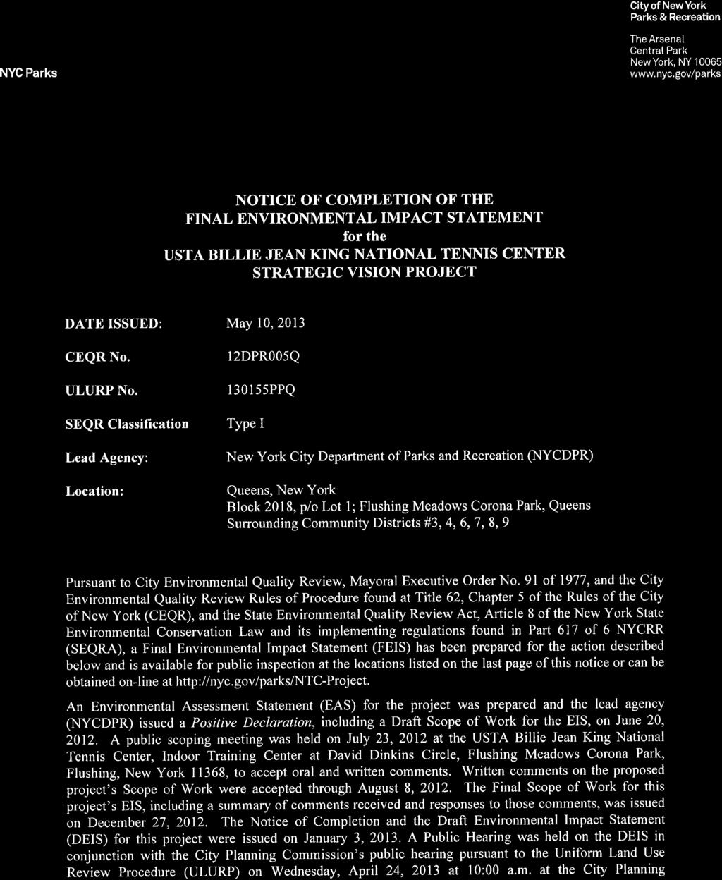
A. PROJECT IDENTIFICATION
|
|
|
- Ralph Harrington
- 6 years ago
- Views:
Transcription

1
2 Commission, Spector Hall, 22 Reade Street, New York, New York 10007, to accept oral and written comments on the DEIS. Written comments on the DEIS were accepted through May 6, A. PROJECT IDENTIFICATION NYCDPR, in coordination with USTA National Tennis Center, Incorporated (USTA), is seeking a number of discretionary actions in connection with proposed improvements and an expansion to the facilities at the USTA Billie Jean King National Tennis Center (NTC), located in Flushing Meadows Corona Park in Queens. These improvements collectively are known as the NTC Strategic Vision (the proposed project). The NTC is located on a portion of Queens Block 2018, Lot 1, on park land leased by DPR to USTA. The leased site is bounded to the north by the railway tracks of the LIRR s Port Washington line; United Nations Avenue North to the south; the Passerelle Building (connects LIRR s Mets-Willets Point station to the Metropolitan Transportation Authority [MTA] s 7 train station, and Citi Field, the New York Mets baseball stadium) and Path of the Americas to the east; and Grand Central Parkway to the west. The 42-acre NTC is one of the world s largest public recreational tennis facilities. For 11 months of the year, its facilities are open to the public for indoor and outdoor tennis; USTA maintains the facilities yearround. The NTC is also host to the US Open, one of the sport s four Grand Slam championship tennis tournaments. The event is staged during a two-week period around the beginning of September, is attended by approximately 700,000 spectators, and is broadcast worldwide. The proposed project would improve the NTC site plan, circulation, visitor amenities, and landscaping, and would include construction of two new stadiums to replace the existing Louis Armstrong Stadium (Stadium 2) in the same location, and Grandstand Stadium (Stadium 3) in a new location at the southwest corner of the NTC site, as well as possible improvements to Arthur Ashe Stadium (Stadium 1). The proposed project would also include modifications to tournament courts and ancillary buildings, the construction of two new parking garages, the relocation of a connector road, and pedestrian enhancements. To accommodate the proposed project, 0.94 acres of land would be added to the NTC site, including 0.68 acres of park land that would be alienated, and 0.26 acres of previously alienated park land associated with the connector road that is outside the current lease. Replacement park land in two parcels totaling 1.56 acres would be surrendered from within the current boundaries of the NTC in connection with the alienation of the 0.68-acre parcel. Just to the south of the NTC, the relocated connector road and new sidewalks would be built on an approximately 0.3-acre area. Improvements to park features in Flushing Meadows Corona Park would also be provided, as described in greater detail below. If approved, the proposed project is expected to be completed by The FEIS analyzes the reasonable worst-case scenario for the proposed project as described above. B. PURPOSE AND NEED The purpose of the proposed project is to sustain the long-term viability of the NTC as a world-class spectator venue and outstanding public recreational facility. It would result in a much needed improvement to the visitor experience and provide substantial long-term economic benefits to Queens, New York City, and the region. BACKGROUND The US Open, which dates back to 1881, moved to its current site in Flushing Meadows Corona Park in 1978, making its facilities available to the public 11 months of the year. In 1993, the NTC site expanded from 21.6 acres to approximately 42.2 acres to allow for the construction of a new 23,500-seat stadium (Arthur Ashe Stadium), completed in The 1993 expansion required alienation of park land following review by the City through its Uniform Land Use Review Procedure (ULURP). The tennis center was renamed the USTA Billie Jean King National Tennis Center in Today, the NTC is one of the largest public tennis facilities in the world. The US Open attracts over 700,000 spectators annually and generates substantial economic benefits in New York City. 2
3 The nearly 900-acre Flushing Meadows Corona Park Queens largest public park was created for the World s Fair. It offers a variety of event-oriented recreational activities, as well as lawns, fields, and playgrounds for active and passive recreation. Portions of this park (but not the NTC) have been improved with funds from the Federal Land and Water Conservation Fund (LWCF) Act, and much of the park, including the NTC, is subject to LWCF requirements. The health, welfare and recreational public purposes of the NTC have been recognized by the New York State Legislature and the New York City Council in the State legislation and City Administrative Code provisions that govern the NTC lease, as well as by the U.S. Department of the Interior, National Park Service (NPS), which determined in 1993 that the expansion and renovation of the NTC is consistent with the LWCF grant-in-aid manual requirements governing Flushing Meadows Corona Park. The USTA and the affiliated United States Tennis Association promote and develop tennis in the community through a wide range of programs. More than 100,000 participants of all ages, the majority of whom are from the local Queens community, participate in hundreds of community tennis programs at the NTC each year. The NTC is home court for more than 70 New York City high schools and colleges and a number of diverse organizations seeking a place to play tennis or host tournaments. USTA offers court rentals to the public at rates calculated under USTA s lease with the City. The grounds of the NTC are also open 11 months of the year to visitors of Flushing Meadows Corona Park, free of charge. Approximately $1 million is spent each year for other United States Tennis Association tennis programs in New York City as well, including grants for free tennis programs, free equipment, court refurbishments, and scholarships, all supported by revenues from the US Open. Through its flagship event, the US Open, USTA has significant world-wide reach and economic impact on the City of New York. Approximately 42 percent of US Open patrons come from outside the New York metro area, including 14 percent from outside the US. During the US Open, attendees, players, media, sponsors and staff generate substantial demand for the City s hotel and hospitality industry. The US Open also creates 6,000 seasonal jobs, a large percentage of which go to residents of Queens and Brooklyn. On television and through the media, the US Open s reach is global. It attracts 85 million US TV viewers and is seen in 188 countries, with more than 41,000 hours of coverage. CURRENT PROJECT SITE CONDITIONS Two of the NTC site s three stadiums Louis Armstrong Stadium and Grandstand Stadium are approaching 50 years of age and nearing the end of their useful lives. Notable deficiencies include: constricted circulation; inadequate restrooms; prone to flooding; and infrastructure issues, as the stadiums were designed for the World s Fair. PROJECT GOALS AND OBJECTIVES The goals of the project include the following: Replace and upgrade aging, out-of-date infrastructure and facilities that have reached the end of their useful lives. Expand public plazas and promenades and improve functionality of public spaces and open areas within the NTC. Improve circulation, comfort and safety for visitors and players. Activate underutilized spaces within the NTC site. Increase the capacity of the NTC site to allow for more daytime attendance at the US Open. Enhance economic benefits of the US Open in Queens, New York City, and the region. Increase availability of on-site parking. Improve the reliability of the NTC site for the US Open during inclement weather. Increase player visibility during US Open practice and early tournament play. Increase efficiency and sustainability of infrastructure and landscaping. Develop a consistent design experience for sponsor partners. Enhance food service and retail offerings during the US Open. 3
4 Develop a consistent visual theme and signage for food service. Within the framework of these goals, the proposed project would: minimize expansion beyond NTC lease boundaries; maintain or improve public availability of courts; improve the NTC s context within the park; and maintain opportunities for public programming throughout the year. Without the expansion of the NTC attributable to the disposition of 0.94 acres of City property, the NTC Strategic Vision would not be implemented and the project goals would not be met. The proposed site improvements and other components of the NTC Strategic Vision are intended to collectively further these key objectives, addressing serious deficiencies in the three existing stadiums and making the NTC more comfortable and friendly to the public, fans, sponsors and players, and recreational users, year-round. The proposed project would also enable the USTA to accommodate an extra 10,000 daily spectators during the US Open. It is expected that the proposed project would increase attendance at the US Open by approximately 100,000 new visitors, positively affecting not only the revenues from the US Open but the local hospitality market as well. It would also create jobs during construction and upon completion. C. PROPOSED ACTIONS Uniform Land Use Review Procedure: Development of the proposed project would require disposition of 0.68 acres of City property to USTA by long-term lease for the relocation of the fence and playing courts and a small portion of the Grandstand Stadium along the site s southern boundary; this lease is subject to approvals pursuant to the Uniform Land Use Review Procedure (ULURP). Legislation The disposition by long-term lease of the 0.68-acre southern boundary area would require a home rule request from the City Council to the State Legislature, and New York State legislation to authorize the alienation of that site. Following that disposition, this area would remain mapped park land. As described above, it is expected that improvements in other portions of Flushing Meadows Corona Park would be provided in connection with the alienation of 0.68 acres of park land. Other Approvals: Development of the proposed project would also require the following discretionary approvals: Amendment of existing lease between DPR and USTA; DPR approval under the existing lease for alterations to the site; DPR approval for roadway alterations and improvements in Flushing Meadows Corona Park; and Coastal Zone consistency determination by DPR and the New York City Planning Commission (CPC). The proposed project would require design approvals from the New York City Public Design Commission, and a determination by NPS as to whether any approval is required in connection with LWCF Act program requirements due to previously funded improvements to Flushing Meadows Corona Park. NPS has determined that no approval is required in connection with LWCF Act program requirements because the NTC is and would continue to be used for public recreational purposes for 11 months of the year, consistent with LWCF requirements. D. DESCRIPTION OF THE PROPOSED PROJECT The NTC Strategic Vision would result in a number of physical improvements and alterations to the facility s plan. Overall, the proposed project would add 0.94 acres to the NTC site, including 0.68 acres of park land that would be alienated, and 0.26 acres of previously alienated park land associated with the connector road that is currently not included in the lease. The major project elements are summarized in the following table, and more detailed descriptions of the project elements, including new stadiums, 4
5 tournament courts, ancillary buildings, parking and transportation modifications, and pedestrian enhancements, are provided below. Name Grandstand Stadium (Stadium 3) Louis Armstrong Stadium (Stadium 2) Arthur Ashe Stadium (Stadium 1) Northwest tournament courts Southerly tournament courts NTC Strategic Vision: List of Proposed Improvements Description Stadium Improvements and New Construction Demolition of existing 6,000-seat stadium and replacement with 8,000-seat stadium in southwest corner of NTC site Demolition of existing 10,500-seat stadium and replacement with 15,000-seat stadium in place Renovation and expansion to include 90,000-gsf administrative/operational space; and canopy above center court Tournament Court Modifications Replacement of existing courts with five practice courts, three tournament courts, and viewing platform Relocation of existing courts 30 to 50 feet to the south Ancillary Building Construction Construction of new 80,000-gsf administrative and retail building, New administrative and retail including four tennis courts on its roof, on former site of relocated building Grandstand Stadium (Stadium 3) Parking and Transportation Improvements Construction of new 423-space, 2-level garage, including a New Parking Garage A 6,500-sf transportation center. New Parking Garage B Construction of new 270 space, 3-level garage Relocated connector road and related improvements Arthur Ashe Concourse New walkway Source: USTA Relocation of connector road and sidewalks to new location south of United Nations Avenue North near Queens Museum of Art parking lot Pedestrian Enhancements Expand existing concourse by 11,000 square feet Construction of new walkway connecting the new Stadium 3 and Court 17 STADIUM IMPROVEMENTS AND NEW CONSTRUCTION GRANDSTAND STADIUM (STADIUM 3) The current 6,000-seat Grandstand Stadium is located adjacent to Louis Armstrong Stadium, on its east façade. Grandstand Stadium was built for the World's Fair Singer Bowl, and is at the end of its useful life. The proposed project would replace the existing Grandstand Stadium with a new up to 55-foot tall, 8,000-seat stadium in the southwest corner of the site. The replacement stadium would include a twostory (one story above grade), approximately 31,000-gross square foot (gsf), structure for administrative and operational uses, such as locker rooms, restroom facilities, and first aid facilities. Most of the area in which the stadium would be located is within the boundaries of USTA's lease with DPR. However, a small portion of the new stadium site would be located on the western end of the 0.68 acres of park land that would be alienated. In addition, the area of the City-owned and operated park connector road between United Nations Avenue North and Meridian Road, which runs through the leased area in which the new stadium would be located, would be added to the area covered by the lease, increasing the area subject to the lease by approximately 11,449-sf (0.26 acres). LOUIS ARMSTRONG STADIUM (STADIUM 2) Louis Armstrong Stadium (Stadium 2), located in the northeast corner of the site, is a 10,500-seat facility. As with Grandstand Stadium, it was built for the World s Fair Singer Bowl and is at the end of 5
6 its useful life. After demolition of the existing stadium, a new 15,000-seat stadium would be built on the same site, in an up to 80-foot tall facility. Similar to the existing facility, the new stadium would include approximately 80,000-gsf of enclosed space for concession, retail, broadcasting, and administrative uses, as well as expanded rest room, first aid, and guest services facilities. Since the replacement of Louis Armstrong Stadium would take more than one year to complete, the demolition process would be scheduled so that a temporary replacement stadium could be built for the US Open, on the same site. Construction of the new stadium would continue after the US Open and takedown of the temporary structure. ARTHUR ASHE STADIUM (STADIUM 1) Arthur Ashe Stadium (Stadium 1), located in the north center portion of the site, is an approximately 23,500 seat facility. USTA continues to explore possible methods of covering Arthur Ashe Stadium in the event of rain during the US Open, and is analyzing possible engineering solutions for a canopy system that would attach along the upper edge of the stadium. USTA is also considering the addition of approximately 90,000-gsf of administrative and operational support space on the north side of the stadium, underneath the existing seating platform and above an area currently used for loading and temporary facilities (including broadcast facilities), along with a reconfiguration of administrative and operational space within the existing stadium building. The existing loading area would remain in the same location, underneath the new structure. Improvements could also be made to the existing concourse areas at the promenade level on the south side of Arthur Ashe Stadium, as described below. TOURNAMENT COURT MODIFICATIONS NORTHWEST TOURNAMENT COURTS Currently, the northwest courts include five practice courts and two tournament courts, with bleacher seats. The proposed project would replace these courts and bleachers with five new practice courts and three new tournament courts. There would also be a new elevated viewing platform constructed between the practice and tournament courts. SOUTHERLY TOURNAMENT COURTS Currently, there is a row of seven tournament courts on the southern portion of the site. Under the proposed project, four of these courts would be relocated approximately 50 feet to the south, and three of these courts would be relocated approximately 30 feet to the south. New bleacher seating areas would be provided for some of the tournament courts. To allow for the court relocation and pedestrian circulation around these courts, the new NTC boundary line under the lease would move 25 to 38 feet south to abut the reconfigured United Nations Avenue North and plated area. This would increase the area subject to the lease by approximately 29,534-sf (0.68-acres). On the northern side of the relocated courts, a new walkway would be constructed, as described below. ANCILLARY BUILDING CONSTRUCTION PROPOSED ADMINISTRATIVE AND RETAIL BUILDING Adjacent to the new Stadium 2, at approximately the same location as the existing Grandstand Stadium, a new 2-story, approximately 80,000-gsf building, would be built. This building would include approximately 48,300-gsf of space for administrative and storage uses for the NTC, as well as approximately 31,700-gsf of retail storage and merchandise space, much of which would be used as retail space during the US Open. Four courts that were temporarily in use at Lot A would be replaced with four permanent enclosed courts on the roof of the proposed administrative and retail building. These courts would be made available to the public on the same basis as the other courts managed by USTA. PARKING AND TRANSPORTATION IMPROVEMENTS TWO NEW PARKING GARAGES AND RELOCATED TRANSPORTATION CENTER 6
7 Currently, there is an approximately 100-space surface parking lot in the northeast corner of the site (Lot B), and a 200-space parking lot in the northwest corner of the site (Lot A) that additionally contains a transportation center used for staff and facilities for handling player and sponsor transportation and credentials and media credentials, as well as sponsor ticketing and lounge space. Under the proposed project, Lot B would be replaced with an approximately 270-space, 3-level parking garage, and Lot A and the transportation center would be replaced with an approximately 423-space, 2-level parking garage and 6,500 square foot (sf) transportation center. RELOCATED CONNECTOR ROAD The connector road displaced by the relocation of Grandstand Stadium (Stadium 3) would be relocated to an approximately 0.3-acre area south of United Nations Avenue North near the Queens Museum of Art parking lot. New approximately five-to-six-foot wide pedestrian walkways would also be created. As part of the proposed project, the small portion of Meridian Road below the overpass would be widened to connect to an existing bicycle lane. The relocated connector road would not impede access to the Queens Museum or theater, but rather would enhance access by extending sidewalks and a bike lane. PEDESTRIAN ENHANCEMENTS ARTHUR ASHE CONCOURSE The existing concourse areas at the promenade level on the south side of Arthur Ashe Stadium (Stadium 1) would be expanded by approximately 11,000-sf, to improve circulation and amenities. Potential façade improvements could also be implemented. PROPOSED WALKWAY As described above, four of the southerly tournament courts would be relocated approximately 50 feet to the south and three of the southerly tournament courts would be relocated approximately 30 feet to the south. On the northern side of the relocated courts, a new walkway would be constructed, connecting the proposed relocated Grandstand Stadium (Stadium 3) with the NTC entrance at the South Gate, the South Plaza, and Court 17 on the southeast corner of the site. The proposed walkway would improve circulation within the site and include new plantings that would enhance the pedestrian experience. The area to be added to the NTC lease is described below. AREAS TO BE ADDED TO NTC SITE As noted above, the proposed project would require 0.94 acres of land to be added to the NTC site, including 0.68 acres of park land that would be alienated, and 0.26 acres of previously alienated park land associated with the connector road that is outside the current lease. The approximately 0.3-acre area that would be affected by the relocated connector road would not be added to the NTC. The 0.26-acre portion of previously alienated land consists of the existing connector roadway between Meridian Road and United Nations Avenue North. The roadway is mapped park land that was alienated for the 1993 expansion, and contains sidewalks but no other park features. The 0.68-acre strip that would be alienated is located north of United Nations Avenue North, and south of the existing NTC fence line. This area is currently a mix of landscaped and paved areas, including one lane of the three-lane United Nations Avenue North. The lane that would be eliminated is lightly used for walking, running, or bicycling, as well as by DPR vehicles and to service the NTC during the US Open. The landscaped portion includes a triangular median area near the connector road, a median adjacent to the northernmost lane of United Nations Avenue North, and a narrow strip of lawn adjacent to the current NTC fence line. The landscaping includes trees in some areas, but no other notable park features, such as play equipment, benches, or statues. 7
8 TREE LOSS AND REPLACEMENT Construction of the proposed project would affect trees located both outside the existing fence line, including United Nations Avenue North and in the area of the connector road relocation project south of United Nations Avenue North and along Meridian Road, and inside the NTC site, including in the vicinity of the practice courts, parking lot A, northwest corner of Arthur Ashe Stadium, west side of parking lot B, west side of the Grandstand Stadium, proposed Grandstand Stadium relocation site, and a small number in the Food Village. Tree replanting and replacement would comply with DPR s applicable rules and regulations. Approximately 349 trees would be affected, two of which are dead. USTA is working with DPR s Forestry Division to minimize the number of trees that would be removed and not replanted and has currently identified approximately 45 of the 347 living trees that would be replanted in place or transplanted. The other approximately 302 affected trees are being evaluated. Under a worst case scenario those approximately 302 trees would be removed and not replanted. However, some of these trees are expected to be determined by DPR to be suitable for transplant. Trees that could not be transplanted would be replaced pursuant to City regulations. All trees determined to be suitable for transplant would remain subject to the City s requirements that provide for a two year guarantee period, which requires that trees that do not survive are replaced. The transplanted trees would be subject to a DPR Forestry Permit, which would detail a maintenance plan to ensure tree vitality. Tree replacement, protection, and transplanting would comply with the City s applicable rules and regulations. Trees under the jurisdiction of DPR may not be removed without a permit pursuant to Title 18 of the Administrative Code of the City of New York. Chapter 5 of Title 56 of the Rules of the City of New York establishes rules for valuing trees that are approved for removal in order to determine the appropriate number of replacement trees. Tree replacement would be in accordance with the New York City Tree Valuation Protocol. This protocol is an adaptation of the Trunk Formula method, as outlined by the Council of Tree and Landscape Appraisers (CTLA) Guide for Plant Appraisal (9th edition), to assess trees under DPR's jurisdiction that are targeted for removal. This protocol uses size (as measured by the basal area [a cross-section of the trunk]), species, tree condition, and tree location to determine the number of trees necessary to replace a tree. As such, replacement trees are used instead of the monetary value to ensure the continued maintenance and possible increase of tree canopy cover. This method to calculate the number of replacement trees would be used to quantify the size and number of trees that would be required to replace those removed from the NTC and adjacent area. Measures to protect existing trees and transplant trees would include protection plans to minimize impacts to the critical root zones, trunks, and canopies. Plans would show the exact locations, species, and installation details of the replacement and transplant trees. REPLACEMENT PARK LAND AND PARK IMPROVEMENT PROJECTS At the outset of the environmental review process, the City proposed that improvements to Flushing Meadows Corona Park would result in a more meaningful degree of public benefit than an in-kind replacement of alienated park land. It was anticipated that the proposed project would provide for a range of park improvements for members of the public who utilize Flushing Meadows Corona Park, and that the specific scope of work would be determined by the local community and relevant public agencies and decision makers. However, in response to comments made during the review process, the City and USTA have agreed that USTA will surrender a portion of its currently alienated and leased land that is more than double the 0.68 acres of park land that USTA seeks to add to its lease. The replacement park land totals 1.56 acres, comprising 0.75 acres of passive landscaped areas and 0.81 acres of space for active recreation containing 5 tennis courts. These parcels were alienated in 1993 and are used as practice courts, with seating and related facilities, during the US Open and other major tennis tournaments. The two parcels are: A 1.31-acre parcel located southeast of David Dinkins Circle, occupied by five tennis courts and 0.5 acres of landscaped areas. When not in use by USTA, these courts are used by the City Parks Foundation for lessons, hourly rentals, tournaments, leagues and special events. A portion of this 8
9 parcel located along the eastern edge of the tennis courts is alienated but not included in the NTC Lease. The area included in the NTC lease is 1.16 acres. A 0.25-acre landscaped parcel located just beyond the eastern end of the bank of six tennis courts to the east of the Passerelle. With the proposed amendment of the 1993 USTA alienation legislation, these two parcels of replacement park land would no longer be alienated land and would be returned to Flushing Meadows Corona Park for recreational use under the jurisdiction of DPR. The NTC lease would also be amended, so these parcels would not be part of the NTC premises. Other than the tennis courts, the replacement park land is not fenced, so the landscaped portions of these parcels would be available as passive open space, accessible to the public. USTA would have use of the replacement park land parcels during the US Open and, possibly, other tournaments, and USTA would remain responsible for maintenance and repair of the five tennis courts on an annual basis, so they continue to be available in good condition for public use. The context for consideration of possible park improvements in lieu of replacing park land has changed. Under the current plan, park improvements would occur and replacement park land would be provided. With respect to park improvements, the affected Community Boards and some elected officials have advocated for the creation of a conservancy/alliance for Flushing Meadows Corona Park. It is proposed that this entity would serve several functions, including the oversight of a fund to be established that could be used, in part, for park improvements. USTA is being asked to provide upfront funding for this conservancy as well as ongoing annual maintenance, and to serve as a member of its Board. DPR and USTA are open to working with a not-for-profit partner for Flushing Meadows Corona Park. Further assessment and discussion would need to occur to determine the feasibility of the proposed conservancy/alliance and its functions, as well as the best vehicle through which to financially support Flushing Meadows Corona Park. In this regard a range of possible park improvement projects was developed by DPR as part of project planning, consistent with the Flushing Meadows Corona Park Strategic Framework Plan, prepared in Some examples of possible projects include: conversion of two soccer fields from natural to synthetic turf; reconstruction of one existing synthetic turf soccer field; the development of a new comfort station at Jurassic Playground; vehicular, pedestrian, landscape, and drainage upgrades to an area in the northeast corner of Meadow Lake Drive; and the development of new picnic and barbecue areas and improvements to pathways around Meadow Lake. Independent of the NTC Strategic Vision, DPR is contemplating other capital projects within Flushing Meadows Corona Park, including various field improvements, undertaking a study to determine the condition of the Porpoise Bridge over the Flushing River (including repair of the bridge s tide gates, in order to improve drainage flow that affects existing park facilities), and exploring a possible Major League Soccer (MLS) stadium. ADDITIONAL NTC STRATEGIC VISION ELEMENTS In addition to the physical improvements, the proposed project would allow for an increase in spectator attendance at daytime sessions of the US Open. Specifically, the attendance cap set forth in the NTC lease would increase from 35,000 spectators to 45,000 on days when Citi Field is in use, and from 40,000 spectators to 50,000 on days when Citi Field is not in use. There would be no change in attendance for evening sessions. The proposed project would also include various lighting, infrastructure, and utility improvements, as well as improvements to landscaping, paving, and drainage within the NTC site, with sustainability features. 9
10 PROJECT CONSTRUCTION TIMELINE Components of the proposed project would be constructed beginning towards the end of 2013, with overall completion by approximately By 2014, the relocation of the connector road, construction of the new transportation center and replacement of the northwest tournament courts would be expected to be complete, with the anticipated completion of Stadium 3 and the southerly tournament courts following in By 2016, the canopy over Arthur Ashe Stadium (Stadium 1), and construction of Parking Garage A, would be expected to be complete. The park improvement projects would also be expected to be built by Stadium 2 and the administrative and retail building would be expected to be complete by 2017, and the addition to Arthur Ashe Stadium is anticipated to be complete by E. PROBABLE IMPACTS OF THE PROPOSED PROJECT LAND USE, ZONING, AND PUBLIC POLICY No significant adverse impacts on land use, zoning, or public policy are anticipated in the With Action condition on the project site or within the study area. The proposed project would result in modest changes in the land uses located on the project site. The locations of the various uses would be reconfigured and there would be a net increase in stadium space, retail and operational uses, and parking facilities. While the proposed project would result in an overall increase in the bulk of development on the site, these incremental increases in height and bulk would be modest relative to the overall facility. In addition, visual improvements along the proposed NTC fence line would minimize the prominence of the new structures. To accommodate the proposed project, 0.94 acres of land would be added to the NTC site, including 0.68 acres of park land that would be alienated, and 0.26 acres of previously alienated park land (a connector roadway) that is outside the current lease. The change in use and alienation of this park land would not be considered a significant adverse land use impact, due to the replacement park land and roadway that would be provided, the minimal number of users that would be affected, and the relatively small area affected. Approximately 1.56 acres of land that is currently within USTA s alienation and lease boundaries would be returned to Flushing Meadow Corona Park for active and passive recreational use. Park improvements would also be provided, in coordination with DPR. The replacement connector road and pedestrian walkways would not adversely affect access to the park. The proposed project would provide new, modern recreational facilities that would be open to the public for 11 months of the year. As the types of uses would be the same as currently exist in the project site and in the study area, they would continue to be compatible with surrounding open space, transportation, and residential uses. The additional 10,000 daily spectators anticipated during the US Open as a result of the proposed project would not have any significant adverse impacts on Flushing Meadows Corona Park given their concentration within the NTC and the temporary nature of the two-week event. While the proposed project would result in the alienation of small areas of park land, visual improvements would be implemented along the proposed NTC fence line that would improve the NTC s context with the park, and replacement park land would be provided. Therefore, the proposed project would not result in any significant adverse impacts within the study area. In addition, certain improvements would be undertaken for the benefit of those who utilize Flushing Meadows Corona Park. These potentially include: the renovation of existing soccer fields; development of a new comfort station; development of new picnic and barbeque areas; and vehicular, pedestrian, landscape, and drainage upgrades. OPEN SPACE AND RECREATIONAL RESOURCES Overall, the proposed project would not result in any significant adverse impacts to open space resources. The proposed project would result in improvements to landscaping, circulation, and amenities at the NTC that would be provided for the US Open and the public. The proposed project would affect areas outside of the current NTC fence line, including the landscaped teardrop area, where the new Stadium 3 would be constructed. The areas outside of the current NTC fence line that would be directly affected by the 10
11 proposed project are lightly used, primarily for walking, running, and bicycling on the perimeter paths. Displacement or relocation of this activity would not be expected to have a notable effect on park users or create a strain on nearby sections of Flushing Meadows Corona Park. Park users would continue to have access to nearby sidewalks or pathways in adjacent areas of the park for walking, running, and bicycling, and replacement park land and walkways would be provided under the proposed project. Nearby sections of the park could accommodate the passive recreation activities that may be displaced from these areas. Approximately 1.56 acres of land that is currently within USTA s alienation and lease boundaries would be returned to Flushing Meadow Corona Park for active and passive recreational use. The 0.94 acres that would be added to the NTC represent approximately 0.10 percent of the nearly 900-acre Flushing Meadows Corona Park. Construction of the proposed project would affect approximately 349 trees both outside the existing fence line and inside the NTC site. USTA is working with DPR s Forestry Division to minimize the number of trees that would be removed and not replanted and has currently identified approximately 45 of the 347 living trees that would be replanted in place or transplanted. The other approximately 302 affected trees are being evaluated. Under a worst case scenario those approximately 302 trees would be removed and not replanted. However, some of these trees are expected to be determined by DPR to be suitable for transplant. Trees that could not be transplanted would be replaced pursuant to City regulations. All trees determined to be suitable for transplant would remain subject to the City s requirements that provide for a two year guarantee period, which requires that trees that do not survive are replaced. The transplanted trees would be subject to a DPR Forestry Permit, which would detail a maintenance plan to ensure tree vitality. In addition, certain improvements would be undertaken for the benefit of those who utilize Flushing Meadows Corona Park. These potentially include: the renovation of existing soccer fields; development of a new comfort station; development of new picnic and barbeque areas; and vehicular, pedestrian, landscape, and drainage upgrades. SHADOWS The proposed project would not result in any significant adverse shadows impacts. The proposed project could result in new shadows on several small areas containing sunlight-sensitive features adjacent to the project site within Flushing Meadows Corona Park. All but one of the affected areas contain a mix of paved road or walkways, grass and mature trees, but no other user amenities, and are lightly used, primarily for walking, running, and bicycling on the perimeter paths. These areas are therefore only minimally sensitive to effects of incremental shadows. Further, the areas west and south of the project site would continue to receive direct sun for more than six hours throughout the spring, summer and fall, since there are virtually no structures to the south or west. The final area that could be affected by projectgenerated shadow, the portion of the circular plaza to the east of the project site, would receive between approximately five minutes and an hour and 50 minutes of incremental shadow in the spring, summer, and fall. Only a small portion of this plaza would be affected by the new shadow, and even this small area would receive direct sun for most of the remaining day in those seasons due to the lack of structures to the south and east. Overall, the proposed project s incremental shadows would not be substantial enough to significantly impact Flushing Meadows Corona Park or its users. HISTORIC AND CULTURAL RESOURCES The proposed project would not have any significant adverse physical, contextual, or visual impacts on the architectural resources within the study area, and would not have any significant adverse impacts on archaeological resources. ARCHAEOLOGICAL RESOURCES In comment letters dated May 4, 2012 and September 7 and 10, 2012, the New York City Landmarks Preservation Commission (LPC) determined that the project site and the potential sites of the park improvement projects do not have archaeological significance. Therefore, the proposed project would not result in any significant adverse impacts related to archaeological resources. ARCHITECTURAL RESOURCES 11
12 While the proposed project would result in numerous changes to the project site, there are no architectural resources within the boundaries of the project site; therefore, none would be affected by the proposed project. The proposed project would also affect areas at the NTC s perimeter and result in the relocation of a connector roadway. However, the existing connector roadway and the other affected landscaped and paved areas are not significant elements of Flushing Meadows Corona Park s original Beaux Arts plan. Therefore, Flushing Meadow Corona Park s original plan elements would not be significantly adversely affected by the proposed project. The proposed project would result in construction activities within 90 feet of two architectural resources: the Freedom of the Human Spirit sculpture and the Passerelle Building. Therefore, to avoid potential inadvertent construction-related impacts to these resources during project demolition and construction activities, the proposed project would comply with applicable LPC and New York City Department of Buildings (DOB) guidelines, including the preparation of a Construction Protection Plan (CPP) prior to construction activities that would be submitted to LPC for review and approval. None of the other architectural resources in the study area are close enough to experience direct, physical impacts from construction of the proposed project. In addition to the improvement of the NTC, certain additional improvements would be undertaken for members of the public who utilize Flushing Meadows Corona Park. It is not expected that any of the park improvement projects would affect any historic resources within the park. However, if improvement projects are planned near historic resources, measures would be undertaken to prevent inadvertent construction-related impacts to such resources, including compliance with LPC and DOB guidelines, as described above. Due to these factors, the proposed project would not result in any significant adverse impacts related to architectural resources. URBAN DESIGN AND VISUAL RESOURCES The proposed project would not have any significant adverse impacts related to urban design or visual resources. Instead, the proposed project would substantially improve the circulation, landscaping, and visitor amenities within the NTC site, and thus would enhance the pedestrian experience within the project site. The height of several structures and the total bulk of structures on the NTC site would increase in the future with the proposed project; the most notable elements would include: two new parking garages that would be built on existing surface parking lots in the northeast and northwest corners of the site, along Meridian Road; and the relocated Grandstand Stadium (Stadium 3) that would be built in the southwest corner of the site. These incremental increases in height and bulk would be modest relative to the existing facilities, and would not be inconsistent with the surrounding park land context. The NTC is already highly visible in this section of the park, and the trees and other landscaping to be provided along the site s perimeter, including adjacent to Stadium 3 along United Nations Avenue North and adjacent to Parking Garage B and the Passerelle Building, would serve to moderate the visual presence of the new site elements from most locations. The proposed project would not alter the visual character of the surrounding area, except to make certain sections of the NTC site more prominent in directly adjacent views. With the exception of the modest change to park land acreage, the elimination of one lane of the three-lane United Nations Avenue North, and the relocated connector roadway, the proposed project would not result in any changes to natural features, open spaces, or streets in the study area. Therefore, the proposed project would be consistent with the existing urban design characteristics of the study area and would not result in any significant adverse impact related to urban design and visual resources. NATURAL RESOURCES The proposed project would not result in any significant adverse natural resources impacts. 12
13 Most project components would entail redevelopment of existing facilities, relocation of facilities, or construction of new facilities in previously developed areas within the NTC. The relocation of Grandstand Stadium (Stadium 3), a connector road, and the relocation of the southern NTC fence line 25 to 38 feet to the south are the only project elements that would involve developing previously undeveloped land (mostly consisting of lawn and mature shade trees), but this activity would occur in the southern section of the NTC, which is outside of any floodplain and would not increase local flood risk. Construction would require the disturbance of ecological communities present on-site and would affect trees located both outside the existing fence line and various locations inside the NTC site. Tree replanting and replacement within the NTC and elsewhere within the park would comply with DPR s applicable rules and regulations. Approximately 349 trees would be affected, two of which are dead. USTA is working with DPR s Forestry Division to minimize the number of trees that would be removed and not replanted and has currently identified approximately 45 of the 347 living trees that would be replanted in place or transplanted. The other approximately 302 affected trees are being evaluated. Under a worst case scenario those approximately 302 trees would be removed and not replanted. However, some of these trees are expected to be determined by DPR to be suitable for transplant. Trees that could not be transplanted would be replaced pursuant to City regulations. All trees determined to be suitable for transplant would remain subject to the City s requirements that provide for a two-year guarantee period, which requires that trees that do not survive are replaced. The transplanted trees would be subject to a DPR Forestry Permit, which would detail a maintenance plan to ensure tree vitality. The proposed project would not significantly alter the ecological communities of the region, as similar ecological communities would be created as a result of the landscaping plans, after the proposed development has taken place. Because the wildlife community in the study area is composed of disturbance-tolerant, synanthropic species and levels of human disturbance are already high, noise generated during construction and operation of the proposed project would not be expected to displace or otherwise negatively affect wildlife. No federally or state-listed endangered wildlife species are known to or considered to have the potential to occur within the project site or adjacent area. 27 state-listed endangered willow oak trees are located within the NTC, 26 of which are located in the walkway between Louis Armstrong Stadium and the Indoor Tennis Center, and one is located along the southern edge of Parking Lot B. Eight of these trees would not be affected by the proposed project. Eighteen of these trees would be temporarily removed and replaced in their original locations, and the one tree located near Parking Lot B would be removed. Willow oak is commonly planted in New York City and is listed on the DPR-approved tree planting list for sidewalk and rights-of-way (ROW). Therefore, the removal and/or transplanting of willow oaks within and/or adjacent the NTC as part of the proposed project would not result in a significant adverse impact to naturally occurring and naturalized willow oak populations within the region. HAZARDOUS MATERIALS The proposed project is not expected to result in any significant adverse impacts related to hazardous materials. The Phase I ESA identified potential sources of contamination, including: historical on-site marshland potentially associated with methane emissions; filling of the project site and nearby land with a mixture of ash, refuse, street sweepings, and soil and rock removed during subway construction in Brooklyn; and a historical on-site underground storage tank (UST). Soil and groundwater testing on and in the vicinity of the project site in identified somewhat elevated concentrations of certain semivolatile organic compounds (SVOCs), metals and total petroleum hydrocarbons (TPH) in soil samples, which are typical for fill materials containing ash. The detected volatile organic compound (VOC) concentrations met or were only slightly above New York State Department of Environmental Conservation (NYSDEC) Part 375 Soil Cleanup Objectives for Unrestricted Use (USCOs) for soils and met NYSDEC Class GA Standards (drinking water standards) for groundwater, and also appeared to be attributable to fill materials rather than a spill. 13
14 Based on the above findings, to reduce the potential for human or environmental exposure to contamination during and following construction of the proposed project, a Subsurface (Phase II) Investigation Work Plan was prepared to determine whether past or present, on or off-site activities have affected subsurface conditions. The Work Plan has been approved by the New York City Department of Environmental Protection (NYCDEP). The Phase II investigation would target areas where soil disturbance is proposed. Following implementation of this Phase II investigation, based on its findings, a Remedial Action Plan (RAP) and associated Construction Health and Safety Plan (CHASP), to be implemented during project construction, would be prepared and submitted to NYCDEP for review and approval. The RAP would address requirements for items such as soil stockpiling, soil disposal and transportation; dust control; quality assurance; and contingency measures, should petroleum storage tanks or contamination be unexpectedly encountered. The CHASP would identify potential hazards that may be encountered during construction and specify appropriate health and safety measures to be undertaken to ensure that subsurface disturbance is performed in a manner protective of workers, the community, and the environment (such as personal protective equipment, dust control, air monitoring, and emergency response procedures). Lead-based paint, asbestos-containing materials (ACM) and PCB-containing electrical equipment, hydraulic equipment and fluorescent lighting fixtures may be present (primarily within the older structures) at the project site. During and following demolition and renovation associated with the proposed project, regulatory requirements pertaining to ACM, lead-based paint and Polychlorinated Biphenyls (PCBs) and chemical use and storage would be followed. With these above-described measures, the proposed project would not result in any significant adverse impacts related to hazardous materials. WATER AND SEWER INFRASTRUCTURE Overall, the proposed project would not result in any significant adverse impacts on the City s water supply, wastewater treatment, or stormwater conveyance infrastructure. The proposed project would result in an increased demand for water supply and an increase in sanitary sewage generation. These increases, however, would be minimal and would not significantly impact existing infrastructure. Stormwater runoff discharge in the With Action condition would be similar to runoff under the No-Action condition. As there is a stormwater outfall available to project site, through which stormwater runoff is directly discharged into the Flushing River, the City s stormwater conveyance infrastructure would not be affected. The proposed project would include stormwater Best Management Practices (BMPs), including a combination of landscaped areas, pervious pavement, and leaching systems. TRANSPORTATION The proposed project would result in a significant adverse transportation impact during the peak periods of the US Open, which would be effectively managed by the traffic management program currently in place. The proposed increase in attendance of 10,000 persons for the daytime session would result in a projected peak period increase of approximately 2,030 transit trips and 954 vehicle trips. The peak period transit trips would consist of approximately 1,540 subway trips, 455 LIRR trips, and 35 MTA New York City Transit bus trips. The peak period vehicle trips are estimated to consist of 452 auto trips, 498 taxi trips (or 249 roundtrips), and four charter bus trips. When distributed over the transportation network, the projected trip increments would result in significant adverse traffic impacts, including increased levels of congestion and delays, though temporary in nature and only during the event s peak periods. However, the traffic management program currently in place including the Traffic Enforcement Agents (TEAs) would be able to effectively manage the increased level of traffic operations and project-related significant adverse impacts on traffic. This is primarily due to the distribution of trips over the large transportation network, the proximity and direct access to the local highway network from the project site, the capacity of the Mets-Willets Point subway station, and the 14
15 special event management program implemented by the New York City Police Department (NYPD), especially along College Point Boulevard. There are no significant impacts to transit, pedestrian, or safety conditions. Though the projected increase in vehicle trips exiting the US Open at the conclusion of the daytime session is anticipated to lengthen the travel time for departing patrons, these delays would largely be confined within Flushing Meadows Corona Park and to a segment of the Long Island Expressway (LIE). With the additional site-generated traffic, the roadway network is anticipated to continue to experience congested levels of service and delays during event conditions. Due to the traffic management program, however, conditions typically observed when intersection operations become saturated (queues extending beyond storage capacity, blocked turning movements, aggressive driver behavior, etc.) would be managed in the field. Field observations conducted during the US Open validate that the traffic management program and TEAs are able to effectively manage traffic flow during event peak periods. These findings take into consideration the frequency of the event, the duration of the event s peak period, the infrequency of conflict dates with Mets games, direct connectivity to the area highways, and the special event traffic management provided by the New York City Police Department including TEAs. AIR QUALITY The proposed project would not result in any significant air quality impacts. The maximum predicted pollutant concentrations and concentration increments from mobile sources with the proposed project would be below the corresponding guidance thresholds and ambient air quality standards. The project s accessory parking facilities would also not result in any significant adverse air quality impacts. Thus, the proposed project would not have significant adverse impacts from mobile source emissions. Based on a stationary source screening analysis, there would be no potential significant adverse air quality impacts from pollutant emissions associated with the proposed project s heat and hot water systems. GREENHOUSE GAS EMISSIONS The proposed project would not result in any significant adverse impacts related to greenhouse gas (GHG) emissions. The proposed project s design includes many features aimed at reducing energy consumption and GHG emissions, and would be consistent with the City s citywide GHG reduction goal. NOISE The proposed project would not result in any significant adverse noise impacts. The proposed project would not generate sufficient traffic to have the potential to cause a significant noise impact (i.e., it would not result in a doubling of Noise Passenger Car Equivalents [Noise PCEs], which would be necessary to cause a 3 dba increase in noise levels). Nor would the proposed changes to the NTC s boundaries, including the relocated Grandstand Stadium (Stadium 3), or new parking garages, have the potential to result in a significant noise impacts at any nearby sensitive receptors. With and without the project, noise levels in Flushing Meadows Corona Park adjacent to the project site would be expected to exceed the 55 dba L 10(1) guideline value recommended in the CEQR Technical Manual for open spaces. However, these conditions would be less than or comparable to noise levels in other parks and open spaces throughout New York City, and would not be perceptibly increased under the proposed project. Therefore, they would not constitute a significant noise impact. PUBLIC HEALTH The proposed project would not result in significant unmitigated adverse impacts in any of the technical areas related to public health: air quality, water quality, hazardous materials, or noise. Therefore, an 15
16 assessment of potential impacts on public health is not necessary, and the proposed project would not result in any significant adverse impacts on public health. NEIGHBORHOOD CHARACTER The proposed project would not result in any significant adverse impacts on neighborhood character. The project site and study area are defined in part by the open space and recreational resources of Flushing Meadows Corona Park, large-scale event uses, and major transportation uses. The proposed project would not affect this essential character, but rather would provide improvements to the existing NTC and result in the surrender of 1.56 acres of land that is currently within USTA s alienation and lease boundary, for active and passive recreational uses. With the exception of transportation, the proposed project would not result in any significant adverse impacts on any of the technical areas that could impact neighborhood character (including land use, socioeconomic conditions, open space, historic and cultural resources, urban design, visual resources, shadows, and noise). However the significant adverse transportation impact would only occur during the peak periods of the US Open, and would be effectively managed by the traffic management program currently in place. Therefore, this impact would not adversely affect neighborhood character. In addition, the proposed project would not be expected to result in a combination of moderate effects to several elements that could cumulatively impact neighborhood character. Overall, the proposed project would not substantially change the character of the neighborhood. CONSTRUCTION IMPACTS The proposed project would not result in any significant adverse construction impacts. The proposed project would result in localized, temporary disruptions due to construction activity, as is the case with any substantial construction project. However, based on an analysis of the types of construction activities and their intensity, the location of sensitive receptors that could be affected by the proposed project s construction, and the overall construction duration, these disruptions would not be considered significant adverse impacts. TRANSPORTATION No significant adverse transportation impacts would be expected due to construction of the proposed project. The proposed project would result in 179 more construction vehicle trips (passenger car equivalents [PCEs]) during the peak construction period. When distributed over the transportation network, the construction trip increments at any single location, particularly on local streets, would be minimal. In addition, these trip increments would primarily occur outside of the typical commuter peak hours (8 9 AM and 5 6 PM). Therefore, the traffic increase due to construction activities for the proposed project is not expected to result in any significant adverse traffic impacts. The proposed project would result in an estimated 105 construction-related transit trips which is fewer than the CEQR Technical Manual analysis threshold of 200 trips. Therefore, there would not be any potential for any significant adverse transit impacts during construction. In addition, 305 pedestrian trips would be expected during the peak hour. Because these pedestrian trips would primarily occur outside of the typical commuter peak hours and would originate from several nearby transit services and Parking Lot S they would be distributed among numerous sidewalks and crosswalks in the area. Furthermore, all of the subway person trips generated by the construction of the proposed project would connect directly from the station to the project site via the Passerelle ramp without utilizing any of the pedestrian facilities sidewalks, corner reservoirs, and crosswalks from the local street network. Therefore, no pedestrian elements are expected to incur 200 or more incremental pedestrian trips (the CEQR Technical Manual analysis threshold) resulting from the construction of the proposed project. AIR QUALITY Construction of the proposed project would not result in any significant adverse air quality impacts. With the exception of adjacent portions of Flushing Meadows Corona Park and the Passerelle Building, there 16
17 are very few sensitive receptors near the project site. However, the most intense construction activities (excavation and foundation work) in proximity to the Passerelle Building in terms of air pollutant emissions would be much less than two years. In addition, construction activities associated with the construction of Parking Garage B would not be considered out of the ordinary in terms of intensity and, in fact, emissions would be lower due to the emission control measures that would be implemented during construction of the proposed project. The park areas immediately adjacent to the current NTC fence line but within the proposed lease boundaries are lightly used, primarily for walking and jogging activities on the perimeter paths. Furthermore, the Passerelle ramp that connects the Long Island Rail Road (LIRR) s Met s Willets Point station to the Metropolitan Transportation Authority (MTA) s 7 train station is also primarily for transient use, and pedestrians passing through to access public transportation would not be expected to be present for extended durations. The nearest residences are located more than 500 feet away from the project site and are separated from the site by Grand Central Parkway to the west and Van Wyck Expressway to the east. Moreover, an emissions control program would be implemented to minimize potential construction-period effects on air quality. To ensure that the construction of the proposed project would result in the lowest practicable diesel particulate matter (DPM) emissions, the project would implement an emissions reduction program for all construction activities, including diesel equipment reduction; clean fuel; best available tailpipe reduction technologies; utilization of newer equipment; dust control; and restrictions on vehicle idling. Therefore, construction of the proposed project would not result in any significant adverse air quality impacts. NOISE AND VIBRATION Noise associated with the proposed project s construction activities would not result in any significant adverse impacts. Any potentially intrusive noise levels generated by construction activities would be of limited duration. The proposed project does not involve extensive excavation, foundation, or superstructure construction activities, which often generate the highest noise levels. The noisiest construction activity associated with the proposed project pile driving would be of limited duration compared to the overall project timeline. As in the existing and future without the proposed project conditions, noise levels at Flushing Meadows Corona Park during construction of the proposed project are expected to be above the CEQR 55 dba L 10(1) guideline for open spaces requiring serenity and quiet. The 55 dba L 10(1) guideline is a worthwhile goal for outdoor areas requiring serenity and quiet; however, due to the level of activity present at most open space areas and parks throughout New York City (except for areas far away from traffic and other typical urban activities), this relatively low noise level is often not achieved. Consequently, noise levels during construction at Flushing Meadows Corona Park, while exceeding the 55 dba L 10(1) CEQR guideline value, would not constitute a significant noise impact. Therefore, based on these factors, no significant adverse noise impacts would be expected at any sensitive receptor locations from the proposed construction activities. The proposed project is not expected to result in significant adverse construction impacts with respect to vibration. To avoid architectural damage, a Construction Protection Plan (CPP) would be developed to protect two known architectural resources the Freedom of the Human Spirit sculpture and the Passerelle Building with a lateral distance of 90 feet from the proposed construction activities. Construction activities would take place over a period of four years with discrete project elements lasting two years or less, except for the possible construction of the canopy over the center court of Arthur Ashe Stadium (Stadium 1). Therefore, these vibration levels are not expected to occur at any location of frequent and prolonged human use. OTHER TECHNICAL AREAS Open Space The proposed project s construction activities would take place within the proposed NTC leased premises, except for the relocated connector road and park improvement projects; no additional areas of Flushing Meadows Corona Park are anticipated to be used for staging for construction activities associated with the 17
18 NTC. In order to minimize the effects of construction-related closures on the public, to the extent practicable, court construction would take place during the winter months when these courts are not actively used and are replaced by more activity in indoor courts. Areas that are outside of the current NTC fence line but within the proposed lease boundaries that would be directly affected by the construction of the proposed project are lightly used, primarily for walking and jogging activities on the perimeter paths. The replacement connector road and sidewalks would be built prior to the closure of the existing connector road, and commencement of construction activities for the new Stadium 3. Therefore, vehicle and pedestrian circulation, as well as park activities, would be maintained at all times. Construction activities associated with the proposed project would not be expected to create a strain on nearby sections of Flushing Meadows Corona Park. Park users would continue to have access to sidewalks or pathways in other areas of the park during the entire construction period. Dust control measures would be implemented to ensure compliance with the New York City Air Pollution Control Code. Therefore, construction of the proposed project would not result in significant adverse impacts on open space. Historic and Cultural Resources The proposed project would result in construction activities within 90 feet of the Freedom of the Human Spirit sculpture and the Passerelle Building. Therefore, to avoid potential inadvertent construction-related impacts to these resources during project demolition and construction activities, the proposed project would comply with LPC s Guidelines for Construction Adjacent to a Historic Landmark as well as the guidelines set forth in section 523 of the CEQR Technical Manual and the procedures set forth in DOB s Technical Policy and Procedure Notice (TPPN) #10/88. This includes the preparation of a CPP prior to construction activities and submitted to LPC for review and approval. None of the other architectural resources in the study area are close enough to experience direct, physical impacts from construction of the proposed project. Therefore, the proposed project would not result in any significant adverse construction-related impacts to historic and cultural resources. Hazardous Materials The proposed project would involve subsurface disturbance for the proposed NTC improvements and expansion, as well as demolition of or alterations to some existing structures. Soil that would be disturbed by the proposed project includes historical fill materials known to contain ash, which have somewhat elevated concentrations of certain metals and semivolatile organic compounds (SVOCs). In addition, onsite structures may contain hazardous materials such as asbestos-containing materials (ACM), polychlorinated biphenyls (PCBs), and/or lead-based paint. To reduce the potential for human or environmental exposure to contamination during and following construction of the proposed project, a Subsurface (Phase II) Investigation Work Plan has been approved by NYCDEP. The Phase II investigation would target areas where soil disturbance is proposed. Following implementation of this Phase II investigation, based on its findings, a Remedial Action Plan (RAP) and associated Construction Health and Safety Plan (CHASP), to be implemented during project construction, would be prepared and submitted to NYCDEP for review and approval. During and following demolition and renovation associated with the proposed project, regulatory requirements pertaining to ACM, leadbased paint, PCBs, chemical use, and storage would be followed. With these above-described measures, the proposed project would not result in any significant adverse impacts related to hazardous materials. Natural Resources Construction of the proposed project would not be expected to have adverse impacts to groundwater quality or result in human or environmental exposure to contaminants. The relocation of Grandstand Stadium (Stadium 3), the southern fence line, and a connector road are the only project elements that would involve developing previously undeveloped land (mostly consisting of lawn and mature shade trees), but this activity would occur in the southern section of the NTC, which is outside of any floodplain and would not increase local flood risk. Construction would require the disturbance of ecological communities present on-site and the relocation or removal of approximately 349 trees. USTA is working with DPR s Forestry Division to minimize the number of trees that would be removed and not replanted 18
19 and has currently identified approximately 45 of the 347 living trees that would be replanted in place or transplanted. The other approximately 302 affected trees are being evaluated. Under a worst case scenario those approximately 302 trees would be removed and not replanted. However, some of these trees are expected to be determined by DPR to be suitable for transplant. Tree replanting and replacement within the NTC and elsewhere within the park would comply with DPR s applicable rules and regulations. All trees determined to be suitable for transplant would remain subject to the City s requirements that provide for a two year guarantee period, which requires that trees that do not survive are replaced. The transplanted trees would be subject to a DPR Forestry Permit, which would detail a maintenance plan to ensure tree vitality. Due to the highly urban nature of the terrestrial ecological communities present on the site, the loss of some of these communities as a result of the proposed project would not result in a significant adverse impact on ecological communities of the region. Some wildlife would be displaced from the site during project construction, but would be expected to relocate elsewhere in Flushing Meadows Corona Park and the surrounding neighborhoods. No federally or state-listed wildlife species are known to or considered to have the potential to occur within the project site or adjacent area. Therefore, construction of the proposed project would not result in a significant adverse impact to federally- or state-listed wildlife of the region. ALTERNATIVES The analysis considers five alternatives, beginning with the No-Action Alternative, which describes the conditions that would exist if the proposed project was not implemented. The second alternative is the Alternative Without Additional Park Land, in which 0.94 acres of park land is not added to the NTC site. The third alternative is the Alternative Without New Park Land Alienation, in which 0.26 acres of previously alienated park land associated with the connector road is added to the NTC site, but no new alienation is undertaken. The fourth alternative is the Alternative With Greater Expansion, in which additional park land beyond the 0.94 acres anticipated with the proposed project is added to the NTC. The fifth alternative is the Alternative With Modified Parking Plan, in which one or both of the proposed parking garages are not built. NO ACTION ALTERNATIVE Consideration of the No-Action Alternative is mandated by both CEQR and is intended to provide the lead and involved agencies with an assessment of the expected environmental impacts of no action on their part. Because the No-Action Alternative would not result in an increase in attendance, the significant adverse transportation impact associated with the proposed project would not occur. However, under the proposed project, this temporary impact that would occur during the peak periods of the US Open would be effectively managed by the traffic management program currently in place. Under the No-Action Alternative, existing land use conditions on the project site would not change, except for minor improvements to the project site that would result from USTA s ongoing management of capital projects. The NTC would continue to be constrained by existing site plan deficiencies, such as congested circulation, and structural challenges, as Grandstand Stadium and Louis Armstrong Stadium have reached the end of their useful lives. The deterioration of these stadiums would threaten the ability of the NTC to host the US Open and function as a world class facility. The No-Action Alternative would not affect approximately 349 trees within and outside of the current NTC fence line, including 27 state-listed endangered willow oak trees, 26 of which are located within the NTC in the walkway between Louis Armstrong Stadium and the Indoor Tennis Center and one of which is located south of Parking Lot B. However, under the proposed project, USTA is working with DPR s Forestry Division to minimize the number of trees that would be removed and not replanted. Under the proposed project, eight of the willow oak trees would not be affected by the proposed project, 18 of these trees would be temporarily removed and replaced in their original locations, and the one tree located near Parking Lot B would be removed. ALTERNATIVE WITHOUT ADDITIONAL PARK LAND The Alternative Without Additional Park Land would not result in any significant adverse impacts. Under the Alternative Without Additional Park Land, improvements would be implemented at the NTC without the additional 0.94 acres of park land, including 0.68 acres of park land that would be alienated and
20 acres of previously alienated park land associated with the connector road. Two of the NTC site s existing three stadiums Louis Armstrong Stadium and Grandstand Stadium are approaching 50 years of age and have reached the end of their useful lives, as the stadiums were designed as temporary structures for the World s Fair. The continued deterioration of these stadiums would threaten the ability of the NTC to host the US Open and function as a world class facility. Absent the proposed expansion of the project site, these facilities would need to be rebuilt in place. The new stadiums would continue to be constrained by an inefficient site plan, and the opportunity to improve pedestrian circulation would be lost. Rebuilding these stadiums in place would mean that the site plan as proposed could not be achieved. Compared to the proposed project, the following objectives would not be achieved: Expand public plazas and promenades and improve functionality of public spaces and open areas within the NTC. Without an expansion of the site, new public spaces and walkways could not be provided and site circulation would continue to be congested. Therefore, this objective would not be achieved. Improve circulation, comfort, and safety for visitors and players. Without the provision of new public spaces and walkways, site circulation would continue to be congested. Existing public spaces could be improved only to a lesser extent. Therefore, this objective would not be achieved. Activate underutilized spaces within the NTC site. The alternative would maintain the current congested conditions in the northern portion of the site, thereby not achieving a dispersal of patrons. Increase the capacity of the NTC site to allow for more daytime attendance at the US Open. Without an expansion of the site, new facilities and circulation improvements could not be provided. Thus, additional daytime attendees could not be accommodated. Therefore, this objective would not be achieved. Enhance economic benefits of the US Open in Queens, New York City, and the region. As this alternative would not allow for an increase in daytime attendance at the US Open, there would not be an increase in economic benefits to Queens, New York City, and the region, compared to the proposed project. In addition, the enhancement of the competitive status of the US Open, with respect to the four Grand Slam events, would not be achieved. In addition, the opportunity to improve the NTC s context within Flushing Meadows Corona Park would be lost. As the daytime capacity of the NTC for the US Open could not be increased, there would not be improved economic benefits to the City. The competitive position of the NTC would decline in relative terms due to improvements at competing and peer facilities. Because the Alternative Without Additional Park Land would not result in an increase in attendance, the significant adverse transportation impact associated with the proposed project would not occur. However, under the proposed project, this temporary impact that would occur during the peak periods of the US Open would be effectively managed by the traffic management program currently in place. The Alternative Without Additional Park Land would not affect approximately 349 trees within and outside of the current NTC fence line, including 27 state-listed endangered willow oak trees, 26 of which are located within the NTC in the walkway between Louis Armstrong Stadium and the Indoor Tennis Center and one of which is located south of Parking Lot B. However, under the proposed project, USTA is working with DPR s Forestry Division to minimize the number of trees that would be removed and not replanted. Under the proposed project, eight of the willow oak trees would not be affected by the proposed project, 18 of these trees would be temporarily removed and replaced in their original locations, and the one tree located near Parking Lot B would be removed. ALTERNATIVE WITHOUT NEW PARK LAND ALIENATION The Alternative Without New Park Land Alienation would not result in any significant adverse impacts. Under this alternative, the reduced expansion of the NTC would be insufficient to accommodate a stadium in the southwest corner of the site and consequently, Grandstand Stadium and Louis Armstrong Stadium would need to be rebuilt in their present locations. Specifically, 0.26 acres of previously 20
21 alienated park land could be added to the NTC site, but no new park land alienation would take place and the 0.68 acres of park land that would be alienated under the proposed project would not be affected. This alternative would not allow for the proposed project s improved site plan in which the relocated Grandstand Stadium would be built in the southwest corner of the site. It would not be feasible to limit the location of the relocated Grandstand Stadium to the existing lease boundaries, as doing so would impact existing adjacent tennis courts and would not allow sufficient space for pedestrian circulation to access the new stadium. In addition, the existing configuration of the NTC limits access to the southwest area, due to intervening tennis courts and the lack of walkways with the capacity to handle crowds during the US Open. During the US Open, the area of greatest patron concentration is the confined area adjacent to the current cluster of stadiums in the northern portion of the site. Accommodating a stadium in the southwest corner of the site would require improvements in circulation so that crowds can safely and comfortably access that area. Under the proposed project, the locations of tennis courts would be reconfigured to allow for such access. A new approximately 45-foot wide walkway would be provided on the north side of the relocated southerly tournament courts, and a diagonal access route would be available from the relocated Grandstand Stadium to Arthur Ashe Stadium. Absent the alienation of 0.68 acres of park land, the reconfiguration of tennis courts could not take place, and the new, wider walkways could not be provided. Thus, the southwest corner of the site would not be a feasible location for a stadium, due to physical constraints and insufficient pedestrian circulation. Consequently under this alternative, Louis Armstrong Stadium and Grandstand Stadium would need to be rebuilt in their current location, even with the addition of the 0.26 acres of previously alienated park land to the NTC. Therefore, the Alternative Without New Park Land Alienation would result in the same development program as the Alternative Without Additional Park Land. Under either alternative, Louis Armstrong Stadium and Grandstand Stadium would be rebuilt in place, and the proposed increase in the US Open attendance cap could not be achieved. The new stadiums would continue to be constrained by an inefficient site plan, and the opportunity to improve pedestrian circulation would be lost. The competitive position of the NTC would decline in relative terms due to improvements at competing and peer facilities. Because the Alternative Without New Park Land Alienation would not result in an increase in attendance, the significant adverse transportation impact associated with the proposed project would not occur. However, under the proposed project, this temporary impact that would occur during the peak periods of the US Open would be effectively managed by the traffic management program currently in place. ALTERNATIVE WITH GREATER EXPANSION Like the proposed project, the Alternative With Greater Expansion would result in significant adverse transportation impacts during the peak periods of the US Open, which would be effectively managed by the traffic management program currently in place. Under the Alternative With Greater Expansion, the proposed project would be developed with a larger expansion of the site plan than is contemplated under the proposed project. This expansion would require additional alienation of park land, compared to the 0.68 acres that would be alienated under the proposed project. With additional park land, the NTC could provide an enhanced pedestrian experience with broader walkways and additional landscaped areas and public spaces. Currently, pedestrian circulation is congested in the NTC during the peak periods of the US Open. Addressing these conditions is a project objective in order to achieve an improved visitor experience that would strengthen the competitive position of the USTA compared to peer and competing events. Under the proposed project, a new 45-foot wide pedestrian walkway would be provided, which could be increased up to 60-feet wide under the Alternative With Greater Expansion. Other walkways and public spaces could also be enlarged, resulting in a more visitor- and player-friendly venue than could otherwise be achieved. While this alternative would achieve most of the objectives of the proposed project (such as improving public spaces and circulation) it would fail to meet the proposed project s intention to minimize 21
22 expansion beyond current NTC lease boundaries. The Alternative With Greater Expansion would likely result in the removal of a greater number of trees within and outside of the current NTC fence line than the proposed project. Alienation of a substantial amount of park land in Flushing Meadows Corona Park would not be consistent with the objectives and objectives of the proposed project. ALTERNATIVE WITH MODIFIED PARKING PLAN Like the proposed project, the Alternative With Modified Parking Plan would result in significant adverse transportation impacts during the peak periods of the US Open, which would be effectively managed by the traffic management program currently in place.. Under the Alternative With Modified Parking Plan, one or both of the proposed parking garages would not be constructed as part of the proposed project. The area proposed as the site of the parking garages would instead remain in use as surface parking. The rest of the project elements would be implemented, including new stadium and ancillary building construction, an expansion of the NTC lease by 0.94 acres, the relocation of a connector road in a 0.3-acre area, and a 10,000 person increase in the US Open attendance cap. Without one or both of the proposed parking garages, the proposed project s stated objective of increasing the availability of on-site parking would not be met, or would be met to a lesser extent. In addition, the objective of improving circulation, comfort and safety for visitors and players would be met to a lesser extent, as there would not be increased parking in close proximity to NTC facilities. Providing enhanced parking in close proximity to the site is an objective of the proposed project, and is important to sustaining the long-term viability of the NTC as a world-class spectator venue and outstanding public recreational facility. Without the proposed parking garages, that improvement would not be achieved. MITIGATION With the exception of transportation, the technical analysis determined that there would not be significant adverse environmental impacts associated with the proposed project. The transportation analysis determined the projected trip increments would result in significant adverse traffic impacts including increased levels of congestion and delays. However, the traffic management program currently in place including the Traffic Enforcement Agents (TEAs) would effectively manage the increased level of traffic. Therefore, due to the infrequency and duration of the event, and the ability of the traffic management program and TEAs to adequately manage traffic flow and safety of all street users during the US Open, no mitigation measures beyond the continuous traffic management provided by the TEAs would be necessary. Overall, none of the analyses performed for this DEIS identified the need for mitigation measures. GROWTH INDUCING ASPECTS OF THE PROPOSED PROJECT The proposed project would not induce significant new growth in the surrounding area. While the proposed project would result in increased activity on the project site, the increased activity would be substantially associated with the US Open, which is limited to a 2-week period. The study area is primarily comprised of Flushing Meadows Corona Park, where no development can take place without discretionary approvals that would require further review. The North Corona portion of the study area is fully developed, and the level of development is controlled by zoning. As such, the proposed project would not induce new growth in the study area. The proposed project and related actions are specific to the project site only. In addition, the proposed project would not include the introduction of new infrastructure or an expansion of infrastructure capacity that would result in indirect development. IRREVERSIBLE AND IRRETRIEVABLE COMMITMENT OF RESOURCES The proposed project would result in commitments of land resources and materials, which are weighed against the benefits of the proposed project. The purpose of the proposed project is to sustain the long- 22
23 term viability of the NTC as a world-class spectator venue and outstanding public recreational facility. It would result in much needed improvements to the visitor experience and provide substantial long-term economic benefits to Queens, New York City, and the region. The proposed project would enable the USTA to accommodate an extra 10,000 daily spectators during the US Open. It is expected that the proposed project would increase attendance at the US Open by up to approximately 100,000 new visitors, positively affecting not only the revenues from the US Open but the local hospitality market as well. It would also create jobs during construction and upon completion. In addition, the proposed project would result in the expansion of the NTC, an existing use. The proposed project has been designed with the intention of minimizing the amount of park land that would be added to the project site. As discussed in Chapter 3, Open Space and Recreational Resources, the 0.94 acres that would be added to the NTC represent approximately 0.10 percent of the nearly 900-acre Flushing Meadows Corona Park, and the affected areas are lightly used. In addition, approximately 1.56 acres of replacement park land would be provided. 23
24
The principal elements of the NTC Strategic Vision plan are as follows.
 The proposed project would improve the NTC site plan, circulation, visitor amenities, and landscaping, and would include construction of two new stadiums to replace the existing Louis Armstrong Stadium
Open Space and Recreational Resources
 Chapter 3: Open Space and Recreational Resources A. INTRODUCTION Under the 2012 City Environmental Quality Review (CEQR) Technical Manual guidelines, open space is defined as publicly accessible, publicly
A. INTRODUCTION B. METHODOLOGY
 Chapter 15: Neighborhood Character A. INTRODUCTION According to the 2012 City Environmental Quality Review (CEQR) Technical Manual, neighborhood character is an amalgam of various elements that give neighborhoods
Goal 1: To Encourage the Orderly, Harmonious and Judicious Use of University Resources in the Development of University Land.
 2.0 Future Land Use Goal 1: To Encourage the Orderly, Harmonious and Judicious Use of University Resources in the Development of University Land. Objective 1.1: Make available future building sites that
A. INTRODUCTION B. PROJECT LOCATION
 Chapter 1: Project Description A. INTRODUCTION The Lower Manhattan Development Corporation (LMDC), a subsidiary of the New York State Urban Development Corporation, doing business as the Empire State Development
Gold Line Bus Rapid Transit Transit Oriented Development (BRTOD) Helmo Station Area Plan
 Helmo Station Area Plan") Appendix F Gold Line Bus Rapid Transit Transit Oriented Development (BRTOD) Helmo Station Area Plan Introduction and Purpose of the Plan The Gold Line Bus Rapid Transit facility is an eleven-mile dedicated
Appendix F Gold Line Bus Rapid Transit Transit Oriented Development (BRTOD) Helmo Station Area Plan Introduction and Purpose of the Plan The Gold Line Bus Rapid Transit facility is an eleven-mile dedicated
5.2 LAND USE AND ZONING
 5.2 LAND USE AND ZONING This section describes the land use and zoning of the project site and surrounding area, followed by an analysis of the potential for incompatibility or adverse impact on prevailing
Appendix E Section 4(f) Evaluation
 Evaluation") Appendix E Section 4(f) Evaluation Appendix E Draft Section 4(f) Evaluation E.1 Introduction This appendix addresses a federal regulation known as Section 4(f), which protects parks, recreation areas,
Appendix E Section 4(f) Evaluation Appendix E Draft Section 4(f) Evaluation E.1 Introduction This appendix addresses a federal regulation known as Section 4(f), which protects parks, recreation areas,
HEALTH SCIENCES BUILDING REDEVELOPMENT PROJECT
 INTRODUCTION In recent years, the University of Cincinnati (University) has demonstrated a commitment to identifying and implementing sustainable goals and objectives throughout University s Uptown Campuses.
17.1 INTRODUCTION CONTEXT CONCLUSIONS
 CHAPTER 17. FLOODPLAIN 17.1 INTRODUCTION 17.1.1 CONTEXT A floodplain is part of an extensive drainage and filtration system and water cycle that serves to contain flood waters from storms. Floodplain areas
Chapter Master Planned Communities (MPC) District
 District") Sections 14.53.010 Purpose and Intent 14.53.020 Applicability 14.53.030 Procedure 14.53.040 MPC Standards 14.53.050 Required Findings 14.53.010 Purpose and Intent Chapter 14.53 Master Planned Communities
Sections 14.53.010 Purpose and Intent 14.53.020 Applicability 14.53.030 Procedure 14.53.040 MPC Standards 14.53.050 Required Findings 14.53.010 Purpose and Intent Chapter 14.53 Master Planned Communities
A. INTRODUCTION. Julie Cowing 5/22/13 11:47 AM Deleted: Considered
 Julie Cowing 5/22/13 11:47 AM Considered Chapter 2: Alternatives A. INTRODUCTION Under the federal Land and Water Conservation Fund Act (LWCFA) and applicable U.S. Department of Interior (DOI) regulations
A. INTRODUCTION B. NO ACTION ALTERNATIVE
 Chapter 19: Alternatives A. INTRODUCTION Over the years a variety of potential developments for the East River waterfront in Lower Manhattan have been considered. Some of these plans were very ambitious
East River Waterfront Esplanade and Piers New York, New York Draft Environmental Impact Statement
 East River Waterfront Esplanade and Piers New York, New York Draft Environmental Impact Statement October 12, 2006 CEQR No.: TO COME ULURP Nos.: TO COME Lead Agency: Lower Manhattan Development Corporation
PROJECT SITE The Proposed Project includes the Allen and Pike Street malls between Delancey and South Streets (see Figure 2C-1).
.") Chapter 2, Section C: A. INTRODUCTION This chapter considers the potential of the proposed Reconstruction of the Allen and Pike Street Malls project to affect the urban design characteristics and visual
Chapter 2, Section C: A. INTRODUCTION This chapter considers the potential of the proposed Reconstruction of the Allen and Pike Street Malls project to affect the urban design characteristics and visual
Visual and Aesthetic Resources
 Visual and Aesthetic Resources 7.1 INTRODUCTION This chapter evaluates the effects of the Modified Design on visual and aesthetic resources, in comparison to the effects of 2004 FEIS Design. The 2004 FEIS
The transportation system in a community is an
 7 TRANSPORTATION The transportation system in a community is an important factor contributing to the quality of life of the residents. Without a sound transportation system to bring both goods and patrons
Welcome. Walk Around. Talk to Us. Write Down Your Comments
 Welcome This is an information meeting introducing the applications for proposed redevelopment of the Yorkdale Shopping Centre site at 3401 Dufferin Street and 1 Yorkdale Road over the next 20+ years,
SPRINGHILL LAKE TRANSIT VILLAGE
 Greenbelt Metro Area Sector Plan - Subarea Design Policies and Guidelines - Springhill Lake Transit Village 113 SPRINGHILL LAKE TRANSIT VILLAGE Residential Neighborhood and Village Center CONCEPT Springhill
1. Parks & Recreation Neighborhood Parks Community Parks Special Use Sites 2. Open Space 3. Trails
 Appendix A: Park Classifications The intent of parks and recreation classifications is to aid in making acquisition and design decisions for park sites, facilities and the organization of recreation space
C. Westerly Creek Village & The Montview Corridor
 C. Westerly Creek Village & The VISION Community Vision When the goals of the city are achieved Westerly Creek Village, a distinctive community defined by Montview Boulevard and Westerly Creek, is a strong
Transportation. Strategies for Action
 Transportation A major priority for the Overlake Neighborhood is to develop a multimodal transportation system. To achieve this system, a balance has to be found among travel, circulation and access needs;
Chapter 22. Alternatives to the Proposed Project
 Page 22-1 Chapter 22. Alternatives to the Proposed Project Introduction This chapter assesses the potential environmental effects of alternatives to the Proposed Project. The alternatives analyzed include
Moreno Valley College: Conceptual Master Planning - Site Analysis Lasselle Street, Moreno Valley, CA 92551
 Master Plan Architect School Name Moreno Valley College District Riverside Community College District Architecture and Urban Design 5898 Blackwelder Street Ground Floor Culver City, CA 90232 T: 310.559.5720
Throughout. square. (Crystal City Vision Plan 2050)
") 1: Terms related to the PSMP document 1 public space (see also public realm, civic space) An open space designated on the regulating plan, accessible to all, including Plazas, Mini Parks, and Neighborhoods
1: Terms related to the PSMP document 1 public space (see also public realm, civic space) An open space designated on the regulating plan, accessible to all, including Plazas, Mini Parks, and Neighborhoods
Master Plan Presentation August 12, 2015
 Master Plan Presentation August 12, 2015 A vision for tomorrow... May, 13 2015 prepared for: prepared by: SITE LOCATION SITE NTS SITE ANALYSIS +/- 17.8 Ac. RESIDENTIAL HOMES 1 2 RAIL ROAD (SAFETY CONCERNS)
Pedestrian and Bike Bridge LOGO
 6.2.2 Pedestrian and Bike Bridge The proposed pedestrian and bike crossing re-envisions the existing bridge at Pismo Creek on Cypress Street. The bridge is currently underutilized by vehicular through
Neighborhood Districts
 NEIGHBORHOOD DISTRICTS SEVEN MAIN DISTRICTS Neighborhood Districts While the Development Plan provides a broad-scale overview of the neighborhood, this section focuses on uses and relationships at the
Land Use Amendment in Southwood (Ward 11) at and Elbow Drive SW, LOC
 at and Elbow Drive SW, LOC") 2018 November 15 Page 1 of 10 EXECUTIVE SUMMARY This land use amendment application was submitted by Rick Balbi Architect on 2017 August 31 on behalf of Sable Developments Ltd, and with authorization from
2018 November 15 Page 1 of 10 EXECUTIVE SUMMARY This land use amendment application was submitted by Rick Balbi Architect on 2017 August 31 on behalf of Sable Developments Ltd, and with authorization from
Toronto Complete Streets Guidelines
 Toronto Complete Streets Guidelines 108 110 7.1 Green Infrastructure Design Principles 112 7.2 Context-Sensitive Green Streets 114 7.3 Key Green Street Elements Green infrastructure refers to natural and
COMMUNITY DESIGN. GOAL: Create livable and attractive communities. Intent
 COMMUNITY DESIGN Intent An attractive, well-designed County will attract quality development, instill civic pride, improve the visual character of the community, and create a strong, positive image for
Philip A. Ginsburg, General Manager Dawn Kamalanathan, Director, Capital & Planning Division
 Date: May 3, 2017 To: Through: From: Recreation and Park Commission Capital Committee Philip A. Ginsburg, General Manager Dawn Kamalanathan, Director, Capital & Planning Division Brian Stokle, Planner,
38 Queen s University Campus Master Plan Part 1
 38 Queen s University Campus Master Plan Part 1 46 The Campus at the City Scale Chapter 4 The Campus at the City Scale 39 Queen s is an urban University centrally located in Kingston. Decisions made by
Illustration of Eastlake Farmer s Cooperative Grain Elevator. Chapter 5: implementation 5-1
 Illustration of Eastlake Farmer s Cooperative Grain Elevator Chapter 5: implementation 5-1 chapter 5: implementation Introduction The Eastlake Subarea Plan includes a wide range of recommendations intended
Ohlone College Measure G Project Scope Revisions
 Scope Revisions Current Title Revised Title Current Scope Revised Scope 6101 Relocated Baseball Field Athletic Fields Create new sustainable baseball field with synthetic turf, bleacher seating and batting
ARTICLE VI: SITE PLAN REVIEW
 Section 6.01 - Site Plan Review (All Districts) ARTICLE VI: SITE PLAN REVIEW Site plans give the Planning commission an opportunity to review development proposals in a concise and consistent manner. The
Courthouse Square Planning & Urban Design Study. Courthouse Square Working Group #13 October 15, 2014
 Courthouse Square Planning & Urban Design Study Courthouse Square Working Group #13 October 15, 2014 1 Courthouse Square Process Working Group Community Courthouse Square Advisory Groups & Civic Associations
Right-of-Way Acquisitions and Relocations Technical Memorandum
 Right-of-Way Acquisitions and Relocations Technical Memorandum Southeast Extension Project Lincoln Station to RidgeGate Parkway Prepared for: Federal Transit Administration Prepared by: Denver Regional
Jordan Harrison, Planner III, San Francisco Recreation and Park Department
 Date December 8, 2015 To: Through: From: Subject: Recreation and Park Commission Philip A. Ginsburg, General Manager Dawn Kamalanathan, Director, Capital & Planning Division Jordan Harrison, Planner III,
WESTSIDE SUBWAY EXTENSION PROJECT. Addendum to the Visual and Aesthetic Impacts Technical Report
 PROJECT to the Visual and Aesthetic Impacts Technical Report August 2011 Visual and Aesthetic Impacts Technical Report SUMMARY On October 28, 2010, the Metro Board selected the Westwood/VA Hospital Extension
2.7 ac park. TOTAL 5,403 DU 1,297,900 sf 1,105,450 sf 3.87 ac 5,563 DU 1,121,200 sf 1,105,450 sf 3.87 ac
 PLAN AMENDMENT 2013-I-B1: SEVEN CORNERS SPECIAL STUDY Summary of Pre-staffing Comments Planner: Bernard Suchicital bsuchi@fairfaxcounty.gov (703) 324-1254 Background On October 29, 2013, the Board of Supervisors
B. DESCRIPTION OF THE PROPOSED ACTION
 Executive Summary A. INTRODUCTION Metro-North Commuter Railroad Company ( Metro-North or the Project Sponsor ) is proposing the construction of a new, expanded parking garage at 50 Haarlem Avenue (formerly
Baumgarten MPUD. Exhibit 3 Evaluation Criteria
 Pursuant to LDC subsections 10.02.13 B, 10.02.08 F and Chapter 3 G. of the Administrative Code, staff s analysis and recommendation to the Planning Commission, and the Planning Commission s recommendation
Draft Environmental Assessment
 Draft Environmental Assessment CASCADE PARK Orem City, Utah A conversion of land protected under Section 6(f)(3) of the Land and Water Conservation Fund Act, Public Law 108-98 September 2017 For information,
Executive Summary. Project Description. Project Legislation
 Project Description Executive Summary The Minnesota Sports Facilities Authority (MSFA) has prepared a Final Environmental Impact Statement (Final EIS) under the Minnesota Environmental Policy Act for the
ROAD CLOSURE AND LAND USE AMENDMENT SILVER SPRINGS (WARD 1) NORTHEAST OF NOSEHILL DRIVE NW AND SILVER SPRINGS ROAD NW BYLAWS 2C2018 AND 29D2018
 NORTHEAST OF NOSEHILL DRIVE NW AND SILVER SPRINGS ROAD NW BYLAWS 2C2018 AND 29D2018") Page 1 of 19 EXECUTIVE SUMMARY This application proposes redesignating two parcels in the community of Silver Springs from Special Purpose Future Urban Development (S-FUD) District and undesignated road
Page 1 of 19 EXECUTIVE SUMMARY This application proposes redesignating two parcels in the community of Silver Springs from Special Purpose Future Urban Development (S-FUD) District and undesignated road
WELCOME! 8 8:30 6: TH STREET IMPROVEMENTS. Open House. Presentation & Q&A
 WELCOME! 168 TH STREET IMPROVEMENTS 6:30 Open House 7 8 Presentation & Q&A 8 8:30 Open House WELCOME Todd Pfitzer City of Omaha Engineer Bob Stubbe City of Omaha Public Works Director Jon Meyer Project
I-494 Rehabilitation Project SP (I-394 to Fish Lake Interchange) June 2014 Section 4(f) De Minimis Determination
 June 2014 Section 4(f) De Minimis Determination") I-494 Rehabilitation Project SP 2785-330 (I-394 to Fish Lake Interchange) June 2014 Section 4(f) De Minimis Determination State Project Number 2785-330 Federal Project No. NHPP-I494 (002) Trunk Highway:
I-494 Rehabilitation Project SP 2785-330 (I-394 to Fish Lake Interchange) June 2014 Section 4(f) De Minimis Determination State Project Number 2785-330 Federal Project No. NHPP-I494 (002) Trunk Highway:
B. PROPOSED REFINEMENTS POTENTIALLY AFFECTING URBAN DESIGN AND VISUAL RESOURCES
 Chapter 4: Urban Design and Visual Resources A. CONCLUSIONS OF THE FGEIS The FGEIS concluded that the Approved Plan will not result in any significant adverse impact on urban design or visual resources.
OP Council Resolution June 16, Planning and Development Services
 OP-08-01 Council Resolution June 16, 2008 Planning and Development Services Kingsgate Landing Outline Plan Table of Contents 1.0 Introduction 1 1.1 Purpose of Plan 1 1.2 Plan Area Location 1 1.3 Ownership
Ten Mile Creek Planning Area
 PLANNING AREA POLICIES TEN MILE CREEK Ten Mile Creek Planning Area Location and Context The Ten Mile Creek Planning Area ( Ten Mile Creek area ) is located south of the current Boise AOCI, generally south
AMEND DMENT H HOSPITAL
 AMEND DMENT TO LAND USE PLAN ELEMENT VILLAGE OF RIDGEWOOD MASTER PLAN H HOSPITAL ZONE DISTRICT Village of Ridgewood Planning Board February 28, 2014with technical revisions from June 9, 2014 Planning Board
A. INTRODUCTION B. CUMULATIVE EFFECTS ANALYSIS
 Chapter 4: Cumulative Effects A. INTRODUCTION The New York City Department of Parks and Recreation plans to reconstruct the Rockaway Beach Boardwalk in the borough of Queens, New York City, which Hurricane
I539. Smales 2 Precinct
 I539. Smales 2 Precinct I539.1. Precinct Description The Smales 2 Precinct applies to a 4.8 hectare block of land located on the southern side of Northcote Road and fronting Lake Pupuke, Takapuna. The
Staff Report and Recommendation
 Community Planning and Development Planning Services 201 W. Colfax Ave., Dept. 205 Denver, CO 80202 p: 720.865.2915 f: 720.865.3052 www.denvergov.org/cpd TO: City Council Neighborhoods and Planning Committee
Carlsbad Village Redevelopment Concept Summary of Features
 Carlsbad Village Redevelopment Concept Summary of Features Calthorpe Associates November 5, 2003 The Redevelopment Concept illustrates a vision for the future of Carlsbad Village. The overall vision of
City of Los Angeles Department of Public Works
 City of Los Angeles Department of Public Works Environmental Scoping Meeting for the Proposed Sixth Street Park, Arts, River & Connectivity Improvements (PARC) Project May 3, 2017 1 Agenda Introductions
McDonald s Restaurant - Purcellville Town of Purcellville Special Use Permit Statement of Justification July 24, 2014
 Introduction / Written Statement McDonald s Restaurant - Purcellville McDonald s Corporation is proposing to redevelop the existing McDonald s eating establishment with a drive-through located at 121 N
Town Center (part of the Comprehensive Plan)
") Town Center (part of the Comprehensive Plan) Mercer Island Town Center Looking North (2014) In 1994, a year-long process culminated in a set of design guidelines and code requirements for the Town Center
Town Center (part of the Comprehensive Plan) Mercer Island Town Center Looking North (2014) In 1994, a year-long process culminated in a set of design guidelines and code requirements for the Town Center
Errata 1 Landmark Apartments Project Final Environmental Impact Report
 Errata 1 Project Final Environmental Impact Report This document addresses proposed refinements to the Project evaluated in the (EIR or Final EIR) prepared in September 2016. Specifically, in response
9IMPLEMENTATION AND PHASING
 9IMPLEMENTATION AND PHASING Purpose A key objective of the Railyard Master Plan is the integration of the public and private realm to provide a network of places that connect to and complement Commercial
Westwood Shopping Center Sketch Plan, Plan # February 23, 2017 Item # 9
 Westwood Shopping Center Sketch Plan, Plan # 320170010 February 23, 2017 Item # 9 Westwood II Site 64,111 s.f. Manor Care site: vacant two story building HOC-Westwood Towers, 15 story tower To be considered
EXHIBIT A. Tax Increment Reinvestment Zone No. 1 (Town Center) First Amended Project Plan 1
 First Amended Project Plan 1") EXHIBIT A Tax Increment Reinvestment Zone No. 1 (Town Center) First Amended Project Plan 1 1 As amended by Resolution No. 2008-02-001(TR1R) of the Tax Increment Reinvestment Zone No.1, and approved to
EXHIBIT A Tax Increment Reinvestment Zone No. 1 (Town Center) First Amended Project Plan 1 1 As amended by Resolution No. 2008-02-001(TR1R) of the Tax Increment Reinvestment Zone No.1, and approved to
REQUEST Current Zoning: O-15(CD) (office) Proposed Zoning: TOD-M(CD) (transit oriented development mixed-use, conditional)
 (office) Proposed Zoning: TOD-M(CD) (transit oriented development mixed-use, conditional)") Rezoning Petition 2016-117 Zoning Committee Recommendation January 4, 2017 REQUEST Current Zoning: O-15(CD) (office) Proposed Zoning: TOD-M(CD) (transit oriented development mixed-use, conditional) LOCATION
Rezoning Petition 2016-117 Zoning Committee Recommendation January 4, 2017 REQUEST Current Zoning: O-15(CD) (office) Proposed Zoning: TOD-M(CD) (transit oriented development mixed-use, conditional) LOCATION
CRYSTAL CITY BLOCK PLAN # CCBP- G 1 DRAFT
 CRYSTAL CITY BLOCK PLAN # CCBP- G 1 DRAFT BLOCK G (Metro Market Square block) Long Range Planning Committee Meeting January 29, 2018 1 1. Introduction 2 1. LRPC Meeting Purpose Review of proposed Crystal
MIXED-USE VILLAGE OVERLAY FLOATING DISTRICT
 MIXED-USE VILLAGE OVERLAY FLOATING DISTRICT Zoning regulations developed by committee to the Planning Board for the Town of DeWitt, NY Issue date: 13 July 2017 revised 3/12/2018, revised 4/26/2018, 5/9/2018
Planning Districts INTRODUCTION
 INTRODUCTION To facilitate detailed examination of development prospects for all areas of the community, Delano has been divided into 14 planning districts. The location of these planning districts is
PLANNING APPROVAL & PLANNED UNIT DEVELOPMENT Date: November 2, 2017
 PLANNING APPROVAL & PLANNED UNIT DEVELOPMENT Date: November 2, 2017 DEVELOPMENT NAME LOCATION Mobile Christian School 5900 Cottage Hill Road (North side of Cottage Hill Road, 230 ± West of Freemont Drive
TRANSPORTATION ELEMENT GOALS, OBJECTIVES, AND POLICIES
 TRANSPORTATION ELEMENT GOALS, OBJECTIVES, AND POLICIES GOAL 2 The City shall provide a safe, convenient, effective, and energy efficient multimodal transportation system which is coordinated with the Future
CAMPUS PLANNING COMMITTEE STAFF REPORT SAMARITAN SPORTS MEDICINE INSTITUTE AT OSU 10/21/2013
 Office of Capital Planning and Development; 130 Oak Creek Building; Corvallis, Oregon 97331-2001 CPC STAFF REPORT: SAMARITAN SPORTS MEDICINE INSTITUTE AT OSU CAMPUS PLANNING COMMITTEE STAFF REPORT SAMARITAN
PLANNED UNIT DEVELOPMENT & SUBDIVISION STAFF REPORT Date: May 18, 2017
 & PUD-0000102-2017 PLANNED UNIT DEVELOPMENT & SUBDIVISION STAFF REPORT Date: May 18, 2017 NAME SUBDIVISION NAME Dauphin Creek Estates Subdivision Dauphin Creek Estates Subdivision LOCATION CITY COUNCIL
Scope of Services. River Oaks Boulevard (SH 183) Corridor Master Plan
 Corridor Master Plan") Scope of Services River Oaks Boulevard (SH 183) Corridor Master Plan PROJECT AREA The project area consists of the River Oaks Boulevard (SH 183) corridor bounded by SH 199 at the northern end and the Trinity
Scope of Services River Oaks Boulevard (SH 183) Corridor Master Plan PROJECT AREA The project area consists of the River Oaks Boulevard (SH 183) corridor bounded by SH 199 at the northern end and the Trinity
LOS ANGELES MISSION COLLEGE MASTER PLAN Master Plan DESIGN & DEVELOPMENT PRINCIPLES
 LOS ANGELES MISSION COLLEGE MASTER PLAN DESIGN & DEVELOPMENT PRINCIPLES 34 Quality Learning Along the Arroyo PROGRAM SUMMARY BY PROJECT The following are program summaries for each of the projects planned
WEST LOOP DESIGN GUIDELINES CHECKLIST
 WEST LOOP DESIGN GUIDELINES CHECKLIST Section 1.0 General Strategies 1.1 DESIGN EXCELLENCE: ENCOURAGE HIGH QUALITY AND INNOVATIVE DESIGN OF NEW BUILDINGS WITHIN THE WEST LOOP WITHOUT BEING PRESCRIPTIVE
FORMER CANADIAN FORCES BASE (CFB) ROCKCLIFFE SECONDARY PLAN. Official Plan Amendment XX to the Official Plan for the City of Ottawa
 ROCKCLIFFE SECONDARY PLAN. Official Plan Amendment XX to the Official Plan for the City of Ottawa") FORMER CANADIAN FORCES BASE (CFB) ROCKCLIFFE SECONDARY PLAN Official Plan Amendment XX to the Official Plan for the City of Ottawa 1 INDEX THE STATEMENT OF COMPONENTS PART A THE PREAMBLE PAGE Purpose...
FORMER CANADIAN FORCES BASE (CFB) ROCKCLIFFE SECONDARY PLAN Official Plan Amendment XX to the Official Plan for the City of Ottawa 1 INDEX THE STATEMENT OF COMPONENTS PART A THE PREAMBLE PAGE Purpose...
December 1, 2014 (revised) Preliminary Report -- Thomas Jefferson Site Evaluation
 Preliminary Report -- Thomas Jefferson Site Evaluation") December 1, 2014 (revised) TO: FROM: RE Arlington County Board Thomas Jefferson Site Evaluation Working Group by Carrie Johnson, Chair Preliminary Report -- Thomas Jefferson Site Evaluation The Thomas
December 1, 2014 (revised) TO: FROM: RE Arlington County Board Thomas Jefferson Site Evaluation Working Group by Carrie Johnson, Chair Preliminary Report -- Thomas Jefferson Site Evaluation The Thomas
LINCOLN COUNTY COMMONS - REVISED MASTER PLAN. Lincoln County Public Meetings June 26-27, 2018, 6pm
 LINCOLN COUNTY COMMONS - REVISED MASTER PLAN Lincoln County Public Meetings June 26-27, 2018, 6pm PROJECT OVERVIEW Lincoln County is preparing a Refined Master Plan for facilities at the Lincoln County
Chapter 2, Section C: Urban Design and Visual Resources A. INTRODUCTION
 Chapter 2, Section C: Urban Design and Visual Resources A. INTRODUCTION This attachment considers the potential of the proposed East River Waterfront Access Project at Peck Slip to effect urban design
Park Types and Attributes
 02 APPENDIX B APPENDIX B s and s 194 APPENDIX B 04 Size Level of Service Any privately owned park, of any size, is a neighborhood park Primary Service Area - 1/2 mile or within 15 minutes walking distance
SECTION 4 OPEN SPACE ELEMENT
 Open Space Element SECTION 4 OPEN SPACE ELEMENT c 4.1 INTRODUCTION 4.1.1 SCOPE OF ELEMENT The state requires every general plan to have an open space element Section 65302{e». The open space element must
REPORT TO COUNCIL City of Sacramento
 REPORT TO COUNCIL City of Sacramento 915 I Street, Sacramento, CA 95814-2604' www.cityofsacramento.org CONSENT August 25, 2009 Honorable Mayor and Members of the City Council Title: Contract: Valley Hi
ARROYO PROJECTS ADOPTED CAPITAL IMPROVEMENT PROGRAM BUDGET
 A RROYO P ROJECTS ADOPTED CAPITAL IMPROVEMENT PROGRAM BUDGET FISCAL YEARS 214-218 HAHAMONGNA Priority Description 1 Hahamongna Watershed Park - Implement Master Plan 211,6 211,6 (77565) 2 Hahamongna -
The Illinois Department of Transportation and Lake County Division of Transportation. Route 173, including the Millburn Bypass
 The Illinois Department of Transportation and Lake County Division of Transportation welcome you to this Public Hearing for U.S. Route 45 from Illinois Route 132 to Illinois Route 173, including the Millburn
CHAPTER 5: GUIDING PRINCIPLES
 CHAPTER 5: GUIDING PRINCIPLES The following 10 principles were developed based on public consultation, planning policy and the background analysis conducted during Phase 1. The Guiding Principles significantly
PLANNED UNIT DEVELOPMENT & SUBDIVISION STAFF REPORT Date: March 15, 2012
 PLANNED UNIT DEVELOPMENT & SUBDIVISION STAFF REPORT Date: March 15, 2012 DEVELOPMENT NAME SUBDIVISION NAME LOCATION OSR Subdivision OSR Subdivision 5559 Old Shell Road (South side of Old Shell Road, 570
Yankee Stadium Project Environmental Impact Statement Final Scope of Work
 Yankee Stadium Project Environmental Impact Statement Final Scope of Work A. PROJECT DESCRIPTION The proposed project that will be the subject of the Draft Environmental Impact Statement consists of the
CHAPTER 3. Design Standards for Business, Commercial, Industrial, Recreational and Institutional Uses
 CHAPTER 3 Design Standards for Business, Commercial, Section Number Title Ordinance Number Date of Ordinance 16-3-1 Applicability 2006-11 2008-04 07-01-08 16-3-2 Uniform Standards for Architectural Design
Hockessin Community Redevelopment Plan
 Hockessin Community Redevelopment Plan 3.1 Introduction The Community Redevelopment Plan for the Village of Hockessin is the result of the people s vision for a distinct village center that serves as the
NorthPoint, Inc. Community-Based Development Concept
 NorthPoint, Inc. Community-Based Development Concept 6.0.01 EXECUTIVE SUMMARY The NorthPoint Community Board Development concept is a community development strategy. It leverages NorthPoint s mission,
CITY OF PUYALLUP. Background. Development Services
 CITY OF PUYALLUP Development Services 333 South Meridian Puyallup WA 98371 To: City Council From: Katie Baker, AICP, Planning Division Re: South Hill Neighborhood Plan Adoption Date: (Meeting date: February
Civic Center District
 Civic Center District The Civic Center district is the civic and social heart of Warrenville, containing such public buildings as the City Hall, Warrenville Public Library, Police Station, Park District
APPENDIX D: Visual and Aesthetic Conditions for NCCU Station Refinement. Durham-Orange Light Rail Transit Project
 APPENDIX D: Visual and Aesthetic Conditions for NCCU Station Refinement Durham-Orange Light Rail Transit Project October 2016 1. Introduction The Combined FEIS/ROD summarizes the effects of the D-O LRT
At Your Disposal CUP Amendment, Lot 20, Village Service Commercial, at 128 Bastille Dr. (PLN17-208)
") MEMORANDUM Archuleta County Development Services Planning Department 1122 HWY 84 P. O. Box 1507 Pagosa Springs, Colorado 81147 970-264-1390 Fax 970-264-3338 TO: Archuleta County Planning Commission FROM:
MEMORANDUM Archuleta County Development Services Planning Department 1122 HWY 84 P. O. Box 1507 Pagosa Springs, Colorado 81147 970-264-1390 Fax 970-264-3338 TO: Archuleta County Planning Commission FROM:
PLANNED UNIT DEVELOPMENT Date: April 5, 2018
 PLANNED UNIT DEVELOPMENT Date: April 5, 2018 DEVELOPMENT NAME SUBDIVISION NAME LOCATION Robert Myers Robert Myers 2955 and 2989 Dauphin Street (Southeast corner of Dauphin Street and Sage Avenue) CITY
Equity and Environmental Justice B. MINORITY, ELDERLY, AND LOW INCOME POPULATIONS IN THE STUDY AREA
 Chapter 16: Equity and Environmental Justice A. INTRODUCTION The proposed project alternatives would traverse a large study area that contains a wide range of neighborhoods, residents, and workers. The
Don Mills Crossing Study and Celestica Lands Development Application Community Meeting, Open House, and Breakout Discussions
 Consultation Summary Don Mills Crossing Study and Celestica Lands Development Application Community Meeting, Open House, and Breakout Discussions This report is not intended to provide a verbatim transcript
COMMUNICATION URBAN DESIGN REVIEW BOARD CITY OF DES MOINES, IOWA MAY 16, 2017 MEETING
 COMMUNICATION URBAN DESIGN REVIEW BOARD CITY OF DES MOINES, IOWA MAY 16, 2017 MEETING Subject: Recommendation Prepared by: PRELIMINARY DESIGN REVIEW OF LOCUST STREET BRIDGE CONSTRUCTION & COURT AVENUE,
Establish a network of streetscaped vehicle and pedestrian routes that connect within and outside the Plan area.
 This Plan s urban design goals are to create an urban scale, walkable community with connections to transit, parks, and services and with amenities and facilities for residents and employees. The 1992
CIVITAS CIVITAS CIVITAS CIVITAS CIVITAS CIVITAS CIVITAS CIVITAS CIVITAS CIVITAS CIVITAS CIVITAS CIVITAS CIVITAS CIVITAS CIVITAS
 7. The Vision 80 East River Esplanade Vision Plan Site Specific Visions Through research, analysis, outreach, and discussions with city and state agency representatives, it became apparent that a phased,
FY Capital Improvement Program Parks and Landscaping - Park Projects
 PARK PROJECTS FY 219-223 Capital Improvement Program FY 218 FY 219 FY 22 FY 221 FY 222 FY 223 1 2 3 4 5 6 7 8 9 1 11 12 13 14 15 16 17 Robinson Park - Recreation Center Renovation Project (7843) Desiderio