PUBLICATION 2005:70. More Efficient North- South Communications in Greater Stockholm. A Concise Summary
|
|
|
- Angela Houston
- 6 years ago
- Views:
Transcription


1 PUBLICATION 2005:70 More Efficient North- South Communications in Greater Stockholm A Concise Summary SEPTEMBER 2005


2 2 Foreword Stockholm, the capital of Sweden, is situated on a number of islands where the Baltic Sea meets Lake Mälaren. In the days when the predominant form of transportation was by sea, this location was of great advantage. Today however, it presents an obstacle for the development of the city and of the region as a whole. As early as the mid-1900 s a central ring road and an outer bypass were planned for Stockholm. Parts of this ring road Essingeleden, Södra Länken and Norra Länken are already in place, while a new link west of Stockholm on the outer bypass is still missing. The most recent link across Lake Mälaren Essingeleden was opened to traffic back in Since then Stockholm has grown by some inhabitants and is expected to grow by another inhabitants in the next three decades. This is why a new road link is essential to be able to cope with today s and tomorrow s demand for transportation. To create a new road link across, or in actual fact under Lake Mälaren west of Stockholm, is a vast and controversial project. This explains the great public interest aroused by the recently prepared preliminary design plan. To provide the international audience with a glimpse of the project, this summary of the summary has been translated into English. For those who understand Swedish, all the documents can be found on our website www. vv.se/nordsydlig. So far, the desired dialogue with those concerned has been intensive. At this point in time, I would appreciate it if this dialogue could be extended and continued at the international level. I would therefore be more than pleased if you would address any questions you might have to me personally in English, German or French. Stockholm, September 2005 Yours sincerely Johan Söderman Project Manager Title: More Efficient North-South Communications in Greater Stockholm Project manager: Johan Söderman, Swedish Road Administration, Stockholm Region Public relations officer: Gull-Britt Montalvo, Swedish Road Administration, Stockholm Region Consultant responsible for the preliminary design plan: Tyréns AB Author: Lena Norberg, Norberg Network Anders Markstedt, WSP Sverige AB Ingemar Thörnqvist, Tyréns AB Layout: Tecknar n i Roslagen Photo: Tyréns / WSP Sverige / Hans Ekestang / Miljöbild Document designation: Publication 2005:70 Publication: September 2005 ISSN:

3 3 Summary Preparing a preliminary design plan is a process in which various options are examined. Those options which do not result in a fulfilment of the set objectives, or which are technically, environmentally or economically unsuitable are ruled out one by one. Preliminary design plan terms of reference The terms of reference for the preliminary design plan were to find the road corridor which best resolves the following challenges: to connect the northern and southern parts of the region and to make travel possible between them without additional burden on Stockholmʼs central areas to create a by-pass for long distance traffic to improve the level of service on the Stockholm city access roads to improve the opportunities to create a common working and housing market for the whole region through equal accessibility to make possible a multicentric urban area to create conditions for development in a rapidly expanding region The preliminary design plan also examines whether the objectives can be realised through means other than road construction. Earlier investigations The idea of a north-south road link across the Saltsjö-Mälaren divide is not new, and can be found in all regional plans for Stockholm County. In connection with the Dennis Agreement on a Stockholm Ring Road at the beginning of the 1990s, different options for an outer bypass were also investigated. The work went as far as to the final design plan stage for the stretches between Kungens Kurva and Bergslagsplan and between Hjulsta and Häggvik. When the Dennis Agreement was discontinued in 1997, the financing conditions changed and the final design plans were not formally adopted. Transitional rules provided in the new Environmental Code meant that the entire Swedish Road Administration (SRA) planning process would have to be applied to projects except for those where a final design plan had already been adopted or an environmental impact assessment been approved by the County Administrative Board. Hence, when the subject of a north-south link once again came to the fore, a new planning round was initiated, beginning with a feasibility study (2001).


 will be widened.")


4 SUMMARY 4 The preliminary design plan The preliminary design plan contains three options: the Stockholm Bypass, the Ulvsunda Diagonal and the Combination Option. The Do Nothing Option is a reference option. THE STOCKHOLM BYPASS This runs from the E 4/E 20 European Highway at Kungens Kurva to Häggvik via Sätra, Kungshatt, Lovön, Vinsta, Lunda, Hjulsta. This route mostly goes through tunnels. At the crossing over the water at Lambarfjärden between Lovön and Grimstaskogen it goes by bridge and runs above ground by Hjulsta. THE ULVSUNDA DIAGONAL The Ulvsunda Diagonal runs on the E 4/E 20 European Highway at Kungens Kurva to Västertorp from where it continues by tunnel under Hägerstensåsen and Aspudden/Gröndal and on under Lake Mälaren, Stora Essingen and Äppelviken to Ulvsunda. From there it continues for a short stretch above ground, but at a lower down level through the Ulvsunda industrial area from which it continues by tunnel to the Kista interchange where it connects to the E 4. The parts of the E 4 / E 20 which are affected (Kungens Kurva to Västertorp and Kista to Häggvik) will be widened. There is a connection to Södra Länken at Aspudden. There are also connections to Enköpingsvägen and Ulvsundavägen north of Solvalla. THE COMBINATION OPTION The Combination Option comprises road improvements in the north-south axis Söderleden Klarastrandsleden Huvudstaleden as well as a new commuter train line Älvsjö Häggvik and quality improvements in the public transport system. The Combination Option presupposes road charging, which is intended to reduce and control road traffic. THE DO NOTHING OPTION The Do Nothing option means that the construction investments already contained in the regional development plan will be carried out with the exception of the Stockholm Bypass or the Ulvsunda Diagonal. The Do Nothing option is not shown on the map.


5 NORTH-SOUTH COMMUNICATIONS 5
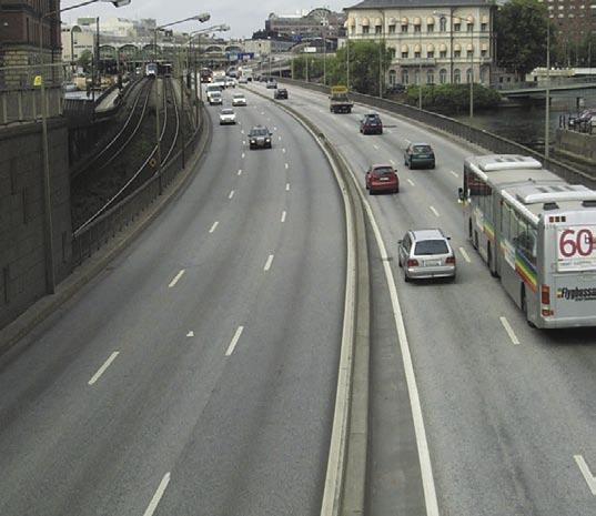
6 6 SUMMARY In the case of the first two alternatives, a description is given of the corridors within which the ultimate alignment of the traffic route could be positioned. The local impact and impact on the traffic system within the entire region is also described. For the Combination Option however, only the regional changes are described. Needless to say, this option will also have a local impact, but the responsibility for the measures and improvements which need to be carried out lies not with the SRA but with municipalities and with the County Council as the body responsible for public transport. All the options have been assessed equally as to their potential for fulfilling the project objectives at the transport system level. The options must all meet present-day environmental and safety requirements, while also considering the conceivable requirements of tomorrow. The trend is that environmental issues are being given increasingly greater consideration, while time is becoming more and more precious. Fast and safe underground road systems in combination with environmentallyfriendly vehicles should make it possible to meet future requirements. Hence, a high standard is the ambition for the road construction options. The new road link is designed at motorway standard with three lanes in each direction of travel. The tunnels are housed in two separate tubes with a design speed of 90 km per hour. Basic data Stockholm Bypass Ulvsunda Diagonal Combination Option Road length, from Kungens Kurva to Häggvik 20.7 km 22.6 km 28.4 km Length of tunnels 16.0 km 13.6 km 20.0 km* Length of slip roads 11.3 km 15.0 km Number of lanes 6 6 Construction cost, at 2003 prices SEK billion SEK billion SEK billion People travelling in morning rush hour across the Saltsjö Mälaren divide people people people Total vehicle mileage 38 million vehicle 38 million vehicle 34 million vehicle in the region 2015 kilometres per day kilometres per day kilometres per day Total vehicle mileage 3.8 million vehicle 3.7 million vehicle 3.5 million vehicle in the inner city 2015 kilometres per day kilometres per day kilometres per day * Including the commuter train tunnel from Älvsjö to Häggvik and the Huvudsta tunnel. After referral for public viewing, one of the three options will be recommended by the SRA Once the plan has been referred for public viewing, all viewpoints have been analysed, and the County Administrative Board has issued its statement, the SRA will decide which option to present to the Government for consideration of permissibility. Whether this will be the Stockholm Bypass or the Ulvsunda Diagonal, the SRA estimates that construction would be able to commence in 2008 at the earliest and that it will take about 8 years to complete.


7 7 How do the various options fulfil the project objectives? Fulfi lment of objective Do Nothing Stockholm Ulvsunda Combination Option Bypass Diagonal Option Level of Service Accessibility Yes Yes No Saltsjö Mälaren divide Yes Yes No Central areas Yes Yes Yes Create a bypass Yes Yes No City access roads Yes Yes Yes Regional Structure Common market Yes Yes No Multicentrical Yes Yes No Economic Growth Conditions for development Yes Yes No Road Safety Fewer dead, seriously injured Gender Equality Improvements for women Environment Health Safety /+ Nature, cultural environment, outdoor leisure Climate targets 0 + Effective use of land and water 0 +/ + + Ditto, materials and energy 0 +/ Finances Construction 0 Operations and maintenance 0 Cost benefi t analysis 0 0/+ 0/+ 0/- The best option is marked with shading. The table above summarises how the various options fulfi l the specifi c project objectives (with a yes or no ). How they fulfi l the other objectives is assessed in relation to the Do Nothing Option and rated on a 5 grade scale using the following symbols: --, -, =, + and ++. The greatest change for the worse is indicated by -- and by ++ for the greatest change for the better. 0 means that the situation is unchanged in relation to the Do Nothing Option. Note that the various factors have differing weights and cannot be added together.
8 8 SUMMARY Corridors and road routes A preliminary design plan sets out suitable corridors for construction options. The corridor should be wide enough to enable the best choice of alignment in the final design plan. The corridor should not, however, be unnecessarily wide since the land within it becomes blocked from other use. A corridor can only be used to describe the general effect on the regional transport system, not for what will happen in the vicinity of the road. For this reason a road route is placed in the corridor given in the preliminary design plan. This road route later serves as the basis for an impact assessment and as such becomes an example of a possible solution within the corridor. Any future changes of the road route as the work progresses will not, however, change the basics in the proposed solution. Joint consultation During the progress of the work, there have been two major joint consultations: one in the autumn of 2002 and one in the spring of The first was arranged at the beginning of the work on the preliminary design plan when three possible road corridors from Kungens Kurva in the south to Häggvik in the north were being examined: the Stockholm Bypass, Ålstensleden and Brommagrenen. The purpose was primarily to get help from those living within the corridors and other stakeholders in order to collect all the factors relevant for continuing work on the preliminary design plan. The interest and response was enormous, with over letters, s and postcards sent in to the SRA, as well as two petitions: No to Ålstensleden and Protect Västerleden. By the time the second joint consultation was carried out, Brommagrenen and Ålstensleden had been removed from the investigation while a further option had emerged: the Ulvsunda Diagonal. An improvements option, Do Nothing Plus was also presented. The aim was then to gather viewpoints on the alternative road corridors and their impact on housing, nature and cultural areas, both during the construction period and once the road had been completed. More than 450 written responses were received at the SRA. The joint consultation has influenced the preliminary design plan as follows: A Combination Option with expanded public transport services and road charging has been given a more prominent place in the preliminary design plan. Environmental impact during the construction period has been studied more thoroughly. Construction materials will for the most part be transported through the end tunnel openings to avoid traffic conflicts and disruptions on the local road network. The Ulvsunda Diagonal Option emerged and afterwards given another connection to the E 4/E 20, where it would be less of a disturbance to those living nearby and at the same time have a better engineering design. More detailed studies have been conducted on long tunnel sections. Nothing emerged to indicate that it would be less safe to drive in tunnels than on normal motorways. Two versions of the Lovön Interchange were designed to reflect different assessments of the cultural interest. For the bridge over Lambarfjärden, two alternatives were presented with heights of 26 metres and 18 metres respectively. On this, the preliminary design plan stated a preference for the higher option. A special study was conducted on the effects of road charging. The result, together with a study of the effects of increased public transport, has been incorporated into the considerations. Information in addition to the consultation Throughout the course of the work on the preliminary design plan, meetings have been held on a continual basis with the County Administrative Board and the local authorities concerned. Meetings with those specifically affected have been arranged on various separate occasions. The general public was given information via a mobile bus exhibition in autumn 2003.


9 9 How will the work process continue? The preliminary design plan will be referred for public viewing from June to September The opinions received will be compiled and commented on before the County Administrative Board issues its statement. During the autumn of 2005 the SRA Stockholm Region will propose the option it considers most suited to the purpose. This option will be referred to the Government for consideration of permissibility. The planning process will then enter into a new phase and include the final design plan, construction documents and construction works. It will not be possible to start construction before the year The works are expected to continue for about 8 years. The North-South Communications process
10 Swedish Road Administration Stockholm Region SE Solna, Sweden Street address: Sundbybergsvägen 1 vagverket.sto@vv.se Tel: +46 (0) Telefax: +46 (0) Text telephone: +46 (0)
PREPARED FOR: PLATTEVIEW ROAD CORRIDOR STUDY EXECUTIVE SUMMARY
 PREPARED FOR: PLATTEVIEW ROAD CORRIDOR STUDY EXECUTIVE SUMMARY SEPTEMBER 2016 Introduction The Platteview Road Corridor Study was led by the Metropolitan Area Planning Agency (MAPA) with assistance from
STOCKHOLM ROYAL SEAPORT
 STOCKHOLM ROYAL SEAPORT a world-class environmental urban district Sweden is an innovative nation and home to some of the largest global brands in the world. Sweden has succeeded in combining economic
2 nd European Forum of Road Tunnel Safety Officers
 2 nd European Forum of Road Tunnel Safety Officers Brussels, 18 January 2012 How to define a continuous process to improve safety? Bernt Freiholtz How to define a continuous process to improve safety?
The Village of Sugar Grove, in partnership with Kane County, the Illinois Department of Transportation, and the Illinois Tollway welcomes you to the
 The Village of Sugar Grove, in partnership with Kane County, the Illinois Department of Transportation, and the Illinois Tollway welcomes you to the first Public Meeting for the proposed interchange improvement
ICOMOS Technical Review. Phase II of HIA of Stockholm Bypass and Ekëro Road projects
 ICOMOS Technical Review Property Royal Domain of Drottningholm State Party Sweden Property ID 559 Date inscription 1991 Criteria (iv) Project Phase II of HIA of Stockholm Bypass and Ekëro Road projects
SUMMARY. An Attractive, Competitive and Sustainable GREATER MONTREAL. Draft Metropolitan Land Use and Development Plan. April 2011
 April 2011 Draft Metropolitan Land Use and Development Plan GREATER MONTREAL An Attractive, Competitive and Sustainable SUMMARY Message from the Chair I am pleased to introduce this draft of the Metropolitan
TOWN OF WHITBY REPORT RECOMMENDATION REPORT
 TOWN OF WHITBY REPORT RECOMMENDATION REPORT REPORT TO: Council REPORT NO: PL 95-09 DATE OF MEETING: October 13, 2009 PREPARED BY: Planning/Public Works Joint Report FILE NO(S): N/A LOCATION: N/A REPORT
The Illinois Department of Transportation and Lake County Division of Transportation. Route 173, including the Millburn Bypass
 The Illinois Department of Transportation and Lake County Division of Transportation welcome you to this Public Hearing for U.S. Route 45 from Illinois Route 132 to Illinois Route 173, including the Millburn
Eglinton West LRT Update
 Eglinton West LRT Update Community Consultation Update May 16, 2016 Background Rapid transit along Eglinton Ave between Kennedy Station and Pearson Airport was included in the Metrolinx Regional Transportation
Q1 Report 2014/ September Klas Balkow CEO
 Report 2014/15 10 September 2014 Klas Balkow CEO Agenda 2014/15 Events after period-end Strategic priorities Q&A Store opening in Levanger, Norway, in June 2014 2 High energy and strong position 186 stores
Public Information Centre #1
 and Highway 401 Interchange Improvements WELCOME Public Information Centre #1 Veterans Memorial Parkway Extension and Highway 401 Interchange Improvements Study May 23, 2012 4 p.m. to 7 p.m. Brief Overview
Walkable cities, public space networks and river systems
 Walkable cities, public space networks and river systems Brussels, 01.12.2016 Yellow design Foundation 39, Rue de l Association - 1000 Bruxelles www.ydesignfoundation.org Tel : +32(0)2 734 02 48 Email
RESOLUTION NO. R Refining the route, profile and stations for the Downtown Redmond Link Extension
 RESOLUTION NO. R2018-32 Refining the route, profile and stations for the Downtown Redmond Link Extension MEETING: DATE: TYPE OF ACTION: STAFF CONTACT: Capital Committee Board PROPOSED ACTION 09/13/2018
9 CITY OF VAUGHAN OFFICIAL PLAN AMENDMENT NO BOCA EAST INVESTMENTS LIMITED
 9 CITY OF VAUGHAN OFFICIAL PLAN AMENDMENT NO. 631 - BOCA EAST INVESTMENTS LIMITED The Planning and Economic Development Committee recommends the adoption of the recommendations contained in the following
Welcome. Walk Around. Talk to Us. Write Down Your Comments
 Welcome This is an information meeting introducing the applications for proposed redevelopment of the Yorkdale Shopping Centre site at 3401 Dufferin Street and 1 Yorkdale Road over the next 20+ years,
Dresden s SUMP with broad citizen participation in the Dresden Debate
 Dresden s SUMP with broad citizen participation in the Dresden Debate 2014 Annual Polis Conference 27 28 November 2014, Madrid Kerstin Burggraf, Urban planning office Topics Something about Dresden Dresden
ROAD CLOSURE AND LAND USE AMENDMENT SILVER SPRINGS (WARD 1) NORTHEAST OF NOSEHILL DRIVE NW AND SILVER SPRINGS ROAD NW BYLAWS 2C2018 AND 29D2018
 NORTHEAST OF NOSEHILL DRIVE NW AND SILVER SPRINGS ROAD NW BYLAWS 2C2018 AND 29D2018") Page 1 of 19 EXECUTIVE SUMMARY This application proposes redesignating two parcels in the community of Silver Springs from Special Purpose Future Urban Development (S-FUD) District and undesignated road
Page 1 of 19 EXECUTIVE SUMMARY This application proposes redesignating two parcels in the community of Silver Springs from Special Purpose Future Urban Development (S-FUD) District and undesignated road
4. Good Practice Example: The SYMBIO-CITY Approach (Sweden)
") 4. Good Practice Example: The SYMBIO-CITY Approach (Sweden) Key words Sustainable urban development, urban planning, education, planning methodology Name and location for good practice example and responsible
4. Good Practice Example: The SYMBIO-CITY Approach (Sweden) Key words Sustainable urban development, urban planning, education, planning methodology Name and location for good practice example and responsible
Introduction. Who we are. Purpose of this public consultation
 Introduction Who we are Purpose of this public consultation SHE Transmission are proposing to submit a planning application for our proposed Development of a High Voltage Direct Current Switching Station
Caithness HVDC Switching Station Pre Application Consultation Event. August 2016
 Caithness HVDC Switching Station Pre Application Consultation Event August 2016 Introduction Who we are Purpose of this public consultation Other SSE Businesses SHE Transmission are proposing to submit
Exeriencies from the Livable City and. Integrated Transport and. Carl-Johan Engström, prof KTH. Urban Planning. other projects
 Integrated Transport and Urban Planning Exeriencies from the Livable City and other projects Carl-Johan Engström, prof KTH An ultimate challenge to find urban transport systems that face the dual needs
Land Use Amendment in Southwood (Ward 11) at and Elbow Drive SW, LOC
 at and Elbow Drive SW, LOC") 2018 November 15 Page 1 of 10 EXECUTIVE SUMMARY This land use amendment application was submitted by Rick Balbi Architect on 2017 August 31 on behalf of Sable Developments Ltd, and with authorization from
2018 November 15 Page 1 of 10 EXECUTIVE SUMMARY This land use amendment application was submitted by Rick Balbi Architect on 2017 August 31 on behalf of Sable Developments Ltd, and with authorization from
Shift Rapid Transit Public Participation Meeting May 3, 2017
 Shift Rapid Transit Public Participation Meeting May 3, 2017 Shift Rapid Transit Initiative Largest infrastructure project in the city s history. Rapid Transit initiative will transform London s public
EARLY PICTURE OF THE WHOLE. Including landscape in long-term spatial planning
 EARLY PICTURE OF THE WHOLE Including landscape in long-term spatial planning 1 2 A MULTI-DIMENSIONAL TOOL The landscape is a single entity. Every person who traverses the landscape can experience this.
Heritage Impact Assessment
 Heritage Impact Assessment The potential impact of the Stockholm Bypass and Ekerö Road project on the Outstanding Universal Value of the World Heritage Property of Royal Domain of Drottningholm Sweden
Guiding Principles for the SR 520 Replacement Project
 Guiding Principles for the SR 520 Replacement Project Presentation to the Board of Regents Theresa Doherty Assistant Vice President for Regional Affairs May 18, 2006 F-14 The University of Washington is
Ryoko Iizuka Finance, Economics and Urban Department
 THE WORLD BANK www.worldbank.org/eco2 Eco 2 Cities Guide Ryoko Iizuka Finance, Economics and Urban Department 09.12.2011 1 Challenge: How? The 350 page Eco 2 Book elaborates on the principles, methods
POLICY AMENDMENT AND LAND USE AMENDMENT KILLARNEY/GLENGARRY (WARD 8) NW CORNER OF RICHMOND ROAD AND 33 STREET SW BYLAWS 1P2015 AND 7D2015
 NW CORNER OF RICHMOND ROAD AND 33 STREET SW BYLAWS 1P2015 AND 7D2015") Page 1 of 13 EXECUTIVE SUMMARY This application seeks to redesignate an RC-2 (Residential Contextual One/Two Dwelling) parcel to MC-Gd72 (Multi-Residential Contextual Grade-Oriented) to allow for multi-residential
Page 1 of 13 EXECUTIVE SUMMARY This application seeks to redesignate an RC-2 (Residential Contextual One/Two Dwelling) parcel to MC-Gd72 (Multi-Residential Contextual Grade-Oriented) to allow for multi-residential
CITY OF CHARLOTTESVILLE, VIRGINIA CITY COUNCIL AGENDA
 CITY OF CHARLOTTESVILLE, VIRGINIA CITY COUNCIL AGENDA Agenda Date: December 16, 2013 Action Required: Adoption of Resolution Presenter: Staff Contacts: Title: James E. Tolbert, AICP, Director of NDS James
Urban Planning and Land Use
 Urban Planning and Land Use 701 North 7 th Street, Room 423 Phone: (913) 573-5750 Kansas City, Kansas 66101 Fax: (913) 573-5796 Email: planninginfo@wycokck.org www.wycokck.org/planning To: From: City Planning
Urban Development and Planning in Vienna
 Urban Development and Planning in Vienna Angelika Winkler Municipal Department for Urban Development and Planning Urban Development and Planning in Vienna April 2013 1 Vienna Key Facts and Figures federal
The Dresden Sustainable Urban Mobility Plan (SUMP)
") The Dresden Sustainable Urban Mobility Plan (SUMP) photo: Frank Fiedler UN-Habitat III Regional Meeting Side-event Sustain and clean mobility for the New Urban Agenda Prague, 16.03.2016 Dipl.-Ing. Frank
The Dresden Sustainable Urban Mobility Plan (SUMP) photo: Frank Fiedler UN-Habitat III Regional Meeting Side-event Sustain and clean mobility for the New Urban Agenda Prague, 16.03.2016 Dipl.-Ing. Frank
SWEDISH EDUCATION AND TRAINING ON CONCRETE BLOCK PAVEMENTS
 SWEDISH EDUCATION AND TRAINING ON CONCRETE BLOCK PAVEMENTS SILFWERBRAND, Johan, Professor. Swedish Cement and Concrete Research Institute (CBI) SE-100 44 Stockholm, SWEDEN Tel.: +46-8-6961100, Fax.: +46-8-243137,
IOWA HIGHWAY 57 / WEST 1 ST STREET STUDY PUBLIC INFORMATIONAL MEETING APRIL 22, 2014
 IOWA HIGHWAY 57 / WEST 1 ST STREET STUDY PUBLIC INFORMATIONAL MEETING APRIL 22, 2014 INTRODUCTION The City of Cedar Falls and the Iowa Department of Transportation are conducting a Public Informational
TEHRAN LONG TERM URBAN RAIL PLAN
 TEHRAN LONG TERM URBAN RAIL PLAN Introduction and Methodology Introduction Greater Tehran is currently one of the most populated mega cities in the world with an estimated population of 14 million inhabitants
2002/ Modernisation Road N 4
 2002/000-606.02 - Modernisation Road N 4 1. Basic Information 1.1. CRIS Number 2002/000-606.02 1.2. Title: Modernisation of the national road No 4 1.3 Sector : Cross Border Co-operation / Infrastructure
I-84 Hartford Project Open Planning Studio #12. April 25, 2017
 I-84 Hartford Project Open Planning Studio #12 April 25, 2017 Meeting Agenda 1. I-84 Hartford Project alternatives update 2. Multimodal station area planning 3. I-84 / I-91 Interchange Study coordination
Newcourt Masterplan. November Exeter Local Development Framework
 Newcourt Masterplan November 2010 Exeter Local Development Framework Background The Exeter Core Strategy Proposed Submission sets out the vision, objectives and strategy for the development of Exeter up
Scotswood to North Brunton improvement scheme
 A1 Scotswood to North Brunton improvement scheme Introduction Highways England is a Government run company. We are responsible for the operation, maintenance and improvements to England s motorways and
SBCAG STAFF REPORT. MEETING DATE: March 17, 2016 AGENDA ITEM: 5I
 SBCAG STAFF REPORT SUBJECT: Cabrillo-UPRR Bridge Project MEETING DATE: March 17, 2016 AGENDA ITEM: 5I STAFF CONTACT: Fred Luna RECOMMENDATION: Authorize the chair to sign a Memorandum of Understanding
City of Cornwall Municipal Class Environmental Assessment. Proposed Improvement and Extension of Lemay Street
 Welcome City of Cornwall Municipal Class Environmental Assessment Proposed Improvement and Extension of Lemay Street Redevelopment and Design of the Municipal Works Yard Public Information Centre #1 Thursday,
ARGENTA TRAIL (CSAH 28/63) REALIGNMENT SOUTH PROJECT (CP 63-25)
 REALIGNMENT SOUTH PROJECT (CP 63-25)") ARGENTA TRAIL (CSAH 28/63) REALIGNMENT SOUTH PROJECT (CP 63-25) Preliminary Design Report February 2015 Prepared For: City of Inver Grove Heights Dakota County Prepared By: Kimley-Horn and Associates,
ARGENTA TRAIL (CSAH 28/63) REALIGNMENT SOUTH PROJECT (CP 63-25) Preliminary Design Report February 2015 Prepared For: City of Inver Grove Heights Dakota County Prepared By: Kimley-Horn and Associates,
Networking for Urban Vitality Amsterdam, 23 June 2016
 Networking for Urban Vitality Amsterdam, 23 June 2016 NUVit: European network for infrastructure and urban vitality On 23 June 2016, the conference Networking for Urban Vitality (NUVit) was held at Amsterdam
THE STILLWATER BRIDGE STORY
 THE STILLWATER BRIDGE STORY 1931 Stillwater Bridge Part I: The Backstory Behind the Bridge Undoubtedly the highest profile road project in Minnesota is the new bridge at Stillwater, the St. Croix Crossing.
Evaluation Criteria. Detailed Evaluation Criteria
 Evaluation Criteria Detailed Evaluation Criteria Community Well-being A safe and socially inclusive service that improves access to key community destinations and provides transportation choices for Calgarians.
TOWN AND COUNTRY PLANNING ACT 1990 (AS AMENDED).
.") FAO: D. Williams Isle of Anglesey County Council Council Offices Llangefni Anglesey LL77 7TW 16 November 2017 DCRM Ref. No: WN0904-QUD-OS-LET-00002_English Dear Mr Williams TOWN AND COUNTRY PLANNING ACT
FAO: D. Williams Isle of Anglesey County Council Council Offices Llangefni Anglesey LL77 7TW 16 November 2017 DCRM Ref. No: WN0904-QUD-OS-LET-00002_English Dear Mr Williams TOWN AND COUNTRY PLANNING ACT
Policy for management and protection of the coast
 Policy for management and protection of the coast Policy for management and protection of the coast Mona Ohlsson Samhällsbyggnadsförvaltningen Ystads kommun, 2008 3 THE MUNICIPALITY GUIDELINES REGARDING
1.0 Purpose of a Secondary Plan for the Masonville Transit Village
 Report to Planning and Environment Committee To: Chair and Members Planning & Environment Committee From: John M. Fleming Managing Director, Planning and City Planner Subject: Masonville Transit Village
Q4 Report 2013/ June Klas Balkow CEO
 Q4 Report 2013/14 11 June 2014 Klas Balkow CEO Agenda Q4 2013/14 Full year 2013/14 Strategic priorities Events after period-end Q&A 2 High energy and strong position 185 stores in 5 countries omni-channel
Strasbourg SUMP Award: Finalist factsheet. Local Transport facts. Urban transport policy objectives of the city:
 Strasbourg 2013 SUMP Award: Finalist factsheet Local Transport facts Name of the authority: Urban Community of Strasbourg, FR Website: www.strasbourg.eu Contact: Maeva Moreau Telephone: +33 388436514 Email:
COUNCIL ATTACHMENT 2 HIGHWAY 7 CORRIDOR AND VAUGHAN NORTH-SOUTH LINK
 COUNCIL ATTACHMENT 2 HIGHWAY 7 CORRIDOR AND VAUGHAN NORTH-SOUTH LINK Welcome! The purpose today is to: Present the Study Background; Describe Alignment Alternatives Analyzed; Present the Evaluation of
6 Growth Management Challenges and Opportunities
 6 Growth Management Challenges and Opportunities The Town has established a goal of attaining a 50% participation rate with respect to employment opportunities versus residential population. The Town s
The Development of the Underground Infrastructure of the System of Mobility in Torino
 The Development of the Underground Infrastructure of the System of Mobility in Torino Biagio Burdizzo 1 Bruna Cavaglia 2 Lorenzo Peretti 3 1 Director, Municipality of Torino - Infrastructure and Mobility
Figure 5. Previously Identified Viable Corridors
 OVERVIEW The Central Florida Expressway Authority (CFX) is evaluating the potential to expand SR 408 from its current eastern terminus along SR 50 to SR 520 in northeastern Orange County, Fl. This new
Welcome. Northern Segment of Hwy 100 I-90 to South of Madison Street Meeting Goals:
 Welcome Northern Segment of Hwy 100 I-90 to South of Madison Street Meeting Goals: - Review Environmental Assessment - Share Preferred Alternative -Receive Public Comments 2003 EA Preferred Alternative
Commissioners Road West Realignment Environmental Assessment
 City of London Commissioners Road West Realignment Environmental Assessment Public Information Centre No. 1 March 30, 2017 Welcome to the Public Information Centre This first Public Information Centre
Welcome. Green Line LRT. Beltline Alignment Options. Stay engaged! Follow the Green Line story at calgary.ca/greenline
 Welcome Green Line LRT Beltline Alignment Options Stay engaged! Follow the Green Line story at calgary.ca/greenline Green Line LRT Why are we here? Our Challenge Determine the best alignment in the Beltline.
NEWSLETTER #03 BEAUDESERT ROAD LOGAN MOTORWAY
 NEWSLETTER #03 MT. LINDESAY HIGHWAY Feedback shapes design changes Thank you to the more than 600 stakeholders and community members that provided feedback on the Logan Enhancement Project initial concept
6:00 8:00 PM I-95 FROM EXIT 57 TO EXIT 60 PROJECT
 PUBLIC INFORMATIONAL MEETING TUESDAY, APRIL 27, 2010 AT NEWBURYPORT CITY HALL, AUDITORIUM 60 PLEASANT STREET NEWBURYPORT, MASSACHUSETTS 6:00 8:00 PM FOR THE PROPOSED WHITTIER BRIDGE / I-95 IMPROVEMENTS
SCARBOROUGH SUBWAY EXTENSION. Scarborough Subway Extension. Final Terms of Reference
 Scarborough Subway Extension Final Terms of Reference 1 1.0 Introduction and Background 1.1 Introduction Toronto City Council recently confirmed support for an extension of the Bloor-Danforth Subway from
PEOPLE S COMMITTEE OF HO CHI MINH CITY DEVELOPMENT STRATEGY FOR HO CHI MINH CITY S INFRASTRUCTURE
 PEOPLE S COMMITTEE OF HO CHI MINH CITY DEVELOPMENT STRATEGY FOR HO CHI MINH CITY S INFRASTRUCTURE Singapore, July 2012 1 GENERAL INFORMATION 2 GENERAL INFORMATION The centre for economics, culture, science
1. Introduction to Linköping
 INTERREG IVC - Project "Hybrid Parks" Partner 5: Linköping Municipality Environment and Community Development Department Situation Report, April 2012 1. Introduction to Linköping Linköping is Sweden s
SDOT DPD. SDOT Director s Rule DPD Director s Rule DCLU DR SED DR of 7 CITY OF SEATTLE
 SDOT SDOT Director s Rule 2-07 DPD Applicant: CITY OF SEATTLE Page 1 of 7 Supersedes: DCLU DR 11-93 SED DR 93-4 Seattle Department of Transportation (SDOT) Department of Planning and Development (DPD)
Lake Macquarie City. A copy of the published amendment including the instrument and maps, is provided in Attachment 7 of this report.
 Planning Proposal Amendment No. 77 to Lake Macquarie Local Environmental Plan 2004 and proposed Amendment to Draft Lake Macquarie Local Environmental Plan 2013 Minor Zone Boundary Adjustment - Pasminco
Eastern Terminus TECHNICAL MEMORANDUM CENTRAL BROWARD EAST-WEST TRANSIT ANALYSIS BROWARD COUNTY, FLORIDA
 Eastern Terminus TECHNICAL MEMORANDUM CENTRAL BROWARD EAST-WEST TRANSIT ANALYSIS BROWARD COUNTY, FLORIDA FINANCIAL PROJECT ID NUMBER 411189-2-22-01 FLORIDA DEPARTMENT OF TRANSPORTATION DISTRICT 4 Prepared
Bonaventure Project Full Submission. TAC 2018 Sustainable Urban Transportation Award
 Bonaventure Project Full Submission TAC 2018 Sustainable Urban Transportation Award 1) Developing and Improving Sustainable Urban Transportation The Bonaventure Project is a series of strategic undertakings
SCARBOROUGH RAPID TRANSIT ENVIRONMENTAL PROJECT REPORT CHAPTER 2 PROJECT DESCRIPTION. Table 2-4: North Segment Alignment Analysis 2-21
 Table 2-4: North Segment Alignment Analysis 2-21 SCARBOROUGH RAPID TRANSIT Based on the above analysis (detailed analysis is contained in Appendix A-4), North Alignment 3 is preferred because it: Has the
Thank you for coming. We want to hear your views on proposed improvements to the A1 between junction 65 (Birtley) and junction 67 (Coal House).
 and junction 67 (Coal House).") Welcome Thank you for coming. We want to hear your views on proposed improvements to the between junction 65 (Birtley) and junction 67 (Coal House). This is your opportunity to provide comments on our
Welcome Thank you for coming. We want to hear your views on proposed improvements to the between junction 65 (Birtley) and junction 67 (Coal House). This is your opportunity to provide comments on our
RIGA LATVIA. KEY FEATURES OF THE CITY Demographic Facts. Urban Figures. Heritage. EXISTING GOVERNANCE MECHANISMS Development and Management Plans
 RIGA LATVIA KEY FEATURES OF THE CITY Demographic Facts around 700.000 inhabitants in the city 1.15 million people in the Riga region Urban Figures the medieval core of the Old Town the 19th century grid
Route Planning and Environmental Assessment Study Highway 17 Four-Laning from Sudbury to Markstay GWP
 Route Planning and Environmental Assessment Study Highway 17 Four-Laning from Sudbury to Markstay GWP 5031-09-00 Presentation to City of Greater Sudbury Council: January 26, 2011 1 Roch Pilon, P.Eng. Head,
Loop Detectors for Motorways
 Loop Detectors for Motorways DN-ITS-03020 October 2013 DN Design Standards TRANSPORT INFRASTRUCTURE IRELAND (TII) PUBLICATIONS About TII Transport Infrastructure Ireland (TII) is responsible for managing
Scope of Services. River Oaks Boulevard (SH 183) Corridor Master Plan
 Corridor Master Plan") Scope of Services River Oaks Boulevard (SH 183) Corridor Master Plan PROJECT AREA The project area consists of the River Oaks Boulevard (SH 183) corridor bounded by SH 199 at the northern end and the Trinity
Scope of Services River Oaks Boulevard (SH 183) Corridor Master Plan PROJECT AREA The project area consists of the River Oaks Boulevard (SH 183) corridor bounded by SH 199 at the northern end and the Trinity
(blank page) WestConnex New M Roads and Maritime Services Environmental impact statement
 WestConnex New M Roads and Maritime Services Environmental impact statement") (blank page) WestConnex New M5 5-42 (blank page) WestConnex New M5 5-44 5.5 Tunnels 5.5.1 Main alignment tunnels The main alignment tunnels would be about nine kilometres long, with the western tunnel
(blank page) WestConnex New M5 5-42 (blank page) WestConnex New M5 5-44 5.5 Tunnels 5.5.1 Main alignment tunnels The main alignment tunnels would be about nine kilometres long, with the western tunnel
TOMORROW S SOLUTIONS TODAY
 TOMORROW S SOLUTIONS TODAY Tyréns is one of Sweden s leading community development consultancies. Together with our customers and partners, we create sustainable solutions in the fields of urban development
Lars Nyberg The Stockholm Parks Network & Sustainability Presentation at Porto Conference 10 November 2009
 2009-11-02 Lars Nyberg The Stockholm Parks Network & Sustainability Presentation at Porto Conference 10 November 2009 During recent years sustainability has been spelled out as a focus for spatial planning.
Green Line North Centre City Alignment
 Project overview The Green Line will be an important piece of Calgary's transit network, adding 40 kilometres of track to the existing 59 kilometre LRT system. End-to-end, the line will connect North Pointe
GOOD TOMORROW! SOLUTIONS FOR THE FUTURE
 GOOD TOMORROW! SOLUTIONS FOR THE FUTURE What we do today impacts our future. At Tyréns we work with building communities, with the goal of creating better conditions for the cities of today and tomorrow.
INTERNATIONAL STANDARD
 INTERNATIONAL STANDARD IEC 60364-4-41 Fifth edition 2005-12 GROUP SAFETY PUBLICATION Low-voltage electrical installations Part 4-41: Protection for safety Protection against electric shock This English-language
COMPONENT 4 Feasibility studies. Prague Suchdol
 COMPONENT 4 Feasibility studies Prague Suchdol Almada, March 12th - 13th 2012 SUMMARY Municipality Praha-Suchdol is a recipient of a public transportation services only Insufficient connection with city
1.0 INTRODUCTION & BACKGROUND
 1.0 INTRODUCTION & BACKGROUND 1.1 GENERAL The Consulting Team was retained by the City of Edmonton in 2010 to complete a for the replacement of the Walterdale Bridge and the approach roads, as required,
Atlanta BeltLine Corridor Environmental Study. Scoping Meeting August 2008
 Atlanta BeltLine Corridor Environmental Study Scoping Meeting August 2008 What Will We Be Discussing Today? Study Overview - How Did We Get Here? - What Is the Study About? - Who Is Involved? - Where Is
STAFF REPORT INFORMATION ONLY. Vacuum Waste Collection Systems SUMMARY. Date: March 19, Executive Committee. To: Deputy City Manager.
 Vacuum Waste Collection Systems STAFF REPORT INFORMATION ONLY Date: March 19, 2008 To: From: Wards: Reference Number: Executive Committee Deputy City Manager All Wards P:\2008\Cluster B\PLN\ec080020 SUMMARY
Outer Congress Street Land Use
 Outer Congress Street Land Use Outer Congress Street, with its historic residential district, natural resource and open space amenities, trail network, and proximity to major transportation infrastructure
WELCOME. This consultation at this early stage is an opportunity to share your comments and suggestions with us.
 WELCOME Welcome to our public consultation event. We are looking forward to receiving your views and suggestions for the proposed leisure centre in Spelthorne. This consultation at this early stage is
Inform you of the purpose and scope of the study for PTH 100 and a proposed future St. Norbert Bypass;
 WELCOME The intent of today s Open House is to: Inform you of the purpose and scope of the study for PTH 100 and a proposed future St. Norbert Bypass; Review highway crossing locations, future access closures
WHAT IS THE PURPOSE OF THE OPEN HOUSE?
 WHAT IS THE PURPOSE OF THE OPEN HOUSE? OPEN HOUSE PURPOSE The purpose of the open house is to provide an update on the study process and introduce the preliminary concept alternatives. The open house provides
GLEN ROAD PEDESTRIAN BRIDGE ENVIRONMENTAL ASSESSMENT STUDY PUBLIC INFORMATION CENTRE #2 OCTOBER 24, 2017
 GLEN ROAD PEDESTRIAN BRIDGE ENVIRONMENTAL ASSESSMENT STUDY PUBLIC INFORMATION CENTRE #2 OCTOBER 24, 2017 Glen Road Pedestrian Bridge Class Environmental Assessment 1 WELCOME! Welcome to the second Public
Edmonton s LRT Setting the Stage for Heading Further South
 4 Capital Projects Project Updates Edmonton s LRT Setting the Stage for Heading Further South Art Washuta, P.Eng. AECOM Canada Ltd. Edmonton, Alberta Carole Cej, P.Eng. City of Edmonton Edmonton, Alberta
Relief Line Project Assessment
 Relief Line Project Assessment Public Information Centre April 5, 2017 Tonight s Meeting PURPOSE To review the preferred alignment for the Local Segment. AGENDA 6:30 Open House 7:00 Presentation / Discussion
Transportation Committee
 Transportation Committee Business Item No. 2013-286SW Meeting date: October 14, 2013 For the Metropolitan Council meeting of October 16, 2013 Subject: Southwest Light Rail Transit (Green Line Extension):
master plan of highways
 scope of work master plan of highways abstract This Scope of Work outlines the tasks and goals of updating the Master Plan of Highways, as well as the outreach that will be used in the planning process.
EXECUTIVE SUMMARY. Introduction
 EXECUTIVE SUMMARY Introduction State Route 68 is a designated scenic route that connects the world-renowned Monterey Peninsula to US Highway 101 and the Salinas Valley. SR 68 is a key route for bicycle,
Agenda Standing Policy Committee on Infrastructure Renewal and Public Works January 31, 2013 REPORTS
 Agenda Standing Policy Committee on Infrastructure Renewal and Public Works January 31, 2013 REPORTS Item No. 1 Amendment of the Transportation Master Plan to Reflect the Recommendation of the Southwest
To ensure that city planning achieves its desired impact, the City Plan identifies four focus areas in the outer city. Skärholmen, which has an
 Stockholm City Plan To ensure that city planning achieves its desired impact, the City Plan identifies four focus areas in the outer city. Skärholmen, which has an important regional function, is one focus
INTERNATIONAL STANDARD
 INTERNATIONAL STANDARD IEC 61508-2 First edition 2000-05 BASIC SAFETY PUBLICATION Functional safety of electrical/electronic/ programmable electronic safety-related systems Part 2: Requirements for electrical/electronic/
112th Avenue Light Rail Options Concept Design Report JUNE 2010 PREPARED FOR PREPARED BY TBG PGH
 112th Avenue Light Rail Options Concept Design Report JUNE 2010 PREPARED FOR PREPARED BY TBG060310124909PGH C ontents Introduction 1 Project Overview 1 Public Involvement and Technical Coordination 4 Description
TOD 203 CORRIDOR PLANNING and TOD
 2 CORRIDOR PLANNING and Scales of What You Will Learn The Transit Corridor Types of Corridors Objectives and Strategies for Transit and at the Corridor Level Main Street Corridor Planning and Your Trainers
SH 199 Corridor Master Plan. Community Meeting No. 2 May 31, 2017
 Community Meeting No. 2 May 31, 2017 Transportation Projects On or Near SH 199 SH 199 from 0.3 miles south of FM 1886 to south end of Lake Worth bridge Construct freeway mainlanes and frontage roads 10-Year
CITY OF VAUGHAN EXTRACT FROM COUNCIL MEETING MINUTES OF JUNE 7, 2016
 Item 5, Report No. 26, of the Committee of the Whole (Working Session), which was adopted without amendment by the Council of the City of Vaughan on June 7, 2016. 5 MUNICIPAL CLASS ENVIRONMENTAL ASSESSMENT
Services Department B September 10, 2007
 Report To: Development Services Committee Item: Date of Report: DS-07-246 September 5, 2007 From: Commissioner, Development File: Date of Meeting: Services Department B7200-0001 September 10, 2007 Subject: