November 2, 2015 at 5:15pm City Council Chambers, 3rd Floor, City Hall, 1737 Main Street Columbia, South Carolina 29201
|
|
|
- Julia Washington
- 5 years ago
- Views:
Transcription
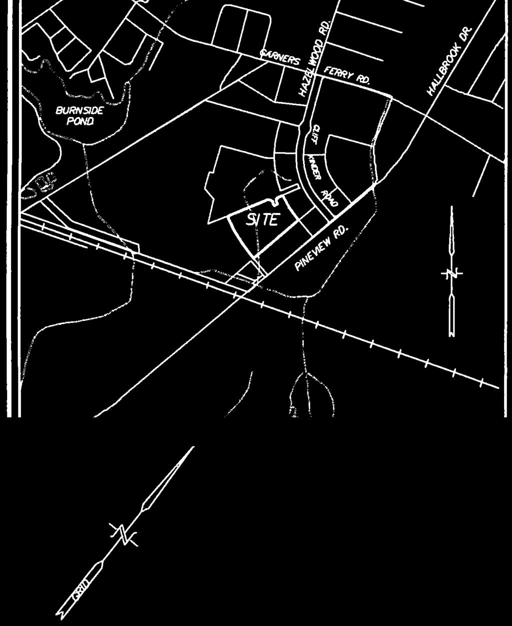
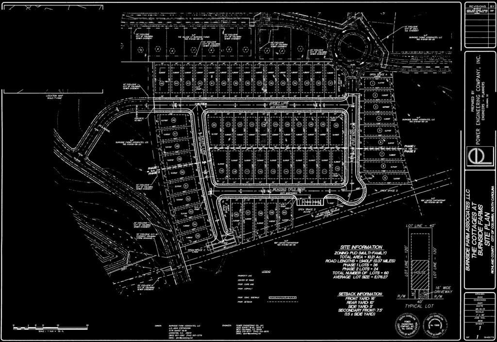
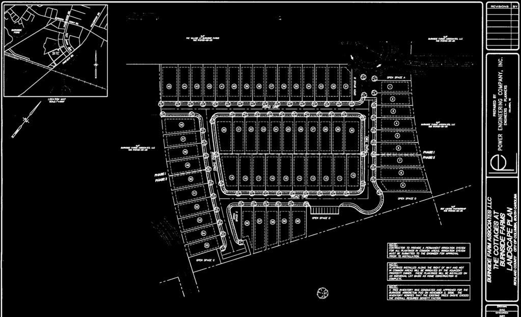
1 Subject Property: PLANNING COMMISSION SITE/SUBDIVISION PLAN CASE SUMMARY ACRES, WESTSIDE OF CLIF KINDER BOULEVARD COTTAGES AT BURNSIDE FARM BURNSIDE FARMS ASSOCIATES, LLC November 2, 2015 at 5:15pm City Council Chambers, 3rd Floor, City Hall, 1737 Main Street Columbia, South Carolina acres, Westside of Clif Kinder Boulevard, TMS# Council District: 4 Proposal: Request site plan review of an 60 lot single-family residential housing development Applicant: Proposed Use: Staff Recommendation: John Stephenson, Burnside Farm Associates, LLC Single-family Residences Approval with staff comments. Detail: The proposed residential subdivision, located within the Burnside Farms Planned Unit Development, will contain 60 single-family residences on acres. Each lot will contain approximately 5,000 sq. ft., two off-street parking spaces and a single-family residence approximately 1,800 sq. ft. The development also contains additional off-street parking spaces for guests within common area. In addition, Pursuant to SC Code (a), a local planning commission shall, by proper certificate, approve and authorize the name of a street or road laid out within the territory over which the commission has jurisdiction. The proposed street names (Salers Lane, Jersey Lane, Beacons Field Bend) have received approval from Richland County E-911 Addressing. Should the Commission be inclined to grant approval of the site plan, staff would request that the Commission grant approval subject staff comments. CITY AGENCY COMMENTS FOR SITE/SUBDIVISION PLAN REVIEW John Fellows, Planning Recommend approval with conditions: 1. Sidewalk Crossings: a handicap ramp should be positioned to allow for crossing in each direction. i.e. three-way intersection would have 4 ramps, a four way intersection would have 4 ramps a T or curve would not have any ramps. 2. Plans do not indicate dimension of sidewalk. Min. width of the sidewalk is to be 5 feet. 3. Plans do not indicate the dimension of the border area between the curb and sidewalk. The minimum width is to be 4 feet. 4. Due to the small lots and traditional neighborhood development style of this development all phone, electrical, and other above ground utility boxes, towers, etc. shall be located in areas that will not be in front yards of lots. Locations could be side yards, open space lots, rear yards, or side yards. A plan for such cabinets should be submitted with any PAGE 1 OF 2
2 K. Brian Cook, Zoning Administrator Johnathan Chambers, Land Development Administrator Robert Harkins, Plans Examiner Scott Rogers, Utilities David Brewer, Traffic Engineering David Koon, Fire Department Scott Holder, Land Development Planner Sara Hollar, Forestry Michael Jaspers, Stormwater Robert Sweatt, Street John Hooks, Solid Waste John Spade, Parking easement documents to the city prior to construction. Recommend approval with condition: 1. Must meet all requirements of the PUD. Recommend approval with conditions: 1. Planning Commission approval includes the naming of Jersey Lane, Salers Lane and Beacons Field Bend all of which have been approved by Richland County E911. Recommend approval. Recommend approval with conditions: 1. Any needed upgrade, extension or relocation of City utilities must be provided by the developer. 2. Any privately owned/maintained utilities or permanent structures cannot be located inside City of Columbia utility easements. 3. Water mains, sewer mains, water meters that are 4 or larger or any privately maintained utilities will not be allowed inside public right-ofways or under sidewalks without an approved encroachment permit and written approval from the City Engineer. Coordination between the Civil Engineer, Architect and Mechanical Engineer to allow room for these utilities on the developed property is strongly encouraged. 4. If sewer flows for this project result in flows of 4,000 gallons per day or above calculations must be submitted to the City's Engineering department to determine how the proposed project will affect the City s sewer system. Depending upon the effects of the projected flows this project may or may not be approved. If required, these calculations should be submitted to the Engineering department as soon as possible. 5. Lot 45 may be unbuildable based upon location of sewer easement. Recommend approval with conditions: 1. Due to roadway width, recommend on-street parking be prohibited on one side of street. 2. Power grid will require any street lighting to be fed underground. If decorative lighting is desired, it must be installed to City specs (available from Traffic Engineering) and deeded to the City for maintenance. 3. Separate metered power circuits are required for City-maintained decorative street lighting. No SCE&G-leased decorative lighting will be accepted by the City. Recommend approval. Recommend approval with condition: 1. Trees should not be placed in sight line triangles at road intersections. It is recommended that trees be planted near parking spaces adjacent to "Open Space D" that meet requirement for all parking spaces to be within 40' of the trunk of a shade tree. Recommend approval with condition: 1. Once species is approved by Forestry and Beautification and trees planted, provide two year warranty to replace any trees that do not survive. Recommend approval with conditions: 1. Construction within the storm drainage easement(s) is prohibited. 2. Army Corps of Engineers jurisdiction required on drainage feature running approximately northwest to southeast across the development. Recommend approval. Recommend approval. Recommend approval. PAGE 2 OF 2


3 City of Columbia City of Columbia Cottages at Burnside Farms Site Plan Review / Thursday, October 01, ,240 Feet Source: Esri, DigitalGlobe, GeoEye, Earthstar Geographics, CNES/Airbus DS, USDA, USGS, AEX, Getmapping, Aerogrid, IGN, IGP, swisstopo, and the GIS User Community, Esri, HERE, DeLorme, MapmyIndia, OpenStreetMap contributors, and the GIS user community CITY OF COLUMBIA GIS DATA DISCLAIMER The City of Columbia GIS data represented on this map or plan is the product of compilation, as produced by others. It is provided for informational purposes only and the City of Columbia makes no representation as to its accuracy. Its use without field verification is at the sole risk of the user.


4


5


6


7

8


9


10


11


12


13


14


15


16
ORDINANCE NO.:
 ORDINANCE NO.: 2016-003 Granting encroachment to Lisa Hosti for installation and maintenance of an ornamental iron fence within the right of way area of the 2300 block of Blossom Street adjacent to her
ORDINANCE NO.:
 ORDINANCE NO.: 2014-044 Granting an encroachment to S. Katherine Presty and Stephen M. Tuel for construction and maintenance of a brick retaining wall, brick columns, aluminum railing, brick pavers, landscaping
ORDINANCE NO:
 ORDINANCE NO: 2013-047 Amending Ordinance 2013-024 granting an encroachment to the State of South Carolina Budget and Control Board to include demolition and removal of an existing concrete apron and sidewalk
Information for File # MMJ; Methodist Hospital Flood Storage Mitigation and Wetland Enhancement Project
 Information for File # 2016-01223-MMJ; Methodist Hospital Flood Storage Mitigation and Wetland Enhancement Project Applicant: Park Nicollet, Attn: Robert Riesselman Corps Contact: Melissa Jenny Address:
PLANNED UNIT DEVELOPMENT & SUBDIVISION STAFF REPORT Date: March 15, 2012
 PLANNED UNIT DEVELOPMENT & SUBDIVISION STAFF REPORT Date: March 15, 2012 DEVELOPMENT NAME SUBDIVISION NAME LOCATION OSR Subdivision OSR Subdivision 5559 Old Shell Road (South side of Old Shell Road, 570
.404 acres (approximately 17,600 square feet) Existing Zoning
 Existing Zoning") COMMUNITY DEVELOPMENT DEPARTMENT Planning and Zoning Division 1725 Reynolds Street, Suite 200, Brunswick, GA 31520 Phone: 912-554-7428/Fax: 1-888-252-3726 BOARD OF COMMISSIONERS STAFF REPORT October 25,
COMMUNITY DEVELOPMENT DEPARTMENT Planning and Zoning Division 1725 Reynolds Street, Suite 200, Brunswick, GA 31520 Phone: 912-554-7428/Fax: 1-888-252-3726 BOARD OF COMMISSIONERS STAFF REPORT October 25,
Application for Abandonment
 Application for Abandonment Of 6 th Street Alley Abandonment Prepared For: University Housing Group, Inc. 2770 Electric Road SW, Suite C Roanoke, VA 24018 Prepared By: KRATER CONSULTING Group A Nevada
PLANNING AND NATURAL RESOURCES COMMITTEE. Public Access Conceptual Design Alternatives for the Red Barn Area of La Honda Creek Open Space Preserve
 PLANNING AND NATURAL RESOURCES COMMITTEE R-17-56 May 9, 2017 AGENDA ITEM AGENDA ITEM 2 Public Access Conceptual Design Alternatives for the Red Barn Area of La Honda Creek Open Space Preserve GENERAL MANAGER
PLANNED UNIT DEVELOPMENT & SUBDIVISION STAFF REPORT Date: May 18, 2017
 & PUD-0000102-2017 PLANNED UNIT DEVELOPMENT & SUBDIVISION STAFF REPORT Date: May 18, 2017 NAME SUBDIVISION NAME Dauphin Creek Estates Subdivision Dauphin Creek Estates Subdivision LOCATION CITY COUNCIL
Johnson County I-69. Corridor Plan DRAFT DRAFT
 Johnson County I-69 Corridor Plan July 2018 JOHNSON COUNTY CORRIDOR PLAN This page intentionally left blank TABLE OF CONTENTS Chapter 1: Executive Summary... Chapter 2: Introduction... Chapter 3: Existing
Information for File MVP MMJ; CSAH 10 Reconstruction (Waconia and Watertown Townships)
") Information for File MVP-2014-03830-MMJ; Reconstruction (Waconia and Watertown Townships) Applicant: Carver County Corps Contact: Melissa Jenny Address: 180 Fifth Street East, Suite 700, St. Paul, MN 55101
Information for File MVP-2014-03830-MMJ; Reconstruction (Waconia and Watertown Townships) Applicant: Carver County Corps Contact: Melissa Jenny Address: 180 Fifth Street East, Suite 700, St. Paul, MN 55101
PLANNED UNIT DEVELOPMENT STAFF REPORT Date: June 2, 2016
 # 9 ZON2016-01032 PLANNED UNIT DEVELOPMENT STAFF REPORT Date: June 2, 2016 DEVELOPMENT NAME JJT Properties LLC LOCATION 1147 & 1151 East I-65 Service Road South and 1180 Sledge Drive (Southeast corner
CITY OF SNELLVILLE GREENWAY MASTER PLAN
 CITY OF SNELLVILLE GREENWAY MASTER PLAN NOVEMBER 2017 This page intentionally left blank. INTRODUCTION Greenways are a hot topic in planning and urbanism circles. Many communities across Georgia and the
CITY OF VACAVILLE PLANNING COMMISSION Item No. 8.A STAFF REPORT July 18, 2016 STAFF CONTACT: Amy Feagans, Contract Planner (707)
") CITY OF VACAVILLE PLANNING COMMISSION Item No. 8.A STAFF REPORT July 18, 2016 STAFF CONTACT: Amy Feagans, Contract Planner (707) 449-5140 TITLE: THE FARM AT ALAMO CREEK ENVIRONMENTAL IMPACT REPORT (EIR)
CITY OF VACAVILLE PLANNING COMMISSION Item No. 8.A STAFF REPORT July 18, 2016 STAFF CONTACT: Amy Feagans, Contract Planner (707) 449-5140 TITLE: THE FARM AT ALAMO CREEK ENVIRONMENTAL IMPACT REPORT (EIR)
Report on Site Selection SR-0188 SR-0176 SR-0319 SR-0819 SR-0818 SR-0817 SR-0816 SR-0576 SR-0813 SR-0225 SR-0293 SR-0811 SR-0810 SR-0865
 EB81Gi SR-188 SR-176 SR-319 SR-819 SR-818 SR-817 SR-576 SR-816 SR-225 SR-813 SR-293 SR-81 SR-811 SR-865 Report on Site Selection. EFDC-S2-1-Rev1 Date: September 216 Scale: 1:12,5 @A3 Content Source: Esri,
ORDINANCE NO
 ORDINANCE NO. 2014-032 Amending Ordinance 2012-059 granting encroachment to the University of South Carolina for use of the right of way area of the 1500 block of Greene Street and 800 block of Pickens
2.0 PROJECT DESCRIPTION
 Brunswick Street Apartment Project SCEA Project Description 2.0 PROJECT DESCRIPTION 2.1 PROJECT LOCATION The proposed project is located in Daly City, San Mateo County, California (Figure 2.0-1). The project
January 8, Sean Fairfield Odell Wind Farm, LLC C/o Algonquin Power Co. 354 Davis Road Oakville, Ontario L6J 2X1 Canada
 engineering planning environmental construction 71 Xenia Avenue South Suite 3 Minneapolis, MN 55416 Tel: 763-541-48 Fax: 763-541-17 January 8, 215 Sean Fairfield Odell Wind Farm, LLC C/o Algonquin Power
Emergency Action Plan (EAP) for Coal Combustion Residuals (CCR) Units
 for Coal Combustion Residuals (CCR) Units") Emergency Action Plan (EAP) for Coal Combustion Residuals (CCR) Units J. H. Campbell Facility Prepared for Consumers Energy Company December 2016 Barr Engineering Co. 3005 Boardwalk Street, Suite 100 Ann
Emergency Action Plan (EAP) for Coal Combustion Residuals (CCR) Units J. H. Campbell Facility Prepared for Consumers Energy Company December 2016 Barr Engineering Co. 3005 Boardwalk Street, Suite 100 Ann
CITY OF MANHATTAN BEACH DEPARTMENT OF COMMUNITY DEVELOPMENT. TO: Parking and Public Improvements Commission
 Clay Curtin, Management Analyst (I the same walls at a maximum of 1 foot tall. Section 7.36.150 of the Municipal Code permits BY: Eric Haaland, Associate Planner right-of-way) between walkways leading
The petition proposes to rezone 3.17 acres to allow all uses in the TOD-M (transit oriented development mixed-use) district.
 district.") Rezoning Petition 2018-053 Pre-Hearing Staff Analysis December 17, 2018 REQUEST Current Zoning: R-5 (single family), B-1 (neighborhood business), I-1 (light industrial), and I-2 (general industrial) Proposed
Rezoning Petition 2018-053 Pre-Hearing Staff Analysis December 17, 2018 REQUEST Current Zoning: R-5 (single family), B-1 (neighborhood business), I-1 (light industrial), and I-2 (general industrial) Proposed
Rezoning Petition Post-Hearing Staff Analysis February 5, 2019
 Rezoning Petition 2018-053 Post-Hearing Staff Analysis February 5, 2019 REQUEST Current Zoning: R-5 (single family), B-1 (neighborhood business), I-1 (light industrial), and I-2 (general industrial) Proposed
PLANNED UNIT DEVELOPMENT Date: April 5, 2018
 PLANNED UNIT DEVELOPMENT Date: April 5, 2018 DEVELOPMENT NAME SUBDIVISION NAME LOCATION Robert Myers Robert Myers 2955 and 2989 Dauphin Street (Southeast corner of Dauphin Street and Sage Avenue) CITY
JOINT PUBLIC NOTICE. 26 June United States Army Corps of Engineers State of Louisiana
 JOINT PUBLIC NOTICE 26 June 2017 United States Army Corps of Engineers State of Louisiana New Orleans District Department of Environmental Quality Regulatory Branch Office of Environmental Services 7400
Parks and Recreation Committee Agenda for the September 8th, 2014 meeting to be held in the Arena Board Room at 7pm
 Parks and Recreation Committee Agenda for the September 8th, 2014 meeting to be held in the Arena Board Room at 7pm 1) DECLARATION OF PECUNIARY/CONFLICT OF INTEREST AND GENERAL NATURE THEREOF - now or
NOTICE OF PREPARATION
 NOTICE OF PREPARATION DATE: January 6, 2016 TO: LEAD AGENCY: Responsible Agencies, Organizations, and Interested Parties Contact: Tyler Barrington, Principal Planner Planning Department Community Development
TRAIL MASTER PLAN DRAFT. Broken Bow, Nebraska Adopted: Month, JEO Project No.:
 TRAIL MASTER PLAN DRAFT Broken Bow, Nebraska Adopted: Month, 2017 JEO Project No.: 161982.00 City of Broken Bow Mayor Cecil Burt City Council Members Rod Sonnichsen, President Neal Neth Chris Myers Jacob
11 March 9, 2011 Public Hearing APPLICANT: BUDDHIST EDUCATION CENTER OF AMERICA DONG HUNG TEMPLE, INC. PROPERTY OWNER: MOY FAMILY, LLC
 11 March 9, 2011 Public Hearing APPLICANT: BUDDHIST EDUCATION CENTER OF AMERICA DONG HUNG TEMPLE, INC. PROPERTY OWNER: MOY FAMILY, LLC REQUEST: Conditional Use Permit for Religious use STAFF PLANNER: Karen
Draft Official Plan Amendment - The Port Lands
 mciminan ll, PG21.4.2 Reply to the Attention of Mary Flynn-Guglietti Direct Line 416.865.7256 Email Address mary.flynn@mcmillan.ca Our File No. 79074 Date May 25, 2017 DELIVERED VIA EMAIL (critz@toronto.ca)
ARLINGTON COUNTY, VIRGINIA. County Board Agenda Item Meeting of July 15, 2017
 ARLINGTON COUNTY, VIRGINIA County Board Agenda Item Meeting of July 15, 2017 DATE: July 7, 2017 SUBJECT: U-3060-03-2 USE PERMIT AMENDMENT for interior modifications to increase the design capacity of and
Project phasing plan (if applicable) 12 copies of site plan
 12 copies of site plan") SITE PLAN REVIEW PERMIT APPLICATION City of Grand Haven, 11 N. Sixth Street, Grand Haven, MI 49417 Phone: (616) 847-3490 Fax: (616) 844-2051 Website: www.grandhaven.org 1. Project Information Address/location
SITE PLAN REVIEW PERMIT APPLICATION City of Grand Haven, 11 N. Sixth Street, Grand Haven, MI 49417 Phone: (616) 847-3490 Fax: (616) 844-2051 Website: www.grandhaven.org 1. Project Information Address/location
#8) T-1409 CENTENNIAL & LAMB TENTATIVE MAP
 T-1409 CENTENNIAL & LAMB TENTATIVE MAP") #8) T-1409 CENTENNIAL & LAMB TENTATIVE MAP STAFF REPORT To: Planning Commission Meeting Date: June 14, 2017 Item: T-1409 Prepared By: Robert Eastman GENERAL INFORMATION: Applicant: Property Owner(s): Requested
#8) T-1409 CENTENNIAL & LAMB TENTATIVE MAP STAFF REPORT To: Planning Commission Meeting Date: June 14, 2017 Item: T-1409 Prepared By: Robert Eastman GENERAL INFORMATION: Applicant: Property Owner(s): Requested
City of Mt. Juliet Planning & Zoning Department. Site Plan Checklist. Site plan cklist v1.18
 City of Mt. Juliet Planning & Zoning Department Site Plan Checklist Site Plan approval is required for all specified community facilities, all commercial, industrial, and multi-family residential activities
March 15, 2017 Project:
 March 15, 2017 Project: 161.06121 Maureen O Meara, Town of Cape Elizabeth 320 Ocean House Road P.O. Box 6260 Cape Elizabeth, Maine 04107 SUBJECT: Maxwell Woods Condominium Development Major Subdivision
Agenda Item # 1. Meeting Date September 21, Prepared By. Approved By
 Agenda Item # 1 Work Session Meeting Date September 21, 2015 Prepared By Approved By Erkin Ozberk, Senior Planner Suzanne R. Ludlow City Manager Discussion Item Background Discussion of Site Plan Application
STORMWATER MANAGEMENT CODES ANALYSIS RICHLAND COUNTY, SC SITE PLANNING ROUNDTABLE
 STORMWATER MANAGEMENT CODES ANALYSIS RICHLAND COUNTY, SC SITE PLANNING ROUNDTABLE Codes analyses for each subcommittee were completed to assist participants of the Richland County Site Planning Roundtable.
Neighborhood Conservation (NC) Program CONCEPT DESIGN REVIEW MEETING NOTES
 Program CONCEPT DESIGN REVIEW MEETING NOTES") Neighborhood Conservation (NC) Program CONCEPT DESIGN REVIEW MEETING NOTES PROJECT NAME: PROJECT #: DATE: TO: FROM: 13 th St N Z098 April 8, 2015 (Meeting date March 26 th at 7:00pm) Arlington County Conference
Neighborhood Conservation (NC) Program CONCEPT DESIGN REVIEW MEETING NOTES PROJECT NAME: PROJECT #: DATE: TO: FROM: 13 th St N Z098 April 8, 2015 (Meeting date March 26 th at 7:00pm) Arlington County Conference
CITY COUNCIL STUDY SESSION MEMORANDUM
 City and County of Broomfield, Colorado CITY COUNCIL STUDY SESSION MEMORANDUM To: From: Prepared by: Mayor and City Council Charles Ozaki, City and County Manager Kevin Standbridge, Deputy City and County
ARTICLE 6: Special and Planned Development Districts
 ARTICLE 6: Special and Planned Development Districts 6-10 Traditional Neighborhood Development (TND) District 6-10.10 Purpose and Intent The Traditional Neighborhood Development (TND) District provides
Michael D, Harvey, Current Planning Supervisor. This project was originally approved in 2012 by the BOCC and is summarized as follows:
 PLANNING & INSPECTIONS DEPARTMENT Craig N. Benedict, AICP, Director Current Planning (919) 245-2575 (919) 644-3002 (FAX) www.orangecountync.gov 131 W. Margaret Lane Suite 201 P. O. Box 8181 Hillsborough,
12 January 12, 2011 Public Hearing APPLICANT: TAILWIND DEVELOPMENT GROUP,LLC PROPERTY OWNER: CITY OF VIRGINIA BEACH
 12 January 12, 2011 Public Hearing APPLICANT: TAILWIND DEVELOPMENT GROUP,LLC PROPERTY OWNER: CITY OF VIRGINIA BEACH STAFF PLANNER: Faith Christie REQUEST: Conditional Change of Zoning (from PD-H1 Planned
In November and December, SACOG staff conducted the following Blueprint Implementation land use activities:
 SACOG Board of Directors Item #18-1-16 Receive & File January 11, 2018 Blueprint Implementation Activities The purpose of this item is to regularly inform the Board of SACOG land use related activities
Village of Glenview Plan Commission
 Village of Glenview Plan Commission STAFF REPORT January 22, 2019 TO: Chairman and Plan Commissioners CASE #: P2018-047 FROM: Community Development Department CASE MANAGER: Tony Repp, Senior Planner SUBJECT:
CITY OF MOBILE MOBILE CITY PLANNING COMMISSION LETTER OF DECISION. November 5, 2012
 SAMUEL L. JONES MAYOR CITY OF MOBILE LETTER OF DECISION OFFICE OF THE CITYCOUNCIL COUNCIL MEMBERS REGGIE COPELAND, SR. PRESIDENT-DISTRICT 5 FREDRICK D. RICHARDSON, JR. VICE PRESIDENT-DISTRICT 1 WILLIAM
Historic Carpenter Special Planning Area
 Historic Carpenter Special Planning Area Context The Carpenter Special Planning Area lies immediately southwest of the Cary-Morrisville border, a scant one mile south of Research Triangle Park at its closest
Planning & Zoning Commission Meeting Date: June 18, 2012
 Meeting Date: June 18, 2012 Request Applicant Owner Zoning Location Attachments Proposed Master Plan for 11.5 acres of undeveloped property in the Tuscan Lakes PUD. The land is platted as one lot, and
8 October 14, 2015 Public Hearing
 8 October 14, 2015 Public Hearing APPLICANT & PROPERTY OWNER: PRICE S HOLDINGS, LLC STAFF PLANNER: Karen Lasley REQUEST: A. Conditional Use Permit (Automobile Repair Garage) B. Change in Nonconforming
City of Richmond. Engineering Design Specifications
 City of Richmond Design Specifications June 2008 CITY OF RICHMOND ENGINEERING DESIGN SPECIFICATIONS JUNE 2008 THIS DOCUMENT DETAILS THE MINIMUM STANDARDS TO BE USED FOR THE DESIGN OF ENGINEERING PROJECTS
Attachment A Description of Project
 Attachment A Description of Project Arkansas River Flood Levee Trail and Multimodal Connections This application requests funding in 2018 to assist with the construction of the improvements including 1,200'
City of Grande Prairie Development Services Department KENNEDY DEVELOPMENTS LTD. OUTLINE PLAN OP-09-01
 City of Grande Prairie Development Services Department KENNEDY DEVELOPMENTS LTD. OUTLINE PLAN OP-09-01 July 27, 2009 TABLE OF CONTENTS 1.0 Introduction... 1 1.1 Plan Area Location & Context... 1 1.2 Ownership
Appendix M4 - Part 1. Public Information Centre Summary Report. Appendix M4
 Appendix M4 - Part 1 Public Information Centre Summary Report Appendix M4 Public Information Centre Summary Report Sheridan Park Drive Municipal Class Environmental Assessment City of Mississauga R.J.
Boston Water and Sewer Commission
 Boston Water and Sewer Commission 980 Harrison Avenue Boston, MA 02119-2540 617-989-7000 March 27, 2017 Michael Rooney Boston Planning & Development One City Hall Square Boston, MA 02201 Re: 159-20 1 Washington
Information for File # MHK
 Information for File #2014-03555-MHK Applicant: Corps Contact: Wimmer Communities Marie Kopka Address: 250 N. Sunnyslope Road, Suite 296 Brookfield, Wisconsin 53005 E-Mail: Marie.H.Kopka@usace.army.mil
City of Pittsburg: Billboard Corridor Study
 City of Pittsburg: Billboard Corridor Study Prepared for: City of Pittsburg Economic Development Department 65 Civic Avenue Pittsburg, California 94565-3814 Prepared by: Stantec Consulting Services Inc.
1. Project Description
 To: By: Checked By: Jimmy Vilce, E.I. (FOT istrict 1 Project Manager) Jennifer Nunn, P.E. (The Balmoral Group) Lori Stanfill, P.E. (The Balmoral Group) Memorandum ate: July 10, 2018 Subject: In May of
Docket Item "K" PLN-PUDC Jolliff Landing at Western Branch CITY COUNCIL PACKAGE FOR DECEMBER 20, 2016
 Docket Item "K" PLN-PUDC-2016-006 Jolliff Landing at Western Branch CITY COUNCIL PACKAGE FOR DECEMBER 20, 2016 Page 1 2 Application Summary 3 20 Development Criteria dated October 18, 2016 21 26 Master
Request Conditional Use Permit (Car Wash Facility) Staff Recommendation Approval. Staff Planner Jonathan Sanders
 Staff Recommendation Approval. Staff Planner Jonathan Sanders") Applicant Property Owner SunTrust Bank Public Hearing October 10, 2018 City Council Election District Princess Anne Agenda Item 2 Request Conditional Use Permit (Car Wash Facility) Staff Recommendation
Applicant Property Owner SunTrust Bank Public Hearing October 10, 2018 City Council Election District Princess Anne Agenda Item 2 Request Conditional Use Permit (Car Wash Facility) Staff Recommendation
General Location Courtyard at LMH Final Development Plan and Final Plat
 R-1 LEYDEN RIDGE LOMA RIDGE LOBDELL R-3 MILLER PARKWAY LAUSSAC Subject Property R-3 LOCHENSHIRE LESMER R General Location Courtyard at LMH Final Development Plan and Final Plat ¹ 230 115 0 230 Feet Airport
Planning Districts INTRODUCTION
 INTRODUCTION To facilitate detailed examination of development prospects for all areas of the community, Delano has been divided into 14 planning districts. The location of these planning districts is
D E S I G N R E V I E W B OA R D
 Agenda Report City of Great Falls D E S I G N R E V I E W B OA R D February 28, 2011 C O N T R A C T F L O O R I N G N EW B U I L D I N G Case Number DRB2011-2 Applicant Steve L Heureux (LPW Architects)
SUBJECT: PREDEVELOPMENT PLAN REVIEW OF PROJECT LOCATED AT 2632 EAST WASHINGTON BOULEVARD ('ST. LUKE MEDICAL CENTER')
") TO: FROM: Honorable Mayor and City Council Planning & Community Development Department SUBJECT: PREDEVELOPMENT PLAN REVIEW OF PROJECT LOCATED AT 2632 EAST WASHINGTON BOULEVARD ('ST. LUKE MEDICAL CENTER')
TO: FROM: Honorable Mayor and City Council Planning & Community Development Department SUBJECT: PREDEVELOPMENT PLAN REVIEW OF PROJECT LOCATED AT 2632 EAST WASHINGTON BOULEVARD ('ST. LUKE MEDICAL CENTER')
Welcome. Date: Thursday March 2, 2017 Time: 6:30 p.m. 9:00 p.m. Location: Woodview School Gym, 69 Flatt Road, Burlington Presentation Time: 7:00 p.m.
 Welcome Public Information Centre No.2 City of Burlington, City of Hamilton, Region of Halton Waterdown Road Widening Detailed Design Craven Avenue to Mountain Brow Road Date: Thursday March 2, 2017 Time:
MOBILE CITY PLANNING COMMISSION LETTER OF DECISION. October 22, 2010
 MOBILE CITY PLANNING COMMISSION LETTER OF DECISION Archbishop of Mobile 400 Government St. Mobile, AL 36602 Re: Case #SUB2010-00075 (Subdivision) 3650 Springhill Avenue (Northwest corner of Springhill
PLANNING APPROVAL & PLANNED UNIT DEVELOPMENT Date: April 6, 2017
 PLANNING APPROVAL & PLANNED UNIT DEVELOPMENT Date: April 6, 2017 DEVELOPMENT NAME LOCATION Mobile Christian School 5900 Cottage Hill Road (North side of Cottage Hill Road, 230 ± West of Freemont Drive
HOWELL TOWNSHIP PLANNING BOARD
 HOWELL TOWNSHIP PLANNING BOARD EXHIBITS MGD Holdings HOW, LLC / Case SP-805A-2 Preliminary & Final Major Site Plan June 2, 2016 July 21, 2016 September 15, 2016 October 20, 2016 November 3, 2016 November
ZONING AMENDMENT & PLANNED UNIT DEVELOPMENT STAFF REPORT Date: April 4, 2013
 ZONING AMENDMENT & PLANNED UNIT DEVELOPMENT STAFF REPORT Date: April 4, 2013 NAME DEVELOPMENT NAME LOCATION DIP Exchange, LLC DIP Exchange, LLC 93 Sidney Phillips Drive (West side of Sidney Phillips Drive,
City of Lake Elmo Planning Commission Meeting Minutes of August 10, 2015
 City of Lake Elmo Planning Commission Meeting Minutes of August 10, 2015 Chairman Dodson called to order the meeting of the Lake Elmo Planning Commission at 7:00 p.m. COMMISSIONERS PRESENT: Dodson, Dorschner,
I Street, Sacramento, CA
 REPORT TO PLANNING COMMISSION City of Sacramento 12 915 I Street, Sacramento, CA 95814-2671 To: Members of the Planning Commission PUBLIC HEARING March 10, 2011 Subject: El Dorado Savings Sign Variance
4.500 Preston Road Overlay District
 Section 4.500 Preston Road Overlay District 2004 Zoning Ordinance 4.500 Preston Road Overlay District (ZC 98-29; Ordinance No. 98-9-12) 4.501 Purpose To provide appropriate design standards for the use
CITY OF DAYTON Meeting Date: PLANNING COMMISSION
 CITY OF DAYTON Meeting Date: 3-8-18 PLANNING COMMISSION Item: B ITEM: Application by North Diamond Investment, LLC. for Concept Plan Review - Cloquet Island Estates APPLICANTS/PRESENTERS: North Diamond
Community Development Rezoning Report REZ14-006
 Community Development Rezoning Report REZ14-006 Planning Commission Board of Supervisors March 4, 2014 March 26, 2014 Applicant M & N Real Estate, LLC Tax Map Id 125-(A)- L20E,125-(A)- L20E1, portion of
5.1.1 The streetscape along US Highway 64 (Brevard Road); and, The built environment within new residential developments; and,
; and, The built environment within new residential developments; and,") Article 5. Landscaping 5.1 Purpose The Town of Laurel Park s landscape standards are designed to create a beautiful, aesthetically pleasing built environment that will complement and enhance community
Article 5. Landscaping 5.1 Purpose The Town of Laurel Park s landscape standards are designed to create a beautiful, aesthetically pleasing built environment that will complement and enhance community
Cottage Grove Road Reconstruction. City of Madison Engineering
 Public Informational Meeting Cottage Grove Road Reconstruction October 8, 2015 Presentation Outline Introduction Project Purpose & Need Proposed Design Overview Environmental Concerns Pedestrian Needs
Rezoning Petition Pre-Hearing Staff Analysis May 21, 2018
 Rezoning Petition 2018-028 Pre-Hearing Staff Analysis May 21, 2018 REQUEST Current Zoning: MX-1 LLWPA (mixed use district, Lower Lake Wylie Protected Area), R-3 LLWPA (single family residential, Lower
TENTATIVE MAP CHECKLIST
 Business License 707.648.4357 www.cityofvallejo.net Central Permit Center 555 Santa Clara Street Vallejo CA 94590 Building 707.648.4374 Planning 707.648.4326 TENTATIVE MAP CHECKLIST Public Works/Engineering
PLANNING COMMISSION REPORT Public Hearing Item FINAL DEVELOPMENT PLAN FOR BAUER FARM; XPRESS WELLNESS URGENT CARE; 4700 OVERLAND DR (MKM)
") PC Staff Report 06/22/15 FDP-15-00108 Item No. 6-1 PC Staff Report 06/22/2015 ITEM NO. 6 PLANNING COMMISSION REPORT Public Hearing Item FINAL DEVELOPMENT PLAN FOR BAUER FARM; XPRESS WELLNESS URGENT CARE;
PC Staff Report 06/22/15 FDP-15-00108 Item No. 6-1 PC Staff Report 06/22/2015 ITEM NO. 6 PLANNING COMMISSION REPORT Public Hearing Item FINAL DEVELOPMENT PLAN FOR BAUER FARM; XPRESS WELLNESS URGENT CARE;
SUBDIVISION, REZONING, PLANNING APPROVAL, PUD & SIDEWALK WAIVER STAFF REPORT Date: May 3, 2007
 SUBDIVISION, REZONING, PLANNING APPROVAL, PUD & SIDEWALK WAIVER STAFF REPORT Date: May 3, 2007 APPLICANT NAME SUBDIVISION NAME LOCATION TOG Properties, LLC Highland Professional Park, Resubdivision of
Village of Glenview Appearance Commission
 Village of Glenview Appearance Commission STAFF REPORT July 23, 2014 TO: Chairman and Appearance Commissioners CASE #: A2014-059 LOCATION: 727 Harlem Avenue FROM: Community Development Department PROJECT
January 4, Town of Ashland Planning Board 101 Main Street, 2 nd Floor Ashland, MA 01721
 Town of Ashland Planning Board 101 Main Street, 2 nd Floor Ashland, MA 01721 Re: 102 Howe Street, Ashland Landfill Dear Members of the Planning Board: On behalf of Ameresco, Inc. (d/b/a Ashland Howe Street
1173 W. University Dr. Request to construct a new Alumni Center.
 John S. Franden, President Mitchell A. Jaurena, Vice President Rebecca W. Arnold, Commissioner Sara M. Baker, Commissioner Jim D. Hansen, Commissioner Date: May 22, 2014 To: Jennifer Wheeler Boise State
Rezoning Petition Final Staff Analysis June 18, 2018
 Rezoning Petition 2018-028 Final Staff Analysis June 18, 2018 REQUEST Current Zoning: MX-1 LLWPA (mixed use district, Lower Lake Wylie Protected Area), R-3 LLWPA (single family residential, Lower Lake
PLANNING APPROVAL & PLANNED UNIT DEVELOPMENT Date: November 2, 2017
 PLANNING APPROVAL & PLANNED UNIT DEVELOPMENT Date: November 2, 2017 DEVELOPMENT NAME LOCATION Mobile Christian School 5900 Cottage Hill Road (North side of Cottage Hill Road, 230 ± West of Freemont Drive
The petition proposes the development of five townhomes on a vacant parcel between Charlotte Latin School and Providence Presbyterian Church.
 Rezoning Petition 2017-202 Final Staff Analysis June 18, 2018 REQUEST LOCATION Current Zoning: R-3 (single family residential) Proposed Zoning: UR-2(CD) (urban residential, conditional) with five-year
ORDINANCE NO.:
 ORDINANCE NO.: 2011-057 Granting an encroachment to Peace, Love and Rocky Roast for placement and maintenance of one concrete and granite step, a portable handicapped ramp, and two (2) planters within
Camden County Development Regulations. Updated February 2017
 Camden County Development Regulations Updated February 2017 GENERAL MEETING SCHEDULE OF THE CAMDEN COUNTY PLANNING BOARD All meetings will convene at 6:00 PM on the 4th Tuesday of each month and will be
CARVER COUNTY DIVISION OF PUBLIC WORKS LANDSCAPE POLICY. Adopted by the Carver County Board of Commissioners March 3, 2015
 CARVER COUNTY DIVISION OF PUBLIC WORKS LANDSCAPE POLICY Adopted by the Carver County Board of Commissioners March 3, 2015 Policy Statement Goals It is the goal of Carver County Public Works to provide
CHARTER TOWNSHIP OF VAN BUREN PLANNING COMMISSION November 12, 2014 MINUTES
 CHARTER TOWNSHIP OF VAN BUREN PLANNING COMMISSION November 12, 2014 MINUTES Chairperson Thompson called the meeting to order at 7:32 p.m. ROLL CALL: Present: Johnson, Boynton, Kelley, McKenna, Budd, Franzoi
CHAPTER BEAUTIFICATION AND LANDSCAPE MANAGEMENT
 APPLICATIONS FOR BEAUTIFICATION GRANTS (STARTING FISCAL YEAR 2017-2018) MUST ADHERE TO THE REQUIREMENTS OF RULE CHAPTER 14-40, FLORIDA ADMISTRATIVE CODE Including the pending revisions shown below CHAPTER
The petition proposes to rezone the site to allow all uses permitted in the B-1 (neighborhood business) district.
 district.") Rezoning Petition 2018-040 Pre-Hearing Staff Analysis June 18, 2018 REQUEST Current Zoning: R-17MF (multi-family residential) Proposed Zoning: B-1 (neighborhood business) LOCATION Approximately 0.38 acres
Rezoning Petition 2018-040 Pre-Hearing Staff Analysis June 18, 2018 REQUEST Current Zoning: R-17MF (multi-family residential) Proposed Zoning: B-1 (neighborhood business) LOCATION Approximately 0.38 acres
COMMUNITY DEVELOPMENT SERVICES PLANNING AND BUILDING DEPARTMENT PLACERVILLE OFFICE:
 COMMUNITY DEVELOPMENT SERVICES PLANNING AND BUILDING DEPARTMENT http://www.edcgov.us/devservices/ PLACERVILLE OFFICE: LAKE TAHOE OFFICE: 2850 Fair Lane Court, Placerville, CA 95667 924 B Emerald Bay Rd.
Green Gables. April 24, 2013
 Green Gables Preliminary and Final Plat April 24, 2013 Development Team Green Gables Development Corporation (Owner/Developer) DTJ Design (Planner/Landscape Architect) Enertia Consulting Group (Civil Engineer)
CASE NUMBER: 16SN0701 APPLICANT: Hanky, LLC
 STAFF S ANALYSIS AND RECOMMENDATION Planning Commission (CPC) Public Hearing Date: MAY 17, 2016 CPC Time Remaining: 100 DAYS Applicant s Agent: DANIEL L. CASKIE (804-569-7060) Applicant s Contact: MICHAEL
REQUEST: Conditional Change of Zoning (AG-1, B-1,R-15 to Conditional R-7.5)
") REQUEST: Conditional Change of Zoning (AG-1, B-1,R-15 to Conditional R-7.5) 26 March 14, 2012 Public Hearing APPLICANT: KROLL ENTERPRISES, INC. PROPERTY OWNER: N&K PROPERTIES, LLC/B&W DEVELOPMENT LLC STAFF
REQUEST: Conditional Change of Zoning (AG-1, B-1,R-15 to Conditional R-7.5) 26 March 14, 2012 Public Hearing APPLICANT: KROLL ENTERPRISES, INC. PROPERTY OWNER: N&K PROPERTIES, LLC/B&W DEVELOPMENT LLC STAFF
Town of Portola Valley General Plan. Nathhorst Triangle Area Plan
 Town of Portola Valley General Plan Amended December 10, 1997 Table of Contents Introduction... 1 Planning Area... 1 Objectives... 2 Principles... 2 Standards... 4 Description... 4 Community Commercial...
KNOXVILLE/KNOX COUNTY METROPOLITAN PLANNING COMMISSION SUBDIVISION REPORT - CONCEPT/USE ON REVIEW
 KNOXVILLE/KNOX COUNTY METROPOLITAN PLANNING COMMISSION SUBDIVISION REPORT - CONCEPT/USE ON REVIEW FILE #: 10-SF-17-C 10-I-17-UR AGENDA ITEM #: 12 AGENDA DATE: 11/9/2017 POSTPONEMENT(S): 10/12/2017 SUBDIVISION:
14 October 10, 2012 Public Hearing APPLICANT: MPB, INC
 14 October 10, 2012 Public Hearing APPLICANT: MPB, INC PROPERTY OWNER: MUNDEN & ASSOCIATES, LP STAFF PLANNER: Karen Prochilo REQUEST: Conditional Change of Zoning (AG-1 & AG-2 to Conditional O-2) ADDRESS
Wallace Country Acreage
 Wallace Country Acreage A stunning brick home surrounded by beautiful landscaping and picturesque views of the Nebraska plains Email: Jordan@lashleyland.com Property Highlights List Price $500,000 Location
MAIN STREET RECONSTRUCTION PROJECT PRE-CONSTRUCTION PUBLIC INFORMATION SESSION AGENDA
 MAIN STREET RECONSTRUCTION PROJECT PRE-CONSTRUCTION PUBLIC INFORMATION SESSION 7:00 P.M. TO 8:30 P.M. NOVEMBER 21 st, 2017 PENETANGUISHENE MEMORIAL COMMUNITY CENTRE BRIAN ORSER HALL (61 Maria Street) 1.
P: Site Plan Approval
 STAFF REPORT 2016-39P: Site Plan Approval Community Development Department Council Chambers, 7:30 PM, January 5, 2017 To: From: Re: Paul Luke, Plan Commission Chairperson Steve Marciani, AICP, Planning
THE CITY OF MOBILE, ALABAMA
 THE CITY OF MOBILE, ALABAMA LETTER OF DECISION Ark of Safety, Inc. Mobile, AL 36617 Re: (Northwest corner of Main Street and First Avenue, extending to the Southwest corner of Esau Avenue and Main Street.)