Information for File MVP MMJ; CSAH 10 Reconstruction (Waconia and Watertown Townships)
|
|
|
- Alexia Hopkins
- 6 years ago
- Views:
Transcription
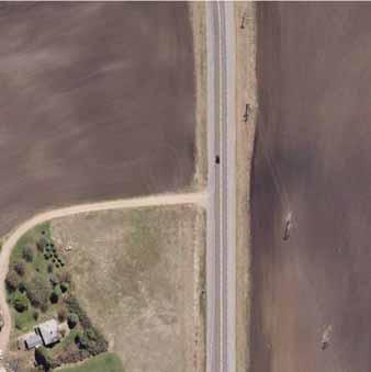
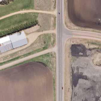
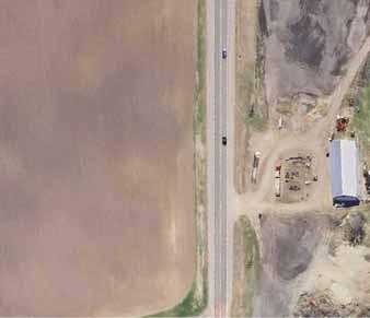
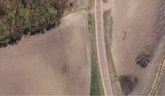
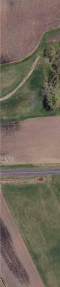
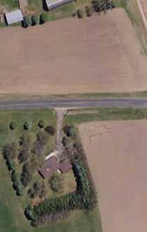
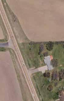
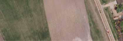
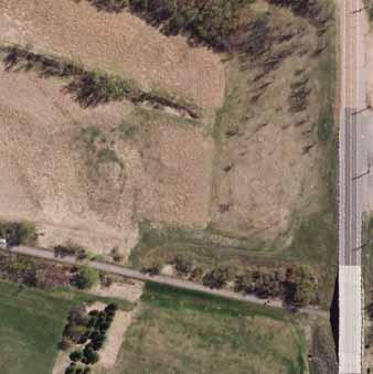
1 Information for File MVP MMJ; Reconstruction (Waconia and Watertown Townships) Applicant: Carver County Corps Contact: Melissa Jenny Address: 180 Fifth Street East, Suite 700, St. Paul, MN Phone: (651) Primary County: Carver Location: Sections 3, 10 & 15, Township 116 N., Range 25 W., and Section 34, Township 117 N., Range 25 W. Information Complete On: January 21, 2015 Posting Expires On: January 30, 2015 Authorization Type: LOP-05-MN This application is being reviewed in accordance with the practices for documenting Corps jurisdiction under Sections 9 & 10 of the Rivers and Harbor Act of 1899 and Section 404 of the Clean Water Act identified in Regulatory Guidance Letter We have made a preliminary determination that the aquatic resources that would be impacted by the proposed project are regulated by the Corps of Engineers under Section 404 of the Clean Water Act. Our jurisdictional review and final jurisdictional determination could result in modifications to the scope of the project s regulated waterbody/wetland impacts and compensatory mitigation requirements identified above. Any approved jurisdictional determination made prior to reaching a permit decision will be posted on the St. Paul District web page at Project Description and Purpose (as stated by the applicant): Carver County is proposing to reconstruct 3.2 miles of County State Aid Highway (CSAH) 10, from CSAH 30 (Waconia Township) to Trunk Highway (TH) 7 (Watertown Township), in order to improve vehicle, pedestrian and bicyclist safety and to meet current design standards. The project would involve widening the existing 4-foot gravel shoulders to 10- foot paved shoulders and upgrading to a 10-ton facility. Turn lanes would be added at West Shoreline Drive, North Shore Road and 62 nd Street. The project would also facilitate a connection to the Dakota Rail Regional Trail, including construction of a new parking lot for trail users. The project would result in the discharge fill material into acres of wetland, as detailed below and on the attached figures. 1
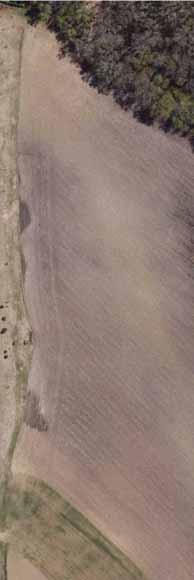
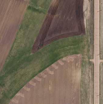
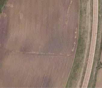
2 Name, Area and Types of Waters (Including Wetlands) Subject to Loss: Aquatic Resource ID Wetland Community Type of Impact Size of Impact Duration of Impact W-5 Wet Meadow/Shallow Marsh Fill acre Permanent W-7 Wet Meadow Fill acre Permanent W-H Wet Meadow Fill acre Permanent W-J Wet Meadow Fill acre Permanent W-8 Wet Meadow Fill acre Permanent Total Impacts acre Alternatives Considered (as stated by the applicant): Alternative #1: No-Build Alternative Under the No Build Alternative, would not be reconstructed. The crash history/safety issues associated with this segment of would not be addressed, the 4-foot gravel shoulders would not be widened to provide acceptable recovery/clear zones, and horizontal and vertical deficiencies would not be improved. This alternative was dismissed because it does not meet the project purpose and need. Alternative #2: Avoidance Alternative There are no practicable alternatives which meet the project purpose that would not have wetland impacts. Alternative #3: Reconstruction on New Alignment The project is being reconstructed on the existing alignment. Construction on a new location would not improve the existing roadway deficiencies and would likely result in greater environmental and social impacts compared to reconstruction on existing alignment, including property acquisitions and utility relocations. Alternative #4: Reconstruction with Off-Road Trail A separated off-road bicycle trail was considered, but is not proposed as part of the project to avoid additional property and wetland impacts. Carver County will consider adding a trail in the future, but the trail would be constructed as a separate project. Compensatory Mitigation: The applicant has proposed to compensate for unavoidable permanent wetland impacts associated with the safety related portions of this project (0.385 acre) at a 2:1 ratio through the Board of Water and Soil Resources (BWSR) Local Road Replacement Program. The applicant has proposed to compensate for unavoidable permanent wetland impacts associated with the non-safety related portions of this project (0.131 acre) at a 2:1 ratio via purchase of wetland bank credits from a Corps approved wetland bank located within the same major watershed as the impact site Drawings: attached and labeled as MMJ, Posting figures

3 Page 1 of 11 Hennepin Anoka Ramsey Washington SP END «7 Carver Project Location Scott Dakota Watertown Township Waconia Township ") 10 Project Limits ") 30 SP START J:\Maps\8231\mxd\Fig01 - Project Location.mxd 0 1,250 2,500 5,000 Feet Service Layer Credits: Sources: Esri, DeLorme, NAVTEQ, TomTom, Intermap, increment P Corp., GEBCO, USGS, FAO, NPS, NRCAN, GeoBase, IGN, Kadaster NL, Ordnance Survey, Esri Japan, METI, Project Location Reconstruction Project SP Carver County Figure 1
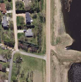
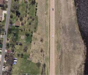
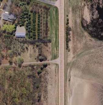
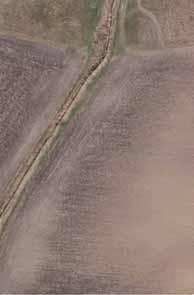
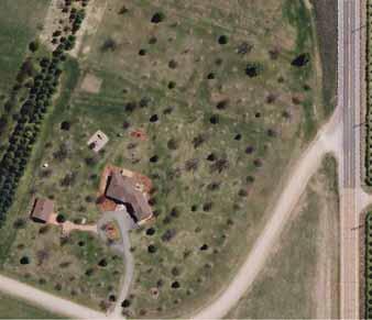
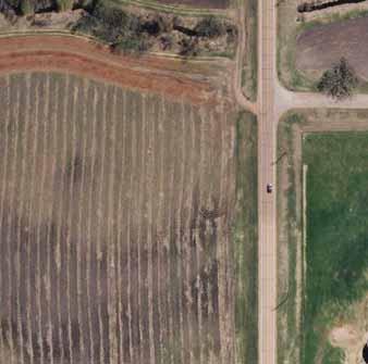
4 Page 2 of 11 Hennepin Anoka Ramsey Washington SP END «7 Carver Project Location Scott Dakota Watertown Township Waconia Township ") 10 Project Limits ") 30 J:\Maps\8231\mxd\Fig02 - Existing Conditions - Aerial Photograph.mxd 0 1,250 2,500 5,000 Feet SP START Service Layer Credits: Source: Esri, i-cubed, USDA, USGS, AEX, GeoEye, Getmapping, Aerogrid, IGN, IGP, and the GIS User Community Existing Conditions - Aerial Photograph Reconstruction Project SP Carver County Figure 2

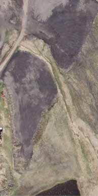
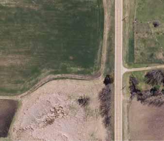
5 10/14/2014-7:53PM MVP MMJ Page 3 of 11 Figure 3A H:\Projects\8231\CAD_BIM\Graphics\8231-WETLAND-IMPACTS.dwg : FIG 3A


6 Page 4 of 11 W AC. IMPACT H:\Projects\8231\CAD_BIM\Graphics\8231-WETLAND-IMPACTS.dwg : FIG 3B 10/14/2014-7:55PM Figure 3B


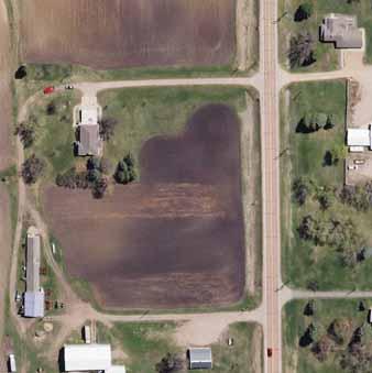
7 Page 5 of 11 W AC. IMPACT H:\Projects\8231\CAD_BIM\Graphics\8231-WETLAND-IMPACTS.dwg : FIG 3C 10/14/2014-7:57PM Figure 3C

")
8 Page 6 of 11 W AC. (SAFETY) H:\Projects\8231\CAD_BIM\Graphics\8231-WETLAND-IMPACTS.dwg : FIG 3D 10/14/2014-7:59PM Figure 3D

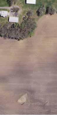
9 Page 7 of 11 W-J AC. (NON-SAFETY) H:\Projects\8231\CAD_BIM\Graphics\8231-WETLAND-IMPACTS.dwg : FIG 3E W-I AC. IMPACT 10/14/2014-8:01PM Figure 3E


10 Page 8 of 11 W-H AC. (SAFETY) H:\Projects\8231\CAD_BIM\Graphics\8231-WETLAND-IMPACTS.dwg : FIG 3F 10/14/2014-8:05PM Figure 3F

")

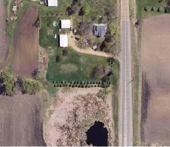
11 Page 9 of 11 W-7 W AC. (SAFETY) H:\Projects\8231\CAD_BIM\Graphics\8231-WETLAND-IMPACTS.dwg : FIG 3G 10/14/2014-8:08PM Figure 3G


12 Page 10 of 11 W AC. IMPACT W AC. (SAFETY) H:\Projects\8231\CAD_BIM\Graphics\8231-WETLAND-IMPACTS.dwg : FIG 3H 10/14/2014-8:11PM Figure 3H


13 Page 11 of 11 W AC. IMPACT W-5 SEE FIGURE 3H H:\Projects\8231\CAD_BIM\Graphics\8231-WETLAND-IMPACTS.dwg : FIG 3I 10/14/2014-8:13PM Figure 3I
Information for File # MMJ; Methodist Hospital Flood Storage Mitigation and Wetland Enhancement Project
 Information for File # 2016-01223-MMJ; Methodist Hospital Flood Storage Mitigation and Wetland Enhancement Project Applicant: Park Nicollet, Attn: Robert Riesselman Corps Contact: Melissa Jenny Address:
Information for File # MVP MMJ
 Information for File # MVP-218-477-MMJ Applicant: City of Rogers Corps Contact: Melissa Jenny Address: 18 Fifth Street East, Suite 7, St. Paul, MN 5511-1648 E-Mail: Melissa.m.jenny@usace.army.mil Phone:
Information for File # SEK
 Information for File # Applicant: Dane County Corps Contact: Simone Kolb Address: 20711 Watertown Rd., Suite F, Waukesha, WI, 53186 E-Mail: simone.e.kolb@usace.army.mil Phone: 262-717-9539 Primary County:
Option 7A Alignment Map. 100-year Floodplain with or without Project
 1-year Floodplain with or without Project New 1-year Floodplain with Project 1-year Floodplain Removed with Project i.e., Benefitted Area) Option 7A Alignment increment P 37ft Corp., GEBCO, USGS,Town FAO,
Information for File MMJ Main Stem Bassett Creek Restoration Project
 Information for File 2013-03866-MMJ Main Stem Bassett Creek Restoration Project Applicant: Minneapolis Park and Recreation Board (MPRB) Corps Contact: Melissa Jenny Address: Corps of Engineers, St. Paul
Information for File # MVP MMJ; Elim Care
 Information for File # MVP-217-2628-MMJ; Elim Care Applicant: Elim Care of Maple Plain Corps Contact: Melissa Jenny Address: 18 Fifth Street East, Suite 7, St. Paul, MN 5511-168 E-Mail: Melissa.m.jenny@usace.army.mil
Information for File # MHK
 Information for File #2014-03555-MHK Applicant: Corps Contact: Wimmer Communities Marie Kopka Address: 250 N. Sunnyslope Road, Suite 296 Brookfield, Wisconsin 53005 E-Mail: Marie.H.Kopka@usace.army.mil
Information for File # ARC
 Information for File # 2017-03115-ARC Applicant Consultant Corps Contact Bob Manzoline St. Louis and Lake Counties Regional Rail Authority Natalie White Short Elliot Hendrickson (SEH) Inc. Andrew R Chambers
Information for File # JTF
 Information for File # 2013-04665-JTF Applicant Corps Contact Enbridge Energy, Limited Partnership Josh Fitzpatrick Address 1554 Highway 2, Suite 2, Two Harbors, MN 55616 E-Mail joshua.t.fitzpatrick@usace.army.mil
Information for File # MMW
 Information for File #07-0870-MMW Applicant: Menards (Tyler Edwards) Corps Contact: Mariah Weitzenkamp Address: 80 Fifth Street East, Suite 700, Saint Paul, MN 0-78 E-Mail: Mariah.M.Weitzenkamp@usace.army.mil
Information for File # ARC
 Information for File # 2017-00054-ARC Applicant Consultant Corps Contact Linda Keith City of Tower Natalie White SEH Inc. Andrew R Chambers Address 600 South Lake Avenue, Suite 211, Duluth, MN 55802 E-Mail
In November and December, SACOG staff conducted the following Blueprint Implementation land use activities:
 SACOG Board of Directors Item #18-1-16 Receive & File January 11, 2018 Blueprint Implementation Activities The purpose of this item is to regularly inform the Board of SACOG land use related activities
Information for File #MVP MVM
 Information for File #MVP-2004-02804-MVM Applicant: St. Michael MF, LLC Corps Contact: Marissa Merriman Address: 180 Fifth Street East, Suite 700, St. Paul, Minnesota 55101-1678 E-Mail: Marissa.V.Merriman@usace.army.mil
water resource specialists
 Vaughn Collins, PE, CFM, Northwest Hydraulic Consultants Brad Livingston, Oregon Department of Transportation Melissa Reich, North Coast Land Conservancy Location Necanicum River 75 sq mi watershed Active
Transportation Impact Study Technical Working Group (TISTWG) July 1, 2015 Meeting #10 1:30-3:30 PM Agenda
 July 1, 2015 Meeting #10 1:30-3:30 PM Agenda") Transportation Impact Study Technical Working Group (TISTWG) July 1, 2015 Meeting #10 1:30-3:30 PM Agenda 1) Final review and comment on Pro-Rata Share Approach 2) Summary and status of LATR Concepts moving
Transportation Impact Study Technical Working Group (TISTWG) July 1, 2015 Meeting #10 1:30-3:30 PM Agenda 1) Final review and comment on Pro-Rata Share Approach 2) Summary and status of LATR Concepts moving
JOINT PUBLIC NOTICE. 26 June United States Army Corps of Engineers State of Louisiana
 JOINT PUBLIC NOTICE 26 June 2017 United States Army Corps of Engineers State of Louisiana New Orleans District Department of Environmental Quality Regulatory Branch Office of Environmental Services 7400
Information for File # ARC
 Information for File # 2016-02630-ARC Applicant Corps Contact Will Bomier-Carlton County Transportation Department Andrew R Chambers Address 600 South Lake Avenue, Suite 211, Duluth, MN 55802 E-Mail Andrew.R.Chambers@usace.army.mil
I-494 Rehabilitation Project SP (I-394 to Fish Lake Interchange) June 2014 Section 4(f) De Minimis Determination
 June 2014 Section 4(f) De Minimis Determination") I-494 Rehabilitation Project SP 2785-330 (I-394 to Fish Lake Interchange) June 2014 Section 4(f) De Minimis Determination State Project Number 2785-330 Federal Project No. NHPP-I494 (002) Trunk Highway:
I-494 Rehabilitation Project SP 2785-330 (I-394 to Fish Lake Interchange) June 2014 Section 4(f) De Minimis Determination State Project Number 2785-330 Federal Project No. NHPP-I494 (002) Trunk Highway:
Information for File #MVP DAS
 Information for File #MVP201702209DAS Applicant: HyVee, Inc. Corps Contact: David Studenski Address: 1114 South Oak Street, La Crescent, Minnesota 559471560 EMail: david.a.studenski@usace.army.mil Phone:
Information for File # KDZ
 Information for File # 016-098-KDZ Applicant: Wisconsin Department of Transportation Corps Contact: Kyle Zibung Address: 96 Post Road, Suite B, Stevens Point, WI 4467 -Mail: kyle.d.zibung@usace.army.mil
November 2, 2015 at 5:15pm City Council Chambers, 3rd Floor, City Hall, 1737 Main Street Columbia, South Carolina 29201
 Subject Property: PLANNING COMMISSION SITE/SUBDIVISION PLAN CASE SUMMARY 10.21 ACRES, WESTSIDE OF CLIF KINDER BOULEVARD COTTAGES AT BURNSIDE FARM BURNSIDE FARMS ASSOCIATES, LLC November 2, 2015 at 5:15pm
D.M. Wills Associates Limited PARTNERS IN ENGINEERING OSIM Bridge and Culvert Inspection Program. Township of North Frontenac
 2016 OSIM Bridge and Culvert Inspection Program Township of North Frontenac D.M. Wills Project No. 16-9206 D.M. Wills Associates Limited PARTNERS IN ENGINEERING Peterborough February 2017 Prepared for:
1 foot of Sea Level Rise
 1 foot of Sea Level Rise Schools Fire Stations Law Enforcement Assisted Living Hospitals 1ft SLR 0 0.35 0.7 1.4 Miles Year 20 Poplation: the 2013 stdy A Geological Perspective U.S. Mid-Atlantic Coast a
Information for File # RMM
 Information for File #2015-00067-RMM Applicant: New Ulm Public Schools Corps Contact: Ryan Malterud Address: 180 Fifth Street East, Suite 700, St. Paul, Minnesota 55101-1678 E-Mail: ryan.m.malterud@usace.army.mil
Towne Park Estates Subdivision Phase II
 Towne Park Estates Subdivision Phase II ENVIRONMENTAL NARRATIVE October 21, 2014 Submitted to: Submitted by: Horner Environmental Professionals, Inc. 4252 Hay Road Lutz, Florida 33559 HEP TOWNE PARK ESTATES
June 14, 2017 for the June 20, 2017 Parks and Trails Commission Meeting
 105 South Fifth Avenue Suite 513 Minneapolis, MN 55401 Tel: 612-252-9070 Fax: 612-252-9077 www.landform.net TO: FROM: DATE: Corcoran Parks and Trails Commission Kendra Lindahl, Landform June 14, 2017 for
PLANNING AND NATURAL RESOURCES COMMITTEE. Public Access Conceptual Design Alternatives for the Red Barn Area of La Honda Creek Open Space Preserve
 PLANNING AND NATURAL RESOURCES COMMITTEE R-17-56 May 9, 2017 AGENDA ITEM AGENDA ITEM 2 Public Access Conceptual Design Alternatives for the Red Barn Area of La Honda Creek Open Space Preserve GENERAL MANAGER
2.0 PROJECT DESCRIPTION
 Brunswick Street Apartment Project SCEA Project Description 2.0 PROJECT DESCRIPTION 2.1 PROJECT LOCATION The proposed project is located in Daly City, San Mateo County, California (Figure 2.0-1). The project
7.0 SOCIAL, ECONOMIC, AND ENVIRONMENTAL ISSUES
 7.0 SOCIAL, ECONOMIC, AND ENVIRONMENTAL ISSUES The following list of social, economic, and environmental issues have been identified based on a preliminary inventory of resources in the project area, an
SECTION 4(f) DE MINIMIS DOCUMENTATION
 DE MINIMIS DOCUMENTATION") SECTION 4(f) DE MINIMIS DOCUMENTATION Illinois Route 60/83 IL 176 to the intersection of IL 60 (Townline Road) Lake County P-91-084-07 Mundelein Park and Recreation District Project Limit SECTION 4(f)
SECTION 4(f) DE MINIMIS DOCUMENTATION Illinois Route 60/83 IL 176 to the intersection of IL 60 (Townline Road) Lake County P-91-084-07 Mundelein Park and Recreation District Project Limit SECTION 4(f)
City of Coquitlam Parkland Management Framework
 City of Coquitlam land Management Framework Coquitlam s land Management Framework The City of Coquitlam currently manages approximately 955 hectares (2,359 acres) of parkland that s about double the size
WELCOME! Four Corners and Upper Rio Grande Vulnerability Assessment Webinar Series
 WELCOME! Four Corners and Upper Rio Grande Vulnerability Assessment Webinar Series Phone audio: Dial: 866-620-8138; Passcode: 5952203# Mute your phone and turn off computer speakers (prevents echo issue).
Information for File # ARC
 Information for File # 2015-02781-ARC Applicant Corps Contact Enbridge Energy, Limited Partnership Andrew R Chambers Address 600 South Lake Avenue, Suite 211, Duluth, MN 55802 E-Mail Andrew.R.Chambers@usace.army.mil
CITY OF VACAVILLE PLANNING COMMISSION Item No. 8.A STAFF REPORT July 18, 2016 STAFF CONTACT: Amy Feagans, Contract Planner (707)
") CITY OF VACAVILLE PLANNING COMMISSION Item No. 8.A STAFF REPORT July 18, 2016 STAFF CONTACT: Amy Feagans, Contract Planner (707) 449-5140 TITLE: THE FARM AT ALAMO CREEK ENVIRONMENTAL IMPACT REPORT (EIR)
CITY OF VACAVILLE PLANNING COMMISSION Item No. 8.A STAFF REPORT July 18, 2016 STAFF CONTACT: Amy Feagans, Contract Planner (707) 449-5140 TITLE: THE FARM AT ALAMO CREEK ENVIRONMENTAL IMPACT REPORT (EIR)
City of Pittsburg: Billboard Corridor Study
 City of Pittsburg: Billboard Corridor Study Prepared for: City of Pittsburg Economic Development Department 65 Civic Avenue Pittsburg, California 94565-3814 Prepared by: Stantec Consulting Services Inc.
Chapter 15. Recreation
 Chapter 15. Recreation This chapter evaluates the potential impacts of the two CWP alternatives on recreational facilities, including parks, located in the Program Area. This chapter describes recreational
FIGURE ELECTRA LAKE TOPOGRAPHIC SITE LOCATION MAP
 PROJECT LOCATION: Township 39 North, Range 25 West, NW¼NW¼ Section 25, NE¼SE¼ Section 26; New Mexico Principal Meridian La Plata County, Colorado. COLORAO Centroid (NA 1983): Latitude: 37.53243 Longitude:
.404 acres (approximately 17,600 square feet) Existing Zoning
 Existing Zoning") COMMUNITY DEVELOPMENT DEPARTMENT Planning and Zoning Division 1725 Reynolds Street, Suite 200, Brunswick, GA 31520 Phone: 912-554-7428/Fax: 1-888-252-3726 BOARD OF COMMISSIONERS STAFF REPORT October 25,
COMMUNITY DEVELOPMENT DEPARTMENT Planning and Zoning Division 1725 Reynolds Street, Suite 200, Brunswick, GA 31520 Phone: 912-554-7428/Fax: 1-888-252-3726 BOARD OF COMMISSIONERS STAFF REPORT October 25,
Public Hearing. Charlotte County-Punta Gorda MPO - Meeting Rooms A and B March 14, open house at 4 p.m., formal presentation at 5 p.m.
 Public Hearing Charlotte County-Punta Gorda MPO - Meeting Rooms A and B March 14, 2019 open house at 4 p.m., formal presentation at 5 p.m. Welcome to the Public Hearing for the Harborview Road (CR 776)
ARGENTA TRAIL (CSAH 28/63) REALIGNMENT SOUTH PROJECT (CP 63-25)
 REALIGNMENT SOUTH PROJECT (CP 63-25)") ARGENTA TRAIL (CSAH 28/63) REALIGNMENT SOUTH PROJECT (CP 63-25) Preliminary Design Report February 2015 Prepared For: City of Inver Grove Heights Dakota County Prepared By: Kimley-Horn and Associates,
ARGENTA TRAIL (CSAH 28/63) REALIGNMENT SOUTH PROJECT (CP 63-25) Preliminary Design Report February 2015 Prepared For: City of Inver Grove Heights Dakota County Prepared By: Kimley-Horn and Associates,
Public Information Centre. Welcome
 Transportation Improvements from the Beaver Creek Bridge to the Entrance of Santa s Village District of Muskoka Municipal Class Environmental Assessment Welcome Please sign in Take a comment sheet Staff
National Register of Historic Places Continuation Sheet
 NPS Form 10-900-a (Rev. 8/2002) OMB No. 1024-0018 (Expires 5-31-2012) United States Department of the Interior National Park Service National Register of Historic Places Continuation Sheet Bridge No. 5721
Public Notice. Applicant: The City of Fort Worth Permit Application No.: SWF Date: June 6, 2014
 Public Notice Applicant: The City of Fort Worth Permit Application No.: SWF-2008-00264 Date: June 6, 2014 The purpose of this public notice is to inform you of a proposal for work in which you might be
UNIVERSITY OF CALIFORNIA, SAN DIEGO
 UNIVERSITY OF CALIFORNIA, SAN DIEGO BERKELEY DAVIS IRVINE LOS ANGELES MERCED RIVERSIDE SAN DIEGO SAN FRANCISCO SANTA BARBARA SANTA CRUZ PHYSICAL AND COMMUNITY PLANNING Tel. (858) 534-6515 9500 Gilman Drive
Coast & Creek Cleanup Cordelia American Canyon Creek
 Rodriguez High School Oakbrook Dr. & Silverado Dr. G:\EnvironmentalComplaince\..\SiteMap_LowerUnionCreek.mxd Cordelia American Canyon Creek Scandia Dan Wilson Creek Subway End of Lookout Hill Rd. off Central
Mississippi Skyway Preliminary Engineering Report
 EXECUTIVE SUMMARY Mississippi Skyway Preliminary Engineering Report CITY OF RAMSEY, MINNESOTA DECEMBER 2014 City of RAMSEY EXECUTIVE SUMMARY Project Need and Intent The Mississippi Skyway pedestrian bridge
1. Project Description
 To: By: Checked By: Jimmy Vilce, E.I. (FOT istrict 1 Project Manager) Jennifer Nunn, P.E. (The Balmoral Group) Lori Stanfill, P.E. (The Balmoral Group) Memorandum ate: July 10, 2018 Subject: In May of
Legend. Miles. Fence Removal Location Map for Powdermill 2 and 3. Powdermill Rehab 3 Powdermill Rehab 2 PGC_Roads SGL_Boundary
 ¹ Fence Removal N40.3580 W79.0374 Fence Removal Location Map for Powdermill 2 and 3 SGL 042 Compartment: 2 Cover Stand: 46, 68 Westmoreland County St. Clair Township Hipchain Perimeter 8990 Ft. 42 acres
PROJECT BACKGROUND. Preliminary Design Scope and Tasks
 PROJECT BACKGROUND Preliminary Design Scope and Tasks The purpose of this Study is the development of preliminary designs for intersection improvements for Trunk Highway (TH) 36 at the intersections of
2040 Long Range Transportation Plan
 2040 Long Range Transportation Plan Adopted: April 15, 2013 APPENDIX D HIGHWAY NEEDS PLAN PROJECTS FREDERICKSBURG Existing and Committed Projects Fall Hill Avenue/Mary Washington Blvd. (Fredericksburg)
ORDINANCE NO.:
 ORDINANCE NO.: 2016-003 Granting encroachment to Lisa Hosti for installation and maintenance of an ornamental iron fence within the right of way area of the 2300 block of Blossom Street adjacent to her
Welcome. Northern Segment of Hwy 100 I-90 to South of Madison Street Meeting Goals:
 Welcome Northern Segment of Hwy 100 I-90 to South of Madison Street Meeting Goals: - Review Environmental Assessment - Share Preferred Alternative -Receive Public Comments 2003 EA Preferred Alternative
CITY OF SNELLVILLE GREENWAY MASTER PLAN
 CITY OF SNELLVILLE GREENWAY MASTER PLAN NOVEMBER 2017 This page intentionally left blank. INTRODUCTION Greenways are a hot topic in planning and urbanism circles. Many communities across Georgia and the
16-198/ W16-18 Erosion Control, Wetland Protection, Waterbody Crossings & Structures, & Stormwater Management Irwin Jacobs ity of Orono
 Permit Application No.: 16-198/ W16-18 Rules: Erosion Control, Wetland Protection, Waterbody Crossings & Structures, & Stormwater Management Applicant: Irwin Jacobs/ City of Orono Received:4/26/2016 Project:
Public Meeting. US Highway 14 (6TH Street) from Main Ave to Medary Ave Urban Reconstruction Project Brookings, SD P-PH 0014(179)419 PCN 027B
 from Main Ave to Medary Ave Urban Reconstruction Project Brookings, SD P-PH 0014(179)419 PCN 027B") Public Meeting US Highway 14 (6TH Street) from Main Ave to Medary Ave Urban Reconstruction Project Brookings, SD P-PH 0014(179)419 PCN 027B Mark Leiferman Chief Road Design Engineer April 28, 2014 Why
Public Meeting US Highway 14 (6TH Street) from Main Ave to Medary Ave Urban Reconstruction Project Brookings, SD P-PH 0014(179)419 PCN 027B Mark Leiferman Chief Road Design Engineer April 28, 2014 Why
ITS Concept Development Activity Descriptions
 ITS Concept Development Activity Descriptions October 2015 Procedures are subject to change without notice. Check the NJDOT website to ensure this is the current version. Table of Contents Concept Development
Snail Lake Overflow/Grass Lake Optimization Studies. May 2, Ramsey-Washington Metro Watershed District.
 Snail Lake Overflow/Grass Lake Optimization Studies May 2, 2018 Ramsey-Washington Metro Watershed District. Purpose Purpose: 1. Summarize what s been done 2. Update board on cost vs. benefits of various
APPROVED JURISDICTIONAL DETERMINATION FORM U.S. Army Corps of Engineers
 APPROVED JURISDICTIONAL DETERMINATION FORM U.S. Army Corps of Engineers This form should be completed by following the instructions provided in Section IV of the JD Form Instructional Guidebook. SECTION
January 8, Sean Fairfield Odell Wind Farm, LLC C/o Algonquin Power Co. 354 Davis Road Oakville, Ontario L6J 2X1 Canada
 engineering planning environmental construction 71 Xenia Avenue South Suite 3 Minneapolis, MN 55416 Tel: 763-541-48 Fax: 763-541-17 January 8, 215 Sean Fairfield Odell Wind Farm, LLC C/o Algonquin Power
This chapter describes the purpose of the Plan, introduces how the Plan is organized and provides contextual background for the Plan.
 Chapter 1: INTRODUCTION Purpose of a Comprehensive Plan The 2040 Comprehensive Plan establishes Medina s vision as a community and sets goals and objectives which guide future decisions and policies. The
Welcome to the. Open House
 Welcome to the 5th Street to Kinsman Road Open House November 14 5:30 7:00 p.m. Please sign in Project Overview In December 2016, City Council adopted SW 5th Street as the preferred alignment to connect
Master Plan Amendment and Zone Change for Pyramid/La Posada Commercial
 Master Plan Amendment and Zone Change for Pyramid/La Posada Commercial Submitted to Washoe County September 15, 2014 Prepared for Pyramid Urban Achievers 555 So. Center Street Reno, NV 89501 Prepared by
TRAIL MASTER PLAN DRAFT. Broken Bow, Nebraska Adopted: Month, JEO Project No.:
 TRAIL MASTER PLAN DRAFT Broken Bow, Nebraska Adopted: Month, 2017 JEO Project No.: 161982.00 City of Broken Bow Mayor Cecil Burt City Council Members Rod Sonnichsen, President Neal Neth Chris Myers Jacob
Welcome to the BC Hydro public open house
 Welcome to the BC Hydro public open house West Transmission Project We re here to share the most recent project information and to gather your comments on what we know so far. We hope you ll share your
1.0 INTRODUCTION 1.1 TH 14 WEST STUDY AREA Project Description Functional Classification Purpose of the Project
 1.0 INTRODUCTION 1.1 TH 14 WEST STUDY AREA 1.1.1 Project Description The Trunk Highway (TH) 14 West Corridor is a two-lane roadway approximately 22 miles in length. Located in Nicollet County, the corridor
AGENDA ITEM: IOWA. west] that were not FISCAL IMPACT. the City of Clive. STAFF REVIEW. Resolution II. Amendment PREPARED BY: REVIEWED BY:
![AGENDA ITEM: IOWA. west] that were not FISCAL IMPACT. the City of Clive. STAFF REVIEW. Resolution II. Amendment PREPARED BY: REVIEWED BY:](/thumbs/93/112428810.jpg "AGENDA ITEM: IOWA. west] that were not FISCAL IMPACT. the City of Clive. STAFF REVIEW. Resolution II. Amendment PREPARED BY: REVIEWED BY:") AGENDA ITEM: CITY OF WAUKEE, IOWA CITY COUNCIL MEETING COMMUNICATION MEETING DATE: March 7, 2016 AGENDA ITEM: Consideration of approval of a resolution approving Engineering Services Amendment No. 1 with
AGENDA ITEM: CITY OF WAUKEE, IOWA CITY COUNCIL MEETING COMMUNICATION MEETING DATE: March 7, 2016 AGENDA ITEM: Consideration of approval of a resolution approving Engineering Services Amendment No. 1 with
Dayton Transportation Plan 2016 Update
 WENCK File #3164-30 February 9, 2016 Dayton Transportation Plan 2016 Update Prepared for: City of Dayton, MN 12260 S. Diamond Lake Road Dayton, MN 55327 Prepared by: WENCK Associates, Inc. 1800 Pioneer
Saranac River Trail Greenway C O N D I T I O N S R E P O R T
 Saranac River Trail Greenway C O N D I T I O N S R E P O R T City of Plattsburgh Clinton County, NY For: Clinton County Final Issued: March 22, 2017 This document was prepared for the New York State Department
Decision Notice. Proposed Action
 Decision Notice Paving Weld County Road 105 USDA Forest Service Arapaho and Roosevelt National Forest and Pawnee National Grassland Pawnee National Grassland Ranger District Weld County, Colorado November
Public Notice ISSUED: 7/30/2018 EXPIRES: 8/29/2018
 SPONSOR: Mark Prosser Public Notice ISSUED: 7/3/218 EXPIRES: 8/29/218 REFER TO: MVP-216-1916-LSP SECTION:44 - Clean Water Act 1. WETLAND COMPENSATORY MITIGATION BANK PROPOSAL 2. SPECIFIC INFORMATION SPONSOR
Watertown City Council
 City of Watertown Watertown City Council April 14 th, 2015 Agenda Item: City Comment on Sun Share CUP Application Request for Action: Motion to Approve City Comments regarding CUP Application Department:
Northeast Anthony Henday Drive Manning Freeway to Whitemud Drive Welcome to this Construction Information Session
 Manning Freeway to Whitemud Drive Welcome to this Construction Information Session Purpose To inform interested residents and businesses about the plans accommodation. Background: The Government of Alberta
ME DOT Route 3. File No.: City and State: Bar Harbor, ME
 ME DOT Route 3 File No.: 199600361 City and State: Bar Harbor, ME General Impacts: 0.28 acre tidal emergent 0.77 acre non-tidal forested 0.15 acre non-tidal emergent 0.51 acre non-tidal scrub-shrub Functions
Wallace Country Acreage
 Wallace Country Acreage A stunning brick home surrounded by beautiful landscaping and picturesque views of the Nebraska plains Email: Jordan@lashleyland.com Property Highlights List Price $500,000 Location
PROJECT STATEMENT LOCATION/DESIGN PUBLIC HEARING. 19 th AVENUE NORTH EXTENSION PROJECT FROM SPRINGDALE DRIVE TO NORTH 2 ND STREET/U.S.
 PROJECT STATEMENT LOCATION/DESIGN PUBLIC HEARING 19 th AVENUE NORTH EXTENSION PROJECT FROM SPRINGDALE DRIVE TO NORTH 2 ND STREET/U.S. 67 HEARING LOCATION: ERICKSEN COMMUNITY CENTER 1401 11 TH AVENUE NORTH
Capital Projects in and near Odenton Town Center
 Capital Projects in and near Odenton Town Center Map ID Anne Arundel County Department of Public Works This project provides for the design, right of way acquisition, and construction of approximately
Transportation Research Center
 Increasing Design Flexibility in the AASHTO Green Book Your Department Name Presentation to AASHTO Subcommittee on Design Doug Harwood, MRIGlobal July 2017 Transportation Research Center Resolution of
Northern Branch Corridor SDEIS March 2017
 Northern Branch Corridor SDEIS March 2017 15. 15.1. Chapter Overview 15.1.1. Introduction This chapter discusses changes to the Preferred Alternative resulting in the potential for project improvements
REQUEST FOR PROPOSAL. Elkhorn Slough Tidal Marsh Restoration. Final Design, Bid Oversight and Construction Administration
 REQUEST FOR PROPOSAL Elkhorn Slough Tidal Marsh Restoration Final Design, Bid Oversight and Construction Administration Issue Date: October 13, 2016 Pre-Proposal Site Tour October 27, 2016 2:00 pm Return
Infrastructure Engineering Planning Construction Suite 300 Minneapolis, MN Tel: Fax:
 Infrastructure Engineering Planning Construction 701 Xenia Avenue outh uite 300 Minneapolis, MN 55416 Tel: 763-541-4800 Fax: 763-541-1700 Memorandum To: Minnehaha Creek Watershed District Board From: Tony
CATEGORICAL EXCLUSION DETERMINATION I 435/I 35/K 10 INTERCHANGE (JOHNSON COUNTY GATEWAY)
") December 11, 2012 CATEGORICAL EXCLUSION DETERMINATION I 435/I 35/K 10 INTERCHANGE (JOHNSON COUNTY GATEWAY) Project Number: Kansas Department of Transportation (KDOT) Project No. 435-46 KA-1002-03 Route:
December 11, 2012 CATEGORICAL EXCLUSION DETERMINATION I 435/I 35/K 10 INTERCHANGE (JOHNSON COUNTY GATEWAY) Project Number: Kansas Department of Transportation (KDOT) Project No. 435-46 KA-1002-03 Route:
DRAFT SECTION 4(F) EVALUATION KOLLINER PARK
 EVALUATION KOLLINER PARK") DRAFT SECTION 4(F) EVALUATION I. DESCRIPTION OF SECTION 4(F) RESOURCE The Section 4(f) resource potentially affected by the proposed action is Kolliner Park. The Alternative B-1 and C bridge crossings
DRAFT SECTION 4(F) EVALUATION I. DESCRIPTION OF SECTION 4(F) RESOURCE The Section 4(f) resource potentially affected by the proposed action is Kolliner Park. The Alternative B-1 and C bridge crossings
Pennsy Greenway Trail
 Town of Schererville Pennsy Greenway Trail DES. #s: 0401062, 1173595 & 1382661 Construction of Pennsy Greenway Trail beginning at Wilhelm Street and continuing northwest along the former Penn Central railroad
1.0 EXECUTIVE SUMMARY
 1.0 EXECUTIVE SUMMARY The Minnesota Department of Transportation (Mn/DOT) proposes to make capacity improvements to the interregional corridor (IRC) connection between Interstate 94 (I-94) and Trunk Highway
7.0 DRAFT SECTION 4(f) EVALUATION
 EVALUATION") 7. DRAFT SECTION 4(f) EVALUATION 7.1 Background Information and Regulatory Requirements This chapter presents the existing conditions and potential effects on parks, recreation areas, wildlife and waterfowl
7. DRAFT SECTION 4(f) EVALUATION 7.1 Background Information and Regulatory Requirements This chapter presents the existing conditions and potential effects on parks, recreation areas, wildlife and waterfowl
Rezoning Transportation Analysis Petition Number: General Location Identifier:
 From: Kelsie Anderson, PE Kelsie.Anderson@charlottenc.gov 704-432-5492 Staff Reviewer: Kory Hedrick, PE, PMP Khedrick@charlottenc.gov 704-432-6511 CDOT s review of this rezoning petition is intended to
Environmental Impact Assessment (EIA)
") Environmental Impact Assessment (EIA) In December 2016 the states Assembly decided that a new general hospital for Jersey should be built on part of the site of the existing hospital in the centre of St
Environmental Impact Assessment (EIA) In December 2016 the states Assembly decided that a new general hospital for Jersey should be built on part of the site of the existing hospital in the centre of St
Gold Line Bus Rapid Transit Transit Oriented Development (BRTOD) Helmo Station Area Plan
 Helmo Station Area Plan") Appendix F Gold Line Bus Rapid Transit Transit Oriented Development (BRTOD) Helmo Station Area Plan Introduction and Purpose of the Plan The Gold Line Bus Rapid Transit facility is an eleven-mile dedicated
Appendix F Gold Line Bus Rapid Transit Transit Oriented Development (BRTOD) Helmo Station Area Plan Introduction and Purpose of the Plan The Gold Line Bus Rapid Transit facility is an eleven-mile dedicated
Highway 427 Industrial Secondary Plan Area 47 Schedule C Class Environmental Assessment For Arterial Roadways
 Welcome to Pubic Information Centre #1 Highway 427 Industrial Secondary Plan Area 47 Schedule C Class Environmental Assessment For Arterial Roadways Welcome to Open House # 1 Tonight, we invite you to.
Report on Site Selection SR-0188 SR-0176 SR-0319 SR-0819 SR-0818 SR-0817 SR-0816 SR-0576 SR-0813 SR-0225 SR-0293 SR-0811 SR-0810 SR-0865
 EB81Gi SR-188 SR-176 SR-319 SR-819 SR-818 SR-817 SR-576 SR-816 SR-225 SR-813 SR-293 SR-81 SR-811 SR-865 Report on Site Selection. EFDC-S2-1-Rev1 Date: September 216 Scale: 1:12,5 @A3 Content Source: Esri,
NORTHEAST RIVER CROSSING FUNCTIONAL PLANNING STUDY
 WELCOME Northeast River Crossing Functional Planning Study Phase 2 Public Meeting 4 to 8 PM Informal drop-in format and discussion tables Meeting Purpose Introduce the Northeast River Crossing Functional
September 28, 2017 Wentworth Avenue (CR 8) Sidewalk Improvements Open House
 Sidewalk Improvements Open House") TIME Anytime from 5:00 PM to 7:00 PM LOCATION City Hall Council Chambers Learn about the project Speak with project representatives Provide input YOU RE INVITED! September 28, 2017 Wentworth Avenue (CR
TIME Anytime from 5:00 PM to 7:00 PM LOCATION City Hall Council Chambers Learn about the project Speak with project representatives Provide input YOU RE INVITED! September 28, 2017 Wentworth Avenue (CR
Mendota Heights 2040 Comprehensive Plan Draft Vers
 4 Parks and Trails The City of Mendota Heights boasts a variety of recreational and open space opportunities. Few cities can claim access to regional trails, riverside and lakeside parks, scenic bluffs
SUMMARY. Support the Southeast Arkansas Regional Intermodal Facility.
 SUMMARY THE I-69 LOCATION STUDY The proposed I-69 Location Study from El Dorado to McGehee, Arkansas, represents one section (Section of Independent Utility No. 13) of the nationally designated I-69 Corridor
Hunt Highway CELESTE PEMBERTON, CFM, CPM PINAL COUNTY CARLOS SANCHEZ SORIA, PE T.Y. LIN INTERNATIONAL
 Hunt Highway CELESTE PEMBERTON, CFM, CPM PINAL COUNTY CARLOS SANCHEZ SORIA, PE T.Y. LIN INTERNATIONAL Agenda Design Concept Report Phase 1 Phase 2 Phase 3 Phase 4 Phase 5 Questions Design Concept Report
CARVER COUNTY DIVISION OF PUBLIC WORKS LANDSCAPE POLICY. Adopted by the Carver County Board of Commissioners March 3, 2015
 CARVER COUNTY DIVISION OF PUBLIC WORKS LANDSCAPE POLICY Adopted by the Carver County Board of Commissioners March 3, 2015 Policy Statement Goals It is the goal of Carver County Public Works to provide
Description of Preferred Alternative
 Chapter 2 Description of Preferred Alternative 2.1 Introduction This chapter of the programmatic Sammamish Town Center Sub-area Plan Final EIS provides a more detailed description of the Preferred Alternative
Derby-Shelton Bridge Pedestrian and Bicyclist Enhancements [1]
![Derby-Shelton Bridge Pedestrian and Bicyclist Enhancements [1]](/thumbs/96/128011958.jpg "Derby-Shelton Bridge Pedestrian and Bicyclist Enhancements [1]") nhancements [1] STATUS OF PROJECT: The project has recently moved from the Preliminary Design Phase to the Final Design Phase following the most recent Public Involvement Meeting held on January 9, 2019
nhancements [1] STATUS OF PROJECT: The project has recently moved from the Preliminary Design Phase to the Final Design Phase following the most recent Public Involvement Meeting held on January 9, 2019
MODEL ACCESS MANAGEMENT PLAN MINNESOTA TRUNK HIGHWAY 7 COMPREHENSIVE PLAN AMENDMENT (HUTCHINSON SEGMENT)
") MODEL ACCESS MANAGEMENT PLAN MINNESOTA TRUNK HIGHWAY 7 (HUTCHINSON SEGMENT) COMPREHENSIVE PLAN AMENDMENT INTRODUCTION. The purpose of this plan is to provide consistent access management in the Trunk
MODEL ACCESS MANAGEMENT PLAN MINNESOTA TRUNK HIGHWAY 7 (HUTCHINSON SEGMENT) COMPREHENSIVE PLAN AMENDMENT INTRODUCTION. The purpose of this plan is to provide consistent access management in the Trunk
Madison County Data List December 16, 2008
 Madison County Data List December 16, 2008 This data list is current as of the date listed above. This does not imply that the datasets listed are current. Although a dataset may be listed it may not be