Docket Item "K" PLN-PUDC Jolliff Landing at Western Branch CITY COUNCIL PACKAGE FOR DECEMBER 20, 2016
|
|
|
- MargaretMargaret Skinner
- 5 years ago
- Views:
Transcription


1 Docket Item "K" PLN-PUDC Jolliff Landing at Western Branch CITY COUNCIL PACKAGE FOR DECEMBER 20, 2016 Page 1 2 Application Summary 3 20 Development Criteria dated October 18, Master Land Use Plan Planning Commission Draft Minutes Staff Report(s): November 2, Fiscal Impact Analysis Architectural Elevations 58 Aerial 59 GIS Parcel Exhibit
2
3
4 3
5 4
6 5
7 6
8 7
9 8
10 9
11 10
12 11
13 12
14 13
15 14
16 15
17 16
18 17
19 18
20 19
21 20

22 21
23 22
24 23

25 24
26 25
27 26
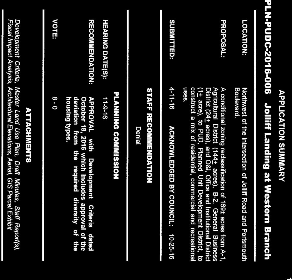
28 Chesapeake Planning Commission DRAFT November 9, 2016 Public Hearing Minutes 27 PLN-PUDC PROJECT: Jolliff Landing at Western Branch APPLICANT: Kotarides Developers LLC AGENCY: Williams Mullen PROPOSAL: A conditional zoning reclassification of 169± acres from A-1, Agricultural District (144+ acres), B-2, General Business District (24+ acres), and O&I, Office and Institutional District (1+ acre), to PUD, Planned Unit Development District, to construct a mix of residential, commercial and recreational uses. PROPOSED COMP LAND USE / DENSITY: Low Density Residential/<4 du/acre, Business/Commercial. EXISTING COMP LAND USE / DENSITY: Light Industry/Logistics; Office/Research; Business/Commercial LOCATION: Northwest of the intersection of Jolliff Road and Portsmouth Boulevard. TAX MAP SECTION/PARCELS: , , , , , portion of , portion of BOROUGH: Western Branch PLANNING COMMISSION RECOMMENDATION: Planning Commission recommends PLN-PUDC be APPROVED with development criteria dated October 18, 2016, which includes approval of the deviation from the required diversity of housing types. (8-0; Van Laethem/McCormick, Williams excused) Mrs. Shaffer read PLN-PUDC into the record for Commission review and action. Staff Presentation: Mr. McKay stated that based on the findings listed in the staff report, planning staff recommended that PLN-PUDC be DENIED. Should the Planning Commission be inclined to recommend approval and should City Council be inclined to approve the application, staff recommends the Development Criteria dated October 18, 2016, which includes approval of the deviation from the required diversity of housing types, be accepted. Proponent: Grady Palmer, Williams Mullen, 999 Waterside Drive, Norfolk, Virginia. This was a difficult project to conceive and execute. The property is situated on the north side of Portsmouth Boulevard north of Jolliff Landing Townhouse development. The project includes a single-family neighborhood with traditional design. Lowes and Cracker
29 Chesapeake Planning Commission DRAFT November 9, 2016 Public Hearing Minutes 28 Barrel retail are located east. Their vision is different from City s. They want to create a live, work, play setting truly unique to Western Branch area. Staff s recommendations are greatly appreciated, but he hopes the Commission uses a broader lens and considers the proposal. The property is heavily impacted by wetlands and the property to the north of this will not be developed due to wetland regulations. Thirty-seven acres of the Smith Farm is part of the unique economic development opportunity and 12 acres of that is wetlands subject to a delineation that will expire in Pete Burkhimer, American Engineering Associates, 448 Viking Drive, Virginia Beach, Virginia. This is a large and complex project. He has been involved in some of the most successful projects in Chesapeake. He worked with the Jim Boyd from the Smith family for 6 years and fought to bring successful conclusion with Environmental Protection Agency. He has knowledge of developing logistics projects and this property is not suitable. They are trying to revitalize the area and provide support to the Western Branch area. There are questions regarding soil conditions and storm drainage. The near surface soils can support light to medium structural loads, but deeper soft soils could not support a large heavy structure which would cause deeper soils to consolidate causing unacceptable settlements on building. Drainage is not a problem on the site since it is very close to a major drainage ravine. It will not be complicated to provide storm water management. Mark Steiner, Fran Net of Southern Virginia, 4300 Galston Court, Chesapeake, Virginia. This project provides an extraordinary opportunity for Western Branch. He s a resident of the community. He works with small businesses and the Chamber of Commerce with people starting businesses in Hampton Roads. He is trying to get the community to have great ideas and to promote the community to live, work and play. Change requires leadership, and this developer has been actively participating. This development brings jobs, foot traffic, rooftops to benefit existing businesses. This developer provides a unique way to bring this opportunity to the community. The project also provides the opportunity for a field house. Dan Hickok, RRMM Architects, 1317 Executive Blvd, Chesapeake, Virginia. This will be a neo-traditional community. Bike trails, sidewalks, outdoor activities, and promenade district will be complimentary to the residential community. This provides unique opportunity to have all 3 components: live, work, and play in the area. All of these opportunities would bring jobs and business. There are two options and plans will be flexible to what the community desires with retail and a field house or office behind.
30 Chesapeake Planning Commission DRAFT November 9, 2016 Public Hearing Minutes 29 COMMISSION DISCUSSION: Commissioner McCormick requested Mr. Palmer to return to finish his comments. Mr. Palmer stated that the City has the option of the direction they would like to go with this property. The proposed office development will provide the same number of jobs, 1500, as if using the entire property for light industrial/logistics and they will be higher paying. This project also provides an opportunity for the City to use the property for a field house or build and market City-owned office space. The project passes the level of service test for schools. A request for a deviation from the housing diversity requirement of the PUD ordinance has been submitted. The existing townhouse and apartment projects are being built by the same developer and will function with the proposed single family units as one community with diverse housing types. A sign package will create visual connectivity and tie in with all development. The Field House option includes a cash component. The developer will provide $800,000 to the City to get the project off the ground. Alternatively, the City can choose to use the same 6 acres for office development that they can market. Commissioner Ellis asked Mr. Palmer about the price points. Mr. Palmer responded that the homes are priced $350,000 and above. Commissioner Van Laethem asked Mr. Palmer in regards to the wetlands and to explain the impact of the EPA letter and June 2019 date to start and end the procedures. Mr. Palmer explained that wetland delineations are good for 5 years. Afterwards, property has to be re-delineated for another 5 years. June 2019 is the expiration date of the current Army Corps of Engineers delineation. If the delineation is not reconfirmed, the wetlands will most likely grow larger. The project phasing will be from the rear and move forward because of wetland issue. Mr. Burkhimer explained that on the Smith Farm, approximately 114 acres is useable land for single family development. Of this, 39 of the acres was part of a fierce 15-year battle with EPA. It is unlikely to get a logistics development started before the current delineation expires. It is much more likely to develop the proposed live, work, play, shop concept as proposed in this time frame. There is no opposition because the development has no neighbors. Approximately 300 acres to the northeast that is currently designated for office development on the land use plan cannot be developed due to wetlands. It makes more sense to concentrate job creation in condensed office development near Portsmouth Boulevard. Consolidating office area in front of the housing where it can be seen can help to revitalize Western Branch. The project will do well here in terms of revitalization and will help the Boyd family at the same time. They propose a change to the Master Transportation Plan to downgrade Hampton Roads Parkway from an arterial to a collector with 2 lanes similar to Edinburgh Parkway with no driveways on this road. Also, the arterial to serve the 300 acres to the north is not necessary due to the wetlands issue. The proposed development passes all LOS tests.
31 Chesapeake Planning Commission DRAFT November 9, 2016 Public Hearing Minutes 30 Commissioner Kish asked Mr. Burkhimer to describe the technical aspect of soil conditions and its relation to the use of property as designated in the comprehensive plan and to address the impact of the wetlands delineation. Mr. Burkhimer responded that there is 6 to 8 feet of competent soil as long as there is no excessive weight. Light industrial use might work but not logistics because it is a heavier use and requires deeper better soils. Heavy buildings will have settlement due to a process that forms pockets in some places causing differential settlement. If a light industrial or logistics use was interested in constructing right now, it would still take a full year of design and construction plan review; therefore, construction could not start until 2019, and the development will not be done within time frame allotted by the current wetlands delineation. Construction has to occur in 2018 to meet the June 2019 deadline. Commissioner Van Laethem asked Mr. Burkhimer to describe the Hampton Roads Parkway which goes north and ties into Bromay, which leads to Pughsville Road and the I-664 interchange. Would large trucks from Gateway Commerce Park and Luckstone come south on Hampton Roads Parkway to get to Portsmouth Boulevard? Commissioner Van Laethem also asked Mr. Burkhimer to address wetlands in this area and their effect on drainage when there is a major storm event. Mr. Burkhimer replied that it is closer to go directly to the Pughsville interchange for trucks that come from properties to the north. The Hampton Roads Parkway might provide relief during traffic jams on the I-664, but it would not be a preferred route for trucks. Also, it may be difficult to get the required wetlands permits to build the road. The design of storm drainage systems is the key to handling major storm events. It is a relatively easy engineering fix. Drainage direction splits at roughly the city line with water in Suffolk draining to the west and water in Chesapeake draining east toward the Bailey Creek Ravine, which is a natural drainage basin. He stated that there were not any drainage issues after October 8-9 storm. Commissioner Ellis asked Mr. Tate to address the applicant s comments regarding keeping Hampton Roads Parkway as an arterial, given the wetlands issues on property and north of Jolliff Landing. Mr. Tate replied that the Master Transportation Plan does not rely on wetland studies and it was developed to support the Land Use Plan. It is reasonable to consider a reduction from an arterial to a collector if wetlands are an issue. Commissioner Van Laethem asked Mr. Tate if the proximity of the traffic lights at Hampton Roads Parkway and Jolliff Landing Parkway are acceptable and will there be adequate turn lanes at these intersections. Mr. Tate responded that the Portsmouth Boulevard widening project will begin construction in early winter and will last 18 months. It will be a 4-lane roadway within a right-of-way that can accommodate 6 lanes and will have double turn lanes. Signal spacing is a little undesirable, but the locations were determined by existing land uses and there will be an adequate level of service.
32 Chesapeake Planning Commission DRAFT November 9, 2016 Public Hearing Minutes 31 Commissioner Van Laethem moved to approve PLN-PUDC with the development criteria dated October 18, 2016 and which includes approval of the deviation from the required diversity of housing types, for the following reasons: 1) the proposed PUD passes the Level of Service analysis for adequate roads, schools, and sewers; 2) the development is consistent with the surrounding uses; 3) the development is consistent with the objectives of the PUD ordinance as it provides a mix of residential, commercial and recreational uses. Commissioner McCormick seconded the motion. Commissioner Van Laethem stated that he has a desire to adhere to the Comprehensive Plan and Master Transportation Plan, but in this case, reality has an impact. Residential development is needed to support business and large new businesses will not come to the area without residential development to support them. There are viable reasons to deviate from the Plans. The Plans could be outdated. He agrees with the live, work, shop and play concept of mixed use development. He thinks that this is a prime location for such a development given its easy access to I-664. This is the time to deviate from the plan and supports motion. COMMISSION VOTE: Commissioner Van Laethem moved that PLN-PUDC be APPROVED with development criteria dated October 18, 2016, which includes approval of the deviation from the required diversity of housing types. Commissioner McCormick seconded the motion. The motion was carried by a vote of 8-0. Chairman Williams excused.
33 32

34 33
35 34
36 35
37 36
38 37

39 38
40 39

41 40

42 41
43 42

44 43
45 44
46 45
47 46
48 47
49 48
50 49

51 50
52 51
53 52
54 53

55 54

56 55
57 56

58 57

59 58
, B-2, General Business District (24+ acres), and O&I, Office and Institutional District (1+ acre) to PUD, Planned Unit Development District, to construct a mix of residential,")
60 59 PLN-PUDC Joliff Landing at Western Branch APPLICANT: Kotarides Developers LLC AGENCY: Williams Mullen PROPOSAL: A conditional zoning reclassification of 169± acres from A-1, Agricultural District (144+ acres), B-2, General Business District (24+ acres), and O&I, Office and Institutional District (1+ acre) to PUD, Planned Unit Development District, to construct a mix of residential, commercial and recreational uses. PROPOSED COMP LAND USE / DENSITY: Low Density Residential/<4 du/acre, Business/Commercial. EXISTING COMP LAND USE / DENSITY: Light Industry/Logistics; Office/Research; Business/Commercial LOCATION: Northwest of the intersection of Jolliff Road and Portsmouth Boulevard. TAX MAP SECTION/PARCELS: , , , , , portion of , portion of BOROUGH: Western Branch
Robbins Nursery CITY COUNCIL PACKAGE FOR AUGUST 18, 2015
 Docket Item "C" UP-15-19 Robbins Nursery CITY COUNCIL PACKAGE FOR AUGUST 18, 2015 Page 1 2 Application Summary 3 Planning Commission Draft Minutes 4 12 Staff Report: June 30, 2015 13 15 Site Plan 16 Aerial
ARLINGTON COUNTY, VIRGINIA. County Board Agenda Item Meeting of February 23, 2019
 ARLINGTON COUNTY, VIRGINIA County Board Agenda Item Meeting of February 23, 2019 DATE: February 15, 2019 SUBJECT: Amendment to the Master Transportation Plan (MTP) Map to add a new section of North Kansas
PLANNING COMMISSION Work Session Meeting Agenda
 PLANNING COMMISSION Work Session Meeting Agenda 5200 85TH AVENUE NORTH BROOKLYN PARK MN 55443 PHONE (763) 424-8000 FAX (763) 493-8391 Wednesday, September 27, 2017-7:00 P.M. Brooklyn Township Room If due
2.0 AREA PLANS. Lakeside Business District. Lakeside Business District Land Use Categories:
 Lakeside Business District Lakeside Business District Land Use Categories: Campus Commercial Campus Commercial means a mixture of uses which includes corporate offices, office parks, hotels, commercial,
14 October 10, 2012 Public Hearing APPLICANT: MPB, INC
 14 October 10, 2012 Public Hearing APPLICANT: MPB, INC PROPERTY OWNER: MUNDEN & ASSOCIATES, LP STAFF PLANNER: Karen Prochilo REQUEST: Conditional Change of Zoning (AG-1 & AG-2 to Conditional O-2) ADDRESS
Land Use Amendment in Southwood (Ward 11) at and Elbow Drive SW, LOC
 at and Elbow Drive SW, LOC") 2018 November 15 Page 1 of 10 EXECUTIVE SUMMARY This land use amendment application was submitted by Rick Balbi Architect on 2017 August 31 on behalf of Sable Developments Ltd, and with authorization from
2018 November 15 Page 1 of 10 EXECUTIVE SUMMARY This land use amendment application was submitted by Rick Balbi Architect on 2017 August 31 on behalf of Sable Developments Ltd, and with authorization from
REQUEST FOR COUNCIL ACTION 6A AGENDA ITEM ORIGINATING DEPT. AGENDA ITEM CITY ADMINISTRATOR APPROVAL
 DATE REQUEST FOR COUNCIL ACTION 6A AGENDA ITEM ORIGINATING DEPT. AGENDA ITEM CITY ADMINISTRATOR APPROVAL Community Development Territorial Greens PUD Concept Plan Development Stage Plan Subdivision (Preliminary
CITY-COUNTY PLANNING BOARD DRAFT STAFF REPORT
 CITY-COUNTY PLANNING BOARD DRAFT STAFF REPORT PETITION INFORMATION Docket # W-3174 Staff Aaron King Petitioner(s) O Reilly Auto Parts Owner(s) Glenn Crossing Associates, LLC Subject Property Portion of
12 January 12, 2011 Public Hearing APPLICANT: TAILWIND DEVELOPMENT GROUP,LLC PROPERTY OWNER: CITY OF VIRGINIA BEACH
 12 January 12, 2011 Public Hearing APPLICANT: TAILWIND DEVELOPMENT GROUP,LLC PROPERTY OWNER: CITY OF VIRGINIA BEACH STAFF PLANNER: Faith Christie REQUEST: Conditional Change of Zoning (from PD-H1 Planned
Staff Report and Recommendation
 Community Planning and Development Planning Services 201 W. Colfax Ave., Dept. 205 Denver, CO 80202 p: 720.865.2915 f: 720.865.3052 www.denvergov.org/cpd TO: City Council Neighborhoods and Planning Committee
REQUEST FOR COUNCIL ACTION 6A AGENDA ITEM
 DATE REQUEST FOR COUNCIL ACTION 6A AGENDA ITEM ORIGINATING DEPT. AGENDA ITEM CITY ADMINISTRATOR APPROVAL Community Development PUD Concept & Development Stage Plan Preliminary Plat & Final Plat PREVIOUS
Community Development Rezoning Report REZ14-006
 Community Development Rezoning Report REZ14-006 Planning Commission Board of Supervisors March 4, 2014 March 26, 2014 Applicant M & N Real Estate, LLC Tax Map Id 125-(A)- L20E,125-(A)- L20E1, portion of
Rezoning Petition Post-Hearing Staff Analysis July 31, 2018
 Rezoning Petition 2018-044 Post-Hearing Staff Analysis July 31, 2018 REQUEST Current Zoning: R-3 (single family residential) Proposed Zoning: UR-2(CD) (urban residential, conditional) LOCATION Approximately
Green Gables. April 24, 2013
 Green Gables Preliminary and Final Plat April 24, 2013 Development Team Green Gables Development Corporation (Owner/Developer) DTJ Design (Planner/Landscape Architect) Enertia Consulting Group (Civil Engineer)
Town of Windham. Planning Department 8 School Road Windham, ME voice fax
 Town of Windham Planning Department 8 School Road Windham, ME 04062 voice 207.864-5960 fax 207.892.1916 MEMO DATE: TO: Staff Review Committee FROM: Amanda Lessard, Planner Cc: Ellen Rathbone, St. Germain
Asbury Chapel Subdivision Sketch Plan
 Asbury Chapel Subdivision Sketch Plan PART 1: PROJECT SUMMARY Applicant: NVR Inc. Project Size: +/- 76.13 acres Parcel Numbers: 02101112,02116101,02116112, 02116113 Current Zoning: Transitional Residential
Glenn Highway MP DSR. Landscape Narrative
 Glenn Highway MP 34-42 DSR Landscape Narrative Project Landscape Goals The Glenn Highway MP 34-42 Project extends through a variety of landscape types typical to the Matanuska-Susitna Valley. In general,
Gloucester County s Comprehensive Plan. The Community Connection
 Gloucester County s Comprehensive Plan The Community Connection Current Comp Plan Adopted in 1991 with a 20 year planning horizon Updated in 1995 with Part V- Implementation Recommendations and Appendix
Mitchell Ranch South MPUD Application for Master Planned Unit Development Approval Project Narrative. Introduction
 Mitchell Ranch South MPUD Application for Master Planned Unit Development Approval Project Narrative Introduction Mitchell Ranch South is a proposed single family (detached) residential development on
AWH REPORT OF THE PLANNING AND DEVELOPMENT DEPARTMENT FOR APPLICATION FOR REZONING ORDINANCE TO PLANNED UNIT DEVELOPMENT
 AWH REPORT OF THE PLANNING AND DEVELOPMENT DEPARTMENT FOR APPLICATION FOR REZONING ORDINANCE TO PLANNED UNIT DEVELOPMENT MAY 8, 2014 The Planning and Development Department hereby forwards to the Planning
Agenda Item. Applicant Logan Virginia Properties, LLC Property Owners Byler Azalea, LLC & Gateway Free Will Baptist Chuch
 Applicant Property Owners Byler Azalea, LLC & Gateway Free Will Baptist Chuch Public Hearing March 14, 2018 City Council Election District Kempsville Agenda Item 6 Request Conditional Rezoning (B-2 Community
Baumgarten MPUD. Exhibit 3 Evaluation Criteria
 Pursuant to LDC subsections 10.02.13 B, 10.02.08 F and Chapter 3 G. of the Administrative Code, staff s analysis and recommendation to the Planning Commission, and the Planning Commission s recommendation
SYRINGA VALLEY SPECIFIC PLAN NARRATIVE
 SYRINGA VALLEY SPECIFIC PLAN NARRATIVE Introduction With this application, Pleasant Valley South LLC ( Pleasant Valley ) seeks the City of Boise s approval of a new Specific Plan Ordinance to be added
Secrest Short Cut and Monroe Expressway Small Area Plan AUGUST 29, 2018
 Secrest Short Cut and Monroe Expressway Small Area Plan AUGUST 29, 2018 Background and Process Monroe Expressway will be open by the end of 2018 Union County and Indian Trail identified a need to revisit
Drexel, Barrell & Co.
 Drexel, Barrell & Co. December 21, 2018 Engineers/Surveyors Boulder Colorado Springs Greeley 3 South 7 th Street Colorado Springs, Colorado 80905-1501 719 260-0887 719 260-8352 Fax El Paso County Planning
Further input invited as Colchester Growth Strategy nears final phase
 IUE 3 / NOVEMBER 2015 Further input invited as Colchester Growth trategy nears final phase trathcona County is seeking public feedback as it enters the final phase of work on a Growth Management trategy
ROAD CLOSURE AND LAND USE AMENDMENT SILVER SPRINGS (WARD 1) NORTHEAST OF NOSEHILL DRIVE NW AND SILVER SPRINGS ROAD NW BYLAWS 2C2018 AND 29D2018
 NORTHEAST OF NOSEHILL DRIVE NW AND SILVER SPRINGS ROAD NW BYLAWS 2C2018 AND 29D2018") Page 1 of 19 EXECUTIVE SUMMARY This application proposes redesignating two parcels in the community of Silver Springs from Special Purpose Future Urban Development (S-FUD) District and undesignated road
Page 1 of 19 EXECUTIVE SUMMARY This application proposes redesignating two parcels in the community of Silver Springs from Special Purpose Future Urban Development (S-FUD) District and undesignated road
M E M O R A N D U M November 9, 2018
 M E M O R A N D U M November 9, 2018 To: Southlake 2035 Corridor Planning Committee From: Kenneth Baker, Sr. Director of Planning and Development Services Subject: Item #8 Up to thirteen (13) residential
At Your Disposal CUP Amendment, Lot 20, Village Service Commercial, at 128 Bastille Dr. (PLN17-208)
") MEMORANDUM Archuleta County Development Services Planning Department 1122 HWY 84 P. O. Box 1507 Pagosa Springs, Colorado 81147 970-264-1390 Fax 970-264-3338 TO: Archuleta County Planning Commission FROM:
MEMORANDUM Archuleta County Development Services Planning Department 1122 HWY 84 P. O. Box 1507 Pagosa Springs, Colorado 81147 970-264-1390 Fax 970-264-3338 TO: Archuleta County Planning Commission FROM:
Green Oak Charter Township. Planning Commission Regular Meeting Minutes August 4, 2016
 1 2 3 4 5 6 7 8 9 10 11 12 13 14 15 16 17 18 19 20 21 22 23 24 25 26 27 28 29 30 31 32 33 34 35 36 37 38 39 40 41 42 43 44 45 46 47 48 49 Planning Commission Regular Meeting Minutes August 4, 2016 The
Rezoning Petition Pre-Hearing Staff Analysis July 16, 2018
 Rezoning Petition 2018-044 Pre-Hearing Staff Analysis July 16, 2018 REQUEST Current Zoning: R-3 (single family residential) Proposed Zoning: UR-2(CD) (urban residential, conditional) LOCATION Approximately
City of Manassas Park Proposed Stormwater Management Funding
 City of Manassas Park Proposed Stormwater Management Funding October 5, 2010 State and Federal Storm Water Mandates The State mandates implementation of ordinance, programs, and practices to meet storm
BOARD OF SUPERVISORS BUSINESS MEETING ACTION ITEM. Endorsement of Design for Route 7/George Washington Boulevard Overpass. Algonkian and Broad Run
 BOARD OF SUPERVISORS BUSINESS MEETING ACTION ITEM Date of Meeting: March 7, 2017 # 14 SUBJECT: ELECTION DISTRICTS: CRITICAL ACTION DATE: STAFF CONTACTS: Endorsement of Design for Route 7/George Washington
2 January 14, 2015 Public Hearing
 2 January 14, 2015 Public Hearing APPLICANT & PROPERTY OWNER: PEMBROKE SQUARE ASSOCIATES, LLC STAFF PLANNER: Kevin Kemp REQUEST: Conditional Use Permit (Indoor Commercial Recreation Facility) ADDRESS /
PART 1: PROJECT SUMMARY. Proposed Land Use: 120 single-family lots. The application is Attachment A. The site plan is Attachment B.
 PART 1: PROJECT SUMMARY Applicant: JBH Development, LLC and Hopper Communities, INC Project Size: +/- 80.48 acres Parcel Number: 01513107, 01513108, 01513109, 01513113, 01513120, 01513121, 01513122, 01513124,
LAND USE AMENDMENT CORNERSTONE (WARD 3) 60 STREET NE AND COUNTRY HILLS BOULEVARD NE MAP 26NE BYLAW 22D2017
 60 STREET NE AND COUNTRY HILLS BOULEVARD NE MAP 26NE BYLAW 22D2017") Page 1 of 14 EXECUTIVE SUMMARY This Land Use Amendment application covers an area of 43.76 hectares ± (108.14 acres ±) located in northeast Calgary, bound by Country Hills Boulevard NE to the south and
Page 1 of 14 EXECUTIVE SUMMARY This Land Use Amendment application covers an area of 43.76 hectares ± (108.14 acres ±) located in northeast Calgary, bound by Country Hills Boulevard NE to the south and
ARLINGTON COUNTY, VIRGINIA. County Board Agenda Item Meeting of June 16, 2018
 ARLINGTON COUNTY, VIRGINIA County Board Agenda Item Meeting of June 16, 2018 DATE: June 7, 2018 SUBJECT: Z-2604-18-1 Rezoning from R-6 and R-5 Single Family Residential Districts to S-3A Special District
DOMINION BOULEVARD CORRIDOR STUDY AND ECONOMIC DEVELOPMENT STRATEGIC PLAN A MODEL FOR CHESAPEAKE S FUTURE
 DOMINION BOULEVARD CORRIDOR STUDY AND ECONOMIC DEVELOPMENT STRATEGIC PLAN A MODEL FOR CHESAPEAKE S FUTURE Overview I. Draft Plan Process II. Draft Plan Overview a. Market Analysis b. Master Land Use Plan
2 January 13, 2010 Public Hearing APPLICANT: AUTOBELL CAR WASH, INC
 REQUEST: Conditional Use Permit (car wash) 2 January 13, 2010 Public Hearing APPLICANT: AUTOBELL CAR WASH, INC PROPERTY OWNER: MESSER 1060 INDEPENDENCE BOULEVARD STAFF PLANNER: Carolyn A.K. Smith ADDRESS
4 January 11, 2012 Public Hearing APPLICANT:
 . 4 January 11, 2012 Public Hearing APPLICANT: MID-ATLANTIC AUTO PROPERTY OWNER: DZR, LLC STAFF PLANNER: Leslie Bonilla REQUEST: Conditional Use Permit (truck rental, automobile service, and automotive/bulk
URBAN DESIGN BRIEF. 2136&2148 Trafalgar Road. Town of Oakville
 URBAN DESIGN BRIEF 2136&2148 Trafalgar Road Town of Oakville Prepared By: METROPOLITAN CONSULTING INC For 2500674 Ontario Inc November 2016 TABLE OF CONTENTS Page No. 1.0 Introduction/Description of Subject
PRELIMINARY REPORT. HIGHWAY 18 CORRIDOR NEIGHBORHOOD PLAN VILLAGE OF DOUSMAN November, 2014
 PRELIMINARY REPORT HIGHWAY 18 CORRIDOR NEIGHBORHOOD PLAN VILLAGE OF DOUSMAN November, 2014 This preliminary report presents the initial recommendations for land use within the Highway 18 corridor along
Planning & Zoning Commission Staff Report
 Planning & Zoning Commission Staff Report Meeting Date: May 26, 2015 Drafted by: Katherine Harrison-Rogers CASE # Z2886 PROJECT NAME: APPLICANT/ REPRESENTATIVE: Shawna Runyan PROPERTY OWNER: 1840 (previously
KNOXVILLE/KNOX COUNTY METROPOLITAN PLANNING COMMISSION
 KNOXVILLE/KNOX COUNTY METROPOLITAN PLANNING COMMISSION FILE #: 12-A-13-UR AGENDA ITEM #: 33 AGENDA DATE: 12/12/2013 APPLICANT: OWNER(S): METRO KNOXVILLE HMA, LLC Metro Knoxville HMA., LLC TAX ID NUMBER:
2 January 9, 2013 Public Hearing APPLICANT: BURNETTE DEVELOPMENT, LLC
 2 January 9, 2013 Public Hearing APPLICANT: BURNETTE DEVELOPMENT, LLC PROPERTY OWNER: PARETTA D MUDD REQUEST: Conditional Use Permit (Mini-Warehouse / Self-Storage Facility) STAFF PLANNER: Faith Christie
#3) DA AMENDMENT TO DEVELOPMENT AGREEMENT PARK HIGHLANDS - WEST PUBLIC HEARING
 DA AMENDMENT TO DEVELOPMENT AGREEMENT PARK HIGHLANDS - WEST PUBLIC HEARING") #3) DA-03-16 AMENDMENT TO DEVELOPMENT AGREEMENT PARK HIGHLANDS - WEST PUBLIC HEARING STAFF REPORT To: Planning Commission Meeting date: May 11, 2016 Item: DA-03-16 Prepared by: Robert Eastman GENERAL INFORMATION:
#3) DA-03-16 AMENDMENT TO DEVELOPMENT AGREEMENT PARK HIGHLANDS - WEST PUBLIC HEARING STAFF REPORT To: Planning Commission Meeting date: May 11, 2016 Item: DA-03-16 Prepared by: Robert Eastman GENERAL INFORMATION:
City of Lake Elmo Planning Commission Meeting Minutes of August 10, 2015
 City of Lake Elmo Planning Commission Meeting Minutes of August 10, 2015 Chairman Dodson called to order the meeting of the Lake Elmo Planning Commission at 7:00 p.m. COMMISSIONERS PRESENT: Dodson, Dorschner,
PLANNING COMMISSION. Agenda Item # 3.
 PLANNING COMMISSION Agenda Item # 3. CASE SUMMARY Conditional District Rezoning Planning Commission February 4, 2015 CD-9-215 Jeff Walton, 341-3260, jeff.walton@wilmingtonnc.gov Staff recommendation CONDITIONAL
SUSSEX COUNTY COMPREHENSIVE PLAN COUNTY PLANNING AND ZONING COMMISSION WORKSHOP
 SUSSEX COUNTY COMPREHENSIVE PLAN COUNTY PLANNING AND ZONING COMMISSION WORKSHOP August 21, 2017 TODAY S WORKSHOP Public Comment Utilities Update Economic Development Update Future Land Use Discussion Public
8 October 14, 2015 Public Hearing
 8 October 14, 2015 Public Hearing APPLICANT & PROPERTY OWNER: PRICE S HOLDINGS, LLC STAFF PLANNER: Karen Lasley REQUEST: A. Conditional Use Permit (Automobile Repair Garage) B. Change in Nonconforming
Northwest Rail Corridor and US 36 BRT Development Oriented Transit Analysis 4.4 STATION AREA FINDINGS
 4.4 STATION AREA FINDINGS Each station is different, and each one requires a separate set of recommendations based on the vision for the site. This section outlines an initial TOD strategy and recommendations
STAFF SUMMARY FOR S17-02 SPECIAL USE PERMIT APPLICATION
 APPLICATION SUMMARY Case Number: S17-02 Request: STAFF SUMMARY FOR S17-02 SPECIAL USE PERMIT APPLICATION SUP application in order to develop a convenience food store. Applicant: Property Owner(s): Cindee
Drexel, Barrell & Co.
 Drexel, Barrell & Co. June 18, 2018 Engineers/Surveyors Boulder Colorado Springs Greeley 3 South 7 th Street Colorado Springs, Colorado 80905-1501 719 260-0887 719 260-8352 Fax El Paso County Planning
ARLINGTON COUNTY, VIRGINIA
 ARLINGTON COUNTY, VIRGINIA County Board Agenda Item Meeting October 15, 2005 DATE: September 28, 2005 SUBJECT: Request to Advertise the adoption of the 2005 Clarendon Sector Plan C. M. RECOMMENDATION:
City of Sun Prairie Wetland Buffer Reduction Request
 City of Sun Prairie Wetland Buffer Reduction Request Westside Development Area January 9, 2017 Prepared by: City of Sun Prairie 300 E. Main Street Sun Prairie, WI 53590 BACKGROUND The City of Sun Prairie
Rapid City Planning Commission Rezoning Project Report
 Rapid City Planning Commission Rezoning Project Report April 5, 2018 Item # 4 Applicant Request(s) Case # 18RZ008 Rezoning request from General Agricultural District to Low Density Residential District
OP Council Resolution June 16, Planning and Development Services
 OP-08-01 Council Resolution June 16, 2008 Planning and Development Services Kingsgate Landing Outline Plan Table of Contents 1.0 Introduction 1 1.1 Purpose of Plan 1 1.2 Plan Area Location 1 1.3 Ownership
Strategic Growth Area #1 Northampton Boulevard Corridor Area
 Strategic Growth Area #1 Northampton Boulevard Corridor Area Description Strategic Growth Area #1 has established itself as a major employment center in Southside Hampton Roads. Opportunities exist to
NORTH BETHANY ELEMENTARY SCHOOL SITE ASSESSMENT
 NORTH BETHANY ELEMENTARY SCHOOL SITE ASSESSMENT Prepared for: Prepared by: October 10, 2014 Page 2 Introduction and Purpose This report provides an assessment of two potential sites for a new elementary
(APN: );
;") Gardnerville Town Board AGENDA ACTION SHEET 1. For Possible Action: Discussion to approve, approve with modifications or deny a project review application for Chase Bank located South of Lampe Drive, East
Gardnerville Town Board AGENDA ACTION SHEET 1. For Possible Action: Discussion to approve, approve with modifications or deny a project review application for Chase Bank located South of Lampe Drive, East
City of Grande Prairie Development Services Department KENNEDY DEVELOPMENTS LTD. OUTLINE PLAN OP-09-01
 City of Grande Prairie Development Services Department KENNEDY DEVELOPMENTS LTD. OUTLINE PLAN OP-09-01 July 27, 2009 TABLE OF CONTENTS 1.0 Introduction... 1 1.1 Plan Area Location & Context... 1 1.2 Ownership
CITY OF MAPLE GROVE PLANNING COMMISSION AGENDA SEPTEMBER 12, :00 P.M.
 CITY OF MAPLE GROVE PLANNING COMMISSION AGENDA SEPTEMBER 12, 2016 7:00 P.M. 1. OPENING BUSINESS A. Call to Order B. Pledge of Allegiance C. Roll Call 2. ADDITIONS OR DELETIONS TO AGENDA Any Commissioner
8 February 9, 2011 Public Hearing APPLICANT: 7-ELEVEN, INC.
 . 8 February 9, 2011 Public Hearing APPLICANT: REQUEST: Conditional Use Permit for an automobile service station with a convenience store ADDRESS / DESCRIPTION: 2448 Nimmo Parkway PROPERTY OWNER: COURTHOUSE
November 2, 2015 at 5:15pm City Council Chambers, 3rd Floor, City Hall, 1737 Main Street Columbia, South Carolina 29201
 Subject Property: PLANNING COMMISSION SITE/SUBDIVISION PLAN CASE SUMMARY 10.21 ACRES, WESTSIDE OF CLIF KINDER BOULEVARD COTTAGES AT BURNSIDE FARM BURNSIDE FARMS ASSOCIATES, LLC November 2, 2015 at 5:15pm
2040 Long Range Transportation Plan
 2040 Long Range Transportation Plan Adopted: April 15, 2013 APPENDIX D HIGHWAY NEEDS PLAN PROJECTS FREDERICKSBURG Existing and Committed Projects Fall Hill Avenue/Mary Washington Blvd. (Fredericksburg)
PLANNING REPORT CITY OF EAGAN CASE: 02-CG
 PLANNING REPORT CITY OF EAGAN REPORT DATE: January 17, 2018 CASE: 02-CG-04-12-17 APPLICANT: TJ Design/Costco HEARING DATE: PROPERTY OWNER: MG Eagan LLC APPLICATION DATE: REQUEST: Comprehensive Guide Plan
Date: April 10, 2017 City Council Work Session April 24, 2017: Status Report on the Comprehensive Plan Update and Transportation Master Plan
 AGENDA REPORT To: From: By: Honorable Mayor and City Council Members Warren Hutmacher, City Manager Sharon Ebert, Director Community Development Date: April 10, 2017 Agenda: City Council Work Session April
PROJECT STATEMENT LOCATION/DESIGN PUBLIC HEARING. 19 th AVENUE NORTH EXTENSION PROJECT FROM SPRINGDALE DRIVE TO NORTH 2 ND STREET/U.S.
 PROJECT STATEMENT LOCATION/DESIGN PUBLIC HEARING 19 th AVENUE NORTH EXTENSION PROJECT FROM SPRINGDALE DRIVE TO NORTH 2 ND STREET/U.S. 67 HEARING LOCATION: ERICKSEN COMMUNITY CENTER 1401 11 TH AVENUE NORTH
EXHIBIT B PROJECT NARRATIVE POULSBO MEADOWS
 EXHIBIT B PROJECT NARRATIVE POULSBO MEADOWS Name of Project: Poulsbo Meadows; A Planned Residential Development (PRD)/Plat Applicants Name: PBH Group LLC/Byron Harris PO Box 1010 Silverdale, WA 98038 Description
Urban Planning and Land Use
 Urban Planning and Land Use 701 North 7 th Street, Room 423 Phone: (913) 573-5750 Kansas City, Kansas 66101 Fax: (913) 573-5796 Email: planninginfo@wycokck.org www.wycokck.org/planning To: From: City Planning
PLANNING AND ZONING COMMISSION AGENDA MEMORANDUM
 PLANNING AND ZONING COMMISSION AGENDA MEMORANDUM City and County of Broomfield, Colorado To: Planning and Zoning Commission From: John Hilgers, Planning Director Anna Bertanzetti, Principal Planner Meeting
2 Project Description
 Project Description 2 Project Description The proposed project would involve the demolition of the existing church and the construction of 40 twostory single family residences. The residential lots would
STAFF SUMMARY FOR S17-02 SPECIAL USE PERMIT APPLICATION
 APPLICATION SUMMARY Case Number: S17-02 Request: STAFF SUMMARY FOR S17-02 SPECIAL USE PERMIT APPLICATION SUP application in order to develop a convenience food store. Applicant: Property Owner(s): Cindee
Approved: CITY OF ARDEN HILLS, MINNESOTA PLANNING COMMISSION WEDNESDAY, AUGUST 5, :30 P.M. - ARDEN HILLS CITY HALL
 Approved: CITY OF ARDEN HILLS, MINNESOTA PLANNING COMMISSION WEDNESDAY, AUGUST 5, 2015 6:30 P.M. - ARDEN HILLS CITY HALL PLANNING CASES A. Planning Case 15-016; Final Planned Unit Development Arden Plaza;
Gratigny Parkway East Extension Project Development & Environment (PD&E) Study
 Study") Gratigny Parkway East Extension Project Development & Environment (PD&E) Study Session 4: Presentation of Charrette Results December 8, 2010 MDX Work Program #: 92407 ETDM#: 11500 Project Location & Description
Gratigny Parkway East Extension Project Development & Environment (PD&E) Study Session 4: Presentation of Charrette Results December 8, 2010 MDX Work Program #: 92407 ETDM#: 11500 Project Location & Description
ONTARIO MUNICIPAL BOARD
 PL 120483 ONTARIO MUNICIPAL BOARD Applicant/Appellant: 2124123 Ontario Limited Subject: OPA, Rezoning and Draft Plan of Subdivision Municipal Address: 3940 Highway 7 East Municipality: City of Markham
ADMINISTRATION RECOMMENDATION 2016 November 03. That Calgary Planning Commission recommends APPROVAL of the proposed Land Use Amendment.
 Page 1 of 12 EXECUTIVE SUMMARY This Land Use Amendment application covers an area of 75.76 hectares ± (187.20 acres ±) located in northeast Calgary, bound by Stoney Trail NE to the north, 128 Avenue NE
12 AMENDMENT NO. 149, TOWN OF MARKHAM HIGHWAY 404 NORTH SECONDARY PLAN
 12 AMENDMENT NO. 149, TOWN OF MARKHAM HIGHWAY 404 NORTH SECONDARY PLAN The Planning and Economic Development Committee recommends the adoption of the recommendation contained in the following report August
CONSENT CALENDAR CITY PLANNING COMMISSION AGENDA ITEM NO: A.1, A.2 STAFF: LARRY LARSEN
 Page 8 CONSENT CALENDAR CITY PLANNING COMMISSION AGENDA ITEM NO: A.1, A.2 STAFF: LARRY LARSEN FILE NO: CPC PUZ 14-00013 - QUASI-JUDICIAL FILE NO: CPC PUD 14-00014 QUASI-JUDICIAL PROJECT: APPLICANT: OWNER:
9 th Street Sub Area Plan
 9 th Street Sub Area Plan In the 1990 s, when the Township prepared the last Master Plan, the 9 th Street corridor was studied as part of a larger 9 th Street Focus Area that included the West Main Street
General Location Annex, Rezone & Preliminary Plat Lansdowne Addition, Unit Three
 NEWFOUNDLAND I-5 Agricultural District Subject Site SUNDANCE ANDERSON Single Family Residential CHRISTY PUD Agricultural District Highway Business General Location Annex, Rezone & Preliminary Plat Lansdowne
CASE NUMBER: 16SN0701 APPLICANT: Hanky, LLC
 STAFF S ANALYSIS AND RECOMMENDATION Planning Commission (CPC) Public Hearing Date: MAY 17, 2016 CPC Time Remaining: 100 DAYS Applicant s Agent: DANIEL L. CASKIE (804-569-7060) Applicant s Contact: MICHAEL
Marblehead Planning Board. January
 Marblehead Planning Board January 19 2016 Edward Nilsson, Jim Bishop, Bob Schaeffner, Rosanna Ferrante, Barton Hyte. Others present Rebecca Cutting Town Planner, Lisa Mead Town Counsel. A quorum being
PLANNED UNIT DEVELOPMENT & SUBDIVISION STAFF REPORT Date: May 18, 2017
 & PUD-0000102-2017 PLANNED UNIT DEVELOPMENT & SUBDIVISION STAFF REPORT Date: May 18, 2017 NAME SUBDIVISION NAME Dauphin Creek Estates Subdivision Dauphin Creek Estates Subdivision LOCATION CITY COUNCIL
LAND USE AMENDMENT CORNERSTONE (WARD 3) COUNTRY HILLS BOULEVARD AND STONEY TRAIL NE BYLAW 9D2017
 COUNTRY HILLS BOULEVARD AND STONEY TRAIL NE BYLAW 9D2017") Page 1 of 12 EXECUTIVE SUMMARY This Land Use Amendment application covers an area of 54.92 hectares ± (135.71 acres ±) located in northeast Calgary, bound by Country Hills Boulevard NE to the north and
Page 1 of 12 EXECUTIVE SUMMARY This Land Use Amendment application covers an area of 54.92 hectares ± (135.71 acres ±) located in northeast Calgary, bound by Country Hills Boulevard NE to the north and
7 January 14, 2015 Public Hearing
 7 January 14, 2015 Public Hearing APPLICANT: CHESAPEAKE BAY DISTILLERY, LLC PROPERTY OWNER: HOTLINE ENTERPRISES, LLC REQUEST: Conditional Use Permit (Craft Distillery) STAFF PLANNER: Graham Owen ADDRESS
124 Subarea Visions. Vision Plan. A. Nelessen Associates, INC I Visioning I Planning I Urban Design
 Subareas 124 Subarea Visions The next seven sections describe specific recommendations tailored to each subarea. Each subarea is discussed separately except for certain aspects of 95th Street and Antioch
Stafford County Strategic Plans
 Stafford County Strategic s Strategic Department Description Date Adopted Board of Supervisors Priorities Fiscal Responsibility Education Public Safety Infrastructure Economic Development Service Excellence
10 October 14, 2015 Public Hearing
 10 October 14, 2015 Public Hearing APPLICANT: PROPERTY OWNER: VIRGINIA BEACH BEACON BAPTIST CHURCH STAFF PLANNER: Stephen J. White REQUESTS: A. Change of Zoning (R-20 Residential District to Conditional
KNOXVILLE/KNOX COUNTY METROPOLITAN PLANNING COMMISSION SUBDIVISION REPORT - CONCEPT/USE ON REVIEW
 KNOXVILLE/KNOX COUNTY METROPOLITAN PLANNING COMMISSION SUBDIVISION REPORT - CONCEPT/USE ON REVIEW FILE #: 10-SF-17-C 10-I-17-UR AGENDA ITEM #: 12 AGENDA DATE: 11/9/2017 POSTPONEMENT(S): 10/12/2017 SUBDIVISION:
RURAL AREA. It s Our Future
 RURAL AREA www.ourfuturevb.com It s Our Future RURAL AREA STRATEGY... MEANS Preserving Rural Heritage Ensuring Viable Agriculture Protecting Natural Resources Enable Rural Growth RURAL AREA Description
6 November 10, 2010 Public Hearing APPLICANT: ZION TEMPLE MINISTRIES COGIC
 REQUEST: Conditional Use Permit (religious use) 6 November 10, 2010 Public Hearing APPLICANT: ZION TEMPLE MINISTRIES COGIC PROPERTY OWNER: PHYLLIS A. & ERNEST L. HUDSON TRUST STAFF PLANNER: Karen Prochilo
Osceola County Board of County Commissioners 1 Courthouse Square, Suite 1100 Kissimmee, FL
 1/10/11 Item Number DRI08-0006 Osceola County Board of County Commissioners 1 Courthouse Square, Suite 1100 Kissimmee, FL 34741 407-742-0200 Applicant & Owner Center Lake Properties, LLLP and Formally
Draft Memorandum #1: Goals and Vision for Revitalization
 Keizer Revitalization Plan Draft Memorandum #1: Goals and Vision for Revitalization Submitted to: City of Keizer April 12, 2018 (revised) Prepared By: Angelo Planning Group and Otak, Inc. Project No. 17482.A
Town of Scarborough, Maine
 Town of Scarborough, Maine Planning Board June 2, 2014 1. Call to Order (7:00 P. M.) 2. Roll Call 3. Approval of Minutes (May 12, 2014) AGENDA 5. The Rock Church requests site plan review for expansion
R E S O L U T I O N. 2. Development Data Summary:
 R E S O L U T I O N WHEREAS, the Prince George s County Planning Board has reviewed Departure from Design Standards DDS-631 requesting a departure to allow the loading space and the driveway to the loading
CITY OF NORCROSS LILLIAN WEBB PARK REDEVELOPMENT AREAS
 7/2/2016 CITY OF NORCROSS LILLIAN WEBB PARK REDEVELOPMENT AREAS 2016 Potential Development Around Lillian Webb Park The Lillian Webb Park Development Project is located north of Buford Highway; east of
NARRATIVE STATEMENT OF JUSTIFICATION
 NARRATIVE STATEMENT OF JUSTIFICATION for Village of Accotink Mixed Use Project Rezoning Application Bainbridge Communities Acquisition III, LLC Tax Map # 109 1((1))5 9 & 13 16 March 30, 2012 INTRODUCTION
MINUTES OF THE TOWN COUNCIL MEETING SEPTEMBER 1, 2016
 MINUTES OF THE TOWN COUNCIL MEETING SEPTEMBER 1, 2016 Town Council Meeting 09/20/16 Item #1 The Town Council of the Town of Los Gatos conducted a Special Meeting on Thursday, September 1, 2016, at 6:00
Gold Line Bus Rapid Transit Transit Oriented Development (BRTOD) Helmo Station Area Plan
 Helmo Station Area Plan") Appendix F Gold Line Bus Rapid Transit Transit Oriented Development (BRTOD) Helmo Station Area Plan Introduction and Purpose of the Plan The Gold Line Bus Rapid Transit facility is an eleven-mile dedicated
Appendix F Gold Line Bus Rapid Transit Transit Oriented Development (BRTOD) Helmo Station Area Plan Introduction and Purpose of the Plan The Gold Line Bus Rapid Transit facility is an eleven-mile dedicated