Acknowledgements Town of Qualicum Beach
|
|
|
- Eustacia Ward
- 5 years ago
- Views:
Transcription

1
2 Table of Contents Acknowledgements... 3 Vision Statement for the Qualicum Beach Waterfront... 4 General Waterfront Policies : A Naturalized Foreshore and Shoreline Protection : Access : Community Gathering Places : Economic Opportunities on the Waterfront : Cultural Awareness and History : Community Activities on the Waterfront : Viewscapes and Small-town Character Next Steps References Appendix A Appendix B Appendix C
3 Acknowledgements The Town of Qualicum Beach would like to acknowledge the following organizations and groups for their contribution to the Qualicum Beach Waterfront Master Plan: Mayor and Council; Community Members Stakeholder Groups; Waterfront Master Plan Working Group; Vancouver Island University; JWT Architecture and Planning; SNC Lavalin; and, The Gas Tax Fund Town of Qualicum Beach 3


4 Vision Statement for the Qualicum Beach Waterfront The Town will adapt and respond to climate change and sea level rise through proactive and precautionary planning that is based on current science and guided by long-term goals and community values. Natural shoreline conditions will be restored wherever possible, and the Town will mimic natural coastal processes to protect important assets. The waterfront will be a gathering place and a hub for community life, where people can move safely and easily, whether they are walking, cycling, or driving. The Town will preserve, restore and prosper from its waterfront for the benefit of natural ecosystems and the quality of life for current residents and future generations. The Qualicum Beach waterfront is integral to the identity of the Town and vital to the health of the local community, environment and economy. The community, as well as visitors and other stakeholder groups, care deeply for the Qualicum Beach waterfront and are deeply invested in its future. Sea level rise is expected to dramatically change the existing landscape of the Qualicum Beach waterfront and reduce the amount of available land. Faced with the reality of sea level rise and uncertainty over the waterfront s changing conditions, the Town has engaged in a comprehensive exercise to understand the existing coastal conditions, the impact of sea level rise and the community s vision for the waterfront. The Waterfront Master Plan provides an overall policy framework to guide long-term decisionmaking and introduces two evaluative frameworks to support decision-makers in the future: 1. Engineering and Environmental Evaluation Framework; and 2. Waterfront Community Values Evaluation Framework. The frameworks are not intended to decide whether or not concepts should be approved, but to highlight their strengths and weaknesses and guide challenging decisions. The Engineering Framework (Appendix A) determines whether ideas are technically feasible and effective from the perspective of ecology and coastal engineering. The Community Values Evaluation Framework (Appendix B) highlights the strengths and weaknesses when compared to community values. The Waterfront Master Plan was developed independently from the waterfront policies in the 2011 Official Community Plan (OCP), although each of the strategic objectives in the OCP for the waterfront have come up in the waterfront planning process. During the next OCP review, the Town will update the waterfront section of the OCP with guidance from public consultation and policies from the Waterfront Master Plan. General Waterfront Policies 1) Evaluate future proposals and alternatives using the Community Values Evaluation Framework (Appendix B) and the Engineering and Environmental Evaluation Framework (Appendix A). 2) Initiate pilot projects and test hypotheses before implementing large-scale change. 3) Monitor conditions and test coastal models over time. 4) Monitor data on climate change and sea level rise as it becomes available. 5) Evaluate the lifespan of any investment or structure in the context of projected sea level rise. 6) Develop long-term financing mechanisms for coastal adaptation projects. 7) Implement a long-term asset management methodology for coastal adaptation projects. 4
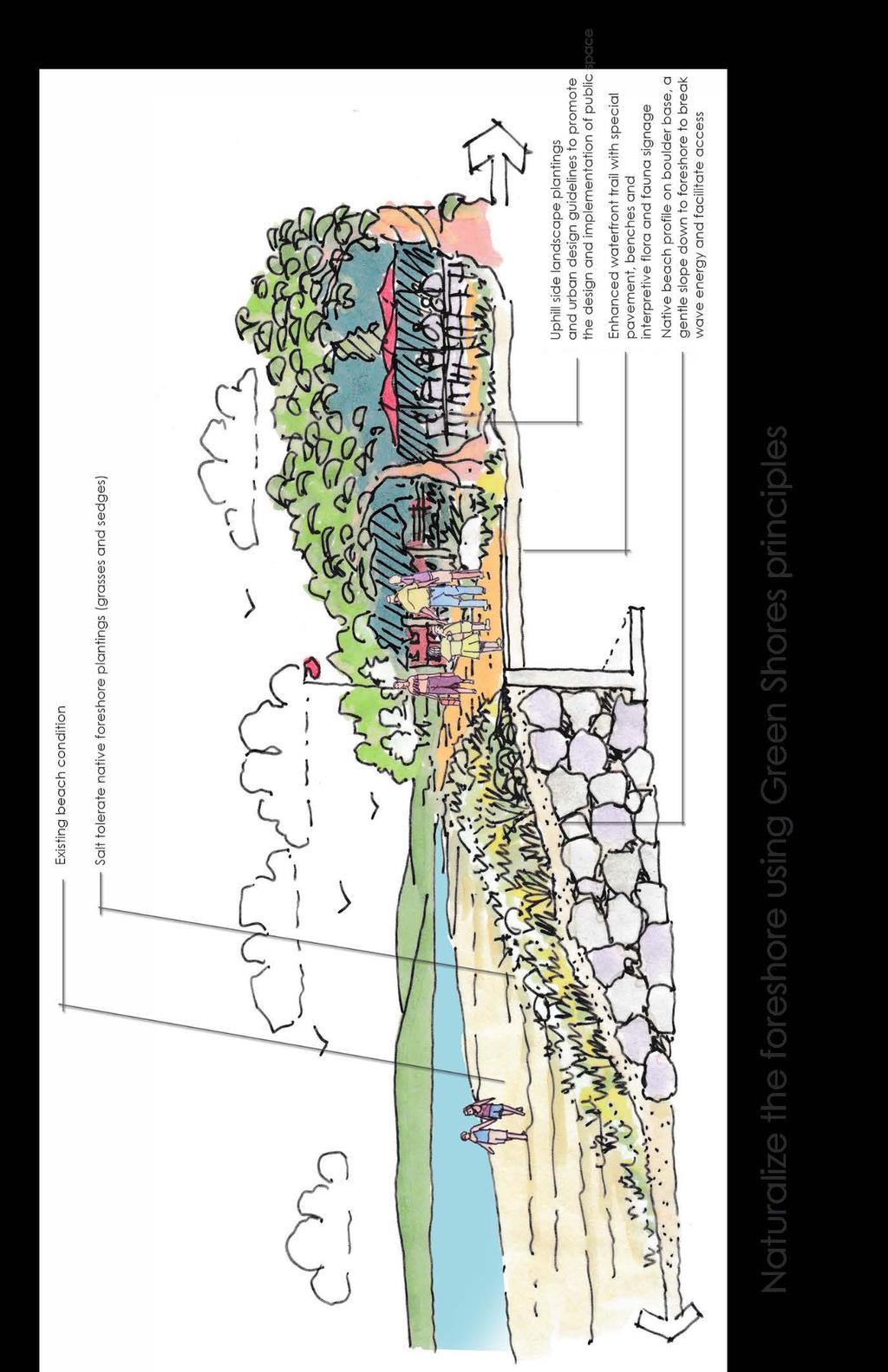
5 1.0: A Naturalized Foreshore and Shoreline Protection Vision A healthy marine ecosystem that is not threatened by human interference, as well as a naturalized foreshore that uses coastal processes to protect upland amenities The Qualicum Beach waterfront has been significantly hardened over the last 60 years, with an increasing number of hard seawalls, rock revetments, rip-rap walls and other types of foreshore protection. Research in the first phase of the Waterfront Master Plan shows that hard foreshore protection has negatively impacted foreshore ecosystems and resulted in the erosion of fine sands from the upper intertidal beach area. This has degraded the charm of the beach, and the health of the marine environment. Restoring a natural beach profile and recovering from the damages inflicted by hard protection over the last 60 years is a long-term project. This will require site-specific interventions, as well as knowledge and understanding of the overall coastal processes. Goals 1. Establish a varied, natural beach profile. 2. Enhance the habitat and ecosystems of the waterfront. 3. Discourage additional foreshore hardening. Policies Goal: Establish a varied, natural beach profile to protect against future damage. a) Maintain and restore a natural beach profile upland from the 2016 natural boundary where possible. b) Where it is not feasible to restore a natural beach profile upland of the 2016 natural boundary, foreshore protection that includes a natural beach profile outside of the current natural boundary should be considered instead of a hard wall at the property line. c) Prohibit hard foreshore protection outside of the current natural boundary. d) Encourage groups of private property owners to work together on shoreline adaptation. e) Assist private property owners with adaptation through coordination, advocacy and planning. Goal: Enhance the habitat and ecosystems of the waterfront. a) Restore the conditions for a thriving marine ecosystem. b) Facilitate fish access from the ocean to local watercourses. c) Restore natural sediment transfer processes and watercourses where possible. d) Design storm water systems to protect and enhance the waterfront. e) Explore off-shore structures to protect and enhance the shoreline ecosystem and break wave energy. f) Undertake restoration of the shoreline ecosystem. g) Plant more vegetation (e.g. eelgrass, trees). h) Establish a natural beach profile, which may or may not incorporate existing walls. 5
6 6
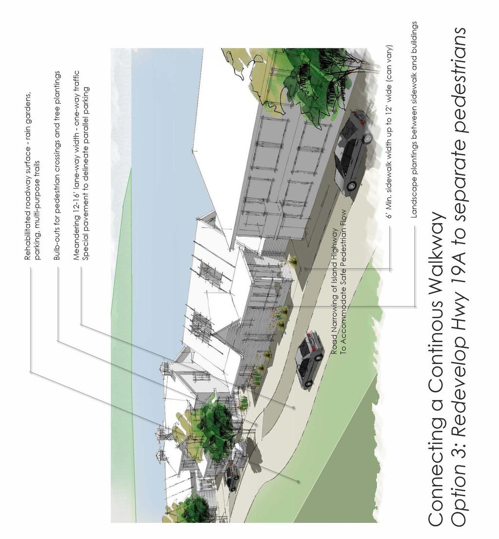
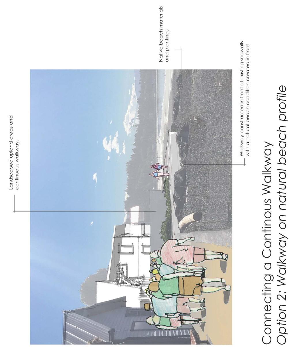
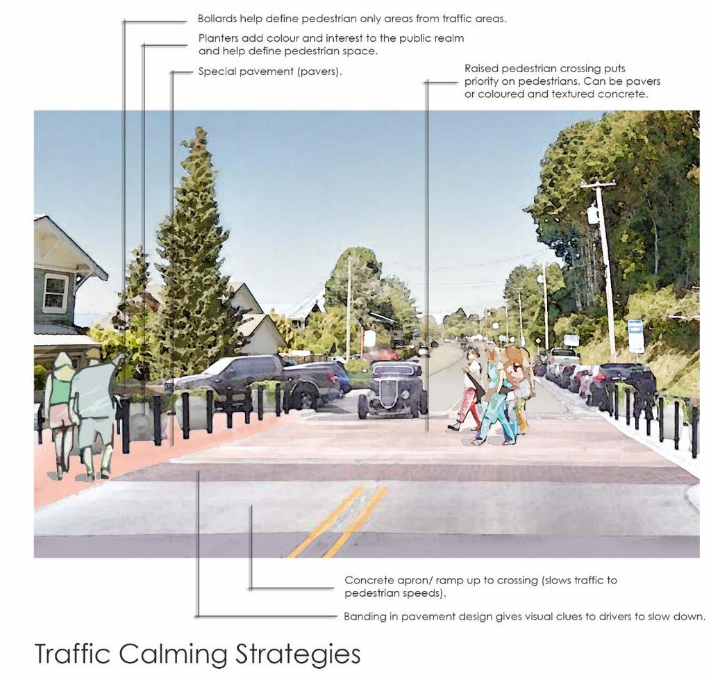
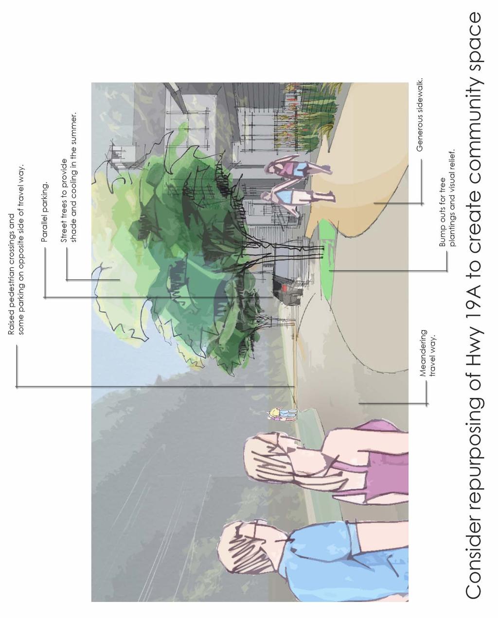
7 2.0: Access Vision A foreshore and upland area that is accessible in a number of different ways, while respecting and avoiding interference with marine ecosystems. The marine foreshore is a fragile interface between the ocean and land, and between the human and natural environments. The upland area of the waterfront is primarily dominated by human activity, including roads, buildings, infrastructure, etc. Some of investments at the foreshore interface have inadvertently created a divide between the foreshore and the upland area. For example, the hard seawalls create a barrier that many people cannot easily navigate, and the stairs connecting the walkway to the beach require regular maintenance. Residents and visitors to Qualicum Beach value safe and convenient access to the waterfront. For some, accessing the waterfront means enjoying the view from a bench or vehicle. For others, access means walking on the beach or engaging in activities. While retaining a focus on shoreline protection and the preservation of natural ecosystems, efforts should be made to strengthen the connection between the upland and foreshore. Goals 1. Develop a safe, continuous walkway. 2. Reduce automobile traffic along the waterfront. 3. Enhance amenities to make the waterfront more user-friendly. Policies Goal: Develop a safe, continuous walkway for all ages and abilities. a) Explore the viability of the following scenarios to implement a continuous waterfront walkway: a. A walkway along the foreshore. b. An elevated walkway on piles, groynes or other appropriate structures. c. Redevelopment of Highway 19A to build a separated lane for pedestrians/cyclists along the roadway to connect the existing, protected walkway segments. b) Where possible, buy private properties and a. Extend walkways and parkland; and/or b. Add access points to the foreshore. Goal: Reduce and control vehicular traffic along the waterfront. a) Increase use of the ring road for through traffic. b) Consider changes to Highway 19A, such as closing a portion of the road to through traffic or reducing it to a one-way road. c) Provide a shuttle bus from the downtown core to the waterfront. d) Locate centralized parking areas outside of the central waterfront. e) Consider the strategic importance of a continuous route for vehicular traffic. Goal: Make the waterfront more user-friendly. a) Add garbage cans and recycling bins. b) Build additional washrooms and change rooms. c) Add water fountains and outdoor showers. d) Provide electrical outlets to support community events. e) Improve beach access points for all abilities. f) Support a range of tourist accommodation. g) Encourage mooring buoys or other methods to encourage boaters to explore the Town. 7
8 8
9 9
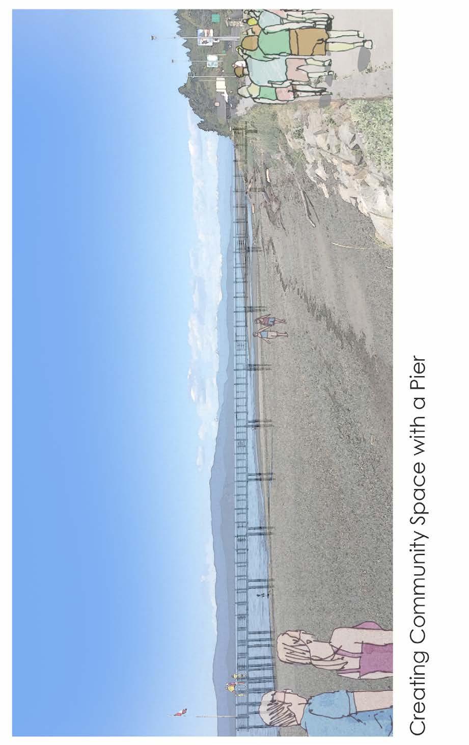
10 3.0: Community Gathering Places Vision A network of community gathering places that support a wide range of informal and formal uses, as well as group sizes. The waterfront is a formal and informal gathering place for both residents and visitors. The waterfront brings people together to celebrate, relax, learn and engage with nature. Many people enjoy the natural features, such as the beautiful view, sandy beach, trees, and rocks or logs to sit on. The addition of grass and park space on the waterfront s upland area provides casual space for picnicking, exercise groups and relaxation. However, there are still opportunities to make minor improvements and create more community gathering spaces for small groups who come to the waterfront to be together. Along the waterfront, large groups have the ability to gather along the beach at low tide, while smaller groups take advantage of the picnic and grassy areas. However, the waterfront is not currently suited for groups that require seating, a small stage, chalkboard or other amenities. One of the major opportunities to increase public space is to restore public use of land along the waterfront. A preliminary review of encroachments into the waterfront upland and foreshore area shows many cases where public land is being used for private parking, yard space, patios and even houses. In an area where usable land is scarce and public interest is high, the Town should find ways to discontinue encroachments onto public land. Goals 1. Create opportunities to bring people together in groups of all sizes, using natural amenities wherever possible. Policies Goal: Increase opportunities for groups of all sizes to gather a) Develop a gathering area for outdoor learning and small performances. b) Acquire more waterfront property to use as community space where possible. c) Restore the public use of land where private property owners have encroached onto Town-owned land, the road right of way or the foreshore area. d) Explore creative financing mechanisms to acquire private properties along the waterfront. e) Incorporate more picnic tables, fire pits, and barbeques. f) Consider a pier or dock that extends into the water. g) Consider periodic or temporary repurposing of Highway 19A to support events and community gathering. 10
11 11
12 12
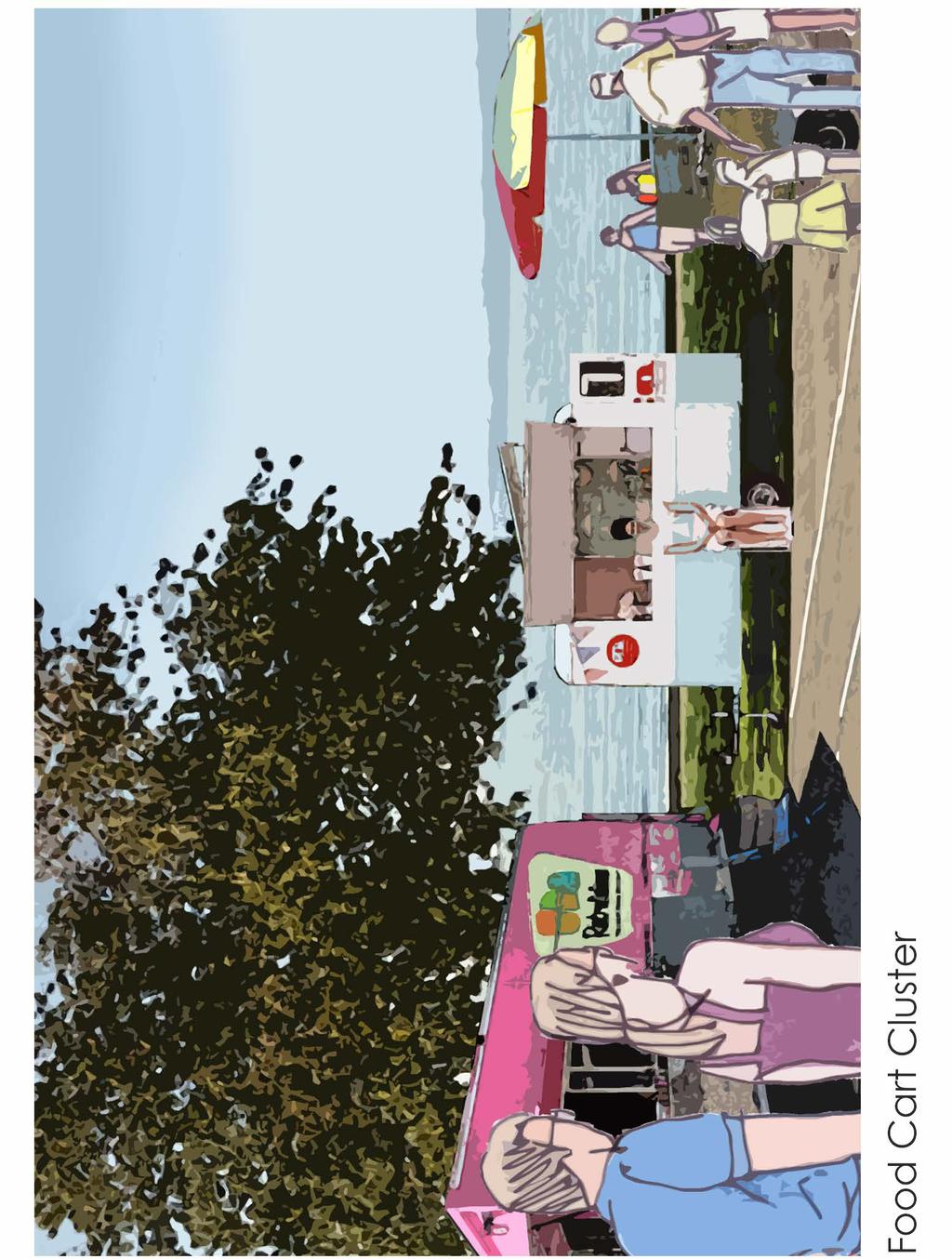
13 4.0: Economic Opportunities on the Waterfront Vision A prosperous economy that co-exists with natural ecosystems and provides opportunities for residents and visitors to enjoy the waterfront. The foreshore has always been a source of prosperity for people in the Qualicum Beach area. Currently, economic activity along the waterfront is primarily oriented towards tourism, food and entertainment. Economic activity along the waterfront and Highway 19A has lessened from its peak in the mid-20th century, and the number of units available in hotels and motels has decreased significantly. Economic activities that align with the principles in this plan should be supported, and the waterfront area should be more strongly connected to the downtown. Visitors to the downtown should be encouraged to enjoy the beach, and visitors along the waterfront should be encouraged to visit the downtown for a wider range of amenities. The commercial heart of Qualicum Beach is, and will continue to be, downtown. Goals 1. Sustain and be open to opportunities for commercial activities that support the goals of the plan. 2. Expand food options along the waterfront. 3. Increase tourist accommodation. 4. Connect the downtown to the waterfront. Policies Goal: Expand food options along the waterfront a) Determine a location where food trucks are permitted, either on Town-owned or private land. b) Encourage the development of restaurants and coffee shops. Goal: Increase tourist accommodation along the waterfront a) Convert select parking spaces or add additional parking to permit some overnight RV parking. b) Recognize and support the value of hotels and motels. c) Prevent conversion of tourist accommodation to residential use. d) Encourage the development of vacation rentals on private property. Goal: Create appropriate commercial opportunities along the central waterfront a) Accommodate temporary, pop-up commercial and rental kiosks for beach amenities that support the overall vision for the waterfront, such as artwork, nonmotorized recreational equipment (e.g. kayaks, paddleboards, canoes) and guided tours. b) Where possible, encourage development on the south side of Highway 19A rather than the waterfront side. Goal: Connect the downtown to the waterfront a) Improve existing connections that support a variety of transportation alternatives. 13
14 14


 Provide educational signage on the environmental, cultural and geological history of the waterfront.")
15 5.0: Cultural Awareness and History Vision A vibrant upland area that exhibits the cultural pride and history of Qualicum Beach. There are many opportunities to incorporate cultural education and awareness into the development of the waterfront. Natural beauty surrounds Qualicum Beach, and the rich cultural history should be shared with those who live in and visit the area. Opportunities to share this history include public art, interpretive signage and personal guides to help people appreciate the rich cultural, ecological and artistic heritage of the Town. Goal 1. Exhibit cultural awareness and history. Policies a) Provide educational signage on the environmental, cultural and geological history of the waterfront. b) Review and update existing information displays to incorporate cultural and historical references where appropriate. c) Provide opportunities for First Nations to display their history and artwork. d) Work with First Nations to recognize and exhibit traditional activities in Qualicum Beach. 15


16 6.0: Community Activities on the Waterfront Vision A wide range of activities that co-exist with marine ecosystems and respect the natural ambience of the waterfront. From high-intensity sports like kite boarding and skim boarding to passive activities such as reading books and observing wildlife, the waterfront is home to a wide range of recreational opportunities. Most of these activities do not require improvements since they rely on natural amenities, such as the sandy beach and ocean. However, it is important to acknowledge the importance of community activities along the waterfront when making decisions in the future. This plan supports those activities that do not negatively impact the natural ecosystems and tranquil ambience of the waterfront. Motorized activities, such as jet skis, are not encouraged. Goals 1. Continued access to a wide range of activities for both residents and visitors. Policies Goal: A wide range of recreation opportunities a) Consider the impact on recreational opportunities prior to making decisions. b) Support activities that do not negatively impact the natural ecosystems and tranquil ambience of the waterfront. c) Build wildlife observation platforms and other places to enjoy nature. d) Improve information signage. e) Ensure that there is adequate seating for people to sit and enjoy the waterfront. Goal: Incorporate recreational space along the waterfront a) Improve access to the foreshore. b) Facilitate cooperation among all recreational users through education. c) Build a gathering space for outdoor learning and small events. 16
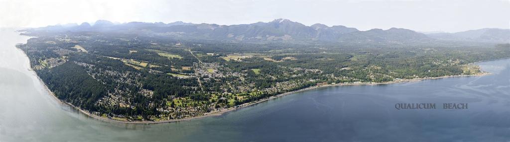
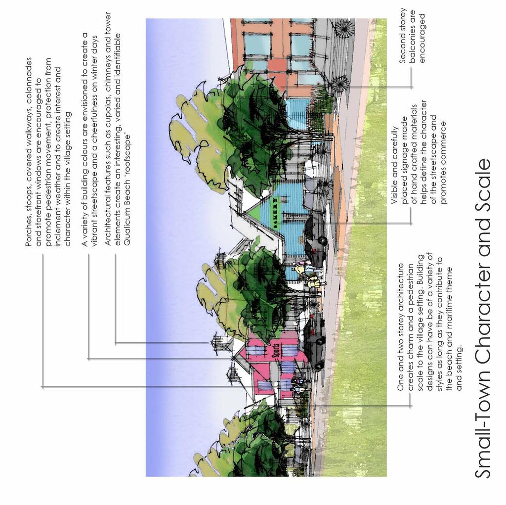
17 7.0: Viewscapes and Small-town Character Vision Appropriate developments that respect the history and identity of the waterfront, with a priority on maintaining views from public areas. The waterfront boasts a panoramic view of Lasqueti, Texada, Denman and Hornby Islands, the snow-capped mountains of the mainland, and the expansive foreshore. At low tide or from a boat, the view inland is also remarkable, with Mount Cokely and Mount Arrowsmith looking down over the lands below, testament to the geological history of the area that once saw the base of these mountains under thousands of feet of ice. The view of the waterfront is precious and should be considered in all aspects of waterfront development. There may be opportunities to improve views through cooperation with owners and developers. Views are a public asset that should not be privatized without careful consideration. The character of the waterfront has its roots in the informal cabins and small seasonal accommodations that popped up above the high tide line early in the 20 th century. Buildings are generally low in height and small in scale, with a humble style that speaks to gradual improvement and informal development. Goals 1. Maintain a strong visual connection between the waterfront and upland area. 2. Maintain small-town character. 3. Enhance the park-like setting along the Central Waterfront Policies Goal: Maintain public safety along the waterfront a) Review the safety and functionality of the existing walls. b) Consider low-level lighting for the purpose of safety. Goal: Protect the small-town character and viewscapes of the waterfront a) Manage the height and massing of redevelopment on the water side of 19A to maintain and/or enhance views. b) When development occurs, require that designs be compatible with the small-town character and history of the waterfront. 17
18 18
19 Next Steps Looking towards the next century, the waterfront will be transformed by rising sea levels and continued human intervention. Waterfront properties will either be protected by a heavy investment in shoreline protection, designed to accommodate regular flooding, or be left to erode. Although the results described in [the] report are mainly related to the arrival of one metre of sea level rise (likely before 2100) the flooding hazard described in [the] report will start to become an issue before then. A plan and likely staged response to deal with the increasing hazard should be developed. (Qualicum Beach Waterfront Master Plan - Phase 1 Coastal Processes and Assessment Report, Page 9) In the long-term, it is expected that sea levels will continue to rise in excess of 1.0m, ultimately reaching a level much higher than the current water level. The next five years ( ) are expected to reveal more about the rate of sea level rise and the anticipated effects on coastal communities, and the Town of Qualicum Beach may have to shift course. In the meantime, there is valuable work to advance community objectives while preparing for a wide range of scenarios. Following are some of the implementation measures that warrant an investment of time and resources in the short-term. 1. Monitor erosion and coastal conditions with annual topography and airphotos. 2. Prepare shovel-ready pilot projects to test scenarios for coastal protection. 3. Work with property owners to establish neighbourhood level adaptation strategies. 4. Work with authorities to establish a streamlined approvals process for projects in Qualicum Beach that are consistent with the Waterfront Master Plan. 5. Develop a safe, continuous waterfront walkway from the Visitor Centre area to the beach washrooms 6. After monitoring the results of the continuous walkway west of the Visitor Centre, explore options to extend a continuous waterfront walkway past the residential dwellings west of Bay Street. 7. Update the Waterfront Master Plan in conjunction with future Official Community Plan reviews. 19
20 References Additional information and supporting documentation that was developed as a part of the Qualicum Beach Waterfront Master Plan process is available on the Town of Qualicum Beach website and in hard copy at the Qualicum Beach Town Hall. The content of this Plan is based on the input received by stakeholder groups, including community members, students, and visitors, as detailed in the Qualicum Beach Waterfront Master Plan Consultation Report SNC Lavalin, (2015) Coastal Processes and Assessment Report SNC Lavalin, (2015) Appendix A Hydrodynamic Model SNC Lavalin, (2015) Appendix B Wind Model SNC Lavalin, (2015) Appendix C Wave Model SNC Lavalin, (2015) Appendix D Coastal Processes Model SNC Lavalin, (2015) Appendix E Existing Shoreline Condition SNC Lavalin, (2015) Appendix F Conceptual Solutions 20

21 Infrastructure Engineering Ports and Marine Appendix A SNC-Lavalin Inc. Suite Thurlow Street Vancouver, BC, Canada, V6E 0C TECHNICAL MEMO TO: Luke Sales DATE: May 17, 2016 C.C.: John Readshaw, Cliff Robinson FROM: Jessica Wilson PROJECT: Qualicum Beach MSA Call-Up 4 MEMO NO: 0001 SUBJECT: 1. INTRODUCTION Engineering and Environmental Framework to Evaluate Waterfront Development Concepts DOCUMENT NO: PEN-0001 The Town of Qualicum Beach is developing a comprehensive Waterfront Master Plan that will help the town achieve the long-term goal of environmental, economic, social, and cultural sustainability. The Town has now started Phase 2 of the planning process. This phase includes a broad consultative process for the final development of the Waterfront Master Plan, which involves the identification of overall community values for the waterfront area. As a result of Phase 2, it is anticipated that several waterfront development concepts will start to emerge that reflect the values being identified. This memo outlines the development of an engineering and environmental evaluation framework to evaluate waterfront concepts that evolve as a result of this public consultation process. This framework is intended to be used in conjunction with the Community Values Evaluation framework developed by the Town of Qualicum Beach. 1.1 Glossary of Terms This memo includes terminology that is specialized to the coastal engineering and marine ecology areas of practice, but essential to preserve the integrity and accuracy of the framework. A glossary of terms and abbreviations is provided in Section 4.0 to provide clarification as necessary. 1.2 Evaluation Basis In order to develop an evaluation framework, a review of existing principles, frameworks, and strategies was undertaken. Several references, including Green Shores TM, were noted to have significant applicability. These references, as well as general references, are detailed in Section 5.0 and summarized below. [1] Green Shores Coastal Development System: The Certification Process [2] Greening Shorelines to Enhance Resilience: An Evaluation of Approaches for Adaptation to Sea Level Rise [3] Marine Habitat Offsetting Options Analysis: CFB Esquimalt [4] for Protection and Restoration of Nearshore Ecosystems of Puget Sound [5] Coastal Climate Resilience: Urban Waterfront Adaptive Strategies [6] plannyc: a Stronger More Resilient New York Page 1 of 18
22 Qualicum Beach Call-Up 4: Engineering and Environmental Evaluation Framework Technical Memo PEN ENGINEERING AND ENVIRONMENTAL EVALUATION FRAMEWORK 2.1 Framework Criteria The engineering and environmental evaluation framework was developed using the following general principles: 1) Compatibility with the expected coastal/marine conditions, 2) Maintain or enhance foreshore ecological services, and 3) Optimize community investment in waterfront areas. For the purpose of defining the evaluation framework, 11 criteria were selected to evaluate and compare proposed coastal development options and linked to the three general principles. The framework criteria, precedence, and weighting are described in Table 1. In this framework, the Option refers to the proposed concepts, alternatives, or options that emerge from Phase 2 of the public consultation process. 2.2 for Use Prior to the use of this framework, Options should be defined in sufficient detail to understand design and construction constraints, hydrodynamic and morphological processes, and potential coastal ecological effects; however, it is intended that the evaluation matrix can and should be used to assist in the screening or ranking of multiple options in the early stage of a planning process. In this case, when only very conceptual engineering or environmental work has been completed, the evaluation process should be undertaken by knowledgeable practitioners familiar with the involved disciplines, the site, and the planning process objectives. This Engineering and Environmental Evaluation framework should be assessed independently from the Community Values Evaluation framework. Options should be evaluated by several (e.g. two or more) independent professionals, with a strong knowledge of coastal engineering or coastal marine ecological processes. Individual criteria may be rated differently or subjectively by qualified independent engineering or environmental professionals; however, the ensemble of scores should give a reasonably informative and relative determination of the general engineering and ecological merits of each Option. Detailed guidance for evaluating individual framework criteria is included in Section 2.3. Two conceptual pilot case studies applying the framework are included in Section 3.0. The final results from both frameworks should be reviewed in tandem to obtain a general understanding of the overall potential implications of an Option. Page 2 of 18
23 Qualicum Beach Call-Up 4: Engineering and Environmental Evaluation Framework Technical Memo PEN-0001 Table 1: Framework Criteria Descriptions No. Criteria Name Description Basis Weight (%) Principle 1: Compatibility with the Expected Coastal/Marine Conditions 1a Compatibility with Expected Sea Level Rise Can the Option be modified or raised to meet revisions or updates to the expected sea level rise during the life of the structure? General Criteria 1 [2] HOC 8 [3] 10 1b Flood Adaptation Effectiveness Does the Option provide effective flood protection from the combined effects of tides, surge, and waves? General Criteria 2 [2] 12 1c Compatibility with Coastal Processes Does the Option disrupt physical coastal processes, such as alongshore or cross-shore transport? Objective 1 [1] Prerequisite 4 [1] ES 1 and 7 [2] 12 Sub-Total 34 Principle 2: Maintain or Enhance Foreshore Ecological Services 2a Effect on Marine Riparian Vegetation Does the Option enhance or reduce the marine riparian vegetation zone? Objective 2 [1] Prerequisite 2 and 3 [1] ES 2, 3, and 4 [2] Criteria 6 [4] 8 2b Foreshore Habitat Supply Does the Option enhance or reduce naturally occurring foreshore habitat? Objective 2 [1] ES 5 [2] HOC 1 to 4 [3] Criteria 6 [4] 8 2c Foreshore Habitat Diversity Does the Option enhance or reduce foreshore habitat diversity? Objective 2 [1] ES 6 [2] HOC 1 to 4 [3] 8 2d Marine Pollutants Does the Option reduce or contribute pollutants to the marine environment over the life of the Option, including during construction? Objective 3 [1] 5 2e Cumulative Effects to the Foreshore Environment Does the Option reduce or increase the cumulative effects on the Qualicum Beach foreshore environment during the life cycle of the structure? Objective 4 [1] 5 Sub-Total 34 Principle 3: Optimize Community Investment 3a 3b 3c Compatibility with Existing Infrastructure and Adjacent Properties Stability and Maintenance Technical Feasibility and Innovation Does the Option require the removal or relocation of existing infrastructure, such as roads or houses, or does the Option affect adjacent properties or the foreshore environment? How structurally stable is the Option in response to external factors, such as extreme weather events? Will the Option require frequent or extensive maintenance? Is the Option technically feasibility and likely to have a successful outcome, considering the complexity, design issues, and precedence of the project? Prerequisite 1 [1] Consistency with adjacent land use [6] 11 HOC 6 [3] 10 HOC 5 and 7 [3] Criteria 4 and 8 [4] 11 Sub-Total 32 Total 100 Page 3 of 18
24 Qualicum Beach Call-Up 4: Engineering and Environmental Evaluation Framework Technical Memo PEN Criteria Descriptions for evaluating the Options using the above criteria is provided in the following sub-sections. The Option under evaluation is given a score of +2, +1, 0, -1, or -2 for each criterion, based on the described guidance Principle 1: Compatibilty with the Expected Coastal/Marine Conditions Criteria 1a Compatibility with Expected Sea Level Rise Objective: To promote resilience to the impacts of sea level rise and adaptability to revisions or updates to the expected sea level rise. Evaluation : The 2011 Provincial Guidelines recommend considering 1m of sea level rise by the year 2100, or 10mm/year [7]. Recent literature and data suggest that the rate of SLR may be much faster than previously expected, however there are still large uncertainties within scientific estimates. It is important that the Option is resilient to SLR and compatible with adjustments or revisions to the expected rate of SLR over the life of the structure. For example, earth dikes can be easily expanded in phases to increase the width and height in accordance with SLR revisions. Conversely, seawalls are difficult to alter after initial construction without structural implications, and may not be compatible with adjustments to the expected sea level rise. Table 2: for Criteria 1a s The Option is designed for up to 20mm/year of SLR over the life of the structure. The Option would require replacement of less than 50% of the existing structure to increase compatibility with changes to the expected SLR. The Option is designed for up to 20mm/year of SLR over the life of the structure. The Option would require replacement of more than 50% of the existing structure to increase compatibility with changes to the expected SLR. The Option is designed for up to 10mm/year of SLR over the life of the structure, consistent with 1m of SLR by year 2100 [7]. The Option would require replacement of less than 50% of the existing structure to increase compatibility with changes to the expected SLR. The Option is designed for up to 10mm/year of SLR over the life of the structure. The Option would require replacement of more than 50% of the existing structure to increase compatibility with changes to the expected SLR. The Option is not designed for 10mm/year of SLR over the life of the structure and would require replacement of the entire structure to increase compatibility. Criteria 1b Flood Adaptation Effectiveness Objective: To prevent damage to persons, property, or infrastructure as a result of flooding, and promote neighborhood scale protection measures. Evaluation : Flood protection is one of the primary functions of coastal structures as the result of the combination of SLR, storm surge, tides, and wave effects. Climate change may result in an increase of wave energy at the shoreline through increased water levels and stronger, more frequent storms. When evaluating the flood protection effectiveness, it is important to consider how coastal structures interact with these components and ensure resilience to changes in the marine environment. For example, hard engineering solutions 1 typically act to reflect waves and create large quantities of spray and overtopping, which leads to flooding. Conversely, soft engineering solutions 2 typically act to absorb wave energy by forcing waves to break before they reach the shoreline, thereby reducing overtopping and flooding. 1 Hard engineering solutions: These approaches include, in general terms: seawalls or revetments, including vertical seawalls, bulkhead systems, rock armour revetments, and conventional sea diking systems. 2 Soft engineering solutions: These approaches include, in general terms: beach nourishment, restoration, or construction, dune and wetland construction, shore vegetation preservation or restoration, and nearshore reef and berm construction. Page 4 of 18
25 Qualicum Beach Call-Up 4: Engineering and Environmental Evaluation Framework Technical Memo PEN-0001 Additionally, Options that provide flood protection on a large, neighbourhood or regional scale provide protection from both direct 3 and indirect 4 flooding of properties. Options that provide site-specific flood protection typically remain exposed to indirect flooding from adjacent waterfront properties and provide little to no direct protection to the adjacent properties. For these reasons, the scale of a protection measure is crucial to its flood protection effectiveness. For example, wetland restoration has been recognized as a potentially useful way to provide efficient regional flood protection through wave dissipation and provide many ecological benefits [10]. This Option would likely score favourably for this criterion Table 3: for Criteria 1b s The Option uses primarily soft engineering solutions to provide flood protection on the scale of the neighborhood. The Option uses primarily hard engineering solutions to provide flood protection on the scale of the neighborhood. 0 The Option results in site-specific flood protection using primarily soft engineering solutions. -1 The Option results in site-specific flood protection using primarily hard engineering solutions. -2 In light of the site s history, the Option reduces or does not provide flood protection. Criteria 1c Compatibility with Coastal Processes Objective: To maintain natural cross-shore and alongshore coastal processes that transport and move organic and inorganic, natural materials and provide important connectivity services. Evaluation : Coastal processes, such as along shore currents, drive the movement of organic and inorganic material on the nearshore. For example, cross-shore processes transport important nutrients and organic materials between the foreshore and the marine riparian zone. The placement of hard structures along the shoreline inhibits cross-shore transport and tends to result in slow erosion/depletion of the foreshore. Hard structures, such as groins, tend to inhibit long-shore transport, which can induce sedimentation on the up-current side of the groin and result in beach depletion down-current. Table 4: for Criteria 1c s The Option results in no hard structures along the shoreline, only natural shoreline and soft structures. The Option results in greater than 50% of the shoreline with natural shoreline and soft structures. Any hard structures, including berms, are not likely to modify alongshore or cross-shore processes. In light of the site history, the Option does not result in changes to the shoreline or modify alongshore and/or cross-shore processes. The Option results in the placement of hard structures, including groins, along more than 50% of the shoreline. Hard structures likely modify alongshore and/or cross-shore processes. The Option results in hard structures along the entire shoreline length and likely modify cross-shore and/or alongshore processes. 3 Direct flooding: Flooding by means of the direct inundation or overtopping of the properties shoreline. 4 Indirect flooding: Flooding by means of inundation or overtopping of the adjacent properties shoreline and spill-over effects indirectly flooding the property under consideration. Page 5 of 18
26 Qualicum Beach Call-Up 4: Engineering and Environmental Evaluation Framework Technical Memo PEN Principle 2: Maintain or Enhance Foreshore Ecological Services Criteria 2a Effect on Marine Riparian Vegetation Objective: To maintain or enhance the presence of vegetation in a marine riparian zone at the edge of the foreshore. Evaluation : Marine riparian vegetation (MRV) is recognized as a dynamic ecozone extending landward from the high water level of shorelines. The MRV zone is usually defined as a strip along the land-water interface at the higher high water large tide or high water mark (natural boundary). In practice, this zone is usually best determined in the field from the spatial extent of vegetation and driftwood. To preserve this habitat zone, there is a requirement for a marine riparian buffer 5m wide, at minimum. MRV includes numerous species of grasses, sedges, shrubs, herbs, and trees. The transition area between the upland and foreshore provides many ecological services which ultimately contribute to the stability and resilience of foreshore ecosystems: Provide pathways for the movement of nutrients between the foreshore and upland. Provide pathways of nutrients from freshwater flowing from the upland to the foreshore. Vegetation acts to filter upland surface run-off flowing into the foreshore, enhancing water quality. Provides wildlife habitat and nutrient and leaf litter input, enhancing feeding conditions for small fish in the upper foreshore such as young salmon. Marine riparian vegetation has a direct influence on the egg incubation success via shading for foraging fish species such as surf smelt and Pacific sand lance. Vegetation improves soil stability and sediment control and reduces erosion into the foreshore. For example, a sandy beach Option may be enhanced by a MRV zone of dune grass and/or shore pine, which are known to stabilize shifting sand Table 5: for Criteria 2a s The Option restores or enhances the naturally occurring MRV zone along the entire project shoreline. The Option restores or enhances at least 50% of the linear (m) or surface area (m 2 ) of naturally occurring MRV zone. 0 In light of the site s history, the Option does not reduce or enhance the MRV zone The Option eliminates or reduces at least 50% of the linear (m) or surface area (m 2 ) of naturally occurring MRV zone. The Option eliminates or reduces the naturally occurring MRV zone along the entire project shoreline. Criteria 2b Foreshore Habitat Supply Objective: To maintain of enhance the existing naturally occurring foreshore habitats. Evaluation : Foreshore habitats present at a site, such as eelgrass, adapt to the local hydrodynamic conditions, namely exposure to waves, currents, and/or river flow. The alteration of existing foreshore habitats may ultimately change the productive capacity and ecological resilience of the shoreline. For example, vertical engineered structures, such as seawalls, replace naturally sloping shorelines and eliminate gradual changes in upper foreshore water depth, reducing the habitat function and the flood storage capacity. Some of the key functions of foreshore habitat include: The intrinsic capacity of foreshore habitat to produce primary and secondary prey (e.g. micro-, meso-, and macro-benthos) for consumption by tertiary predators such as fish, birds, and mammals. The physical structure of habitats plays a key role in the nursery function for fish and invertebrates (e.g. young salmon, Dungeness crabs). The combination of habitat structure, increased water temperatures, and enhanced foraging opportunities on the foreshore provide the vital conditions for the survival and growth of fish and invertebrates. Page 6 of 18
27 Qualicum Beach Call-Up 4: Engineering and Environmental Evaluation Framework Technical Memo PEN-0001 Several foreshore habitats, such as eelgrass meadows, have been frequently identified as contributing disproportionately to the ecological resilience of the foreshore through their wave-dampening properties, sediment stabilizing capability, and nursery functions for young fish and invertebrates. Accumulation of decaying eelgrass in the high intertidal, as part of beach wrack, may also provide enhanced wave-dampening properties. Particular emphasis should be placed on maintaining or enhancing eelgrass where possible. Table 6: for Criteria 2b s The Option restores or enhances naturally occurring foreshore habitat along the entire project shoreline (e.g. gravel beach). The Option restores or enhances at least 50% of the linear (m) or surface area (m 2 ) of naturally occurring foreshore habitats. The Option does not reduce or enhance the linear (m) or surface area (m 2 ) of naturally occurring foreshore habitats. The Option reduces at least 50% of the linear (m) or surface area (m 2 ) of naturally occurring foreshore habitat. The Option reduces or eliminates naturally occurring foreshore habitat along the entire project shoreline. Criteria 2c Foreshore Habitat Diversity Objective: To maintain or enhance the diversity of foreshore habitats at the site. Evaluation : The diversity of foreshore habitats at a site directly contributes to increased species diversity. Ecological resilience of the foreshore is extremely sensitive to the removal of any habitat and its associated species because of food web ramifications. For example, hard engineering approaches, such as shoreline armouring, can negatively effect foreshore habitat diversity by reducing the amount of intertidal habitat, reducing production of prey, and increasing water temperatures. However, design modifications, such as adding habitat benches within rip-rap revetments have achieved the goal of maintaining or increasing site habitat diversity. Other approaches have been used to modify shoreline armouring to enhance habitat diversity, including selecting certain types of porous rock to improve water retention on low tides and ultimately algal and macro faunal colonization. For example, concrete blocks with a textured surface were found to be more rapidly colonized by small green algae than those slabs with a smoother surface. Geometric structures within the slabs (e.g. cups and holes) retained water longer during low tide and favoured the initial colonization by larger green algae. Small adaptations of both texture and structure of concrete constructions within the intertidal zone led to better settlement, colonization, and increased diversity of algae and macro benthos. Ultimately the creation of macro or micro habitats at a site through careful design will act to enhance habitat diversity and ultimately maintain ecological services Table 7: for Criteria 2c s The Option increases foreshore habitat diversity by at least two habitat types along the shoreline associated with the proposed activity. The Option increases foreshore habitat diversity by at least one habitat type along the shoreline (e.g. habitat benches along the toe of a rip-rap revetment). 0 The Option does not reduce or enhance foreshore habitat diversity The Option results in the direct burial, removal or permanent alteration of at least one type of existing foreshore habitat. The Option results in the direct burial, removal, or permanent alteration of at least two types of existing foreshore habitats. Page 7 of 18
28 Qualicum Beach Call-Up 4: Engineering and Environmental Evaluation Framework Technical Memo PEN-0001 Criteria 2d Marine Pollutants Objective: To remove, reduce, or remediate pollutants entering the marine environment. Evaluation : Marine pollutants are substances or materials (e.g., fine sediments) that enter the marine environment that can have negative effects on plants, animals, or humans. The addition of pollutants into sensitive coastal areas such as the marine riparian zone can have disproportionately large effects on vegetation and upper foreshore forage fish species such as surf smelt and Pacific sand lance. Pollutants can include oil spills, plastics, pesticides, fertilizers, and overland runoff, for example and may enter the marine environment from several sources including overland run-off, offshore sources, river or creek input, or human activity on the foreshore. Of particular note, the OCP [12] refers to the existence of pollutants entering Grandon Creek and Beach Creek which could enter the marine environment Table 8: for Criteria 2d s The Option removes, reduces, or remediates all sources of marine pollutants along the entire project shoreline. The Option removes, reduces, or remediates marine pollutants along at least 50% of the project shoreline (e.g. overland run-off). In light of the sites history, the Option does not change the exposure of the marine environment to pollutants. The Option increases or contributes marine pollutants along at least 50% of the project shoreline (e.g. oil contamination). -2 The Option increases or contributes marine pollutants along the entire project shoreline. Criteria 2e Cumulative Effects to the Foreshore Environment Objective: To reduce the cumulative effects of waterfront developments on the foreshore. Evaluation : Cumulative effects assessments (CEA) consider the combined effects of past, current, and reasonably foreseeable future activities on the foreshore environment [11]. They should assess the effects on important ecosystem components, such as eelgrass, due to interactions with other activities. CEAs are expected to consider the scale of effects, both temporal and spatial, the type and number of effects, and the magnitude of effects. In practice, the CEAs are difficult and complicated to complete. In order to simplify the assessment of cumulative effects, this evaluation criterion will primarily consider the potential spatial scale of effects. For this assessment, the regional and local scales can be defined as follows: Regional scale: Includes the shoreline within either the entire Qualicum Beach jurisdiction or twice the length or footprint of the Option on either side of the Option, whichever is larger. Local scale: Includes either the two adjacent shoreline neighbours or one times the length or footprint of the Option shoreline on either side of the Option, whichever is larger. When rating the Option, evaluators should identify the worst, or most prevalent, potential cumulative effects that occur over the life of the Option. For example, cumulative effects on beach wrack could be considered due to its importance to foreshore nutrient cycling. Hard structures may remove sources of beach wrack and tend to restrict the accumulation and movement of beach wrack between the foreshore and upland areas; combined, these processes may increase the cumulative effects on foreshore ecological processes such as food web function and productivity. Table 9: for Criteria 2e s +2 The Option reduces or removes cumulative effects to the foreshore over a regional scale. +1 The Option reduces or removes cumulative effects to the foreshore over a local scale. 0 In light of past, present, and reasonably foreseeable future activities, the Option does not likely change cumulative effects to the Qualicum Beach foreshore. -1 The Option increases or adds cumulative effects to the foreshore on a local scale. -2 The Option increases or adds cumulative effects to the foreshore on a regional scale. Page 8 of 18
29 Qualicum Beach Call-Up 4: Engineering and Environmental Evaluation Framework Technical Memo PEN Principle 3: Optimize Community Investment Criteria 3a Compatibility with Existing Infrastructure, Adjacent Properties, and Land Use Objective: To maximize the remaining value of existing infrastructure, including adjacent properties and municipal infrastructure, and to complement the viability of anticipated development or upgrades. Evaluation : This criterion considers the compatibility of an Option with existing infrastructure and adjacent properties or land use. Options that provide needed infrastructure upgrades will be more favourable. Options that negatively affect adjacent properties foreshores will be less favourable. For example, a sand beach option that provides recreational opportunities for adjacent properties and infrastructure improvements for general community use would score favourably. A dike option that required the removal or relocation of a newly constructed, high-traffic roadway or the loss of park land would not be compatible and likely score unfavourably. Similarly, a sand beach option would likely nourish the foreshore of adjacent properties, whereas a seawall may increase downstream erosion or cause increased flooding or overtopping of adjacent properties Table 10: for Criteria 3a s The Option provides both infrastructure upgrades and has beneficial effects on adjacent properties, the foreshore, and/or future land use. The Option provides infrastructure upgrades or has beneficial effects on adjacent properties, the foreshore, and/or existing land use. 0 The Option does is independent of existing infrastructure, adjacent properties, or the foreshore The Option requires the alteration or removal of existing infrastructure or has negative effects on adjacent properties, the foreshore, and/or existing land use. The Option requires both the alteration or removal of existing infrastructure and has negative effects on adjacent properties, the foreshore, and/or future land use. Criteria 3b Stability and Maintenance Objective: To ensure the stability of coastal infrastructure and reduce long-term maintenance requirements. Evaluation : The stability of an Option and the frequency and magnitude of expected maintenance are extremely important to managing cost risk and optimizing community investments and capital value. The stability and maintenance requirements of an Option are directly related to its response to extreme weather events and its sensitivity to future sea level rise. For example, structures constantly exposed to large wave forces may likely require more frequent maintenance. Additionally, hard structures may be more statically stable and require less frequent repairs than soft structures; however, repairs may have more engineering complexity and be more costly in nature. Particular consideration should therefore be made about the type of structure, its maintenance requirements, and its exposure to wave forcing. Options consistent with Green Shores [1][2] may provide more resilience to changes in the marine environment, such as sea level rise, and score favourably for this criteria. Table 11: for Criteria 3b s The Option results in a natural shoreline that requires no maintenance or modifications, and can change dynamically to adapt to the marine environment. The Option results in structures that will likely not require frequent maintenance and can be easily modified and maintained. The Option results in structures that will likely not require frequent maintenance and cannot can be easily modified and maintained. The Option results in structures that will likely require frequent maintenance and can be easily modified or maintained. The Option results in structures that will likely require frequent maintenance and cannot be easily modified or maintained. Page 9 of 18
30 Qualicum Beach Call-Up 4: Engineering and Environmental Evaluation Framework Technical Memo PEN-0001 Criteria 3c Technical Feasibiltiy and Innovation Objective: To ensure the feasibility of coastal structures and reduce risk related to design issues, complexities, and unknowns. Evaluation : Technical feasibility considers the engineering complexity, overall design issues, and innovation of the Option. Options that are more innovative, and thereby have less precedence, may provide valued services, but do not have precedence or a proven record of success, and are technically risky. Conversely, Options that use traditional, proven engineering approaches will likely have less design issues and complexities. Options that are more complex or technically challenging due to site constraints will also be more technically risky and less favourable. Special consideration should be given to Options that are considered innovative in BC or Canada, but are used reliably and have precedence elsewhere. Table 12: for Criteria 3c s The Option has no significant design issues or complexities, and uses a traditional engineering design approach. The Option has no significant design issues or complexities, and uses an innovative engineering design approach. The Option is technically feasible, has precedent, and uses a traditional engineering design approach. The Option presents some complications but is technically feasible, and uses an innovative design approach. The Option has significant design issues and complexities and is technically challenging, without precedent. Page 10 of 18

31 Qualicum Beach Call-Up 4: Engineering and Environmental Evaluation Framework Technical Memo PEN PILOT FRAMEWORK EVALUATION For the purpose of testing this evaluation framework, two existing conceptual alternatives for the central waterfront of Qualicum Beach were considered as pilot options. The considered options include: Hard alternative: Seawall Soft alternative: Sand Beach These alternatives were first considered in an evaluation study of the benefits of various shoreline treatments published in the Greening Shorelines to Enhance Resilience Report [2]. The early concepts were further evaluated during Phase 1 of the Qualicum Beach Waterfront Master Plan [13]. Modifications to the concepts were made based on the review and definition of the coastal processes along the waterfront in Phase General Background Geographic Setting and Land-Use Land-use consists of a mix of public park as well as private residential and commercial properties, along a relatively narrow waterfront strip immediately in front of high coastal bluffs, Figure 1. An important community arterial roadway exists between the waterfront property strip and the toe of the coastal bluff. A collector sewer line is also located along the shoreline, seaward of the existing seawall, and buried approximately 3 m below the beach. Metocean Setting Figure 1: Qualicum Beach Central Waterfront source: R. Guthrie, SNC Lavalin [2] The coastal processes and assessment report [13] concluded that during the predominant winter SE storms in the Strait of Georgia, the central waterfront is exposed to significantly lower wave energy than the adjacent areas. During less common, but nevertheless, frequent NW conditions in the Strait, the area is exposed to more severe wave energy at the shoreline, mainly due to the orientation of the shoreline relative to the axis of the Strait of Georgia and the direction of strong winds during these winter and summer events. The report also concluded that the central waterfront is characterized by significantly weaker tidal currents than the surrounding areas. Page 11 of 18
. The estuaries and foreshore zones of the WMA provide rearing and foraging habitat to all Pacific salmon species, Steelhead and coastal Cutthroat Trout.")

32 Qualicum Beach Call-Up 4: Engineering and Environmental Evaluation Framework Technical Memo PEN-0001 Marine Environment The Qualicum Beach central waterfront is located within a Wildlife Management area (WMA). The estuaries and foreshore zones of the WMA provide rearing and foraging habitat to all Pacific salmon species, Steelhead and coastal Cutthroat Trout. Historically, Pacific herring have spawned each spring on the abundant eelgrass and algal beds found within the WMA foreshore. In general, along the central waterfront, the upper intertidal yields significant quantities of shell hash and beach wrack throughout much of the year. The beach wrack is evidence of significant marine ecological habitat offshore in the shallow subtidal area. The wrack may also offer coastal process-related shoreline protection services during fall and winter storms. The beach wrack is an important source of organic material for beach ecosystem functioning. The ecological value of beach wrack should be considered further during the detailed definition of future shoreline modifications or improvement measures. The presence of clean medium to coarse sand in some portions of the upper intertidal beach may provide spawning habitat for important forage fish species such as Surf Smelt or Pacific Sand Lance. Modifications to the upper intertidal and shoreline area may have important implications to forage fish productivity in those areas where coarse sand is present. The lower intertidal fine sand flat shows occasional patches of an invasive eelgrass (Zostera japonica). Native (Zostera marina) eelgrass is also found in the beach wrack, which suggests this species also may exist in the area. The fine sand bench is used as habitat by various clam species as evidenced by the shell hash readily found in the upper intertidal portions of the area. Existing Shoreline The typical existing cross shore profile in the area is illustrated in the top image in Figure 2 based on a combination of LiDAR and CHS hydrographic sounding data. At normal high tides, a narrow strip of gravel beach material is present at the foot of the existing seawall, originally built in the 1960 s. A relatively flat sandy beach makes-up the remaining foreshore. Without adaption measures, a 1-m of sea level rise would likely result in flooding of the existing shoreline during a severe storm as indicated in the bottom image. Existing HHWLT Figure 2: (Top) Existing Shoreline Condition at Present High Tide (HHWLT) (Bottom) Expected Condition with 1 m SLR and Storm Surge (waves not shown) source: Greening Shorelines to Enhance Resilience [2] Page 12 of 18
33 Qualicum Beach Call-Up 4: Engineering and Environmental Evaluation Framework Technical Memo PEN Options Design Basis The design basis used for the assessment is as described in [2]. Specifically, all case examples were designed to provide a level of safety, consistent with the Provincial Guidelines [7][8][9], against flooding during a severe storm. The total water level during the considered storm is taken to be: HHWLT + 1m of SLR + expected storm surge The expected wave interaction for each case example was taken to be consistent with the expected conditions during the storm as modified by the bathymetry and shoreline structures. Hard Alternative - Seawall For the hard alternative, it was assumed that the conventional approach would be taken to raise the existing seawall in a similar fashion to the concept shown in Figure 3. The concept assumes that the elevation of the low-lying land behind the seawall would not be raised, to preserve the existing land uses and roadway. Existing HHWLT Soft Alternative Sand Beach Figure 3: Hard Alternative (Seawall) with 1 m SLR and Storm Surge (waves not shown) Adapted from: Coastal Processes and Assessment Report [13] The soft shore sand beach alternative is shown in Figure 4, which illustrates both the height of the beach fill which is located to provide safety against flooding, preserve land use by positioning the alternatives mainly over the intertidal profile, and maintain access for the public. This conceptual drawing includes an impervious dyke to prevent flooding though internal seepage. The soft alternative would likely provide important emergent vegetation habitats (eg dune grasses), foreshore eelgrass habitat, as well as upper foreshore coarse sand spawning habitat for species such as Surf Smelt or Pacific Sand Lance. Existing HHWLT Figure 4: Soft Alternative Sand Beach with 1 m SLR and Storm Surge (waves not shown) Adapted from: Greening Shorelines to Enhance Resilience [2] Page 13 of 18
34 Qualicum Beach Call-Up 4: Engineering and Environmental Evaluation Framework Technical Memo PEN Evaluation of Options The two shoreline options for the central waterfront of Qualicum Beach were evaluated using the proposed framework. Table 13 summarizes the ratings obtained for each option and the basis for the option evaluations is briefly summarized in Section 3.4. The results of this evaluation suggest that the soft alternative the sand beach is the preferable option because of its compatibility with expected coastal/marine conditions and its expected enhanced foreshore ecological services. Additionally, the soft alternative will likely optimize community investment more efficiently in comparison to the hard alternative. No. Criteria Name Table 13: Evaluation of Case Examples Hard Alternative Score Soft Alternative Principle 1: Compatibility with the Expected Coastal/Marine Conditions 1a Compatibility with Expected Sea Level Rise Weighted Score Hard Alternative Soft Alternative b Flood Adaptation Effectiveness c Compatibility with Coastal Processes Principle 2: Maintain or Enhance Foreshore Ecological Services Sub-Total a Effect on Marine Riparian Vegetation b Foreshore Habitat Supply c Foreshore Habitat Diversity d Marine Pollutants e Cumulative Effects to the Foreshore Environment Principle 3: Optimize Community Investment 3a Compatibility with Existing Infrastructure and Adjacent Properties Sub-Total b Stability and Maintenance c Technical Feasibility and Innovation Weighted score out of a possible maximum score of +200 and minimum of Sub-Total Total Page 14 of 18
35 Qualicum Beach Call-Up 4: Engineering and Environmental Evaluation Framework Technical Memo PEN Basis of Option Evaluation Criteria 1a Compatibility with Expected Sea Level Rise Both proposed alternatives are designed for up to 1m of SLR. Hard Alternative: This alternative would likely require extensive renovations, or replacement, to meet future revisions to the expected SLR. Soft Alternative: The beach could be expanded and raised to be compatible with up to 2m of SLR with little alteration of the existing structure; however, given the proposed design, space restrictions caused by the roadway and pedestrian walkway would likely cause some restrictions and modifications. Criteria 1b Flood Adaptation Effectiveness The proposed shoreline alternatives both provide effective flood protection on the neighborhood scale. Hard Alternative: The seawall will likely act to reflect waves and create large quantities of spray and overtopping, which may lead to increased erosion and flooding, particularly for neighbouring properties without similar protection measures. Soft Alternative: The sand beach will dissipate wave energy on the foreshore prior to waves reaching the crest, thereby reducing wave forces, overtopping, and flooding. Criteria 1c Compatibility with Coastal Processes Hard Alternative: The placement of hard structures along the shoreline typically accelerates cross-shore transport and results in slow erosion/depletion of the foreshore. The seawall that currently makes up the central waterfront has already led to degradation of the upper intertidal beach and depletion of the foreshore sands. However, the higher seawall alternative would likely not substantially alter or exacerbate the existing coastal processes along the central waterfront. Soft Alternative: This would likely require some limited local hard control structures along the shoreline. The Option would allow for cross-shore transport of important nutrients and materials between the foreshore and the marine riparian zone, and along-shore transport of sediment within the region. Criteria 2a Effect on Marine Riparian Vegetation Hard Alternative: The hard alternative will likely result in increase local scour against the seawall and may exacerbate foreshore habitat loss upstream or downstream due to increased wave energy. The seawall will likely lead to increased spray and overtopping, as well as a saline riparian ecosystem along a large portion of the shoreline. Soft Alternative: The sand beach option would likely enhance connectivity (e.g., nutrient pathways) between the foreshore and upland along the entire central waterfront. The sand beach option should lead to a marine riparian zone of dune grass or hardy native coastal vegetation which can stabilize shifting sands and enhance connectivity between the upper foreshore and upland habitat. Criteria 2b Foreshore Habitat Supply Hard Alternative: Raising the seawall and adding scour protection is likely to have negative effects on the remaining foreshore habitat and to beach wrack residence and transport to adjacent properties. Some ecological services could be provided by adding a habitat bench at the toe of the sea wall. Soft Alternative: The sand beach alternative will fill in depleted upper intertidal material and will likely support the maintenance of marine riparian vegetation (i.e., emergent dune grass) and could enhance the supply of other important habitats like eelgrass. However, the sand beach will cover existing, potentially productive upper foreshore habitat with clean material that would take time to restore existing ecological services (e.g., clams). Criteria 2c Foreshore Habitat Diversity Hard Alternative: Will likely result in the loss of any existing habitat diversity in the upper intertidal portion of the shoreline by increased erosion. Measures could be taken to preserve the enhance habitat diversity, such as adding a habitat bench, and texturing seawall surfaces. Page 15 of 18
36 Qualicum Beach Call-Up 4: Engineering and Environmental Evaluation Framework Technical Memo PEN-0001 Soft Alternative: The sand beach alternative will result in potential spawning habitats in the upper foreshore (e.g., by placement of coarse sand), result in a MRV zone (e.g., dune grass), and add woody material along the shoreline. The new sand-gravel layer throughout the foreshore may also increase habitat potential for infauna (e.g., clams). Criteria 2d Marine Pollutants Hard Alternative: Will likely increase overland run-off to the marine environment through individual point sources (e.g., outfalls) and lack the filtering and buffering benefits of a marine riparian zone. In addition, there would be a need to collect wave overtopping and discharge it back into the sea. Soft Alternative: Will promote the establishment of MRV growth along a large portion of the shoreline and filter diffuse overland run-off (and associated pollutants) prior to it entering the marine environment. Criteria 2e Cumulative Effects to the Foreshore Environment Identified potential cumulative effects include the following: Habitat loss for forage fish species Eelgrass depletion Loss of connectivity between backshore and foreshore Reduction of beach wrack transport and deposition Reduction in sediment transport and supply Hard Alternative: Raising the existing seawall will continue to support erosion processes upstream and downstream of the project and negatively affect beach wrack transport and deposition, and furthering implications to backshore sediment supply. These effects would contribute to negative and cumulative effects of the project on the foreshore environment across the Qualicum Beach jurisdiction. Soft Alternative: Replacing the existing seawall with a beach alternative would likely promote eelgrass growth through the addition of suitable habitat, provide spawning habitat for forage fish species, and promote cross-shore and alongshore transport of both beach wrack and sediment. These processes would likely result in reduced cumulative effects on adjoined shorelines and enhance the ecological footprint of the central waterfront. Criteria 3a Compatibility with Existing Infrastructure, Adjacent Properties, and Land Use Hard Alternative: Raising the seawall does not affect roads or surrounding infrastructure and maintains the existing land-use. However, the option will likely promote degradation of the foreshore through a reduction in the MRV and depletion of the intertidal beach, and it will decrease recreational access and residential value of the central waterfront. Soft Alternative: Due to the space requirements of the beach, it will likely affect the land use directly behind the existing seawall. In particular, the option would require the removal or relocation of some parking spaces and the relocation and upgrade of the pedestrian walkway to the crest of the structure. This option would also nourish the foreshore with sand beach material and promote beneficial foreshore processes, adding both recreational and ecological value. Criteria 3b Stability and Maintenance Both alternatives will be exposed to and designed for similar metocean conditions and wave forcing. Therefore, both structures will likely require infrequent maintenance. Hard Alternative: Repairs to the hard alternative, however, will be relatively complicated and expensive, in comparison to soft alternatives. Soft Alternative: Infrequent maintenance would likely include further beach nourishment, which would be relatively simple and inexpensive. Criteria 3c Technical Feasibiltiy and Innovation Hard Alternative: The hard seawall alternative follows a traditional engineering approach with no significant design issues or complexities and no ecological benefits (and maybe additional negative effects on neighbouring properties). Soft Alternative: The soft alternative presents an innovative engineering approach in BC and is unlikely to result in significant design issues or complexities. Page 16 of 18
37 Qualicum Beach Call-Up 4: Engineering and Environmental Evaluation Framework Technical Memo PEN DEFINITION OF TERMS AND ABBREVIATIONS The following abbreviations and terms were used in the evaluation framework: CEA Cumulative Effect Assessment The cumulative effects of past, current, and reasonably foreseeable future activities on the environment. For the purpose of this assessment, these effects consider the spatial distribution of effects and are defined temporally within the life of the proposed structure. Foreshore Habitat Diversity Habitat Supply Hard Engineering Approaches Nearshore The section of shoreline between the highest high water mark and low water mark (chart datum); also known as the intertidal zone. Refers to the variety of different habitats available (e.g., coarse sand beach, rock bench, eelgrass meadow) for serving different ecological functions such as spawning, nursery, and/or rearing/foraging.. Refers to the surface area (m2) or linear length (m) of available foreshore habitats used for spawning, nursery, and/or rearing/foraging. These approaches include, in general terms: seawalls or revetments, including vertical seawalls, bulkhead systems, rock armour revetments, and conventional sea diking systems. The zone extending seaward from the foreshore, or low water line, beyond the area where waves break. OCP Official Community Plan Official Community Plan for the Town of Qualicum Beach [12]. Option Pollutant Refers to the proposed coastal development or engineering option, alternative, or concept. A substance or material that may have negative effects on plants, animals, or humans. MRV Marine Riparian Vegetation Marine riparian vegetation (MRV) refers to the zonal interface between the land and the ocean. Marine riparian vegetation grows in a minimum 5-m wide zone and has several important ecological roles (e.g., filtering pollutants). SLR Sea Level Rise The rise in sea level including: global sea level rise driven by global warming and local sea level rise driven by regional tectonic or isostatic (glacial) subsidence or uplift. Soft Engineering Approaches Storm Surge These engineering approaches include, in general terms: beach nourishment, restoration, or construction, dune and wetland construction, shore vegetation preservation or restoration, and nearshore reef and berm construction. A change in water level caused by the action of wind and atmospheric pressure variation on the sea surface. The typical effect is to raise the level of the sea above the predicted astronomical tide level, although in some situations, such as when winds blow offshore, the actual water level may be lower than that predicted. The magnitude of a storm surge on the BC coast will be dependent on the severity and duration of the storm event in the North Pacific, its track relative to the BC coast and the seabed bathymetry at the site. Page 17 of 18
38 Qualicum Beach Call-Up 4: Engineering and Environmental Evaluation Framework Technical Memo PEN REFERENCES Evaluation Basis References The following documents provided a basis for the engineering and environmental evaluation of coastal concepts: [1] Green Shores (GS). (2010). Coastal Development System: The certification Process. Version p. [2] Lamont, G., Readshaw, J., Robinson, C., & St-Germain, P. (2014). Greening Shorelines to Enhance Resilience: An Evaluation of Approaches for Adaptation to Sea Level Rise. Prepared by SNC-Lavalin Inc. for the Stewardship Centre for B.C. and submitted to Natural Resources Canada (AP040). 44p. [3] Robinson, C. Lainsbury, J, & Readshaw, J. (2016). Marine Habitat Offsetting Options Analysis: CFB Esquimalt. Prepared by SNC-Lavalin Inc. For Defence Construction Canada (DCC). 11p. [4] Fresh, K., Simenstad, C., Brennan, J., Dethier, M., Gelfenbaum, G., Goetz, F.... & Newton, J. (2004). for Protection and Restoration of Nearshore Ecosystems of Puget Sound (Technical Report No ). Prepared in support of the Puget Sound Nearshore Partnership (PSNP). 13p. [5] The New York City Department of City Planning. (2013). Coastal Climate Resilience: Urban Waterfront Adaptive Strategies. 134p. [6] The City of New York. (2013). plannyc: a Stronger More Resilient New York. Chapter 3: Coastal Protection, 37-66p. General References The following documents generally informed the development of this framework: [7] BCMoE. (2011a). Climate Change Adaptation Guidelines for Sea Dikes and Coastal Flood Hazard Land Use: Draft Policy Discussion Paper. [8] BCMoE. (2011b). Climate Change Adaptation Guidelines for Sea Dikes and Coastal Flood Hazard Land Use: Guidelines for Management of Coastal Flood Hazard Land Use. [9] BCMoE. (2011c). Climate Change Adaptation Guidelines for Sea Dikes and Coastal Flood Hazard Land Use: Sea Dike Guidelines. [10] ESA PWA. (2013. Analysis of the Costs and Benefits of Using Tidal March Restoration as a Sea Level Rise Adaptation Strategy in San Francisco Bay. Prepared for the Bay Institute. [11] Canadian Environmental Assessment Agency. (1999). Cumulative Effects Assessment Practitioners Guide. Prepared by the Cumulative Effects Assessment Working Group and AXYS Environmental Consulting Ltd. [12] The Town of Qualicum Beach. (2011). Official Community Plan. Schedule 1, Bylaw No [13] The Town of Qualicum Beach. (2015). Qualicum Beach Waterfront Master Plan Phase 1: Coastal Processes and Assessment Report. Prepared by SNC-Lavalin Inc. for the Town of Qualicum Beach. Prepared by: Reviewed by: Approved by: Jessica Wilson, EIT Cliff Robinson, R.P.Bio John Readshaw, P.Eng. Name Signature Page 18 of 18
39 Appendix B Community Values Evaluative Framework Value Sub Value Weight Idea/Solution/Concept Score (+2 to -2) Weight x Score = Total 1. Access 2. Environment Continuous Walkway 5% Low-barrier Access 5% Transportation Modes 4% Amenities 3% Safety 3% Strengthen Connection 10% Preservation 10% 3. Community All Ages 7% Gathering Place 5% Family Oriented 3% 4. Economy Food 3% Tourist Accommodation 5% Tourist Activities 3% 5. Culture Small-town Character 5% Uniqueness 3% History 2% 6. Activities Recreation 5% Natural Learning 2% Community Events 2% Passive Recreation 1% 7. View/Ambience Vistas 3% Natural Beauty 3% Safety 3% Tranquility 3% Cleanliness 2% Total (Maximum Total +200 Minimum Total -200) 100% 0 22
40 Waterfront Master Plan: Appendix B : Community Values Evaluation Framework Community Values Framework to Evaluate Waterfront Concepts: Framework Introduction The Community Values Framework to Evaluate Waterfront Concepts: Framework was developed as part of the Waterfront Master Plan Phase 2. The criteria are based on feedback collected through various public engagement initiatives and should be used in conjunction with the Community Values Framework. The purpose of this guidance is to provide context and specific detail for each individual criterion to assist with evaluation. Value: Access 1a. Walkway Objective: To develop a continuous walkway along the central waterfront. Evaluation : The existing walkway along the central waterfront is segmented by private property, forcing users into the roadway. To increase safety for users and improve their waterfront experience, a continuous walkway separated from conflicting uses such as Highway 19A, is vital. Options that leverage existing infrastructure and connect existing walkways will be more favourable. Options that hinder the development of a continuous walkway or remove portions of the existing walkway will be less favourable. +2 The option directly contributes to the development of a continuous walkway +1 The option supports with the future development of a continuous walkway 0 The option does not enhance or reduce the future development of a continuous walkway -1 The option hinders the future development of a continuous walkway -2 The option removes or reduces the existing walkway infrastructure 1b. Low-barrier Access Objective: To maintain and enhance low-barrier access to the waterfront, specifically the foreshore and upland area. Evaluation : Access points along the waterfront facilitate community use of the foreshore and upland area. Public access, specifically low-barrier public access, is essential for people of all ages and abilities to enjoy the waterfront. Low-barrier access includes both ease of access to the waterfront itself and to the foreshore and upland area. Private properties, structures, and roadways are examples of barriers that can hinder access to the waterfront. Seawalls, stairs, and the rocky shoreline are examples of barriers that can hinder low-barrier access to the foreshore and upland area. Options that enhance existing access points and encourage additional low-barrier access points will be more favourable. Options that hinder the development of low-barrier access points or remove existing access will be less favourable. +2 The option increases low-barrier access to the foreshore and upland area +1 The option enhances existing low-barrier access to the foreshore and upland area 0 The option does not enhance or reduce low-barrier accessibility to the foreshore and upland area -1 The option hinders the development of low-barrier access to the foreshore and upland areas -2 The option removes or reduces existing access to the foreshore and upland area 23
41 Waterfront Master Plan: Appendix B : Community Values Evaluation Framework 1c. Transportation Modes Objective: To facilitate different transportation modes to and from, as well as along, the central waterfront, including walking, cycling, automobiles, and shuttles. Evaluation : The primary mode of transportation to the waterfront is currently by automobile, and the configuration of roads and parking reflects this condition. Increasing support for multiple transportation modes will facilitate access to and from the waterfront, as well as along the waterfront. The goal of multiple transportation modes is to lessen congestion, provide more recreational opportunities, and increase safety along the waterfront. Options that propose a range of transportation modes will be more favourable. Options that reduce or remove transportation modes will be less favourable. +2 The option increases transportation options to and from, as well as along the waterfront +1 The option enhances existing transportation options to and from, as well as along the waterfront 0 The option does not enhance or reduce transportation options. -1 The option hinders the development of transportation options to and from, as well as along the waterfront -2 The option remove or reduce existing transportation options to and from, as well as along the waterfront 1d. Amenities Objective: To maintain and enhance amenities along the waterfront. (i.e. washrooms, change rooms, water fountains) Evaluation : Amenities, such as benches and washrooms along the waterfront facilitate convenient use of the waterfront by residents and visitors. Incorporating additional amenities or improving existing amenities, such as change rooms, water fountains, and showers would help meet the needs of a wide variety of user groups. Options that incorporate new amenities for the public will be more favourable. Options that reduce or remove amenities will be less favourable. +2 The option provides new amenities along the waterfront +1 The option enhances existing amenities along the waterfront 0 The option does not enhance or reduce amenities along the waterfront -1 The option hinders the incorporation of amenities along the waterfront -2 The option removes or reduces existing amenities along the waterfront 1e. Safety Objective: To maintain and enhance safe access to the waterfront. Evaluation : Access points along the waterfront accommodate different transportation options and recreational activities, including automobiles, boats, pedestrians, and cyclists. These different ways to access the waterfront may conflict, and in turn, decrease safety for users. Options that alleviate conflicts between user groups and enhances safe access to the waterfront will be more favourable. Options that increase conflicts and reduce safe access to the waterfront will be less favourable. 24
42 Waterfront Master Plan: Appendix B : Community Values Evaluation Framework +2 The option increases safe access to the waterfront +1 The option enhances the safety of existing waterfront access 0 The option does not enhance or reduce the safety of existing waterfront access -1 The option hinders safe access to the waterfront -2 The option removes or reduces safe access to the waterfront Value: Environment 2a. Strengthen Connection Objective: To maintain and enhance the connection between users of the waterfront and nature. Evaluation : Waterfront users engage with nature in a variety of ways, such as watching the changing landscape, beachcombing, and bird watching. Options that facilitate a connection to the waterfront s environmental features will be more favourable. Options that reduce the connection or degrade environmental features will be less favourable. +2 The option provides opportunities to connect with environmental features +1 The option enhances the existing connection to environmental features 0 The option does not enhance or reduce the connection with environmental features -1 The option hinders opportunities to connect with environmental features -2 The option removes or reduces opportunities to connect with environmental features 2b. Preservation Objective: To maintain and enhance the natural ecology of the waterfront. Evaluation : A healthy waterfront ecosystem is crucial for all types of wildlife, including the Brant Geese, and is also an important part of the waterfront s appeal. Decisions regarding the waterfront will have an impact, either positively or negatively, on the waterfront ecology. Options that enhance environmental features will be more favourable. Options that degrade environmental features will be less favourable. +2 The option restores or enhances the natural ecology of the waterfront +1 The option preserves the natural ecology of the waterfront 0 The option does not enhance or reduce the natural ecology of the waterfront -1 The option could potentially degrade the natural ecology of the waterfront -2 The option degrades the waterfront's environmental features Value: Community 3a. All Ages Objective: To maintain and enhance the waterfront as a place for all ages. Evaluation : The waterfront provides a space for all ages. The waterfront is largely an unprogrammed space that is transformed by each individual user. For example, people may go for a walk, 25
43 Waterfront Master Plan: Appendix B : Community Values Evaluation Framework have a picnic, skimboard, or build sandcastles. Options that facilitate opportunities for all ages to enjoy the waterfront will be more favourable. Options that reduce or remove opportunities for all ages to engage with and enjoy the waterfront will be less favourable. +2 The option provides new opportunities for people to enjoy the waterfront +1 The option enhances existing opportunities for people to enjoy the waterfront 0 The option does not enhance or reduce opportunities -1 The option reduces future opportunities for people to enjoy the waterfront -2 The option removes or reduces opportunities for people for all ages to enjoy the waterfront 3b. Gathering Place Objective: To maintain and enhance the waterfront as a gathering place. Evaluation : The waterfront is a gathering space for the community. Popular gathering areas currently include the grassy areas, picnic tables, and the beach area. Options that increase opportunities for gathering will be more favourable. Options that reduce or remove opportunities for gathering will be less favourable. +2 The option provides new opportunities for users to gather along the waterfront +1 The option enhances existing gathering places along the waterfront 0 The option does not hinder opportunities for gathering along the waterfront -1 The option hinders opportunities for all ages to enjoy the waterfront -2 The option removes or reduces opportunities for gathering along the waterfront 3c. Family Oriented Objective: To maintain and enhance the family-oriented nature of the waterfront. Evaluation : The waterfront provides a space that is family-oriented. The waterfront provides opportunities for families to gather, socialize, and play. Options that enhance the family-oriented nature of the waterfront will be more favourable. Options that reduce the family-oriented nature of the waterfront will be less favourable. +2 The option enhances the family-oriented nature of the waterfront +1 The option protects the existing family-oriented nature of the waterfront 0 The option does not enhance or reduce the family-oriented nature of the waterfront -1 The option hinders opportunities to increase the family-oriented nature of the waterfront -2 The option reduces the family-oriented nature of the waterfront Value: Economy 4a. Food Objective: To increase food options along the waterfront. 26
44 Waterfront Master Plan: Appendix B : Community Values Evaluation Framework Evaluation : Current food options along the waterfront consist of restaurants. Food attracts people to the waterfront and offers a unique way to experience and enjoy the waterfront. Options that increase food selection along the waterfront will be more favourable. Options that removes or reduces food options along the waterfront will be less favourable. +2 The option increases food selection along the waterfront +1 The option is compatible with established food venues along the waterfront 0 The option does not enhance or reduce food opportunities along the waterfront -1 The option hinders additional food opportunities along the waterfront -2 The option remove or reduce food venues along the waterfront 4b. Tourist Accommodation Objective: To increase tourist accommodation along the waterfront. Evaluation : Tourist accommodations along the waterfront have been in decline but remain important and draw tourists to the waterfront. Developing tourist accommodation that balances with the other values is vital to the continued prosperity of the waterfront. Options that increase tourist accommodation while balancing the other values will be more favourable. The removal or reduction of tourist accommodation will be less favourable. +2 The option increases tourist accommodation along the waterfront +1 The option is compatible with tourist accommodation along the waterfront 0 The option does not enhance or reduce tourist accommodation along the waterfront -1 The option hinders additional tourist accommodation along the waterfront -2 The option removes or reduces existing tourist accommodation along the waterfront 4c. Tourist Activities Objective: To increase opportunities for tourist activities along the waterfront. Evaluation : Tourist activities along the waterfront consist of commercial uses, such as rental kiosks. Tourist activities can add vitality to the waterfront while serving both residents and tourists. Options that permit additional tourist activities along the waterfront will be more favourable. Options that remove or reduce tourist activities along the waterfront will be less favourable. +2 The option provides additional tourist activities along the waterfront +1 The option is compatible with established tourist activities along the waterfront 0 The option does not enhance or reduce tourist activities along the waterfront -1 The option hinders additional tourist activities along the waterfront -2 The option removes or reduces existing tourist activities along the waterfront 27
45 Waterfront Master Plan: Appendix B : Community Values Evaluation Framework Value: Culture 5a. Small-town Character Objective: To maintain and enhance the culture of the Qualicum Beach waterfront. Evaluation : The waterfront has a distinctive culture that is central to the identity of the Town. Retaining the small-town character and charm of the waterfront is essential. Options that enhance the smalltown character and culture of the waterfront will be more favourable. Options that detract from or reduce the small-town character and culture will be less favourable. +2 The option adds to the small-town character and culture of the waterfront +1 The option is compatible with small-town character and culture of the waterfront 0 The option does not affect the small-town character and culture of the waterfront -1 The option detracts from the small-town character and culture of the waterfront -2 The option reduces existing small-town character and culture of the waterfront 5b. Uniqueness Objective: To maintain and enhance the uniqueness of the Qualicum Beach waterfront. Evaluation : The unique features of the waterfront are both a result of natural forces and human intervention. Examples of unique features include the natural setting, scenery, gently sloping beach, smalltown character, etc. Options that add to the uniqueness of the waterfront will be more favourable. Options that remove or reduce existing unique features of the waterfront will be less favourable. +2 The option adds to the uniqueness of the waterfront +1 The option is compatible with the uniqueness of the waterfront 0 The option does not affect the uniqueness of the waterfront -1 The option hinders the uniqueness of the waterfront -2 The option removes or reduces existing unique features of the waterfront 5c. History Objective: To protect and celebrate the history of the waterfront. Evaluation : The waterfront continues to change through the development and redevelopment of the surrounding area. Documenting, showcasing, and celebrating the history of the waterfront area is important to ensure future generations gain a comprehensive understanding of its progression, character, and value to the community. Options that acknowledge the history of the waterfront will be more favourable. Options that disregard the history of the waterfront will be less favourable. +2 The option showcases the history of the waterfront +1 The option is compatible with the historic features of the waterfront 0 The option does not affect the historic features of the waterfront -1 The option hinders the historic features of the waterfront -2 The option removes or reduces the existing historic features of the waterfront 28
46 Waterfront Master Plan: Appendix B : Community Values Evaluation Framework Value: Activities 6a. Recreation Objective: To support a range of recreational activities along the waterfront. Evaluation : The waterfront accommodates a range of recreational activities for the community and tourists. Examples include skimboarding, boating, and picnicking. Facilitating a range of activities adds to the vibrancy and vitality of the waterfront. As recreational opportunities increase along the waterfront, any conflict between new and existing activities will need to be managed. Options that support recreational opportunities will be more favourable. Options that reduce recreational opportunities will be less favourable. +2 The option provides new recreational opportunities along the waterfront +1 The option is compatible with existing recreational opportunities along the waterfront 0 The option does not increase or decrease recreational opportunities along the waterfront -1 The option hinders new recreational opportunities along the waterfront -2 The option removes or reduces existing recreational opportunities along the waterfront 6b. Natural Learning Objective: To support natural learning along the waterfront. Evaluation : Natural learning occurs informally and formally along the waterfront. For example, school classes may visit the waterfront to learn about ecosystems and habitat, and visitors may interact with the beach and learn about tide, species, and the ocean. Natural learning along the waterfront creates an awareness of the environment. Options that support and encourage natural learning will be more favourable. Options that reduce natural learning opportunities will be less favourable. +2 The option supports and encourages natural learning along the waterfront The option is compatible with existing opportunities for natural learning along the +1 waterfront 0 The option does not enhance or reduce natural learning along the waterfront -1 The option hinders new opportunities for natural learning along the waterfront The option removes or reduces existing opportunities for natural learning along the -2 waterfront 6c. Community Events Objective: To maintain and support community events along the waterfront. Evaluation : The waterfront hosts a range of community events that brings the community together. Hosting events on the waterfront are important to celebrate the waterfront, the community, and holidays. Options that support new opportunities for community events along the waterfront will be more favourable. Options that remove or reduce existing opportunities for community events will be less favourable. 29
47 Waterfront Master Plan: Appendix B : Community Values Evaluation Framework +2 The option permits new opportunities for community events along the waterfront The option is compatible with existing opportunities for community events along the +1 waterfront 0 The option does not increase or decrease community events along the waterfront -1 The option hinders additional opportunities for community events along the waterfront The option removes or reduces existing opportunities for community events along the -2 waterfront 6d. Passive Recreation Objective: To support passive recreation opportunities. Evaluation : The waterfront accommodates a range of passive recreational activities, including wildlife observation, walking, and swimming. Supporting and facilitating a range of passive recreation opportunities adds to the vibrancy and vitality of the waterfront. Options that support passive recreation opportunities will be more favourable. Options that reduce or remove passive recreation opportunities will be less favourable. +2 The option permits new opportunities for passive recreation along the waterfront The option is compatible with existing opportunities for passive recreation along the +1 waterfront 0 The option does not increase or decrease passive recreation along the waterfront -1 The option hinders additional opportunities for passive recreation along the waterfront The option removes or reduces existing opportunities for passive recreation along the -2 waterfront Value: View/Ambience 7a. Vistas Objective: To protect and enhance vistas to and from the waterfront. Evaluation : Vistas are a prominent feature of the waterfront and help to make it an memorable place. Maintaining vistas is critical for the community s enjoyment of the waterfront. Options that protect and enhance existing views will be more favourable. Options that reduce or remove existing vistas will be less favourable. +2 The option significantly improves vistas to and from the waterfront +1 The option slightly improves vistas to and from the waterfront 0 The option does not increase or decrease vistas to and from the waterfront -1 The option hinders additional vistas to and from the waterfront -2 The option removes or reduces existing vistas to and from the waterfront 30
48 Waterfront Master Plan: Appendix B : Community Values Evaluation Framework 7b. Natural Beauty Objective: To protect and enhance the natural beauty of the waterfront. Evaluation : The waterfront experience is enhanced by the natural beauty of the area. Options that enhance the natural beauty of the waterfront will be more favourable. Options that reduce the natural beauty of the waterfront will be less favourable. +2 The option enhances the natural beauty of the waterfront +1 The option preserves the existing natural beauty of the waterfront 0 The option does not increase or decrease the existing natural beauty of the waterfront -1 The option hinders the enhancement of the waterfront's natural beauty -2 The option degrades the waterfront's existing natural beauty 7c. Safety Objective: To increase safety along the waterfront. Evaluation : The waterfront elicits a feeling of safety for users, in part due to the constant flow of people, great sightlines, and multiple public access points. Ensuring the waterfront is a safe space is vital to its continued success as a welcoming, positive community space. Options that increase the feeling of safety along the waterfront will be more favourable. Options that decreases the feeling of safety along the waterfront will be less favourable. +2 The option enhances the experience of safety along the waterfront +1 The option protects the existing experience of safety along the waterfront 0 The option does not increase or decrease the experience of safety along the waterfront -1 The option hinders the enhancement of safety along the waterfront -2 The option reduces or removes the feeling of safety along the waterfront 7d. Tranquility Objective: To maintain and enhance the tranquility of the waterfront. Evaluation : The waterfront is generally a tranquil space. The waterfront s tranquil nature is impacted by users as well as surrounding uses. Options that enhance the waterfront s tranquility will be more favourable. Options that degrade the waterfront s tranquility will be less favourable. +2 The option enhances the waterfront's tranquility +1 The option preserves the waterfront's tranquility 0 The option does not increase or decrease the waterfront's tranquility -1 The option hinders the enhancement of the waterfront's tranquility -2 The option degrades the waterfront's tranquility 31
49 Waterfront Master Plan: Appendix B : Community Values Evaluation Framework 7e. Cleanliness Objective: To maintain and enhance the cleanliness of the waterfront. Evaluation : The waterfront area requires maintenance to achieve an acceptable level of cleanliness. Maintenance includes mowing the grassy areas, changing garbage cans, and clearing rocks from the boat ramps and steps. Ensuring maintenance is important to the overall experience and usability of the waterfront. Options that enhance the waterfront s cleanliness will be more favourable. Options that degrade the waterfront s cleanliness will be less favourable. +2 The option enhances the waterfront's cleanliness +1 The option preserves the waterfront's cleanliness 0 The option does not increase or decrease the waterfront's cleanliness -1 The option hinders the enhancement of the waterfront's cleanliness -2 The option degrades the waterfront's cleanliness 32

50 Appendix C: Background Report The purpose of the Waterfront Master Plan is to help guide the future of the waterfront while achieving the Town s long-term goals of environmental, economic, social, and cultural sustainability. The development of the plan was guided by the following question: Taking into account the reality that sea levels will continue to rise for generations to come, how can Qualicum Beach preserve and enhance its waterfront for residents, visitors and marine ecosystems? This report provides contextual information on Qualicum Beach and background on the process used to develop the Waterfront Master Plan. Key Issues A wide range of issues facing the Qualicum Beach waterfront were discussed during various public engagement initiatives. This plan focuses on key issues that were consistently identified across all groups, including: Climate change and the impacts of sea level rise; Public access; Economic opportunities; Environmental protection; Connectivity to, from, and along, the waterfront; Recreational and community opportunities; Viewscapes; and, Overall atmosphere. History The Town of Qualicum Beach, including the waterfront, is within the traditional territory of the Qualicum First Nation. Residential and commercial development on the waterfront began in the early 1900 s and the waterfront has been a prominent feature of the Town since that time. The waterfront was home to many recreational uses, including seasonal cottages, hotels, motels, restaurants and resort camps. Since the 1960s, many existing areas have been redeveloped and new areas have been developed. As the waterfront area gained in popularity, the Town purchased properties and turned the land into public parks and access points. Today the waterfront is a mix of commercial uses, private residences, and parkland. Geography The Town of Qualicum Beach waterfront runs east - west and is approximately seven kilometers long. The western boundary of the Town is Seacroft Road and the eastern boundary is east of Yambury Road. The waterfront area is a low-lying coastal plain that is 3m to 6m above sea level. The majority of the waterfront s upland area (beach terrace) is low-lying, bounded by the foreshore to the north and steep slopes to the south. The usable beach terrace between the high tide line and the toe of the coastal bluff is narrow, in some cases as little as twenty metres. Within the central waterfront, this terrace is dominated by the Highway 19A road right-of-way, which utilizes the majority of the useable land. East of the central waterfront, Highway 19A diverges from the coastline, moving up to 700m away from the bluff near the estate properties and Eaglecrest golf course. In the western part of the Town, the coastal bluff moves inland and there is a flat basin with residential and commercial development. This area is the historic delta of the Little Qualicum River and is subject to an increased risk of flooding. The geography and geological history of the Town is discussed in detail in Chapter 4 of SNC Lavalin s Phase 1 report (Main Report, SNC Lavalin, 2015). View of Lower Intertidal Beach at Grandon Creek ( ) Source: Qualicum Beach Historical Society 33
. The purpose of the PQBWMA is to conserve the coastal intertidal, estuarine, and riparian habitats used by birds, mammals, amphibians, reptiles, and fish.")
51 Waterfront Master Plan: Appendix C Background Report Natural Environment The Qualicum Beach waterfront is an ecologically diverse area that falls within the Parksville Qualicum Beach Wildlife Management Area (PQBWMA). The purpose of the PQBWMA is to conserve the coastal intertidal, estuarine, and riparian habitats used by birds, mammals, amphibians, reptiles, and fish. The PQBWMA provides habitat for over 60 waterfowl species, five Pacific salmon species as well as Steelhead and Cutthroat trout. Pacific herring spawn in the PQBWMA each spring, attracting marine mammals that come to feed. Built Environment Human settlement has altered the waterfront s foreshore and upland area, both intentionally and unintentionally. The most notable changes are modifications to protect upland land uses properties. Early in the history of Qualicum Beach, most foreshore protection used logs or large rocks to lessen wave energy. Today, foreshore protection varies widely. Vegetation enhancement Upland drainage control Biotechnical measures Beach enhancement Anchor trees Gravel placement Rock (rip rap) revetments Gabions Concrete groynes Retaining walls or bulkheads Seawalls Soft (favoured) Hard (less favoured) restaurant. Most buildings within the Central Waterfront do not conform to the zoning setback requirements from the natural boundary, or common high tide mark, of the waterfront. In some cases, buildings encroach into both the foreshore area and road right of way, well beyond their property line. These encroachments conflict with broader community objectives such as pedestrian walkways and protected public lands. Outside of the central waterfront, parcels are generally larger and most structures conform to the setback requirements. Sea Level Rise and Climate Change As sea levels rise and storm intensity increases, the vulnerability of the Qualicum Beach waterfront is becoming increasingly apparent. Properties along the waterfront have already experienced shoreline erosion, while public infrastructure and private structures have sustained damage during storm events. Rising sea levels and increased storm intensity associated with climate change will heighten the impact of wind and waves on the waterfront. These processes are documented in detail in SNC Lavalin s Coastal Processes and Assessment Report (SNC Lavalin, 2015). Additionally, a sewer interceptor runs along the foreshore approximately 5-10m north of the natural boundary. The interceptor collects waste from the Town s sanitary waste system and transports it to the French Creek Pollution Control Centre. Very little of the upland area remains in a natural condition. Along the central waterfront, Townowned land consists of manicured greenspaces, a walkway, parking, washrooms and a small 34


52 Waterfront Master Plan: Appendix C Background Report Process Official Community Plan Review ( ) The waterfront was highlighted during the Official Community Plan (OCP) review in , with many questions and proposals put forth at that time. However, it was not possible to have an informed discussion about the waterfront during this time due to a lack of baseline data and analysis. Rather than making a decision based on incorrect assumptions about coastal conditions, the Town initiated the comprehensive Waterfront Master Plan process that included a rigorous science-based analysis of coastal conditions. Phase Two: Community Engagement Initiative Having established a baseline scientific understanding of the waterfront in the first phase, the Town engaged the public to explore how the Town should accommodate the effects of sea level rise (Phase 1 findings) while enhancing the waterfront for the community and visitors. Using engagement initiatives based on the International Association of Public Participation (IAP2) principles, the Town engaged residents and stakeholder groups to understand their vision for the waterfront. Preliminary Consultation In the spring of 2013 the Town undertook a consultation exercise with waterfront property owners. This phase of the engagement was aimed at both consulting and educating stakeholders on the impacts of climate change and sea level rise. This consultation established a baseline for future discussions and helped to set the scope for the Plan. Phase One: Coastal Processes and Assessment Report To establish a science-based foundation for the Waterfront Master Plan process, the Town contracted SNC Lavalin to conduct an engineering study of the Qualicum Beach waterfront. This study included an analysis of the metocean setting (winds, tides, and storm effects), geomorphic history, ongoing and expected future coastal processes and an assessment of the existing shoreline areas. SNC Lavalin also assessed the opportunities for solutions in the future and the implications of future capital works along the shoreline. Woordle based on community feedback 35
, and the impact of these processes on the waterfront area (SNC Lavalin,")
53 Waterfront Master Plan: Appendix C Background Report Phase 1 Findings In the first phase of the Waterfront Master Plan, SNC Lavalin studied the Qualicum Beach waterfront to establish a comprehensive understanding of localized coastal processes, including water levels, tides, storm effects (storm surges, waves, and currents), and the impact of these processes on the waterfront area (SNC Lavalin, 2015). The study explored the historical context, present conditions, and future scenarios to understand how the Qualicum Beach waterfront has changed. The study documented significant changes since the development of the area in 1908: The upper intertidal shoreline surface has lowered between one and two metres. The upper intertidal beach sediments have changed from a mix of sand, gravels, and pebbles to one largely comprised of large gravel and pebbles. The upper intertidal beach is steeper and narrower than it was in The lower intertidal fine sand beach is lower and less extensive than was the case during the early s era. Along the existing shoreline, SNC Lavalin found that the overall trends of sediment transport, erosion, and deposition vary depending on storm direction and specific location. The findings also suggest that coastal defense structures have inadvertently caused the upper intertidal area to become coarser, with increased erosion along the lower intertidal area during both SE and NW storms. expected trends. Replacement of all existing coastal structures or seawalls with a shoreline solution that is similar to or emulates a natural beach solution will also have little, if any, significant effect on the overall rate of erosion. Removing seawalls or coastal structures should result in more fine sand being deposited, after both SE and NW storms, on the upper intertidal portion of the shoreline, particularly the Town Waterfront and Judges Row. Sea level rise will impact coastal processes as well as the intensity of storm events along the shoreline. Specifically, the shoreline will experience a substantial increase in the number and frequency of events where wave runup, overtopping, resulting spray during less severe storms occurs and flooding of land during more severe storms occurs. As sea levels rise, these events will increasingly cause damage to coastal structures. Overall, the SNC Lavalin report notes that soft sediment solutions are expected to be cheaper and have a net ecological benefit. Soft sediment solutions may also benefit community infrastructure, such as the regional sanitary sewer collector system, by reducing potential threats. However, soft solutions will be difficult for some property owners to implement without encroaching onto the foreshore. Expected Effects of Sea Level Rise SNC Lavalin modelled the Qualicum Beach Shoreline Area (QBSA) coastal processes and a one-metre rise in sea level to understand the potential impacts to the shoreline area. The results suggest the following: The overall trend of erosion during SE storms will decrease slightly. The overall trend of deposition during NW storms will hardly be affected. The implications of either leaving all existing coastal structures in their present configuration or raising them as sea levels rise showed that either option had little, if no effect, on the overall 36
54 Waterfront Master Plan: Appendix C Background Report Hazard at Edge of Property Present 1m SLR Description and Threshold (L/s/meter) #/yr Average interval #/yr Average interval Minor overtopping (mainly spray) and no danger to public Once every two years Every week during winter Substantial spray and uncomfortable to the public Danger to the public and minor damage to buildings Danger to trained personnel and light structural damage to nearby buildings Very dangerous to any observer and start of damage to coastal structures Some flooding, dangerous to drive, and structural damage to buildings Once every twenty years * Unlikely * Very Unlikely * Extremely Unlikely * Rare times a month during winter 1-2 times a month during winter Every 1-2 months during winter Once or twice a year Once every 5-10 years Extensive flooding expected, dangerous to drive at any speed, and damage to all structures 100 * Rare * Unlikely * Can occur if storm and large high tide occur simultaneously Summary of the Expected Increase in Storm-related Hazards at the Shoreline SNC Lavalin, (2015) Coastal Processes and Assessment Report 37

55 Waterfront Master Plan: Appendix C Background Report Phase Two In the second phase of the Waterfront Master Plan, the Town engaged residents and stakeholder groups to understand their vision for the future of the Qualicum Beach waterfront. The results from the first phase were used to inform these discussions and focus the engagement process. The Phase Two process consisted of six steps that engaged the community using a variety of methods, using a variety of methods including pop-up engagement, small group meetings, open houses, large facilitations, surveys, public meetings and a working group. Using different methods provided participants with multiple points of access to engage with the process, and in turn, strengthen agreement on the findings. Throughout the engagement process themes emerged that formed the basis of the Waterfront Master Plan, including public access to the waterfront, protecting the environment and enhancing the community nature of the waterfront. Setting the Scope (Step 1) A carefully-defined scope of work was established early in the process, which was based on geography, issues and stakeholders. Identifying Community Values (Steps 2 & 3) Through in-depth conversations and focus groups, participants shared their memories, stories, and positive experiences of the Qualicum Beach waterfront. The input was analyzed and seven overarching values and twenty-five sub-values were identified: Access: Continuous Walkway, Low-barrier Access, Transportation Modes, Amenities, and Safety Environment: Strengthen Connection and Preservation Community: All Ages, Gathering Place, and Family Oriented Economy: Food, Tourist Accommodation, and Tourist Activities Culture: Small-town Character, Uniqueness, and History Activities: Recreation, Natural Learning, Community Events, and Passive Recreation View/Ambience: Vistas, Natural Beauty, Safety, Tranquility, and Cleanliness Staff and the Waterfront Master Plan Working Group translated these values into an evaluation framework used to measure ideas and their alignment with community values. The Community Values Evaluation Framework is available in Appendix B. Figure 2: Phase 2 Decision-making Process 38


 A first draft of the Plan was released for public comment in July 2016.")

56 Waterfront Master Plan: Appendix C Background Report Develop/Evaluate Alternatives (Step 4) Residents and stakeholder groups, as well as students from Vancouver Island University s Master of Community Planning program, put forward a range of ideas, solutions, and concepts for the Qualicum Beach waterfront. The Town received over 20 comprehensive plans from the planning students and over 300 ideas from the community and various stakeholders. The ideas were evaluated using the community values evaluation framework, and those ideas that strongly aligned with the community values framework were developed into policies, goals, and options. Drafting the Plan (Step 5) A first draft of the Plan was released for public comment in July There were two Committee of the Whole meetings in August and September to hear comments from the public, and the plan went through major revisions to respond to public comments. Example concepts for the Qualicum Beach waterfront Making Decisions (Step 6) Council adopted the plan on October 24, Example concepts for the Qualicum Beach waterfront 39
Sunshine Coast Council Coastal Management Overview. January 2016 edition
 Sunshine Coast Council Coastal Management Overview January 2016 edition Mayor Mark Jamieson Mayor s foreword Our impressive beaches are fundamental to our Sunshine Coast lifestyle, economy and coastal
10.0 Open Space and Public Realm
 10.0 Open Space and Public Realm 10.0 Open Space and Public Realm The Public Open Space System is comprised of: outdoor spaces available for public use that are either publicly owned (e.g., parks and
{Best Practices. Summary of Tools, Strategies and Best Practices from 11 Michigan Case Study Communities
 Case Studies Michigan Coastal Community Working Waterfronts { Summary of Tools, Strategies and from 11 Michigan Case Study Communities Table of Contents Zoning...2 Community and Stakeholder Collaboration
SHORELINE, FLOOD AND COASTAL DEFENCE MANAGEMENT PLANS
 These plans may provide opportunities as well as concern for recreational boating. They are currently being revised and consulted on. This document explains how we can engage in the process. Shoreline,
SECTION ONE: INTRODUCTION. introduction
 introduction 1 INTRODUCTION Since it was first established in 1843 as a trading post for the Hudson s Bay Company, Victoria has evolved into a Provincial capital city that is recognized across Canada and
City of Rockingham. Local Management Practices, Costs and Strategic Coastal Planning
 City of Rockingham Local Management Practices, Costs and Strategic Coastal Planning Decision Making Process Considerations Climate Change Response Action Plan Ongoing observations/major Storm events Ongoing
Parks Master Plan Implementation: Phase I Waterfront Use and Design REPORT #: September 7, 2016 File #
 0 'O DI Lan-171-14 1 - THE CORPORATION OF THE TOWN OF COBOURG..,. STAFF REPORT TO: FROM: Mayor and Members of Council Dean A. Hustwick, Director of Recreation and Culture DATE OF MEETING: Committee of
Municipal Development Plan 2013
 UNIQUELY STONY PLAIN: Municipal Development Plan 2013 Quick Reference Guide What is a Municipal Development Plan (MDP)? The Town s highest-level planning document Sets the long-term vision and key themes
section 3: Vision, Values and Goals
 Vision, Values and Goals 3 2041 Vision: Victoria is an urban sustainability leader inspiring innovation, pride and progress towards greater ecological integrity, livability, economic vitality, and community
The Vision. Photo provided by The Minervini Group. 46 Vision, Objectives & Strategies
 Vision, Objectives & Strategies The is the public framework and guide for future development of the Grand Traverse Commons. The establishes public polices for infrastructure, the preservation of natural
UNIVERSITY TOWN NEIGHBOURHOODS 5.2 ECO-CORRIDOR MELBOURNE CAMPUS MASTER PLAN 2014
 5.2 ECO-CORRIDOR 37 ECO-CORRIDOR EXISTING CONDITIONS & VISION NEIGHBOURHOOD VISION Investment in the Eco-corridor Neighbourhood will signify the University s commitment to supporting local ecology and
Karen A. Duhring Marine Advisory Scientist Center for Coastal Resources Management Virginia Institute of Marine Science College of William & Mary
 Karen A. Duhring Marine Advisory Scientist Center for Coastal Resources Management Virginia Institute of Marine Science College of William & Mary March 20, 2009 Low-Impact Shoreline Stabilization Cumulative
Chapter 5: Natural Resources and Environment
 NATURAL RESOURCES AND ENVIRONMENT 5-1 5 Chapter 5: Natural Resources and Environment BACKGROUND AND INTENT Urban expansion represents the greatest risk for the future degradation of existing natural areas,
and services The protection and conservation of environmentally significant and sensitive natural heritage features and functions.
 6. Land Use 6.0 Preamble A healthy and livable city is one in which people can enjoy a vibrant economy and a sustainable healthy environment in safe, caring and diverse neighbourhoods. In order to ensure
A Growing Community Rural Settlement Areas
 Town of Huntsville Official Plan Review - POLICY BACKGROUND PAPER A Growing Community Rural Settlement Areas BACKGROUND: In addition to the fully municipally-serviced Urban Settlement Area and the Hidden
Shoreline Master Program Town of La Conner, Washington
 Shoreline Master Program Town of La Conner, Washington Department of Ecology approval effective Adopted September 24, 2013 by Town of La Conner Ordinance No.1106 Amended May 13, 2014 by Town of La Conner
EXISTING COMPREHENSIVE PLAN
 EXISTING COMPREHENSIVE PLAN Town Center Land Use Element: V. LAND USE POLICIES Town Center Mercer Island's business district vision as described in "Your Mercer Island Citizen-Designed Downtown" was an
Town of Cobourg Heritage Master Plan. Statutory Public Meeting
 Town of Cobourg Heritage Master Plan Statutory Public Meeting April 25 th 2016 Presentation Overview 1. Introduction 2. Project background and schedule overview 3. Review of strategic direction content
Natural Resource Adaptation Action Area Addressing Sea Level Rise in Estuarine Ecosystems TO: TOWN OF YANKEETOWN MAY
 Natural Resource Adaptation Action Area Addressing Sea Level Rise in Estuarine Ecosystems TO: TOWN OF YANKEETOWN MAY 6 2013 University of Florida Conservation Clinic Vivek Babbar, Student Associate, J.D.
New Brighton Park Shoreline Habitat Restoration Project
 Vancouver Board of Parks and Recreation and Port Metro Vancouver New Brighton Park Shoreline Habitat Restoration Project Conceptual Design Public Consultation August 26 September 9, 2015 Discussion Paper
PORT WHITBY COMMUNITY
 PORT WHITBY COMMUNITY SECONDARY PLAN UPDATE COMMUNITY IMPROVEMENT PLAN URBAN DESIGN GUIDELINES September 2015 DRAFT PROPOSED AMENDMENT NUMBER # to the Whitby Official Plan PURPOSE: The intent of this Amendment
Gibsons Foreshore & Seawalk Improvements
 Gibsons Foreshore & Seawalk Improvements Open House (5:00-7:00 pm) Town of Gibsons October 6, 2016 Town of Gibsons Foreshore & Seawalk Improvements 1 Session 3: Open House (Charrette Participants, Designers,
Sustainable Waterfront Redevelopment Case Study: Seattle, Washington. By Nicole Faghin, LEED AP
 Sustainable Waterfront Redevelopment Case Study: Seattle, Washington By Nicole Faghin, LEED AP CONTENTS Introduction to AECOM Introduction to Puget Sound Sustainable Redevelopment of Seattle s Waterfront
Building Ecological Solutions to Coastal Community Hazards: Guidance and NJ Coastal Community Assistance
 Building Ecological Solutions to Coastal Community Hazards: Guidance and NJ Coastal Community Assistance Stacy Small-Lorenz National Wildlife Federation Restore America s Estuaries Summit New Orleans,
Port Lavaca Future Land Use
 Port Lavaca Future Land Use Introduction The City of Port Lavaca is beginning to see sustained growth, after many years of relative stable population. New single family homes, apartments, and businesses
Discussion: ELSI comments re Colwood Draft Official Community Plan
 File: 0360-20 Esquimalt Lagoon Stewardship Initiative AGENDA Steering Committee Tuesday, December 12, 2017 2:30 4:30 p.m. Committee Room, Colwood Municipal Hall TIME ACTIVITY RESPONSIBILITY 2:30 Approval
Brooklyn Bridge Park: Storm Resilience through Design
 Brooklyn Bridge Park: Storm Resilience through Design During the early stages of the Brooklyn Bridge Park design process, careful thought was given to shoreline conditions and site location. Due to BBP
Assessment of Landscape, Visual and Natural Character Effects
 Assessment of Landscape, Visual and Natural Character Effects Consent Footprint Amendments Mangamaunu Half Moon Bay Okiwi Bay South Report prepared for: New Zealand Transport Agency and KiwiRail Holdings
Appendix to Amicus Curiae Brief: Selected Provisions of the South Carolina Beachfront Management Act
 Loyola Marymount University and Loyola Law School Digital Commons at Loyola Marymount University and Loyola Law School Loyola of Los Angeles Law Review Law Reviews 6-1-1992 Appendix to Amicus Curiae Brief:
April 11, 2016 Park Board Chair and Commissioners General Manager Vancouver Board of Parks and Recreation New Brighton Salt Marsh - Preferred Concept
 TO: FROM: SUBJECT: April 11, 2016 Park Board Chair and Commissioners General Manager Vancouver Board of Parks and Recreation New Brighton Salt Marsh - Preferred Concept RECOMMENDATION A. THAT the Vancouver
6 PORT SYDNEY SETTLEMENT AREA
 Section 6 Port Sydney Page 61 6 PORT SYDNEY SETTLEMENT AREA 6.1 Basis and Principles Village of Port Sydney Waterfront Community Existing Services 6.1.1 Port Sydney is an historic settlement that has developed
Mississauga Waterfront. Parks Strategy - Draft
 Potential configuration for river s edge seating. Boating on Credit River: A regatta Boating on Credit River: Active enjoyment 5.2 Port Credit Memorial Park West Priority Park 5.2.1 Site Opportunities
Northern Territory Compact Urban Growth Policy
 Northern Territory Compact Urban Growth Policy A Reference Policy Document to clause 2.7 (Reference to Policy) of the NT Planning Scheme May 2015 Table of Contents 1 Policy Setting... 3 1.1 Context for
Animating the Rideau Canal December 2013
 Executive Summary Animating the Rideau Canal December 2013 Why study the Rideau Canal? The Rideau Canal has been an important part of Ottawa throughout its history, and has shaped and been shaped by the
Welcome! HORSESHOE BAY PARK. Welcome!
 Welcome! HORSESHOE BAY PARK Welcome! Where are we in the process? Today we would like your input on how Horseshoe Bay Park can be upgraded to serve the community s needs better. CONSULT STAKEHOLDERS TAKE
4- PA - LD - LIVELY DOWNTOWN. LD - Background
 4- PA - LD - LIVELY DOWNTOWN LD - Background The downtown has been the service centre for the community since the city s inception and the area continues to supply people with their personal services,
A. Selma Park, Davis Bay and Wilson Creek
 A. Selma Park, Davis Bay and Wilson Creek This waterfront neighbourhood consists of three separate community areas, linked by Highway 101, but with different character, land use patterns and future potential.
1. Parks & Recreation Neighborhood Parks Community Parks Special Use Sites 2. Open Space 3. Trails
 Appendix A: Park Classifications The intent of parks and recreation classifications is to aid in making acquisition and design decisions for park sites, facilities and the organization of recreation space
Zoning and Development Considerations in the Boothbay Harbor Maritime/Water Dependent District
 Zoning and Development Considerations in the Boothbay Harbor Maritime/Water Dependent District Bob Faunce Lincoln County Planner Lincoln County Regional Planning Commission Board of Selectmen and Planning
Call for Artists for: Design and Construction of Environmental Art Activation Story Mill Community Park, Bozeman, MT
 Call for Artists for: Design and Construction of Environmental Art Activation Story Mill Community Park, Bozeman, MT Seeking artists to design, fabricate and install art elements in the nature sanctuary
Urban Design Manual PLANNING AROUND RAPID TRANSIT STATIONS (PARTS) Introduction. Station Study Areas
 Introduction. Station Study Areas") 111111 PLANNING AROUND RAPID TRANSIT STATIONS (PARTS) Introduction The ION rapid transit system will link Waterloo, Kitchener and Cambridge through a central transit corridor (CTC). There are a number
111111 PLANNING AROUND RAPID TRANSIT STATIONS (PARTS) Introduction The ION rapid transit system will link Waterloo, Kitchener and Cambridge through a central transit corridor (CTC). There are a number
Tāhuhu whakaruruhau ā-taone The sheltering ridge pole
 B2. Tāhuhu whakaruruhau ā-taone - Urban growth and form B2.1. Issues Tāhuhu whakaruruhau ā-taone The sheltering ridge pole Auckland s growing population increases demand for housing, employment, business,
Figure 1. Park Ave. Portsmouth
 Aquidneck Island Resilience Strategy Issue Paper 2 Issue: TRANSPORTATION Description of Concern: Aquidneck Island encompasses a 38 square mile area, including three municipalities, all supported by an
Policy for management and protection of the coast
 Policy for management and protection of the coast Policy for management and protection of the coast Mona Ohlsson Samhällsbyggnadsförvaltningen Ystads kommun, 2008 3 THE MUNICIPALITY GUIDELINES REGARDING
APPENDIX K WINDSOR OFFICIAL PLAN
 CEAA ENVIRONMENTAL ENVIRONMENTAL IMPACT ASSESSMENT AMBASSADOR BRIDGE ENHANCEMENT PROJECT Replacement Span and Plaza Expansion APPENDIX K WINDSOR OFFICIAL PLAN Avalon Consulting Professionals of Ontario,
K. SMART ASSOCIATES LIMITED
 Planning Justification Report Zoning By-Law Amendment 185 King Street North Waterloo, Ontario April 7th, 2017 Project Reference Number 16-245 K. SMART ASSOCIATES LIMITED CONSULTING ENGINEERS AND PLANNERS
Appendix A. Planning Processes. Introduction
 1 Planning Processes Introduction This appendix outlines a number of planning processes which are used in the Auckland Region to support the effective management of development in the region s rural and
4. Parks, Open Space and Urban Forest
 4. Parks, Open Space and Urban Forest Goals 1. Enhance parks as public gathering places for the neighbourhood 2. Refresh park facilities to attract diverse ages and activities 3. Improve waterfront access
Mark-up of the effect of the proposed Bronte Village Growth Area OPA No.18 on the text of section 24, Bronte Village, of the Livable Oakville Plan
 Mark-up of the effect of the proposed Bronte Village Growth Area OPA No.18 on the text of section 24, Bronte Village, of the Livable Oakville Plan Notes: This document is provided for information purposes
Highest & Best Use Study Marina Park Lands
 Executive Summary of Report MARCH 2006 TABLE OF CONTENTS 1. Introduction...1 2. Study Process...2 3. Highest And Best Use Program...3 4. Concept Plan...8 5. Public Area Animation...9 6. Marina Park Implementation
Town of Peru Comprehensive Plan Executive Summary
 Town of Peru Comprehensive Plan Executive Communities that plan grow by choice, not by chance. A plan makes growth thoughtful, understandable, and predictable. A plan shows that a community is managing
Regional Context Statement
 Regional Context Statement REGIONAL CONTEXT STATEMENT 3. REGIONAL CONTEXT STATEMENT In 1995, the Provincial Government passed into law the Growth Strategies Act. The purpose of this provincial initiative
STUDY AREA LOCATION & CONTEXT:
 UNLOCKING THE POTENTIAL OF THE KEATING CROSS ROAD BUSINESS CORRIDOR A PLAN TO CREATE + RETAIN JOB-GENERATING BUSINESSES AND TO GUIDE INFRASTRUCTURE INVESTMENT The Keating Cross Road Corridor (the Keating
Queensborough Eastern Neighbourhood Node. Community Open House
 Queensborough Eastern Community Open House The Vision The Queensborough Eastern will become the heart of eastern Queensborough. Through a sensitive mix of viable commercial and residential areas, the neighbourhood
PLANNING ADVISORY BOARD AGENDA OCTOBER
 ! City of Langley PLANNING ADVISORY BOARD AGENDA OCTOBER 1, 2014 3-5pm LANGLEY CITY HALL - 112 2 nd Street, Langley WA 1) Call to Order and Roll Call 2) Approval of the Minutes September 10, 2014 3) Public
Comprehensive Plan ADOPTED APRIL 2014
 Comprehensive Plan ADOPTED APRIL 2014 8 8. Outstanding Recreational & Cultural Opportunities We are proud of our community s parks and recreation system. Our community will ensure that the legacy of our
CITY CLERK. Parkland Acquisition Strategic Directions Report (All Wards)
") CITY CLERK Clause embodied in Report No. 10 of the, as adopted by the Council of the City of Toronto at its meeting held on November 6, 7 and 8, 2001. 10 Parkland Acquisition Strategic Directions Report
CITY CLERK Clause embodied in Report No. 10 of the, as adopted by the Council of the City of Toronto at its meeting held on November 6, 7 and 8, 2001. 10 Parkland Acquisition Strategic Directions Report
SECTION E. Realizing the Plan
 SECTION E Realizing the Plan 60 DESIGN REGINA - OFFICIAL COMMUNITY PLAN SECTION E Realizing the Plan Design Regina has been an ambitious plan-making exercise, with a high level of community, stakeholder,
Gibsons Foreshore & Seawalk Improvements
 Gibsons Foreshore & Seawalk Improvements Mini-Charrette - Presentation Town of Gibsons October 6, 2016 Our Team Consulting Team Dave Murray, Project Manager, Water Resources Engineer, KWL David Reid, Facilitator,
Cotswolds AONB Landscape Strategy and Guidelines. June 2016
 Cotswolds AONB Landscape Strategy and Guidelines June 2016 Cotswolds AONB Landscape Strategy and Guidelines Introduction The evolution of the landscape of the Cotswolds AONB is a result of the interaction
Policies and Code Intent Sections Related to Town Center
 Policies and Code Intent Sections Related to Town Center The Town Center Vision is scattered throughout the Comprehensive Plan, development code and the 1994 Town Center Plan. What follows are sections
FirstLight Power Shoreline Management Manual Sustainable Shoreline Designs: From Long Island to Lake Erie Webinar Series
 FirstLight Power Shoreline Management Manual Sustainable Shoreline Designs: From Long Island to Lake Erie Webinar Series Presented by Jason Williams, PLA, NCI February 19, 2017 Introduction Lakes (impoundments)
BOISE HP Inc. CAMPUS PROJECT OVERVIEW
 PROJECT OVERVIEW: ALREADY RECOGNIZED AS A LEADER IN REDUCING THE ENVIRONMENTAL FOOTPRINT AND ENSURING STRONG SOCIOLOGICAL ETHICS; HP INC CONTINUES TO IMPROVE PRACTICES WHICH ALIGN WITH THE COMPANY S CORE
ELLIOTT HEADS STRUCTURE PLAN
 ELLIOTT HEADS STRUCTURE PLAN BACKGROUND This report has been prepared to provide an overview of the land that has been included in the Urban Footprint within the Wide Bay Burnett Regional Plan, September
Toronto Complete Streets Guidelines
 Toronto Complete Streets Guidelines 108 110 7.1 Green Infrastructure Design Principles 112 7.2 Context-Sensitive Green Streets 114 7.3 Key Green Street Elements Green infrastructure refers to natural and
[PLANNING RATIONALE] For Site Plan Control and Lifting of Holding Zone By-Law 101 Champagne Avenue. May 23, 2014
![[PLANNING RATIONALE] For Site Plan Control and Lifting of Holding Zone By-Law 101 Champagne Avenue. May 23, 2014](/thumbs/75/71599615.jpg "[PLANNING RATIONALE] For Site Plan Control and Lifting of Holding Zone By-Law 101 Champagne Avenue. May 23, 2014") [PLANNING RATIONALE] For Site Plan Control and Lifting of Holding Zone By-Law 101 Champagne Avenue May 23, 2014 Contents 1.0 Introduction... 2 2.0 Site Context... 2 2.1 Adjacent Uses... 2 Figure 1: Site
[PLANNING RATIONALE] For Site Plan Control and Lifting of Holding Zone By-Law 101 Champagne Avenue May 23, 2014 Contents 1.0 Introduction... 2 2.0 Site Context... 2 2.1 Adjacent Uses... 2 Figure 1: Site
13 THORNHILL YONGE STREET STUDY IMPLEMENTATION CITY OF VAUGHAN OPA 669 AND TOWN OF MARKHAM OPA 154
 13 THORNHILL YONGE STREET STUDY IMPLEMENTATION CITY OF VAUGHAN OPA 669 AND TOWN OF MARKHAM OPA 154 The Planning and Economic Development Committee recommends the adoption of the recommendations contained
H7 Open Space zones. (a) provide for the needs of the wider community as well as the needs of the community in which they are located;
 provide for the needs of the wider community as well as the needs of the community in which they are located;") H7. Open Space zones H7.1. Background The majority of land zoned as open space is vested in the Council or is owned by the Crown. However some areas zoned open space are privately owned. While the open
H7. Open Space zones H7.1. Background The majority of land zoned as open space is vested in the Council or is owned by the Crown. However some areas zoned open space are privately owned. While the open
Appendices. Contents. Appendices - Sep 1997 CP-1 AP-1
 Appendices Contents 1. Goals for Protected Areas in British Columbia... AP-3 2. Guiding Principles for Protected Areas... AP-4 3. Resource and Recreation Use Guidelines for Protected Areas... AP-5 4. Aboriginal
38 Queen s University Campus Master Plan Part 1
 38 Queen s University Campus Master Plan Part 1 46 The Campus at the City Scale Chapter 4 The Campus at the City Scale 39 Queen s is an urban University centrally located in Kingston. Decisions made by
CHAPTER 5: GUIDING PRINCIPLES
 CHAPTER 5: GUIDING PRINCIPLES The following 10 principles were developed based on public consultation, planning policy and the background analysis conducted during Phase 1. The Guiding Principles significantly
CITY OF LANGLEY OFFICIAL COMMUNITY PLAN BYLAW, 2005, NO APPENDIX II - REGIONAL CONTEXT MAP
 CITY OF LANGLEY OFFICIAL COMMUNITY PLAN BYLAW, 2005, NO. 2600 APPENDIX II - REGIONAL CONTEXT MAP ± Legend Agricultural Mixed Employment Industrial Conservation & Recreation Regional City Centre Urban Containment
Keyport. Vision for Keyport
 Keyport Vision for Keyport Keyport is a rural, historic waterfront village bounded and limited in size by its natural borders of water and the Naval Undersea Warfare Center. The community consists primarily
Fact Sheet Regulating Oceanfront Accessory Structures Updated June 10, 2013
 What is being considered? Fact Sheet Regulating Oceanfront Accessory Structures Updated June 10, 2013 The Town of Duck is considering an ordinance that would limit how close pools, decks, and other accessory
PLAN ELEMENTS WORKSHOP. April 5, 2016
 PLAN ELEMENTS WORKSHOP April 5, 2016 needs more housing. But there is no one-size fits-all solution. Every neighborhood has its own character. In some places, density is not only appropriate it is badly
Empowering Local Action for Coastal Resilience in Massachusetts. Bruce K. Carlisle MA Office of Coastal Zone Management
 Empowering Local Action for Coastal Resilience in Massachusetts Bruce K. Carlisle MA Office of Coastal Zone Management Context Coastal communities continue to face both chronic and acute storm surge, erosion,
Town of Oakville Streetscape Strategy
 Town of Oakville Streetscape Strategy Endorsed by PDC on February 10, 2014 (PD-011-14) Town of Oakville Streetscape Strategy [endorsed by PDC February 10, 2014] 0 Town of Oakville Streetscape Strategy
Official Plan Review
 Official Plan Review Summary Report - The Built Environment August 2014 Part 1: Introduction Planning for a healthy, prosperous and sustainable community is an important goal for our municipality. From
A CONCEPTUAL PROPOSAL BY THE UMDLOTI FORUM Representing the Umdloti Ratepayers and Residents Association and the emdloti UIP
 A CONCEPTUAL PROPOSAL BY THE UMDLOTI FORUM Representing the Umdloti Ratepayers and Residents Association and the emdloti UIP PRESENTATION STRUCTURE 1.0 Overview of Umdloti 2.0 Current challenges in Umdloti
Hobart A Strategic Framework
 Hobart 2025 A Strategic Framework Adopted by the Hobart City Council 15 October 2007 Table of Contents Introduction...2 Vision and Future Directions...3 FD1 Offers opportunities for all ages and a city
Plan Modification to Chapter B2 of the Auckland Unitary Plan(AUP) Operative in part (15 November 2016)
 Operative in part (15 November 2016)") UNITARY PLAN UPDATE REQUEST MEMORANDUM TO FROM Phill Reid Linley Wilkinson DATE 25 September 2018 SUBJECT Plan Modification to Chapter B2 of the Auckland Unitary Plan(AUP) Operative in part (15 November
UNITARY PLAN UPDATE REQUEST MEMORANDUM TO FROM Phill Reid Linley Wilkinson DATE 25 September 2018 SUBJECT Plan Modification to Chapter B2 of the Auckland Unitary Plan(AUP) Operative in part (15 November
Natural Shorelines. for Inland Lakes. A Landowner s Guide to using. to STABLIZE SHORELINES, Michigan s inland lakeshore.
 Natural Shorelines for Inland Lakes A Landowner s Guide to using NATURAL MATERIALS to STABLIZE SHORELINES, IMPROVE WATER QUALITY and ENHANCE WILDLIFE HABITAT along Michigan s inland lakeshore. Natural
CITY COUNCIL AGENDA REPORT
 CITY COUNCIL AGENDA REPORT Subject: COUNCIL MOTION LRT ALIGNMENT REMOVAL FROM THE TRANSPORTATION MASTER PLAN On February 10, 2016 Councillor Hughes provided notice in accordance with Section 23 of Procedure
Summary of Changes for the Comprehensive Draft Proposed Official Plan Amendment
 Summary of Changes for the Comprehensive Draft Proposed Official Plan Amendment Note: Due to the broad scope of the Official Plan Review, this list is not exhaustive of the extent of changes in the comprehensive
Blood Alley Square/Trounce Alley Redesign
 June 216 Kick-Off Events Questionnaire and Engagement Summary Background The City of Vancouver is redesigning Blood Alley Square and Trounce Alley, important public spaces in the heart of Gastown, which
3.1 Existing Land Use
 3.0 Land Use This strategy has been developed taking into account the position of the Town of Sidney as the economic center of the Saanich Peninsula. It acknowledges existing land use patterns in the downtown
APPENDIX F: EXTERNAL APPROVALS
 1.0 RESPONSIBILITIES When the City is constructing the Park or Open Space Development lands (OPTION I), after the subdivision construction process is completed by the Developer, Open Space Development
JACKsON STREET PIER CONCEPTUAL DESIGN PACKAGE SEPTEMBER 21, 2017
 JACKsON STREET PIER CONCEPTUAL DESIGN PACKAGE SEPTEMBER 21, 2017 JACKsON STREET PIER Process outline DESIGN PROCESS OVERVIEW: Sandusky s Jackson Street Pier Conceptual Design process included input from
Welcome. Walk Around. Talk to Us. Write Down Your Comments
 Welcome This is an information meeting introducing the applications for proposed redevelopment of the Yorkdale Shopping Centre site at 3401 Dufferin Street and 1 Yorkdale Road over the next 20+ years,
General Manager, Planning and Development; General Manager, Parks, Recreation and Culture. Proposed Mini-Park and Plaza Designations
 Corporate NO: R106 Report COUNCIL DATE: June 16, 2008 REGULAR COUNCIL TO: Mayor & Council DATE: June 12, 2008 FROM: SUBJECT: General Manager, Planning and Development; General Manager, Parks, Recreation
North Carolina Coastal Federation
 North Carolina Coastal Federation Erosion Control: Non-Structural Alternatives A Shorefront Property Owner s Guide Shoreline erosion and landward migration of marshes are natural processes, and are important
AMENDMENT NO. 30 TO THE OFFICIAL PLAN OF THE TOWN OF MILTON
 AMENDMENT NO. 30 TO THE OFFICIAL PLAN OF THE TOWN OF MILTON Subject: Boyne Survey Secondary Plan and Related Official Plan Amendments The following text and schedules constitute Amendment No. 30 to the
DISCUSSION TOPIC: ST JOHNS RIVER & ITS TRIBUTARIES (BPII) 2030 COMPREHENSIVE PLAN POLICES AND REGULATORY FRAMEWORK
 2030 COMPREHENSIVE PLAN POLICES AND REGULATORY FRAMEWORK") DISCUSSION TOPIC: ST JOHNS RIVER & ITS TRIBUTARIES (BPII) 2030 COMPREHENSIVE PLAN POLICES AND REGULATORY FRAMEWORK St. John s River & Its Tributaries Issue Summary: The St. Johns River is an important
DISCUSSION TOPIC: ST JOHNS RIVER & ITS TRIBUTARIES (BPII) 2030 COMPREHENSIVE PLAN POLICES AND REGULATORY FRAMEWORK St. John s River & Its Tributaries Issue Summary: The St. Johns River is an important
Arlington, Virginia is a worldclass
 EXECUTIVE S U M M A RY Arlington maintains a rich variety of stable neighborhoods, quality schools and enlightened land use policies, and received the Environmental Protection Agency s highest award for
RECREATION, OPEN SPACE AND GREENWAYS ELEMENT GOALS, OBJECTIVES, AND POLICIES
 RECREATION, OPEN SPACE AND GREENWAYS ELEMENT GOALS, OBJECTIVES, AND POLICIES GOAL R-1: DEVELOP A RECREATION, OPEN SPACE AND GREENWAYS SYSTEM AS AN INTEGRAL COMPONENT OF AN OVERALL, COUNTY-WIDE ECONOMIC
STEWARDSHIP OF LONG ISLAND SOUND S ECOLOGICAL AND RECREATIONAL RESOURCES
 STEWARDSHIP OF LONG ISLAND SOUND S ECOLOGICAL AND RECREATIONAL RESOURCES Robin Kriesberg, Save the Sound, Inc. Thomas Halavik, US Fish and Wildlife Service Coastal Program An Initiative to Identify, Protect
RECREATION AND OPEN SPACE ELEMENT GOALS, OBJECTIVES, AND POLICIES
 RECREATION AND OPEN SPACE ELEMENT GOALS, OBJECTIVES, AND POLICIES Goal 7 To provide park facilities, recreation programs, and open space resources that are safe, adequate, and accessible to all City residents,
CHAPTER 7: Transportation, Mobility and Circulation
 AGLE AREA COMMUNITY Plan CHAPTER 7 CHAPTER 7: Transportation, Mobility and Circulation Transportation, Mobility and Circulation The purpose of the Transportation, Mobility and Circulation Chapter is to
The transportation system in a community is an
 7 TRANSPORTATION The transportation system in a community is an important factor contributing to the quality of life of the residents. Without a sound transportation system to bring both goods and patrons
Lawrencetown Beach & Rainbow Haven Beach
 Lawrencetown Beach & Rainbow Haven Beach Public Engagement Session Wednesday, September 27 th, 2017 6:00pm 8:00pm Cole Harbour Place 51 Forest Hills Pkwy, Dartmouth Agenda Welcome & Introductions Overview