City of Hamilton. Trinity Church Arterial Corridor Class Environmental Assessment Study Report Phase 3 and 4. City of Hamilton
|
|
|
- Alexis Oliver
- 5 years ago
- Views:
Transcription
1 Trinity Church Arterial Corridor Class Environmental Assessment Study Report Phase 3 and 4 City of Hamilton June 2007
2 Trinity Church Arterial Corridor Class Environmental Assessment Study Report Phase 3 and 4 City of Hamilton June 2007 Consulting Inc. 100 York Blvd., Suite 300 Richmond Hill, ON L4B 1J8 Tel: (905) Fax: (905) itrans@itransconsulting.com
3 Client Project Team Project Manager Project Team Christine Lee-Morrison Environmental Planning Mohan Philip Strategic Planning Leanne Ryan Traffic Engineering & Operations Tony Sergi Development Engineering Harold Groen Functional Planning Project Team Principal Project Coordinator Technical Support Ray Bacquie, P.Eng, AVS Nathalie Baudais, P.Eng., P.E. Jerry Tan Greg Perry Kamran Shah, M.Eng. Advisors Janet Mosher, P. Eng. Liza Sheppard, P.Eng. Suzette Shiu, P.Eng. June 2007
4 TABLE OF CONTENTS 1. Introduction and Background Introduction and Project Context Project Location and Study Area Study Scope and Objectives Findings of the ROPA 9 Master Plan Class EA Findings of the North Glanbrook Industrial Business Park Transportation Master Plan Study Objectives and Approach Implementation Project Team Class Environmental Assessment Process Agency/Stakeholder Consultation Summary of Public Consultation Process ROPA 9 Master Plan Public Consultation Process North Glanbrook Industrial Business Park Master Plan Public Consultation Process Phase 3 and 4 Consultation Existing Study Area Conditions Existing Transportation Facilities Road Classification Road Network and Characteristics Preferred Planning Alternative Evaluation of Design Alternatives Development and Evaluation of Design Alternatives Development of Design Alternatives Evaluation of Design Alternatives Summary of the Preferred Design Phase 3 and 4 Public Consultation Selected Design, Environmental Effects and Mitigation Measures Recommended Alternative Geometric Design Design Criteria Drainage and Stormwater Management Utilities Illumination and Traffic Signals Closure of Upper Mount Albion Road Closure of Pritchard Road Carpool Lot Property Requirements Cost Estimate Environmental Effects and Mitigation Measures Natural Environment Social, Economic and Cultural Environment June 2007 i
5 5.2.3 Comments from Provincial Agencies Summary of Identified Concerns and Mitigation Measures Summary List of Tables Table 2-1: Official Plan Definitions of the Road Classes Table 4-1: Analysis and Evaluation of Long List Design Alternatives for the Trinity Church Arterial Corridor Table 4-2: Analysis and Evaluation of Short List Design Alternatives for the Trinity Church Arterial Corridor Table 4-3: Evaluation of Traffic Control Alternatives Table 5-1: Anticipated Impacts and Proposed Mitigation Measures List of Exhibits Exhibit 1-1: Study Area... 3 Exhibit 1-2: Class Environmental Assessment Process... 9 Exhibit 2-1: Existing Road Network and Classifications Exhibit 2-2: Rymal Road Westbound (approaching Fletcher Road) Exhibit 2-3: Rymal Road Westbound (approaching Swayze Road) Exhibit 2-4: Trinity Church Road Northbound (approaching Rymal Road) Exhibit 2-5: Upper Mount Albion Road Northbound (north of Rymal Road) Exhibit 2-6: Highland Road Eastbound (at Upper Mount Albion Road) Exhibit 2-7: Stone Church Road Westbound (east of Pritchard Road) Exhibit 2-8: Stone Church Road Eastbound (at Winterberry Drive) Exhibit 4-1: Trinity Church Arterial Corridor Design Alternatives June 2007 ii
6 Appendices Appendix A Consultation A.1 Agency Correspondences A.2 Public Notices A.3 Public Information Centres Materials and Summary A.4 Stakeholder Committee Meeting Minutes and Meetings with Developers Minutes A.5 Correspondence with Six Nations Council A.6 Other Public Correspondences Appendix B Recommended Preliminary Design B.1 Plans B.2 Typical Cross-Sections Appendix C Study Reports C.1 Natural Environment Report C.2 Archaeology Report Appendix D Cost Breakdown June 2007 iii
7 1. INTRODUCTION AND BACKGROUND 1.1 Introduction and Project Context The Rymal Road Planning Area (ROPA 9) Master Plan Class Environmental Assessment documents Phases 1 and 2 (as per the Municipal Class EA process) of the recommended transportation improvements necessary to support the Rymal Road Secondary Plan area and the Special Policy Area C. The Class Environmental Assessment process allows the Master Plan approach to be used for a group of related works or undertakings. Council has approved the Master Plan approach for the group of infrastructure improvements, in accordance with Section A.2.7 of the Municipal Engineers Class Environmental Assessment process. Completion of the Master Plan Class Environmental Assessment is part of the process to enable the City to address both the short-term and long-term infrastructure and service needs for the Rymal Road Planning Area, and for Special Policy Area C. The Master Plan was approved by the City Council in June The City of Hamilton has also undertaken a Transportation Master Plan for the North Glanbrook Industrial Business Park. The North Glanbrook Industrial Business Park is defined by an area bounded by the north side of the Hydro Corridor on the north, Trinity Church Road on the east, Dickenson Road on the south, and beyond Nebo Road (in the vicinity of Upper Ottawa Street) on the west. The study has identified a transportation network within the North Glanbrook Industrial Business Park Secondary Plan area to support planned future development. This Transportation Master Plan has been endorsed by Council on July 12, The ROPA 9 Master Plan addressed the Phase 1 and 2 requirements for the Trinity Church Arterial Corridor, north of Rymal Road. The North Glanbrook Industrial Business Park Master Plan addressed the Phase 1 and 2 requirements for the Trinity Church Arterial Corridor, south of Rymal Road. The Phase 3 and 4 EA study will address the entire corridor (north and south of Rymal Road). The Trinity Church Arterial Corridor Environmental Assessment Study Area is bounded by Upper Mount Albion to the east, Stone Church Road-Paramount Drive to the north, Glover Road to the west, and Dickenson Road to the south. The study area is illustrated Exhibit 1-1. A number of studies formed part of Phases 1 and 2 of the Master Plan Class EA. The flow chart below provides a summary and the relation of the Trinity Church Arterial Corridor study in relation to the ROPA 9 and NGIBP Master Plans. June
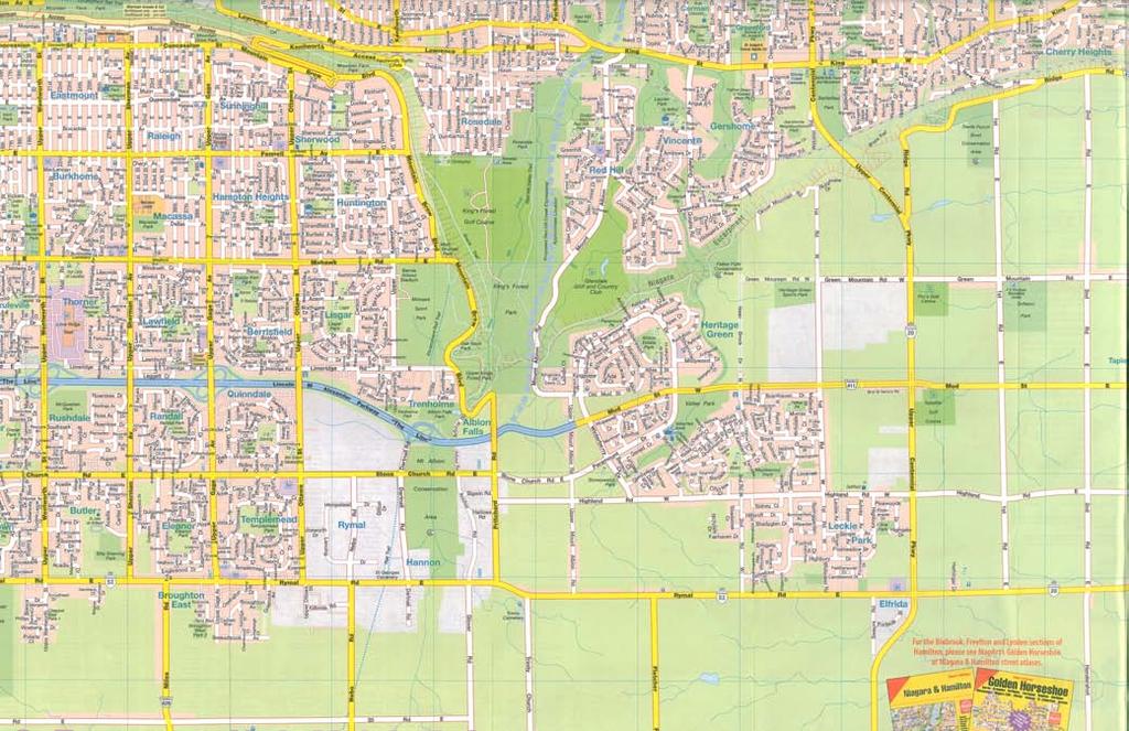
8 Special Policy Area (SPA) C Servicing Study Trinity Neighbourhood Traffic Study North Glanbrook Industrial Business Park Transportation Master Plan Rymal Road Planning Area (ROPA 9) Master Plan Class Environmental Assessment Study Phases 1 and 2 Collector Road and Trinity Neighbourhood Improvements Environmental Assessment for Phases 3 and 4 ROPA 9 and SPA C Transportation Improvements Environmental Assessment for Phases 3 and 4 Trinity Church Corridor Environmental Assessment for Phases 3 and 4 (North & South of Rymal) ROPA 9 & SPA C Water & Wastewater Assessments merged with City Water & Wastewater Master Plan The identification and evaluation of design alternatives and the selection of preferred design alternatives for transportation improvements for the Trinity Church Arterial Corridor are documented in this report summarizing Phases 3 and 4 of the Class EA process. 1.2 Project Location and Study Area The project is located within the City of Hamilton, and spans three former municipalities - the former City of Stoney Creek, the former Township of Glanbrook and the former boundaries of the City of Hamilton. The project Study Area is shown in Exhibit 1-1. June

9
10 1.3 Study Scope and Objectives Findings of the ROPA 9 Master Plan Class EA The preferred planning alternative includes a combination of travel demand management and transit initiatives, new major infrastructure, road widenings and operational improvements. The ROPA 9 Master Plan identified that a north-south link from the Red Hill Valley Parkway to south of Rymal Road is crucial to the broader road network within the City, and would also serve the local community. Providing adequate capacity in this corridor is critical to planning for the economic growth and well-being of the City. The former Region of Hamilton-Wentworth Official Plan recognizes this need, and has highlighted a future extension of Trinity Church Road to the Red Hill Valley Parkway. The ROPA 9 Master Plan also identified the need for a north-south link from the Red Hill Valley Parkway to south of Rymal Road as a longer term solution to address the traffic operations issues within the Trinity Neighbourhood. It recommended that once the new road link was provided, Upper Mount Albion Road could be closed at Rymal Road Findings of the North Glanbrook Industrial Business Park Transportation Master Plan In an effort to spur industrial development and make available shovel ready lands, the City of Hamilton undertook the North Glanbrook Industrial Business Park (NGIBP) Transportation Master Plan to identify a road network that will support the development of the lands in accordance with the current approved land uses identified in the Secondary Plan for the area. The study was necessary in order to plan for the expected increase in traffic on roadways within and adjacent to the NGIBP when development occurs. The NGIBP Transportation Master Plan identified the need for a two lane arterial road from Rymal Road to the future Dartnall Road Extension in the vicinity of Trinity Church Road with the protection for four lanes for the arterial road in the longer term. The Study stated that Trinity Church Road including the east-west extension to the Dartnall Road Extension is a longer term project tied to development in the park as well as growth occurring at the airport. As development in the park should have been established by the time this upgrade is needed, it is feasible and maybe more appropriate to have it constructed as development proceeds as part of a Plan of Subdivision. If driven by airport growth, it may be more appropriate for the City of Hamilton to acquire lands and construct the road in one stage. June
11 1.3.3 Study Objectives and Approach With the approval of the Trinity Church Road improvements north of Rymal Road as part of the Rymal Road Planning Area Master Plan and improvements south of Rymal Road as part of the North Glanbrook Industrial Business Park Transportation Master Plan, it is appropriate that the Schedule C requirements for both projects to be undertaken in one Class EA to be consistent with the direction of the MEA Class EA document Implementation The timing for implementation of the Trinity Church Arterial Corridor segment between Stone Church Road and Rymal Road was discussed in the Rymal Road Planning Area Master Plan, which identified that additional north-south capacity (equivalent to 2 lanes per direction) is needed in the Trinity Church Arterial Corridor by the 2011 time horizon and should be implemented as soon as possible, given design and funding constraints. The North Glanbrook Industrial Business Park Master Plan identified a need for a longerterm extension of the Trinity Church Arterial Corridor to continue south of Rymal Road to service the Business Park and to allow flexibility for a potential future connection to the airport. 1.4 Project Team The Trinity Church Arterial Corridor Environmental Assessment Study is being carried out by a consulting team led by Consulting Inc., on behalf of the City of Hamilton. The Study team is outlined below: City of Hamilton: Christine Lee-Morrison (City Project Manager) Environmental Planning Mohan Philip Strategic Planning Leanne Ryan Traffic Engineering & Operations Harold Groen Functional Planning Tony Sergi Development Engineering Consulting Team: Ray Bacquie (Consultant Project Manager) Consulting Suzette Shiu (Transportation Planning) Consulting Greg Perry (Road Design) Consulting Nathalie Baudais (Project Coordination ) Consulting Christine Hill (Stormwater Management) XCG Grant Kauffman (Natural Environment) LGL Richard Unterman (Cultural Heritage) Unterman McPhail Associates Robert Pihl (Archaeology) Archaeological Services Inc. June
12 1.5 Class Environmental Assessment Process This Environmental Assessment (EA) is being undertaken in accordance with the guidelines of the Municipal Engineers Association Municipal Class Environmental Assessment, June The Environmental Assessment is being conducted in compliance with the guidelines for Schedule A, B, and C projects for the transportation infrastructure components. A brief description of each schedule follows: A Schedule A project is limited in scale, has minimal adverse environmental effects, and includes a number of municipal maintenance and operational activities. Schedule A projects are pre-approved and the proponent may proceed to implementation without following the full Class EA process. A schedule B project has the potential for some adverse environmental effects. Schedule B projects generally include improvements and minor expansions to existing facilities, and the proponent is required to undertake a screening process. A Schedule C project is one that generally involves the construction of new facilities and major expansions of existing facilities, for a total design and construction cost of greater than $1.5 million for roads. Schedule C projects have the potential for significant environmental impact. The Class EA Master Plan summarized the work completed including: 1) background to the Study; 2) the problem statement 3) alternative solutions; 4) a description of the preferred alternative solutions and the rationale for the identification of the preferred alternative solutions; and 5) the public consultation process. This Study will complete the third and fourth phases of the five-phase Class Environmental Assessment Process. Exhibit 1-2 illustrates the sequence of activities within the approved Class Environmental Assessment process leading to project implementation. The encompassing phases for this Study are described below: Phase 3 (Schedule C projects) Examine alternative methods of implementing the preferred solution, based on the existing environment, public and review agency input, anticipated environmental effects, and methods of minimizing negative effects and maximizing positive effects. Phase 4 (Schedule C projects) Document in an Environmental Study Report (ESR) a summary of the rationale, and the planning, design, and consultation process of the project. Phase 5 (Schedule A, B and C projects), which involves detail design, preparation of contract drawings and tender documents, construction, operation, and monitoring, is not part of this Study. The Schedule C project resulting from the Master Plan Studies which will be documented in this Environmental Study Report is the Trinity Church Arterial Corridor. The Class EA Master Plan for the Rymal Road Planning Area was endorsed by City Council on June 14, June
13 2006 and for the NGIBP on July 12, A Notice of Completion will advise the public and other stakeholders of their right to request a Part II Order, and how and when such a request must be submitted. Under the Environmental Assessment Act, if it is felt after consulting with the proponent (the City of Hamilton) that serious environmental concerns remain unresolved, members of the public, interest groups, agencies, and other stakeholders may submit a written request to the Minister of the Environment to require the proponent to comply with Part II of the Environmental Assessment Act before proceeding with the proposed undertaking. Part II of the EA Act addresses Individual Environmental Assessments. The request for a Part II Order must be copied to the proponent at the same time it is submitted to the Minister. Written requests for a Part II Order must be submitted to the Minister within the 30-calendar day review period, after the proponent has filed the Master Plan ESR and has issued the Notice of Completion of the Study. The decision to issue a Part II Order rests with the Minister of the Environment. Requests after the minimum 30-calendar day review period will not be considered by the Minister of the Environment. 1.6 Agency/Stakeholder Consultation A list of agency stakeholders, including federal and provincial ministries, City of Hamilton departments, local groups, conservation authorities, utilities, and developers and their consultants was prepared at the project initiation. The opportunity for these parties to participate in the project was provided through the distribution of a Study Commencement notice. Further opportunity was also provided through announcement of two formal Public Information Centres (PICs). The following is a summary of the agencies contact list. Federal Agencies Canadian Wildlife Services Canadian Environmental Assessment Agency Department of Fisheries and Oceans Environment Canada Parks Canada Provincial Agencies Ontario Realty Corporation Ontario Provincial Police - Burlington Detachment Ministry of Agriculture, Food & Rural Affairs Ministry of Culture / Ministry of Tourism and Recreation Ministry of Community and Social Services Heritage and Libraries Branch, Ministry of Culture Ministry of Natural Resources Ministry of the Environment Ministry of Transportation Ministry of Health and Long Term Care First Nations Six Nations June
14 City of Hamilton Departments Corporate Services Economic Development Hamilton Emergency Services Hamilton Police Services Mayor's Office / Council Planning and Development Public Health and Community Services Public Works Local Groups / Stakeholders Citizens for a Sustainable Community Hamilton Chamber of Commerce Hamilton-Wentworth Catholic School Board Hamilton-Wentworth District School Board Local Architectural Conservation Advisory Committee Ontario Archaeological Society Canadian Center for Inland Waters - Remedial Action Plan (RAP) Resident's Group: Upper Mount Albion Road Conservation Authorities Hamilton Conservation Authority Niagara Peninsula Conservation Authority Niagara Escarpment Commission Business Improvement Areas Barton Village BIA Concession Street BIA Downtown Hamilton BIA Dundas Downtown BIA International Village BIA King Street West BIA Main-West Esplanade BIA Ottawa Street BIA Stoney Creek BIA Waterdown BIA Westdale Village BIA June
15
16 Utilities Bell Canada Cogeco Cable Inc. Enbridge Pipelines Inc. Hydro One Hamilton Hydro Incorporated Hamilton Community Energy Hamilton Utilities Corporation Fibrewired Network - Hamilton Source Cable Limited Ontario Power Generation Union Gas Limited Trans Northern Pipeline TransCanada Pipelines Limited Mountain Cablevision Allstream (formerly ATT & Unitel) Canadian National Railway Canadian Pacific Railway Imperial Oil Products & Chemical Division Sun Canadian Pipeline Developers and their Consultants SmartCentres Counterpoint Engineering Multi-Area Developments Inc. A.J. Clarke and Associates Ltd. LEA Consulting Ltd. Loblaw Properties Limited Delcan Corporation J. Beume Real Estate Ltd. Mr. Joseph Maziarz Mr. Jack Pelech Mr. Nimigan Mr. Lombardi Mr. Dicienzio Silvestri Investments BA Consulting Group Ltd. Arbra Developments Inc. Demik Brothers Ltd. Paletta International Corporation McNally International Inc. Ontario Realty Corporation Correspondences with agencies are provided in Appendix A Summary of Public Consultation Process A comprehensive public consultation program was conducted for the Study, with the following components: Mailing Lists A number of mailing lists were established for the Master Plan Study and were maintained for the Phase 3 and 4 Class Environmental Assessment Study. These included an agency mailing list as mentioned above and a mailing list which consisted of all members of the public within and adjacent to the Study Area, in addition to others who wrote, telephoned, ed, or filled in comment sheets during the Study. People on the mailing list were sent letters prior to each of the public meetings. Opportunities for public input were provided throughout the process, including public meetings, telephone inquiries, letters, and faxes. Stakeholder and Technical Committee Meetings A Stakeholder and Technical Committee was established as part of the Master Plan Study and was maintained for the Phase 3 and 4 Class Environmental Assessment Study. One meeting was held with this group during the Phase 3 and 4 Study. The meeting was held prior to the second Phase 3 and 4 Public Information Centre (PIC). The stakeholders consisted of representatives of June
17 local groups and businesses, and developers. City of Hamilton staff and consultants comprised the technical representatives. Developers and their Consultants A list of developers and their consultants was prepared at the project initiation. The opportunity for these parties to participate in the project was provided through the distribution of a Study Commencement notice. One meeting was held prior to the first Phase 3 and 4 Public Information Centre (PIC) and a mail out update was sent prior to filing the Environmental Study Report. Public Information Centres (PICs) Two formal meetings were held during the Study. They consisted of a public open house with display panels. Attendees were asked to signin when they entered the public open house. A handout consisting of key display panels was made available. Comment forms were available to provide the public another opportunity for input to the Study. Members of the project team were on hand to respond to questions and concerns. Issues raised by the public during and after each meeting were recorded by the consultant team and subsequently addressed. Newspaper advertisements At least one and a half weeks prior to each public meeting, a newspaper advertisement was placed in two separate editions of the Hamilton Spectator and in one edition of the At Your Service, Mountain News, Stoney Creek News, and Glanbrook Gazette to announce the date, time, and location of the meetings. The newspaper advertisements invited the public to attend the meetings and to provide input. The advertisements provided information on contact names, telephone numbers, and addresses. Additional notification At least one and a half weeks prior to each public meeting, a notice of the public meeting was mailed out to area residents and businesses on the project mailing lists. Notification letters were also mailed to utility companies and external agencies. Project address Through the newspaper advertisements and comments sheets, the public was invited to send comments by to both the City and consultant team project managers. Project website As part of the Master Plan Study, a project website was launched to provide the public with an additional means to obtain information about the project. The project website was maintained during the Phase 3 and 4 Study and the website was advertised in the PIC display materials. Further details on the public consultation process are documented in other sections of the report. A summary of the Public Meetings is provided in Appendix A.3. Major events in the Phase 3 and 4 public consultation process are summarized as follows: June
18 Meeting with Six Nations Council June 6, 2006 Notification letters to utility companies, external agencies, June 14, 2006 area businesses, residents and other stakeholders for Public Information Centre Newspaper advertisement of Public Information Centre June 16, 2006 & June 23, 2006 Meeting with Developers and their Consultants June 19, 2006 Public Information Centre June 26, 2006 Notification letters to utility companies, external agencies, September 29, 2006 area businesses, residents and other stakeholders for Public Information Centre Newspaper advertisement of Public Information Centre September 29 & October 6, 2006 Meeting with Stakeholder and Technical Committee October 2, 2006 Public Information Centre October 12, 2006 & October 18, 2006 City of Hamilton Council pre-approval report September 27, 2006 Notice of Study Completion (Phases 3 and 4) June 15, 2007 & June 22, ROPA 9 Master Plan Public Consultation Process During the Problem Statement and Planning Alternatives phases of the ROPA 9 Master Plan, the public consultation process for the Trinity Church Arterial Corridor involved the following activities: First Stakeholder Committee Meeting September 19, 2005 First Public Information Centre October 3, 2005 First Stakeholder Committee Meeting (SC#1) Representatives of the City and the consultant team met with the Stakeholder Committee once during this phase of the project. These meetings provided the SC members an opportunity to meet the project team, gain preliminary information on the project, and discuss any issues relating to the project. At the first meeting, 10 members of the SC were present. Many items were discussed, including: How the EA process works and the role of the SC, City of Hamilton, and the consultant team in this process; SC Terms of Reference; Other studies being carried out in the vicinity of the Study Area which may pertain to this Study; Problem Statement; and The preliminary list of evaluation criteria. The following criterion was added: Adjacent Local Roads (Potential for Traffic Infiltration) June
19 First Public Information Centre (PIC#1) The first Public Information Centre (PIC#1) was held on Tuesday, October 3 rd, 2005 from 6 p.m. to 9 p.m., at the Salvation Army Church Gym, 300 Winterberry Drive (at Paramount Drive), in the City of Hamilton. The purpose of PIC#1 was to provide information about the Study to the public and at the same time obtain public input. Twenty-four panels were displayed. The information panels included the following: Welcome and Study Area Description of the Study background, Study goal and scope Chart of the EA process and class EA requirements Description of the public consultation plan Summary of the needs and opportunities for the Study for transportation, water, and wastewater Problem statement for transportation, water, and wastewater Existing official plan policies and other applicable policies Description of existing conditions Description of 7 transportation alternative solutions Description of 5 water alternative solutions Description of 3 wastewater alternative solutions Description of alternative solutions assessment criteria Evaluation tables of the transportation, water, and wastewater planning alternatives Identification and description of the preferred transportation, water, and wastewater planning alternatives Future actions Contact information As with all of the public information centres, the public was advised about the meeting through advertisements in the local paper. Advertisements were placed in the Hamilton Spectator on Friday September 16, 2005 and Friday September 23, 2005, and in the Brabant papers (Mountain News, Glanbrook Gazette and Stoney Creek News) on Friday September 16, Notification letters were also mailed out to property owners within the Study Area, to other individuals who had responded with an interest in the Study since its commencement, to conservation authorities, Federal and Provincial agencies, and utility companies. The format was an informal drop-in centre from 6:00 to 7:00 PM to meet the project team and to view the display panels and drawings. There was a presentation at 7:00 PM, followed by a question and answer period. The PIC continued until 9:00 PM, which provided participants the opportunity to further discuss the project with the Study team. Attendees were asked to sign-in and were invited to fill-in comment forms at their convenience within a 3-week time frame. June
20 Approximately 122 members of the public attended the PIC. Representatives from the City of Hamilton,, and XCG attended the PIC to discuss the details of the project and answer questions of the public. Key public comments provided on the Trinity Church Arterial Corridor needs assessment were related to the following topics: Need for a new north south link between Rymal Road and the Red Hill Valley Parkway/Stone Church Road ramps, Timing for improvement, Closure of Upper Mount Albion Road; Alignment alternatives; and Potential impacts of a new north-south roadway on adjacent properties, suggestions for consideration of other routes. Further details and documentation regarding the Phase 1 and 2 consultation process can be found in the ROPA 9 Master Plan, June North Glanbrook Industrial Business Park Master Plan Public Consultation Process First Public Information Centre (PIC#1) The first of two Public Information Centres (PIC) was held on Wednesday, June 29, 2005 from 4:00pm to 8:00pm at the Trinity United Church. This PIC was attended by the following members of the project team: Gavin Norman, City of Hamilton Mike Bricks, Ecoplans Limited Jack Thompson, McCormick Rankin Corporation The PIC was attended by 76 people (count from sign-in sheet). The majority of the attendees reside within or nearby the study area. The PIC was an open house with display boards presenting the network alternatives considered, the evaluation of alternatives and the recommended network. Attendees had the opportunity to address and discuss any question or concerns with the project team. Handout copies of the PIC display board and evaluation charts were available. Comment sheets were provided for submission of comments During the PIC 15 comment sheets were submitted. After the PIC additional comments were received and included one fax, four s and four letters. In addition to written comments, five telephone requests for PIC handouts were received by the City of Hamilton. The following table summarizes the written comments received. June
21 In addition to written comments, the following provides a general overview of attendee verbal comments during the Public Information Centre: Impact to residential homes along Trinity Church and concerns re: safety, increased traffic and previous Glanbrook bylaw providing a buffer strip between industrial development and Trinity Church Road should be implemented; Viability of the North Glanbrook Industrial Business Park; Displacement of agricultural land for more industrial land; Support for North Glanbrook Industrial Park since the Red Hill Valley Expressway will provide needed access; Interest in the extent of future sanitary services in study area; Alignment concerns specific to certain landowners; and Redirection of traffic away from roads servicing residential homes Second Public Information Centre (PIC #2) The second and final Public Information Centres (PIC) for the North Glanbrook Industrial Business Park was held on Tuesday, June 16, 2006 from 4:00pm to 8:00pm at the Trinity United Church. This PIC was attended by the following members of the project team: Gavin Norman, City of Hamilton Mike Bricks, Ecoplans Limited Katie Bright, Ecoplans Limited Scott Roberts, McCormick Rankin Corporation The PIC was attended by 63 people (count from sign-in sheet). The majority of the attendees reside within or nearby the study area. The PIC was an open house with display boards presenting the comments from the first PIC, the preferred network, details of the Schedule B projects, future study areas for Schedule C projects and three Dartnall Road Extension alignment alternatives. Attendees had the opportunity to address and discuss any question or concerns with the project team. Handout copies of the PIC display boards were available. Comment sheets were provided for submission of comments. In addition to written comments, the following provides a general overview of attendee verbal comments during the Public Information Centre: Interest in future zoning changes and land use plans within the North Glanbrook Industrial Business Park; Concern regarding the displacement of agricultural land for more industrial land; Concern regarding direct link between the North Glanbrook Industrial Park and the Red Hill Valley Parkway, especially along Trinity Church Road; and Alignment concerns specific to certain landowners. June
22 Further details and documentation regarding the Phase 1 and 2 consultation process can be found in the ROPA 9 Master Plan, June Phase 3 and 4 Consultation The public consultation process and public reaction during the Design Phase for the Trinity Church Arterial Corridor are summarized in Section 4.2 of this report. Additional details on the public consultation process are contained in Appendix A. June
23 2. EXISTING STUDY AREA CONDITIONS This section describes the features of the existing transportation infrastructure in the study area. For information on the existing socio-economic environment, natural environment, surface runoff and utilities, please refer to the Master Plan document. 2.1 Existing Transportation Facilities Road Classification The existing road network and classifications based on the current City s Official Plan designations are illustrated in Exhibit 2-1. The official plan definitions of the road classes and designated right-of-way are noted in Table 2-1. For specifics on any road in the City s road network, refer to the appropriate Official Plan for right-of-way designations. The appropriate volume for the different classes is based on the 1999 Geometric Design Guide for Canadian Roads by the Transportation Association of Canada (TAC) and represents the 24- hour two-direction volume thresholds. Table 2-1: Official Plan Definitions of the Road Classes Current Designation Arterial Collector Local Definition Strategic links in the road network, the main functions of which are to carry relatively high volumes of long distance traffic within, between or through the City and surrounding Area Municipalities and/or to provide access past major geographic barriers and to inter-regional highways. Function as connecting road links between Arterial and Local Roads. They generally carry lower traffic volumes than Arterial Roads and may provide direct access to abutting properties. Provide direct access to abutting properties and carry traffic predominantly of local nature. Designated Right-of-Way Volume for Class 36 m > 5,000 < 30, m <8, m <1,500 For roads in the City of Hamilton, road right-of-way designations can reach up to 60 m and volumes may exceed 30,000 per day. June
24


25 2.1.2 Road Network and Characteristics The study area roads are described below. Rymal Road Rymal Road is an east-west arterial road, with a two-lane, paved rural crosssection and a posted speed limit of 70 km/h. Rymal Road had horizontal curves between Pritchard Road and Trinity Church Road. It intersects with a number of north-south collector and arterial roads. Rymal Road will also provide new collector road connections to the Rymal Road Planning area. Rymal Road has several residential and commercial accesses. No sidewalks are currently provided along the roadway. Parallel east-west roadways north of Rymal Road include Mud Street West and Highland Road East. Golf Club Road parallels Rymal Road to the south of the Study Area. Exhibit 2-2: Rymal Road Westbound (approaching Fletcher Road) June

26 Exhibit 2-3: Rymal Road Westbound (approaching Swayze Road) Trinity Church Road Trinity Church Road is a two-lane north-south arterial south of Rymal Road with a rural cross-section, no shoulders and a posted speed limit of 50 km/h north of the Hydro Corridor and a posted speed limit of 60 km/h south of the Hydro Corridor. Trinity Church Road currently terminates at Rymal Road. The vertical geometry of Trinity Church Road is rolling. A future interchange for the Red Hill Valley Parkway is currently aligned with an extension of Trinity Church Road. Trinity Church Road provides north-south access for the lands in Glanbrook to the south of ROPA 9. There are residential driveways along Trinity Church Road. No sidewalks are provided on either side of the roadway. Exhibit 2-4: Trinity Church Road Northbound (approaching Rymal Road) Upper Mount Albion Road Upper Mount Albion Road is a local road which extends from Mud Street to Rymal Road, and is discontinuous at the Lincoln Alexander Parkway. The road provides direct access to residential properties but provides an arterial road function in the study area road network. It is anticipated that Upper Mount Albion Road will serve more of a local road function (as designated) in the future. Upper Mount Albion Road has a posted speed limit of 60 km/h. The road has a rural cross-section with an average pavement width of approximately 7.5 m and no sidewalks. Upper Mount Albion Road has a rolling terrain. There are several residential accesses and frontages along Upper Mount Albion Road. June

 is located on the northwest corner of the intersection with Highbury Drive.")
27 Exhibit 2-5: Upper Mount Albion Road Northbound (north of Rymal Road) Highland Road Highland Road is a collector road. It has an urban cross-section east of Winterberry Drive and a rural cross-section with an average pavement width of approximately 6.5 m west of Winterberry Drive. There are residential accesses and frontage along Highland Road, which becomes more dense east of Winterberry Drive. A high school (Saltfleet Secondary School) is located on the northwest corner of the intersection with Highbury Drive. A sidewalk is provided on the north side of Highland Road, east of Winterberry Drive. The posted speed limit on Highland Road is 50 km/h, reducing to 40 km/h near Highbury Drive. Exhibit 2-6: Highland Road Eastbound (at Upper Mount Albion Road) Stone Church Road Stone Church Road is an east-west arterial which provides access to Mud Street via Paramount Drive. Stone Church Road has an urban cross-section with paved June


28 shoulders west of Pritchard Road, a rural cross-section with paved shoulders east of Upper Mount Albion Road, and a rural cross-section with gravel shoulders between Upper Mount Albion Road and Pritchard Road. A sidewalk is provided on the south side of Stone Church Road, near Winterberry Drive. Bike lanes are provided on Stone Church Road west of Pritchard Road, and near the intersection with Winterberry Drive. No bike lanes currently exist between Pritchard Road and east of Upper Mount Albion Road. Exhibit 2-7: Stone Church Road Westbound (east of Pritchard Road) Exhibit 2-8: Stone Church Road Eastbound (at Winterberry Drive) June
29 3. PREFERRED PLANNING ALTERNATIVE The Class Environmental Assessment process requires the examination of all reasonable alternatives, including alternatives to the undertaking, referred to as planning alternatives. Through the Master Plan Study, planning alternatives that addressed the problem statement were developed and evaluated and presented to the public. The following transportation improvements were part of the preferred alternatives for the Trinity Church Arterial Corridor, in conjunction with Travel Demand Management initiatives: Traffic controls (signals or roundabout) at: Stone Church Road, Highland Road, future midblock collector road, Rymal Road, and the future extension of Twenty Road; Closure of Upper Mount Albion Road. The ROPA 9 Master Plan (Phase 1 and 2) Study also recommended that: Transit service be considered along the Trinity Church Arterial Corridor with potential new transit stops at intersections with Stone Church Road, Highland Road, proposed trail head for the Red Hill Valley Open Space Replacement Strategy, and Rymal Road; Carpool lot be considered along the Trinity Church Arterial Corridor Sidewalks be considered for the Trinity Church Arterial Corridor; Designated truck route be considered for the Trinity Church Arterial Corridor; and Bicycle routes be considered for the Trinity Church Arterial Corridor. The NGIBP Master Plan recommended the extension of Trinity Church Road from Rymal Road to the Red Hill Valley Parkway (2 lane arterial roadway with protection for 4 lanes) and the provision of an eastwest connection between the south end of the NGIBP area, possibly via Dickenson Road or Airport Road, to the Trinity Church extension. June
30 4. EVALUATION OF DESIGN ALTERNATIVES The Class Environmental Assessment process requires the examination of alternative methods of implementing the preferred undertaking by considering design alternatives. This section of the report provides a discussion on the development and evaluation of the design alternatives for the Trinity Church Arterial Corridor. 4.1 Development and Evaluation of Design Alternatives For the recommended planning alternative, there were a number of possible ways to implement the undertaking. Design alternatives are different ways of implementing the preferred planning alternative. The preferred planning alternatives were determined during the Master Plan Study and are summarized in Section 3 of this report. The advantages and disadvantages of each design alternative were identified and evaluated to determine the best implementation of the undertaking. This is discussed below Development of Design Alternatives The proposed Trinity Church Arterial Corridor design alternatives include the following: Alternative alignments for the Trinity Church Arterial Corridor, Warrants and appropriateness for traffic control devices (traffic control signals or roundabouts) for the intersections with Highland Road, Midblock Collector Road, Rymal Road and the extension of Twenty Road, Provision of urban or rural cross-section, and Storage requirements for auxiliary lanes. Additional roadway enhancements / improvements could include: Enhanced pedestrian environment Enhanced cyclist environment Streetscaping, where feasible Each design alternative was developed and assessed in recognition of the following criteria: June
31 Effect on Transportation Service Corridor Capacity and Level of Service Access for Emergency Vehicles Network Connectivity Compliance with the NGIBP Master Plan Flexibility for Future Network Connections (e.g. Airport) Accommodation for Pedestrians and Cyclists Traffic Safety Access to Adjacent Lands Geometric Standards Transit Operations Travel Demand Management Construction Staging (north of Rymal Road) - Implications on Transportation Effect on Socio-Economic Environment Property Requirements for Right-of-Way Residents Driveways and amenities Privacy / use and enjoyment of property Businesses Property requirements Driveways and amenities Noise Archaeological / Cultural Heritage Resources Air Quality Agriculture Recreation Institutions Ability to Provide Servicing to Adjacent Lands Construction Staging (segment north of Rymal Road) - Implications on Residents / Institutions Traffic impacts on local roads adjacent to the study area Effect on Natural Environment Vegetation Wildlife Aquatic Habitat Eramosa Karst Stormwater Cost Effectiveness Utility Relocation Capital Costs Maintenance and Operation Costs Potential for Contamination Property Acquisition User Costs Each design alternative is described and assessed in further detail below. June
32 Trinity Church Arterial Corridor Alignment Alternatives The six options identified and assessed include do nothing and alternative alignments for a new 4-lane arterial corridor between the Red Hill Valley Ramps and Stone Church Road intersection to south of Rymal Road. The six options are as follows: 1. Do Nothing This alternative was included in the assessment to provide a benchmark against which the other design alternatives could be compared. 2. North-South Connection, East of Existing Trinity Church Road Includes an arterial connection from the Red Hill Valley Parkway and Stone Church Road intersection to south of Rymal Road to accommodate 4 travel lanes (2 per direction). 3. Extension of Existing Trinity Church Road Alignment Includes an arterial connection from the Red Hill Valley Parkway and Stone Church Road intersection to the existing Trinity Church Road at Rymal Road and a widening of the existing Trinity Church Road south of Rymal Road to accommodate 4 travel lanes (2 per direction). 4. North-South Connection, between Existing Trinity Church Road and Pritchard Road Includes an arterial connection from the Red Hill Valley Parkway and Stone Church Road intersection to south of Rymal Road to accommodate 4 travel lanes (2 per direction). 5. North-South Connection, West of Existing Trinity Church Road, Parallel to the Hydro Corridor Includes an arterial connection from the Red Hill Valley Parkway and Stone Church Road intersection to south of Rymal Road to accommodate 4 travel lanes (2 per direction). 6. North-South Connection, West of Existing Trinity Church Road, connecting to Pritchard Road Includes an arterial connection from the Red Hill Valley Parkway and Stone Church Road intersection to south of Rymal Road to accommodate 4 travel lanes (2 per direction). The conceptual alternative alignment options are shown in Exhibit 4-1. June

33
34 Traffic Control Devices The traffic control options identified and assessed for the intersections with Stone Church Road, Highland Road, Midblock Collector Road, Rymal Road and the extension of Twenty Road are listed below: 1. Traffic Signals Includes the provision of traffic signals and exclusive turning lanes. 2. Roundabouts Includes the provision of a roundabout with pedestrian splitter islands Urban or Rural Drainage Design The cross-section options identified and assessed for the Trinity Church Arterial Corridor are as follows: 1. Rural Cross-section Includes the provision of ditches 2. Urban Cross-section Includes the provision of curb and gutter Evaluation of Design Alternatives The evaluation of the design alternatives and recommendations were based on the criteria outlined in Section Reasoned Argument Method was used to evaluate the design alternatives. The reasoned argument can be defined as the art of getting from one sentence to another sentence by valid moves only, using the rules of logic. The Reasoned Argument Method focuses on those criteria that generate a measurable difference between each alternative. Due to the complexity of a new arterial road alignment, the evaluation was completed in two phases, a long list of alternatives and a short list of alternatives. The long list of alternatives was presented to the public in June The short list of alternatives was presented to the public in October June
35 Table 4-1: Analysis and Evaluation of Long List Design Alternatives for the Trinity Church Arterial Corridor ANALYSIS AND EVALUATION OF DESIGN ALTERNATIVES FOR TRINITY CHURCH ARTERIAL CORRIDOR EXTENSION Long List of Alternatives CRITERIA Option 1 Indicator Option 2 Indicator Option 3 Indicator Option 4 Indicator Option 5 Indicator Option 6 Indicator DO NOTHING PT NORTH SOUTH ROAD PT EXTENSION OF PT NEW NORTH-SOUTH PT NEW NORTH-SOUTH PT PT EAST OF EXISTING EXISTING TRINITY ROAD WEST OF ROAD WEST OF TRINITY CHURCH CHURCH ROAD EXISTING TRINITY EXISTING TRINITY ROAD CHURCH ROAD CHURCH ROAD Provides no connection of the Red Hill Valley Parkway ramps at Stone Church Road. TRANSPORTATION SERVICE: Corridor No increase in the Capacity and capacity of corridor and Level of Service to overall study area roadway capacity. Additional north-south capacity will be needed. Would result in significant amounts of traffic on local roads in the area, such as Upper Mount Albion Road. Access for Emergency Vehicles Network Connectivity Same as existing access; however response times would increase with increasing congestion. No improvement to network connectivity. Additional north-south connection would be required. Does not provide good access to the Rymal Road Planning Area (ROPA 9) and North Glanbrook Industrial Business Park. Represents connection of Red Hill Valley Parkway ramps at Stone Church Road via a north-south road which runs parallel to existing Trinity Church Rd. Significant increase in the capacity of corridor and to overall study area roadway capacity. Provides additional two lanes in each direction north of Rymal Road and additional two lanes in each direction south of Rymal Road. Access for emergency vehicles may improve as an additional route choice would be available. Network connectivity will be significantly improved. Provides good network continuity with additional north-south connection. Allows for good access to the Rymal Road Planning Area (ROPA 9) and North Glanbrook Industrial Business Park. Represents extension of Trinity Church Road from Rymal Road to Red Hill Valley Parkway Ramp at Stone Church Road and widening of existing Trinity Church Road South Of Rymal Road. Increase in the capacity of corridor and to overall study area roadway capacity. Provides additional two lanes in each direction north of Rymal Road and additional one lane in each direction south of Rymal Road. Access for emergency vehicles may improve as an additional route choice would be available. Network connectivity will be significantly improved. Provides good network continuity with additional north-south connection. Allows for good access to ROPA 9 and North Glanbrook Industrial Business Park. Represents connection of Red Hill Valley Parkway ramps at Stone Church Road via a north-south road which runs parallel to existing Trinity Church Rd between Pritchard Road and existing Trinity Church Road. Significant increase in the capacity of corridor and to overall study area roadway capacity. Provides additional two lanes in each direction north of Rymal Road and additional two lanes in each direction south of Rymal Road. Access for emergency vehicles may improve as an additional route choice would be available. Network connectivity will be significantly improved. Provides good network continuity with additional north-south connection. Allows for good access ROPA 9 and North Glanbrook Industrial Business Park. Represents connection of Red Hill Valley Parkway ramps at Stone Church Road via a north-south road which connects to Rymal Road in the vicinity of Pritchard Road and runs parallel to existing Trinity Church Rd south of Pritchard Road. Increase in the capacity of corridor and to overall study area roadway capacity. Provides additional two lanes in each direction north of Rymal Road and additional two lanes in each direction south of Rymal Road, but requires the closure of Pritchard Road. Access for emergency vehicles may improve as an additional route choice would be available. Network connectivity will be significantly improved. Provides good network continuity with additional north-south connection. Allows for good access ROPA 9 and North Glanbrook Industrial Business Park. NEW NORTH-SOUTH ROAD WEST OF EXISTING TRINITY CHURCH ROAD (AT PRITCHARD) Represents connection of Red Hill Valley Parkway ramps at Stone Church Road via a north-south road which connects to Rymal Road at Pritchard Road and runs parallel to existing Trinity Church Rd south of Pritchard Road. Increase in the capacity of corridor and to overall study area roadway capacity. Provides additional two lanes in each direction north of Rymal Road and additional two lanes in each direction south of Rymal Road, but requires the closure of Pritchard Road. Access for emergency vehicles may improve as an additional route choice would be available. Network connectivity will be significantly improved. Provides good network continuity with additional north-south connection. Allows for good access ROPA 9 and North Glanbrook Industrial Business Park. LEGEND most preferred least preferred June
City of Toronto. Emery Village Transportation Master Plan
 City of Toronto Emery Village Transportation Master Plan May 2009 Emery Village Transportation Master Plan Toronto, ON May 2009 Consulting Inc. 100 York Blvd., Suite 300 Richmond Hill, ON L4B 1J8 Tel:
Public Information Centre #1
 and Highway 401 Interchange Improvements WELCOME Public Information Centre #1 Veterans Memorial Parkway Extension and Highway 401 Interchange Improvements Study May 23, 2012 4 p.m. to 7 p.m. Brief Overview
Portage Parkway Environmental Assessment Public Information Centre No. 1
 City of Vaughan Portage Parkway Environmental Assessment Public Information Centre No. 1 November 25, 2015 Welcome to the Public Information Centre This first Public Information Centre (PIC) introduces
Commissioners Road West Realignment Environmental Assessment
 City of London Commissioners Road West Realignment Environmental Assessment Public Information Centre No. 1 March 30, 2017 Welcome to the Public Information Centre This first Public Information Centre
Heritage Road Improvements from Steeles Avenue to Rivermont Road
 The Corporation of the City of Brampton Heritage Road Improvements from Steeles Avenue to Rivermont Road Class Environmental Assessment Study (Schedule C) September 19, 2013 The Corporation of the City
Mavis Road Class Environmental Assessment
 Mavis Road Class Environmental Assessment Public Information Centre #2 Wednesday November 9, 2016 6:00 to 8:00 p.m. Please sign in and complete a comment sheet Review the displays on your own or join in
Commissioners Road West Realignment Environmental Assessment
 City of London Commissioners Road West Realignment Environmental Assessment Public Information Centre No. 2 November 29, 2017 Welcome to the Public Information Centre This 2 nd Public Information Centre
9 CITY OF VAUGHAN OFFICIAL PLAN AMENDMENT NO BOCA EAST INVESTMENTS LIMITED
 9 CITY OF VAUGHAN OFFICIAL PLAN AMENDMENT NO. 631 - BOCA EAST INVESTMENTS LIMITED The Planning and Economic Development Committee recommends the adoption of the recommendations contained in the following
Second Line West Pedestrian/Cyclist Crossing of Highway 401 Class EA. Second Line West Pedestrian/Cyclist Crossing of Highway 401 Class EA
 1 1 Purpose of Public Information Centre #2 To provide interested and/or potentially affected stakeholders with an opportunity to participate in the planning and decision-making process for this Municipal
St. Clair Avenue West Area Transportation Master Plan
 1 (Between Keele Street and Old Weston Road) Public Information Centre 1 December 2, 2015 2 Welcome Welcome to the first Public Information Centre for the St. Clair Avenue West Area. The panels will present
Welcome. Date: Thursday March 2, 2017 Time: 6:30 p.m. 9:00 p.m. Location: Woodview School Gym, 69 Flatt Road, Burlington Presentation Time: 7:00 p.m.
 Welcome Public Information Centre No.2 City of Burlington, City of Hamilton, Region of Halton Waterdown Road Widening Detailed Design Craven Avenue to Mountain Brow Road Date: Thursday March 2, 2017 Time:
Municipal Class EA Study Public Information Centre No. 1 December 13, :00 pm 7:00 pm. Please sign in so we can keep you updated on this study
 Reconstruction of Regional Road 45 (Creek Road) Between Regional Road 27 (River Road) and Regional Road 63 (Canborough Road) in the Township of Wainfleet Municipal Class EA Study Public Information Centre
Bostwick Road. Municipal Class Environmental Assessment. Public Information Centre #2 June 14, City of London
 Bostwick Road Municipal Class Environmental Assessment Public Information Centre #2 June 14, 2017 Welcome! Welcome to the 2 nd Public Information Centre for the. Representatives from the and the consulting
Rapid Transit Implementation Working Group September 14, 2017
 Rapid Transit Implementation Working Group September 14, 2017 BACKGROUND Council approved the Rapid Transit Master Plan and Updated Business Case on July 25, 2017. Approval of the RTMP confirmed the BRT
The West Vaughan Employment Area Secondary Plan Policies
 Part 2: The West Vaughan Employment Area Secondary Plan Policies 2.1 General Policies It is the policy of Council: 2.1.1. That the West Vaughan Employment Area (the WVEA), identified on Schedule 1, will
TABLE OF CONTENTS Page
 TABLE OF CONTENTS Table of Contents Page 1 INTRODUCTION... 1-1 1.1 Introduction and Background... 1-1 1.1.1 Current Class Environmental Assessment Study... 1-1 1.2 Study Area (Section 1)... 1-3 1.3 Ontario
FANSHAWE PARK ROAD/RICHMOND STREET INTERSECTION IMPROVEMENTS. PUBLIC INFORMATION CENTRE 2 June 16, 2016
 FANSHAWE PARK ROAD/RICHMOND STREET INTERSECTION IMPROVEMENTS Municipal Class Environmental Assessment PUBLIC INFORMATION CENTRE 2 June 16, 2016 ACCESSIBILITY Under the Accessibility Standards 2015 for
The Illinois Department of Transportation and Lake County Division of Transportation. Route 173, including the Millburn Bypass
 The Illinois Department of Transportation and Lake County Division of Transportation welcome you to this Public Hearing for U.S. Route 45 from Illinois Route 132 to Illinois Route 173, including the Millburn
WELCOME TO OPEN HOUSE TWO November 28, 2018
 Langstaff Road Weston Road to Highway 7 Class Environmental Assessment Study WELCOME TO OPEN HOUSE TWO November 28, 2018 Please sign in and join our mailing list Study Overview York Region is conducting
Emery Village Road 2A Municipal Class Environmental Assessment Study
 PW12.11 STAFF REPORT ACTION REQUIRED Emery Village Road 2A Municipal Class Environmental Assessment Study Date: March 30, 2016 To: From: Wards: Reference Number: Public Works and Infrastructure Committee
Bostwick Road. Municipal Class Environmental Assessment. October 13, City of London. Bostwick Road Municipal Class Environmental Assessment
 Bostwick Road Municipal Class Environmental Assessment October 13, 2016 Welcome! Welcome to the first Public Information Centre for the Bostwick Road Municipal Class Environmental Assessment. Representatives
SECTION 4(f) DE MINIMIS DOCUMENTATION
 DE MINIMIS DOCUMENTATION") SECTION 4(f) DE MINIMIS DOCUMENTATION Illinois Route 60/83 IL 176 to the intersection of IL 60 (Townline Road) Lake County P-91-084-07 Mundelein Park and Recreation District Project Limit SECTION 4(f)
SECTION 4(f) DE MINIMIS DOCUMENTATION Illinois Route 60/83 IL 176 to the intersection of IL 60 (Townline Road) Lake County P-91-084-07 Mundelein Park and Recreation District Project Limit SECTION 4(f)
Services Department F May 28, 2007
 Report To: Development Services Committee Item: Date of Report: From: DS-07-144 May 23, 2007 Commissioner, Development File: Date of Meeting: Services Department F-7000-0013 May 28, 2007 Subject: Gibb
CONSULTING SERVICES FOR THE WHITEBELT VISIONING EXERCISE ADDENDUM TO THE GTA WEST LAND USE STUDY WORK PROGRAM
 CONSULTING SERVICES FOR THE WHITEBELT VISIONING EXERCISE ADDENDUM TO THE GTA WEST LAND USE STUDY 1. Introduction WORK PROGRAM The Town of Caledon is a large, local municipality located in the Greater Toronto
COUNCIL ATTACHMENT 2 HIGHWAY 7 CORRIDOR AND VAUGHAN NORTH-SOUTH LINK
 COUNCIL ATTACHMENT 2 HIGHWAY 7 CORRIDOR AND VAUGHAN NORTH-SOUTH LINK Welcome! The purpose today is to: Present the Study Background; Describe Alignment Alternatives Analyzed; Present the Evaluation of
1.0 INTRODUCTION AND BACKGROUND
 1.0 INTRODUCTION AND BACKGROUND 1.1 INTRODUCTION / BACKGROUND The Regional Municipality of York (hereafter referred to as York Region ) has completed a Municipal Class Environmental Assessment (Class EA)
8 Oak Street - Official Plan and Zoning By-law Amendment Application - Preliminary Report
 STAFF REPORT ACTION REQUIRED 8 Oak Street - Official Plan and Zoning By-law Amendment Application - Preliminary Report Date: March 17, 2014 To: From: Wards: Reference Number: Planning and Growth Management
City of Cornwall Municipal Class Environmental Assessment. Proposed Improvement and Extension of Lemay Street
 Welcome City of Cornwall Municipal Class Environmental Assessment Proposed Improvement and Extension of Lemay Street Redevelopment and Design of the Municipal Works Yard Public Information Centre #1 Thursday,
Director, Community Planning, Toronto and East York District
 Lower Yonge Precinct Plan Update STAFF REPORT ACTION REQUIRED Date: October 16, 2012 To: From: Wards: Reference Number: Toronto and East York Community Council Director, Community Planning, Toronto and
SPECIAL COMMITTEE OF THE WHOLE DECEMBER 9, 2002 BLOCK 57/58 WEST BLOCK PLAN BLOCK PLAN FILE BL.57/58W.99 HUNTINGTON BUSINESS PARK LAND OWNERS
 SPECIAL COMMITTEE OF THE WHOLE DECEMBER 9, 2002 BLOCK 57/58 WEST BLOCK PLAN BLOCK PLAN FILE BL.57/58W.99 HUNTINGTON BUSINESS PARK LAND OWNERS Recommendation The Commissioner of Planning recommends: THAT
MUNICIPALITY OF NORTH GRENVILLE. PROPOSED WATERFRONT TRAILS AND PEDESTRIAN BRIDGE ON THE SOUTH BRANCH OF THE RIDEAU RIVER Kemptville, Ontario
 MUNICIPALITY OF NORTH GRENVILLE PROPOSED WATERFRONT TRAILS AND PEDESTRIAN BRIDGE ON THE SOUTH BRANCH OF THE RIDEAU RIVER Kemptville, Ontario MUNICIPAL CLASS ENVIRONMENTAL ASSESSMENT, SCHEDULE B Project
Vaughan Metropolitan Centre (VMC) Black Creek Renewal CLASS ENVIRONMENTAL ASSESSMENT
 Black Creek Renewal CLASS ENVIRONMENTAL ASSESSMENT") PUBLIC INFORMATION CENTRE Vaughan Metropolitan Centre (VMC) Black Creek Renewal Wednesday, May 10, 2017 6:00 p.m. to 8:00 p.m. Add photo Project Management, Environmental Assessment, Stormwater Management
PUBLIC INFORMATION CENTRE Vaughan Metropolitan Centre (VMC) Black Creek Renewal Wednesday, May 10, 2017 6:00 p.m. to 8:00 p.m. Add photo Project Management, Environmental Assessment, Stormwater Management
The purpose of tonight s PIC is to:
 The purpose of tonight s PIC is to: Provide an overview of the work completed to date and a summary of the Class EA process being followed; Provide a summary of public input received so far, including
Outline Plan in Belvedere (Ward 9) at Street SE, LOC (OP)
 at Street SE, LOC (OP)") 2018 October 04 Page 1 of 12 EXECUTIVE SUMMARY This outline plan application was submitted by B&A Planning Group on 2016 July 15, on behalf of Tristar Communities Inc. for 50.14 hectares (123.89 acres)
2018 October 04 Page 1 of 12 EXECUTIVE SUMMARY This outline plan application was submitted by B&A Planning Group on 2016 July 15, on behalf of Tristar Communities Inc. for 50.14 hectares (123.89 acres)
Elfrida Growth Area Study
 Elfrida Growth Area Study Public Information Centre #2 December 6, 2017 6:00-8:30 pm PLANNING & ECONOMIC DEVELOPMENT DEPARTMENT Purpose of the Study The Elfrida Area has been identified as the preferred
Elevated Water Storage Facility and Pumping Station Municipal Class EA for Pressure District 7: PIC # 1 Summary
 Memorandum DATE: March 14, 2018 TO: FROM: CC: OUR REF.#: SUBJECT: Winston Wang, M.A.Sc., P.Eng Project Manager, City of Hamilton Jennifer Whittard, B.E.S., PMP Shelley Kuan, Jessica Mollo WM16-0435 Elevated
Services Department B September 10, 2007
 Report To: Development Services Committee Item: Date of Report: DS-07-246 September 5, 2007 From: Commissioner, Development File: Date of Meeting: Services Department B7200-0001 September 10, 2007 Subject:
The MSII reports for the bridge indicate that the Annual Average Daily Traffic at the bridge is 100. The road can be considered a low volume road.
 Page 1 1 INTRODUCTION 1.1 Background The Bronk Road Bridge is located on Bronk Road about 0.2 km north of Thrasher Road and spans Parks Creek, a tributary of the Moira River. Bronk Road is the road allowance
Request for Decision. Recommendation. Presented: Monday, Jul 07, Report Date Friday, Jun 20, Type: Public Hearings
 Presented To: Planning Committee Request for Decision Application for rezoning in order to permit a place of worship on a vacant lot zoned for C1, Local Commercial uses, Cam Street, Sudbury Sitiri Investments
Commissioners Road West. Municipal Class Environmental Assessment. City of London
 Commissioners Road West Municipal Class Environmental Assessment Commissioners Road West Realignment from Springbank Drive/Byron Baseline Road to Cranbrook Road ENVIRONMENTAL STUDY REPORT B000615 Commissioners
Study Process / Planning Policy Issues
 Memorandum Date: March 13 th, 2009 To: From: Reference: Subject: Murray Thompson, URS Canada Tyler Drygas, Senior Environmental Planner, URS Canada Detroit River International Crossing Study Response to
3 Development Process 3.1 Stage One page Stage Two page Stage Three page CENTRAL PICKERING DEVELOPMENT PLAN
 3 Development Process 3.1 Stage One page 24 3.2 Stage Two page 25 3.3 Stage Three page 28 22 CENTRAL PICKERING DEVELOPMENT PLAN The Central Pickering Development Plan establishes the key elements of new
2. AGENCY COORDINATION AND PUBLIC INVOLVMENT
 2. AGENCY COORDINATION AND PUBLIC INVOLVMENT This chapter discusses the process carried out for conducting agency coordination and public involvement activities. TECHNICAL ADVISORY COMMITTEE A Technical
APPENDIX L3. Table of Contents. SWP EA Information Sheets
 E N V I R O N M E N T A L A S S E S S M E N T APPENDIX L3 SWP EA Information Sheets Table of Contents EA Info Sheet 1... L3-1 EA Info Sheet 2... L3-3 EA Info Sheet 3... L3-5 EA Info Sheet 4... L3-7 SCARBOROUGH
Transportation Master Plan Schedule B Projects Road Name From To Description of Works Southcote Road Garner Road Twenty Road Extension
 NOTICE OF STUDY COMPLETION CLASS ENVIRONMENTAL ASSESSMENT STUDY Municipal Class Environmental Assessment for Hamilton Airport Employment Growth District Background The Airport Employment Growth District
MAYFIELD WEST SECONDARY PLAN PHASE 2
 MAYFIELD WEST SECONDARY PLAN PHASE 2 Council Information Workshop February 16, 2010 Draft Preferred Land Use Plan TOWN OF CALEDON PLANNING & DEVELOPMENT DEPARTMENT Workshop Agenda TOWN OF CALEDON 1. Welcome
OP Council Resolution June 16, Planning and Development Services
 OP-08-01 Council Resolution June 16, 2008 Planning and Development Services Kingsgate Landing Outline Plan Table of Contents 1.0 Introduction 1 1.1 Purpose of Plan 1 1.2 Plan Area Location 1 1.3 Ownership
Update. What is the Osborne Bridge Rehabilitation project all about and how is it being planned? Neighbourhood Advisory Committee (NAC)
") Update JANUARY 2010 Neighbourhood Advisory Committee (NAC) ARTS AND CULTURE Gas Station Theatre BUSINESS Osborne Village BIZ Downtown BIZ COMMERCIAL PROPERTY OWNER Great-West Life COMMUNITY ORGANIZATIONS
Update JANUARY 2010 Neighbourhood Advisory Committee (NAC) ARTS AND CULTURE Gas Station Theatre BUSINESS Osborne Village BIZ Downtown BIZ COMMERCIAL PROPERTY OWNER Great-West Life COMMUNITY ORGANIZATIONS
North York Centre South Service Road
 North York Centre South Service Road Municipal Class Environmental Assessment Addendum Potential Changes to Doris Avenue, Bonnington Place & Tradewind Avenue Study Summary (June 11, 2015) toronto.ca/nyc-south-road.
Public Information Centre. Welcome
 Transportation Improvements from the Beaver Creek Bridge to the Entrance of Santa s Village District of Muskoka Municipal Class Environmental Assessment Welcome Please sign in Take a comment sheet Staff
Master Environmental Servicing Plan & Secondary Plan
 East Side Lands Stage 2 1 Master Environmental Servicing Plan & Secondary Plan Public Information Centre #1 June 16, 2016 Welcome! Today s Agenda Please sign in at the front desk. 5:30 pm 6:30 pm: Open
6 Growth Management Challenges and Opportunities
 6 Growth Management Challenges and Opportunities The Town has established a goal of attaining a 50% participation rate with respect to employment opportunities versus residential population. The Town s
Welcome. Walk Around. Talk to Us. Write Down Your Comments
 Welcome This is an information meeting introducing the applications for proposed redevelopment of the Yorkdale Shopping Centre site at 3401 Dufferin Street and 1 Yorkdale Road over the next 20+ years,
THE GARDEN CITY PLAN. City of St. Catharines Official Plan. City of St. Catharines
 THE GARDEN CITY PLAN City of St. Catharines Official Plan City of St. Catharines August 2010 APPROVAL INFORMATION This Official Plan of the City of St. Catharines Planning Area, known as the Garden City
Environmental Study Report
 Environmental Study Report Britannia Road (Regional Road 6) Transportation Corridor Improvements The Regional Municipality of Halton TN1390TNA00 The Regional Municipality of Halton 1151 Bronte Road Oakville,
Master Environmental Servicing Plan & Secondary Plan
 1 East Side Lands Stage 2 Master Environmental Servicing Plan & Secondary Plan Public Consultation Centre #4 March 20, 2018 Welcome! Today s Agenda Please sign in at the registration table. 6:00 pm 6:30
VILLAGE OF BOLTON HERITAGE CONSERVATION DISTRICT PLAN
 Page 1 1. INTRODUCTION AND BACKGROUND 1.1 THE PROJECT VILLAGE OF BOLTON HERITAGE CONSERVATION DISTRICT PLAN TERMS OF REFERENCE The Town of Caledon (Town) is a large, predominantly rural municipality with
PUBLIC HEARING. Thursday, December 14, 2017 FDOT Urban Office 2198 Edison Avenue Jacksonville, FL 32204
 DISTRICT TWO PUBLIC HEARING I 10 (SR 8) from I 295 to I 95 Project Development & Environment Study Duval County, Florida Financial Project Number 213326 2 22 01 Efficient Transportation Decision Making
TOWN OF WHITBY REPORT RECOMMENDATION REPORT
 TOWN OF WHITBY REPORT RECOMMENDATION REPORT REPORT TO: Council REPORT NO: PL 95-09 DATE OF MEETING: October 13, 2009 PREPARED BY: Planning/Public Works Joint Report FILE NO(S): N/A LOCATION: N/A REPORT
Report to: Development Services Committee Report Date: September 11, 2017
 ~RKHAM Report to: Development Services Committee Report Date: September 11, 2017 SUBJECT: PREPARED BY: Conceptual Master Plan for the Future Urban Area - Community Structure Plan and Key Policy Direction
TORONTO COMPLETE STREETS GUIDELINES
 TORONTO COMPLETE STREETS GUIDELINES Presentation by Fiona Chapman, Manager, Pedestrian Projects Public Realm Section, Transportation Services, City of Toronto June 2017 PURPOSE OF THE PROJECT To develop
CITY OF VAUGHAN EXTRACT FROM COUNCIL MEETING MINUTES OF JUNE 7, 2016
 Item 5, Report No. 26, of the Committee of the Whole (Working Session), which was adopted without amendment by the Council of the City of Vaughan on June 7, 2016. 5 MUNICIPAL CLASS ENVIRONMENTAL ASSESSMENT
II PREVIOUS REPORTS PERTINENT TO THIS MATTER II
 ~ ~~ ~~~ ~ ~~ ~ ~~~~ ~ ~~ ~~ ~~~~ ~ Agenda Item # Page # TO: FROM: -..-.-I- 3UBJCL I CHAIR AND MEMBERS ENVIRONMENT AND TRANSPORTATION COMMITTEE MEETING ON OCTOBER 17,2005 DAVID A. LECKIE, P. ENG DIRECTOR
WELCOME TO PUBLIC INFORMATION CENTRE #2. Please Sign In
 WELCOME TO PUBLIC INFORMATION CENTRE #2 Replacement of Oxtongue Lake Narrows Bridge & Oxtongue River Bridge, Highway 60 (G.W.P. 93-89-00 & G.W.P. 5550-04-00) Class Environmental Assessment (Group B) Please
Don Mills Crossing Study and Celestica Lands Development Application Community Meeting, Open House, and Breakout Discussions
 Consultation Summary Don Mills Crossing Study and Celestica Lands Development Application Community Meeting, Open House, and Breakout Discussions This report is not intended to provide a verbatim transcript
Land Use Amendment in Southwood (Ward 11) at and Elbow Drive SW, LOC
 at and Elbow Drive SW, LOC") 2018 November 15 Page 1 of 10 EXECUTIVE SUMMARY This land use amendment application was submitted by Rick Balbi Architect on 2017 August 31 on behalf of Sable Developments Ltd, and with authorization from
2018 November 15 Page 1 of 10 EXECUTIVE SUMMARY This land use amendment application was submitted by Rick Balbi Architect on 2017 August 31 on behalf of Sable Developments Ltd, and with authorization from
Preliminary Design of Major Rehabilitation Works for the Bridge Structure on PTH 1A Over Assiniboine River and CP Rail (Bridge Site No.
 Preliminary Design of Major Rehabilitation Works for the Bridge Structure on PTH 1A Over Assiniboine River and CP Rail (Bridge Site No. 2582-00) Public Consultation Report December 2014 First Street Bridge
Introduction. Public Information Package. Project website. Overview. Class Environmental Assessment Process
 1 Introduction Public Information Package Baseline Road Extension between Lambs Road and Bennett Road, Bowmanville Schedule B Municipal Class Environmental Assessment November 6, 2017 Overview The purpose
Public Hearing. Charlotte County-Punta Gorda MPO - Meeting Rooms A and B March 14, open house at 4 p.m., formal presentation at 5 p.m.
 Public Hearing Charlotte County-Punta Gorda MPO - Meeting Rooms A and B March 14, 2019 open house at 4 p.m., formal presentation at 5 p.m. Welcome to the Public Hearing for the Harborview Road (CR 776)
Purpose of Open House #3
 Public Meeting #3 May 9, 2009 MVVA Team Purpose of Open House #3 The main purpose of this Open House is to present and seek input on the: Evaluation of transportation and infrastructure design alternatives
Public Meeting #3 May 9, 2009 MVVA Team
 Public Meeting #3 May 9, 2009 MVVA Team Welcome to the third Public Meeting for the Lower Don Lands Municipal Class Environmental Assessment (EA) Infrastructure Master Plan and Keating Channel Precinct
New York Avenue Streetscape and Trail Project Public Meeting #1 Summary
 New York Avenue Streetscape and Trail Project Public Meeting #1 Summary I. King Jordan Student Academic Center (SAC) Gallaudet University, Washington, DC February 23, 2017 Table of Contents 1.0 Introduction...
The Village of Sugar Grove, in partnership with Kane County, the Illinois Department of Transportation, and the Illinois Tollway welcomes you to the
 The Village of Sugar Grove, in partnership with Kane County, the Illinois Department of Transportation, and the Illinois Tollway welcomes you to the first Public Meeting for the proposed interchange improvement
Highway 427 Industrial Secondary Plan Area 47 Schedule C Class Environmental Assessment For Arterial Roadways
 Welcome to Pubic Information Centre #1 Highway 427 Industrial Secondary Plan Area 47 Schedule C Class Environmental Assessment For Arterial Roadways Welcome to Open House # 1 Tonight, we invite you to.
Creating Complete Roadway Corridors:
 Creating Complete Roadway Corridors: The AASHTO Guide to Transportation Landscape Architecture and Environmental Design NCHRP Project 15-33 Status Report AASHTO Standing Committee on Design Technical Committee
ROAD CLOSURE AND LAND USE AMENDMENT SILVER SPRINGS (WARD 1) NORTHEAST OF NOSEHILL DRIVE NW AND SILVER SPRINGS ROAD NW BYLAWS 2C2018 AND 29D2018
 NORTHEAST OF NOSEHILL DRIVE NW AND SILVER SPRINGS ROAD NW BYLAWS 2C2018 AND 29D2018") Page 1 of 19 EXECUTIVE SUMMARY This application proposes redesignating two parcels in the community of Silver Springs from Special Purpose Future Urban Development (S-FUD) District and undesignated road
Page 1 of 19 EXECUTIVE SUMMARY This application proposes redesignating two parcels in the community of Silver Springs from Special Purpose Future Urban Development (S-FUD) District and undesignated road
Red Hill Valley Project More Than A Road October 16, 2006
 Red Hill Valley Project Presented By: More Than A Road October 16, 2006 September, 2007 Gerry Davis, C.M.A., Senior Director, Capital Planning and Implementation Division Public Works Department City of
Potential Green Infrastructure Strategies May 6, 2015 Workshop
 Potential Green Infrastructure Strategies May 6, 2015 Workshop Background The City of Cortland is developing the Tioughnioga Urban Headwaters Green Infrastructure Action Plan with funding from the National
WELCOME TO THE PUBLIC INFORMATION CENTRE. Please Sign In
 WELCOME TO THE PUBLIC INFORMATION CENTRE Replacement of Oxtongue Lake Narrows Bridge & Oxtongue River Bridge, Highway 60 (G.W.P. 93-89-00 & G.W.P. 5550-04-00) Class Environmental Assessment (Group B) Please
PUBLIC OPEN HOUSE HURONTARIO-MAIN CORRIDOR SECONDARY PLAN
 PUBLIC OPEN HOUSE HURONTARIO-MAIN CORRIDOR SECONDARY PLAN Tuesday, February 28, 2012 6pm 9pm 1 st Floor Atrium, City Hall 2 Wellington Street West, Brampton 1 POLICY FRAMEWORK The 2006 Provincial Growth
CHAPTER 7: VISION AND ACTION STATEMENTS. Noble 2025 Vision Statement
 CHAPTER 7: VISION AND ACTION STATEMENTS This chapter presents the vision, policy and action statements that transform the comprehensive planning study, an analysis of Noble s past, future trends and community
3 MARKHAM NORTH-SOUTH LINK CORRIDOR PUBLIC TRANSIT IMPROVEMENTS ENVIRONMENTAL ASSESSMENT UPDATE
 3 MARKHAM NORTH-SOUTH LINK CORRIDOR PUBLIC TRANSIT IMPROVEMENTS ENVIRONMENTAL ASSESSMENT UPDATE The Rapid Transit Public/Private Partnership Steering Committee recommends the adoption of the recommendations
Dundas Street (Regional Road 5) Improvements Class Environmental Assessment Study
 Improvements Class Environmental Assessment Study") REGION Dundas Street (Regional Road 5) Improvements Class Environmental Assessment Study Brant Street (Regional Road 18) to Bronte Road (Regional Road 25) ENVIRONMENTAL STUDY REPORT May 2015 DUNDAS STREET
REGION Dundas Street (Regional Road 5) Improvements Class Environmental Assessment Study Brant Street (Regional Road 18) to Bronte Road (Regional Road 25) ENVIRONMENTAL STUDY REPORT May 2015 DUNDAS STREET
1.0 Purpose of a Secondary Plan for the Masonville Transit Village
 Report to Planning and Environment Committee To: Chair and Members Planning & Environment Committee From: John M. Fleming Managing Director, Planning and City Planner Subject: Masonville Transit Village
Planning and Growth Management Committee. Chief Planner and Executive Director, City Planning Division. Pg12013 (File No NNY 34 OZ)
") 865 York Mills Road Official Plan Amendment Application Preliminary Report STAFF REPORT ACTION REQUIRED Date: February 28, 2012 To: From: Wards: Reference Number: Planning and Growth Management Committee
865 York Mills Road Official Plan Amendment Application Preliminary Report STAFF REPORT ACTION REQUIRED Date: February 28, 2012 To: From: Wards: Reference Number: Planning and Growth Management Committee
Bloor St. W. Rezoning - Preliminary Report
 STAFF REPORT ACTION REQUIRED 1638-1644 Bloor St. W. Rezoning - Preliminary Report Date: April 1, 2008 To: From: Wards: Reference Number: Toronto and East York Community Council Acting Director, Community
AMENDMENT NO. 30 TO THE OFFICIAL PLAN OF THE TOWN OF MILTON
 AMENDMENT NO. 30 TO THE OFFICIAL PLAN OF THE TOWN OF MILTON Subject: Boyne Survey Secondary Plan and Related Official Plan Amendments The following text and schedules constitute Amendment No. 30 to the
Western Road/Wharncliffe Road North Widening from Platts Lane to Oxford Street. Municipal Class Environmental Assessment Public Information Centre #1
 Western Road/Wharncliffe Road North Widening from Platts Lane to Oxford Street Municipal Class Environmental Assessment Public Information Centre #1 June 11, 2014 Welcome Welcome to the first Public Information
240 and 242 Finch Avenue West Zoning By-law Amendment Application Preliminary Report
 REPORT FOR ACTION 240 and 242 Finch Avenue West Zoning By-law Amendment Application Preliminary Report Date: March 1, 2019 To: North York Community Council From: Director, Community Planning, North York
John M. Fleming Managing Director, Planning and City Planner. Old East Village Dundas Street Corridor Secondary Plan Draft Terms of Reference
 Report to Planning and Environment Committee To: From: Subject: Chair and Members Planning & Environment Committee John M. Fleming Managing Director, Planning and City Planner Old East Village Dundas Street
Background Summary Report
 Background Summary Report May 2014 Submitted by Macaulay Shiomi Howson Ltd. In association with AMEC MMM Group Brook McIlroy Inc. Hemson Consulting Ltd. Table of Contents 1. Introduction... 1 2. Why is
280 Manse Road - Official Plan Amendment, Zoning Amendment, Draft Plan of Subdivision Applications - Preliminary Report
 STAFF REPORT ACTION REQUIRED 280 Manse Road - Official Plan Amendment, Zoning Amendment, Draft Plan of Subdivision Applications - Preliminary Report Date: March 11, 2014 To: From: Wards: Reference Number:
North Oakville East Parks Facilities Distribution Plan. November, 2009
 North Oakville East November, 2009 POLICY CONTEXT 1) Purpose a) The purpose of this document is to be a guide for the location, configuration, design and development of the parks system for the North Oakville
11.4 Highway 400 North Employment Lands Secondary Plan APPROVED BY THE ONTARIO MUNICIPAL BOARD ON NOVEMBER 21, 2011
 11.4 Highway 400 North Employment Lands Secondary Plan APPROVED BY THE ONTARIO MUNICIPAL BOARD ON NOVEMBER 21, 2011 11.4.1 General 11.4.1.1. as approved by the Ontario Municipal Board on November 21, 2011,
12 AMENDMENT NO. 149, TOWN OF MARKHAM HIGHWAY 404 NORTH SECONDARY PLAN
 12 AMENDMENT NO. 149, TOWN OF MARKHAM HIGHWAY 404 NORTH SECONDARY PLAN The Planning and Economic Development Committee recommends the adoption of the recommendation contained in the following report August
CHAIR AND MEMBERS CIVIC WORKS COMMITTEE MEETING ON AUGUST 13, 2018
 TO: FROM: SUBJECT: CHAIR AND MEMBERS CIVIC WORKS COMMITTEE MEETING ON AUGUST 13, 2018 KELLY SCHERR, P.ENG., MBA, FEC MANAGING DIRECTOR, ENVIRONMENTAL & ENGINEERING SERVICES AND CITY ENGINEER ADELAIDE STREET
Asbury Chapel Subdivision Sketch Plan
 Asbury Chapel Subdivision Sketch Plan PART 1: PROJECT SUMMARY Applicant: NVR Inc. Project Size: +/- 76.13 acres Parcel Numbers: 02101112,02116101,02116112, 02116113 Current Zoning: Transitional Residential
Project Overview. Get Involved. Public Information Meeting. Contact Information
 Get Involved VDOT representatives will review and evaluate information received as a result of this meeting. Please fill out the comment sheet provided in this brochure if you have any comments or questions.
Station Street/Haig Road Extension Environmental Assessment (EA)Study. Welcome
Study. Welcome") Station Street/Haig Road Extension Environmental Assessment (EA)Study Welcome Welcome to this Public Information Centre (PIC) meeting. Please record your attendance and obtain a comment sheet at the registration
Station Street/Haig Road Extension Environmental Assessment (EA)Study Welcome Welcome to this Public Information Centre (PIC) meeting. Please record your attendance and obtain a comment sheet at the registration
Toronto Complete Streets Guidelines
 Toronto Complete Streets Guidelines 108 110 7.1 Green Infrastructure Design Principles 112 7.2 Context-Sensitive Green Streets 114 7.3 Key Green Street Elements Green infrastructure refers to natural and