4.9 AGRICULTURAL RESOURCES
|
|
|
- Jeremy McBride
- 5 years ago
- Views:
Transcription
1 4.9 AGRICULTURAL RESOURCES
2 4.9 AGRICULTURAL RESOURCES Abstract This Section identifies and addresses potential impacts to agricultural resources that may result from implementation of the proposed development. Specifically, the analysis presented here examines whether the Project would: Convert Prime Farmland, Unique Farmland, Farmland of Statewide Importance (Farmland), as shown on the maps prepared pursuant to the Farmland Mapping and Monitoring Program of the California Resources Agency, or Farmland of Local Importance, to non-agricultural use. As supported by the analysis presented in this Section, and consistent with the findings of The Preserve Master Plan EIR, the Project will have a significant and unavoidable impact in regard to the conversion of agricultural lands to non-agricultural uses. Additionally, as discussed in the Initial Study (EIR Appendix A), the Project s potential impacts under the following topics were previously determined to have no impact or be less-thansignificant, and are not further substantively discussed here: Conflict with existing zoning for agricultural use, or a Williamson Act contract; Conflict with existing zoning for, or cause rezoning of, forest land (as defined in Public Resources Code section 12220(g)), timberland (as defined by Public Resources Code section 4526), or timberland zoned Timberland Production (as defined by Government Code section 51104(g)); Agricultural Resources Draft EIR-SCH No Page 4.9-1
3 Result in the loss of forest land or conversion of forest land to non-forest use; or Involve other changes in the existing environment which, due to their location or nature, could result in conversion of Farmland, to non-agricultural use or conversion of forest land to non-forest use. Please also refer to Initial Study Checklist Item II, Agriculture and Forest Resources INTRODUCTION This section describes the existing agricultural resources within the Project site and vicinity, and the potential effects of Project implementation on the site and its surroundings. Descriptions and analysis within this Section are based on information provided by the Project applicant, and presented in the following documents and source information: An Analysis of the Inland Empire Dairy Industry (Andrew Chang, LLC) November 2013 (included in Draft EIR Appendix I); City of Chino General Plan Envision Chino 2025 (Design, Community & Environment) July 2010 (General Plan), City of Chino General Plan Draft EIR (SCH No , Design, Community & Environment) January 2010; and City of Chino General Plan Final EIR (Design, Community & Environment) updated May 2010 (collectively General Plan EIR, available through the City of Chino or at: The Preserve Specific Plan (The Planning Center) March 2003 (included in Draft EIR Appendix B); The Preserve, Chino Sphere of Influence Subarea 2, Final Environmental Impact Report, SCH No (Michael Brandman Associates) March 25, 2003 (included in Draft EIR Appendix B); and Agricultural Resources Draft EIR-SCH No Page 4.9-2
4 Phase I Environmental Site Assessment, Falloncrest Property, 8300 Pine Avenue, Chino, California (GeoKinetics) September 24, 2010 (included in Draft EIR Appendix F) SETTING Background Historically, agriculture has been an important component of the region s economy. However, dairy uses, such as those contained on the Project site, are in decline throughout the Inland Empire. As detailed in An Analysis of the Inland Empire Dairy Industry, dairies have been shifting out of the Chino Valley and into the Central Valley and the Imperial Valley due to regional housing affordability and demand; economic competition from other regions; and environmental regulations. The Preserve Master Plan EIR evaluated the impacts related to the conversion of lands within The Preserve Specific Plan area (including the Project site) from agricultural uses to urban uses, and found that implementation of The Preserve Master Plan would result in the following significant impacts: Conversion of approximately 1,265 acres of prime farmland to non-agricultural uses; Reduction in agricultural productivity; Cumulative losses of prime farmlands and other important farmlands within the Chino Basin Dairy Area (CBDA); and Cumulative loss of agricultural productivity within the CBDA area. It is important to note that, consistent with the intent and purpose of The Preserve Master Plan Program EIR, the analyses presented within this Section have employed the Program EIR as a foundation document for tiered-review under CEQA. All applicable mitigation from the Program EIR has been identified and considered within the following discussions. The Project would not result in any significant impacts not already identified within The Preserve Master Plan Program EIR. Agricultural Resources Draft EIR-SCH No Page 4.9-3
5 Existing Conditions The Master Plan area has been utilized for dairy and cattle farming purposes since the mid-1950s. Currently, the Project site contains an active dairy, a calf ranch, and a heifer ranch. An estimated 9,600 cows are currently stabled or otherwise accommodated within the site. As seen in Figure 4.9-1, while most of the site is occupied by cattle corrals, the site also evidences various other surface improvements, including but not limited to: milking barns, grain silos, a warehouse, storage barns, sheds, garages, ancillary buildings, and above ground storage tanks including water tanks, grain and feed silos, diesel motor fuel tanks, mixing tanks, and milk storage tanks, the majority of which appear to be unused and abandoned REGULATORY SETTING California Department of Conservation Farmland Mapping and Monitoring Program The California Department of Conservation (CDC) established the Farmland Mapping and Monitoring Program (FMMP) in The FMMP is a non-regulatory program that is intended to provide an impartial analysis of agriculture land use and land use changes throughout California. The FMMP produces maps and statistical data used for analyzing impacts on California s agricultural resources. The maps are updated every two years with the use of aerial photographs, a computer mapping system, public review, and field reconnaissance. The program rates agricultural lands according to physical characteristics and other factors such as irrigation status. The best quality land is classified as Prime Farmland. Additional classifications include Farmland of Statewide Importance, Unique Farmland, and Farmland of Local Importance, as defined in the following Table Agricultural Resources Draft EIR-SCH No Page 4.9-4

6
7 Classification Prime Farmland Farmland of Local Importance Unique Farmland Grazing Land Other Land Table Farmland Classifications Description Farmland with the best combination of physical and chemical features able to sustain long-term agricultural production. This land has the soil quality, growing season, and moisture supply needed to produce sustained high yields. Land must have been used for irrigated agricultural production at some time in the four years prior to the mapping date. Land other than Prime Farmland, Farmland of Statewide Importance or Unique Farmland that is either currently producing crops or that has the capability of production. This land may be important to the local economy due to its productivity. The county-specific definition for San Bernardino County is farmlands growing dryland pasture, and dryland grains. Lesser quality soils used for the production of the state s leading agricultural crops. This land is usually irrigated, but may include non-irrigated orchards or vineyards as found in some climatic zones in California. Land must have been cropped at some time in the four years prior to the mapping date. Land on which the existing vegetation is suited to the grazing of livestock. This category was developed in cooperation with the California Cattlemen s Association, University of California Cooperative Extension, and other groups interested in the extent of grazing activities. The minimum mapping unit for grazing land is 40 acres. Due to variations in soil quality, smaller Grazing Land may appear within larger pastures. Other Land is defined as land not included in any other mapping category. Common examples include low density rural developments, brush, timber, wetland and riparian areas not suitable for livestock grazing, confined livestock, poultry or aquaculture facilities, strip mines, borrow pits, and water bodies smaller than forty acres. Vacant and nonagricultural land surrounded on all sides by urban development and greater than forty acres is mapped as Other Land. Source: California Department of Conservation, Farmland Mapping and Monitoring Program, The FMMP also inventories and maps a variety of other land use categories. For purposes of determining a project s significance under CEQA, only Prime Farmland, Unique Farmland, and Farmland of Statewide Importance are used to determine impacts California Land Conversion Act of 1965 (Williamson Act) The California Land Conservation Act of 1965 (the Williamson Act, Government Code Sections through ) encourages the preservation of agricultural lands through tax incentives due to the increasing trend toward the conversion of agricultural Agricultural Resources Draft EIR-SCH No Page 4.9-6
8 lands to urban uses. The act enables counties and cities to designate agricultural preserves (Williamson Act lands) and within these preserves offer preferential taxation to agricultural landowners based on the agricultural income producing value of the property. Essentially, this approach ties real estate tax rates to the agricultural value of the land rather that the market rate, which can escalate rapidly as areas around a farm or dairy convert to urban uses. In return for the preferential tax rate, the landowner is required to sign a contract with the county or city agreeing not to develop the land with nonagricultural uses for a minimum of ten years. On the anniversary date of the contract, the contract is renewed automatically unless a notice of non-renewal or petition for cancellation is filed City of Chino Right-To-Farm Policy The City of Chino s Right-to-Farm policy, Chapter of the City s Municipal Code, provides various legal protections to existing agricultural and dairy operations in response to encroaching urban development. The policy was designed to conserve and protect the continued viability of agricultural operations by limiting the circumstances under which agricultural operations may be deemed to constitute a nuisance. The intent is to balance the rights of farmers to produce dairy products, food, and other agricultural commodities, with the rights of non-farmers who own, occupy, or use land adjacent to agricultural property. In addition, it should be noted that agricultural use within the City of Chino has historically consisted of virtually entirely dairy farms rather than other types of irrigated crop farming. Thus, while the EIR analyzes the conversion of agricultural land in the City of Chino this typically means that dairy farms are re-locating to places such as Kern County and Utah and Arizona. This relocation trend has been occurring for the past thirty years. Several economic reports, including An Analysis of the Inland Empire Dairy Industry, prepared for the Falloncrest at The Preserve Project have indicated that over the long term, dairy operations will not be financially feasible in the City of Chino and the surrounding region due to economic pressures regardless of the Agricultural Resources Draft EIR-SCH No Page 4.9-7
9 land use policies of the jurisdiction. In other words, dairies have been steadily relocating out of Chino and Ontario due to economic pressures that have little to nothing to do with underlying land use policies and plans. In approving the Preserve Specific Plan, and certifying the Preserve Master Plan EIR, the City has previously adopted appropriate Findings of Fact and Statements of Overriding Consideration addressing the conversion of agricultural lands to urban uses that would result from development of entire the Specific Plan area, 1 inclusive of the Project site. These Findings of Fact and Statements of Overriding Consideration reflect buildout of The Preserve Master Plan Area, inclusive of development proposed by the Project STANDARDS OF SIGNIFICANCE Appendix G of the CEQA Guidelines, as applied by the City of Chino, indicates a project will normally have a significant effect related to agricultural resources if it would: Convert Prime Farmland, Unique Farmland, Farmland of Statewide Importance (Farmland), as shown on the maps prepared pursuant to the Farmland Mapping and Monitoring Program of the California Resources Agency, or Farmland of Local Importance, to non-agricultural use; Conflict with existing zoning for agricultural use, or a Williamson Act contract; Conflict with existing zoning for, or cause rezoning of, forest land (as defined in Public Resources Code section 12220(g)), timberland (as defined by Public Resources Code section 4526), or timberland zoned Timberland Production (as defined by Government Code section 51104(g)); 1 Findings, Facts in Support of Findings and Statement of Overriding Considerations Regarding The Environmental Impact Report For The Preserve (Chino Subarea 2) (SCH No ): 2.1.4, Significant Effect. Conversion of agricultural/open space to urban uses; Significant Effect. Loss of prime farmland. Agricultural Resources Draft EIR-SCH No Page 4.9-8
10 Result in the loss of forest land or conversion of forest land to non-forest use; or Involve other changes in the existing environment which, due to their location or nature, could result in conversion of Farmland, to non-agricultural use or conversion of forest land to non-forest use POTENTIAL IMPACTS AND MITIGATION MEASURES Introduction The following discussions focus on topical areas and issues where it has been determined pursuant to the EIR Initial Study/NOP processes, that the Project may result in or cause potentially significant agricultural resources impacts. Of the CEQA threshold considerations identified above at Section 4.9.4, and as substantiated in the Initial Study (EIR Appendix A), under the following topics, the Project was determined to have no impact or to have a potential impact that was determined less-thansignificant. On this basis, these topics are not further substantively discussed here: Conflict with existing zoning for agricultural use, or a Williamson Act contract; Conflict with existing zoning for, or cause rezoning of, forest land (as defined in Public Resources Code section 12220(g)), timberland (as defined by Public Resources Code section 4526), or timberland zoned Timberland Production (as defined by Government Code section 51104(g)); Result in the loss of forest land or conversion of forest land to non-forest use; or Involve other changes in the existing environment which, due to their location or nature, could result in conversion of Farmland, to non-agricultural use or conversion of forest land to non-forest use. All other CEQA topics concerning the Project s potential agricultural resources impacts are discussed below. Please also refer to Initial Study Checklist Item II, Agriculture and Forest Resources. Agricultural Resources Draft EIR-SCH No Page 4.9-9
11 Impact Statements Potential Impact: Convert Prime Farmland, Unique Farmland, Farmland of Statewide Importance (Farmland), as shown on the maps prepared pursuant to the Farmland Mapping and Monitoring Program of the California Resources Agency, or Farmland of Local Importance, to non-agricultural use. Impact Analysis: As discussed in the EIR Initial Study, (EIR Appendix A, Item II. a), no properties designated as Unique Farmland or Farmland of Statewide or Local Importance are present within or adjacent to the Project site. The California Department of Conservation s farmland mapping system indicates that the site is considered Farmland of Local Potential. This designation, which is provided by the Department of Conservation s California Important Farmland Finder, 2 is included within the Other Lands category of Farmland Classifications. The City of Chino acknowledges the planned transition of the site from dairy/agricultural uses to urbanized uses through its General Plan and Zoning designations. In this regard, The Preserve Master Plan EIR determined that development of the Master Plan area would accelerate the conversion of prime agricultural land and prime farmland to urban uses. This was acknowledged as a significant and unavoidable impact of The Preserve Master Plan project, and a cumulatively significant impact within the greater Chino Basin Dairy Area. The Preserve Master Plan EIR s analysis of agricultural resources concludes that The loss of agricultural productivity is cumulatively significant from a regional perspective. As substantiated in this Draft EIR, development and land uses proposed by the Project are consistent with development and uses analyzed under The Preserve Master Plan EIR, and the Project would therefore not result in agricultural land use impacts beyond those analyzed in The Preserve Master Plan EIR. Moreover, the Project would realize provisions and attributes of The Preserve Specific Plan addressing impacts related to 2 California Department of Conservation California Important Farmland Finder, (accessed November 27, 2013) is available at: Agricultural Resources Draft EIR-SCH No Page
12 conversion of farmlands to urban uses. Germane to the Project, these provisions include but are not limited to: Appropriate buffering and separation of potentially incompatible uses through setbacks, screening, and application of linear open space; and Right-to-Farm provisions and compatibility findings articulated in The Preserve Specific Plan including: minimum 100 foot setback requirements between existing animal uses and any residential buildings, acting to reduce the potential for urban use conflicts with agricultural/dairy operations during the areas planned transition to urban uses. Level of Significance: Potentially Significant. Implementation of the Project would lead to the conversion of more than 120 acres of dairy land designated as Farmland of Local Potential to urban uses. Conversion of the Project site to urban uses would also diminish agricultural production within the region. Consistent with the findings of The Preserve Master Plan EIR, this is considered a significant and unavoidable impact. Mitigation Measures: No Feasible Mitigation Measures have been identified. As documented within An Analysis of the Inland Empire Dairy Industry, continued dairy operations within the Inland Empire are not financially feasible. According to the analysis, agriculture is being significantly impacted by numerous economic and regulatory factors. With lower land costs and less regulations, dairy operators have been steadily moving out of the Inland Empire towards California s Central Valley and Kern County. Agricultural operations of all types will continue to decline as a result of the economic forces at work impacting land owners. Offsite mitigation is not feasible, since potential sites within the Chino basin are subject to the same market and environment that has likely led to the planned redevelopment of the existing dairy on the Project site; namely market pressures related to urbanization, increasing expenses, control of dairy waste runoff imposed by the Santa Ana Regional Water Quality Control Board (SARWQCB), increasing costs for fertilizer, feed, and transportation, and declining profitability. Similar agriculture sites are either Agricultural Resources Draft EIR-SCH No Page
13 in the process of converting to urban uses or are located in areas that cannot convert to urban uses. Other available sites within the basin that are not suitable for urbanization and are not currently engaged in agriculture are typically below the 566-foot Prado Dam inundation elevation, many of which are designated habitat areas and/or are controlled by the United States Army Corps of Engineers and other public entities. On this basis, no feasible mitigation has been identified to offset the conversion of agricultural land to non-agricultural uses that would result from Project implementation. Level of Significance After Mitigation: Significant and Unavoidable PROJECT IMPACTS COMPARED TO IMPACTS PREVIOUSLY IDENTIFIED UNDER THE CERTIFIED PRESERVE MASTER PLAN EIR As presented above, and consistent with the findings of The Preserve Master Plan EIR, the Project will have a significant and unavoidable impact in regard to the conversion of agricultural lands to non-agricultural uses. Importantly, the Project would not cause or result in impacts beyond those already considered and addressed in The Preserve Master Plan EIR. Nor would the Project otherwise result in new significant and unavoidable agricultural resources impacts that would not occur pursuant to The Preserve Master Plan. Table summarizes and compares agricultural resources impacts and significance determinations for the proposed Project with the corollary impact and significance determinations for The Preserve Master Plan project previously approved by the City. Agricultural Resources Draft EIR-SCH No Page
14 Table Comparison of Agricultural Resources Impacts Project and The Preserve Master Plan Impact Convert Prime Farmland, Unique Farmland, Farmland of Statewide Importance (Farmland), or Farmland of Local Importance, to nonagricultural use. Falloncrest at The Preserve Master Plan Project EIR Significance Determination Consistent with the findings of The Preserve Master Plan EIR, conversion of agricultural lands to non-agricultural uses based on Project implementation is considered a significant and unavoidable impact. See remarks. The Preserve Master Plan EIR Significance Determination The Preserve Master Plan EIR concluded that the Master Plan s conversion of farmland to other uses was a significant and unavoidable impact. Remarks No properties designated as Unique Farmland or Farmland of Statewide or Local Importance are present within or adjacent to the Project site. However, as substantiated herein, development and land uses proposed by the Project are consistent with development and uses analyzed under The Preserve Master Plan EIR. On this basis, the Project would similarly result in a significant and unavoidable impact related to the conversion of agricultural lands to non-agricultural use. In Certifying The Preserve Master Plan EIR, and adopting related Findings of Fact and Statements of Overriding Consideration, the City has previously acknowledged and disclosed The Preserve Master Plan s significant impacts related to conversion of farmlands to urban uses. These Findings of Fact and Statements of Agricultural Resources Draft EIR-SCH No Page
15 Table Comparison of Agricultural Resources Impacts Project and The Preserve Master Plan Impact Falloncrest at The Preserve Master Plan Project EIR Significance Determination The Preserve Master Plan EIR Significance Determination Remarks Overriding Consideration reflect buildout of The Preserve Master Plan Area, inclusive of development proposed by the Falloncrest at The Preserve Master Plan Project. Source: The Preserve Master Plan EIR Section 5.2, Agriculture; remarks by Applied Planning, Inc SUMMARY The Preserve Master Plan EIR concluded that the Master Plan s conversion of farmland to other uses was a significant and unavoidable land use impact. Development and land uses proposed by the Project are consistent with development and uses analyzed under The Preserve Master Plan EIR, and the Project would therefore not result in agricultural land use impacts beyond those analyzed in The Preserve Master Plan EIR. The Project would implement provisions and attributes of The Preserve Specific Plan addressing Project-specific impacts related to conversion of farmlands to urban uses. Nonetheless, consistent with the findings of The Preserve Master Plan EIR, the Project s potential to convert agricultural lands to non-agricultural use is considered a significant and unavoidable Project impact, that is also cumulatively considerable. In certifying The Preserve Master Plan EIR, and adopting related Findings of Fact and Statements of Overriding Consideration, the City has previously acknowledged and disclosed The Preserve Master Plan s significant impacts related to conversion of farmlands to urban uses. These Findings of Fact and Statements of Overriding Consideration reflect buildout of The Preserve Master Plan Area, inclusive of development proposed by the proposed Project. Agricultural Resources Draft EIR-SCH No Page
16 4.10 AESTHETICS
17 4.10 AESTHETICS Abstract This Section identifies and addresses potential aesthetic impacts that may result from implementation of the proposed development. Specifically, the analysis presented here examines whether the Project would: Have a substantial adverse effect on a scenic vista; Substantially damage scenic resources, including but not limited to trees, rock outcroppings, and historic buildings within a State scenic highway; Substantially degrade the existing visual character or quality of the site and its surroundings; or Create a new source of substantial light or glare which would adversely affect day or nighttime views in the area. As supported by the analysis presented in this Section, potential aesthetic impacts of the Project have been determined less-than-significant. All of the impacts were previously determined to be less-than-significant in the Project Initial Study (EIR Appendix A), however, these impacts are being re-evaluated pursuant to comments received during the scoping meeting conducted for the Project. Aesthetics Draft EIR-SCH No Page
18 INTRODUCTION The potential aesthetic impacts related to the development of the Project are primarily related to the effects of the Project on sensitive or protected visual resources. Potential impacts include such issues as increased light and glare, impacts to any scenic vistas, and potential impacts created by changes to the visual character of the project site. Potential aesthetic impacts of the Project, including its consistency with applicable City design and development standards, are the focal issues considered within this assessment. The analysis is based on field reconnaissance and site visits conducted by Applied Planning staff in November 2013, along with the planned design attributes of the Project as presented in the Project Description (EIR Section 3.0); and information presented in the following documents and source information: City of Chino General Plan Envision Chino 2025 (Design, Community & Environment) July 2010 (General Plan), City of Chino General Plan Draft EIR (SCH No , Design, Community & Environment) January 2010; and City of Chino General Plan Final EIR (Design, Community & Environment) updated May 2010 (collectively General Plan EIR, available through the City of Chino or at: The Preserve Specific Plan (The Planning Center) March 2003, included in Draft EIR Appendix B; and The Preserve, Chino Sphere of Influence Subarea 2, Final Environmental Impact Report, SCH No (Michael Brandman Associates) March 25, 2003, included in Draft EIR Appendix B SETTING The proposed Project area comprises approximately 125 acres, located within the southern portion of the City of Chino. The Master Plan area has been utilized for dairy and cattle farming purposes since the mid-1950s. Currently, the Project site contains an active dairy, a calf ranch, and a heifer ranch. An estimated 9,600 cows are currently Aesthetics Draft EIR-SCH No Page
19 stabled or otherwise accommodated within the site. While most of the site is occupied by cattle corrals, the site also evidences various other surface improvements, including but limited to: milking barns, grain silos, a warehouse, storage barns, sheds, garages, ancillary buildings, and above ground storage tanks. Additionally, four residences exist within the Project site. Figures and provide photographs of the site in its current state. A total of 37 above-ground storage tanks (ASTs) have been identified at the site, including water tanks, grain and feed silos, diesel motor fuel tanks, mixing tanks, and milk storage tanks. Approximately 27 of these tanks appear to be unused and abandoned. Additionally, a Southern California Edison (SCE) easement containing four high-voltage power transmission towers exists in a southwest/northeast trend across the northwesterly portion of the site. From a visual perspective, many portions of the property appear poorly maintained and many of the on-site structures are in disrepair. Some structures have been abandoned or are used for storage of discarded materials such as buckets, racks, building materials, and old machinery. Abandoned vehicles, farming equipment, automotive parts, numerous tires, and concrete rubble are scattered across the property. A large open rubbish storage area containing landfill-type garbage is also located onsite. Two holding ponds, located in the southwesterly portion of the site, are used for temporary storage of runoff wastewater from the dairy operations. During dairy operations, wastewater from the milking barns is pumped into drain lines that discharge into the holding ponds. Once in the holding ponds, the wastewater is allowed to settle before flowing south through an underground pipeline where it is used offsite for agricultural irrigation. Potential aesthetic concerns include views of the Project site as perceived from adjacent land uses and roadways. In this regard, the site is located within an urbanizing area, with recently constructed residential uses located to the north and west, and additional residences currently under construction to the southeast. Motorists on Pine Avenue, which forms the site s southerly boundary, will also experience views of the site. Aesthetics Draft EIR-SCH No Page


20


21
22 EXISTING AESTHETIC POLICIES AND REGULATIONS The City of Chino General Plan Chapter 5, Community Character Element establishes the following Goals, Objectives, and Policies addressing aesthetic concerns. City and Policies relative to potentially significant aesthetic impacts of the Project are presented in Table Reference Goal CC-6 Table General Plan Goals and Policies Relative to Aesthetics Preserve Chino s view corridors. General Plan Text Objective CC-6.1 Design and site new development to support views of geographic and environmental features that make Chino unique. Policy 1 New development should not obstruct, detract from or negatively affect views of the San Gabriel Mountains to the north and the Chino Hills to the south. These views are an integral part of the City s geographic space and allow residents to develop a sense of place unique to Chino. Policy 2 New development should preserve views of the surrounding environment through building design and orientation. Policy 3 Work with Caltrans and the City of Ontario to enhance the Euclid Avenue median south of Riverside Drive. Source: City of Chino General Plan, Community Character Element, p. CC STANDARDS OF SIGNIFICANCE Appendix G of the CEQA Guidelines, as applied by the City of Chino, indicates a project will normally have a significant effect related to aesthetics if it would: Have a substantial adverse effect on a scenic vista; Substantially damage scenic resources, including but not limited to trees, rock outcroppings, and historic buildings within a State scenic highway; Substantially degrade the existing visual character or quality of the site and its surroundings; or Create a new source of substantial light or glare which would adversely affect day or nighttime views in the area. Aesthetics Draft EIR-SCH No Page
23 Any of the above effects would be considered potentially significant aesthetic impacts. All of the impacts were determined to be less-than-significant in the Project Initial Study; however, these impacts are being re-evaluated pursuant to comments received during the scoping meeting conducted for the Project POTENTIAL IMPACTS AND MITIGATION MEASURES Potential Impact: Have a substantial adverse effect on a scenic vista, or substantially damage scenic resources, including but not limited to trees, rock outcroppings, and historic buildings within a State scenic highway. Impact Analysis: As discussed in the preceding Table , the City of Chino acknowledges, in its General Plan EIR, that views of the San Gabriel Mountains to the north and the Chino Hills to the south contribute to the City s unique sense of place. No other designated scenic vistas, scenic resources, or significant natural features have been identified within the vicinity of the Project site. No rock outcroppings or historic buildings are located onsite. Additionally, there are no officially designated scenic highways in the Project area. The nearest State highway with identified scenic value is SR-71, located approximately three miles west of the Project area. SR-71 is acknowledged by the California Department of Transportation (Caltrans) Scenic Highway Mapping System as an Eligible State Highway, 1 but has not been officially designated as a scenic highway. Euclid Avenue (SR-83, located approximately 1.5 miles west of the Project area) is not included in the State s listing of scenic highways. Based on the preceding discussion, the potential for the Project to have a substantial adverse effect on a scenic vista, or to substantially damage scenic resources, including but not limited to trees, rock outcroppings, and historic buildings within a State scenic highway is less-than-significant. 1 The Caltrans Scenic Highway Mapping System (accessed November 26, 2013) is available at the following website: Aesthetics Draft EIR-SCH No Page
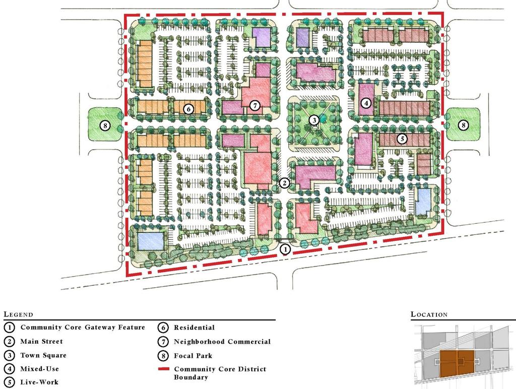
24 Level of Significance: Less-Than-Significant. Mitigation Measures: Not Applicable. Potential Impact: the site and its surroundings. Substantially degrade the existing visual character or quality of Impact Analysis: As seen in the preceding Figures and , the appearance of the Project site is dominated by dairy uses. The proposed alteration of the Project site from its current, largely agricultural state to the high-quality community of mixed-use neighborhoods envisioned under the Falloncrest Master Plan and Overall Design Concept (MPODC, included in Draft EIR Appendix B) will represent a noticeable change in baseline visual characteristics. Determinations of visual character and quality are inherently subjective by nature. As such, the proposed changes in aesthetic and visual characteristics of the Project area are qualitatively evaluated in this discussion. Visual changes that could result from Project development would be subject to development standards established under the, and by The Preserve Specific Plan. As discussed below, the Project incorporates site design and architectural elements that act to reduce its potential visual impacts and maintain views of off-site scenic resources. The MPODC has been created to be consistent with the overall development vision promulgated in The Preserve Master Plan. The MPODC provides the overall design concept for the Project s residential and commercial uses. Residential neighborhoods are planned to exhibit a cohesive yet varied mix of architectural styles and influences (MPODC, p. 37). Similarly, the design concept for commercial areas within the Project area reflects a main street feel, in all its diversity, contradiction and charm (MPODC, p. 52). Emphasis has been placed on creating an attractive pedestrian environment throughout the Project s commercial and residential neighborhoods. Aesthetics Draft EIR-SCH No Page
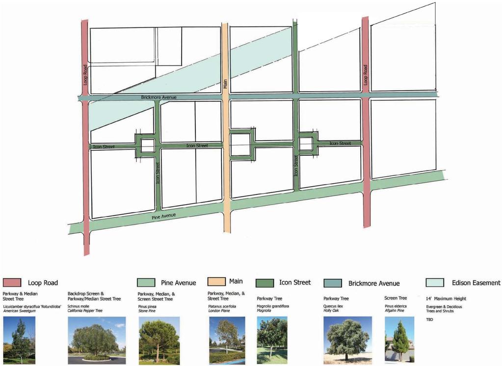
25 The following excerpt from the MPODC provides an overview of the Master Plan s vision for development, and its primary district and neighborhood design principles. Descriptive and representative illustrations from the MPODC have been incorporated in Figures through Falloncrest at the Preserve provides a balanced mix of retail, services, business, residential, recreational, and open space uses that will serve a broad range of family type, life-stage, and demographic needs. The neighborhood plan is comprised of a series of blocks connected through a traditional system of park-like streets and open space features. Each block, or parcel, includes a variety of home types focused around a centrally located park. The tree lined streetscapes form the backbone of the neighborhood and will establish a strong sense of character and unity within the neighborhood as well as the Preserve Core overall. Continuing to build upon the lessons learned in recently developed, traditional neighborhood design communities, the intent of Falloncrest is to emphasize the visual variety of the residential neighborhoods, generous parkways along the boulevard streets, and develop a consistent and harmonious theme and identity within the Falloncrest neighborhood. An integrated network of roadways, pedestrian ways, and open space features will unify Falloncrest as a community. (MPODC, p. 8) Aesthetics Draft EIR-SCH No Page

26
27


28 Source: Falloncrest at the Preserve Master Plan Figure Conceptual Street Views
29 The vision for Falloncrest includes an emphasis on creating a high quality, timeless neighborhood that improves over time. The goal is to create a neighborhood that emphasizes connectivity, neighborliness, and harmonious design. Minimize the visual impact of the garage door; Focus on the composition of building mass; Incorporate single story elements on multi-story buildings where appropriate; Create innovative plans, avoid repetitious designs, colors, elevations, and building footprints; Provide corner lot articulation and openness by developing corner lot floor plans, side-courts, and articulation; Narrow Streets; Street trees form a canopy; Variable lot setbacks; Architectural and site design that supports the street as a social space; Variety of compatible architectural styles; Emphasis on arcades, balconies, arbors, decks, porches, and covered terraces; and Varied yet consistent color palette. Landscaping will frame the perimeter of the Project area, with neighborhood landscaping that incorporates graceful tree-lined streets (MPODC, p. 63). Examples of planned parkway and recreational area landscaping are seen in Figures through Aesthetics Draft EIR-SCH No Page

30

31
32
33 In summary, the Project is consistent with the design standards of The Preserve Master Plan and is consistent with the findings of The Preserve Master Plan EIR. With implementation of the proposed Project, the visual character of the site will change to reflect the urbanizing pattern of the surrounding region. However, with implementation of the Project s design features, the Project s potential to substantially degrade the existing visual character or quality of the site and its surroundings is considered less-than-significant. Level of Significance: Less-Than-Significant. Mitigation Measures: Not Applicable. Potential Impact: Create a new source of substantial light or glare which would adversely affect day or nighttime views in the area. Impact Analysis: The Preserve Specific Plan provides lighting guidelines that are applicable to the Project. These guidelines require light standards and fixtures to conform to State and City safety and illumination requirements. In addition, these guidelines specify that the design and placement of onsite lighting is required to minimize glare affecting adjacent properties, buildings and roadways. The Preserve Master Plan EIR notes that although additional light and glare sources would be created, the use of landscaping, directional lighting criteria, and building design criteria incorporated into the specific plan would reduce the impact to a level that is less than significant. All lighting elements proposed by the Project in its final design stage are subject to review and approval by the City. Compliance with City standards, along with the development standards of The Preserve Specific Plan and the Falloncrest at The Preserve Master Plan will ensure that any potential light and glare impacts remain at a less-than-significant level and do not adversely impact surrounding areas. Aesthetics Draft EIR-SCH No Page
34 Level of Significance: Less-Than-Significant. Mitigation Measures: Not Applicable PROJECT IMPACTS COMPARED TO IMPACTS PREVIOUSLY IDENTIFIED UNDER THE CERTIFIED PRESERVE MASTER PLAN EIR As presented above, and consistent with the findings of The Preserve Master Plan EIR, aesthetics impacts of the are determined to be less-than-significant. Importantly, the Project would not cause or result in any new impacts beyond those already considered and addressed in The Preserve Master Plan EIR. Nor would the Project otherwise result in new significant and unavoidable aesthetics impacts that would not occur pursuant to The Preserve Master Plan. Table summarizes and compares aesthetics impacts and significance determinations for the proposed Project with the corollary impact and significance determinations for The Preserve Master Plan project previously approved by the City. Aesthetics Draft EIR-SCH No Page
35 Impact Have a substantial adverse effect on a scenic vista, or substantially damage scenic resources, including but not limited to trees, rock outcroppings, and historic buildings within a State scenic highway. Substantially degrade the existing visual character or quality of the site and its surroundings. Create a new source of substantial light or glare which would adversely affect day or nighttime views in the area. Table Comparison of Aesthetics Impacts Project and The Preserve Master Plan Falloncrest at The Preserve Master Plan Project EIR Significance Determination Less-thansignificant. The Preserve Master Plan EIR Significance Determination Less-thansignificant. Less-thansignificant. Less-thansignificant. Less-thansignificant. Less-thansignificant. Remarks No designated scenic vistas, scenic resources, or significant natural features have been identified within the vicinity of the Project site. No rock outcroppings or historic buildings are located onsite. Additionally, there are no officially designated scenic highways in the Project area. With implementation of the proposed Project, the visual character of the site will change to reflect the urbanizing pattern of the surrounding region. However, with implementation of the Project s design features, the Project s potential to substantially degrade the existing visual character or quality of the site and its surroundings is considered less-than-significant. Project compliance with City standards, along with the development standards of The Preserve Specific Plan and the Falloncrest at The Preserve Master Plan will ensure that any potential light and glare impacts remain at a less-thansignificant level and do not adversely impact surrounding areas. Sources: The Preserve Master Plan EIR Section 5.14, Aesthetics for Preserve Master Plan-related aesthetics impacts; remarks by Applied Planning, Inc. Aesthetics Draft EIR-SCH No Page
36 SUMMARY AND CONCLUSIONS Project impacts to aesthetics remain less-than-significant, as previously determined. In no instance would the Project create or result in significant aesthetics impacts not previously occurring under The Preserve Master Plan. In Certifying The Preserve Master Plan EIR, and adopting related Findings of Fact and Statements of Overriding Consideration, the City has previously acknowledged and disclosed The Preserve Master Plan s less-than-significant impacts to aesthetics. These Findings of Fact and Statements of Overriding Consideration reflect and address buildout of The Preserve Master Plan Area, inclusive of development that would be realized pursuant to buildout of the Falloncrest Master Plan Project. Aesthetics Draft EIR-SCH No Page
3.10 LAND USE SETTING PROJECT SITE EXISTING LAND USE DESIGNATIONS AND ZONING. General Plan Land Use Designations.
 This section of the Draft EIR addresses the existing land uses on and adjacent to the project site and discusses the potential impacts of the proposed project on existing land uses. Key issues addressed
4.1 AESTHETICS WATSON INDUSTRIAL PARK ENVIRONMENTAL IMPACT REPORT EXISTING CONDITIONS
 This Subsection describes the aesthetic qualities and visual resources present on the Project site and in the site s vicinity and evaluates the potential effects that the Project may have on these resources.
Nob Hill Pipeline Improvements Project EIR
 Section 3.1 Aesthetics This section addresses the visual aspects that may affect the views experienced by the public, including the potential to impact the existing character of each area that comprises
5. Environmental Analysis
 5.1 This section of the Draft Environmental Impact Report (DEIR) describes the existing landform and aesthetic character of the project area and discusses the potential impacts to the visual character
3.1 AESTHETICS Background and Methodology
 3.1 AESTHETICS 3.1.1 Background and Methodology 3.1.1.1 Regulatory Context The California Environmental Quality Act (CEQA) requires that project sponsors evaluate the project s potential to cause aesthetic
3.0 PROJECT DESCRIPTION
 3.0 PROJECT DESCRIPTION 3.1 BACKGROUND Under California law (Government Code Section 65300 et seq.), every city and county is required to have a general plan. The general plan is to be comprehensive and
CHAPTER 2 SUMMARY 1. PROJECT SUMMARY DATA
 CHAPTER 2 SUMMARY This is an Initial Study format used to determine, pursuant to CEQA Guidelines Section 15177, whether a project 1) is within the scope of a Master EIR (MEIR), 2) may result in additional
Prepared by: Casey Kempenaar, Senior Planner
 CITY OF CITRUS HEIGHTS PLANNING DIVISION STAFF REPORT PLANNING COMMISSION MEETING September 13, 2017 Prepared by: Casey Kempenaar, Senior Planner REQUEST The applicant requests a Design Review Permit Modification
6.8 SCENIC HIGHWAYS Introduction
 6.8 SCENIC HIGHWAYS 6.8.1 Introduction The Scenic Highways Element is an optional General Plan element authorized by Section 65303 of the Government Code. The Scenic Highways Element is intended to establish
4.1 LAND USE AND HOUSING
 4.1 This section provides a project-level analysis of potential impacts to land use, Shorelines of the State (shorelines), and housing. The study area for the land use and housing analysis in the Final
The impacts examined herein take into account two attributes of aesthetic values:
 IV. ENVIRONMENTAL IMPACT ANALYSIS This section addresses the potential impacts to views and aesthetics as a result of the proposed Project at the Project Site and the development scenarios analyzed for
4.1 Aesthetics Setting. a. Visual Character
 Environmental Impact Analysis Aesthetics 4.1 Aesthetics This section analyzes the proposed Specific Plan s impacts related to aesthetics, including the existing visual character of and scenic views in
TABLE OF CONTENTS. Tables Table UC Davis Park and Open Space Resources
 TABLE OF CONTENTS 4.13 Recreation... 4.13-1 4.13.1 Environmental Setting... 4.13-1 4.13.2 Impacts and Mitigation Measures... 4.13-4 4.13.3 References... 4.13-8 Tables Table 4.13-1 UC Davis Park and Open
SAN RAFAEL GENERAL PLAN 2040 INTRODUCTION AND OVERVIEW
 SAN RAFAEL GENERAL PLAN 2040 INTRODUCTION AND OVERVIEW Steering Committee Presentation February 14, 2018 Purpose of General Plan Guide land use and development decisions Coordinate transportation, infrastructure,
CHAPTER 10 AESTHETICS
 CHAPTER 10 AESTHETICS CHAPTER 10 AESTHETICS This section identifies and evaluates key visual resources in the project area to determine the degree of visual impact that would be attributable to the project.
I. STAFF POLICY RECOMMENDATIONS. The following RMP policy strategies are proposed by staff in support of a Scenic Resource Protection Program:
 Policy Consideration: Scenic Resource Protection Program Status: For Consideration by the Highlands Council at September 14, 2006 Work session Date: September 12, 2006 I. STAFF POLICY RECOMMENDATIONS The
3.1 Aesthetics, Light, and Glare
 3.1 3.1.1 Introduction This section describes the existing aesthetics, light, and glare setting and potential effects from project implementation on visual resources and the site and its surroundings.
Planning Commission Staff Report June 5, 2008
 Owner/Applicant Taylor Village Sacramento Investments Partners, LP c/o Kim Whitney 1792 Tribute Road #270 Sacramento, CA 95815 Staff Recommendation Planning Commission Staff Report Project: File: Request:
4.2 LAND USE AND AGRICULTURE PHYSICAL SETTING EXISTING LAND USES
 4.2 LAND USE AND AGRICULTURE This section provides an evaluation of the land-use compatibility and agricultural impacts of the proposed project (including the proposed off-site infrastructure improvements).
Silverlakes Equestrian Sports Park Draft Environmental Impact Report
 Silverlakes Equestrian Sports Park Draft Environmental Impact Report Aesthetics 4.1 - Aesthetics 4.1.1 - Introduction This section describes the existing aesthetic setting and potential effects from project
5.1 AESTHETICS, LIGHT, AND GLARE
 This section describes the existing aesthetic resources in the Project area and discusses potential impacts associated with implementation of the proposed Project. The analysis focuses on the anticipated
4. ENVIRONMENTAL IMPACT ANALYSIS 7. LAND USE AND PLANNING
 4. ENVIRONMENTAL IMPACT ANALYSIS 7. LAND USE AND PLANNING 4.7.1 INTRODUCTION The following analysis discusses the consistency of the Proposed Project with the corresponding land use and zoning designations
5.3 AGRICULTURAL & TIMBER RESOURCES
 5.3 AGRICULTURAL & TIMBER RESOURCES This section evaluates potential impacts caused by implementing the proposed Fortuna General Plan on: (1) the conversion of prime farmland to non-farmland use; (2) the
Environmental Setting, Impacts, and Mitigation Measures
 CHAPTER 3 Environmental Setting, Impacts, and Mitigation Measures Format of the Environmental Analysis The assessment of each environmental resource discussed in this chapter includes the following: Environmental
Chapter 6: Community Character
 Chapter 6: Community Character The term "community character" covers a broad spectrum of concerns. First and foremost, community character is a visual concept. In Long Grove, however, community character
DRAFT Amsterdam/Churchill Community Plan (4/17/08) Adopted By the Gallatin County Commission
 Adopted By the Gallatin County Commission") DRAFT Amsterdam/Churchill Community Plan (4/17/08) Adopted By the Gallatin County Commission Table of Contents Acknowledgements Chapter 1: Introduction A Brief History What s Next Authority Organization
DRAFT Amsterdam/Churchill Community Plan (4/17/08) Adopted By the Gallatin County Commission Table of Contents Acknowledgements Chapter 1: Introduction A Brief History What s Next Authority Organization
1 INTRODUCTION. A. Purpose of this General Plan
 1 How will Chino become a healthier place to live, work, and play? The City has established community health as a focus of this General Plan. Health touches all aspects of a community, from where residents
Visual and Aesthetics
 Such a connection could accommodate timed transfers and improve connections between local transit service and Presidio Shuttle service. Level of Service The results of the analysis are provided on a route-by-route
A. WHAT IS A GENERAL PLAN?
 I. Introduction A. WHAT IS A GENERAL PLAN? A general plan is the planning guideline for the future of a city. It contains goals and policies which regulate urban development, the protection of the natural
SECTION IV: DEVELOPMENT CONCEPT
 80 SECTION IV: DEVELOPMENT CONCEPT Section IV: DEVELOPMENT CONEPT This section provides an overall understanding and rationale for what is envisioned in The Preserve, the intended quality and character
DRAFT SCOPE FOR THE DRAFT ENVIRONMENTAL IMPACT STATEMENT FOR HUDSON HIGHLANDS RESERVE TOWN OF PHILIPSTOWN, NEW YORK June 5, 2018
 DRAFT SCOPE FOR THE DRAFT ENVIRONMENTAL IMPACT STATEMENT FOR HUDSON HIGHLANDS RESERVE TOWN OF PHILIPSTOWN, NEW YORK June 5, 2018 Project Name: Project Location SEQRA Classification of Project: Lead Agency:
-MENDOCINO COUNTY PLANNING AND BUILDING SERVICES- DIVISION II OF TITLE 20--COASTAL ZONING CODE
 CHAPTER 20.504 VISUAL RESOURCE AND SPECIAL TREATMENT AREAS Sec. 20.504.005 Applicability. Sec. 20.504.010 Purpose. Sec. 20.504.015 Highly Scenic Areas. Sec. 20.504.020 Special Communities and Neighborhoods.
Site Design (Table 2) Fact Sheet & Focus Questions:
 Fact Sheet & Focus Questions:") Site Design (Table 2) Fact Sheet & Focus Questions: BACKGROUND WHAT IS SITE DESIGN? Site design refers to the arrangement of buildings and open spaces on adjacent sites to maximize the shared benefits
Site Design (Table 2) Fact Sheet & Focus Questions: BACKGROUND WHAT IS SITE DESIGN? Site design refers to the arrangement of buildings and open spaces on adjacent sites to maximize the shared benefits
CHAPTER 4 COMMUNITY DEVELOPMENT AND DESIGN
 CHAPTER 4 COMMUNITY DEVELOPMENT AND DESIGN The Community Development and Design Chapter is extremely important because it, together with the Transportation and Circulation Chapter, provides the foundation
IV.B. VISUAL RESOURCES
 IV.B. VISUAL RESOURCES ENVIRONMENTAL SETTING Existing Visual Character Project Site The project site is located at 17331-17333 Tramonto Drive in the Pacific Palisades community of the City of Los Angeles
4.8 LAND USE AND PLANNING
 4.8 LAND USE AND PLANNING 4.8.1 INTRODUCTION This section describes existing and planned land uses at the Hayward campus and analyzes the impact of implementation of the proposed Master Plan on land uses
A Growing Community Rural Settlement Areas
 Town of Huntsville Official Plan Review - POLICY BACKGROUND PAPER A Growing Community Rural Settlement Areas BACKGROUND: In addition to the fully municipally-serviced Urban Settlement Area and the Hidden
5.1 AESTHETICS Environmental Setting Scenic Views FONTANA FORWARD GENERAL PLAN UPDATE DRAFT ENVIRONMENTAL IMPACT REPORT
 5.1 AESTHETICS This section describes the City s scenic resources, and landscape and neighborhood characteristics, and addresses the potential impacts on aesthetic and visual resources associated with
4.0 AFFECTED ENVIRONMENT AND ENVIRONMENTAL CONSEQUENCES
 4.0 AFFECTED ENVIRONMENT AND ENVIRONMENTAL CONSEQUENCES The following sections discuss the impacts associated with environmental resources for the tunneling method Alternatives A and B. The construction
DESIGN REVIEW COMMITTEE AGENDA ITEM
 DESIGN REVIEW COMMITTEE AGENDA ITEM AGENDA DATE: DECEMBER 16, 2015 TO: THRU: FROM: SUBJECT: Chair McCormick and Members of the Design Review Committee Leslie Aranda Roseberry, Planning Manager Kelly Christensen
EXECUTIVE SUMMARY DRAFT CHAPTER 1 INTRODUCTION EXECUTIVE SUMMARY
 CHAPTER 1 EXECUTIVE SUMMARY INTRODUCTION Through the joint efforts of the City of Tulsa planning staff and the Land Services division of Indian Nations Council of Governments (INCOG), the Berryhill Land
Staff Report and Recommendation
 Community Planning and Development Planning Services 201 W. Colfax Ave., Dept. 205 Denver, CO 80202 p: 720.865.2915 f: 720.865.3052 www.denvergov.org/cpd TO: City Council Neighborhoods and Planning Committee
Land Use element LAND USE POLICY AREAS ESTATE AND RURAL RESIDENTIAL AREAS/RURAL SHELDON AREA OLD TOWN ELK GROVE
 Land Use element Land Use is often considered the heart of the General Plan. The statement of future land uses describes how the City believes it should develop in the future where housing, shopping, open
4.1 AESTHETICS AND VISUAL QUALITY
 SCOPE AND METHODOLOGY 4.1 AESTHETICS AND VISUAL QUALITY This section evaluates the potential impacts to aesthetics and visual quality. Aesthetics refers to visual resources and the quality of what can
3.10 Land Use and Planning
 3.10 This section describes the regulatory and environmental setting for land use and planning in the program and individual project areas. It also describes impacts on land use and planning that could
Appendix E Section 4(f) Evaluation
 Evaluation") Appendix E Section 4(f) Evaluation Appendix E Draft Section 4(f) Evaluation E.1 Introduction This appendix addresses a federal regulation known as Section 4(f), which protects parks, recreation areas,
Appendix E Section 4(f) Evaluation Appendix E Draft Section 4(f) Evaluation E.1 Introduction This appendix addresses a federal regulation known as Section 4(f), which protects parks, recreation areas,
SECTION UNIFIED DEVELOPMENT ORDINANCE SECTION Part 1 Ordinance. ARTICLE 1 Zoning Districts
 SECTION 1-100 UNIFIED DEVELOPMENT ORDINANCE SECTION 1-300 Part 1 Ordinance SECTION 1-100. Introduction. ARTICLE 1 Zoning Districts Crystal Lake strives to maintain a balance of various land uses for a
Standards (R-3) Figure B-11: R-3 Residential Standards Exhibit
 Figure B-11: R-3 Residential Standards Exhibit") Avila Ranch Avila Ranch Specific Plan Development Standards High Medium Density - High Residential Density Residential Lot and Building Lot and Standards Building (R-3) Standards (R-3) EXAMPLES These sketches
Avila Ranch Avila Ranch Specific Plan Development Standards High Medium Density - High Residential Density Residential Lot and Building Lot and Standards Building (R-3) Standards (R-3) EXAMPLES These sketches
SUBJECT: Waterfront Hotel Planning Study Update TO: Planning and Development Committee FROM: Department of City Building. Recommendation: Purpose:
 Page 1 of Report PB-23-18 SUBJECT: Waterfront Hotel Planning Study Update TO: Planning and Development Committee FROM: Department of City Building Report Number: PB-23-18 Wards Affected: 2 File Numbers:
2. INTRODUCTION 2.1 AUTHORITY 2.2 PURPOSE AND INTENT 2.3 SITE LOCATION
 2. INTRODUCTION 2.1 AUTHORITY The City of Gardena initiated and prepared the Artesia Corridor Specific Plan pursuant to the provisions of California Government Code, Title 7, Division 1, Chapter 3, Article
EXHIBIT A. Tax Increment Reinvestment Zone No. 1 (Town Center) First Amended Project Plan 1
 First Amended Project Plan 1") EXHIBIT A Tax Increment Reinvestment Zone No. 1 (Town Center) First Amended Project Plan 1 1 As amended by Resolution No. 2008-02-001(TR1R) of the Tax Increment Reinvestment Zone No.1, and approved to
EXHIBIT A Tax Increment Reinvestment Zone No. 1 (Town Center) First Amended Project Plan 1 1 As amended by Resolution No. 2008-02-001(TR1R) of the Tax Increment Reinvestment Zone No.1, and approved to
hermitage town center
 hermitage town center A Community Vision prepared by Strada for The City of Hermitage and The Mercer County Regional Planning Commission January 2007 table of contents introduction 3 design principles
AWH REPORT OF THE PLANNING AND DEVELOPMENT DEPARTMENT FOR APPLICATION FOR REZONING ORDINANCE TO PLANNED UNIT DEVELOPMENT
 AWH REPORT OF THE PLANNING AND DEVELOPMENT DEPARTMENT FOR APPLICATION FOR REZONING ORDINANCE TO PLANNED UNIT DEVELOPMENT MAY 8, 2014 The Planning and Development Department hereby forwards to the Planning
Planned Development Review Revisions (Project No. PLNPCM )
") Planned Development Review Revisions (Project No. PLNPCM2014-00139) Standard residential development Planned Development Example: Smaller lot sizes than what is allowed to create open space amenity. What
Planned Development Review Revisions (Project No. PLNPCM2014-00139) Standard residential development Planned Development Example: Smaller lot sizes than what is allowed to create open space amenity. What
Policies and Code Intent Sections Related to Town Center
 Policies and Code Intent Sections Related to Town Center The Town Center Vision is scattered throughout the Comprehensive Plan, development code and the 1994 Town Center Plan. What follows are sections
3.1 AESTHETICS ENVIRONMENTAL SETTING VISUAL CHARACTER OF THE PROJECT SITE VISUAL CHARACTER OF THE SURROUNDING AREA
 3.1 AESTHETICS Aesthetic or visual resources are the natural and human-built features of the landscape that contribute to the public s appreciation and enjoyment of the aesthetic environment. This section
URBAN DESIGN GOALS / POLICIES / MEASURES
 URBAN DESIGN GOALS / POLICIES / MEASURES GOALS / POLICIES Authority Consideration of urban design issues in the general plan is provided under the Land Use Element requirements which direct attention to
Department of Community Development. Planning and Environmental Review Division Revised Notice of Preparation
 Department of Community Development Michael J. Penrose, Acting Director Divisions Building Permits & Inspection Code Enforcement County Engineering Economic Development & Marketing Planning & Environmental
~P'~'~; SAN FRANCISCO
 ~o counr~, ~P'~'~; SAN FRANCISCO ~'.~ PLANNING DEPARTMENT a 2 757 O~~~S 0 Case No.: Project Address: Zoning: Certificate of Determination COMMUNITY PLAN EVALUATION UMU (Urban Mixed Use) District 58-X Height
PC RESOLUTION NO
 PC RESOLUTION NO. 14-01-14-02 TENTATIVE TRACT MAP fttm) 17441. REZONE {RZ) 13-003, ARCHITECTURAL CONTROL (AC) 13-003, TREE REMOVAL PERMIT (TRP) 13-052. GRADING PLAN MODIFICATION (GPM) 13-002. CONDITIONAL
3.10 LAND USE AND AGRICULTURAL RESOURCES
 3.10 LAND USE AND AGRICULTURAL RESOURCES This section describes existing land uses, proposed land use designations, future potential development patterns, and evaluated land use impacts resulting from
ORDINANCE NO
 ATTACHMENT CC-1 ORDINANCE NO. 13-2113 AN ORDINANCE OF THE CUPERTINO CITY COUNCIL APPROVING THE REZONING OF AN APPROXIMATELY 1.1 ACRE AREA FROM PARK AND RECREATION (PR) TO PLANNED INDUSTRIAL PARK (P(MP))
12.0 LAND USE AND PLANNING
 This section describes the existing and proposed land uses and land use designations on each of the project sites and surrounding properties, and analyzes the potential for the project to conflict with
California Department of Transportation, California Scenic Highway Program; Placer Vineyards Specific Plan EIR prepared by Placer County;
 3.1 AESTHETICS 3.1.1 INTRODUCTION This section describes the visual character of the project site and views from surrounding public areas. This section also evaluates the change to visual resources in
PLANNING COMMISSION. Submitted
 PLANNING COMMISSION City Hall 1275 Main Street El Centro, CA 92243 Submitted PLANNING COMMISSION ACTION ITEM (1844) Meeting: 05/10/16 12:00 AM Department: Community Development Category: Public Hearing
THREE-STEP DESIGN PROCESS FOR OPEN SPACE SUBDIVISIONS
 00216106.DOC NMA/RRK 1/30/14 THREE-STEP DESIGN PROCESS FOR OPEN SPACE SUBDIVISIONS Open space subdivisions, sometimes called cluster developments, maintain a significant portion of a development site in
Baumgarten MPUD. Exhibit 3 Evaluation Criteria
 Pursuant to LDC subsections 10.02.13 B, 10.02.08 F and Chapter 3 G. of the Administrative Code, staff s analysis and recommendation to the Planning Commission, and the Planning Commission s recommendation
The transportation system in a community is an
 7 TRANSPORTATION The transportation system in a community is an important factor contributing to the quality of life of the residents. Without a sound transportation system to bring both goods and patrons
Staff Report CONDITIONAL USE
 Staff Report PLANNING DIVISION COMMUNITY & ECONOMIC DEVELOPMENT To: From: Salt Lake City Planning Commission Daniel Echeverria, (801) 535-7165, daniel.echeverria@slcgov.com Date: May 21, 2015 Re: PLNPCM2015-00139
ONTARIO MUNICIPAL BOARD
 PL 120483 ONTARIO MUNICIPAL BOARD Applicant/Appellant: 2124123 Ontario Limited Subject: OPA, Rezoning and Draft Plan of Subdivision Municipal Address: 3940 Highway 7 East Municipality: City of Markham
COMMUNITY DEVELOPMENT SERVICES PLANNING AND BUILDING DEPARTMENT PLACERVILLE OFFICE:
 COMMUNITY DEVELOPMENT SERVICES PLANNING AND BUILDING DEPARTMENT http://www.edcgov.us/devservices/ PLACERVILLE OFFICE: LAKE TAHOE OFFICE: 2850 Fair Lane Court, Placerville, CA 95667 924 B Emerald Bay Rd.
36.1. PURPOSE APPLICABILITY DESIGN REVIEW GUIDELINES
 CHAPTER 36: DESIGN STANDARDS 36.1. PURPOSE The purpose of this chapter is to ensure that projects are designed and constructed consistent with the Community Design Subelement of the Land Use Element and
Venice Pumping Plant Dual Force Main Project Draft EIR
 City of Los Angeles 5.9 LAND USE PLANS 5.9.1 Environmental Setting Venice Pumping Plant Dual Force Main Project Draft EIR The Project lies within the bounds of Los Angeles County and the City of Los Angeles.
3.0 Cumulative Scenario and Methodology. 3.0 Cumulative Scenario and Methodology
 3.0 Cumulative Scenario and Methodology Under the CEQA Guidelines, a cumulative impact consists of an impact which is created as a result of the combination of the project evaluated in the environmental
SUBJECT: PREDEVELOPMENT PLAN REVIEW OF PROJECT LOCATED AT 2632 EAST WASHINGTON BOULEVARD ('ST. LUKE MEDICAL CENTER')
") TO: FROM: Honorable Mayor and City Council Planning & Community Development Department SUBJECT: PREDEVELOPMENT PLAN REVIEW OF PROJECT LOCATED AT 2632 EAST WASHINGTON BOULEVARD ('ST. LUKE MEDICAL CENTER')
TO: FROM: Honorable Mayor and City Council Planning & Community Development Department SUBJECT: PREDEVELOPMENT PLAN REVIEW OF PROJECT LOCATED AT 2632 EAST WASHINGTON BOULEVARD ('ST. LUKE MEDICAL CENTER')
Land Use. Chapter 8: Introduction. Land Use Vision. Section I: Current Land Use 8-1
 Introduction Land use is the defining element of the comprehensive plan. It will serve as a framework for decision makers, guiding future growth and development in the Town of Oconto Falls. This chapter
SAN FRANCISCO PLANNING DEPARTMENT
 PLANNING DEPARTMENT Certificate of Determination EXEMPTION FROM ENVIRONMENTAL REVIEW Case No.: Project Address: Zoning: UMU (Urban Mixed Use) Zoning District 68-X Height and Bulk District Life Science
CHAPTER 4 FUTURE LAND USE AND URBAN SERVICES DISTRICTS
 CHAPTER 4 FUTURE LAND USE AND URBAN SERVICES DISTRICTS Introduction This chapter discusses how Benzie County should grow and change in the future. A community can grow and change in many different ways.
Rural Land Use Designations Kittitas County December 6, 2007 Draft
 KITTITAS COUNTY COMMUNITY DEVELOPMENT SERVICES 411 N. Ruby St., Suite 2, Ellensburg, WA 98926 CDS@CO.KITTITAS.WA.US Office (509) 962-7506 Fax (509) 962-7682 Rural Land Use Designations Kittitas County
5.9 LAND USE Existing Conditions Historic Land Use Trends Existing Land Use Distribution
 5.9 LAND USE This section describes the existing land use pattern and land use planning/regulatory framework in the City of Fontana. It also evaluates potential long-term land use impacts such as physically
SECTION 4 OPEN SPACE ELEMENT
 Open Space Element SECTION 4 OPEN SPACE ELEMENT c 4.1 INTRODUCTION 4.1.1 SCOPE OF ELEMENT The state requires every general plan to have an open space element Section 65302{e». The open space element must
Chapter 5: Recreation
 Chapter 5: Recreation Introduction and Setting Recreational opportunities within Nevada County are varied, ranging from public parks with intensively used active recreational facilities, to vast tracts
VILLAGE OF CLEMMONS PLANNING BOARD DRAFT STAFF REPORT
 VILLAGE OF CLEMMONS PLANNING BOARD DRAFT STAFF REPORT PETITION INFORMATION Docket # C-226 Staff Megan Ledbetter Petitioner(s) JBJH Properties, LLC Owner(s) JBJH Properties, LLC Subject Property 5892-49-1766
Glenborough at Easton Land Use Master Plan
 Land Use Framework November 30, 2007 2.0 LAND USE FRAME- WORK 2.1 LAND USE HISTORY and Setting Glenborough at Easton is located on property that was used for mining in the 19th and 20th centuries and rocket
SPECIFIC PLAN Requirements
 CITY OF LANCASTER PLANNING DEPARTMENT 44933 Fern Avenue, Lancaster, California 93534 (661) 723-6100 SPECIFIC PLAN Requirements Purpose The purpose of a specific plan is to provide for the logical development
Notice of Preparation and Notice of Public Scoping Meeting. At Dublin Project
 Notice of Preparation and Notice of Public Scoping Meeting Date January 17, 2018 To Project Title Project Application Number Project Location Project Applicant Contact For questions or submitting comments.
Planning & Zoning Commission Staff Report
 Planning & Zoning Commission Staff Report Meeting Date: May 26, 2015 Drafted by: Katherine Harrison-Rogers CASE # Z2886 PROJECT NAME: APPLICANT/ REPRESENTATIVE: Shawna Runyan PROPERTY OWNER: 1840 (previously
PLANNING COMMISSION AGENDA REPORT NOVEMBER 15, 2012
 PLANNING COMMISSION AGENDA REPORT NOVEMBER 15, 2012 TO: FROM: Members of the Planning Commission Michael Klein, Associate Planner FILE NO.: 120000890 PROPOSAL: APPLICANT: Request for an Administrative
Secrest Short Cut and Monroe Expressway Small Area Plan AUGUST 29, 2018
 Secrest Short Cut and Monroe Expressway Small Area Plan AUGUST 29, 2018 Background and Process Monroe Expressway will be open by the end of 2018 Union County and Indian Trail identified a need to revisit
DEPARTURE FROM DESIGN STANDARDS DDS-586
 The Maryland-National Capital Park and Planning Commission Prince George s County Planning Department Development Review Division 301-952-3530 Note: Staff reports can be accessed at www.mncppc.org/pgco/planning/plan.htm.
920 BAYSWATER AVENUE PROJECT
 920 BAYSWATER AVENUE PROJECT VISUAL ASSESSMENT Prepared for the City of Burlingame Prepared by Circlepoint 46 S First Street, San Jose, CA 95113 June 2018 This page intentionally left blank. 920 Bayswater
RESOLUTION NO: WHEREAS, the subject property has a Public, Semi-Public (PS) zoning designation and a General Plan designation of Institutional; and
 zoning designation and a General Plan designation of Institutional; and") RESOLUTION NO: A RESOLUTION OF THE CITY COUNCIL OF THE CITY OF PASADENA APPROVING A 14-YEAR, EIGHT-PHASE MASTER PLAN AMENDMENT FOR HUNTINGTON MEMORIAL HOSPITAL LOCATED AT 100 WEST CALIFORNIA BOULEVARD
RESOLUTION NO: A RESOLUTION OF THE CITY COUNCIL OF THE CITY OF PASADENA APPROVING A 14-YEAR, EIGHT-PHASE MASTER PLAN AMENDMENT FOR HUNTINGTON MEMORIAL HOSPITAL LOCATED AT 100 WEST CALIFORNIA BOULEVARD
DEVELOPMENT CONTROLS MEDICAL DISTRICT
 6.01. GENERAL DESIGN GUIDELINES A. Site Planning B. Architectural Design C. Medical Facility Signage & Lighting D. Exhibit 48. ARCHITECTURAL DESIGN CONCEPTS 6.02. MEDICAL FACILITY STANDARDS & GUIDELINES
ARLINGTON COUNTY, VIRGINIA
 ARLINGTON COUNTY, VIRGINIA County Board Agenda Item Meeting of April 12, 2014 DATE: April 2, 2014 SUBJECT: to the Arlington County Zoning Ordinance, Article 11.1 "CP-FBC" Columbia Pike Form Based Code
Introduction Environmental Setting. Visual Character. Surrounding Land Uses. Regional Setting. Project Site
 Contra Costa County Tassajara Parks Project Recirculated Draft EIR Aesthetics, Light, and Glare 3.1 - Aesthetics, Light, and Glare 3.1.1 - Introduction This section describes the existing aesthetics, light,
II. PROJECT DESCRIPTION
 II. PROJECT DESCRIPTION A. PROJECT APPLICANT The project applicant is the J.H. Snyder Company located at 5757 Wilshire Boulevard, Penthouse 20, in Los Angeles, CA 90036. B. PROJECT LOCATION The project
4.1 LAND USE, PLANS, AND POLICIES
 4.1 LAND USE, PLANS, AND POLICIES This chapter describes the existing land uses on the project site and the plans and policies applicable to the project, and evaluates the potential land use and planning
2.7 ac park. TOTAL 5,403 DU 1,297,900 sf 1,105,450 sf 3.87 ac 5,563 DU 1,121,200 sf 1,105,450 sf 3.87 ac
 PLAN AMENDMENT 2013-I-B1: SEVEN CORNERS SPECIAL STUDY Summary of Pre-staffing Comments Planner: Bernard Suchicital bsuchi@fairfaxcounty.gov (703) 324-1254 Background On October 29, 2013, the Board of Supervisors
CHAPTER FIVE COMMUNITY DESIGN
 CHAPTER FIVE COMMUNITY DESIGN CHAPTER FIVE - COMMUNITY DESIGN Assumptions Frazier Park and Lebec have historically developed according to different patterns of spatial form. While both communities are
Land Use Element. policy areas are discussed in this Element:
 Land Use Element Land Use is often considered the heart of the General Plan. The statement of future land uses describes how the City believes it should develop in the future where housing, shopping, open