South Atlantic Urban Conservation Summit: Thinking Megaregionally. Summary of September 21-22, 2016 Event
|
|
|
- Anastasia Lewis
- 5 years ago
- Views:
Transcription


1 South Atlantic Urban Conservation Summit: Thinking Megaregionally Summary of September 21-22, 2016 Event
2 Contents Background... 2 Interviews... 3 Interview Findings: Conservationists... 4 Interview Findings: Planners... 4 Interview Findings: Conclusion... 6 Summit... 7 Group Discussion... 7 Day 1: Current Work and Challenges... 7 Day 2: Priorities and Indicators... 8 Summary and Next Steps Appendix A. Interview Questions Questions for Conservation Professionals Questions for Planners Appendix B. Summit Meeting Agenda Appendix C. Summit Key Takeaways Individual Responses Appendix D. Current Conservation Blueprint Indicators Appendix E. Summit Attendees Appendix F. Glossary of Terms Background Urban communities are increasingly shaping the conservation future of the South Atlantic. The South Atlantic region, which spans from southern Virginia to northern Florida and west along the Piedmont plateau, is home to several of the fastest growing metropolitan areas in the country. Major metropolitan areas present both challenges and opportunities for conservation. The challenge of balancing natural and human uses of the area, particularly for natural greenways and corridors, mean that traditional approaches to green infrastructure and conservation are not adequate for urban areas. To address this, the South Atlantic Landscape Conservation Cooperative (South Atlantic LCC) has engaged the American Planning Association's Green Communities Center (APA) in a scoping project that is examining how large-scale, conservation-based green infrastructure definitions and urban scale definitions can be bridged in order to identify areas of shared conservation interest across the rural urban continuum. This project will offer improved ability to depict areas and actions of shared conservation interest near and within cities; improved corridor routing through and around municipalities; and improved relationships between urban planners and conservation professionals. 2


3 The first task of this project consists of identifying opportunities and challenges in the integration of local government green/blue infrastructure efforts with regional approaches like the Conservation Blueprint. This was accomplished through one-on-one interviews as well as an in-person summit of planners and conservation professionals. Interviews In August and September 2016, APA conducted interviews with 24 conservationists, planners, engineers, and parks professionals across the South Atlantic region to inform the Summit and help develop draft indicator ideas, with the goal of making the South Atlantic Blueprint a useful tool for local level planners. The interviews were conducted to gain a better understanding of how urban green infrastructure and conservation practices are prioritized and implemented within the South Atlantic and where challenges and opportunities exist for addressing shared conservation interests across scales. The complete interview guides can be found in Appendix A. Figure 2: Map of interview participants Figure 1: Breakdown of interview participants by professional role Conservationists Planners Stormwater engineers Parks & Rec 9 Planners Conservationists Others 3
4 Interview Findings: Conservationists APA spoke with conservation professionals who represent a range of federal, state, and nongovernmental organizations with different missions; however, they collectively work toward sustainability through their emphases on biological diversity, resiliency/adaptation, and protecting floodplains, wetlands, and/or endangered species and their habitats. The conservation professionals interviewed identified several strategies that they deemed to be the most effective options for either mitigating development in areas that are already built-out, or limiting development in areas where development had not yet occurred. They also identified approaches that were ineffective at advancing conservation goals. These included speaking to the choir, rather than expanding the reach of their message, as well as ignoring conservation in urbanized areas as a lost cause. Conservation professionals felt that mandates were much more effective than guidelines, but also emphasized that such mandates must be accompanied by incentives and/or education to have lasting impact. Figure 3: Most Effective Strategies for Addressing or Preventing Development Impacts (Conservationists) Effective Strategies to Mitigate Development Zoning Tax incentives Quality development (high density, good connectivity, conservation design) Multi-use conservation areas Showing the economic value of conservation Effective Strategies to Limit Development Land acquisition Conservation easements Public education to support zoning restrictions, taxes that fund conservation, and spending public funds on conservation Marketing/branding an area The interviewees discussed challenges they face in their work, which fell into two broad categories: coordination and education. Coordination was an obstacle due to a lack of regional links, unclear conservation objectives, and agencies and jurisdictions with overlapping areas of concern that fail to engage one another in their planning efforts. While educating developers and landowners was viewed as a vital activity, few conservation organizations had both the time and ability to engage these stakeholders. This was especially challenging in areas where there was little political appetite for conservation. Interview Findings: Planners In addition to the interviews with conservation professionals, APA talked with planners, stormwater engineers, and parks professionals engaging around green infrastructure and conservation at the local and regional levels. The interviewees work for local and regional planning agencies in North Carolina, South Carolina, Georgia, and Florida. Most of these planning agencies are using an integrated definition of green infrastructure in their work, looking from the site level to the regional scale at both conservation features and green stormwater infrastructure interventions. Many of the planning agencies have also mapped their green infrastructure networks or assets. However, what has been included in these mapped layers and how network elements are defined differs from agency to agency. 4
, flickr user loonyhiker (above).")

5 Figures 4 & 5: The 21-mile Swamp Rabbit Trail in Greenville, SC was given as an example of a successful and enduring public-private partnership. Image credit: flickr user ellyblue (left), flickr user loonyhiker (above). Interviewees highlighted several priorities associated with conservation, including water quality and stormwater management, as well as tree canopy preservation, sea level rise, and habitat protection. However, throughout the interviews, emphasis was placed on economic, quality of life, and livability benefits associated with green infrastructure and conservation activities. Local and regional planning agencies take different approaches and employ a range of tools to address conservation. Interviewees highlighted greenway plans and greenway systems as a means of addressing conservation that also has strong public support. Green infrastructure and conservation are also included in the goals and policies of local comprehensive plans and addressed through regulatory tools, including floodplain and tree ordinances, stormwater regulations, cluster/conservation subdivisions, and density bonuses. Local and regional agencies also provide technical assistance and direct financial assistance (often with partners). Direct financial assistance includes grant programs (such as Raleigh s Stormwater Quality Cost Share Program) and grants or rebates for rain barrels, rain gardens, or tree planting. Interviewees emphasized that they partner with a wide range of groups on a range of priorities and work with different groups on achieving different priorities. Partners include local land trusts, riverkeeper organizations, trail groups (e.g., the Carolina Thread Trail), local Universities and Extension programs, and state departments (e.g., Department of Natural Resources). Interviewees also discussed cross-departmental collaboration within their agencies. At the local level, departments including Public Works, Parks and Recreation, Transportation, GIS (a standalone department in some cases, a division in others), and Fire/Emergency Management were cited as frequently engaged around green infrastructure. Implementing green infrastructure and conservation activities is not without its challenges, and several key themes emerged from the interviews. These included location in an area of the country that has strong private property rights combined with high population growth that poses significant 5
6 development pressure. They also included availability of funding to implement planned-for projects and the lack of capacity in small towns and rural communities throughout the region. Finally, interviewees identified lack of both political will and general awareness and understanding (among both the public and elected officials). While interviewees identified several challenges, they also had recommendations for achieving conservation and green infrastructure goals. These included focusing the conversation on things that the community values and that resonate with community members and local elected officials, including economic benefits, livability and quality of life concerns, and recreation opportunities. They also included starting small, such as with a pilot project, to build support and momentum, and finding advocates both within and without local government. Figure 6: Identified Challenges to Implementing Conservation Activities (Planners) Development pressures from being in a high-growth region Availability of funding Private property rights Political will Lack of capacity in small/rural communities General awareness/understanding Interview Findings: Conclusion The interviews with conservation professionals and planners highlighted that conservation and green infrastructure are approached from different perspectives. For conservation professionals, sustainability, the protection of habitat, floodplains, and wetlands, and the resiliency functions of natural landscapes are the central drivers of conservation actions. For planners, the conversation around conservation and green infrastructure is often driven more by community concerns, such as economic benefits, community quality of life, and recreation opportunities. As a result, a multi-benefit approach to conservation and green infrastructure is key to advancing these goals. There are many competing priorities at the local and regional levels, and focusing on the multiple benefits of green infrastructure approaches can show how those approaches connect to other community goals and priorities and can be a tool for achieving those goals. One key difference between the two groups was their feelings on the effectiveness of government mandates for conservation. Conservation professionals noted that regulatory approaches are important and often fundamental to successful conservation. However, planners noted that, while local agencies use regulatory approaches, many of them are in a geographical area with strong private property rights. For those planners, education and incentives were viewed as being more successful than regulation, which is often opposed by both landowners and elected officials. Additionally, there is a need for increased funding to support green infrastructure and conservation. Conservationists cited land acquisition as one of the most effective strategies. Planners noted that often when there is funding for a program, local governments will engage around an issue. However, when the funding source ends, the issue becomes a lower priority. Both point to the need for more sustained funding sources for conservation and green infrastructure. Identifying metrics can also be a challenge and interviewees cited few specific indicators or metrics. Instead, they broadly expressed that implementing projects and increasing public support can be viewed as metrics of success. 6

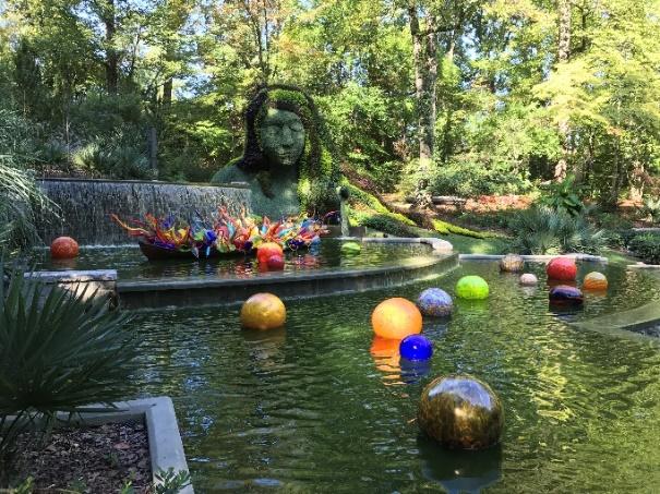
7 Summit Following the interviews, on September 21-22, 2016, 25 urban planners and conservation professionals representing 17 organizations throughout the South Atlantic joined together at the Atlanta Botanical Garden to discuss their shared missions, issues, and opportunities for collaboration. The full agenda for this Urban Conservation Summit can be found in Appendix B. Group Discussion Day 1: Current Work and Challenges Figure 7: Summit participants broke into small groups for On the first day of the summit, attendees addressed discussions at the Atlanta Botanical Garden s Georgia Pacific Classroom. Image credit: Hilary Morris, South Atlantic LCC. questions related to what planners are (or should be) working on in relation to conservation, as well as challenges and barriers to that type of work. Attendees summarized their key takeaways from this discussion, which can be found in Appendix C. What are planners working on related to natural resource conservation? Or, what should they be working on? Planners indicated that they are working on issues related to water quality and greenways, generally at the local scale. Habitat issues on a clustered/regional/landscape scale was identified as an area where planners should be playing a larger role. Many planners address conservation as it relates to other issues that resonate more with the public, such as aesthetics. What are the challenges and barriers to incorporating natural resources into planning? Conservation often suffers from the perception that it is in direct opposition to economic development and as a result may not be a priority at the local level. Community engagement and communication across disciplines (not just conservation and planning) can help elevate conservation in the conversation. More education is needed at the local and regional levels, including for elected officials, developers, and property owners. Local government capacity in terms of both staffing and funding can limit planners involvement in conservation efforts, but collaborating on larger scales and across multiple jurisdictions could result in operational efficiencies. Conservationists often face the challenge of when to become involved in the planning process, and where planners and conservationists can best collaborate. Conservationists noted that it would be helpful to have a better understanding at the points in a comprehensive planning process, zoning code update, or other planning process where their involvement would be the most impactful. 7

8 Also, when looking beyond the region, it is important to recognize that not all areas of the country are in the same high-growth mode or facing the same development pressure as the South Atlantic. Values may differ in areas such as the Midwest or Northeast, and it is important to recognize the variety of perspectives among different communities. Day 2: Priorities and Indicators On Day 2, attendees discussed how conservation priorities are set, opportunities for collaboration, and possible conservation indicators. How do planners set priorities for conservation action? At the local level, the comprehensive planning process is the primary process through which planners prioritize activities, including conservation action. An abundance of data and investigative work goes into these plans, such as inventories of natural features and, in Florida, the Critical Lands and Waters Identification Project. The challenge becomes how to implement what are often lofty goals. How do conservation planners set priorities for conservation action? Conservation professionals tend to set priorities based on the region in which they are working and the specific charge of their organization. For some areas, overall goals are for the persistence of ecosystem integrity, whereas in other areas it might be a priority on an identified species assemblage, such as the longleaf pine ecosystem. Information and science are key to establishing these priorities, but it is also important to understand what the community wants. This is particularly important at the site-level scale where implementing a park or greenway that impacts people on the ground. Where are there opportunities for collaboration and integration? Different entities can play different roles. Non-governmental organizations (NGOs) typically are nimbler than government and thus may be able to step in where government entities can t; however, there is a chance that they will come in with their own agendas. NGOs can also play a role in bridging the planning and conservation worlds. These groups can also partner with each other, as well as with local and regional agencies, in seeking national funding sources. APA s Five Strategic Points of Intervention in the continuum of urban planning activities, from plan development to implementation, could be used as a potential framework for conservationists and planners to work together to advance conservation priorities. These are: 1. Long-range community visioning and goal setting; 2. Plan making; 3. Standards, policies, and incentives; Figure 8: Anna Read of APA presents a summary of her interviews with planners in the South Atlantic region. Image credit: Jennifer Henaghan, APA. 8
.")
9 4. Development work; and 5. Public investments. Current trends that overlap both fields and connect to conservation and green infrastructure priorities include ecotourism and urban agriculture. Indicators The Conservation Blueprint is based upon 28 measures of ecosystem health, including species, habitats, and abiotic factors (see specific indicators in Appendix D). These indicators were developed with input from more than 240 experts in marine, freshwater, and terrestrial resources in the South Atlantic region and all five adjacent LCCs. The indicators can be modeled using existing data and allow the South Atlantic LCC to track progress toward ecosystem goals. They were chosen to reflect the goals of ecological integrity and intact cultural landscapes, using the following criteria: 1. Ecological: indicators must represent a variety of other organisms or ecological attributes and respond to landscape change. 2. Practical: we must be able to monitor and model indicators based on current programs and resources. 3. Social: indicators receive extra consideration if they resonate with a variety of audiences. Summit attendees discussed what indicators could be modeled to improve the Blueprint s effectiveness within urban areas. In general, most agreed that although there is a large amount of conservation data available, not much is currently incorporated into indicators to measure progress towards achieving goals (with the Blueprint being an exception). Several participants expressed the idea that indicators can be difficult, as they don t always tell the true story. For example, cultural differences dictate how people Figure 9: Conservation Blueprint 2.1, from 9
10 use parks and waterways. For this reason, qualitative measures can sometimes be more effective than quantitative metrics in helping to understand the nature of the problem at hand. Since every community has its own values, indicators can provide greater value when they are established at the community level based on local conditions. Participants suggested a range of potential indicator topics under the triple bottom line of sustainability (environmental, economic, and social benefits). Environmental topics included water quality, pollinators, tree canopy density, invasive species removal, and stormwater and bioretention capacity. Suggestions for economic indicators included employment, income, and economic outlook/performance (e.g., household expenditures). Attendees had a wide variety of ideas for indicator topics that reflect social benefits, such as the number of people reached or engaged (e.g., students near a park, people attending science festivals, voter turnout), access to parks within walking distance or parks per capita, and looking at the number of female bicyclists to measure bicycle friendliness. Quality of life was another topic of interest, from looking at happiness indices to specific measures of health criteria (e.g., number of asthma cases, access to healthy food). Summary and Next Steps Some of the common themes that emerged from the discussion recognized that conservation professionals and planners are both designing landscapes at different scales, so we need to design together. Planners can help conservation professionals identify science needs and implement science in a way that creates effective and beautiful urban conservation solutions. However, there is a need to developing a shared vocabulary and improve effective communication both between conservation and planning professionals and with elected officials. Values centered around wildlife, habitat, and ecological integrity can be translated to the commonly stated values of communities such as economic development, quality of life, clean and plentiful water. In working together in furtherance of these values, we must be careful not to lose sight of equity. Urban conservation provides an opportunity to help underserved communities, which requires that we listen and foster participation to empower communities to create solutions that address their needs. At the summit, participants began compiling a glossary of definitions to help establish a common language to overcome communication barriers between conservation professionals and the planning sector (which can be found in Appendix F). Participants further agreed to work on a guidance document for conservation professionals to become more familiar with urban planning processes and engagement opportunities. Both documents will be drawn upon by the South Atlantic LCC and APA as they work together over the next year to develop and implement an improved approach to the Blueprint design near and within cities, including improvements to the urban open space indicator and related ecosystem indicators. 10
11 Appendix A. Interview Questions Questions for Conservation Professionals 1. How would you assess your involvement in urban conservation issues, with 10 being very extensive and 1 being not really involved at all? 2. (If not covered in Question #1) How are you involved in urban conservation? Please describe. 3. What are your primary urban conservation goals? 4. What local government departments (e.g., planning, public works, engineering, parks) or other partners (consulting firms, etc.) do you typically work with on urban conservation issues? 5. Which of the following do the communities you work with use to address conservation: a) Comprehensive Plan b) Functional Plans (e.g., Parks and Open Space, Green Infrastructure) c) Regulatory Tools (e.g., zoning ordinance, floodplain ordinance, subdivision regulations) d) Programs or incentives (e.g., Backyard Habitats) e) Anything else you d like to mention about how the communities you work with address conservation? 6. How do you measure the success of your urban conservation efforts? Are there any particular indicators that work well? 7. How do you prioritize your urban conservation activities? 8. Have you worked on a multi-jurisdictional or regional conservation planning effort? If yes, please describe. 9. Have you participated in developing a local green infrastructure vision, inventory, or prioritization exercise? If yes, please describe. a) If yes, how is green infrastructure defined? 10. Have you participated in developing a regional green infrastructure vision, inventory, or prioritization exercise? If yes, please describe. a) If yes, how is green infrastructure defined? 11
12 11. If yes to 7 and 8, please describe how local and regional visions/inventories/prioritizations connect. 12. What have been the most significant challenges in implementing urban conservation projects, and how were they overcome? 13. In your opinion, what are the most effective strategies for dealing with conservation in areas that have already developed with housing and businesses? 14. In your opinion, what are the least effective strategies for dealing with conservation in areas that have already developed with housing and businesses? 15. In your opinion, what are the most effective strategies to prevent or limit housing and businesses in high-priority conservation areas that have not yet developed? 16. Assuming that construction of housing and businesses will occur in undeveloped high-priority conservation areas, what are the best strategies to mitigate the conservation impacts of housing and businesses that may locate there in the future? 17. In your opinion, what communities are doing the best job in planning for conservation? 18. Is there one project or success story in particular that you re most proud of? 19. Can you share any photographs or illustrations of urban conservation or green infrastructure projects that you ve worked on)? 20. Is there any other information you would like to share? Questions for Planners 1. How would you assess your jurisdiction s involvement in conservation issues, with 10 being very extensive and 1 being not really involved at all? 2. What are the primary conservation goals for your jurisdiction (e.g., wetlands, urban open space, water quality, greenways)? 3. What local government departments (e.g., planning, public works, engineering, parks) are most involved in conservation efforts in your community? 4. Which of the following does your jurisdiction use to address conservation? a) Comprehensive Plan b) Functional Plans (e.g., Parks and Open Space, Green Infrastructure) 12
13 c) Regulatory Tools (e.g., zoning ordinance, floodplain ordinance, subdivision regulations) d) Programs or incentives (e.g., Backyard Habitats) e) Anything else you d like to mention about how your jurisdiction addresses conservation? 5. How does your jurisdiction measure the success of conservation programs? Are there any particular indicators that work well? 6. How does your jurisdiction prioritize conservation activities? 7. What individuals or organizations do you typically consult with on conservation issues (e.g., land trusts, academics, state or federal agencies)? 8. Has your jurisdiction worked with neighboring jurisdictions or a regional entity on conservation planning efforts? If yes, please describe. 9. Has your jurisdiction completed a local green infrastructure vision, inventory, or prioritization exercise? If yes, please describe. a) If yes, how is green infrastructure defined? 10. Has your jurisdiction participated in a regional green infrastructure vision, inventory, or prioritization exercise? If yes, please describe. a) If yes, how is green infrastructure defined? 11. If yes to 7 and 8, please describe how local and regional visions/inventories/prioritizations connect. 12. What challenges or barriers do you see related to conservation and/or green infrastructure in your jurisdiction? If not addressed in response, to long-term maintenance/protection/sustainability? 13. What strategies has your jurisdiction found to be effective for building community support for conservation related activities? Green infrastructure? 14. Is there one project or success story in particular that you re most proud of? 15. Can you share any photographs or illustrations of conservation or green infrastructure projects in your jurisdiction? 16. Is there any other information you would like to share? 13
14 Appendix B. Summit Meeting Agenda Day 1 Wednesday, September 21 1:00 p.m.-1:45 p.m. Introductions and icebreakers 1:45 p.m.-2:45 p.m. Overview and report on interviews 2:45 p.m.-3:15 p.m. Break 3:15 p.m.-4:15 p.m. Breakout groups What planners are working on related to natural resource conservation Challenges and barriers to incorporating natural resources into planning 4:15 p.m.-4:45 p.m. Reconvene and report out 6:30 p.m. Group dinner at The Flying Biscuit, 1001 Piedmont Ave NE, Atlanta, GA Day 2 Thursday, September 22 9:00 a.m.-10:00 a.m. Day 1 summary and group discussion 10:00 a.m.-10:30 a.m. Break 10:30 a.m.-11:30 a.m. Breakout groups Setting priorities for conservation action Opportunities for collaboration and integration 11:30 a.m.-12:00 p.m. - Reconvene and report out 12:00 p.m.-1:00 p.m. Lunch (on site) 1:00 p.m.-2:00 p.m. Measuring success 2:00 p.m.-2:30 p.m. Wrap up and next steps 14
15 Appendix C. Summit Key Takeaways Individual Responses How can conservation planning and regional planning be integrated? How does equity become a guiding principle in these conversations? Conservation professionals could provide planners with science to advance urban conservation and justify it for decision makers. How do planners and conservationists talk about land that isn t built upon? The categorization of such land as vacant or undeveloped implies that it doesn t have any value. We need to figure out how to turn data into something tangible and visually pleasing. There needs to be more communication and exchange of information between conservationists and planners to identify land acquisition areas and issues, including management and funding. Focus on how planners and urban conservationists can drive equitable outcomes. Conservation professionals need to do a better job translating their values into the values of communities. (For example, wildlife/habitat/ecological integrity leads to economic development, quality of life, and clean/plentiful water.) Both the planning community and the conservation community are designing landscapes (in the large sense). We need to design together to ensure sustainability for humans and nature. A strategy that articulates, quantifies, and adapts conservation values for the planning profession is needed. Regarding conservation action at a local level, it is crucial to understand the motivating values of parties/groups/constituencies. We need to hear from all parties interested in deciding an issue. Focus on incorporating conservation priorities into other aspects of urbanization (i.e., infrastructure, housing, economic development, public health). There are increasing opportunities to work on communicating the values of natural resources in new and creative ways. Planners and conservationists aren t so different. We face a lot of the same problems and now we as a group are tasked with drilling into those issues and figuring out how we can work on them together. We need to have a strategic approach for investment and not make shotgun decisions. We can find relevancy with key audiences based on values (aesthetics, etc.). Values, audience, engagement are critical factors. 15
16 We need to focus the conversation on how better science/data/metrics can drive policy on the federal/state level to implement local planning and actions to meet contemporary conservation needs. Conservationists and planners cam move toward closer collaboration by incorporating each other s central values and developing shared visions for communities at multiple scales. A guidance document is needed to help biologists understand development/land use planning and the players/roles (including consultants) in relation to conservation opportunities. The thing that stood out to me (about the Summit) was the difference in values between the public/government and the planners/conservation professionals. It sounded like the public is responding to aesthetics while both planners and conservation professionals are thinking about all these specific needs (stormwater management, transportation, wildlife, science). There are parts of the public that planners/conservationists are better at communicating with. There is a need to develop a common vocabulary sometimes the same terms are used differently. This is important not only to communicating across fields but also with elected officials and the public. There is a need for better communication from all sides so that all parties are on the same page. With that comes the types of information we communicate: visual, scientific, social, economic. All need to link and be related. 16

 Unaltered beach: index of impacts from")


 Forested wetland amphibians: Priority")


: index of sites on the")
17 Appendix D. Current Conservation Blueprint Indicators Beach & dune Beach birds: index of habitat suitability for 4 shorebird species (Wilson s plover, American oystercatcher, least tern, piping plover) Unaltered beach: index of impacts from hardened structures like jetties, groins, and infrastructure Estuarine Coastal condition: index of water quality, sediment quality, and benthic community condition Wetland patch size: index based on the size of wetland patches Water-vegetation edge: index of length of edge between open water and vegetation Forested wetland Forested wetland extent: overall acres of forested wetlands Forested wetland birds: index of habitat suitability for 6 bird species (Northern parula, black-throated green warbler, red-headed woodpecker, Chuck-will s widow, prothonotary warbler, Swainson s warbler) Forested wetland amphibians: Priority Amphibian and Reptile Conservation Areas (PARCAs) within forested wetlands Freshwater aquatic Riparian buffers: percent natural habitat near rivers and streams Permeable surface: percent non-impervious cover by catchment Imperiled aquatic species: number of rare aquatic species within each watershed Landscapes Structural connectivity: important hubs and corridors for ecological connectivity Low road density: index of areas with few roads Resilient biodiversity hotspots: index of mostly natural high-diversity areas potentially resilient to climate change Low-urban historic landscapes (cultural indicator): index of sites on the National Register of Historic Places surrounded by limited urban development Marine Marine mammals: index of highly productive areas for dolphins and whales 17


 Regularly burned habitat: acres of fire-maintained, open")
: overall acres of")


: index based on distance of urban")

18 Potential hardbottom condition: index of potential condition of deepwater corals and other hardbottom habitats Maritime forest Maritime forest extent: overall acres of maritime forest Pine, woodland, savanna & prairie Pine and prairie birds: index of habitat suitability for 3 bird species (Northern bobwhite, red-cockaded woodpecker, Bachman s sparrow) Regularly burned habitat: acres of fire-maintained, open canopy habitat Pine and prairie amphibians: PARCAs within pine and prairie Longleaf pine extent (cultural indicator): overall acres of longleaf pine Freshwater marsh Freshwater marsh birds: index of habitat suitability for 4 freshwater marsh bird species (least bittern, Northern pintail, Northern shoveler, king rail) Freshwater marsh extent: overall acres of freshwater marsh Upland hardwood Upland hardwood birds: index of habitat suitability for 7 upland hardwood bird species (wood thrush, whip-poor-will, hooded warbler, American woodcock, Acadian flycatcher, Kentucky warbler, Swainson s warbler) Urban open space (cultural indicator): index based on distance of urban areas from open space Waterscapes Network complexity: number of connected stream classes in a river network Migratory fish connectivity: how far upstream different migratory fish species have been observed 18
19 Appendix E. Summit Attendees Adam Terando Southeast Climate Science Center Raleigh, NC Allison Duncan Atlanta Regional Commission Atlanta, GA ma Amy Keister South Atlantic LCC Raleigh, NC Anna Read American Planning Association Washington, DC Bill Uihlein US Fish & Wildlife Service Atlanta, GA Chris Faulkner Atlanta Regional Commission Atlanta, GA Dan Calvert Dept. of Parks, Recreation, & Cultural Affairs Atlanta, GA David Rouse American Planning Association Washington, DC Greg Wathen Gulf Coastal Plains & Ozarks LLC Nashville, TN Hilary Morris South Atlantic LCC Raleigh, NC Jennifer Henaghan American Planning Association Chicago, IL Jenny Cruse-Saunders Atlanta Botanical Gardens Atlanta, GA Kacy Cook NC Wildlife Resources Commission Star, NC Karl Schrass National Wildlife Federation Annapolis, MD Kristin Shaw Ecological Places in Cities Bloomington, IN Mallory Martin South Atlantic LCC Raleigh, NC 19
20 Marilyn Hall Athens-Clarke County Unified Government Athens, GA Myriam Dormer The Nature Conservancy Atlanta, GA Rick Jones City of Columbus Planning Dept Columbus, GA Rua Mordecai South Atlantic LCC Raleigh, NC Shanice Jones Florida State University Tallahassee, FL Shannon Lee The Conservation Fund Atlanta, GA Stacy Funderburke The Conservation Fund Atlanta, GA Stephen Hodges City of Tallahassee Tallahassee, FL Sara Gottlieb The Nature Conservancy Atlanta, GA 20
21 Appendix F. Glossary of Terms 303(d) Adaptive management AICP APA Block perimeter standard BMP Comprehensive plan Section 303(d) of the Clean Water Act requires states to submit lists of their impaired waters (those that are too polluted or otherwise degraded to meet drinking standards), prioritize them, and determine Total Maximum Daily Loads for these waters. Anticipatory government aimed at improving resource management by learning from management outcomes. American Institute of Certified Planners. The professional institute of the American Planning Association and has responsibilities for accreditation (through the Planning Accreditation Board), certification, professional standards, and Certification Maintenance. American Planning Association. The national membership organization for urban planners. It provides leadership in the development of vital communities by advocating excellence in planning, promoting education and citizen empowerment, and providing members with the tools and support necessary to meet the challenges of growth and change. Restrictions on the size of a block, used to regulate street connectivity. Best Management Practices. Activities, prohibitions, practices, procedures, programs, or other measures designed to prevent or reduce the discharge of pollutants directly or indirectly into waters of the United States. The comprehensive plan, which may also be referred to as the general plan or the master plan, is the foundational policy document for local governments; it establishes a framework to guide public and private decisions about future growth, preservation, and change within the community over the long term, frequently 20 to 30 years. Conservation Blueprint Conservation development Conservation v. restoration CSO A cross-boundary, cross-organization plan that prioritizes areas for shared conservation action in the South Atlantic. Subdivision or other development that sets aside a majority or large percentage of land as open space or other conservation area. Keeping land in its existing natural condition v. constructing a natural area or bringing it back to a past natural state. Combined sewer overflow. Combined sewer systems are sewers that are designed to collect rainwater runoff, domestic sewage, and industrial wastewater in the same pipe. Most of the time, combined sewer systems transport their wastewater to a sewage treatment plant, where it is treated and then discharged to a water body. During periods of 21
22 Dillon's rule Down-zoning Ecosystem services Euclidean zoning Form-based zoning Green infrastructure HOA Home rule LCC LCD heavy rainfall or snowmelt, however, the wastewater volume in a combined sewer system can exceed the capacity of the sewer system or treatment plant, in which case they discharge CSO containing excess wastewater directly to nearby streams, rivers, or other water bodies. Municipalities have only those powers that are expressly granted to them by the state. (Compare to home rule.) The process of reducing the allowable density of development on a lot. The various resources and processes that natural resources can supply to human settlements. Traditional zoning scheme in which uses are segregated into distinct districts such as residential, commercial, and industrial. (Compare to form-based zoning.) Zoning scheme where districts dictate the physical appearance (height, setbacks, etc.) of buildings but do not generally prescribe specific land uses. The network of green spaces, including natural areas, open space, and constructed or managed solutions to stormwater management, linked across the natural and built environment, which provide habitat, ecosystem services, and associated benefits to human populations. Homeowners Association. An incorporated nonprofit organization operating under recorded land agreements through which each lot owner is automatically a member and each lot is automatically subject to a proportionate share of the expenses for the organization s activities, such as maintaining common property. Municipalities have the authority to pass laws or ordinances, provided they do not conflict with State or Federal law. (Compare to Dillon's rule.) Landscape Conservation Cooperative. Self-directed partnerships between federal agencies, states, tribes, non-governmental organizations, universities, and other entities to collaboratively define science needs and jointly address broad-scale conservation issues within a defined geographic area. There are 22 LCCs within North America, the Pacific Islands, and the Caribbean. Landscape Conservation Design. Planning process that involves combining geospatial data with biological information and models to create tools such as maps that evaluate the potential of every acre of habitat to support a species population. 22
23 Low-impact development LRTP Megaregion/megalopolis MPO NGO O&M Open standards for the practice of conservation PDR RPC A subset of green infrastructure that uses natural approaches or mimics natural approaches to managing stormwater in developed areas. Long-Range Transportation Plan. That portion of a comprehensive plan indicating the general location recommended for expressway, arterial, collector, and local thoroughfares as well as transit, pedestrian, and bicycling facilities and policies. Networks of metropolitan areas that share economic, environmental, and cultural features, as well as infrastructure and geographic connections. (e.g., the Piedmont Atlantic megaregion, which incorporates portions of six states). Megaregions have no legal status or official governance mechanisms in the U.S. Metropolitan Planning Organization. A federally-mandated and federally-funded transportation policy organization required in urbanized areas with a population of more than 50,000 by the Federal Aid Highway Act of MPOs were created by Congress to ensure that the expenditures of federal funds are made within a continuing, cooperative, and comprehensive planning process. MPOs may be independent or housed within a Regional Planning Commission or Council. Non-Governmental Organization. Any non-profit, voluntary group which is organized on a local, national or international level. Operations and Maintenance. Within government, an operations and maintenance function is typically found within a public works department and is charged with managing government-owned infrastructure and properties, including infrastructure and utilities. Principles and best practices to assess the effectiveness of conservation actions, developed by the Conservation Measures Partnership. Purchase of Development Rights. PDR programs allow property owners to receive financial compensation in exchange for a portion of the development rights that they would otherwise be afforded under the local zoning regulations. A restrictive easement is placed upon the subject property that permanently restricts development on the land. (Compare to PDR.) Regional Planning Commission or Regional Planning Council. A governmental or quasi-governmental agency that performs planning for land development for an area encompassing land in more than one county. 23
24 SECAS Stewardship TDR TMDL UDO Vacant WQS Southeast Conservation Adaptation Strategy. The Southeast Conservation Adaptation Strategy (SECAS) is a shared, long-term vision for lands and waters that sustain fish and wildlife populations and improve human quality of life across the southeastern United States and Caribbean. The ongoing care and management of land or other resources. Transfer of Development Rights. TDR programs transfer the development rights of a property known as a sending area to another property, known as the receiving area. Thus, while the development rights are reduced or severed on the sending area, increased density and development is allowed on the receiving area. (Compare to PDR.) Total Maximum Daily Load. A calculation of the maximum amount of a pollutant that can be present in a water body and still meet water quality standards. Unified Development Ordinance. Also called a unified development code, this is a legally adopted document that combines traditional zoning and subdivision regulations within a single document. May also include regulations pertaining to stormwater management, design, and/or signage. Land that is "unused." May be used for future development, and/or may provide a valuable habitat or other ecosystem function in its undeveloped state. Water Quality Standard. Clean Water Act requirement to designate the use of bodies of water and establish criteria to protect and maintain them. 24
But What About the People? The Role of Urban Planning and Green Infrastructure
 But What About the People? The Role of Urban Planning and Green Infrastructure The Southeast Conservation Adaptation Strategy: A Model for Collaborative Conservation David Rouse, FAICP, ASLA Managing Director,
2014 South Atlantic LCC
 2014 South Atlantic LCC Annual Report 1 Allie Stewart, U.S. FWS The South Atlantic LCC s 2014 Annual Report this year of progress and accomplishments is dedicated to South Atlantic LCC Coordinator, Ken
STEWARDSHIP OF LONG ISLAND SOUND S ECOLOGICAL AND RECREATIONAL RESOURCES
 STEWARDSHIP OF LONG ISLAND SOUND S ECOLOGICAL AND RECREATIONAL RESOURCES Robin Kriesberg, Save the Sound, Inc. Thomas Halavik, US Fish and Wildlife Service Coastal Program An Initiative to Identify, Protect
Green Infrastructure Policies and Ordinances
 Green Infrastructure Policies and Ordinances October 23, 2013 By Karen Firehock, Green Infrastructure Center 2013 Georgia Urban Forest Council s 23 rd Annual Conference The mission of the nonprofit Green
ROLE OF LANDSCAPE CONSERVATION COOPERATIVES IN EVERGLADES RESTORATION
 ROLE OF LANDSCAPE CONSERVATION COOPERATIVES IN EVERGLADES RESTORATION GEER April 2017 Steve Traxler 1, Todd Hopkins 1, Beth Stys 2 1 US Fish and Wildlife Service 2 Florida Fish & Wildlife Conservation
DRAFT FOR PUBLIC REVIEW. Game Plan for a Healthy City
 DRAFT FOR PUBLIC REVIEW 2018 Game Plan for a Healthy City 2 Denveright. Parks & Recreation Game Plan Draft for Public Review Draft for Public Review Executive Summary Game Plan Overview Executive Summary
This page intentionally blank.
 This page intentionally blank. Parks, Recreation, and Open Space Chapter Relationship to Vision Vision Parks, Recreation and Open Space Chapter Concepts County Government. County government that is accountable
Peninsular Florida Landscape Conservation Cooperative. Marine and Estuarine Priority Resources and Conservation Targets
 Peninsular Florida Landscape Conservation Cooperative Marine and Estuarine Priority Resources and Conservation Targets Why are we here today? Workshop Goals: Develop a list of potential conservation targets
Support the implementation of Cape Coral's Comprehensive Plan. Protect and utilize the unique natural resources in the City.
 7.0 OVERVIEW - RECOMMENDATIONS Chapter 7 The preparation of the Cape Coral Parks and Recreation Master Plan spanned a period of approximately 12 months. Plan preparation included the input of a wide range
Blue/Green Infrastructure Study Accomack County, VA
 Blue/Green Infrastructure Study Accomack County, VA Draft Asset Maps March 8-9, 2010 Green Infrastructure Center, Inc. 2 Overview What is Green and Blue Infrastructure Project Timeline & Tasks Literature
Conservation Corridor Planning and Green Infrastructure Themes
 Conservation Corridor Planning and Green Infrastructure Themes Prepared by the Green Infrastructure Center Inc. and the Northern Virginia Regional Commission February 22, 2011 Brief Overview Project Background
20 International Conference of The Coastal Society THE ROLE OF PLANNED UNIT DEVELOPMENTS IN ENVIRONMENTAL MANAGEMENT IN THE COASTAL ZONE
 th 20 International Conference of The Coastal Society THE ROLE OF PLANNED UNIT DEVELOPMENTS IN ENVIRONMENTAL MANAGEMENT IN THE COASTAL ZONE Kathleen E. Semon, University of South Carolina Braxton C. Davis,
SUSTAINABILITY PLAN OTTAWA COUNTY PARKS AND RECREATION COMMISSION FALL 2017
 SUSTAINABILITY PLAN OTTAWA COUNTY PARKS AND RECREATION COMMISSION FALL 2017 Table of Contents Introduction Natural Resources Quality of Life Community Continuing the Mission Sustainability Measuring Sustainability
RECREATION, OPEN SPACE AND GREENWAYS ELEMENT GOALS, OBJECTIVES, AND POLICIES
 RECREATION, OPEN SPACE AND GREENWAYS ELEMENT GOALS, OBJECTIVES, AND POLICIES GOAL R-1: DEVELOP A RECREATION, OPEN SPACE AND GREENWAYS SYSTEM AS AN INTEGRAL COMPONENT OF AN OVERALL, COUNTY-WIDE ECONOMIC
FAQ S about Restoration Planning FROM THE Department of Ecology WEBSITE:
 FAQ S about Restoration Planning FROM THE Department of Ecology WEBSITE: http://www.ecy.wa.gov/programs/sea/sma/st_guide/smp/restoration/qanda.html Notations in parentheses are staff notes directing you
Town of Peru Comprehensive Plan Executive Summary
 Town of Peru Comprehensive Plan Executive Communities that plan grow by choice, not by chance. A plan makes growth thoughtful, understandable, and predictable. A plan shows that a community is managing
Community Conservation Workshop. Lake Placid
 Community Conservation Workshop Lake Placid 2 Community Conservation Program Welcome! We have designed a Community Conservation Program that listens to the needs of community members. We are conducting
Scorecard. WaterQuality. Appendix B USEPA WATER QUALITY SCORECARD APPENDIX B
 Appendix B USEPA WATER QUALITY SCORECARD EPA 231B09001 October 2009 http://www.epa.gov WaterQuality Scorecard Incorporating Green Infrastructure Practices at the Municipal, Neighborhood, and Site Scales
Minnesota Department of Natural Resource - Natural Resource Guidance Checklist Conserving Natural Resources through Density Bonuses
 Minnesota Department of Natural Resource - Natural Resource Guidance Checklist Conserving Natural Resources through Density Bonuses NRDB Why Use Density Bonuses & This Checklist Local units of government
Conservation Corridor Base and Thematic Maps
 Conservation Corridor Base and Thematic Maps August 20, 2010 This project is funded in part by the Virginia Coastal Zone Management Program at the Department of Environmental Quality through Grant #NAO9NOS4190163
Community Conservation Workshop. Saranac River Basin Communities
 Community Conservation Workshop Saranac River Basin Communities 2 Community Conservation Program Welcome! We have designed a Community Conservation Program that listens to the needs of community members.
3. VISION AND GOALS. Vision Statement. Goals, Objectives and Policies
 Vision Statement Queen Creek s interconnected network of parks, trails, open spaces and recreation opportunities provide safe and diverse activities and programs that sustain its unique, small town, equestrian
INTEGRATING PROTECTED AREAS INTO THE WIDER LANDSCAPE, SEASCAPE AND RELATED SECTORS. An Overview
 INTEGRATING PROTECTED AREAS INTO THE WIDER LANDSCAPE, SEASCAPE AND RELATED SECTORS An Overview USING AN EXAMPLE FROM NORTHEAST US Relationship of IPAWLS guide to other planning and assessment processes
495/MetroWest Development Compact Plan Citizen Planner Training Collaborative Conference. March 17, 2012
 495/MetroWest Development Compact Plan Citizen Planner Training Collaborative Conference March 17, 2012 Project Process Local and Regional Priority Areas Growth Scenarios Transportation Investment Categories
National Association of Conservation Districts. Kris Hoellen Vice President, Sustainable Programs The Conservation Fund September 19, 2013
 National Association of Conservation Districts Kris Hoellen Vice President, Sustainable Programs The Conservation Fund September 19, 2013 Our Mission The Conservation Fund forges partnerships to conserve
CHAPTER 8 ISSUES, CONCERNS, CONSTRAINTS AND OPPORTUNITIES
 CHAPTER 8 ISSUES, CONCERNS, CONSTRAINTS AND OPPORTUNITIES Introduction This River Conservation Plan was developed during a time of tremendous activity and effort in planning the transformation of the Delaware
CALGARY: City of Animals Edited by Jim Ellis
 CALGARY: City of Animals Edited by Jim Ellis ISBN 978-1-55238-968-3 THIS BOOK IS AN OPEN ACCESS E-BOOK. It is an electronic version of a book that can be purchased in physical form through any bookseller
Arlington, Virginia is a worldclass
 EXECUTIVE S U M M A RY Arlington maintains a rich variety of stable neighborhoods, quality schools and enlightened land use policies, and received the Environmental Protection Agency s highest award for
G. RECREATION AND OPEN SPACE ELEMENT. The following summarizes the Recreation and Open Space Element:
 G. RECREATION AND OPEN SPACE ELEMENT The purpose of the Element is to provide the framework and direction for a comprehensive system of public and private sites for recreation, including, but not limited
I ll be talking about the Designing Sustainable Landscapes project today. This is a large integrated modeling effort our group at UMass has been
 1 I ll be talking about the Designing Sustainable Landscapes project today. This is a large integrated modeling effort our group at UMass has been working on for the past 5 years, in close collaboration
SALISBURY TOMORROW Our Vision
 SALISBURY TOMORROW Our Vision Salisbury is committed to supporting a high quality of life and sense of community for all residents. These commitments need to be reflected in our community programs, services
Green Infrastructure and LID Practice Construction Workshop
 Technical Workshops Sunday, August 12, 2018 8:00 a.m. 12:00 p.m. - $195.00 Green Infrastructure and LID Practice Construction Workshop Make Sure Your BMPs are Constructed Properly: Green Infrastructure
Photo by Carlton Ward Jr. Executive Summary
 Photo by Carlton Ward Jr. Executive Summary The Cooperative Conservation Blueprint (Blueprint) is a multi-partner strategic conservation process developed by the Florida Fish and Wildlife Commission (FWC)
NASSAU COUNTY TOWN HALL NEW YORK & CONNECTICUT SUSTAINABLE COMMUNITIES. A Unique Bi-State Partnership to Improve Jobs, Housing and Transportation
 NASSAU COUNTY TOWN HALL NEW YORK & CONNECTICUT SUSTAINABLE COMMUNITIES A Unique Bi-State Partnership to Improve Jobs, Housing and Transportation Police Headquarters Auditorium Mineola, NY December 9 th,
Setting a Course for a Sustainable Landscape
 Setting a Course for a Sustainable Landscape Landscape Conservation Cooperatives: Geographic Areas SALCC Basics 89 million acres Over 18,000 miles of shoreline (calculated from the NOAA Medium Resolution
RECREATION AND OPEN SPACE ELEMENT GOALS, OBJECTIVES, AND POLICIES
 RECREATION AND OPEN SPACE ELEMENT GOALS, OBJECTIVES, AND POLICIES Goal 7 To provide park facilities, recreation programs, and open space resources that are safe, adequate, and accessible to all City residents,
Introducing Green Infrastructure for Coastal Resilience
 Introducing Green Infrastructure for Coastal Resilience National Oceanic and Atmospheric Administration (NOAA) Office for Coastal Management Gloucester, MA Office of Travel Courtesy, Tim Grafft What Is
10.0 Open Space and Public Realm
 10.0 Open Space and Public Realm 10.0 Open Space and Public Realm The Public Open Space System is comprised of: outdoor spaces available for public use that are either publicly owned (e.g., parks and
PSRC REVIEW REPORT & CERTIFICATION RECOMMENDATION
 PSRC REVIEW REPORT & CERTIFICATION RECOMMENDATION KITSAP COUNTY COUNTYWIDE PLANNING POLICIES July 2, 2012 BACKGROUND A major emphasis of the Washington State Growth Management Act (GMA) is the need to
CITY OF CHARLOTTESVILLE, VIRGINIA CITY COUNCIL AGENDA
 CITY OF CHARLOTTESVILLE, VIRGINIA CITY COUNCIL AGENDA Agenda Date: December 16, 2013 Action Required: Adoption of Resolution Presenter: Staff Contacts: Title: James E. Tolbert, AICP, Director of NDS James
A BLUEPRINT FOR BROCKTON A CITY-WIDE COMPREHENSIVE PLAN
 A BLUEPRINT FOR BROCKTON A CITY-WIDE COMPREHENSIVE PLAN Public Meeting October 2016 1 Plan Summary and Discussion Public Meeting May 4 2017 City of Brockton Bill Carpenter, Mayor Department of Planning
Green Infrastructure. by Karen Engel, NYS DEC. NYS Department of Environmental Conservation
 Green Infrastructure by Karen Engel, NYS DEC What is Green Infrastructure? For some it s all about water Green Infrastructure techniques use soils and vegetation to infiltrate, evapotranspirate, and/or
Managing our Landscapes Conversations for Change
 Managing our Landscapes Conversations for Change Frequently Asked Questions The new State Government is committed to a significant reform program that will change the way natural resources are managed.
Questions for Carlsbad City Council Members and Candidates (July 1, 2016)
") Ponto is Carlsbad s Southern Coastal Gateway Questions for Carlsbad City Council Members and Candidates (July 1, 2016) 1. Are you aware of the 3 proposed developments in Ponto? What are your most important
Ponto is Carlsbad s Southern Coastal Gateway Questions for Carlsbad City Council Members and Candidates (July 1, 2016) 1. Are you aware of the 3 proposed developments in Ponto? What are your most important
IMPLEMENTING SOMERSET COUNTY S INVESTMENT FRAMEWORK
 IMPLEMENTING SOMERSET COUNTY S INVESTMENT FRAMEWORK SMART CONSERVATION THROUGH SMART GROWTH NJ LAND CONSERVATION RALLY March 22, 2014 Laurette Kratina, PP, AICP, Supervising Planner Somerset County Planning
4 Sustainability and Growth Management
 4 Sustainability and Growth Management Introduction Traditionally, has assumed growth and development with limited consideration for the long-term negative social, environmental or economic impacts on
HAZARD MITIGATION GOALS AND OBJECTIVES
 SEWRPC Community Assistance Planning Report No. 282, 2nd Edition CITY OF MILWAUKEE ALL HAZARDS MITIGATION PLAN UPDATE Chapter IV HAZARD MITIGATION GOALS AND OBJECTIVES [NOTE: Throughout this plan update
{Best Practices. Summary of Tools, Strategies and Best Practices from 11 Michigan Case Study Communities
 Case Studies Michigan Coastal Community Working Waterfronts { Summary of Tools, Strategies and from 11 Michigan Case Study Communities Table of Contents Zoning...2 Community and Stakeholder Collaboration
Mary Norwood. Mayoral Forum on Greenspace Responses
 1. What do you believe is the single most pressing issue impacting Atlanta s urban forest and greenspace, and how would you solve that issue? Preserving and Protecting Atlanta s forest cover Lungs of Atlanta
Aquatic, Terrestrial and Landscape Conservation Design Tools and Products of the North Atlantic LCC
 Aquatic, Terrestrial and Landscape Conservation Design Tools and Products of the North Atlantic LCC Scott Schwenk Science Coordinator, North Atlantic LCC Chesapeake Bay FWS Partners Meeting Annapolis,
Green Infrastructure. NYS Department of Environmental Conservation
 Green Infrastructure Green infrastructure is an interconnected network of natural areas and open spaces that sustains ecosystems. Benedict, M.A. and E.T. McMahon. 2006. Green Infrastructure Linking Landscapes
Smart Growth for Dallas
 Smart Growth for Dallas Data-driven decisions for the future of Dallas parks, open spaces, and green infrastructure Dallas Park and Recreation Board March 10, 2016 Agenda I. Welcome and Introductions II.
Green Infrastructure Project Guidance
 OTHER OPTIONS Green Infrastructure Project Guidance Stakeholder Informed Introduction Green infrastructure is an approach to mitigating environmental challenges using vegetation, soils and natural processes
Preface. Erie. Scranton. Allentown. Pittsburgh. Harrisburg. Philadelphia
 The Southern Alleghenies Region The Southern Alleghenies Region spans the Laurel Highlands and Allegheny Front in the west across the Appalachians to the east. It is comprised of Blair, Bedford, Cambria,
THE PROTECTION OF CHATHAM COUNTY S NATURAL RESOURCES - THE POLICY SIDE
 THE PROTECTION OF CHATHAM COUNTY S NATURAL RESOURCES - THE POLICY SIDE SEA GRANT TIDAL CREEK SUMMIT CHARLESTON, SOUTH CAROLINA DECEMBER 5, 2011 Jackie Jackson Teel Chatham County-Savannah Metropolitan
VACANT TO VIBRANT : GREEN INFRASTRUCTURE & URBAN REVITALIZATION
 VACANT TO VIBRANT : GREEN INFRASTRUCTURE & URBAN REVITALIZATION Calumet Summit 2013: Connecting for Action Lauren Riga, Director City of Gary Department of Green Urbanism Gary Storm Water Management District
Developing Landscape Conservation Designs & Adaptation Strategies for the GCPO LCC
 Developing Landscape Conservation Designs & Adaptation Strategies for the GCPO LCC D. Todd Jones-Farrand Science Coordinator david_jones-farrand@fws.gov 29-30 June 2015 Replace this box with key image
Chapter 2: Vision, Goals and Strategies
 Chapter 2: Vision, Goals and Lake Elmo Today & Tomorrow Comprehensive Plan 2040 2 VISION, GOALS & STRATEGIES - DRAFT 4-6-2018 INTRODUCTION Comprehensive Plan Purpose Perhapse the most important objective
TOWN OF BETHLEHEM OPEN SPACE CONSERVATION PLAN PUBLIC MEETING: OCTOBER 12, 2017
 TOWN OF BETHLEHEM OPEN SPACE CONSERVATION PLAN PUBLIC MEETING: OCTOBER 12, 2017 Welcome and Agenda 6:00 6:45: Open House, Part One 6:45 7:15: Presentation and Questions 7:15 8:00: Open House, Part Two
Integrating LEED ND & SITES Into Your Design Approach
 Integrating LEED ND & SITES Into Your Design Approach Joshua C. Sloan, RLA, ASLA, AICP, LEED AP ND, SITES AP Stephen K. Cook, RLA, ASLA, LEED AP O+M VIKA MD, LLC Planning Landscape Architecture Engineering
Green Infrastructure Planning for Sustainability and Resiliency
 Green Infrastructure Planning for Sustainability and Resiliency Linking Lands and Communities in the Land-of-Sky Region SAMAB Conference - November 18, 2010 www.linkinglands.org Linda Giltz, AICP, Regional
THREE-STEP DESIGN PROCESS FOR OPEN SPACE SUBDIVISIONS
 00216106.DOC NMA/RRK 1/30/14 THREE-STEP DESIGN PROCESS FOR OPEN SPACE SUBDIVISIONS Open space subdivisions, sometimes called cluster developments, maintain a significant portion of a development site in
TERRESTRIAL NATURAL HERITAGE SYSTEM STRATEGY APPENDIX F: MODEL POLICIES FOR THE IMPLEMENTATION OF THE TARGET TERRESTRIAL NATURAL HERITAGE SYSTEM
 TERRESTRIAL NATURAL HERITAGE SYSTEM STRATEGY APPENDIX F: MODEL POLICIES FOR THE IMPLEMENTATION OF THE TARGET TERRESTRIAL NATURAL HERITAGE SYSTEM C H A P T E R 1 M O D E L P O L I C I E S F O R I M P L
Working together to leverage limited Funds
 Working together to leverage limited Funds ARAPAHOE COUNTY OPEN SPACES 10 County Budget Conference September 20, 2013 The Power of Partnerships 2013 SORP Conference 5/23/2014 Why Talk About Open Space?
Sustainable Urban Drainage Systems (SuDS): Design and Implementation
: Design and Implementation") Sustainable Urban Drainage Systems (SuDS): Design and Implementation Climate Northern Ireland in collaboration with Institution of Civil Engineers and Business in the Community/Arena Network Thursday 5th
Sustainable Urban Drainage Systems (SuDS): Design and Implementation Climate Northern Ireland in collaboration with Institution of Civil Engineers and Business in the Community/Arena Network Thursday 5th
Designation Process: Step One
 WATERFRONTS FLORIDA P A R T N E R S H I P P R O G R A M Community Statement of Interest Designation Process: Step One The Waterfronts Florida Partnership Program is a program of the Department of Economic
City of Tacoma Planning and Development Services
 Agenda Item D-3 City of Tacoma Planning and Development Services To: Planning Commission From: Stephen Atkinson, Associate Planner, Planning Services Division Subject: Land Use Designations - Phase 2 Meeting
Figure 1. Proposed Strategic Habitat Conservation Areas for Florida
 Figure 1. Proposed Strategic Habitat Conservation Areas for Florida Critical Lands and Waters Identification Project (CLIP) Cooperative Effort Century Commission for Sustainable Florida Florida Natural
Prepared for the Citizens of Forsyth County by the City-County Planning Board
 Prepared for the Citizens of Forsyth County by the City-County Planning Board Bryce A. Stuart Municipal Building 100 East First Street, Winston-Salem, NC 27101 336.727.8000 www.cityofws.org/planning www.legacy2030.com
Northeast Conservation
 Northeast Conservation Framework What is it and why do we need it? National LCC Workshop Denver CO March 2012 Northeast Conservation Framework History Context Future NA Landscape Conservation Cooperative
Central Lake Ontario Conservation Conservation Lands Master Plan
 Conservation Lands Master Plan Top 13 Frequently Asked Questions 1. What are conservation lands? Where are these conservation lands located in the Central Lake Ontario Conservation watershed? Conservation
CHATHAM COUNTY S PATH TO SUSTAINABILITY - THE NATURAL RESOURCES SIDE
 CHATHAM COUNTY S PATH TO SUSTAINABILITY - THE NATURAL RESOURCES SIDE GEORGIA ENVIRONMENTAL CONFERENCE SAVANNAH, GEORGIA AUGUST 23, 2012 Jackie Jackson Teel Chatham County-Savannah Metropolitan Planning
Envision Sustainable Infrastructure
 Envision Sustainable Infrastructure Marshview Park Allyson Monsour, PE, ENV SP, LEED Green Associate What Is Sustainability? Social Sustainability Fair and beneficial labor practices Community involvement
A Delta Renewed: A Guide to Science Based Ecological Restoration in the Delta
 A Delta Renewed: A Guide to Science Based Ecological Restoration in the Delta J. Letitia Grenier, San Francisco Estuary Institute, letitia@sfei.org Julie Beagle, San Francisco Estuary Institute, julieb@sfei.org
2040 LUP is a part of the Comprehensive Plan and carries the same legal authority. Economic Challenges
 1.1. Guiding Anchorage s Growth Where will new residents settle over the next two decades? Where will people work, shop, and play? Will there be enough room to grow? How will Anchorage look? Will growth
CHAPTER 12 IMPLEMENTATION
 CHAPTER 12 IMPLEMENTATION The 2010 Town of Denton Comprehensive Plan is intended to capture a vision of the future of Denton. As such, it provides a basis for a wide variety of public and private actions
CHAPTER VI Plan Implementation
 Versailles-Midway CHAPTER VI Plan Implementation While prior sections focused on the tools the Commission needs to help it make the dayto-day decisions associated with subdivision, site plan and rezoning
Workshop on Practice & Research in Urban Sustainability Assessment
 Workshop on Practice & Research in Urban Sustainability Assessment August 17-18, 2016 Tokyo International Assn for Impact Assessment Japan Branch Global Carbon Project Tsukuba International Office Japan
NORTHERN LANDS NORTHERN LEADERSHIP
 NORTHERN LANDS NORTHERN LEADERSHIP The GNWT Land Use and Sustainability Framework Our Lands, Our Interests, Our Future ii Land is Life MESSAGE FROM THE PREMIER Land is life. It is the link to our past.
systems is available on the Colorado Wetland Information Center (CWIC) website.
 website.") Colorado Natural Heritage Program Wetland Program Plan -- Dec 2015 Status Update and Addendum -- The Colorado Natural Heritage Program (CNHP) developed a Wetland Program Plan (WPP) in 2010 for the planning
Colorado Natural Heritage Program Wetland Program Plan -- Dec 2015 Status Update and Addendum -- The Colorado Natural Heritage Program (CNHP) developed a Wetland Program Plan (WPP) in 2010 for the planning
7Page 1 CLEMMONS COMMUNITY COMPASS 1 PLAN OVERVIEW
 1 Plan Overview WHAT IS I THE CLEMMONS COMMUNITY COMPASS? The Clemmons Community Compass is our community s comprehensive plan. It serves as our blueprint and provides direction for the future of the Village
Planning for and Managing Open Space and Natural Areas
 Planning for and Managing Open Space and Natural Areas Increasingly, development proposals in Delaware include large amounts of open space and natural areas. While open space is important as a community
DRAFT Subject to Modifications
 TREASURE COAST REGIONAL PLANNING COUNCIL M E M O R A N D U M To: Council Members AGENDA ITEM 8 From: Date: Subject: Staff May 19, 2017 Council Meeting Florida Department of Transportation Complete Streets
Chapter 2: Strategies for Local Governments Chapter 3: Site Assessment and Design for Low Impact Development. Break Out Group 10:30 am to 12 pm
 Chapter 2: Strategies for Local Governments Chapter 3: Site Assessment and Design for Low Impact Development Break Out Group 10:30 am to 12 pm A Low Impact Development Manual for Coastal South Carolina
I. STAFF POLICY RECOMMENDATIONS. The following RMP policy strategies are proposed by staff in support of a Scenic Resource Protection Program:
 Policy Consideration: Scenic Resource Protection Program Status: For Consideration by the Highlands Council at September 14, 2006 Work session Date: September 12, 2006 I. STAFF POLICY RECOMMENDATIONS The
Laberge Group. Town of Coeymans. Draft Comprehensive Plan. Overview of Planning Process
 Draft : Presentation of Goals & Strategies Laberge Group Benjamin H. Syden, A.I.C.P., E.D.P Director in Charge Nicole Allen, A.I.C.P. Senior Planner Anjali Malhotra Planner Presentation Outline Introductions
DRAFT Amsterdam/Churchill Community Plan (4/17/08) Adopted By the Gallatin County Commission
 Adopted By the Gallatin County Commission") DRAFT Amsterdam/Churchill Community Plan (4/17/08) Adopted By the Gallatin County Commission Table of Contents Acknowledgements Chapter 1: Introduction A Brief History What s Next Authority Organization
DRAFT Amsterdam/Churchill Community Plan (4/17/08) Adopted By the Gallatin County Commission Table of Contents Acknowledgements Chapter 1: Introduction A Brief History What s Next Authority Organization
Comprehensive Plan ADOPTED APRIL 2014
 Comprehensive Plan ADOPTED APRIL 2014 8 8. Outstanding Recreational & Cultural Opportunities We are proud of our community s parks and recreation system. Our community will ensure that the legacy of our
North Fair Oaks Community Plan Summary and Information
 North Fair Oaks Community Plan Summary and Information WHAT IS THE NORTH FAIR OAKS COMMUNITY PLAN? The North Fair Oaks Community Plan is part of the San Mateo County General Plan, and establishes policies
Sorted citizen input comments in review of Blount County plans July, August, and September 2007
 Sorted citizen input comments in review of Blount County plans July, August, and September 2007 The following presents sorted citizen input comments from three sessions held in July, August and September
Blueprint Denver Task Force Meeting #
 Blueprint Denver Task Force Meeting #1 6.23.16 1. Welcome and Introductions Your name and affiliation Name 1 thing you love about Denver Name 1 thing you d change about Denver All in 30 seconds! Ready,
What s in a Name Sustainability, Smart Growth, New Urbanism
 What s in a Name Sustainability, Smart Growth, New Urbanism Published in the Summer 2011 Issue of APA s The Commissioner Pete Pointner FAICP Planning commissioners frequently hear abstract terms bantered
Peoria has a tremendous opportunity to get sewer overflows under control and fight stormwater runoff head-on
 Peoria has a tremendous opportunity to get sewer overflows under control and fight stormwater runoff head-on The time is right to find funding solutions that address our aging infrastructure. We can enable
CHAPTER 4 FUTURE LAND USE AND URBAN SERVICES DISTRICTS
 CHAPTER 4 FUTURE LAND USE AND URBAN SERVICES DISTRICTS Introduction This chapter discusses how Benzie County should grow and change in the future. A community can grow and change in many different ways.
LAND USE ELEMENT. Purpose. General Goals & Policies
 LAND USE ELEMENT Purpose This Land Use Element contains the goals and policies necessary to support the City s responsibility for managing land resources and guiding development through implementing regulations,
Planning for Staten. Habitat Restoration and Green Infrastructure. Island s North Shore
 Habitat Restoration and Green Infrastructure Planning for Staten Island s North Shore Community Board 1 March 1, 2018 NYC Parks Forestry, Horticulture, and Natural Resources Funded by the NYS Department
OPEN SPACE CHAPTER 7: OVERVIEW. Preserve open space to protect natural resources, enhance character and provide passive recreation opportunities
 CHAPTER 7: OPEN SPACE OVERVIEW Ridgefield has made tremendous progress permanently preserving areas of town as open space. Open space preservation can serve many important purposes, including: protect
S A C R A M E N T O C O U N T Y JACKSON HIGHWAY & GRANT LINE EAST VISIONING STUDY
 JACKSON HIGHWAY & GRANT LINE EAST S A C R A M E N T O C O U N T Y P L A N N I N G D E P A R T M E N T SUMMARY AND WORKBOOK November 19, 2008 History of the Visioning Study Sacramento County has two growth
INTERMOUNTAIN WEST JOINT VENTURE Strengthening Alliances for Conservation
 INTERMOUNTAIN WEST JOINT VENTURE Strengthening Alliances for Conservation THE PEOPLE OF THE IWJV The people of the Intermountain West are our greatest asset. We, at the IWJV, believe in forging productive,
greenprint midtown SUSTAINABILITY ACTION PLAN 2012
 greenprint midtown SUSTAINABILITY ACTION PLAN 2012 MIDTOWN ALLIANCE SOUTHFACE ENERGY INSTITUTE RENAISSANCE PLANNING GROUP SUSTAINABLE ATLANTA PERKINS+WILL 2 GREENPRINT MIDTOWN 1. Introduction Sustainability