TARRYTOWN COMPREHENSIVE PLAN TARRYTOWN, NY
|
|
|
- Sarah Cobb
- 5 years ago
- Views:
Transcription

1 TARRYTOWN COMPREHENSIVE PLAN TARRYTOWN, NY MARCH, 2007
2 TARRYTOWN COMPREHENSIVE PLAN Village of Tarrytown, NY March 2007 Mayor Drew Fixell Village Board of Trustees Thomas Basher Thomas Butler Robert Hoyt Mary McGee Clarice Pollack Douglas Zollo Comprehensive Plan Advisory Committee Thomas Butler Carole Griffiths Mary McGee Sally Lawrence Ron Tedesco Sam Vieira Linda Viertel Prepared By BFJ Planning Frank Fish, FAICP Tom Yardley, AICP, Associate Melissa Kaplan-Macey, AICP, Senior Planner Caitriona Reilly, Planner
3 TABLE OF CONTENTS Chapter 1: Regional and Local Setting 1.1 Introduction Previous Plans Development of this Plan Relevant Regional Policies Local Context 1-6 Chapter 2: Land Use and Zoning 2.1 Introduction Land Use Zoning Historic Districts Build-out Analysis Recommendations Chapter 3: Demographics 3.1 Introduction Population Growth Race and Ethnicity Age Profile Housing Economic Characteristics Chapter 4: Housing 4.1 Introduction Residential Zoning Districts Housing Costs Proposed Housing Developments Housing Affordability and Choice Recommendations Chapter 5: Economic Development 5.1 Tax Base Tourism Projects in the Pipeline Recommendations
4 Chapter 6: Natural Environment and Tarrytown Lakes 6.1 Soils Critical Environmental Areas Local Controls protecting the Environment Green Building Recommendations Chapter 7: Open Space, Recreation, and Waterfront 7.1 Open Space Recreation Facilities Open Space/Recreation Standards Recommendations Chapter 8: Transportation 8.1 Introduction Roadways and Traffic Transit Pedestrian and Bicycle Circulation Air Service Recommendations Chapter 9: Community Facilities & Services 9.1 Emergency Services Library Village Hall/Police Station/Court Non-Governmental/Non-Profit Services Educational Facilities Infrastructure and Utilities Recommendations Chapter 10: Future Land Use Plan and Implementation 10.1 Introduction Future Land Use Plan Recommendations and Priorities Implementation Updates to the Comprehensive Plan Appendices Appendix A Results of Resident Survey 2004 Appendix B Public Workshops June 7, 2006 November 14, 2006
5 LIST OF FIGURES, TABLES AND CHARTS FIGURES 1.1 Regional Setting 1.2 Westchester Patterns 1.3 Local Context 2.1 Land Use 2.2 Zoning Map 2.3 Vacant Land and Land with Development Potential 3.1 Census Tracts 6.1 Soils 6.2 CEAs and Wetlands 6.3 Tarrytown Lakes Drainage Basin 6.4 Flood Insurance Rate Map 6.5 Steep Slopes 7.1 Open Space and Recreation 9.1 Community Facilities 10.1 Future Land Use Plan 10.2 Recommendations TABLES Table 2-1: Survey Results for Land Use Regulations Table 2-2: Summary of Existing Zoning Districts Table 2-3: Theoretical Development Build-Out Table 2-4: Residential Development Potential of large developed tracts Table 3-1: Population Change in Tarrytown since 1970 Table 3-2: Race and Ethnicity Table 3-3 Increase in Number of Housing Units from Table 4-1: Survey Results for Housing Table 4-2: Median Sale Prices in Westchester County Table 5-1: Survey Results for Economic Growth Table 5-2: Tarrytown s Major Employers Table 6-1: Survey Results for Environmental Preservation Table 7-1: Survey Results for Recreational Services Table 7-2: Open Space and Recreational Facilities Table 8-1: 2004 Community-Wide Survey Transportation Results Table 8-2: Traffic Volume Table 9-1: Survey Results for Community Facilities Table 9-2: School Enrollment in Tarrytown Table 10-1: Plan Recommendations and Priorities CHARTS Chart 2-1: Land Use in Tarrytown Chart 3-1: Tarrytown Population Change: Chart 3-2: Age Breakdown in Tarrytown, 2000
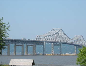
6 Chapter 1: Regional and Local Setting Chapter 1: Regional and Local Setting 1.1 Introduction The Village of Tarrytown is located on the eastern shore of the Hudson River in Westchester County, approximately 22 miles north of New York City. Tarrytown is bordered by the Village of Sleepy Hollow to the north, the Village of Irvington to the south, an unincorporated area of the Town of Greenburgh to the east and the Hudson River to the west (see Figure 1.1). Tarrytown is situated in a key location with regard to regional transportation. The Tappan Zee Bridge, located just south of the downtown area, carries I-287 and I-87 from Westchester County across the Hudson River to Nyack in Rockland County. The Saw Mill River Parkway runs to the east of the Village, connecting Manhattan and the Bronx to Westchester. Route 9, a main northsouth artery, runs through the busy downtown business area. The Village is also situated along the Hudson line of Metro-North Railroad. 1.2 Previous Plans The last Comprehensive Plan for the Village was adopted in Since then a Local Waterfront Revitalization Program (LWRP) was undertaken by AKRF and adopted in The LWRP contained a total of forty-four policies relating to Tarrytown s waterfront, addressing development, fish and wildlife, flooding and erosion, public access, recreation, historic and scenic resources, agricultural lands, and water and air. Communities that adopt LWRPs that are accepted by the State have an increased chance to obtain public and private funding for projects. In addition to this LWRP, a Waterfront Master Plan was produced by Peter J. Smith & Company. This Master Plan was intended to establish a strong connection between Tarrytown s thriving downtown retail district and its historic waterfront. The Plan envisaged a mixed-use waterfront area to complement the downtown, and included Design Guidelines and Recommendations to achieve this. A draft update to the Comprehensive Plan was completed in 2004 by Peter J. Smith & Company, and this set out a number of policies and actions for the Village, encompassing topics such as Smart Growth and Regional Development, Population and Housing, Land Use, Transportation and Infrastructure, and Economy. This Plan updates the 2004 Draft Plan and addresses additional issues within the Village as identified by discussions with the Trustees, through public workshops, and in written comments. 1.3 Development of this Plan New York State Law (Section 7-722), recognizes that among the most important powers and duties granted by the legislature to a village government is the authority and responsibility to undertake village comprehensive planning and to regulate land use for the purpose of protecting the public health, safety and general welfare of its citizens. The plan is not required under State Law, but is encouraged in order to foster cooperation among governmental agencies planning 1-1
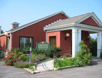
7 Chapter 1: Regional and Local Setting and implementing capital projects. The Village Trustees are the ultimate authority in adopting a Comprehensive Plan, but may designate a special board to undertake preparation of the Plan. In this case, the Mayor and Trustees have solicited the input of the Planning Board because of their experience of implementing Village zoning ordinances. The purpose of the Comprehensive Plan is to guide policy and land use decisions in the Village of Tarrytown over the next ten to twenty years. It will provide an overview of Tarrytown as it exists today, identify the Village s vision for its future, and provide a roadmap for achieving that vision. For the Comprehensive Plan to be successful, it must also reflect the concerns of the many stakeholders within the Village, including residents and business owners, local organizations, and county and state governmental agencies. To that end, on June 7, 2006 a public workshop was held at the Tarrytown Senior Center. Approximately 50 Village residents attended including business representatives and Village officials. At the meeting, BFJ Planning gave a presentation outlining the purpose of the Comprehensive Plan, a project schedule, basic demographic and land use data and a draft set of goals. The goals reflect broad areas of concern within the Village and are as follows: 1. Land Use: Provide for a balanced mix of land uses within Tarrytown and ensure that new development respects and contributes to Tarrytown s character. 2. Housing: Maintain and preserve character of existing neighborhoods and encourage housing affordable to seniors and working families. 3. Environmental Preservation: Ensure that new development respects environmentally sensitive areas, particularly water resources, and preserves the scenic quality of the community. 4. Open Space: Upgrade and increase/acquire open space and recreational facilities to enhance their function and appearance. 5. Community Facilities and Services: Upgrade and expand services and facilities to enhance their function and appearance. 6. Transportation, Circulation and Parking: Enhance traffic circulation, public transportation, and parking facilities to better serve the Village s population in a manner compatible with the character of the community. The attendees then sat at roundtables to discuss the following four broad subjects: Transportation, Open Space, Recreation and Waterfront, Land Use and Housing. They were also asked to respond to a list of prepared questions including: How would you describe the quality of life in Tarrytown? What three goals would you most like to see Tarrytown to achieve? What do you want Village government to focus on? Respondents value the historic character of the community, the Village s walkability, and ethnic diversity. They also listed traffic, preservation of open space and maintaining the historic character as three of the most important goals. The Appendix provides a complete summary of this first workshop. A second workshop was held on November 14, Relevant Regional Policies A community s growth and development patterns are shaped most directly by the land use and planning decisions made by its local government. However, many local concerns, such as air and water quality, traffic conditions, and economic growth have impacts that reach beyond 1-2
8 Chapter 1: Regional and Local Setting municipal boundaries. These can be most effectively addressed when the regional context is taken into consideration. This broader outlook for growth and development is provided by vision plans issued by state and county governments and sometimes inter-municipal agreements. For Tarrytown, several plans and initiatives have been developed on the county and inter-municipal levels that are relevant to local decisions. These are: Regional Plan Association A Region at Risk Westchester County s Patterns for Westchester: The Land and the People Hudson River Valley Greenway Program The Region A Region at Risk. Since 1922, the Regional Plan Association (RPA) has issued three plans that provide a regional perspective on land use issues in the 31-county New York/New Jersey/Connecticut metropolitan area. The Third Regional Plan, A Region at Risk (1996), presents a broad vision for improving regional quality of life and competitiveness within a global economy. The plan s specific recommendations, expressed as Campaigns, include polices on green areas, the economic development of centers, improved transportation systems, the workforce and governance. Some of these recommendations are incorporated in this plan. Westchester County Patterns. In 1996, Westchester County adopted Patterns for Westchester: the Land and the People (Patterns). Patterns serves as a policy document designed to guide sustainable development that balances economic and environmental concerns and serves the needs of a changing population. Patterns offers a broader vision and context for local-level planning initiatives. It supports looking at both local and cross-border issues and encourages inter-municipal communication and cooperation, to strengthen individual municipalities and the County overall. Since final land use authority rests with municipalities, Patterns serves as a guide and not a mandate for local planning efforts. However, the County does have two sources of influence: 1) when considering distributing grants or funding assistance for local planning efforts, the County can look at whether these local efforts conform to the vision set forth in Patterns and 2) under Article 239-m of the State s General Municipal Law, the County s Planning Department has mandatory review over certain proposed planning and zoning actions that occur within 500 feet of a municipal boundary and State and County facilities. These actions include the adoption of a comprehensive plan, and the issuance of site plan approval, special permit, or variance for property within 500 feet of a municipal boundary, County or State park or recreation area, County or State roadway, County-owned stream or drainage channel, or County or State-owned land on which a public building or institution is situated. If the County does not approve the proposed action, it can require that the referring local board approve the action by a majority plus one vote of all board members. Westchester County has exercised its right under Article 239- m in disapproving local comprehensive plans and zoning ordinances. Patterns categorizes the County s municipalities, transportation network and natural environment as centers, corridors and open space respectively. The basic premise of Patterns is that existing centers, if nurtured by necessary infrastructure, can support commercial and residential growth; that existing strip development along corridors can be reshaped to capture some benefits of centers; and that not all land uses are appropriate to all locations. From this perspective, hamlets and small towns function as service centers and remain the optimum locale for 1-3
9 North Salem Somers Peekskill Buchanan Cortlandt Yorktown Lewisboro Bedford Croton-on-Hudson Mount Kisco Pound Ridge Ossining Town New Castle Ossining Village Briarcliff Manor Pleasantville North Castle Sleepy Hollow Mount Pleasant Tarrytown Elmsford Irvington Greenburgh Harrison Rye Brook White Plains Dobbs Ferry Ardsley Port Chester Scarsdale Hastings-on-Hudson Rye City Tuckahoe Eastchester Mamaroneck Town Yonkers Bronxville Mamaroneck Village New Rochelle Larchmont Mount Vernon Pelham Pelham Manor Railway Major road Municipal boundary Tarrytown boundary COMPREHENSIVE PLAN UPDATE TARRYTOWN SOURCE: WESTCHESTER COUNTY GIS FIGURE 1.1: REGIONAL LOCATION MAP 0 20,000 ft

10 COMPREHENSIVE PLAN UPDATE TARRYTOWN SOURCE: WESTCHESTER COUNTY DEPARTMENT OF PLANNING FIGURE 1.2: WESTCHESTER PATTERNS MAP 0 4 miles
11 Chapter 1: Regional and Local Setting development investment. Tarrytown is identified as an intermediate center in Patterns. Intermediate centers are characterized by unmistakable urban activity. Almost all are on rail lines and all have well developed infrastructure systems. Most, such as Tarrytown, provide essential services to a wide surrounding area. In addition to the services and facilities found in local centers, intermediate centers are likely to have mid and high-rise apartments, large-scale retail stores, office buildings and, often, light manufacturing. Tarrytown is also strategically located at the intersection of two identified Principal Corridors. The recommendations set forth in Patterns for Tarrytown support the Village s efforts to preserve its existing patterns of development and open space. As discussed in this section and in more detail later in the Plan, preserving this open space character and maintaining the existing pattern of development are important goals for Tarrytown. Westchester County Greenprint. Westchester County is developing The Greenprint for a Sustainable Future, the Westchester County Greenway Compact Plan that will include a regional economic development strategy for the Historic River Towns of Westchester (HRTW) and which will promote the historic, cultural and natural resources of the region. (HRTW is a consortium of thirteen municipalities along the east bank of the Hudson River, including Peekskill, Cortlandt, Buchanan, Croton-on-Hudson, Town and Village of Ossining, Briarcliff Manor, Sleepy Hollow, Tarrytown, Irvington, Dobbs Ferry, Hastings-on-Hudson, Yonkers and Historic Hudson Valley.) One of the first Greenprint Compact members, Tarrytown has adopted a local law amending the local zoning ordinance to state that consideration will be given to Greenprint policies when certain land use decisions are made. Greenprint will be directly linked to the Hudson River Valley Greenway planning compact through three objectives: to develop the Greenway trail system, participate in the regional tourism strategy, and coordinate planning among local governments. Communities that participate in the Greenway Program will receive funding advantage for State agency grants and coordination of State agency actions with Greenway plans. Within Tarrytown, the most continuous trail system linking the Village to other communities in HRTW and the Greenway Compact is the Croton Aqueduct. Hudson River Valley Greenway Program. The Hudson River Valley Greenway Act of 1991 created regional connections and cooperation within New York s 10-county, 3 million acre Hudson River Valley. The directives of the program include working with local governments in the establishment of a Hudson River Trail System east and west of the Hudson, developing a strategy that would allow the Hudson River Valley to promote itself as a single tourism destination area, and working with the agricultural community to promote and protect the industry of agriculture in the Hudson River Valley. New York State s Hudson River Greenway Community Council enters into agreements with municipalities to encourage planning reforms along the lines of the Governor s Quality Communities Task Force Report. Tarrytown is one of 38 Greenway Communities in Westchester County. 1.5 Local Context According to the United States Census Bureau, the Village contains a total area of 5.7 square miles or 3,635 acres. The commercial and service core of Tarrytown lies in the northwest of the Village and merges with downtown Sleepy Hollow to the north (see Figure 1.3). The historic core 1-6
12 Chapter 1: Regional and Local Setting contains numerous buildings of historical and architectural interest and provides an attractive downtown, situated on the banks of the Hudson. The Village is bisected by the New York State Thruway and the approach to the Tappan Zee Bridge. The southern half of the Village contains significant tracts of undeveloped land. This area is characterized by low density residential development, Westchester County Park and also three large estates: Sunnyside, Lyndhurst Castle and Belvedere. The Tarrytown Lakes lie in the northeastern corner of the Village, and the land area adjacent to the Tarrytown Lakes has been designated by the New York State Department of Environmental Conservation (NYSDEC) as the Tarrytown Lakes Watershed Critical Environmental Area. All land area west of Broadway (Route 9), within the Village of Tarrytown, has also been designated part of the Hudson River CEA by New York State and Westchester County. As is the case with most other municipalities in Westchester County, Tarrytown is experiencing the problems associated with an increasing level of development, in particular resulting from a high level of traffic congestion. The Village must devise a set of policies to ensure development takes place in a manner compatible with the existing character and that the quality of life of its residents is maintained. 1-7
13 CROTON-AQUEDUCT TRAIL Sleepy Hollow Mount Pleasant WILDEY ST. BROADWAY TARRYTOWN LAKES MAIN ST. Train Station BENEDICT AVENUE TAPPAN ZEE BR. Tarrytown TARRYTOWN-WHITE PLAINS RD. Greenburgh NEW YORK STATE THRUWAY S. BROADWAY Elm Legend State Road County Road Town Boundary Railroad Trailway COMPREHENSIVE PLAN UPDATE TARRYTOWN SOURCE: WESTCHESTER COUNTY GIS FIGURE 1.3: LOCAL CONTEXT ft
14 Chapter 2: Land Use and Zoning Chapter 2: Land Use and Zoning Goal: Provide for a balanced mix of land uses and ensure that new development respects and contributes to Tarrytown s character. Objectives: Conduct a build-out analysis to identify Tarrytown s capacity for growth Evaluate possible alternative zoning districts for Fordham University (Marymount College) and the Kraft Foods site Address the issue of non-conforming lots and structures in the Village s residential districts Develop floating zones for senior housing and affordable housing The questionnaire distributed in 2004 (by Peter J. Smith) to a total of 5,700 Village households contained a number of questions in relation to land use regulations in the Village. The results of this are shown in the table below. A total of 82 percent of the respondents felt that stricter land use regulations should be developed and enforced. TABLE 2-1 Survey Results for Land Use Regulations Question Strongly Agree Agree No Opinion Disagree Strongly Disagree Commercial growth should be promoted in the 13% 35% 10% 27% 15% Village Industrial growth should be promoted in the 6% 10% 10% 39% 36% Village. Stricter land use regulations (zoning, sign, 43% 39% 8% 8% 2% landscaping) should be developed and enforced to protect our communities residential areas. See appendix for full results of the survey At the workshop held in June 2006, Land Use was rated as the second most important goal. From these polls, it is clear that the community has strong views as to how the Village should develop. Issues that were raised at the workshop included downtown revitalization, the importance of allowing mixed use, historic preservation, and a suggestion for floating zones for senior and affordable housing. Residents also value the unique characteristics of each neighborhood such as Pennybridge, the Crest, and Miller Park and the Plan should promote neighborhood preservation. 2.1 Introduction The built environment the type, location and intensity of existing and future land uses defines the character of a village. It is important to know where and how much land is presently developed for residential, business, recreation and other uses. Examining these developed areas helps residents visualize desirable and undesirable aspects of land use patterns and provides a foundation for the planning policies and objectives guiding future development of vacant, as well as underdeveloped parcels. A municipality s zoning and subdivision regulations are the major regulatory tools with which it can regulate land uses and influence future development patterns 2-1


15 Chapter 2: Land Use and Zoning and practices. Below is a summary of the existing land use, development patterns and zoning in the Village of Tarrytown. 2.2 Land Use Land Use Tarrytown is a largely built-out residential suburban community within the New York metropolitan area. According to the United States Census Bureau, the Village contains a total area of 5.7 square miles, 2.7 of which are under water, leaving a total of three square miles of land area. Population density is approximately 3,725 people per square mile of land area, or 5.8 persons per acre. This is higher than the neighboring Village of Irvington at 3.7 persons per acre but lower than the Village of Sleepy Hollow at 6.3 persons per acre. A breakdown of the approximate acreage of the major land use categories in 2006 is shown in Chart 2-1. These figures are based on survey and Westchester County Geographic Information Systems (GIS) data. Residential. Residential uses account for the vast majority of the Village s land area, see Figure 2.1. The higher density residential areas are located in and around the downtown, and along Route 119. There are some examples of multi-family residences, such as Asbury Terrace (107 units), Rivercliff (21 units), Franklin Tower (90 units), Tappan Manor (167 units), and Washington Irving Gardens (66 units). Franklin Towers Asbury Terrace Community and Institutional. Community and institutional uses comprise a large portion (19 percent) of the land use in Tarrytown. There are three public schools in Tarrytown: the Tappan Hill School on Ichabod Lane, John Paulding School on North Broadway, and the Washington Irving School on Franklin Street and Broadway. There are also two private schools: the Hackley School which is located on the boundary with Greenburgh, and the Transfiguration School. 2-2


16 Chapter 2: Land Use and Zoning CHART 2-1 Land Use in Tarrytown Other 4% Vacant 16 % Office 9% Recreational/ open space 7% Residential 39 % Residential Commercial Institutional/ community Recreational/ open space Office Vacant Other Institutional/ community 19 % Commercial 6% Source: Westchester County GIS, 1996, 2006 Survey Marymount College, the undergraduate women's College of Fordham University is located off Neperan Road on a 25-acre site. St. Jude s Habilitation Institute, located on Wilson Park Drive, is also a significant land user. Office. There is a concentration of office uses centered on the Thruway, south of the downtown. Large office uses based here include the Talleyrand office park, the Kraft Foods Management Center, and the Thruway Authority. Talleyrand Office Park 2-3
17 Mount Pleasant Sleepy Hollow TARRYTOWN LAKES TAPPAN ZEE BR. Tarrytown ROUTE 119 NEW YORK STATE THRUWAY Greenburgh Elmsford Irvington Land Use Legend Residential Commercial Office Community Services/Institutional Open Space/ Recreation Vacant/ Undeveloped Waterbodies COMPREHENSIVE PLAN UPDATE TARRYTOWN SOURCE: WESTCHESTER COUNTY GIS, 1996 FIGURE 2.1: LAND USE ft


18 Chapter 2: Land Use and Zoning Commercial. The commercial and service core of Tarrytown lies in the northwest of the Village and merges with downtown Sleepy Hollow to the north. This historic core contains numerous buildings of historical and architectural interest and provides an attractive downtown, with a healthy mix of retail, restaurant, and commercial uses. The downtown also contains a concentration of institutional and community uses, including the Village Hall, a senior center, and a number of downtown parks. The Village has a second retail and service center, located at the intersection of South Broadway and Route 119, known as the Bridge Plaza Shopping Center. This contains the Village s largest supermarket, Stop & Shop, in addition to various other neighborhood services, including a delicatessen, restaurant and hairdresser. Bridge Plaza Shopping Center, Tarrytown Other large commercial uses in Tarrytown consist of a number of large hotels and conference centers, including the Tarrytown House Estate and Conference Center located on East Sunnyside Lane, the Castle on the Hudson on Benedict Avenue, and the Doubletree hotel on South Broadway. Open Space and Recreation. There are a number of municipal parks in Tarrytown totaling approximately 140 acres. These facilities are detailed in Chapter 7. Large Estates. Tarrytown is also distinguished by a number of large estates. The southern half of the Village contains three large estates: Lyndhurst Castle, Sunnyside, and the Belvedere Estate. Lyndhurst Castle is operated as a museum by the National Trust for Historic Preservation. Sunnyside, the former home of Washington Irving, is run by Historic Hudson Valley. Belvedere Estate is now owned by the Unification Church. The large, open expanses of these properties endow this corner of the Village with a very pleasant, rural character. Other substantial properties include the Hackley School, and Marymount College/Fordham University. Vacant Land. A number of parcels in the south of the Village remain vacant. These include a large parcel owned by Kraft and three vacant parcels east of Route 9 adjacent to Taxter Ridge Park in the Town of Greenburgh. Two of these parcels are owned by Esposito and one large parcel is owned by the Unification Church. The Village has been working with the Trust for Public Land to acquire these parcels. 2-5
19 Chapter 2: Land Use and Zoning 2.3 Zoning The Village of Tarrytown has twelve primary zoning classifications, including nine single-family residential districts (R-80, R-60, R-40, R-30, R-20, R-15, R-10, R-7.5, and R-5), five multi-family residential districts (M-4, M-3, M-2, M-1.5, and M-1), one industrial district (ID), seven commercial districts (OB, MU, LB, RR, NS, GB, and WGBD), and two other districts (Waterfront - WD and Historic Commons HC) Residential Zones The single-family residential districts allow for single family homes on minimum lot sizes ranging from 5,000 to 80,000 square feet. The highest density single-family zone, R-5, is mapped in a very small area in the downtown, and the lowest density zone, R-80 is mapped around the Tarrytown Lakes area (see Figure 2.2). The multi-family residential zones are all located north of Route 119, with the highest density zones concentrated in the northwestern corner of the Village. Marymount College occupies a significant proportion of the R-20 district, and the Belvedere Estate and Westchester County Park occupy a large proportion of the R-40 district in the southwest of the Village. The two lowest density residential districts, R-60 and R-80 were created in September 2000, after the conclusion of a moratorium. These were established by the Village to preserve open space and to reduce the impacts associated with new residential development, including impacts on traffic, public infrastructure, public schools and community resources. A new Historic Commons district was also created for the same purposes. This district is mapped in the southwest of the Village and encompasses all of Lyndhurst Castle, Sunnyside, and a portion of the Belvedere Estate and Kraft Foods. This district allows for single-family residences on a minimum lot size of five acres, and also for multi-family residences in existing or new building(s), senior housings, bed & breakfasts, inns, public restaurants, cultural institutions, conference centers, churches, synagogues, parish houses, and motor hotels subject to compatible use permits Commercial/Mixed Zones The Village has one industrial district, ID, which allows for light manufacturing and commercial uses which are consistent with the needs of the community. This district is mapped in two very small areas, between the waterfront and the downtown and is intended to act as a transitional zone by allowing high but not unrestricted intensities of land use between waterfront industry and the railroad on the west and residential areas to the east. A total of seven commercial districts are provided, which allow for a broad range of business and commercial uses. The Office Building District, OB, contains the Kraft Foods Management Center. The Tarrytown House Estate and Conference Center is also located in this district, as a pre-existing non-conforming use. The Waterfront District is mapped along almost the entirety of the waterfront, and this allows for parks and playgrounds, marinas, mass transit facilities, and municipal facilities. 2.4 Historic Districts and Landmarks Tarrytown contains three historic districts: Grove Street, Main Street and South Tarrytown (see Figure 2.2). Chapter 305 (Zoning) of the Village s code requires that for any development either in or within three hundred feet of an historic district, the Planning Board can require or permit increased building heights and can review, approve, and regulate architectural styling and the 2-6


20 COMPREHENSIVE PLAN UPDATE TARRYTOWN FIGURE 2.2: ZONING MAP 0 SOURCE: VILLAGE OF TARRYTOWN, ft
21 Chapter 2: Land Use and Zoning TABLE 2-2 Summary of Existing Zoning Districts Intent District Maximum Principal Building Coverage/ Lot Coverage Single-family housing Multiple Dwellings Minimum Lot Size/ Density One-Family Residence R-80 10% 80,000 square feet One-Family Residence R-60 12% 60,000 square feet One-Family Residence R-40 14% 40,000 square feet One-Family Residence R-30 16% 30,000 square feet One-Family Residence R-20 18% 20,000 square feet One-Family Residence R-15 20% 15,000 square feet One-Family Residence R-10 22% 10,000 square feet One-Family Residence R- 24% 7,500 square feet 7.5 One-Family Residence R-5 30% 5,000 square feet Multifamily Residence M-4 1-family D.U. 18% 20,000 square feet Multifamily 10% Multifamily Residence M-3 1-family D.U. 20% 15,000 square feet Multifamily 10% Multifamily Residence M-2 1-family D.U. 22% 10,000 square feet Multifamily 20% Multifamily Residence M family D.U. 24% 7,500 square feet Multifamily 20% Multifamily Residence M-1 1-family D.U. 26% 5,000 square feet Multifamily 15% 15,000 sq ft/d.u. 435, ,000 sq ft Commercial Office Building OB Max. of all buildings, structures and paved areas: 45% Mixed Use MU Limited Business LB Neighborhood Shopping NS Restricted Retail RR General Business GB Waterfront Business WGBD General Max. of all buildings, structures and paved areas: 45% 18% D.U % other 18% D.U. 20% other 18% D.U % 18% D.U. 75% other 20,000 sq ft/ D.U. 43, ,600 other 20,000 sq ft/d.u. 5,000 other 20,000 sq ft/ D.U. 1,000-5,000 other 20,000 sq ft/ D.U. 5,000 other 35% 0.4 acres for principal permitted use; 2 acres for special permit uses Mixed Waterfront WD 35% 0.4 acres for principal permitted use; 2 acres for special permit uses Industrial Industrial ID 0 75% Historic Historic Commons 15% 217,800 sq ft (5 acres) Water-related Water-Related Industry industry Overlay Source: Village of Tarrytown Zoning Code 75% 0 2-8
22 Chapter 2: Land Use and Zoning types, textures, and/or colors of building facade materials proposed. This is intended to achieve conformity, equality, compatibility and proper visual scale with adjacent buildings. In addition, special permit uses within a historic district have to meet additional criteria in order to be considered. In addition, Chapter 191 of the Village Code provides criteria for designating landmarks in the Village which includes association with persons or events of historic significance to the village, region, state or nation and illustrative of historic growth and development of the village; region or nation. There are some additional buildings located in the Village, which should be considered for designation as historic landmarks, such as the Wachovia Bank building on Route 9, the Belvedere Estate, and parts of Marymount College. 2.5 Build-Out Analysis A build out analysis was included as part of this Plan. This provides a general estimate of the future growth potential in Tarrytown if the Village was built out to the maximum extent permitted by the laws currently in place. The first step was to calculate the amount of land that has not been developed to date. This was done by studying 2004 aerial photography of the Village and combining this with current land use and parcel information. This identified all of the significant undeveloped parcels in the Village, and the areas of each undeveloped parcel were generated from GIS (see Figure 2.3). The next step was to overlay the Village s zoning map over the undeveloped areas to determine what zoning district each undeveloped parcel was located in. The zoning determines the maximum development potential of the parcel. The third step was to deduct the non-buildable land from each of the undeveloped areas. First, environmentally restrained land was subtracted from each area. This included: Steep slopes, defined as land with a gradient of 25% or over (taken from a Westchester County GIS coverage), and NYSDEC designated wetlands The development potential of parcels in single-family zoned districts was calculated by subtracting 10 percent of gross area to account for infrastructure (including roads and stormwater systems). For parcels zoned for non-residential use, of which there are two: Historic Commons and Mixed Use, a separate methodology was applied. For the Kraft parcel, located in the Historic Commons district, where the permitted principal use is single-family residences (and uses requiring compatible use permits such as multi-family residences, senior housing, bed-and-breakfasts, inns, public restaurants, cultural institutions, conference centers, and churches), the maximum number of single-family residences was calculated. For the Mixed Use district, where the maximum total coverage of all buildings and structures is 12 percent with a height of 6 stories, the total potential square footage was estimated by obtaining 12 percent of the net lot area and multiplying that number by 6. Table 2-3 shows the theoretical amount of potential future residential and commercial development in Tarrytown. An estimated 164 acres of undeveloped land could be developed for 2-9
23 Chapter 2: Land Use and Zoning residential or mixed use development. According to existing zoning, if all available land was developed, it could include an estimated 74 additional homes, and at least 161,168 square feet of additional commercial space. TABLE 2-3 Theoretical Development Build-Out Parcel Zone Undeveloped Acreage Undeveloped Minus Constraints Undeveloped Minus 10% (in acres) Potential Development Legends at Wilson Park R houses Legends at Wilson Park houses Bagarotti houses Holy Spirit Association R houses Esposito houses Islamic Council houses Total Residential Kraft HC houses Simon MU ,168 sq ft Total Other
 Islamic Council Bagarotti Les Oiseaux Holy Spirit Association Belvedere Estate Esposito Legend")

24 Legends at Wilson Park Fordham Graduate Center Marymount College of Fordham University Kraft (developed) Simon Kraft (undeveloped) Islamic Council Bagarotti Les Oiseaux Holy Spirit Association Belvedere Estate Esposito Legend Water body Wetland Steep Slope 25% Vacant Land Land with Development Potential COMPREHENSIVE PLAN UPDATE TARRYTOWN FIGURE 2.3: VACANT LAND & LAND WITH DEVELOPMENT POTENTIAL SOURCE: WESTCHESTER COUNTY & TOWN OF GREENBURGH GIS ft
25 Chapter 2: Land Use and Zoning Development Potential on Large Tracts The build-out analysis as described in the previous section was carried out for the undeveloped parcels in the Village. However, as in other built-out communities, much of the development potential remaining is contained within the larger tracts of institutional and commercial land, such as the Kraft Foods site, where existing uses may become obsolete as the sites sold and developed for more profitable uses. These sites are also shown on Figure 2.3. These large sites are all currently developed and in use, and thus should be considered separate to the build-out analysis. The assessment of their development potential, in combination with the build-out analysis offers a more complete picture of Tarrytown s growth potential. This analysis of large developed parcels is depicted in Table 2-4. As can be seen, Kraft and Marymount College are both very large land users in the Village. If their current use was to become obsolete, or ownership of the sites changed, the development of these sites would have a significant impact on the Village. Marymount College at its current zoning of R-20 could accommodate a maximum of 53 single-family dwellings. The redevelopment of the Kraft site could yield 162 dwellings at its current zoning of OB. TABLE 2-4 Residential Development Potential of Large Developed Tracts Zoning District Residential Development Potential (houses) Tract Acreage Fordham Graduate Center R Marymount College R Kraft OB Belvedere R Total Development in Adjoining Municipalities Development in neighboring municipalities will also have an impact on Tarrytown s economy. Significant projects that are ongoing at present include: Sheraton Hotel Town of Greenburgh Avalon Green II Town of Greenburgh Westwood Development Town of Greenburgh Lighthouse Landing Sleepy Hollow former General Motors plant is being converted to a residential development of over 1500 residential units. South Astor Street conversion of MTA power station to residential use - Village of Irvington 2-12
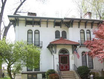
26 Chapter 2: Land Use and Zoning 2.7 Recommendations Residential Districts New development runs the risk of altering the character of the Village s older residential neighborhoods, such as the Tarrycrest neighborhood. There are a number of options to consider in order to resolve this issue, all of which include a review of the Village code. One option for further consideration is form-based zoning. Form based zoning is different from conventional zoning in that it emphasizes regulating the physical form rather than separating uses in different zones. This approach relies more on illustration and graphic depiction than long lists of uses and specifications. Form-based zoning is a relatively new concept. There are very few codes that have been published and each is very different and unique to the individual communities for which they were developed. Though each published code is unique, they implement all or some of the following three components: 1. Definitions - allow for a full explanation of all vital design elements of form-based code (based on the context of each individual community). 2. Regulating Plan - similar to a zoning map in that both delineate where specific rules apply but the Regulating Plan contains more detailed information concerning form including: a. Coding key for building envelope design standards and specific information for the character of each building site. b. Illustrations of the relationship between sites and public spaces and to surrounding neighborhoods. c. Details of all proposed streets and the blocks they define. 3. Building Envelope - describes in written and graphic form the requirements of each zone and guides the basic parameters of: a) Siting b) Build-to Line (BTL) c) Height range of acceptable heights Minimum reflects requirement to maintain street wall Maximum reflects highest before the building appears overwhelming and out of context d) Uses (by floor or building, general such as office, retail, residential) Additional controls may govern architectural styles and more detailed design elements such as fenestration and building materials. Marymount College In 2005, Fordham University announced its plans to close Marymount College, effective June The build-out analysis contained in this Plan indicates that the Marymount property contains development potential for approximately 53 houses at its current zoning of R-20. It is not known what the University intends to do with the property in the long-term, and various options for its rezoning were discussed. These options included: 1) upzoning the property to R- 40, 2) zoning it as an institutional district, similar to institutional zones in other municipalities, or 3) creating a scenic overlay district. The Village may also seek to designate the Butler Hall Building, with its dome and historic interior, as a local landmark to ensure its protection. 2-13
27 Chapter 2: Land Use and Zoning The development constraints on the property, including the presence of steep slopes and wetlands, in addition to the site s location in the Tarrytown Lakes drainage basin, were also raised as an issue. In the short-term, a site survey should be carried out for the property to determine its true development potential. This would provide the basis for a clearer evaluation of the longer-term options (Any build-out analysis for specific sites within the Village must take into account environmental constraints such as steep slopes, wetlands and soils in order to arrive at a realistic development scenario.). Marymount College, founded in 1907, was a significant early institutional use in the Village. In the longer-term, the potential for designating portions of it as a historic landmark, should be explored. OB District As the build-out analysis identified, the redevelopment of the Kraft site for residential uses would yield approximately 162 dwellings, which would be a significant new residential development in the Village. The minimum lot size for a dwelling unit in the OB district is 15,000 square feet, which is equivalent to the R-15 district, that allows three dwelling units per acre. In addition to the Kraft site, there are a number of other sites in the Village located in the OB district, all of which are developed for office or business use. In the interests of maintaining a diversified tax base, the Village wishes to encourage the continued use of these sites for office uses. Removing residential as a permitted use from the OB district will ensure a continuation of the office use of these sites. Taxter Ridge Park Preserve and Esposito Parcel Taxter Ridge is a property of almost 200 acres in the Town of Greenburgh, which was acquired through the collaboration of New York State, Westchester County and the Town of Greenburgh in 2004 to be preserved as parkland. This property, the largest undeveloped tract of land in southern Westchester County, will be maintained by the Town of Greenburgh. Tarrytown is concerned with the development of a parcel located in the Town of Greenburgh, which is enclosed by the Taxter Ridge property. This parcel, known as the Esposito parcel, comprises approximately 55 acres. It is currently zoned as CD R-40 Conservation District R-40. This property could potentially yield a maximum of 60 dwellings under its current zoning. In the interests of conserving environmentally sensitive land, Tarrytown will continue to petition the Town of Greenburgh to upzone this property to a lower density zone, such as an R-60 zone. Within the Village, there are two properties located near the Taxter Ridge Preserve which the Village wishes to acquire; the Esposito and Unification Church properties. The Village will continue to pursue the acquisition of these parcels. Belvedere Estate The Belvedere Estate is owned by the Unification Church, which recently received approval for construction of a new West Rock Church with an educational building, offices, and pre-school building on the property. The estate house itself is architecturally and historically significant and the Village is assured that any future use of the property will include adaptive re-use of the house, possibly as a hotel, and that it will respect and enhance the estate s historical character. 2-14


28 Chapter 2: Land Use and Zoning Historic landmarks There are only five buildings designated as historic landmarks at present. The Village should review this list, and identify additional buildings meriting protection as historic landmarks. Tarrytown House Estate and Conference Center Tarrytown House Conference Center is located on East Sunnyside Lane, in the OB district, although a conference center is not listed as a principal permitted use. A definition for conference center was added to the code in 2001, as follows: A Hotel, Motel, or Inn that provides meeting rooms, recreation facilities, and/or dining facilities that may be open to the general public for catering activities, and they are permitted in the Historic Commons and Waterfront General Business districts. Conference centers should be allowed by Planning Board special permit in the OB district. Tarrytown House Conference Center Marymount College Lighthouse Landings Over 1500 residential units are proposed at the former General Motors plant in Sleepy Hollow. This is expected to have significant traffic and parking impacts on the Miller Park neighborhood and emergency response times. The Village has been reviewing the Environmental Impact Statements as the application has progressed, and will continue to seek to limit and mitigate potential adverse environmental impacts to the Village as a result of this proposal. 2-15


29 Chapter 3: Demographics Chapter 3: Demographics 3.1 Introduction This chapter examines Tarrytown s demographic characteristics including population, race and ethnicity, housing, income, and economic characteristics, and provides an overview of existing conditions and recent trends. Tarrytown contains two census tracts: numbers 114 and 115. Census Tract 115 encompasses the area north of Van Wart Avenue and west of the Croton Aqueduct, and Tract 114 includes the rest of the Village. This analysis also includes some figures for the Villages of Irvington and Sleepy Hollow, Westchester County, and New York State, where comparisons are considered relevant. Figure 3.1: Census Tracts in Tarrytown 3.2 Population Growth The US Census Bureau estimates the 2004 population for Tarrytown at 11,402 which represents a community-wide population increase of 2.8% since the 2000 Census. Tarrytown experienced a decline in population between 1970 and 1980, which was similarly observed in neighboring villages (see Table 3-1), but the population then increased between 1980 and 2000, albeit at a lower rate than comparison areas. Based on the 2004 estimate, Tarrytown s population has now recovered beyond its 1970 peak. 3-1
30 Chapter 3: Demographics Year Tarrytown Total Population TABLE 3-1 Population Change in Tarrytown since 1970 %age Change Tarrytown %age Change Irvington %age Change Sleepy Hollow %age Change Westchester County %age Change NY State , , , , (estimate) 11, Source: U.S. Census Bureau, CHART 3-1 Tarrytown Population Change: ,600 11,400 Population 11,200 11,000 10,800 10,600 10,400 10, estimate Year Source: U.S. Census Bureau, Race and Ethnicity According to the U.S. Census, the Village of Tarrytown is approximately 77 percent White, 8 percent African American, 6 percent Asian and 16 percent Hispanic. The race and ethnicity of Village residents is similar to the Westchester County profile as a whole. Since 1990 the racial composition has been undergoing change, as can be seen from Table 3-2. Between 1990 and 2000 the Village s White population declined by approximately 8 percent and its Hispanic population grew by 2%; its Asian and African-American population increased by 1 percent. Race/Ethnicity TABLE 3-2 Race and Ethnicity Percent of Population: Tarrytown Percent of Population: Westchester County White alone 85% 77% 71 % Black/African American alone 7% 8% 14 % American Indian & Alaskan Native 0.1% 0% 0% 3-2
31 Chapter 3: Demographics alone Asian or Pacific Islander alone 5% 6% 5% Other 3% 9% 10% Hispanic (may be of any race) 14% 16% 16% Source: U.S. Census Bureau, 1990 (SF3, Tables P8 & P10) & 2000 (SF3 Tables P6 and P7), Westchester County Planning Department 3.4 Age Profile An analysis of Tarrytown s age structure is helpful in evaluating future needs for services and facilities in the community. Approximately 30 percent of Tarrytown s residents are over the age of 50, as shown in Chart 3-2. While the Village s overall population increased between 1990 and 2000, the number of residents ages 20 to 34 decreased by 5 percent. During this period the population of residents ages 45 to 55 increased by 9 percent. CHART 3-2 Age Breakdown in Tarrytown, and older 15% 0 to 19 22% 50 to 64 15% 35 to 49 25% 20 to 34 23% Source: U.S. Census Bureau, Housing According to the U.S. Census Bureau, Tarrytown contained a total of 4,688 housing units in 2000, which is an increase of 377, or 9 percent, from As shown in Table 3-3, when compared to its neighbors and to the county, Tarrytown experienced the largest percentage increase in housing units between 1990 and 2000, indicating a strong demand and buoyant housing market. Compared to the neighboring villages of Sleepy Hollow and Irvington, Tarrytown had the largest increase in housing units between 1990 and 2000 (housing units in Sleepy Hollow increased by 3 percent and in Irvington by 1 percent). In relation to housing tenure, 53 percent of Tarrytown s housing units were owner occupied, which is slightly lower than the average owner-occupancy rate for Westchester County. 3-3
32 Chapter 3: Demographics TABLE 3-3 Increase in Number of Housing Units from Municipality %age Change Village of Tarrytown % Village of Irvington % Village of Sleepy Hollow % Westchester County 336, , % Source: U.S. Census Bureau, Economic Characteristics The majority of Tarrytown s residents work outside of the Village but within Westchester County. On average, residents commute approximately 30 minutes to work. Approximately 70 percent travel by automobile, 20 percent by public transportation, and the remainder bicycle, walk or work at home. Over 50 percent of Tarrytown s residents are employed in management and professional occupations, approximately 25 percent are employed in sales and office occupations and 15 percent in service occupations. The most significant employment sector within the Village itself is educational, health and social services, which accounts for 28 percent of Tarrytown s employment base, followed by professional management and administrative services, which account for 16 percent. As reported by Westchester County in 2004, Tarrytown had eight employers employing over 200 people. Chapter 5 contains a more detailed description of Tarrytown s economy. The median household income in 1999 in Tarrytown was $68,762, which is $5,180 more than the median income for Westchester County. The median household income divides the total frequency distribution into two equal parts: one-half of households earn less than the median and one-half of the households earn more than the median income. 3-4
33 Chapter 4: Housing Chapter 4: Housing Goal: Preserve and improve the character of existing neighborhoods and encourage housing affordable to seniors and working families. Objectives: Preserve historic areas Provide more housing choice such as apartments and condominiums in the downtown area Evaluate and amend existing bulk and setback standards for residential districts to ensure that new residential development is in keeping with the scale of existing neighborhoods Develop a comprehensive affordable and senior housing policy For many residents, the quality of Tarrytown s housing and neighborhoods is a critical component of the Village s identity. At the public workshop in June 2006, participants rated the goal of maintaining and preserving Tarrytown s existing housing stock as an important one. Increasing the range of housing choices, ensuring the preservation of the Village s historic character, and preventing the overdevelopment of the Village were identified as significant issues. One participant at a workshop suggested that the housing goal include the improvement of the character of existing neighborhoods, not just their preservation. The questionnaire distributed by Peter J. Smith to a total of 5,700 households in 2004 contained four questions concerning housing in the Village. The results of this survey are shown in the table below. A total of 60 percent of the respondents agreed that there is sufficient diversity in Tarrytown s housing stock. A total of 56 percent think that additional subsidized senior citizen housing should be available and 55 percent felt that more affordable housing should be offered. TABLE 4.1 Survey Results for Housing Question There is sufficient diversity in Tarrytown s housing stock Additional subsidized senior citizen housing should be available in our communities New housing developments should be clustered on smaller lots to preserve open space in our community Our community should offer more affordable housing opportunities for all residents and potential residents. See Appendix B for full results of the survey Strongly Agree Agree No Opinion Disagree Strongly Disagree 18% 42% 16% 18% 5% 19% 37% 27% 12% 5% 28% 37% 14% 14% 6% 26% 29% 15% 20% 10% 4.1 Introduction The 2000 U.S. Census found that there were 4,688 housing units in the Village, of which 3.3 percent were vacant. Over half of the occupied housing units were owner-occupied. Almost 42 percent of housing units were single-family units. 4-1
34 Chapter 4: Housing 4.2 Residential Zoning Districts Of the fourteen residential zoning districts in the Village, nine are reserved for single-family homes. There is no two-family residential zoning district, but there are five multi-family residential districts which allow for a range from one-family to multi-family units Single-Family Residence Districts R-80 District. This district is located in the northeastern corner of the Village, surrounding Tarrytown Lakes, and adjoining the Village of Sleepy Hollow. Most of this district is undeveloped with approximately 50 acres of vacant land area. The zoning code provides for a Special Tarrytown Lakes Setback of 300 feet inland from the mean high-water mark along the entire circumference of the lakes. Some of the vacant land in this district is currently the subject of the Legends at Wilson Park subdivision, discussed in Section 4.4. Much of the remaining vacant land in this district is owned by the Village, and due to the significant environmental constraints, is unlikely to ever be developed. R-60 District. This district is located west of Tarrytown Lakes in the northern portion of the Village, and also south of I-287, along Sheldon Avenue and West Lake Drive, and east of South Broadway, north of Tarryhill Road. The area near Tarrytown Lakes forms part of the Wilson Park subdivision, and upon completion, will contain very little further development potential. The portion of the district south of I-287 and north of Sheldon Avenue contains the Sheldon Brook and Talleyrand State designated wetlands. The presence of the wetlands rules out the possibility of development here. The remainder of the district is largely undeveloped and contains significant development potential. R-40 District. The district in the south of the Village encompasses the land recently acquired by Westchester County and also part of the Belvedere Estate. The district in the north includes Fordham University (Marymount College) and St. Jude s. It is unlikely that much residential development will take place in these areas in the near future, but in the long term it is possible that Fordham and St. Jude s may change ownership. This may result in future residential development. R-30 District. This district is concentrated in the north of the Village, adjoining the Village of Sleepy Hollow. The library, Patriots Park, and a portion of Sleepy Hollow High School are located in this district. Oak Avenue and Cobb Lane are the residential streets in the district. R-20 District. This district is characterized by single-family homes on medium sized lots. Marymount College and Hackley School are the main non-residential uses in the district. In the north of the Village, the district contains land south of Cobb Lane, including Walden Road and Suncliff Drive, north of Beech Lane. In the south, Round a Bend Road is a more recent residential subdivision. 4-2

. There is very little development potential remaining in this district.")


35 Chapter 4: Housing R-20 House on Beech Lane R-20 Landmark House on Cobb Lane R-15 House on Beech Lane R-15 District. In the south this district contains Tarry Hill Road, Powder Horn Way, Old Forge Lane, and Stephen s Drive. In the north it encompasses Heritage Hill Road, Birch Way, Doris Lane and Detmer Avenue in addition to two pockets further north (formed by McKeel Avenue, Beech Lane and Warren Avenue, and River Terrace and Lake Terrace). There is very little development potential remaining in this district. R-10 District. This district is characterized by older, single family homes around the downtown and a newer subdivision in the south around Deertrack Lane, which also contains Pintail Lake. In the north of the Village, there is a large area of R-10 development north of Benedict Avenue on both sides of Highland Avenue. The main non-residential use in the district is Lagana Field. There are two pockets of R-10 west of Broadway: along Van Wart and Paulding Avenues, and along the north side of Tappan Landing Road. There is very little development potential left in this district. R-10 Houses on Kerwin Place R-7.5 District. Similar to the R-10 and R-15 districts, this district is scattered throughout the Village. Houses are typically small, such as the examples shown below from Franklin Street. One of the newer examples of development in this district is the development between Prospect and Martling Avenues off Benedict Avenue. The Washington Irving School is located in this district. 4-3


36 Chapter 4: Housing R-7.5 Houses on Franklin Street R-5 District. This district has the smallest minimum lot requirements, at 5,000 square feet, and hence is the densest single-family district in the Village. There are only two very limited locations for this district: Hanford Place adjoining Sleepy Hollow and Croton Avenue. There is no development potential remaining in this district Multi-Family Residence Districts Tarrytown contains five multi-family residence districts, which are distinguished from each other by their minimum lot sizes. All of the multi-family districts are mapped north of I North Broadway M-2 District Franklin Towers M-3 District M-4 District. This has the largest minimum lot size of 25,000 square feet. It is mapped in only one location, north of Route 119. This lot is fully developed. M-3 District. This district is mapped in several locations, most of which are fully developed. This district includes the Franklin Towers development, which is located adjacent to the railway station. M-2 District. This district, with a minimum lot size of 10,000 square feet, is mapped in and around the downtown. M-1.5 District. This district includes many examples of older, lower density development in the downtown, and is mapped along both North and South Washington Streets. 4-4


37 Chapter 4: Housing M-1 District. This district is mapped in and around the downtown and has the smallest required minimum lot size. 4.3 Housing Costs When the Census was conducted in 2000, the median value of homes in Tarrytown was reported as approximately $282,000. This was slightly lower than the median value in Westchester County of $286,000 and in the neighboring communities of Sleepy Hollow and Irvington, where median values were $340,000 and $378,000 respectively. Since the 2000 Census, median house prices have increased. According to the Westchester-Putnam Multiple Listing Service Residential Real Estate Sales Report, the median sale price of a single family house in Westchester was $716,125 in the third quarter of Recent statistics from the MLS by type of unit are shown in Table 4-2. TABLE 4-2 Median Sale Prices in Westchester County Type of Property 3 rd Quarter 2003 Windle Park M-1 District 3 rd Quarter 2004 Median Sale Price 3 rd Quarter 3 rd Quarter Change $ % Change Single Family 588, , , ,125 4, % Houses Condominiums 303, , , ,000 (5,000) -1.3% Cooperatives 125, , , ,000 10, % 2-5 Family Houses 424, , , ,450 (2,550) -0.4% Source: MLS Inc, Proposed Housing Developments Legends at Wilson Park This 48 acre site is situated in the R-60 and R-80 districts, east of Wilson Park Drive and south of County House Road. The site developers are proposing to subdivide the area into single-family residential lots utilizing a cluster subdivision. The site is located within the watershed of Tarrytown Lakes. 4-5

38 Chapter 4: Housing Ferry Landings This mixed-use project, approved in 2006, proposes the development of 250 residential units along the waterfront on the former asphalt plant site. These residential units will comprise a mix of townhouses and loft apartments and are expected to generate approximately 533 residents. The apartments will be located above ground-floor commercial uses in two and three story buildings. The townhouses will be divided into 103 two-bedroom units and 64 three-bedroom units. (Ferry Landings, FEIS, November 2005, Chazen Companies) 4.5 Housing Affordability and Choice Tarrytown, like most Westchester communities, has come to face a shortage of moderately priced housing. The most significant reason for this is the substantial increase in real estate values. The value of new and existing homes has grown faster than the financial ability of many to pay property taxes or move to a larger home within the village. With this shortage it has become harder for senior citizens, young people, police, firefighters, other municipal employees, workers in local stores, and teachers, among others, to afford to live in Tarrytown. This results in a lack of demographic diversity and a possible reduction in available services in the Village. Village Mews Affordable Housing Westchester County s Housing Opportunity Commission published an Affordable Housing Allocation Plan in 2005, which allocated 111 designated affordable housing units to Tarrytown by 2015, which included 6 units already constructed. The construction of the total allocated number of affordable units should be a goal for the Village to achieve by Moderate-Income Housing The Village s zoning code has included a provision for moderate-income housing (Section ) since (The standards for moderate-income housing eligibility are set out in Section D.) This enables the Village Board to grant a special use permit for moderate-income housing, and allows greater discretion for the review of such housing. This serves as an incentive to developers to create affordable units Senior Housing Senior housing is defined in the Village s code as A facility designed to provide housing for senior citizens that may include apartments with kitchens or bedrooms with congregate eating/socializing facilities, office space, laundry, and ancillary medical services for residents only. Permitted Senior Housing facilities include those that meet New York State Office for the Aging, New York State Department of Health, or New York State Department of Social Services definitions for "Retirement Residence," "Assisted Living Program," "Enriched Housing Program," "Residential Health Care Facility," or "Continuing Care Retirement Community. Senior housing is permitted in the Historic Commons District, but requires a compatible use permit. 4-6

39 Chapter 4: Housing 4.6 Recommendations Affordable and Senior Housing Village-wide surveys and public comments stated a need for greater housing choices as a way of addressing housing affordability. The creation of affordable housing is encouraged, wherever such housing is practical and appropriate to the surrounding neighborhood. The mechanisms for creating affordable housing are various and can be applied either informally or codified in the Village ordinances. Westchester County provides planning, technical and financial assistance to local governments and private agencies willing to develop affordable housing within their communities using unique models tailored to their needs. Not-for-profit organizations are also available to provide technical assistance in locating available funding, building a quality development team, and developing appropriate site plans. As multi-family housing is usually produced at a lower per unit cost than new or existing singlefamily homes, it is the housing type that most typically may be made available at a lower price. The continued development of multi-family housing in the Village can provide affordable housing for the following populations: Residents who have raised their families and no longer wish to maintain their own singlefamily home, but would like to continue living in the community. Retired persons and other individuals wishing to remain in the community but due to income can no longer afford to maintain a single-family residence. Newly married couples and young families who have grown up or come to work in the area, but cannot yet afford and do not need a single-family home. People who hold jobs that are essential to the operation of the village as a community, such as firemen and ambulance corps workers and perhaps teachers, but whose incomes are not sufficient to afford single-family detached homes at the prices now prevailing. Accessory Apartments or Units The development of smaller apartments within single-family dwellings is one of the most costeffective ways of providing lower cost housing in the Village in the form of unregulated and not designated formally designated affordable housing. This approach is viable with the ageing and retirement of the baby boom generation whose children have grown and who now find themselves with excess space in their homes. In addition, baby boomers generally have small families. Consequently, many single family homes have enough surplus space for a separate rental unit. Allowing accessory apartments is a simple effective way of increasing housing choice and affordability, particularly for seniors. There is currently no provision for accessory units in Tarrytown s zoning code. Residences above Retail Another housing choice which could provide a form of unregulated affordable housing is to have residences above retail or commercial uses. This form of residence is provided for in two districts: the Waterfront General Business District and Restricted Retail District. The Village should encourage this form of development and discourage requests from Successful Mixed Use Building, Main St. 4-7
40 Chapter 4: Housing property owners to convert apartments above retail businesses to commercial uses. Other options to encourage affordable and senior housing include amendments to the Village code. For example, some communities adopt floating zones which allow senior housing by special permit, provided the developer meets a list of criteria usually written as part of the special permit language. In order to draft such a floating zone, it is first necessary to identify whether there is a list of potential sites that would be appropriate to receive a floating zone and then to develop the new zoning language including density, bulk, and area requirements and a list of criteria. 4-8
41 Chapter 5: Economic Development Chapter 5: Economic Development Goal: Promote the development of an attractive and appealing downtown, ensuring the preservation and maintenance of its character. Objectives: Work to encourage the diversity and expansion of the tax base Encourage the development of tourism opportunities in the Village According to the Village-wide questionnaire and survey of 5,700 households within the Village (Peter J. Smith, 2004), well over half the respondents agreed that more should be done to promote the Village to visitors. There is also well-represented recognition that local patronage is needed for local shops and services to succeed. Almost half those respondents also agreed that commercial growth should be promoted in the Village. This contrasts with a strongly represented desire to limit any further industrial growth. A focus group on Culture, Recreation and Environment was also held as part of this public input in The participants included representatives from the Tarrytown and Sleepy Hollow Arts Council and from Westchester County s planning department, amongst others. Some suggestions included promoting Tarrytown as a Gateway to the Historic River Towns of Westchester as well as working with the neighboring municipalities of Sleepy Hollow and Irvington to form an economic cluster. TABLE 5.1 Survey Results for Economic Growth Question Strongly Agree Agree No Opinion Disagree Strongly Disagree We should do more to promote our community to visitors 23% 43% 16% 15% 3% I support Village businesses by shopping in the 44% 47% 5% 4% 0% Downtown Central Business District when possible Commercial growth should be promoted in the 13% 35% 10% 27% 15% Village Industrial growth should be promoted in the Village 6% 10% 10% 39% 36% See appendix for full results of the survey At the public workshop held in June 2006, participants expressed pride in the active, diverse, and thriving downtown. Suggestions in relation to economic development goals included the revitalization of the downtown, and the maintenance and enhancement of its current diverse uses. 5.1 Tax Base Overall, the Village of Tarrytown has a relatively diverse tax base compared to similar Westchester municipalities that tend to rely more heavily on residential taxes. This is due to a 5-1
42 Chapter 5: Economic Development variety of commercial and office land uses within the Village including uses along Route 119 which contains a number of large office uses and professional offices. For example, the Talleyrand Office park contains a total of approximately 187,000 square feet. Other significant commercial developments within the Village include the Tarrytown Conference Center on Sunnyside Lane near the border with the Village of Irvington; The Tarrytown Doubletree Hotel, located on Route 119; And the Hackley School, a private coeducational school that recently constructed an approximately 60,000 square foot addition to upgrade its campus. Another major employer in the area is the Marymount College Campus of Fordham University. In terms of employment, the most significant employment sector within the Village is educational, health and social services, which accounts for 28 percent of Tarrytown s employment base, followed by professional management and administrative services, which account for 16 percent. As reported by Westchester County in 2004, the largest employers in the Village are M&H Sales and Marketing, Crompton Corp., Thruway Authority, Emisphere Technologies, Marymount College, Tarrytown House Conference Center, ACS, IAHD, and Autobody Express Foods (see Table 5.2). TABLE 5-2 Tarrytown s Major Employers (100+ employees) Company Name Number of Employees Industry M & H Sales & Marketing, Inc. 255 Groceries-general line Crompton Corp. 250 Chemicals & allied products Thruway Authority 250 Regulations & Administration of Transportation Programs Emisphere Technologies, Inc. 241 Commercial physical & biological research Marymount College 230 Colleges, universities & professional schools Tarrytown House Conference Center 230 Hotels & motels ACS 200 Data processing services IAHD 200 Elementary & secondary schools Autobody Express Foods 200 Food preparation Cap Gemini America Inc. 150 Computer related services Securitas Security Services USA 150 Detective, guard, & armored car services Hackley School 150 Elementary and Secondary Schools Hilton Tarrytown 150 Hotel GE 150 Surface active agents Dannon Co. Inc. 130 Dairy products Tarrytown Hall Care Center 120 Skilled nursing care facilities RGIS Inventory Specialist 110 Business Services Westchester Prepaid Health Services 101 Social Services Source: Westchester County: Major Business and Employment Sites, 2004 In addition to commercial and office uses, Tarrytown also has a healthy downtown commercial district with low vacancies and a multitude of small businesses including antique dealers, art galleries, restaurants, and other retail establishments. 5-2
43 Chapter 5: Economic Development contains a number of large office uses and professional offices. For example, the Talleyrand Office park contains a total of approximately 187,000 square feet. Other significant commercial developments within the Village include the Tarrytown Conference Center on Sunnyside Lane near the border with the Village of Irvington, the Tarrytown Doubletree Hotel, located on Route 119 and the Hackley School, a private coeducational school that recently constructed an approximately 60,000 square foot addition to upgrade its campus. Another major employer in the area is the Marymount College Campus of Fordham University. In terms of employment, the most significant employment sector within the Village is educational, health and social services, which accounts for 28 percent of Tarrytown s employment base, followed by professional management and administrative services, which account for 16 percent. As reported by Westchester County in 2004, the largest employers in the Village are M&H Sales and Marketing, Crompton Corp., Thruway Authority, Emisphere Technologies, Marymount College, Tarrytown House Conference Center, ACS, IAHD, and Autobody Express Foods (see Table 5.2). TABLE 5-2 Tarrytown s Major Employers (100+ employees) Company Name Number of Employees Industry M & H Sales & Marketing, Inc. 255 Groceries-general line Crompton Corp. 250 Chemicals & allied products Thruway Authority 250 Regulations & Administration of Transportation Programs Emisphere Technologies, Inc. 241 Commercial physical & biological research Marymount College 230 Colleges, universities & professional schools Tarrytown House Conference Center 230 Hotels & motels ACS 200 Data processing services IAHD 200 Elementary & secondary schools Autobody Express Foods 200 Food preparation Cap Gemini America Inc. 150 Computer related services Securitas Security Services USA 150 Detective, guard, & armored car services Hackley School 150 Elementary and Secondary Schools Hilton Tarrytown 150 Hotel GE 150 Surface active agents Dannon Co. Inc. 130 Dairy products Tarrytown Hall Care Center 120 Skilled nursing care facilities RGIS Inventory Specialist 110 Business Services Westchester Prepaid Health Services 101 Social Services Source: Westchester County: Major Business and Employment Sites, 2004 In addition to commercial and office uses, Tarrytown also has a healthy downtown commercial district with low vacancies and a multitude of small businesses including antique dealers, art galleries, restaurants and other retail establishments. 5-2
44 Chapter 5: Economic Development Residential Tax Base The redevelopment of the waterfront with the Ferry Landings mixed use development will also supplement the Village taxes with an additional $1 million in tax revenues (Ferry Landings FEIS, November 2005, Chazen Companies). 5.2 Tourism The Village of Tarrytown is part of the Historic Rivertowns of Westchester County, a consortium of 13 municipalities located on the Hudson River from Yonkers up to Peekskill. With numerous tourist attractions including Sunnyside, Lyndhurst, and the Music Hall, in addition to its natural features, Tarrytown has significant tourist potential. Sunnyside: Author Washington Irving once occupied this 1835 Romantic/Dutch Colonial Revival style estate, featuring a fully furnished and restored house, icehouse, gardens and wooded footpaths. Special events are often held in this picturesque location. Lyndhurst: The 1838 Gothic Revival mansion, considered the best example of the style in the country, was designed by Andrew Jackson Davis and owned, after 1880, by railroad magnate Jay Gould. The mansion, located just off Route 9, features 19th and 20th century decorative arts, furnishings and toys. It is a property of the National Trust for Historic Preservation. Tours, educational programs and many special events are offered throughout the year. Historical Society Serving Sleepy Hollow and Tarrytown: A local museum that features: Native American artifacts; items from the area's early Dutch settlers; Revolutionary War memorabilia, including a display on the capture of André; references to Washington Irving; firearms; jewelry; clothing; items from World War I and II; and a fine collection of ephemera. Special exhibitions and events, lectures and guided tours are offered. Tarrytown Music Hall: This National Historic Landmark theater was built in 1885 for concerts and town meetings. Many consider the distinctive building to be Westchester County's finest example of non-residential Queen Anne architecture. The 840-seat Music Hall, with its excellent acoustics, has been host to some of the region's most prestigious performances. It continues to keep that tradition alive, with many music and performing arts events. Warner Library: This beaux arts building was funded by Mr. and Mrs. Worcester Warner, built in 1928, and has served the villages of Tarrytown and Sleepy Hollow ever since. The dramatic bronze door, imported from Venice, leads to a pleasant period reading room. An art exhibit, that is changed monthly, a concert series, and lectures and demonstrations make the library popular with residents and visitors. Foster Memorial African Methodist Episcopal Zion Church: The church, founded by freed slave Amanda Foster in 1860, is the oldest African-American church in continuous use in Westchester County. It is said to have been one of the stops on the Underground Railroad. Christ Episcopal Church (the 'Washington Irving' Church): The famous author pledged money for the construction of the Gothic Tudor style church - and it was the scene of his large funeral in
45 Chapter 5: Economic Development Natural Features: Tarrytown is blessed with many attractive natural features with tourist potential, including the Croton Aqueduct, the Hudson River and Tarrytown Lakes. B & B s: There is no provision for B&B s in the zoning code, and this limits the variety of accommodation options for tourists. B&B s could be permitted as a special permit use, subject to certain conditions, for example they could be located in the Village s business district, or on Route Projects in the Pipeline A number of projects have been proposed, or are being developed in Tarrytown at the writing of this Plan. These will add significantly to the economic development of Tarrytown. These include: Doubletree Hotel Site Plan approval received permitting the former 90,000 sq. ft. hotel with 441 parking spaces to add an 8,000 sq. ft. ballroom and banquet facility and increase parking spaces to 521. (Construction is underway.) Ferry Landings Site Plan and Subdivision Approved; Currently before Architectural Review Board 250 residential units; 40,000 sq. ft. office; 25,000 sq. ft. retail. Wilson Park 14 new homes and a Village Park FEIS has been submitted recently. Jardim Estates Under Construction 13 new homes Jardim Estates East Before Planning Board for 17 lots 155 White Plains Road 60,000 sq. ft. office building FEIS has been submitted and approval should be shortly forthcoming. Unification Church Approval received for construction of new West Rock Church with educational building, offices, and pre-school building. 5.4 Recommendations A collaborative approach can be taken to improve Tarrytown s standing as a tourist destination. For example, the Historic Rivertowns consortium should be further promoted ensuring a coordinated effort amongst neighboring Villages and Towns on the Hudson. A forum could be established for the various historic and cultural organizations within the Village, such as the Historical Society and the Music Hall, to come together in an effort to maximize their attractions and promote events within the Village. A first step in increasing choice and options for tourists is for the Village to amend the zoning code to allow B & B s by special permit in a wider range of zoning districts than is currently permitted. 5-4
46 Chapter 6: Natural Environment & Tarrytown Lakes Chapter 6: Natural Environment and Tarrytown Lakes Goal: Ensure that new development respects environmentally sensitive areas, particularly water resources, and preserves the scenic qualities of the community Objectives: Examine potential impacts of the implementation of an overlay zone for Tarrytown s lakes Develop a strategy for improving water quality in the Village s lakes, incorporating recommendations from previous studies The goal of Environmental Preservation received the highest number of important ratings at the workshop held in June The questionnaire distributed in 2004 (by Peter J. Smith) to a total of 5,700 households contained a question in relation to Environmental Preservation in the Village. The results of this are shown in the table below. A total of 88 percent agreed or strongly agreed that open space and watershed protection should be a priority in the Village. Focus groups sessions were also held as part of the 2004 public input. The focus group dealing with Culture, Recreation and Environment emphasized the importance of conserving and restoring habitats, and the importance of environmental awareness and education. TABLE 6-1 Survey Results for Environmental Preservation Question Open space and watershed protection should be a priority in the Village See appendix for full results of the survey Strongly Agree No Disagree Strongly Agree Opinion Disagree 52% 36% 7% 3% 2% 6.1 Soils The physical properties of soil have, to a great extent, determined land use in given areas and have important implications for future development. Consideration of the engineering properties of the soil present on a site should be an integral part of site design; misinterpreting the characteristics of soil cover or geological foundations may result in structural failures or higher construction and maintenance costs. Soils are classified by the Natural Resource Conservation Service and are illustrated in Figure 6.1. The characteristics of the Village s predominant soil types are described below 1 :
47 COMPREHENSIVE PLAN UPDATE FIGURE 6.1: SOILS TARRYTOWN SOURCE: WESTCHESTER COUNTY GIS ft Tarrytown Greenburgh Sleepy Hollow Mount Pleasant W Uf Uf W CrC UlC Uf Ub CsD CsD UlC CrC Uf Ff CsD CrC UhB Uf ChC Ce Uc CrC CsD Ff HrF ChC UhC CsD UlC CrC CsD CsD ChE Ub UvB UlD ChC UhC UhC CrC KnC ChB CsD SuB ChB CrC RhC Uf Uc Uc ChB Uf UlD UdB ChC Ip CrC UhC UhB ClF RhC ChB RhB CsD UhB Ub ChD CsD CrC UhC CuD CrC UlC CsD ChB ChC ChC UhC UlC UhB Uf RhB PnB ChB UhC Ub Ub ClF UlC Ub CrC SuA Ub UlD ChB ChB CrC ChC CsD UvC UhB UdB CsD CsD UhB CrC ChB Sh HrF ChC Uc UlC ChB CrC W Uc CrC CuD CrC ChC CrC UvB UhD CrC HrF ChB ClC RhD CsD CuD ChC ChB RhE PnD SuB LcA UlC ChD CsD CrC CrC ChD CsD CuD CuD KnB CsD CsD ChB CrC ChC ChE UwB ChC UhC CtC LcB Ub ClC LcB HrF CsD HrF UhB CrC SuA Uc RhD CtC SuB ChB HrF Pa ChC CrC SuB RhB CrC UpB W SuB CuD Uc SuB SuB KnC RhE Ub SuB CsD W CrC CrC UvB CrC ChD SuB ChC SuB LcB CrC Sm ChE Ub RhE ChD W W Fr ChB UhD Ub SuB ChC W Ub ChE W W W Cu Cs U W W W Ch U U U Hr
48 Chapter 6: Natural Environment & Tarrytown Lakes Urban Land (Uf) Urban land consists of areas covered by streets, parking lots, buildings, and other urban structures. Urban land-charlton complex (UhB) These soils are very deep, well drained, and gently sloping Charlton soil. They are generally found on ridges and hilltops that are underlain by folded bedrock. They are about 50 percent Urban land, 25 percent Charlton soil, and 25 percent other soils. The natural soil layers have been altered or mixed with manufactured materials, such as bricks, broken concrete, or cinders. Surface runoff is rapid; erosion hazard is severe during construction; and depth to bedrock is more than 60 inches. Urban land-charlton-chatfield complex (UlC) These soils are very deep, well drained Charlton soil; and the moderately deep, well drained or somewhat excessively drained Chatfield soil. They are generally found on ridges and hilltops. They are about 40 percent Urban land, 20 percent Charlton soil, 15 percent Chatfield soil, and 25 percent other soils and rock outcrop. The natural soil layers have been altered or mixed with manufactured materials, such as bricks, broken concrete, or cinders. Surface runoff is rapid; erosion hazard is severe during construction; and depth to bedrock is 20 to 40 inches. Charlton loam (ChC) The Charlton series consists of very deep, well drained loamy soils formed in till. They are nearly level to very steep soils on till plains and hills. Slope ranges from 0 to 50 percent. Charlton-Chatfield complex (CrC) These soils are very deep and moderately deep, well-drained and somewhat excessively drained Chatfield soil and a well drained Charlton soil. They are generally found on hilltops and on hillsides. They are about 50 percent Charlton soil, 30 percent Chatfield soil, and 20 percent other soils and rock outcrop. Surface runoff is medium; erosion hazard is moderate; and depth to bedrock is more than 60 inches. Chatfield (CsD) The Chatfield series consists of moderately deep, well drained, and somewhat excessively drained soils formed in till. They are nearly level to very steep soils on glaciated plains, hills, and ridges. Slope ranges from 0 to 70 percent. Riverhead (RhB) The Riverhead series consists of very deep, well drained soils formed in glacial outwash deposits derived primarily from granitic materials. They are on outwash plains, valley trains, beaches, and water-sorted moraines. Slope ranges from 0 to 50 percent slopes. 6.2 Critical Environmental Areas A Critical Environmental Area (CEA) is a specific geographic area designated by a state or local agency as having exceptional or unique characteristics. In establishing a CEA, the fragile or threatened environmental conditions in the area are identified, under the State Environmental Quality Review Act. Three CEAs are designated in Tarrytown: Tarrytown Lakes Reservoir, the Croton State Trailway, and the Hudson River. Figure 6.2 illustrates the CEAs in Tarrytown. 6-3
49 Sleepy Hollow Mount Pleasant TARRYTOWN LAKES TAPPAN ZEE BR. Tarrytown ROUTE 119 NEW YORK STATE THRUWAY Greenburgh Legend Village Boundary State Wetland CEA Tidal Wetland COMPREHENSIVE PLAN UPDATE TARRYTOWN SOURCE: WESTCHESTER COUNTY GIS FIGURE 6.2: CEAS AND WETLANDS ft
50 Chapter 6: Natural Environment & Tarrytown Lakes Development proposed in a CEA is subject to more in-depth review than other areas. Specifically, proposed development wholly or partially within or substantially contiguous to a CEA under the State Environmental Quality Review Act (SEQRA) requires the lead agency either in the Environmental Assessment Form (EAF) or a DEIS (Draft Environmental Impact Statement) to consider potential impacts on the characteristics of a CEA. A substantial proportion of Tarrytown s land area lies within a CEA Tarrytown Lakes The Tarrytown Lakes are located in the northeast section of the Village on the border with the Village of Sleepy Hollow and the Towns of Mount Pleasant and Greenburgh. The lakes region is prized by villagers as a source of peacefulness, natural beauty, and potential recreational opportunity. The Lakes include the Upper and Lower Tarrytown Reservoirs, covering a water surface area of 20 acres and 64 acres, respectively. Since the late 1890s, the reservoirs were the source of the Village s water supply. By the early 1990s, due to the costs associated with maintaining a filter plant, the Village transitioned to use of the New York City water supply. The entire watershed area is estimated at approximately 2 square miles including land in neighboring municipalities (see Figure 6.3). Today the Lakes are experiencing a high level of environmental degradation, including declining water quality. This is in large part a result of untreated stormwater runoff entering the Lake from the surrounding area, including the Marymount Campus, Sisters of Sacred Heart Marymount Convent, residential areas on Warner Lane and Lake Terrace, and a portion of the Rockefeller Estates. In response to these concerns, the Village has conducted a number of studies to determine ways in which the Lakes can be restored and protected for future generations. In January 2006, a Preliminary Lakes Management Report 2 was prepared that includes short-term recommendations for treatment of water quality and replacement of filtration systems for streams entering the reservoirs. Long-term recommendations include monitoring of water quality and bathymetric surveys (bathymetry essentially provides a topographical map of the lake bottom). A report was also prepared by Dvirka & Bartilucci Engineers to develop a stormwater management plan that would be implemented as part of subdivision at Wilson Park, bordering the Upper Reservoir 3. Village Lakes Committee In 2006, the Village established a Lakes Committee comprised of local residents. This Committee is responsible for understanding the relevant issues, developing plans to achieve a sustainable, healthy ecology and foster uses that best serve the Village, and to report these findings to the board with implementation recommendations. The Lakes Committee provides the following key recommendations: Develop a Tarrytown Lakes Master Plan, to be incorporated into the Village of Tarrytown Comprehensive Plan. This plan should be developed with input from the public, the Board of Trustees and Planning Board, the Recreation Department, the Water Department, the Village Engineer, the Open Space Committee, the Environmental Advisory Council, the Tarrytown Lakes Committee, and our 2 Preliminary Lakes Management Report, Tarrytown Reservoirs Professional Consulting LLC, January Tarrytown Lakes Watershed Drainage Study Stormwater Management Plan, Dvirka & Bartilucci Consulting Engineers, December
51 Chapter 6: Natural Environment & Tarrytown Lakes planning consultants. Elements of the Plan should be prioritized into short, medium and long term goals. Hire a grant writer to acquire funding for a Tarrytown Lakes Reclamation Project Manager. Identify and secure sources of funding for possible land acquisition, capital improvements to facilities, and project management and execution. This can be done with the assistance of County and State and Federal officials and non-profit organizations such as the Westchester Land Trust. Hire a Tarrytown Lakes Reclamation Project Manager. This individual will be charged with the execution of the Tarrytown Lakes Master Plan and required to ensure that the plan is completed on time and within budget. Identify and carry out low cost measures which may be taken quickly and inexpensively to reduce the current ongoing deterioration of water quality. These measures may include restricting the use of phosphate fertilizers within the watershed and requiring the use of organic low-phosphate or no-phosphate fertilizers, and also investigating the cross connections between sanitary and storm water drains. Seek the assistance of the three adjoining municipalities having jurisdiction over portions of the watershed, both informally and through formal Inter-municipal Agreements negotiated with the assistance of our Westchester County Legislators. In cooperation with neighboring municipalities, enact the land use and zoning regulations required to preserve the entire watershed as it now stands. 6.3 Local Controls Protecting the Environment A number of steps have been taken by the Village to protect its natural resources and preserve open space. Laws regulating flood damage prevention (1987), tree preservation (1988), steep slopes, hilltops, ridgelines and hillsides (1990), wetlands (2003), and adoption of the Westchester County Greenway Compact Plan (2001) were all adopted to ensure protection of the Village s key natural features. Flood damage The 100-year flood boundary has been determined for all of the waterbodies in Tarrytown by the Federal Emergency Management Agency (FEMA). For land use planning purposes, the regulatory floodplain is usually viewed as all lands within reach of a 100-year flood, defined as a flood event that has a one percent chance of occurring in any given year. FEMA produces floodplain maps, defining which land falls within the 100-year floodplain in order to implement the National Flood Insurance Program. These flood hazard areas are shown in Figure 6.4. The areas are divided into zones: Zone A areas of 100 year flood 6-6
52 SUNHAVEN CT DR WALDEN STAMOS ST COUNTY PL DR MILL WILL RD REQUA BEDFORD AVE RD SLEEPY HOLLOW LAKE RD DAYTON AVE HIGHLAND RD BEDFORD RD RD AVE NORTH HOLLOW RD WEBBER SLEEPY RD HOUSE DR Sleepy Hollow COUNTY Tarrytown HOUSE LAKE Mt. Pleas ant Tarrytown AVE PARK WARNER RIVER TERR LA LAKE TERR RD RD OAK LA WILSON AVE PL RD SUNCLIFF BEECH OLD AVE MC KEEL WARREN AVE SAWMILL WAY SUNSET AVE NEPERAN NEPERAN RD RD AVE LEGRANDE PL AVE AVE HEIGHTS AVE AVE MARYMOUNT IRVING AVE SUNNYSIDE AVE TERRACE AVE PUTNAM LAKE AVE OAK ST AVE SAW UNION CASTLE KERWIN AVE AVE UNION ROSE RIDGE AVE BARNES RD RD BARNES Tarrytown Greenburgh RIDGEWOOD TERR DR CREST GUNPOWDER LA CREST AVE ALTAMONT AVE HIGHLAND CREST DR CREST DR RIVER BIRCH WAY DORIS LA DETMER AVE Legend AVE AVE MIDLAND BENEDICT Tarrytown Reservoir Drainage Basin Municipal Boundaries Parcel Boundaries RD ,250 1,875 2,500 Fee COMPREHENSIVE PLAN UPDATE TARRYTOWN FIGURE 6.3: TARRYTOWN LAKES DRAINAGE BASIN SOURCE: AKRF ft
53 Chapter 6: Natural Environment & Tarrytown Lakes Zone B areas between the limits of the 100 year flood and 500 year flood; or certain areas subject to 100-year flooding with average depths less than one foot or where the contributing drainage area is less than one square mile; or areas protected by levees from the base flood. Zone C areas of minimal flooding The Hudson River shoreline is all designated as Zone A. Tarrytown s waterfront, including the site of the Ferry Landings development and Losee and Pierson Parks, is located in Zone A. Further inland, land is designated as Zone B as far east as Franklin Court, including Depot Plaza. Areas along the Sheldon Brook are also designated Zone B. The flood damage protection ordinance is designed to regulate uses, activities and construction that may have an impact on flooding. Areas of special flood hazard are identified in Flood Insurance Rate Maps and Flood Boundary-Floodway Maps as prepared by FEMA in Land within designated special flood hazard areas is subject to construction standards described in Chapter 169 of the Village Code Tree preservation The Village s Code recognizes the significance of trees. In addition to their aesthetic quality, trees have environmental benefits providing shade, providing natural habitats, water absorption and retention and the prevention of soil erosion. Trees also reduce the greenhouse effect (created when heat from the Earth is trapped in the atmosphere due to high levels of carbon dioxide (CO 2 ) and other heat-trapping gases) by removing and storing the carbon from CO 2 while releasing oxygen back into the air. On private developed property, the tree preservation regulation (Section of the Village Code) allows the removal of three or fewer trees on a lot of one acre or less without a permit, provided they have a trunk not exceeding six inches in diameter at a height of 54 inches from the ground, and are not one of the protected tree species. These include: A. American beech tree B. European beech tree C. Eastern white pine D. American elm E. Ginkgo F. Canadian hemlock G. American sycamore H. Littleleaf linden I. Larch 6-8
54 Sleepy Hollow Mount Pleasant Tarrytown Greenburgh Legend Area of 100-year flood Area between limits of 100- year flood and 500-year flood COMPREHENSIVE PLAN UPDATE TARRYTOWN SOURCE: WESTCHESTER COUNTY GIS FIGURE 6.4: FLOOD MAP ft
55 Chapter 6: Natural Environment & Tarrytown Lakes Trees with a trunk exceeding six inches in diameter at a height of 54 inches from the ground require a permit for removal. The Tree Warden has the authority to issue permits for tree cutting and removal, subject to the Tree Commission, which comprises five members, including the Building Inspector, the Village Administrator, a member from the Environmental Advisory Council and two members selected from the residents of the Village of Tarrytown. The Board of Trustees shall also select a Chairperson for the Commission Steep slopes The Village amended the zoning ordinance in 1990 to add provisions regulating development on steep slopes, hilltops, ridgelines and hillsides. These are defined as follows: Steep slopes: a grade of 25% or more. Ridgelines: 300 feet above sea level. Hilltop: the top 50 vertical feet above the ridgeline to a maximum of 150 horizontal feet measured 75 horizontal feet on all sides. Development in such designated areas is prohibited. The Planning Board shall prohibit new construction and vegetation removal in such designated areas. Fifty percent of steep slopes areas and twenty-five percent of ridgeline areas must be excluded from density calculations pertaining to minimum lot size, coverage and other density calculations. No new structures may be constructed on hilltops. Steep slopes in Tarrytown are described on Figure Wetlands and Watercourses As well as being important wildlife habitats and open space areas, wetlands serve many functions which make them critical for sustaining environmental quality, including: protecting subsurface water resources; treating pollutants by serving as biological and chemical oxidation basins; controlling erosion by serving as sedimentation areas and filtering basins, absorbing silt and organic matter; serving as a source of nutrients for freshwater fish; and creating open space corridors which can maintain the natural character of the community Perhaps the most important functions are water retention and flood control. Upland wetlands retain runoff from surrounding developed areas and gradually discharge it into their outflow streams, thus limiting flooding in low-lying areas. There are a number of wetlands in Tarrytown, as identified on Figure
56 TARRYHILL RD ROUND A BEND RD Sleepy Hollow Mount Pleasant COBB LN WILDEY ST N BROADWAY HILLSIDE PL BEECH LN WILSON PARK DR NEPERAN RD W MAIN ST LOWER GREEN ST S DEPOT PLZ DEPOT PLZ MACARTHUR LN RIVERVIEW AVE W FRANKLIN ST MILLER AVE CENTRAL AVE MAIN ST JOHN ST MARTLING AVE GROVE ST FAIRVIEW AVE ROSEHILL AVE BENEDICT AVE LEROY AVE PROSPECT AVE MARYMOUNT AVE IRVING AVE UNION AVE HIGHLAND AVE CREST DR LAKE AVE BARNES RD MIDLAND AVE S BROADWAY Tarrytown VAN WART AVE PAULDING AVE TARRYTOWN-WHITE PLAINS RD 9 9 WALTER ST S BROADWAY SHELDON AVE NEW YORK STATE THWY EMBREE ST HIGH ST Greenburgh WALNUT ST PINTAIL RD COMPREHENSIVE PLAN UPDATE TARRYTOWN Irvington MALLARD RISE SOURCE: WESTCHESTER COUNTY GIS Legend Village Boundary Slope 15%-25% Slope >25% FIGURE 6.5: STEEP SLOPES ft
57 Chapter 6: Natural Environment & Tarrytown Lakes The Village and the Department of Environmental Conservation (DEC) have different wetlands regulations. The Village requires a 150 foot buffer for wetlands, within which all non-residential development requires approval by the Planning Board prior to the issuing of a wetlands permit. Residential development can take place within 50 feet of a wetland, subject to the issuance of a wetlands permit. DEC requires a 100-foot wetland buffer within which some construction is allowed. The wetland map is prepared by New York State DEC. Tidal Wetlands In 1987 the New York State Legislature passed Section of the Environmental Conservation Law. Known as the Hudson River Estuary Management Act, this law directs the Department of Environmental Conservation (DEC) to develop a management program for the newly-created Hudson River Estuarine District and associated shorelands. The Estuarine District includes the estuary from the Troy Dam south to the Verrazano Narrows and the tidal portions of the rivers tributaries. The purpose of the Program is to provide an holistic approach to the management activities both within DEC as well as with other government agencies responsible for the estuary's resources. One component of the Action Plan is to map the tidal wetlands along the Hudson River's shore and its tributaries. The new tidal wetlands boundary (TWB) will be identified, computerized and placed on a GIS (Geographic Information System). Mapping the Hudson River's Tidal Wetlands will allow New York State to focus on three areas of wetlands management concern: achieving a no net-loss, improving the state's regulatory authority over the district's tidal wetlands and managing the districts wetland resources through restoration and enhancement activities Westchester County Greenway Compact Plan The Hudson River Valley Greenway (HRVG) was created to facilitate the development of a voluntary regional strategy for preserving scenic, natural, historic, cultural and recreational resources while encouraging compatible economic development and maintaining the tradition of home rule for land use decision-making. In June 2005, the Hudson River Valley Greenway approved the Westchester County Greenway Compact Plan, The Greenprint for a Sustainable Future. The plan was prepared by the Westchester County Department of Planning as part of the Hudson River Valley Greenway initiatives. Westchester County is one of only two counties in the 13-county Greenway region that has an approved Compact Plan. Tarrytown is one of many Westchester municipalities to have taken action to become a Compact Community. The Village adopted the compact in Becoming a Compact Community requires that a municipality adopt a local law amending the local zoning ordinance to state that consideration will be given to Greenprint policies when certain land use decisions are made. Tarrytown s local law adopts the statement of policies and principles detailed in the Compact Plan. These include: Natural and Cultural Resource Protection: Protect, preserve and enhance natural and cultural resources including natural communities, open spaces, historic places, scenic areas and scenic roads. 6-12
58 Chapter 6: Natural Environment & Tarrytown Lakes Regional Planning: Encourage communities to work together to develop mutually beneficial regional strategies for natural and cultural resource protection, economic development, public access and heritage and environmental education. Economic Development: Encourage economic development that is compatible with the preservation and enhancement of natural and cultural resources with emphasis on agriculture, tourism and the revitalization of existing community centers and waterfronts. Public Access: Promote increased public access to the Hudson River through the creation of riverside parks and the development of the Hudson River Valley Greenway Trail System with linkages to the natural and cultural resources of the Valley. Heritage and Environmental Education: Promote awareness among residents and visitors about the Valley's natural, cultural, scenic and historic resources. Participation in the Compact qualifies the Village to receive benefits such as technical and funding assistance from HRVG and possible scoring preference over non-compact communities in the evaluation of applications for other State Grants. Grant money can be used to get funding for projects such as updating a comprehensive plan and zoning ordinance or the undertaking of special land use studies Phase II Stormwater Management Programs Land development often eliminates features that moderate stormwater runoff and exposes soil to erosion. Stormwater runoff carries soil and other pollutants into streams, lakes, rivers and estuaries. It can cause bank erosion, flooding, road washouts and flooded basements. Excessive stormwater runoff can become a costly and sometimes dangerous problem. Preventing these problems requires precautions during and after land development. Federal and state law requires urbanized communities, including Tarrytown, to establish Phase II stormwater management programs aimed at controlling stormwater on developed sites to the maximum extent possible; the quantity, rate and quality of runoff should not be significantly different from what they were before the sites were developed. Local stormwater programs which incorporate the Stormwater Phase II Minimum Control Measures must be fully functional by January 8, Tools to limit stormwater impacts include: Conservation subdivisions may be an effective development tool to reduce the percentage of impervious surface and provide open space and natural areas that are useful for managing stormwater runoff. Low-impact development is a new concept in site planning that may be used to complement other land use tools. Its goal is to mitigate construction and postconstruction impacts to land, water and air. By integrating site design and planning techniques such as narrower streets and bioretention areas, the Village could conserve hydraulic functions and natural systems on site and reduce stormwater runoff from the site. The New York State Department of State recommends adopting a regulation for stormwater management as a local law, rather than as an ordinance. The local law must include the requirement that developers submit a Stormwater Pollution Prevention Plan (SWPPP) to the Village with any application for a land use approval; it must also include sanctions for non-compliance. 6-13
59 Chapter 6: Natural Environment & Tarrytown Lakes An effective Village stormwater management program will require the development of procedures for inspections and enforcement. The Village is currently working toward compliance with the Phase II regulations. In accordance with the NYSDEC requirements, the Village of Tarrytown prepared and filed the Notice of Intent (NOI) with the NYSDEC on March 5, 2003, to be covered under the Phase II SPDES General Permit GP available through the NYSDEC. The Village prepared an initial Storm Water Management Program (SWMP), with an aim to set measurable goals that the Village has to implement and enforce in order to comply with the permit requirements. It describes various actions that the Village proposes to undertake over a period of five years starting from 2003, to protect the Village's storm water quality and reduce pollutants, until the full implementation of the SWMP (not later than January 8, 2008). Stormwater runoff on new lots and subdivisions are regulated by existing local controls and will be further controlled by the new Phase II Stormwater regulations. However, stormwater runoff on existing lots in the older parts of the Village will not be regulated. 6.4 Green Building Green or sustainable building is the practice of creating healthier and more resource-efficient models of construction, renovation, operation, maintenance, and demolition. Research and experience increasingly demonstrate that when buildings are designed and operated with their lifecycle impacts in mind, they can provide great environmental, economic, and social benefits. Elements of green building include: Energy Efficiency and Renewable Energy Water Stewardship Environmentally Preferable Building Materials and Specifications Waste Reduction Toxics Indoor Environment Smart Growth and Sustainable Development The US Green Building Council has devised a Leadership in Energy and Environmental Design (LEED ) Green Building Rating System as a way to measure the energy and environmental performance of buildings. The LEED rating system allots points within seven specific categories for environmentally beneficial building materials and design, in categories such as site location, water efficiency, energy and the atmosphere, materials and resources, and indoor environmental quality. New York State offers a tax incentive program for developers known as the Green Building Tax Credit (GBTC) program. The GBTC is a 25 million dollar income tax credit for owners and tenants of buildings which meet energy, indoor air quality, materials, commissioning, water conservation, appliance, and size criteria. Also, the New York State Energy Research and Development Authority (NYSERDA) provide technical and financial assistance to those interested in building "green." 6-14
60 Chapter 6: Natural Environment & Tarrytown Lakes 6.5 Recommendations Tarrytown Lakes After intensive meetings in 2006, the Tarrytown Lakes Committee has made a number of recommendations for their protection and improvement. The Village needs to examine and incorporate the appropriate recommendations and develop a comprehensive strategy for the protection of the Lakes. Early priorities include implementation of recommendations for the treatment and monitoring of the lakes, promoting the use of organic fertilizers within the lakes watershed and restricting phosphate fertilizers, providing public education as regards measures for private homeowners to preserve the lakes, investigating whether the Village compost site should be relocated or modified to improve water quality in the lakes and exploring long-term strategies to restore native plants to the lakes. Open Space Acquisition The Village is committed to protecting environmentally sensitive lands. One of the methods of acquiring such land would be to institute a right of first refusal. This would allow the Village to purchase the right to match a purchase offer when the land eventually goes up for sale. Alternatively, the Village could examine conservation easements. Term Easements provide tax abatement in exchange for protection of the agricultural, open space, or historical values of land or buildings. The easement is created for a specific period of time (for example 5 to 20 years) and the landowner s taxes are abated (for example by 30%, 50% or 80% for differing terms) for this period in compensation for the term conservation easement. Term easements are generally considered to be a short-term option to protect land. However, the term easement provides a valuable short-term option to buy time while finances are raised to purchase land or as community values shift. Green Buildings With building technologies improving and an increasing need to conserve energy and promote efficiency, the Village is eager to explore methods of promoting and encouraging green buildings. This might include incentives in the zoning code for LEED 4 certified construction, the provision of green roofs and other environmentally sound measures for minimizing negative impacts to the environment. 4 Leadership in Energy and Environmental Design (LEED). For more information visit
61 Chapter 7: Open Space, Recreation, & Waterfront Chapter 7: Open Space, Recreation, and Waterfront Goal: Upgrade and increase/acquire open space and recreational facilities to enhance their function and appearance Develop a statement of policy for the creation of a network of open spaces within the Village Objectives: Work to complete the Tarrytown segment of the Hudson RiverWalk. Examine and recommend methods and policies for open space acquisition. Examine potential impacts of the implementation of an overlay zone for the Tarrytown Lakes. Develop a strategy for improving water quality in the Village s lakes, incorporating recommendations from previous studies. The questionnaire distributed in 2004 (by Peter J. Smith) to a total of 5,700 households contained a number of questions in relation to recreational services in the Village. The results of this are shown in the table below. A total of 59 percent of the respondents agreed that Tarrytown has adequate recreational facilities, but 44 percent felt that more neighborhood parks, playgrounds and athletic fields were needed. A total of 88 percent agreed or strongly agreed that open space and watershed protection should be a priority in the Village. A focus group on Culture, Recreation and Environment was also held as part of the public input process in The participants included representatives from Tarrytown s Recreation Department, Westchester Land Trust, and Westchester County s planning department, amongst others. Issues that were identified included the protection of all open space in the Village, and the expansion of parkland on the waterfront. TABLE 7-1 Survey Results for Recreational Services Question Strongly Agree Agree No Opinion Disagree Strongly Disagree Tarrytown has adequate recreational facilities. 11% 48% 14% 23% 5% More neighborhood parks/playgrounds/ 14% 30% 23% 28% 5% athletic fields are needed in our community. Children have a wide variety of activities from 9% 37% 37% 15% 3% which to choose. Teens have a wide variety of activities from 5% 16% 51% 22% 6% which to choose. Seniors have a wide variety of activities from 9% 28% 51% 11% 1% which to choose. User fees should be required for municipally 8% 33% 20% 29% 9% operated recreational facilities and programs. Our cultural and historic assets should be 31% 52% 10% 6% 1% promoted and developed into a destination in our community. Library service is adequate in our community. 21% 55% 13% 9% 2% 7-1
62 Chapter 7: Open Space, Recreation, & Waterfront Open space and watershed protection should be a priority in the Village See appendix for full results of the survey 52% 36% 7% 3% 2% At the public workshop in June 2006, the public rated the goal relating to Open Space very highly. Issues that were highlighted included the need to preserve open space, to increase access to and opportunities for the use of the river, protection of the lakes, and to develop facilities for seniors and young adults. 7.1 Open Space Public parks in Tarrytown are maintained and operated by either the Recreation Department, by Westchester County, or by the State. The State owns the Old Croton Aqueduct Trail, and Westchester County owns a County Park in Tarrytown. The parks are depicted in Figure 7.1. TABLE 7-2 Open Space and Recreation Facilities in Tarrytown Municipality Park Facilities Size (acres) New York State Croton Aqueduct Walking, cycling trail 22 State Historic Park Westchester County/ Westchester County Not yet developed 40 Historic Hudson Park (Heritage Park) Valley/ National Trust Tarrytown Lakes Walking trails, fishing, skating 150 (includes 89-acre lakes) Pierson Park Picnic area with pavilion, tennis courts, platform tennis courts, basketball, 9.2 Village of Tarrytown playground, bocci court. Neperan Road Park Picnic tables, walking paths 2.4 Waterfront Park Not yet developed Lagana Field Ball/soccer field, tennis, basketball 2.7 Pilla Landing Playground and gazebo Sarah Michael s Park 1.1 Losee Park Picnic area & playground. Basher Field 29.3 Village of Tarrytown and Village of Sleepy Hollow - two ballfields Patriot s Park Playground & basketball 2.8 Rev. John Sykes Park Playground and basketball court 0.2 TOTAL Source: Westchester County GIS & Old Croton Aqueduct State Historic Park The Old Croton Aqueduct State Historic Park is a linear park which runs from Van Cortlandt Park at the Bronx County/City of Yonkers border to the Croton Dam in Cortlandt. This passes through the center of the Village from north to south and provides a pleasant walking and running trail. Chapter 305, section 14 of the Village s code provides for a 30-foot buffer on both sides of the Aqueduct which is applied in zones other than R7.5. The creation of the New York State Thruway interrupted the trail between White Plains Road and Lyndhurst. As the Tappan Zee Bridge 7-2
63 Sleepy Hollow Mount Pleasant Proposed Waterfront Park Patriot Park TARRYTOWN LAKES Pierson Village Park Losee Village Park Sarah Michael s Park Neperan Road Park TAPPAN ZEE BR. Proposed Village Park Croton Aqueduct Tarrytown ROUTE 119 NEW YORK STATE THRUWAY Greenburgh Lagana Field Taxter Ridge Heritage Park Lyndhurst Belvedere COMPREHENSIVE PLAN UPDATE TARRYTOWN Sunnyside SOURCE: WESTCHESTER COUNTY DEPARTMENT OF PLANNING, 2006 & GIS Legend Park Village Boundary Private Recreation Proposed RiverWalk FIGURE 7.1: OPEN SPACE AND RECREATION ft


64 Chapter 7: Open Space, Recreation, & Waterfront reconstruction project goes forward, the Village wants to ensure that the State undertakes creation of a bridge overpass, reconnecting the northern and southern sections of the Old Croton Aqueduct. Patriot s Park Losee Park Westchester County Park Westchester County has acquired 40 acres of land in Tarrytown, south of Lyndhurst, and north of Sunnyside and plans to develop it as Heritage Park. This is an important acquisition, which will ensure the retention of this linkage between the estates as a public area. The park is separated from Broadway by the former Belvedere Estate property which is now owned by the Unification Church. Access to the park from Broadway needs to be addressed Village Parks Existing Village parks are Pierson Village Park, Sarah Michael s Park, Losee Park, and Patriot Park, which is shared with the Village of Sleepy Hollow. The Village also recently acquired land for two new parks. A site on Neperan Road was purchased by the Village in January of 2002 as open space, and has been developed as Neperan Park, which is due to open soon. This will provide a centrally located neighborhood park for the downtown. Land has also been purchased by the Village in Gracemere, accessed off Route 9, which will be developed as a two-acre neighborhood park, and includes a small pond. A new Waterfront Park is also proposed along the Hudson River west of the proposed Ferry Landings project. The developer has dedicated approximately two acres directly adjacent to the waterfront to the Village of Tarrytown for the development of a waterfront park and esplanade. Scenic Hudson has partnered with the Village to develop a plan for this Waterfront Park and adjacent Pierson Park. The Village and Scenic 7-4


65 Chapter 7: Open Space, Recreation, & Waterfront Hudson are currently working with a landscape architect and the community on design plans for the park. The park s esplanade will form part of the Westchester County RiverWalk trail Westchester RiverWalk The Westchester RiverWalk is a planned 46-mile multi-faceted pathway paralleling the Hudson River in Westchester that will link village centers, historic sites, parks and river access points via a connection of trails, esplanades and boardwalks. RiverWalk will be developed through a series of projects constructed by the County, local municipalities and other entities. The trail in Tarrytown is divided into two segments; Segment 19: Sleepy Hollow/Tarrytown Waterfront (2.5 miles), and Segment 20: South Tarrytown (1.75 miles). The trail will connect Pierson and Losee Park, and the proposed Waterfront Park, and will run through the County waterfront property in the south of the Village. The trail will also have to pass through the Kraft Foods site, Lyndhurst, and under the Tappan Zee Bridge. The State plans for reconstruction of the Bridge should include plans for the accommodation of the RiverWalk under the Bridge. Recent progress has included an agreement with Kraft to allow the trail to run along the waterfront through the Kraft site, which is an important development. The proposed route is illustrated on Figure Estate Properties One of the unique characteristics of Tarrytown is the large amount of land in estate ownership. This land is not dedicated open space, but nonetheless is critical to the Village as large green vistas and visual breathing room. The three large estates are: Lyndhurst Castle, Sunnyside, and the Belvedere Estate. Lyndhurst Castle is operated as a museum by the National Trust. Sunnyside, the former home of Washington Irving, is run by Historic Hudson Valley. The Belvedere Estate is owned by the Unification Church. The large, open expanses of these properties endow the southwest corner of the Village with a very pleasant, rural character. Sunnyside Estate Croton Aqueduct Trail 7.2 Recreation facilities A comprehensive program of recreational activities is offered by the Village. The Senior Center located in Pierson Park and Recreation Center on West Main Street provide the venue for most indoor activities. The YMCA on Main Street also provides a full range of recreational activities to 7-5
66 Chapter 7: Open Space, Recreation, & Waterfront members, including a swimming pool and a gymnasium. There are a number of active recreational fields in the Village, but a need has been identified for additional active space. The Village s range of recreational facilities will be improved with the completion of the Ferry Landings development, which includes an extension to the Senior Center and the construction of a 22,500 square foot Aquatic Center. This Center will include a reception area, an eight lane competitive swimming pool, full locker rooms and a multi-purpose room, and a 2,000 sf of outdoor deck. 7.3 Open Space/Recreation Standards The assessment of the adequacy of open space and recreation in any municipality should rely on detailed surveys and analysis of local needs. While the National Recreation and Park Association (NRPA) does have standards for various facilities, the most recent version of their guidelines Park, Recreation, Open Space and Greenway Guidelines (1996), calls for an individualized community planning approach. Each community should plan for and program facilities based upon identified local need. While that approach is likely to be more expensive and more timeconsuming than using national guidelines at the beginning, it pays off in effectiveness down the road. Tarrytown does not have an Open Space and Recreation Plan. In general, NRPA suggests that a park system at a minimum be composed of a core system of parklands, with a total of 6.25 to 10.5 acres of developed open space per 1,000 population. Applying this to Tarrytown s population (estimated at 11,402 in 2005), this results in a range from a minimum of a 71.2 acres to a maximum of acres for developed open space requirements. At present, the sum of developed State, County parks and Village parks is approximately 171 acres of land area. However, this will increase to over 211 acres with the development of Heritage Park, the site at Gracemere, and the Waterfront Park Recreation Fee Section Fees, of the Village Code outlines that the Village can charge a Recreation Fee for any development subject to site plan review. This fee, which the developer pays, is currently (2006) $8, per lot or per unit, whichever is the greater. The fee is adjusted based on the Consumer Price Index (CPI) as of January 1 of each calendar year. This money is directed to the Village Recreation Fund. 7.4 Recommendations All of the recommendations regarding open space and recreation relate to improving access to the open space. Both the Old Croton Aqueduct and the proposed RiverWalk are interrupted by I- 287 and the Tappan Zee Bridge. The Village should request that the State considers an I-287 overpass for the Aqueduct, and also provide access along the River, under the Bridge for the RiverWalk as part of the Tappan Zee Bridge reconstruction project. The new County park, Heritage Park, in the southwestern corner of the Village is a great boon to the community. However, the Village should seek to work with the Unification Church to provide access to the Park from Broadway and through the Belvedere Estate. 7-6
67 Chapter 7: Open Space, Recreation, & Waterfront On the waterfront, the two boatclubs - Washington Irving Boat Club and Tarrytown Boat Club - comprise a substantial proportion of the Village-owned waterfront land, and currently impose restrictions on public access to the waterfront. The Village should seek ways to ensure that all Village-owned property on the waterfront, including these lands leased to the Boat Clubs, will provide full public access in the future. Open Space Acquisition As discussed in Chapter 6, the Village should consider instituting a right of first refusal and conservation easements as policy measures to acquire environmentally sensitive lands as open space. The Village goal is to develop a statement of policy for the creation of a network of open spaces within the Village, and one way to achieve this is through the adoption of an Open Space and Recreation Plan. 7-7
68 Chapter 8: Transportation Chapter 8: Transportation Goal: Promote and provide transportation and transit improvements that are compatible with the Village s character and parking facilities that serve the Village s population. Objectives: Prepare a Transportation Improvement Plan for the Village to include: Recommendations of the US Route 9 Cumulative Traffic Impact Study, dated May 18, 2006, prepared by Adler Consulting. Evaluation of traffic impacts expected from proposed developments including the GM Roseland development and necessary mitigation measures. Examination of parking in the downtown, including evaluation of a potential parking deck. Examination of opportunities to improve transit, including bus service and bus-rail connections. Examine impacts of the re-alignment of the Tappan Zee Bridge on the Village and ensure a consistent approach in all policy documents regarding this issue. 8.1 Introduction Tarrytown s transportation system is comprised of state and local roadways, Westchester County Bee Line bus service, Metro North rail service and pedestrian and bicycle networks. As highlighted in the 2004 survey of 5,700 Tarrytown households, key transportation issues in the Village include traffic congestion, particularly on Route 9/Broadway, the need for additional parking in the downtown, and the need for additional bikeways and walkways (see Table 8-1). TABLE Community-Wide Survey Transportation Results Question I am concerned with the level of traffic in my community. Additional bikeways and walkways should be developed in our community. Light rail should be considered as an option for future transportation improvements in Tarrytown. A new tunnel should replace the existing Tappan Zee Bridge. There is a need for additional bus routes in our community. The Village should consider implementing ferry service as a commuting option. Strongly Agree Agree No Opinion Disagree Strongly Disagree 61% 29% 6% 4% 1% 38% 37% 16% 10% 2% 24% 29% 24% 16% 7% 23% 17% 27% 19% 13% 12% 19% 48% 16% 5% 29% 43% 17% 9% 3% 8-1
69 Chapter 8: Transportation Question The average length of my commute is (in minutes): Parking is a serious problem in the downtown central business district. Strongly Agree % Agree % No Opinion % Disagree % Strongly Disagree n/a 17% 43% 33% 9% 14% 2% 8.2 Roadways and Traffic State Roads Tarrytown occupies a key transportation location in the region. I-287, which bisects the Village, carries traffic in an east-west direction across Westchester County and provides direct access to I- 684 and I-95. To the west across the Tappan Zee Bridge, I-287 connects the New York State Thruway, I-90 and upstate New York (see Figure 1.3). Within the Village, Route 9/Broadway runs north to south providing local access to I-287 and direct access to Tarrytown s central business district. This roadway is a State-designated historic touring route. The other major State road in the Village is Route 119, which provides an alternative east-west route to I County and Local Roads Benedict Avenue is the one County-maintained roadway in the Village and runs between Broadway and Route 119. Local streets and roadways are maintained by the Village of Tarrytown or the Town of Greenburgh with the exception of private roads and driveways Traffic and Accidents Route 9/Broadway is the most heavily traveled roadway in the Village with the greatest volumes occurring between Route 119 and Benedict Avenue (see Table 8-2). Route 9 also has the greatest number of accidents in the Village, with 188 accidents reported by the Tarrytown Police Department in Significant numbers of accidents reported on other Village roadways include 29 accidents on Neperan Road, 23 accidents on Route 119, 17 accidents on Benedict Avenue and 17 accidents on Wildey Street. 8-2
70 Chapter 8: Transportation TABLE 8-2 Traffic Volume Route Route Name Route Segment (AADT)* Year No. 9 Broadway Ashford Ave in Dobbs Ferry to Rt. 17, Broadway Rt. 119 to Benedict Ave. 25, Broadway Benedict Ave. to Rt , Tarrytown-White Plains Rt. 9 to Benedict Ave. 13, Rd. I-87 NYS Thruway Rockland County Line to Exit 9 137, I-87 NYS Thruway Exit 9 to Exit 8 113, Source: NYS Department of Transportation * Average Annual Daily Traffic Route 9 Study As part of the Village s ongoing efforts to improve traffic flow and alleviate congestion on Route 9/Broadway, Adler Consulting was retained to analyze traffic on Route 9 south of I-287 and provide recommendations to ease congestion. Published in May 2006, this study included: Evaluation of existing traffic operating and safety conditions; Peak period traffic volume analysis; Evaluation of operating conditions at key intersections; Projection of future traffic volumes for the year 2016, accounting for expected traffic to be generated by new developments including Doubletree Hotel, Lighthouse Landing, Ferry Landings, Jardim Estates, Westwood Development, Tarrytown Grand Estates, Tallyrand Office, 155 White Plains Road, South Astor Street, Unification Church, Ichabod s Landing, Sheraton Hotel and Avalon Green II; and Recommended traffic improvements. This study found that there is currently considerable peak period congestion on Route 9, particularly between Kraft Foods and Sunnyside Lane. Backups affect the operation of the intersection of Routes 9 and 119 and multiple unsignalized intersections. New York State recently re-striped Route 9 and added turning lanes in both directions and medians in the vicinity of the Belvedere Estate, Lyndhurst and Kraft Foods in an effort to improve safety. However, the Adler study indicates that these changes have led to deterioration in traffic safety along the corridor. The study also found that if all of the development projects in the pipeline are realized, by 2016 traffic volumes can be expected to increase by 20 percent. Overall level of service conditions would greatly deteriorate and existing delays at key intersections would likely double. Adler recommends the following improvements to address these conditions: 8-3
71 Chapter 8: Transportation 1) Doubletree Driveway and I-87/I-287 Ramps at Route 9 Reconstruct westbound approach to provide a second right-turn lane in the existing shoulder and re-stripe the southbound approach to provide two left-turn lanes and a single through-right lane. Changes to the signal cycle length and coordination with the Kraft driveway signal are also recommended. 2) Kraft/General Food Driveway at Route 9 Re-stripe the southbound approach to provide a left-turn lane. Changes to the signal cycle length and coordination with the Doubletree driveway signal are also recommended. 3) Sunnyside Lane at Route 9 Re-stripe the northbound and southbound approaches on Route 9 to provide two through lanes in either direction and add a left-turn and right-turn lane. Signal timing should also be modified. 4) Safety Improvements Restore Route 9 between the Kraft driveway and Sunnyside Lanes to one 18-foot wide lane in each direction. The report concludes that this previous configuration was superior in accommodating vehicular traffic in terms of turning movements, passing through traffic, and cyclists. A reduction in the speed limit from 40 mph to 30 mph in this area is also recommended Tappan Zee Bridge/I-87/I-287 Corridor The New York State Thruway Authority and New York State Department of Transportation are currently conducting a study to determine the best way to reconstruct the I-287/87 interchange from the Tappan Zee Bridge toll plaza to the Saw Mill River Parkway on the Cross Westchester Expressway. The original analysis of alternatives was completed in March 2006 and six alternatives are now being carried forward to environmental review in a Draft Environmental Impact Statement (DEIS) for the project. The alternatives being evaluated are: Alternative 1: No Build Per State Environmental Quality Review Act (SEQRA) requirements, a No Build Alternative will be analyzed in the EIS. This alternative calls for maintenance of the existing bridge structure and highway to avoid unacceptable levels of deterioration that would lead to operational and safety deficiencies. Alternative 2: Bridge Rehabilitation with TDM/TSM Measures The existing bridge would be retained and structurally rehabilitated to provide an additional 50 to 100 years of reliable service. Transportation Demand Management/Transportation Systems Management (TDM/TSM) measures alone (such as ramp metering and congestion pricing) would not be effective in meeting corridor needs, but together with major capital investments would offer benefits worthy of further consideration. 8-4

, and new eastbound climbing lane from Interchange 12 to 11 (which connects to the existing eastbound fourth lane) in Rockland County.")
72 Chapter 8: Transportation Tappan Zee Bridge Route 9 - Broadway COMMON ELEMENTS OF ALTERNATIVES 3, 4A, 4B AND 4C The major build alternatives (3, 4A, 4B, and 4C) include a number of common elements. They fundamentally differ in the transit modes. The common elements are: Highway: Six general purpose lanes, two high occupancy toll (HOT) lanes, westbound climbing lane from a replacement Tappan Zee Bridge to interchange 14A (or possibly the Spring Valley Toll Plaza or Route 59 in Monsey), and new eastbound climbing lane from Interchange 12 to 11 (which connects to the existing eastbound fourth lane) in Rockland County. TDM/TSM Measures: Transportation Demand Management/Transportation Systems Management as described in Alternative 2 above. River Crossing: New bridge with two HOT lanes, eight general purpose lanes, and shoulders. The bridge would also include amenities such as a full-length pedestrian/bicycle path linking Rockland and Westchester, areas for viewing and respite along the pathway, and designated recreation areas. Two commuter rail transit (CRT) tracks would be included for Alternatives 4A, 4B, and 4C. Alternative 3: Full Corridor BRT, New Bridge and Highway Improvements in Rockland The transit component of this alternative includes bus rapid transit (BRT) between Suffern and Port Chester with connections to Tarrytown Station. Buses would use HOT lanes in Rockland County, an exclusive barrier separated busway in portions of Westchester County, and exclusive bus lanes on Route 119 in Tarrytown and White Plains. Alternative 4A: Full Corridor CRT, New Bridge, and Highway Improvements in Rockland The transit component of this alternative includes CRT between Suffern and Port Chester with direct connection to the Hudson Line in Tarrytown for access to Manhattan from Orange and Rockland Counties. There would be a new transfer 8-5
73 Chapter 8: Transportation facility (Tappan Zee Station) below and just to the north of the existing toll plaza for both Manhattan and I-287 commuter rail services. Alternative 4B: Manhattan-Bound CRT with LRT in Westchester County, New Bridge, and Highway Improvements in Rockland The transit component of this alternative includes CRT between Suffern and Tarrytown, as well as light rail transit (LRT) between the existing Hudson Line Tarrytown Station and Port Chester. Manhattan-bound CRT would start in Suffern (with direct connection to the Port Jervis Line and transfer to the Pascack Valley Line) and connect to the Hudson Line as in Alternative 4A. There would be a new transfer facility (Tappan Zee Station) for transfer to Westchester LRT service. The LRT service would start at the existing Tarrytown Station (allowing transfer to/from the existing Hudson Line) and continuing to the Port Chester Station. It would follow an in-street alignment on Route 119 in Tarrytown and through White Plains. It would follow a high-speed alignment along I-287 in a portion of Greenburgh and for the connection to Port Chester. Alternative 4C: Manhattan-Bound CRT with BRT in Westchester County, New Bridge and Highway Improvements in Rockland The transit component of this alternative includes CRT between Suffern and Tarrytown, as well as BRT between the existing Hudson Line Tarrytown Station and Port Chester. Manhattan-bound CRT would start in Suffern (with direct connection to the Port Jervis Line and transfer to the Pascack Valley Line) and connect to the Hudson Line as in Alternative 4A. There would be a new transfer facility (Tappan Zee Station) for transfer to Westchester BRT service. The BRT service would start at the existing Tarrytown Station (allowing for transfer to/from the existing Hudson Line) and continue to Port Chester. It would travel within a barrier separated exclusive busway in portions of Westchester County (alongside I- 87/287) and in exclusive bus lanes on Route 119 in Tarrytown and White Plains The H-Bridge The condition of the H-bridge was studied during the environmental review process for Ferry Landings. Pustola & Associates PE concluded that the bridge is structurally sound and capable of handling the projected traffic volumes from the development. However, certain cosmetic improvements to the bridge were suggested as part of the Ferry Landings development, including underside painting, repair of the guardrail, and the creation of a feature at the apex of the bridge to create a sense of arrival at the waterfront. These improvements will be carried out by the developer as part of the Ferry Landings development. 8-6
74 Chapter 8: Transportation 8.3 Transit Bus Service Westchester County s Bee-Line Bus Service provides regularly scheduled bus service in Tarrytown on Routes 1T, 1W and 13. Route 1T operates between Bronx, Yonkers and Tarrytown; Route 1W operates between Bronx, Yonkers and White Plains; and Route 13 operates between Ossining, Tarrytown and Port Chester. Loop shuttle service between Tarrytown and White Plains Road is provided on Route T and express bus service to Manhattan over the Tappan Zee Bridge is provided on Route TZX Rail Service Bee-Line Bus Services Metro North Railroad provides regularly scheduled commuter rail service to Tarrytown on its Hudson Line. Trains operate between Grand Central Station in Manhattan and Poughkeepsie, NY. Amtrak connections can be made at Penn Station in Manhattan and at Croton-Harmon, which is located north of Tarrytown on Metro North s Hudson Line Trolley Access to Ferry Landings The Village may also wish to explore the potential for a trolley service or other masstransit options (such as a funicular or gondola) to the proposed Ferry Landings Development. This would serve residents of the Ferry Landings with direct access to the Village s commercial center and may limit the amount of private car traffic from Ferry Landings. Options to expand any mass transit options and share costs with the Village of Sleepy Hollow should also be explored. 8.4 Pedestrian and Bicycle Circulation Tarrytown s sidewalk system serves pedestrian circulation needs throughout the Village. Tarrytown s most significant pedestrian trail is the Old Croton Aqueduct Trailway, which extends from the New York City line to the New Croton Dam in Westchester County. This 26-mile unpaved trailway is part of the Old Croton Trailway State Park and is maintained 8-7
75 Chapter 8: Transportation by the Taconic region of the New York State Office of Parks, Recreation and Historic Preservation. The trailway has also been designated as part of the Hudson River Valley Greenway Trail System. According to NYS DOT, a future bike route is planned to parallel this trailway. Bicycle circulation is accommodated on-street; the Village does not have dedicated bicycle lanes on its roadways. There is a pedestrian tunnel under the Metro-North Railroad, which is currently closed. The re-opening of this tunnel would help to increase pedestrian and bicycle circulation in this area, particularly with the development of Ferry Landings, and Village policy is to seek to reopen this connection. 8.5 Air Service There are four major airports in the region that are within ten to thirty miles of Tarrytown. Westchester County Airport is the closest airport to the Village. Located ten miles from Tarrytown, it is served by fourteen airlines with direct flights to over twenty cities. LaGuardia Airport, which is located approximately twenty miles away in Queens, New York, provides domestic air service to major cities throughout the United States. John F. Kennedy Airport in Queens, New York and Newark Liberty International Airport in Newark, New Jersey provide both domestic and international air service. Both of these airports are located approximately thirty miles from Tarrytown. 8.6 Recommendations A number of traffic studies are underway, or have been carried out, and this Plan contains recommendations in relation to those as follows: Implement recommendations of Route 9 Study to reduce traffic congestion. As the Tappan Zee Bridge project moves forward, the Village should continue to work to ensure that potential impacts on Village neighborhoods are minimized. Ensure that the improvements to the H-bridge are carried out as part of the Ferry Landings development. Pedestrian and Bicycle Circulation The installation of bicycle racks in the downtown and at other key locations would serve to encourage and provide for cyclists. As regards public transport, the improvement of the bus service to the train station would aid in the promotion of public transport and in connecting the downtown to the train station. The re-opening of the pedestrian tunnel beneath the Metro-North railroad would enhance pedestrian and bicycle connectivity in this area. Downtown parking There is a shortage of parking in the downtown, with spaces reaching capacity or near capacity on Saturdays and on some days during the week. The Village aims to create new downtown parking lots and improve wayfinding signage directing drivers to lots. A Signage Committee was established to improve signage in the Village. Some of the potential parking lots in the downtown are indicated on Figure

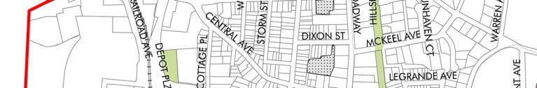
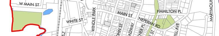
76 Chapter 8: Transportation Figure 8.1 Potential Parking lots in Downtown 8-9
77 Chapter 9: Community Facilities and Services Chapter 9: Community Facilities and Services Goal: Upgrade and expand services and facilities to enhance their function and appearance Objectives: Evaluate the potential for sharing community and educational services with neighboring municipalities Encourage an enhanced role for non-governmental/non-profit entities in the provision of services and provide support to such bodies where feasible The questionnaire distributed in 2004 (by Peter J. Smith) to a total of 5,700 households contained a number of questions in relation to community and government services, the results of which are shown below. Approximately 85 percent of respondents agreed that police, fire, and emergency services were adequate in the Village. TABLE 9-1 Survey Results for Community Facilities and Services Question Strongly Agree Agree No Opinion Disagree Strongly Disagree Police service is adequate in the Village. 29% 57% 9% 4% 1% Fire and Emergency Services are adequate in 32% 53% 12% 3% 0% the Village. Our schools offer a positive learning environment 14% 34% 39% 10% 3% Garbage Collection in the Village meets my needs See appendix for full results of the survey 35% 53% 7% 4% 1% The participants of the June 2006 workshop rated the Community Facilities and Services goal as the least important out of the six draft goals. 9.1 Emergency Services Police The Tarrytown Police Department is located on Depot Plaza and has a total force of forty; thirtyfive full-time law enforcement personnel, and five full-time civilian employees. The Department has an active community policing division which provides bicycle patrols of the business district, reservoir, and Village parks Fire The Tarrytown Fire Department is an entirely voluntary organization that has been serving the Village since the mid 19th Century. It is comprised of six fire companies located throughout the Village, with its headquarters at 50 Main Street. Two new firehouses are proposed on White Plains Road and Meadow Street at Sheldon Avenue. 9-1

78 Chapter 9: Community Facilities and Services Emergency Medical Services Emergency medical services are provided by the Tarrytown Volunteer Ambulance Corps. The Corps is based at 145 Franklin Avenue. 9.2 Library The Warner Library serves both the Villages of Tarrytown and Sleepy Hollow, and is located at 121 North Broadway. The library is a landmarked building. 9.3 Village Hall/Police Station/Court The existing Village Hall, located on Wildey Street, is in need of refurbishment or replacement. As part of the Ferry Landings development agreement, the developer will be constructing affordable housing units on the Village Hall site. The developer will also provide a contribution towards the construction of a new Village Hall and Police Station on Depot Plaza. Site Plan for proposed Village Hall 9.4 Non-Governmental/Non-Profit Services Tarrytown is host to a number of non-profit organizations that provide community services in the Village, including the League of Women Voters, Neighborhood House, the Salvation Army and the Junior League of Westchester-on-Hudson. The Village plays a role in funding such bodies. A study of the services provided, and the ways in which Village funding is spent, would be helpful in determining the best use of available Village resources. 9-2
79 Mount Pleasant Sleepy Hollow k kk John Paulding School k # # & # %, " # j k Fordham University Tarrytown School District Washington Irving School Tappan Hill School k k jhackley School k Transfiguration j School k & Tarrytown Greenburgh Irvington School District Legend Private School Public School Village Hall Police Station Fire House Library Village Boundary COMPREHENSIVE PLAN UPDATE TARRYTOWN FIGURE 9.1: COMMUNITY FACILITIES 0 SOURCE: WESTCHESTER COUNTY GIS 1750 ft
80 Chapter 9: Community Facilities and Services 9.5 Educational Facilities Public Schools Tarrytown is served by two school districts; the Union Free School District of the Tarrytowns, which also serves Sleepy Hollow, and the Irvington Union Free School District. The boundary between these school districts is shown on Figure 9.1. The Tarrytowns District comprises six schools: Sleepy Hollow High School, Sleepy Hollow Middle School, Washington Irving School, Winfield L. Morse School, John Paulding School and Tappan Hill School. Three of these are located in Tarrytown: the Tappan Hill School on Ichabod Lane, John Paulding School on North Broadway and the Washington Irving School on Franklin Street and Broadway. Approximately 35 percent of the school children live in the Village of Tarrytown. The Irvington Union Free School District includes four schools, all of which are located in Irvington. A total of 1,340 school children from Tarrytown attend school in the Irvington District. TABLE 9-2 School Enrollment in Tarrytown District School Grades Total Enrollment 2006/2007 No. of Students from Tarrytown % of Students from Tarrytown Tarrytowns Tappan Hill School Pre-K K % John Paulding School Grade % W.L. Morse School Grades % 3 Washington Irving School Grades % Sleepy Hollow Middle Grades % School 8 Sleepy Hollow High School Grades % 12 Total 2, % Irvington Dows Lane Elementary K % Main Street School Grades % 5 Middle School Grades % 8 High School Grades % 12 Total 1, % TOTAL 4,581 1,340 29% Source: Tarrytowns and Irvington School Districts,


81 Chapter 9: Community Facilities and Services Tappan Hill School Hackley School Private Schools There are two private schools in Tarrytown: the Hackley School which is located on the boundary with Greenburgh, and the Transfiguration School, on Prospect Avenue. Hackley School is a co-educational facility which was founded in 1899 by Mrs. Caleb Brewster Hackley. It is located at 293 Benedict Avenue, with the entrance in Tarrytown, but the bulk of the school property lies in Greenburgh. Hackley is a non-sectarian, co-educational, collegepreparatory school enrolling day students in kindergarten through grade twelve, and five-day boarding students in grades nine through twelve. This facility provides an important resource for Tarrytown and Greenburgh residents, as some of the school s recreational facilities can be used by the local community. The Transfiguration School located on Prospect Avenue is a co-educational, elementary, parochial school. Approximately two-hundred and fifty students are enrolled here Higher Education Marymount College was founded as an independent women's college in 1907 by the Religious of the Sacred Heart of Mary (R.S.H.M.). Early courses at Marymount ranged from courses in domestic science to classes offered in political science and law. In 2002, Marymount officially consolidated with Fordham University, renaming the college as the Marymount College of Fordham University. In 2005, Fordham University announced its plans to close the women's college, effective June 2007, but to keep the campus, which it renamed the Marymount campus, active as a center for graduate studies. Most of the Marymount students will finish their education at the Tarrytown campus, which, in recognition of the College s history and heritage, will permanently be known as the Marymount Campus of Fordham University pending the University's decision of its plans to sell, or keep the property. The Westchester division of the multi-campus Fordham College of Liberal Studies, already housed at the campus, will continue and expand its liberal arts program. Over time, the professional school programs in business administration, social service and education will move 9-5
Comprehensive Plan & Station Area Zoning
 Village of Tarrytown Comprehensive Plan & Station Area Zoning Public Workshop November 5, 2017 Warner Library WXY architecture + urban design Pace University - Land Use Law Center George M. Janes & Associates
Village Gateway at Law Park, with Memorial Plaque to Walter Law. Brick Wall along former Speyer Estate
 2.0 EXISTING CONDITIONS This chapter describes Briarcliff Manor s planning history and physical characteristics. This is necessary background for the land use recommendations in the Village Plan. 2.1 REGIONAL
Planning & Zoning Commission Staff Report
 Planning & Zoning Commission Staff Report Meeting Date: May 26, 2015 Drafted by: Katherine Harrison-Rogers CASE # Z2886 PROJECT NAME: APPLICANT/ REPRESENTATIVE: Shawna Runyan PROPERTY OWNER: 1840 (previously
Secrest Short Cut and Monroe Expressway Small Area Plan AUGUST 29, 2018
 Secrest Short Cut and Monroe Expressway Small Area Plan AUGUST 29, 2018 Background and Process Monroe Expressway will be open by the end of 2018 Union County and Indian Trail identified a need to revisit
The transportation system in a community is an
 7 TRANSPORTATION The transportation system in a community is an important factor contributing to the quality of life of the residents. Without a sound transportation system to bring both goods and patrons
495/MetroWest Development Compact Plan Citizen Planner Training Collaborative Conference. March 17, 2012
 495/MetroWest Development Compact Plan Citizen Planner Training Collaborative Conference March 17, 2012 Project Process Local and Regional Priority Areas Growth Scenarios Transportation Investment Categories
Town of Peru Comprehensive Plan Executive Summary
 Town of Peru Comprehensive Plan Executive Communities that plan grow by choice, not by chance. A plan makes growth thoughtful, understandable, and predictable. A plan shows that a community is managing
SECTION 1 Introduction...1. SECTION 2 Regional Context Criteria for Planning Districts Description of Planning District...
 Table of Contents SECTION 1 Introduction...1 SECTION 2 Regional Context...2 2.1 - Criteria for Planning Districts...2 2.2 - Description of Planning District...2 SECTION 3 Goals & Objectives...5 SECTION
WATERFORD Plan of Preservation, Conservation and Development Supplement Part 1 - Policy Element
 WATERFORD 2012 Plan of Preservation, Conservation and Development 2015 Supplement Part 1 - Policy Element Effective June 11, 2015 2015 Plan Update GOAL To respond to the evolving land use needs and continually
INTRODUCTION PLANNING HISTORY
 INTRODUCTION The Upper Rock Creek Master Plan Area lies in the east central part of Montgomery County. The Master Plan Area is adjacent to the City of Rockville to the south, the Olney Planning Area to
LAND USE MEADOWS PLANNING AREA
 LAND USE MEADOWS PLANNING AREA I. Profile of Meadows Planning Area A. Location Meadows Planning Area is delineated by I-5 on the north, the Nisqually Bluffs representing the growth boundary on the east,
TABLE OF CONTENTS. Transportation Chapter 1 - Introduction and Purpose of Planning to 1-3. Utilities
 Chapter 1 - Introduction and Purpose of Planning... 1-1 to 1-3 Pennsylvania Municipalities Planning Code (Act 247)...1-1 Previous County Planning Activities...1-1 Objectives of the Plan...1-2 Elements
Laberge Group. Town of Coeymans. Draft Comprehensive Plan. Overview of Planning Process
 Draft : Presentation of Goals & Strategies Laberge Group Benjamin H. Syden, A.I.C.P., E.D.P Director in Charge Nicole Allen, A.I.C.P. Senior Planner Anjali Malhotra Planner Presentation Outline Introductions
This page intentionally blank.
 This page intentionally blank. Parks, Recreation, and Open Space Chapter Relationship to Vision Vision Parks, Recreation and Open Space Chapter Concepts County Government. County government that is accountable
Dwelling Units Max 12 dwelling units per acre/min 8 dwelling units per acre. Development Mix 80% non residential/20% residential
 13. OSTEEN LOCAL PLAN Background: The Osteen Local Plan area is located in southwest Volusia County along the SR 415 corridor between Lemon Bluff Road and Acorn Lake Road and includes 3,990 acres. The
Land Use Amendment in Southwood (Ward 11) at and Elbow Drive SW, LOC
 at and Elbow Drive SW, LOC") 2018 November 15 Page 1 of 10 EXECUTIVE SUMMARY This land use amendment application was submitted by Rick Balbi Architect on 2017 August 31 on behalf of Sable Developments Ltd, and with authorization from
2018 November 15 Page 1 of 10 EXECUTIVE SUMMARY This land use amendment application was submitted by Rick Balbi Architect on 2017 August 31 on behalf of Sable Developments Ltd, and with authorization from
AWH REPORT OF THE PLANNING AND DEVELOPMENT DEPARTMENT FOR APPLICATION FOR REZONING ORDINANCE TO PLANNED UNIT DEVELOPMENT
 AWH REPORT OF THE PLANNING AND DEVELOPMENT DEPARTMENT FOR APPLICATION FOR REZONING ORDINANCE TO PLANNED UNIT DEVELOPMENT MAY 8, 2014 The Planning and Development Department hereby forwards to the Planning
PART 1: PROJECT SUMMARY. The application is Attachment A. The site plan is Attachment B.
 Belleterre Subdivision Sketch Plan Town Board 8.7.17 Belleterre Subdivision Sketch Plan PART 1: PROJECT SUMMARY Applicant: Bowman Development Project Size: +/- 20.85 acres Parcel Number: 01115104 and 01115121
Urban Planning and Land Use
 Urban Planning and Land Use 701 North 7 th Street, Room 423 Phone: (913) 573-5750 Kansas City, Kansas 66101 Fax: (913) 573-5796 Email: planninginfo@wycokck.org www.wycokck.org/planning To: From: City Planning
Plan Overview. Manhattan Area 2035 Reflections and Progress. Chapter 1: Introduction. Background
 Plan Overview The Manhattan Urban Area Comprehensive Plan (the Comprehensive Plan) is a joint planning initiative of the City of Manhattan, Pottawatomie County, and Riley County. The 2014 Comprehensive
CITY CLERK. Parkland Acquisition Strategic Directions Report (All Wards)
") CITY CLERK Clause embodied in Report No. 10 of the, as adopted by the Council of the City of Toronto at its meeting held on November 6, 7 and 8, 2001. 10 Parkland Acquisition Strategic Directions Report
CITY CLERK Clause embodied in Report No. 10 of the, as adopted by the Council of the City of Toronto at its meeting held on November 6, 7 and 8, 2001. 10 Parkland Acquisition Strategic Directions Report
Implementation Guide Comprehensive Plan City of Allen
 Implementation Guide 2030 Comprehensive Plan City of Allen DRAFT 2015 Implementation Guide Allen 2030 Comprehensive Plan INTRODUCTION The Comprehensive Plan serves as a guide for the growth and development
Joint Meeting City Council and the Plan Commission. September 1st, 2015
 Joint Meeting City Council and the Plan Commission September 1st, 2015 1 The City Plan Commission shall recommend a City Plan for the physical development of the City Article IX Section 2 of the City of
LAND USE ELEMENT. Purpose. General Goals & Policies
 LAND USE ELEMENT Purpose This Land Use Element contains the goals and policies necessary to support the City s responsibility for managing land resources and guiding development through implementing regulations,
2010 Plan of Conservation and Development
 2010 Plan of Conservation and Development Wilton Planning and Zoning Commission Adopted November 2, 2009 Effective January 1, 2010 WILTON 2010 PLAN OF CONSERVATION & DEVELOPMENT PARTICIPANTS Planning &
Ten Mile Creek Planning Area
 PLANNING AREA POLICIES TEN MILE CREEK Ten Mile Creek Planning Area Location and Context The Ten Mile Creek Planning Area ( Ten Mile Creek area ) is located south of the current Boise AOCI, generally south
This chapter describes the purpose of the Plan, introduces how the Plan is organized and provides contextual background for the Plan.
 Chapter 1: INTRODUCTION Purpose of a Comprehensive Plan The 2040 Comprehensive Plan establishes Medina s vision as a community and sets goals and objectives which guide future decisions and policies. The
CHAPTER 7: VISION AND ACTION STATEMENTS. Noble 2025 Vision Statement
 CHAPTER 7: VISION AND ACTION STATEMENTS This chapter presents the vision, policy and action statements that transform the comprehensive planning study, an analysis of Noble s past, future trends and community
Planning Districts INTRODUCTION
 INTRODUCTION To facilitate detailed examination of development prospects for all areas of the community, Delano has been divided into 14 planning districts. The location of these planning districts is
REQUEST FOR QUALIFICATIONS
 REQUEST FOR QUALIFICATIONS VILLAGE OF HAMBURG COMPREHENSIVE ZONING/LAND USE REGULATIONS UPDATE Prepared By: Village of Hamburg 100 Main Street Hamburg, New York 14075 Village of Hamburg RFQ Page 1 of 10
3. VISION AND GOALS. Vision Statement. Goals, Objectives and Policies
 Vision Statement Queen Creek s interconnected network of parks, trails, open spaces and recreation opportunities provide safe and diverse activities and programs that sustain its unique, small town, equestrian
Comprehensive Plan. Faribault, Minnesota. Hoisington Koegler Group Inc. Claybaugh Preservation Architecture Inc. Howard R. Green Company Bonz/REA
 Comprehensive Plan Faribault, Minnesota Adopted by the Faribault City Council July 8, 2003 prepared for: prepared by: Hoisington Koegler Group Inc. Claybaugh Preservation Architecture Inc. Howard R. Green
{Best Practices. Summary of Tools, Strategies and Best Practices from 11 Michigan Case Study Communities
 Case Studies Michigan Coastal Community Working Waterfronts { Summary of Tools, Strategies and from 11 Michigan Case Study Communities Table of Contents Zoning...2 Community and Stakeholder Collaboration
Baumgarten MPUD. Exhibit 3 Evaluation Criteria
 Pursuant to LDC subsections 10.02.13 B, 10.02.08 F and Chapter 3 G. of the Administrative Code, staff s analysis and recommendation to the Planning Commission, and the Planning Commission s recommendation
3.0 PROJECT DESCRIPTION
 3.0 PROJECT DESCRIPTION 3.1 BACKGROUND Under California law (Government Code Section 65300 et seq.), every city and county is required to have a general plan. The general plan is to be comprehensive and
Somers Point Master Plan
 Somers Point Master Plan Progress Report and Public Meeting August 20, 2014 Master Plan Reexamination Municipal Land Use Law require that all municipalities reexamine their master plan every ten years.
Status Update (2006 vs. Now) Citizen s Advisory Committee February Plan for Prosperity
 Citizen s Advisory Committee February Plan for Prosperity") Status Update (2006 vs. Now) Citizen s Advisory Committee February 2018 Plan for Prosperity 2000 2017 2000 2017 Gardnerville Population 6,000 5,760 5746 5,500 5,000 5,067 5,550 5,165 5,394 5,412 5,250
Status Update (2006 vs. Now) Citizen s Advisory Committee February 2018 Plan for Prosperity 2000 2017 2000 2017 Gardnerville Population 6,000 5,760 5746 5,500 5,000 5,067 5,550 5,165 5,394 5,412 5,250
Urban Development Areas Bedford County
 5 Urban Development Areas Bedford County UDA Needs Profile: All UDAs Bedford County has designated two UDAs: areas just outside the Bedford City Limits (generally to the south and east of the city) and
Executive Summary. NY 7 / NY 2 Corridor
 Executive Summary NY 7 / NY 2 Corridor Transportation and Land Use Study December 2005 Prepared for: Town of Colonie Capital District Transportation Committee Prepared by: Introduction: Land use decisions
CHAPTER 12 IMPLEMENTATION
 CHAPTER 12 IMPLEMENTATION The 2010 Town of Denton Comprehensive Plan is intended to capture a vision of the future of Denton. As such, it provides a basis for a wide variety of public and private actions
EXHIBIT A. Tax Increment Reinvestment Zone No. 1 (Town Center) First Amended Project Plan 1
 First Amended Project Plan 1") EXHIBIT A Tax Increment Reinvestment Zone No. 1 (Town Center) First Amended Project Plan 1 1 As amended by Resolution No. 2008-02-001(TR1R) of the Tax Increment Reinvestment Zone No.1, and approved to
EXHIBIT A Tax Increment Reinvestment Zone No. 1 (Town Center) First Amended Project Plan 1 1 As amended by Resolution No. 2008-02-001(TR1R) of the Tax Increment Reinvestment Zone No.1, and approved to
SECTION ONE: INTRODUCTION. introduction
 introduction 1 INTRODUCTION Since it was first established in 1843 as a trading post for the Hudson s Bay Company, Victoria has evolved into a Provincial capital city that is recognized across Canada and
Danvers High Street I-1 District Study
 Danvers High Street I-1 District Study Presentation of Final Recommendations Planning Board Presentation June 26 th, 2018 1 Introductions Metropolitan Area Planning Council Sam Cleaves AICP, Principal
LAND USE TANGLEWILDE/THOMPSON PLACE PLANNING AREA. C. Identified Neighborhood Groups and Homeowner s Associations
 LAND USE TANGLEWILDE/THOMPSON PLACE PLANNING AREA I. Profile of Tanglewilde/Thompson Place Planning Area (Revised 3/5/02) A. Location The Tanglewilde/Thompson Place Planning Area is located just east of
COLVER ROAD INDUSTRIAL CONCEPT PLAN
 COLVER ROAD INDUSTRIAL CONCEPT PLAN A CONCEPTUAL LAND USE AND TRANSPORTATION PLAN FOR TA-4 AN URBAN RESERVE AREA OF THE CITY TALENT City of Talent Adopted by City Council Resolution No., June, 2015 PART
Sewanee Village + Request for Builder/Developer Proposals
 Sewanee Village + Request for Builder/Developer Proposals Contact: Frank X. Gladu Special Assistant to the Vice Chancellor University of the South 735 University Ave Version 3 Sewanee TN 37383 Released:
CHARLES PUTMAN CHARLES PUTMAN AND ASSOCIATES, INC
 MEMORANDUM CHARLES PUTMAN & ASSOCIATES, INC. LAND DEVELOPMENT CONSULTANTS PLANNING ZONING PERMITTING 4722 NW Boca Raton Boulevard, Suite C-106 Boca Raton, Florida 33431 Phone: 561/994-6411 FAX: 561/994-0447
IMPLEMENTING SOMERSET COUNTY S INVESTMENT FRAMEWORK
 IMPLEMENTING SOMERSET COUNTY S INVESTMENT FRAMEWORK SMART CONSERVATION THROUGH SMART GROWTH NJ LAND CONSERVATION RALLY March 22, 2014 Laurette Kratina, PP, AICP, Supervising Planner Somerset County Planning
IMPLEMENTATION STRATEGIES. In This Chapter. Goals & Strategies 182 Project List 183 Future Land Use 186 CHAPTER 11 IMPLEMENTATION STRATEGIES
 In This Chapter Goals & Strategies 182 Project List 183 Future Land Use 186 11 IMPLEMENTATION STRATEGIES NORTH AUGUSTA, SC 2017 COMPREHENSIVE PLAN 179 Individual commitment to a group effort that is what
CHAPTER 4.0 Community Well-Being
 CHAPTER 4.0 Community Well-Being 4.1 Relationship to our Guiding Principles Community well-being refers to the many factors that contribute to a high quality of life for individuals and the community as
Authority of the General Plan
 Authority of the General Plan This La Habra Heights General Plan will serve as the blueprint for future planning and development in the City. This General Plan describes the City s vision for the future
Mark-up of the effect of the proposed Bronte Village Growth Area OPA No.18 on the text of section 24, Bronte Village, of the Livable Oakville Plan
 Mark-up of the effect of the proposed Bronte Village Growth Area OPA No.18 on the text of section 24, Bronte Village, of the Livable Oakville Plan Notes: This document is provided for information purposes
Staff Report and Recommendation
 Community Planning and Development Planning Services 201 W. Colfax Ave., Dept. 205 Denver, CO 80202 p: 720.865.2915 f: 720.865.3052 www.denvergov.org/cpd TO: City Council Neighborhoods and Planning Committee
Urban Development Areas Frederick County
 18 Urban Development Areas Frederick County UDA Needs Profile: All UDAs Frederick County, Virginia's northernmost county has two UDA s, surrounded by the City of Winchester and located adjacent to the
EXECUTIVE SUMMARY DRAFT CHAPTER 1 INTRODUCTION EXECUTIVE SUMMARY
 CHAPTER 1 EXECUTIVE SUMMARY INTRODUCTION Through the joint efforts of the City of Tulsa planning staff and the Land Services division of Indian Nations Council of Governments (INCOG), the Berryhill Land
CITY OF COLWICH COMPREHENSIVE PLAN LAND USE LAND USE 1
 LAND USE LAND USE 1 WHAT YOU WILL FIND IN THIS CHAPTER: Discussion of today s conditions and tomorrow s projections Discussion of challenges and opportunities Discussion of the environmental quality goals,
Request for Statement of Interest in Implementation of the Roosevelt Road Redevelopment Plan
 425 Hillside Avenue Request for Statement of Interest in Implementation of the Roosevelt Road Redevelopment Plan I. INTRODUCTION The is seeking the services of a qualified consulting firm to prepare plans
2. Form and Character. 2.1 Introduction. 2.2 The Downtown Addition Plan. 2.1 Introduction
 2.1 Introduction 2.1 Introduction This section of the Specific Plan describes and illustrates the desired form, character and uses of the Downtown Addition and explains the underlying design principles.
Asbury Chapel Subdivision Sketch Plan
 Asbury Chapel Subdivision Sketch Plan PART 1: PROJECT SUMMARY Applicant: NVR Inc. Project Size: +/- 76.13 acres Parcel Numbers: 02101112,02116101,02116112, 02116113 Current Zoning: Transitional Residential
CHAPTER 3 VISION, GOALS, & PLANNING PRINCIPLES. City of Greensburg Comprehensive Plan. Introduction. Vision Statement. Growth Management Goals.
 CHAPTER 3 VISION, GOALS, & PLANNING PRINCIPLES Introduction The Greensburg Comprehensive Plan is intended as a working community document. A combination of long and short-term goals, this document is intended
Subject: Hendry County Evaluation and Appraisal Report Letter of Understanding - Identification of Major Issues
 HENDRY COUNTY PLANNING & ZONING DEPARTMENT POST OFFICE BOX 2340 165 S. LEE STREET LABELLE, FLORIDA 33975 (863) 675-5240 FAX: (863) 675-5317 SUNCOM 744-4750 November 16, 2007 Mr. Mike McDaniel, Chief Office
Chapter 13: Implementation Plan
 Implementation A. Introduction The Implementation Plan, in table form on the following pages, provides a summary of all the Action Items recommended in Chapters 2 through 12. The table also indicates which
VILLAGE & TOWN OF BERGEN: COMPREHENSIVE PLAN
 VILLAGE & TOWN OF BERGEN: COMPREHENSIVE PLAN CPC Public Hearing April 21, 2016 History 1996 Comprehensive Plan Comprehensive Plan Update Committee Consultant (LaBella Associates): December 2014 Residents
RECREATION AND OPEN SPACE ELEMENT GOALS, OBJECTIVES, AND POLICIES
 RECREATION AND OPEN SPACE ELEMENT GOALS, OBJECTIVES, AND POLICIES Goal 7 To provide park facilities, recreation programs, and open space resources that are safe, adequate, and accessible to all City residents,
Welcome. Walk Around. Talk to Us. Write Down Your Comments
 Welcome This is an information meeting introducing the applications for proposed redevelopment of the Yorkdale Shopping Centre site at 3401 Dufferin Street and 1 Yorkdale Road over the next 20+ years,
Description of Preferred Alternative
 Chapter 2 Description of Preferred Alternative 2.1 Introduction This chapter of the programmatic Sammamish Town Center Sub-area Plan Final EIS provides a more detailed description of the Preferred Alternative
Mitchell Ranch South MPUD Application for Master Planned Unit Development Approval Project Narrative. Introduction
 Mitchell Ranch South MPUD Application for Master Planned Unit Development Approval Project Narrative Introduction Mitchell Ranch South is a proposed single family (detached) residential development on
GENERAL LAND USE PLAN ELEMENT
 CITY OF Prepared by City of Medford Planning Department 200 South Ivy Street Medford, Oregon 97501 plnmed@ci.medford.or.us James E. Huber, AICP, Planning Director COMPREHENSIVE PLANNING SECTION John Adam,
CHUGIAK-EAGLE RIVER SITE-SPECIFIC LAND USE PLAN
 CHUGIAK-EAGLE RIVER SITE-SPECIFIC LAND USE PLAN JUNE 2010 Final Prepared for The Heritage Land Bank, Municipality of Anchorage by Agnew: :Beck Consulting www.agnewbeck.com 907.222.5424 Chugiak-Eagle River
FUNDING CORRIDOR REVITALIZATION
 FUNDING CORRIDOR REVITALIZATION Integrated corridor planning for the 21 st Century America Planning Association Annual Conference Atlanta, GA April 27, 2014 Mariia Zimmerman, MZ Strategies, LLC mariia@mzstrategies.com
Chapter 10 IMPLEMENTATION RECOMMENDATIONS
 Chapter 10 IMPLEMENTATION RECOMMENDATIONS The recommended land use plan presented in the previous chapter provides a design for the attainment of the urban and rural development and open space preservation
Cumberland Region Tomorrow is a private, non-profit, citizen based regional organization working with Greater Nashville Regional Council
 Cumberland Region Tomorrow is a private, non-profit, citizen based regional organization working with Greater Nashville Regional Council and others in the public and private sectors, dedicated to planning
BROOKLYN PARK / 85TH AVE LRT STATION CDI DEVELOPMENT GUIDELINES DRAFT
 August 2018 Page intentionally left blank The Brooklyn Park Library adjacent to the 85th Ave LRT Station Area. OVERVIEW The Blue Line LRT Extension / Bottineau corridor offers a unique opportunity to leverage
Mill Conversion Overlay District Zoning Bylaw Amendment
 Mill Conversion Overlay District Zoning Bylaw Amendment To see if the Town will vote to amend the Zoning By-Law by adding a new Section 13, Mill Conversion Overlay District, and by amending Sections 2.1,
TOWN COUNCIL / PLANNING COMMISSION
 Workshop #3 TOWN COUNCIL / PLANNING COMMISSION January 20, 2011 Consultant Team In Attendance Tonight BMS Design Group Nevada City and San Francisco Michael Smiley, AICP, ASLA Partner-in-Charge Nancy L.
SECTION II SECTION II STATEMENT OF GOALS, OBJECTIVES, PRINCIPLES, ASSUMPTIONS, POLICIES AND STANDARDS
 STATEMENT OF GOALS, OBJECTIVES, PRINCIPLES, ASSUMPTIONS, POLICIES AND STANDARDS 1 2 STATEMENT OF GOALS, OBJECTIVES, PRINCIPLES, ASSUMPTIONS, POLICIES AND STANDARDS INTRODUCTION The New Jersey Municipal
Gold Line Bus Rapid Transit Transit Oriented Development (BRTOD) Helmo Station Area Plan
 Helmo Station Area Plan") Appendix F Gold Line Bus Rapid Transit Transit Oriented Development (BRTOD) Helmo Station Area Plan Introduction and Purpose of the Plan The Gold Line Bus Rapid Transit facility is an eleven-mile dedicated
Appendix F Gold Line Bus Rapid Transit Transit Oriented Development (BRTOD) Helmo Station Area Plan Introduction and Purpose of the Plan The Gold Line Bus Rapid Transit facility is an eleven-mile dedicated
The Corporation of the TOWN OF MILTON
 Report to: From: Chair & Members of the Administration & Planning Standing Committee W.F. Mann, Director of Planning and Development Date: April 16, 2012 PD 022-12 (Z19/11) Subject: Technical Report Proposed
Introduction. Chapter 1. Purpose of the Comprehensive Plan Plan Organization Planning Process & Community Input 1-1
 Chapter 1 Introduction Lakewood 2025: Moving Forward Together Purpose of the Comprehensive Plan Plan Organization Planning Process & Community Input 1-1 Purpose of the Comprehensive Plan The Comprehensive
Planning Department. Director of Planning. Manager of Planning. Planning Technician/ Sustainability Coordinator. Planner II/ Heritage Coordinator
 Department Director of Manager of Policy Planner Planner II (2) Planner II/ Heritage Coordinator Technician/ Sustainability Coordinator Technician Administrative Clerk March 2017 Department 2018 Business
Stakeholder Recommendations Voting Results
 Stakeholder Recommendations Voting Results Public Input Yes No Abstain Total Count 1. On the matters that are of the highest importance to the community, strengthen the related policy statements through
Tāhuhu whakaruruhau ā-taone The sheltering ridge pole
 B2. Tāhuhu whakaruruhau ā-taone - Urban growth and form B2.1. Issues Tāhuhu whakaruruhau ā-taone The sheltering ridge pole Auckland s growing population increases demand for housing, employment, business,
DISCUSSION TOPIC: ST JOHNS RIVER & ITS TRIBUTARIES (BPII) 2030 COMPREHENSIVE PLAN POLICES AND REGULATORY FRAMEWORK
 2030 COMPREHENSIVE PLAN POLICES AND REGULATORY FRAMEWORK") DISCUSSION TOPIC: ST JOHNS RIVER & ITS TRIBUTARIES (BPII) 2030 COMPREHENSIVE PLAN POLICES AND REGULATORY FRAMEWORK St. John s River & Its Tributaries Issue Summary: The St. Johns River is an important
DISCUSSION TOPIC: ST JOHNS RIVER & ITS TRIBUTARIES (BPII) 2030 COMPREHENSIVE PLAN POLICES AND REGULATORY FRAMEWORK St. John s River & Its Tributaries Issue Summary: The St. Johns River is an important
Hockessin Community Redevelopment Plan
 Hockessin Community Redevelopment Plan 3.1 Introduction The Community Redevelopment Plan for the Village of Hockessin is the result of the people s vision for a distinct village center that serves as the
NEW YORK AND CONNECTICUT SUSTAINABLE COMMUNITIES. Fair Housing & Equity Assessment & Regional Planning Enhancement
 NEW YORK AND CONNECTICUT SUSTAINABLE COMMUNITIES Fair Housing & Equity Assessment & Regional Planning Enhancement November 12, 2013 Yonkers Public Library Federal grant to improve regional planning to
9 CITY OF VAUGHAN OFFICIAL PLAN AMENDMENT NO BOCA EAST INVESTMENTS LIMITED
 9 CITY OF VAUGHAN OFFICIAL PLAN AMENDMENT NO. 631 - BOCA EAST INVESTMENTS LIMITED The Planning and Economic Development Committee recommends the adoption of the recommendations contained in the following
Arlington, Virginia is a worldclass
 EXECUTIVE S U M M A RY Arlington maintains a rich variety of stable neighborhoods, quality schools and enlightened land use policies, and received the Environmental Protection Agency s highest award for
City of Farmington. Downtown Plan. Amendment to the 1998 Master Plan Adopted October 11, 2004
 City of Farmington Amendment to the 1998 Master Plan Adopted October 11, 2004 Introduction Planning Background 1 Scope and Components of the Plan Amendment 2 Concept Introduction 3 Plan Concepts 3 Conceptual
Purpose of the Master Plan
 Purpose of the Master Plan 4 Master Plan Purpose The Master Plan is a policy framework for decisions that affect the physical, social and economic environment of the Town. The Parker 2035: Master Plan
Local Waterfront Revitalization Programs
 Local Waterfront Revitalization Programs Jaime Ethier Coastal Resources Specialist Mid-Hudson Region Supervisor April 27, 2017 April 27, 2017 2 NYS Coastal Area Roughly 1000 feet inland from these waters
VILLAGE OF CLEMMONS PLANNING BOARD DRAFT STAFF REPORT
 VILLAGE OF CLEMMONS PLANNING BOARD DRAFT STAFF REPORT PETITION INFORMATION Docket # C-226 Staff Megan Ledbetter Petitioner(s) JBJH Properties, LLC Owner(s) JBJH Properties, LLC Subject Property 5892-49-1766
Official Plan Review
 Official Plan Review Summary Report - The Built Environment August 2014 Part 1: Introduction Planning for a healthy, prosperous and sustainable community is an important goal for our municipality. From
Introducing the Main Street Strategic Toolbox
 Ulster County Main Streets: A Regional Approach Ulster County Planning Department, 244 Fair Street, Kingston NY 12401 Why do we take a regional approach to Main Streets? There are many different approaches
TREASURE COAST REGIONAL PLANNING COUNCIL M E M O R A N D U M. To: Council Members AGENDA ITEM 5I
 TREASURE COAST REGIONAL PLANNING COUNCIL M E M O R A N D U M To: Council Members AGENDA ITEM 5I From: Date: Subject: Staff December 12, 2008 Council Meeting Local Government Comprehensive Plan Review Town
A Growing Community Rural Settlement Areas
 Town of Huntsville Official Plan Review - POLICY BACKGROUND PAPER A Growing Community Rural Settlement Areas BACKGROUND: In addition to the fully municipally-serviced Urban Settlement Area and the Hidden
DRAFT Amsterdam/Churchill Community Plan (4/17/08) Adopted By the Gallatin County Commission
 Adopted By the Gallatin County Commission") DRAFT Amsterdam/Churchill Community Plan (4/17/08) Adopted By the Gallatin County Commission Table of Contents Acknowledgements Chapter 1: Introduction A Brief History What s Next Authority Organization
DRAFT Amsterdam/Churchill Community Plan (4/17/08) Adopted By the Gallatin County Commission Table of Contents Acknowledgements Chapter 1: Introduction A Brief History What s Next Authority Organization
13 THORNHILL YONGE STREET STUDY IMPLEMENTATION CITY OF VAUGHAN OPA 669 AND TOWN OF MARKHAM OPA 154
 13 THORNHILL YONGE STREET STUDY IMPLEMENTATION CITY OF VAUGHAN OPA 669 AND TOWN OF MARKHAM OPA 154 The Planning and Economic Development Committee recommends the adoption of the recommendations contained
Stakeholders Advisory Working Groups (SAWGs) Smart Growth and TOD Land Use (#11) SAWG Meeting
 Smart Growth and TOD Land Use (#11) SAWG Meeting") Presentation - Part II Tappan Zee Bridge/I-287 Corridor Project July 21, 2010 Slide 1. David Kooris (Regional Plan Association) welcomed members of the Land Use Stakeholders Advisory Working Groups (SAWGs)
Presentation - Part II Tappan Zee Bridge/I-287 Corridor Project July 21, 2010 Slide 1. David Kooris (Regional Plan Association) welcomed members of the Land Use Stakeholders Advisory Working Groups (SAWGs)
4-Town Comprehensive Plan DRAFT 7/30/07
 4-Town Comprehensive Plan DRAFT 7/30/07 Acknowledgements ning Committee Town of Harrisburg Norman Roof Randy Nicol Town of Martinsburg Terry Thisse Paul Kelly Town of Montague Jan Bagdanowicz Wendy Perry
Sustainable Keuka Lake
 Sustainable Keuka Lake Steve Butchko, Town of Wayne Supervisor Chelsea Robertson, Senior Planner STC Kemberli Sargent, Planner STC www.sustainablekeuka.net This presentation was prepared for the New York