Project Title: Landscape Conservation Design in the High Divide. An Analysis of Future Landscape Scenarios and Their Viability Phase 1
|
|
|
- Jason Richards
- 5 years ago
- Views:
Transcription
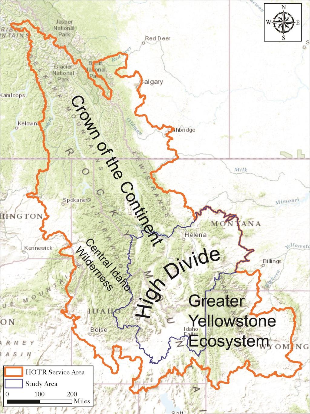
1 Project Title: Landscape Conservation Design in the High Divide. An Analysis of Future Landscape Scenarios and Their Viability Phase 1 Project Coordinator: Michael Whitfield, Coordinator Heart of the Rockies Initiative 1790 E 2000 S, Driggs, ID Michael@heart-of-rockies.org Project PIs: Bray J. Beltrán, Spatial Ecologist Heart of the Rockies Initiative bray@fvlt.org Brent Brock, Wildlife Biologist HoloScene Wildlife Services, LLC brent@holoscenewild.org Ray Rasker, Executive Director Headwaters Economics ray@headwaterseconomics.org High Divide Collaborative Partners (name, affiliation, location): Non-governmental Organizations: Heart of the Rockies Initiative, Driggs, ID Rocky Mountain Elk Fdtn, Missoula, MT Headwaters Economics, Bozeman, MT Vital Ground Foundation, Missoula, MT Bitter Root Land Trust, Hamilton, MT The Nature Conservancy in Montana, Helena, MT The Conservation Fund, Sun Valley, ID ; Missoula, MT Five Valleys Land Trust, Missoula, MT The Nature Conservancy in Idaho, Hailey, ID 83333; Gallatin Valley Land Trust, Bozeman, MT Coeur d Alene, ID Lemhi Regional Land Trust, Salmon, ID Central Idaho Rangeland Network, Salmon, ID Salmon Valley Stewardship, Salmon, ID Wildlife Conservation Society, Bozeman, MT Prickly Pear Land Trust, Helena, MT Greater Yellowstone Coalition, Bozeman, MT Teton Regional Land Trust, Driggs, ID Trout Unlimited, Hailey, ID 83333; Bozeman MT The Trust for Public Land, Bozeman, MT Wolverine Institute, Ennis, MT Wood River Land Trust, Hailey, ID Federal and State Partners: U.S. Forest Service, Region 4 Lands, Ogden, UT 84401; Caribou-Targhee NF, Idaho Falls, ID 83401; Salmon- Challis National Forest, Salmon, ID U.S. Forest Service, Region 1, Lands, Missoula, MT 59807; Beaverhead-Deer Lodge National Forest, Dillon, MT 59725; Gallatin National Forest, Bozeman, MT Bureau of Land Management, Idaho Falls, ID; Dillon, MT; Salmon, ID; Challis, ID U.S. Fish and Wildlife Service, Montana Acquisition Office, Great Falls, MT 59404; Red Rock Lakes National Wildlife Refuge, Lima, MT; National Wildlife Refuge System, Portland, OR National Park Service, Yellowstone National Park, Mammoth, WY; Craters of the Moon National Monument, Arco, ID 83213; Big Hole National Battlefield, Wisdom, MT Natural Resources Conservation Service, ID and MT Idaho Department of Fish and Game, Boise, ID 83712; Idaho Falls, ID 83401; Salmon, ID Montana Department of Fish, Wildlife and Parks, Helena, MT 59620; Bozeman, MT Project Summary: The Heart of the Rockies Initiative (HOTR), on behalf of its High Divide Collaborative partners, seeks support to identify and evaluate future landscape configurations that address the needs of local communities while conserving the High Divide s unique landscape resources. In this landscape we emphasize wildlife connectivity between large protected core areas: Yellowstone, the Crown, and central Idaho (See attached map). This project builds on our prior GNLCC-funded project to 1
2 deliver the latest science in connectivity and climate response and earlier stakeholder identification of lands of high conservation value (HOTR 2010). This project takes the next step by coupling socioeconomic data and trends with conservation modeling in a holistic landscape conservation design process. Project Category: C Applying Science to Management NEED When asked what conservation success looks like, a group of ranchers at the recent (February 2015) High Divide Collaborative Meeting unanimously responded, conservation success is: sustainable working lands; viable, vibrant local communities; and healthy ecosystems across the landscape. One of the biggest challenges for conservation in the High Divide is reconciling the economic needs of the local communities with conservation of wildlife habitats, river corridors, and linkage areas that depend upon both the productive lower elevation private lands and the vast public lands. Different stakeholders have different perspectives and goals for the landscape. Coalescing growth and conservation values in the High Divide will allow for long-term successful coexistence of humans, wildlife, and natural communities under land-use and climate change. We need to evaluate future scenarios to inform on-the-ground decision making, and understand the outcomes management and conservation actions would have on the long-term stability of the system; we need a Landscape Conservation Design. Conservation Design is one of the elements of the US Fish and Wildlife Service Strategic Habitat Conservation Plan (USFWS 2006) where the goal is to assess the ability of landscapes to support populations, and determine the best strategies for attaining desired conservation outcomes. We propose to create future landscape configurations based on stakeholder (e.g. local communities, conservation organizations, agencies) input and evaluate their long-term stability. This evaluation will identify the effects of potential on-the-ground conservation actions on the overall health of the landscape and the projected resilience of local communities. This will allow us to help stakeholders identify which future landscape configuration is more desirable and where conservation actions should be prioritized. At this point conservation practitioners have a limited vision of what long-term conservation success looks like on the ground. We need assessment of probable long-term outcomes for different on-theground actions (e.g county growth policies). Understanding how current decisions affect the viability and long-term stability of the landscape and the communities within it will allow land managers, policy makers, and local communities to evaluate the necessary trade-offs to attain desired future conditions, sustain ecosystem function, and achieve stakeholder goals. We propose to assess current and anticipated future conditions in the High Divide to provide stakeholders with information on the stability of future scenarios and which type of scenario provides a long-term stable state (including development, conserved land, wildlife population conditions, human population growth) in the High Divide. What is the need within the Great Northern landscape? One of the goals of the GNLCC Strategic Conservation Framework is to conserve and sustain a permeable landscape with connectivity across aquatic and terrestrial ecosystems. Privately owned lands in the High Divide play a key role in maintaining connectivity between the large public land blocks in the region. Many public lands are also vital to local community goals and landscape integrity. However, it is not known how much conservation and restoration action is needed in this landscape to avoid the collapse of wildlife populations and maintain genetic connectivity in the face of climate change. We propose to model current and future landscape conditions to evaluate landscape stability under different future scenarios. Understanding the feasibility of different future conditions across the landscape and their long-term stability will help land managers and conservation practitioners understand the pace and scope of conservation action needed to achieve a healthy and thriving landscape. This will also allow local communities to understand what growth policies provide long-term resilience to them and the landscape in general. 2
3 What landscape-level issue is this work related to and how? Why is it important? This project seeks to identify levels of development and human footprint on the High Divide that would maintain a long-term functional landscape that supports local communities and their economy while maintaining permeability for species connectivity between large intact blocks across private lands. The High Divide region provides nationally significant habitat connectivity and landscape integrity. This project will develop models of current conditions (biological and socioeconomic) and model the longterm stability of the landscape. Additionally, this project will model future conditions (biological and socioeconomic) taking into account stakeholder input to assess the viability and stability of those conditions. Based on the stability of the conditions this project will suggest which stressors are most significant to determining future outcomes and which scenarios provide long-term landscape stability and resilience. These scenarios will inform on-the-ground conservation practitioners, land managers, and local communities on desirable futures. These scenarios can catalyze the conversation among stakeholders on how to achieve those desirable futures as well as provide a common goal for all involved. This approach maximizes stakeholder buy-in by integrating important community related values and will be valuable not only for the High Divide, but could then be scaled up or transferred to other regions within the GNLCC. What science products will be provided, problem addressed, or what information or other needs will your project provide? What is the science product or direct management application? This project will produce broad and fine-scale models of current and future conditions taking into account different stakeholder visions for this landscape. Products will include: Predict future changes in water, vegetation, and human development based upon projecting current trends and climate change predictions. Vegetation type distribution models will help us predict response (e.g. Beltan et al. 2014). Develop alternative future development scenarios based on statistical analyses of trends and desired community outcomes. Identify fine-sale conservation priorities based on present and predicted landscape conditions. These models will inform and direct conservation decision making toward long-term community and ecological sustainability. This information can be applied to identify management, restoration, and protection strategies that can be implemented to address the identified resource concerns and obtain the desired future conditions. Is the need identified in other conservation, management, or other plans? The US Fish & Wildlife Service Strategic Habitat Conservation Plan identified gaps in knowledge, and information generation to address those gaps as a critical part of their Strategic Habitat Conservation process. The information generated by addressing the knowledge gap can then be used to inform and refine decision-making. In this proposal we have identified a knowledge gap (lack of understanding of the viability of future conditions in the High Divide) and we plan to produce knowledge that can inform and refine decision-making at the landscape scale to achieve a desirable future with vibrant communities in a healthy landscape. OBJECTIVE What will you accomplish? The goal of this project is to address a lack of knowledge about the sustainability of future landscape conditions created by current policy and conservation decisions. By addressing this knowledge gap we expect to provide an understanding of the cumulative effects of different stressors and decisions and influence decision-making and conservation action. Define how this project will support LCC objectives and functions: The High Divide partners intend to benefit from developing future landscape scenarios to inform conservation and restoration actions in the region. The task at hand is to provide information to stakeholders to guide decision-making and on-the-ground conservation. The High Divide is important both as a stand-alone landscape for fish and wildlife and a vital and vast linkage area of importance to 3
4 function of the entire Great Northern landscape. HOTR will track the effectiveness of this project by monitoring the conservation actions that result and through ongoing engagement of the High Divide Collaborative to refine and adapt conservation decisions to achieve desirable futures. METHODS HOTR will create a spatial assessment of current conditions (biological and socioeconomic) and evaluate the stability of the system. Furthermore, HOTR in collaboration with partners and stakeholders will create future scenarios and evaluate the stability of these to suggest desirable futures with vibrant local communities and a healthy landscape. In this first year, we expect to evaluate scenarios for at least three focal areas within the mapped area. 1. Spatial assessment of current and future conditions a. Biological Conditions (with Holocene Wildlife Services, Wolverine Institute) i. Target groups 1. Intact landscape blocks (public and private) a. Based on Human Modification Index (HMI) (Theobald, 2013) b. Three connectivity scenarios for each time period: i. Montane/Alpine to Montane/Alpine ii. Grassland/Shrub-steppe to Grassland/Shrub-steppe iii. Montane/Alpine to Grassland/Shrub-steppe 2. Focal species (Sage Grouse, Wolverine, Mule Deer, headwaters salmonids) 3. Ecosystem process: i. Natural wildfire and fire mitigation ii. Invasive weeds ii. Map broad-scale core habitat and connectivity needed for species survival and movement (use existing models if possible) iii. Generate fine-scale models of movement pathways and habitat cores within broad-scale linkages based on stressor landscapes. iv. Deliver these products through our existing Conservation Atlas housed on databasin.org b. Socioeconomic Conditions (with Headwaters Economics) i. Current Population levels and trends ii. Population footprint on the landscape. iii. What are the impacts of current population on natural resources (land development [urbanization and energy], and human infrastructure). iv. Current economic conditions and trends of the overall population v. Intersection of current economy and population well-being and natural resources and conservation 2. Desired future conditions (this will be constructed with stakeholder input, e.g. county growth policies, partner workshops) a. Wildlife and human population desired conditions/levels i. Likely human population/land use trends (would inform scenarios tested) ii. Wildlife targets (Sage Grouse, Wolverine, Antelope, Mule Deer) b. Future conditions under different scenarios (climate, stressors influenced by human population) i. Scenario current conditions (baseline inventory and conservation priorities) ii. Scenario X% residential development of existing parcels (no new subdivision) iii. Scenario X% conversion of ranchland to residential (new subdivision scenarios) iv. Scenario Change in land cover and surface water due to climate change 4
5 Landscape resilience to stressors will be evaluated using Monte Carlo simulations. For each stressor, a probability layer will define areas where a given land use/land cover (stressor) change could potentially occur and, where applicable, estimate the probability the change will occur at a given pixel relative to other potential pixels. Multiple computer trials will simulate a given scenario. Scenarios will be based on likely (following current projections) or desired (based on stated community objectives) outcomes. Each trial will measure changes in measures of landscape integrity (e.g. number of linkage pathways, landscape resistance, total core habitat area) compared with a benchmark of current conditions. Mean and variability of change in measures of landscape integrity indicate landscape resilience. Highly resilient landscape will exhibit little or no negative mean change in landscape integrity with low variance while vulnerable landscapes will show an average loss of landscape integrity or have high variability; the latter indicating that outcomes are sensitive to the actual spatial pattern of stressors. Simulations will be run for individual stressors to determine which stressors are likely to be most detrimental to landscape integrity, or in combination to test resilience to cumulative effects. Stakeholder Involvement Stakeholder engagement is vitally important to this project for learning from one another and for community ownership of results. The High Divide Collaborative has established itself as a credible platform for a broad group of stakeholders and is the venue for project engagement. We have formed subcommittees to address landscape scale sage grouse conservation, forest restoration and fire, aquatic resource management, and connectivity for wildlife. Early in the process we will conduct stakeholder workshops to present spatial assessment of current conditions and identify desired future conditions. We will present spatial results and refine analyses through stakeholder engagement in a follow-up workshop in the final months of the project. DELIVERABLES This project will develop future landscape scenarios for use by on-the-ground conservation practitioners, decision-makers, and local communities. The primary deliverables will be GIS data layers of desirable future scenarios and stressor levels acceptable to achieve a resilient landscape under land use and climate change. These layers will be made available to our partners through our existing Conservation Atlas housed on databasin.org. HOTR will provide a final narrative report on the modeling results a year from the initial award date. STATEMENT OF COMPLIANCE HOTR Coordinator Michael Whitfield, and the PI(s) Bray J. Beltrán Brent Brock, and Ray Rasker have read the Great Northern Landscape Conservation Cooperative Information Management, Delivery, and Sharing Standards and agree to comply with those standards if the proposal is selected. Michael Whitfield will direct HOTR employees and/or contractors that are involved in this project to meet these standards. SCHEDULE The project will begin August 2015 and be this Phase I will be completed August Projected Workflow A S O N D J F M A M J J A Identify landscape stressors and species data Spatial assessment of current conditions * Workshops with stakeholders Spatial assessment of future conditions Refine scenarios based on feedback Final Report to GNLCC 5
6 ATTACHEMENTS Key activities/tasks Target date Milestone Comments Identify landscape stressors and August 31, 2015 species data Spatial assessment of current conditions November 1, 2015 Current condition assessment Collaboration with Headwater Stakeholder workshops to identify desired conditions and develop future scenarios Spatial assessment of future conditions Workshop with stakeholders to present spatial assessment of future conditions November 2015 through February, 2016 April 1, 2016 May 1, 2016 completed. Inform and engage stakeholders Complete Spatial Analysis Present desirable futures results Economics Iterative process informed by stakeholders. Stakeholder review Final Narrative report to GNLCC August 1, 2016 Final Report Project completion Citations Beltrán, B.J., J. Franklin, A.D. Syphard, H.M. Regan, L.E. Flint, and A.L. Flint. Effects of Climate Change and Urban Development on the Distribution and Conservation of Vegetation in a Mediterranean Type Ecosystem. International Journal of Geographic Information Science 28 (8): Heart of the Rockies Initiative Connecting the Landscape: A Proposal for Collaborative Conservation in the High Divide Region of Montana and Idaho. 85 pp. plus Appendices Theobald, David M A general model to quantify ecological integrity for landscape assessments and US application. Landscape Ecol (2013) 28: USFWS Strategic Habitat Conservation. Final Report of the National Ecological Assessment Team. 48pp. 6
7 7
INTERMOUNTAIN WEST JOINT VENTURE Strengthening Alliances for Conservation
 INTERMOUNTAIN WEST JOINT VENTURE Strengthening Alliances for Conservation THE PEOPLE OF THE IWJV The people of the Intermountain West are our greatest asset. We, at the IWJV, believe in forging productive,
Collaborative Conservation across Landscapes: Experiences from the Upper Midwest and Great Lakes LCC 2/29/2016. GreatLakesLCC.org
 Collaborative Conservation across Landscapes: Experiences from the Upper Midwest and Great Lakes LCC 2/29/2016 GreatLakesLCC.org Personal introduction Brad Potter - Science Coordinator for the Upper Midwest
1.16 million KM 2 5 States, 2 Provinces Integrated Partnerships with neighboring LCCs, NW and NC Climate Science Centers, PNW
 GNLCC Goal: Coordinate, facilitate, promote and add value to large landscape conservation to build resource resilience in the face of climate change and other landscape level stressors through: Support
Category for Proposal: Partner Forums
 Project Title: Strategic conservation planning for management applications in Cascadia. Project Coordinator: Jen Watkins (Conservation Northwest, jwatkins@conservationnw.org) Project PIs: Cascadia Partner
Photo by Carlton Ward Jr. Executive Summary
 Photo by Carlton Ward Jr. Executive Summary The Cooperative Conservation Blueprint (Blueprint) is a multi-partner strategic conservation process developed by the Florida Fish and Wildlife Commission (FWC)
Next steps Vision and Mission Science Priorities Objective Conservation Framework Actions
 Vision: A conservation community, that while governed by their unique purposes and missions, collaborates on sustaining lands and waters that support natural and cultural resources and the services they
BLM s Landscape Approach
 s Landscape Approach s Landscape Approach Conservation Planning in Nevada January 14, 2013 John M Wilson Healthy Landscapes Program Lead, Nevada Purpose of Today s Discussion Provide an overview of the
Road Ecology in Practice: Building Resiliency of Urban Ecosystems through Informed Road Network Planning
 Road Ecology in Practice: Building Resiliency of Urban Ecosystems through Informed Road Network Planning Outline What is road ecology? Why is road ecology important? TRCA and road ecology application Peel
Wide-ranging Species Conservation
 Wide-ranging Species Conservation The overwhelming message from population viability studies of large carnivores is that conservation planning must be undertaken at vast spatial scales and must consider
Aquatic, Terrestrial and Landscape Conservation Design Tools and Products of the North Atlantic LCC
 Aquatic, Terrestrial and Landscape Conservation Design Tools and Products of the North Atlantic LCC Scott Schwenk Science Coordinator, North Atlantic LCC Chesapeake Bay FWS Partners Meeting Annapolis,
ANNUAL REPORT. GREAT NORTHERN Landscape Conservation Cooperative
 GREAT NORTHERN Landscape Conservation Cooperative 2015 ANNUAL REPORT LANDSCAPE CONSERVATION COOPERATIVE Aspen forests are high-value habitat in the Centennial Mountains, which is an important wildlife
Member Service Plan Sierra Nevada AmeriCorps Partnership
 Member Service Plan Sierra Nevada AmeriCorps Partnership Service plans lay the framework for what each Member will be doing during their service. Service plans detail the major projects and expected results
Monitoring for Ecological Integrity and State of the Parks Reporting
 Monitoring for Ecological Integrity and State of the Parks Reporting Donald McLennan 1 and Paul Zorn 1 National Monitoring Biologist Parks Canada, Ecological Integrity Branch 25 Eddy Street Gatineau, Québec,
systems is available on the Colorado Wetland Information Center (CWIC) website.
 website.") Colorado Natural Heritage Program Wetland Program Plan -- Dec 2015 Status Update and Addendum -- The Colorado Natural Heritage Program (CNHP) developed a Wetland Program Plan (WPP) in 2010 for the planning
Colorado Natural Heritage Program Wetland Program Plan -- Dec 2015 Status Update and Addendum -- The Colorado Natural Heritage Program (CNHP) developed a Wetland Program Plan (WPP) in 2010 for the planning
Big Picture Protected Areas Strategy Collaborating to Protect and Conserve Nature in Ontario s Carolinian Zone
 Big Picture Protected Areas Strategy Collaborating to Protect and Conserve Nature in Ontario s Carolinian Zone Jarmo Jalava Protected Areas Consultant Carolinian Canada Coalition National Workshop October
Colorado Outdoor Partnership
 Colorado Outdoor Partnership Quick Facts 2017 SHIFT Award Winner Public Land Management Innovation Category Year Founded: 2016 Member agencies and organizations: 32 Executive Summit Coalition The Problem:
Great Northern LCC. Five years ago, the Great Northern Landscape Conservation Cooperative. Activities & Accomplishments. Vision
 LANDSCAPE CONSERVATION COOPERATIVE Great Northern LCC Activities & Accomplishments 2014 Together, community members landowners, businesses, organizations, and agencies in the rural Salmon River Valley
Blue/Green Infrastructure Study Accomack County, VA
 Blue/Green Infrastructure Study Accomack County, VA Draft Asset Maps March 8-9, 2010 Green Infrastructure Center, Inc. 2 Overview What is Green and Blue Infrastructure Project Timeline & Tasks Literature
WELCOME! Four Corners and Upper Rio Grande Vulnerability Assessment Webinar Series
 WELCOME! Four Corners and Upper Rio Grande Vulnerability Assessment Webinar Series Phone audio: Dial: 866-620-8138; Passcode: 5952203# Mute your phone and turn off computer speakers (prevents echo issue).
Northeast Conservation
 Northeast Conservation Framework What is it and why do we need it? National LCC Workshop Denver CO March 2012 Northeast Conservation Framework History Context Future NA Landscape Conservation Cooperative
Scope of Services. River Oaks Boulevard (SH 183) Corridor Master Plan
 Corridor Master Plan") Scope of Services River Oaks Boulevard (SH 183) Corridor Master Plan PROJECT AREA The project area consists of the River Oaks Boulevard (SH 183) corridor bounded by SH 199 at the northern end and the Trinity
Scope of Services River Oaks Boulevard (SH 183) Corridor Master Plan PROJECT AREA The project area consists of the River Oaks Boulevard (SH 183) corridor bounded by SH 199 at the northern end and the Trinity
INTEGRATING PROTECTED AREAS INTO THE WIDER LANDSCAPE, SEASCAPE AND RELATED SECTORS. An Overview
 INTEGRATING PROTECTED AREAS INTO THE WIDER LANDSCAPE, SEASCAPE AND RELATED SECTORS An Overview USING AN EXAMPLE FROM NORTHEAST US Relationship of IPAWLS guide to other planning and assessment processes
2014 South Atlantic LCC
 2014 South Atlantic LCC Annual Report 1 Allie Stewart, U.S. FWS The South Atlantic LCC s 2014 Annual Report this year of progress and accomplishments is dedicated to South Atlantic LCC Coordinator, Ken
California Landscape Conservation Cooperative
 californialcc.org California Landscape Conservation Cooperative Debra Schlafmann, Coordinator October 19, 2016 Landscape Conservation Cooperatives There are 22 LCCs http://lccnetwork.org/ LCC Map Landscape
ROLE OF LANDSCAPE CONSERVATION COOPERATIVES IN EVERGLADES RESTORATION
 ROLE OF LANDSCAPE CONSERVATION COOPERATIVES IN EVERGLADES RESTORATION GEER April 2017 Steve Traxler 1, Todd Hopkins 1, Beth Stys 2 1 US Fish and Wildlife Service 2 Florida Fish & Wildlife Conservation
Biodiversity Action Plan Background Information for discussion purposes
 Biodiversity Action Plan Background Information for discussion purposes Our commitment As directed by Council, The City of Calgary has agreed to sign the Durban Commitment, an international agreement on
Peninsular Florida Landscape Conservation Cooperative. Marine and Estuarine Priority Resources and Conservation Targets
 Peninsular Florida Landscape Conservation Cooperative Marine and Estuarine Priority Resources and Conservation Targets Why are we here today? Workshop Goals: Develop a list of potential conservation targets
Getting Ahead of Climate Change Land trusts taking the lead on climate change
 Getting Ahead of Climate Change Land trusts taking the lead on climate change 2017 Rally, Denver, CO Abigail Weinberg Director of Research Open Space Institute 1 Land and Climate Initiative Goals 1. Increase
NORTHERN LANDS NORTHERN LEADERSHIP
 NORTHERN LANDS NORTHERN LEADERSHIP The GNWT Land Use and Sustainability Framework Our Lands, Our Interests, Our Future ii Land is Life MESSAGE FROM THE PREMIER Land is life. It is the link to our past.
4. What are the goals of the Kawarthas, Naturally Connected project? 7. What are watersheds and why are they being used as the project boundaries?
 Frequently Asked Questions (FAQs) 1. What are Natural Heritage Systems (NHS)? 2. Why are they important? 3. Which areas of the province have undertaken NHS projects? 4. What are the goals of the Kawarthas,
Community Conservation Workshop. Lake Placid
 Community Conservation Workshop Lake Placid 2 Community Conservation Program Welcome! We have designed a Community Conservation Program that listens to the needs of community members. We are conducting
Describing the Integrated Land Management Approach
 Describing the Integrated Land Management Approach ISBN No. 978-0-7785-8902-0 (Online Edition) Pub No. I/422 What is Integrated Land Management? Integrated land management (ILM) is the strategic, planned
ARISE: The Rock Renaissance Area Redevelopment & Implementation Strategy
 2014 Professional Awards 1 ARISE: The Rock Renaissance Area Redevelopment & Implementation Strategy Janesville, WI Completed December 2014 Analysis & Planning Purpose of Project 2 The purpose of the Rock
NJ Habitat Connectivity Initiative
 NJ Habitat Connectivity Initiative Full Working Group Update #1 Spotted Salamander Crossing Road in Northern NJ Wildlife Habitat Connectivity Initiative A strategic plan to reconnect New Jersey s landscape
Arlington, Virginia is a worldclass
 EXECUTIVE S U M M A RY Arlington maintains a rich variety of stable neighborhoods, quality schools and enlightened land use policies, and received the Environmental Protection Agency s highest award for
2011 ASLA Design Awards. Westside Creeks Restoration Plan Merit Award AECOM, Fort Collins. Planning & Urban Design
 2011 ASLA Design Awards Westside Creeks Restoration Plan Merit Award AECOM, Fort Collins Planning & Urban Design Project Fact Sheet Category of Entry: Rotating Specialty Award: 2011 2011 ASLA Colorado
BRE Strategic Ecological Framework LI Technical Information Note 03/2016
 BRE Strategic Ecological Framework Technical Information Note 03/2016 September 2016 Contents 1. Introduction 2. Aims of BRE s Strategic Ecological Framework 3. How SEF is different from previous approaches
New Tools for Land Management: A Quick Introduction to Ecological Site Descriptions
 New Tools for Land : A Quick Introduction to Ecological Site Descriptions Land management agencies have the job of managing natural resources for multiple uses in a sustainable manner. A sound understanding
SUSTAINABILITY PLAN OTTAWA COUNTY PARKS AND RECREATION COMMISSION FALL 2017
 SUSTAINABILITY PLAN OTTAWA COUNTY PARKS AND RECREATION COMMISSION FALL 2017 Table of Contents Introduction Natural Resources Quality of Life Community Continuing the Mission Sustainability Measuring Sustainability
2040 LUP is a part of the Comprehensive Plan and carries the same legal authority. Economic Challenges
 1.1. Guiding Anchorage s Growth Where will new residents settle over the next two decades? Where will people work, shop, and play? Will there be enough room to grow? How will Anchorage look? Will growth
SAN RAFAEL GENERAL PLAN 2040 INTRODUCTION AND OVERVIEW
 SAN RAFAEL GENERAL PLAN 2040 INTRODUCTION AND OVERVIEW Steering Committee Presentation February 14, 2018 Purpose of General Plan Guide land use and development decisions Coordinate transportation, infrastructure,
Wildlife Habitat Information as the Foundation of Land Development Regulations. The Local Perspective. RMLUI March 9, 2018
 Wildlife Habitat Information as the Foundation of Land Development Regulations The Local Perspective RMLUI March 9, 2018 EcoConnect Consulting LLC Connecting Ecology and Community Megan A Smith, Owner/
A Delta Renewed: A Guide to Science Based Ecological Restoration in the Delta
 A Delta Renewed: A Guide to Science Based Ecological Restoration in the Delta J. Letitia Grenier, San Francisco Estuary Institute, letitia@sfei.org Julie Beagle, San Francisco Estuary Institute, julieb@sfei.org
Call for Artists for: Design and Construction of Environmental Art Activation Story Mill Community Park, Bozeman, MT
 Call for Artists for: Design and Construction of Environmental Art Activation Story Mill Community Park, Bozeman, MT Seeking artists to design, fabricate and install art elements in the nature sanctuary
Community Conservation Workshop. Saranac River Basin Communities
 Community Conservation Workshop Saranac River Basin Communities 2 Community Conservation Program Welcome! We have designed a Community Conservation Program that listens to the needs of community members.
An Ambitious Plan: Transforming the blighted South Platte River and surrounding environment into Denver s greatest natural resource.
 CONNECTING THE PEOPLE TO THEIR RIVER SOUTH PLATTE RIVER VISION IMPLEMENTATION PROGRAM: GRANT-FRONTIER PARK TO OVERLAND POND PARK REACH The South Platte River Vision Implementation Program (River Vision)
An Introduction to the Far North Land Use Strategy
 An Introduction to the Far North Land Use Strategy December, 2013 Ministry of Natural Resources Table of Contents PREFACE... 3 About the Far North... 3 Evolution of Land Use Planning in the Far North...
for Biosphere Reserves
 Sustainable Tourism in Biosphere Reserves in Central and Eastern Europe Tourism Management Plans for Biosphere Reserves Ecological Tourism in Europe - E.T.E. e.v. Page 1 What is a Tourism Management Plan?
Consolidated Workshop Proceedings Report
 Consolidated Workshop Proceedings Report Regional Workshop on Urban Risk Damascus, Syria, November 4. 5. 2009 UNISDR, the Global Facility for Disaster and Recovery (GFDRR) of the World Bank, UNDP Syria
Land Use Regional Planning in Alberta Collaborating with Stakeholders
 Land Use Regional Planning in Alberta Collaborating with Stakeholders Trevor Lema, Land & Integrated Management Planner September 2018 Overview Why Regional Planning? An Integrated Perspective Integrated
STEWARDSHIP OF LONG ISLAND SOUND S ECOLOGICAL AND RECREATIONAL RESOURCES
 STEWARDSHIP OF LONG ISLAND SOUND S ECOLOGICAL AND RECREATIONAL RESOURCES Robin Kriesberg, Save the Sound, Inc. Thomas Halavik, US Fish and Wildlife Service Coastal Program An Initiative to Identify, Protect
Conservation by Design: Promoting Resilient Coastal Wetlands & Communities. GreatLakesLCC.org
 Conservation by Design: Promoting Resilient Coastal Wetlands & Communities Brent Schleck The Baldwin Group - NOAA Office for Coastal Management ASFPM 6/22/16 GreatLakesLCC.org Overview 2 Great Lakes coastal
CHAPTER 1 Introduction
 CHAPTER 1 Introduction From sea to summit, Lane County covers almost 4,800 square miles of diverse Oregon landscape. Stretching from the Pacific Ocean through the Coastal Range, the Willamette Valley to
Middle Mississippi River. Regional Corridor
 Middle Mississippi River St. Louis District Regional Corridor Lessons Learned from a Collaborative Planning Study Brian Johnson US Army Corps of Engineers 12 th Biennial Governor s Conference on the Management
CITY OF VAUGHAN EXTRACT FROM COUNCIL MEETING MINUTES OF NOVEMBER 15, 2016
 Item 11, Report No. 38, of the Committee of the Whole, which was adopted without amendment by the Council of the City of Vaughan on November 15, 2016. Regional Councillor Di Biase declared an interest
National Association of Conservation Districts. Kris Hoellen Vice President, Sustainable Programs The Conservation Fund September 19, 2013
 National Association of Conservation Districts Kris Hoellen Vice President, Sustainable Programs The Conservation Fund September 19, 2013 Our Mission The Conservation Fund forges partnerships to conserve
Potential Solutions to Transportation-Wildlife Conflicts An Overview. Tony Clevenger WTI Montana State University
 Potential Solutions to Transportation-Wildlife Conflicts An Overview Tony Clevenger WTI Montana State University Effects on wildlife Habitat loss Wildlife mortality Decrease habitat quality Habitat fragmentation
Public Review Draft Oceanside Subarea Habitat Conservation Plan/ Natural Communities Conservation Plan
 Oceanside Subarea Habitat Conservation Plan/ Natural Communities Conservation Plan Prepared for City of Oceanside Planning Department 300 N. Coast Highway Oceanside, CA 92054 Prepared by Ogden Environmental
Smart Growth for Dallas
 Smart Growth for Dallas Data-driven decisions for the future of Dallas parks, open spaces, and green infrastructure Dallas Park and Recreation Board March 10, 2016 Agenda I. Welcome and Introductions II.
Arkansas River Corridor
 Planning for Access Welcome to the Access Project. This project is a recreational planning effort in response to an interest by regional communities along the Arkansas River corridor. The project plan
Large Landscape Restoration and the National Park System
 National Park Service U.S. Department of the Interior Large Landscape Restoration and the National Park System April 21, 2016 National Conference on Ecosystem Restoration Raymond M. Sauvajot, Ph.D. Associate
COASTAL CONSERVANCY. Staff Recommendation March 25, 2004 LOS ANGELES GREEN VISION PLAN. File No.: Project Manager: Marc Beyeler
 COASTAL CONSERVANCY Staff Recommendation March 25, 2004 File No.: 04-014 Project Manager: Marc Beyeler RECOMMENDED ACTION: Authorization to disburse up to $50,000 to the University of Southern California
Green Infrastructure Planning for Sustainability and Resiliency
 Green Infrastructure Planning for Sustainability and Resiliency Linking Lands and Communities in the Land-of-Sky Region SAMAB Conference - November 18, 2010 www.linkinglands.org Linda Giltz, AICP, Regional
Managing our Landscapes Conversations for Change
 Managing our Landscapes Conversations for Change Frequently Asked Questions The new State Government is committed to a significant reform program that will change the way natural resources are managed.
The Five Components of the McLoughlin Area Plan
 The Five Components of the McLoughlin Area Plan This documents contains the complete language of the five components of the McLoughlin Area Plan: The Vision Statement The Values The Guiding Principles
Natural Environment White Paper & new partnerships to deliver green infrastructure. Henry Smith, Project and Policy Assistant, TCPA
 Natural Environment White Paper & new partnerships to deliver green infrastructure Henry Smith, Project and Policy Assistant, TCPA Presentation outline 1) Green Infrastructure introduction The TCPA s work
Lower Columbia River and Coastal Landscape Conservation Design
 Today s Presenters: Lower Columbia River and Coastal Landscape Conservation Design John Mankowski, North Pacific Landscape Conservation Cooperative Sara Evans-Peters, Pacific Birds Tom Miewald, US Fish
Welcome to the Oakridge Centre Open House
 Welcome to the Oakridge Centre Open House Why is the City hosting this event? This open house is to inform you of a rezoning application submitted to the City of Vancouver to amend the existing CD-1 (Comprehensive
This page intentionally blank.
 This page intentionally blank. Parks, Recreation, and Open Space Chapter Relationship to Vision Vision Parks, Recreation and Open Space Chapter Concepts County Government. County government that is accountable
Western Pennsylvania Conservancy Clairton & Harrison Community Greening Assessment Projects Request for Proposals July 2018
 Western Pennsylvania Conservancy Clairton & Harrison Community Greening Assessment Projects Request for Proposals July 2018 Proposal Information The Western Pennsylvania Conservancy (WPC) is seeking proposals
Alternative Routes. St. Vital to La Verendrye Station - Southern Loop Transmission Corridor. 20 different segments 4 segments common to all routes
 Alternative Routes St. Vital to La Verendrye Station - Southern Loop Transmission Corridor In a fixed right-of-way St. Vital to Letellier Station 20 different segments 4 segments common to all routes Goal
Table of Contents TABLE OF CONTENTS SECTION TITLE PAGE
 TABLE OF CONTENTS SECTION TITLE PAGE 1 INTRODUCTION AND OVERVIEW 1-1 1.1 Purpose and Need 1-1 1.2 Goals and Objectives 1-3 1.3 Overview of the Planning Process 1-5 1.4 Federal and State Requirements and
Citywide Integrated Stormwater Management Plan (ISMP) DRAFT ACTION PLAN REVIEW Public Consultation November 16 th, 2016
 DRAFT ACTION PLAN REVIEW Public Consultation November 16 th, 2016") Citywide Integrated Stormwater Management Plan (ISMP) DRAFT ACTION PLAN REVIEW Public Consultation November 16 th, 2016 1 Agenda DRAFT ACTION PLAN REVIEW Public Consultation Time 6:00 6:05 6:05 6:20 6:20
Citywide Integrated Stormwater Management Plan (ISMP) DRAFT ACTION PLAN REVIEW Public Consultation November 16 th, 2016 1 Agenda DRAFT ACTION PLAN REVIEW Public Consultation Time 6:00 6:05 6:05 6:20 6:20
IMPLEMENTING SOMERSET COUNTY S INVESTMENT FRAMEWORK
 IMPLEMENTING SOMERSET COUNTY S INVESTMENT FRAMEWORK SMART CONSERVATION THROUGH SMART GROWTH NJ LAND CONSERVATION RALLY March 22, 2014 Laurette Kratina, PP, AICP, Supervising Planner Somerset County Planning
National Park Service U.S. Department of the Interior. Climate Change Response and Cultural Landscape Preservation
 Climate Change Response and Cultural Landscape Preservation National Park Service Climate Change Response Strategy (Sept. 2010) Preserving the Nation s Heritage The preservation and protection of cultural
The Conservation Fund The Center for Conservation and Development
 The Conservation Fund The Center for Conservation and Development Partners in Land and Water Conservation Smart Growth and Sustainable Ranges August 23, 2004 Savannah, GA The Conservation Fund--8/23/04
Key Elements of Successful Conservation Planning. John Paskus October 17, 2013 Pierce Cedar Creek Institute Michigan Natural Features Inventory
 Key Elements of Successful Conservation Planning John Paskus October 17, 2013 Pierce Cedar Creek Institute Michigan Natural Features Inventory What is Conservation Planning? Pressey et al (2008): The process
Consolidated Workshop Proceedings Report
 United Nations International Strategy for Disaster Reduction Regional Office for Arab States THE WORLD BANK Syrian Ministry of Local Administration Consolidated Workshop Proceedings Report Regional Workshop
COLORADO S Comprehensive Wildlife Conservation Strategy Linking Conservation and Transportation Planning August 15, 2006
 COLORADO S Comprehensive Wildlife Conservation Strategy Linking Conservation and Transportation Planning August 15, 2006 The Input Process Input from DOW experts List of scientific experts Mailing to 1000
Overview of Southwestern Pennsylvania Commission s (SPC) 2040 Long Range Transportation Plan (LRTP)
 2040 Long Range Transportation Plan (LRTP)") Overview of Southwestern Pennsylvania Commission s (SPC) 2040 Long Range Transportation Plan (LRTP) Presented to Pennsylvania Agency Coordination Meeting May 27, 2015 Doug Smith & Ryan Gordon 1 Southwestern
Overview of Southwestern Pennsylvania Commission s (SPC) 2040 Long Range Transportation Plan (LRTP) Presented to Pennsylvania Agency Coordination Meeting May 27, 2015 Doug Smith & Ryan Gordon 1 Southwestern
Protected Areas: Context for Planning and Management Parks Canada Perspective
 Protected Areas: Context for Planning and Management Parks Canada Perspective Mark Yeates 1 and Paul Zorn 1 A/Manager, Ecosystem Conservation Parks Canada, Ontario Service Centre 111 Water Street East
Recent Progress on Wildlife Corridor and Ecological Connectivity Policy in the United States By Robert Ament Senior Conservationist
 Recent Progress on Wildlife Corridor and Ecological Connectivity Policy in the United States 2007-2010 By Robert Ament Senior Conservationist January, 2011 INTRODUCTION This report summarizes the increasing
Position Description Sierra Nevada AmeriCorps Partnership
 SNAP Position Description 2016/2017 Position Description Sierra Nevada AmeriCorps Partnership Position Title: Education Coordinator Host Site: Eastern Sierra Land Trust Site Supervisor: Kay Ogden, Executive
Executive Summary. Essential Connectivity Map (Figure ES-1)
") Executive Summary The California Department of Transportation (Caltrans) and California Department of Fish and Game (CDFG) commissioned the because a functional network of connected wildlands is essential
Executive Summary The California Department of Transportation (Caltrans) and California Department of Fish and Game (CDFG) commissioned the because a functional network of connected wildlands is essential
Town of Oakville Streetscape Strategy
 Town of Oakville Streetscape Strategy Endorsed by PDC on February 10, 2014 (PD-011-14) Town of Oakville Streetscape Strategy [endorsed by PDC February 10, 2014] 0 Town of Oakville Streetscape Strategy
building with nature - a new benchmark for green infrastructure
 building with nature - a new benchmark for green infrastructure Danielle Sinnett, Gemma Jerome, Sarah Burgess, Nick Smith and Roger Mortlock outline the aims, development and proposed operation of Building
DRAFT FOR PUBLIC REVIEW. Game Plan for a Healthy City
 DRAFT FOR PUBLIC REVIEW 2018 Game Plan for a Healthy City 2 Denveright. Parks & Recreation Game Plan Draft for Public Review Draft for Public Review Executive Summary Game Plan Overview Executive Summary
CITY OF CHARLOTTESVILLE, VIRGINIA CITY COUNCIL AGENDA
 CITY OF CHARLOTTESVILLE, VIRGINIA CITY COUNCIL AGENDA Agenda Date: December 16, 2013 Action Required: Adoption of Resolution Presenter: Staff Contacts: Title: James E. Tolbert, AICP, Director of NDS James
RECREATION, OPEN SPACE AND GREENWAYS ELEMENT GOALS, OBJECTIVES, AND POLICIES
 RECREATION, OPEN SPACE AND GREENWAYS ELEMENT GOALS, OBJECTIVES, AND POLICIES GOAL R-1: DEVELOP A RECREATION, OPEN SPACE AND GREENWAYS SYSTEM AS AN INTEGRAL COMPONENT OF AN OVERALL, COUNTY-WIDE ECONOMIC
Smart City Governance URBIS Solutions. David Ludlow, Assoc. Professor European Smart Cities University of the West of England, Bristol
 Smart City Governance URBIS Solutions David Ludlow, Assoc. Professor European Smart Cities University of the West of England, Bristol Integrated smart city model Smart Mobility Services focused on decreasing
LANDSCAPE SCALE PLANNING AND SITING FOR SHALE DEVELOPMENT
 LANDSCAPE SCALE PLANNING AND SITING FOR SHALE DEVELOPMENT An Energy by Design approach to reducing the overall environmental footprint. MICHELLE MCGREGOR SR. OIL & GAS DEVELOPMENT ADVISOR Agenda Introduction
Landscape Conservation Design April, 2014
 Designing Sustainable Landscapes in the Northeast A project of the North Atlantic Landscape Conservation Cooperative & Northeast Climate Science Center Landscape Conservation Design April, 2014 Conceptual
Arctic Council s WG PAME
 Arctic Council s WG PAME Arctic Resilience Forum Meeting 10-11 September 2018 Rovaniemi, Finland Selected PAME projects that involve collaboration and point to effective practices for building resilience
Preparing to Review City-owned Property
 Preparing to Review City-owned Property June 28, 2017 WORKING DRAFT Prepared for: Mayor DeBoer and the Holland City Council Prepared by: Denny Ellens William J. Johnson Soren Wolff Phil Meyer REPORT CONTENTS
FAQ S about Restoration Planning FROM THE Department of Ecology WEBSITE:
 FAQ S about Restoration Planning FROM THE Department of Ecology WEBSITE: http://www.ecy.wa.gov/programs/sea/sma/st_guide/smp/restoration/qanda.html Notations in parentheses are staff notes directing you
WELCOME TO THE CHOUTEAU GREENWAY EQUITY WORKING GROUP!
 WELCOME TO THE CHOUTEAU GREENWAY EQUITY WORKING GROUP! Chouteau Greenway Steering Committee and Working Groups Overview Overview January 9, 2019 Chouteau Greenway will transform St. Louis by connecting
Public Review Draft Encinitas Subarea Plan
 Encinitas Subarea Plan Prepared for City of Encinitas Community Development Department 505 S. Vulcan Encinitas, California 92024 Prepared by Ogden Environmental and Energy Services Co., Inc. 5510 Morehouse
2011 ASLA Design Awards. Top of the Rockies National Scenic and Historic Byway Merit Award Bluegreen. Planning & Urban Design
 2011 ASLA Design Awards Top of the Rockies National Scenic and Historic Byway Merit Award Bluegreen Planning & Urban Design ASLA Colorado 2011 Design Awards Category 2: Planning Project Fact Sheet Project
Landscape Conservation Design June, 2014
 Designing Sustainable Landscapes in the Northeast A project of the North Atlantic Landscape Conservation Cooperative & Northeast Climate Science Center June, 2014 Adaptive Establish Conservation Goals
Objectives and Strategies for the Integration of Recreation, Parks and Open Space in Regional Plans
 BULLETIN 2 Objectives and Strategies for the Integration of Recreation, Parks and Open Space in Regional Plans TABLE OF CONTENTS Introduction 3 Land-use Framework Outcomes 1 4-8 Land-use Framework Outcomes