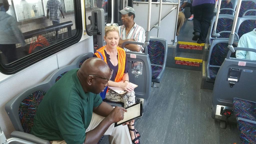
joint initiative of SHOW ME: COMPLETE STREETS IMPLEMENTATION AND ENGAGING INFLUENCERS TROY J. BROUSSARD, AARP LOUISIANA
|
|
|
- Douglas Ashley Mason
- 5 years ago
- Views:
Transcription
1 joint initiative of SHOW ME: COMPLETE STREETS IMPLEMENTATION AND ENGAGING INFLUENCERS TROY J. BROUSSARD, AARP LOUISIANA
2 STAC members: David Aguillard, Catholic Charities of Diocese of BR Andy Allen Logan Anderson, BRAC Coletta Barrett, OLOL Regional Medical Center Peter Breaux, Ph.D., Southern University of BR Ashley Bridges, American Heart Association Rex Cabaniss, WHLC Architecture Jeffrey Campbell, Louisiana State University Donna Collins-Lewis, BR Metro Council, District 6 Emmett Crockett, CATS Juan Cruz, Gardere Initiative Nancy Curry, Federation of GBR Civic Assoc. Eric Dexter, Civil Solutions Consulting Group, Inc. Rachel DiResto, Center for Planning Excellence Jeanne George, Ph.D., AARP, LA Volunteer Exec. Council Yuwen Hou Jared Hymowitz, Healthy BR Sam Irwin, Melrose Place Civic Association Stephen Kaufman, Advocacy Center of Louisiana Jessica Keasler, Forum 35 Jessica Kemp, Ph.D., Center for Planning Excellence Eileen B. Kennedy Laurence Lambert, Vectura Consulting Services, LLC Morgan Landry, Reliant Transportation Beverly Lebeau Lynn Maloney-Mujica, ELOS Environmental, LLC Mark Martin Rev. Patrick Mascarella Joshua Paul Melder Debi O Neill Andy Piner Davis Rhorer, Downtown Development District Reed Richard, BREC Samuel Sanders, Mid City Redevelopment Alliance Whitney Hoffman Sayal, Downtown Development District Kathleen W. Stites, PLA, BREC JT Sukits, Capital Region Planning Commission Mika Torkkola, Bike Baton Rouge; Bike Walk Louisiana Ann Trappey, Forte and Tablada
3 joint initiative of WHY WE DID WHAT WE DID JEANNE GEORGE,PH.D., STAC CHAIR

4 joint initiative of SHOW ME WHERE: THE DATA LYNN MALONEY-MUJICA, ELOS ENVIRONMENTAL
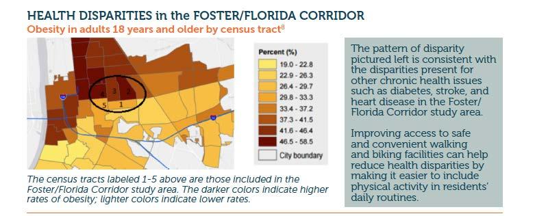
5 CT 10 CT CT CT 17 BG 2 CT 18 Complete Streets Pilot Program Study Area Census Tracts (CT) and Block Groups (BG) Identified
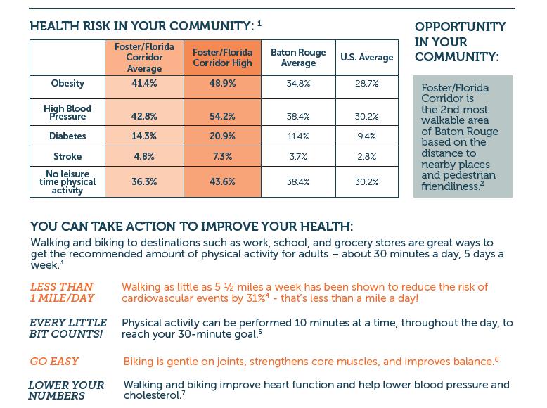
6 90% 80% 70% STAC Study Area 16,000 Residents 3.6% of parish population 4.1% of parish workers 60% 50% 40% 30% 20% 10% 0% Minority Non-Minority Seniors Workers 16+ Study Area EBR 6
7 Use Public Transit Bike to Work Walk to Work No Vehicle 0% 2% 4% 6% 8% 10% 12% 14% EBR Study Area 7

8 CT 10 CT CT CT 17 BG 2 CT 18 Complete Streets Pilot Program Study Area Census Tracts (CT) and Block Groups (BG) Identified
 Census block data for commuting and other job-related data Demographic and health data List of Geospatial Layers")
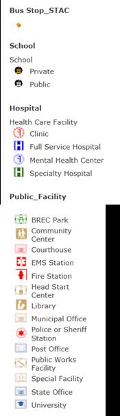
9 Locations of traffic signals and crosswalks Locations of CATS transit stops and ridership at each stop High demand public places, such as hospitals, schools, parks, community centers, libraries and other public facilities Locations of bicycle and pedestrian crashes ( ) Census block data for commuting and other job-related data Demographic and health data List of Geospatial Layers Compiled to Determine Target Areas Sources: EBR GIS, ELOS GIS, CATS, LADOTD, CityKey, American Community Survey
 of a Bus")
10 Access to Public Facilities Blue-shaded Area is within ¼-mile (5 minute walk) of a Bus Stop

11 Pedestrian Bike Crashes within 500 feet of Bus Stop
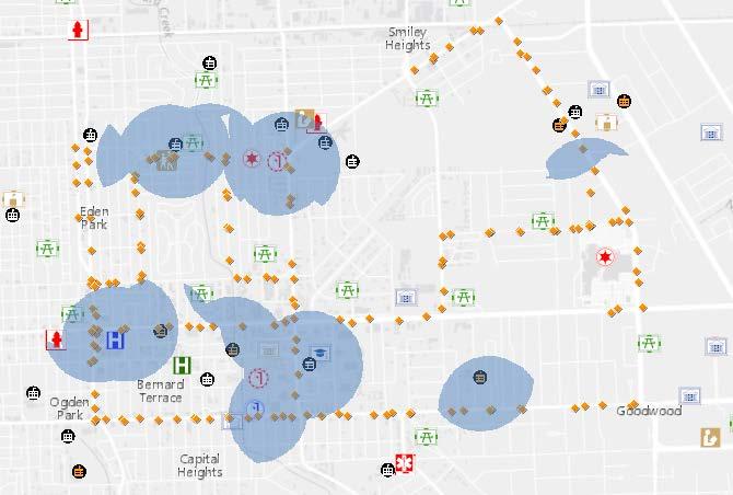
12 Identified Target Areas
13
14 joint initiative of COMMUNITY ENGAGEMENT RACHEL DIRESTO, CENTER FOR PLANNING EXCELLENCE
15 PUBLIC AGENCY PARTNERS BR Department of Transportation and Drainage BR Planning Commission Capital Area Transit System Louisiana Department of Transportation and Development Safety, Traffic Engineering, and District Engineers Capital Region Planning Commission (MPO) Mayor s Office Metro Council members (3 Districts) BREC
16
17
18
19
20
21
22
23
24 Final Video
25 OUTCOMES Top ranked project for Safe Routes to Public Places grant Local Road Safety Program Grant (Road Diet) Florida Boulevard Road Safety Assessment by DOTD GICD for Review of LADOTD Complete Streets Policy Florida Blvd Site Visit and Workshop BR IS/GIS Department to provide data & staff resources Tool for councilpersons to request coverage in their districts Two councilpersons already interested 25

26 MORE QUESTIONS? Troy J. Broussard Jeanne George Lynn Maloney-Mujica - lmaloney@elosenv.com Rachel DiResto rdiresto@cpex.org 26
12/9/2013. HOLLYWOOD/PINES CORRIDOR PROJECT AMPO 2013 Annual Conference October 24, Our Perspective. Broward.
 HOLLYWOOD/PINES CORRIDOR PROJECT AMPO 2013 Annual Conference October 24, 2013 Our Perspective Broward Fort Lauderdale 1 Broward Metropolitan Planning Organization Fort Lauderdale Fort Lauderdale Skyline
Por favor, levanten la mano si necesita traduccion en espanol Please raise your hand if you need Spanish translation
 FEDERAL BOULEVARD CORRIDOR WIDE STUDY PUBLIC MEETING #1 APRIL 27, 2016 Por favor, levanten la mano si necesita traduccion en espanol Please raise your hand if you need Spanish translation HDR DESIGN WORKSHOP
Complete Streets Master Plan for Downtown New Britain CRCOG Transportation Committee Meeting Monday, December 9, 2013
 CRCOG Transportation Committee Meeting Monday, December 9, 2013 Introduction Why the Project was Initiated About Downtown New Britain Master Plan Goals Master Plan Overview Master Plan Study Areas and
City of Hermosa Beach Administrative Policy #
 City of Hermosa Beach Administrative Policy # SUBJECT: Living Streets Policy Date: Approved by: City Council Authority: Public Works Department & Community Development Department Mayor, PURPOSE The City
Transit / Housing Oriented Redevelopment
 Broward County Urban Planning and Redevelopment Department Kick-Off Meeting October 24, 2007 Transit / Housing Oriented Redevelopment 1 Future Land Use 2 Broward County Charter Voters approved in 1974.
The Need to Develop a Transit Ready Community
 Evaluation & Appraisal Report (EAR) Major Issue # 6 The Need to Develop a Transit Ready Community July 3, 2007 EAR Major Issue # 6 Transit Ready Existing Comp Plan policies apply only to Indiantown Road:
Prince George s County Economic Development Corporation David Iannucci President & CEO
 Prince George s County Economic Development Corporation David Iannucci President & CEO WBC REGIONAL ECONOMIC DEVELOPMENT FORUM THE FUTURE OF PRINCE GEORGE S COUNTY Wednesday, March 6, 2019 Why Prince George
TRANSPORTATION MATTERS. Creating solutions for sustainable and accessible places
 TRANSPORTATION MATTERS Creating solutions for sustainable and accessible places WE PUT PEOPLE FIRST Nelson\Nygaard solves livability challenges through transportation planning. We integrate all modes of
TOWN COUNCIL / PLANNING COMMISSION
 Workshop #3 TOWN COUNCIL / PLANNING COMMISSION January 20, 2011 Consultant Team In Attendance Tonight BMS Design Group Nevada City and San Francisco Michael Smiley, AICP, ASLA Partner-in-Charge Nancy L.
Plano Tomorrow Vision and Policies
 Plano Tomorrow Vision and Policies PLANO TOMORROW PILLARS The Built Environment The Social Environment The Natural Environment The Economic Environment Land Use and Urban Design Transportation Housing
Kim DeLaney, Ph.D. Strategic Development Coordinator. Overview & Project Approach. Prepared by TCRPC (1/8/2014) 1
 1") Kim DeLaney, Ph.D. Strategic Development Coordinator Waterways Forum #2: Land Use & Upland Transportation Treasure Coast Regional Planning Council January 8, 2014 120+ Miles of Waterways St. Lucie County
Kim DeLaney, Ph.D. Strategic Development Coordinator Waterways Forum #2: Land Use & Upland Transportation Treasure Coast Regional Planning Council January 8, 2014 120+ Miles of Waterways St. Lucie County
REVIEW AND EVALUATION OF REGIONAL LAND USE
 REVIEW AND EVALUATION OF REGIONAL LAND USE AND TRANSPORTATION SCENARIOS #220831 Environmental Justice Task Force October 7, 2014 VISION 2050 Process Development of Guiding Vision for Land Use and Transportation
Walkable Urban Thoroughfares in Illinois Steps for Understanding and Overcoming Barriers
 Walkable Urban Thoroughfares in Illinois Steps for Understanding and Overcoming Barriers Chris McCahill, Project Assistant Heather Smith, Planning Director Congress for the New Urbanism www.cnu.org/streets
Tony Garcia, City-County Planning Commission & Beth Alden, Hillsborough MPO
 Tony Garcia, City-County Planning Commission & Beth Alden, Hillsborough MPO TOD Defined A compact neighborhood with housing, jobs and neighborhood services within easy walking distance of a transit station
Eastern Terminus TECHNICAL MEMORANDUM CENTRAL BROWARD EAST-WEST TRANSIT ANALYSIS BROWARD COUNTY, FLORIDA
 Eastern Terminus TECHNICAL MEMORANDUM CENTRAL BROWARD EAST-WEST TRANSIT ANALYSIS BROWARD COUNTY, FLORIDA FINANCIAL PROJECT ID NUMBER 411189-2-22-01 FLORIDA DEPARTMENT OF TRANSPORTATION DISTRICT 4 Prepared
Mount Pleasant Comprehensive Plan Public Open House Meeting. June 5, 2018
 Mount Pleasant Comprehensive Plan Public Open House Meeting June 5, 2018 The Planning Team Town Staff Liz Boyles - Principal Planner Brad Morrison - Transportation Director Christiane Farrell Assistant
CITY OF BOYNTON BEACH SE 1 ST STREET COMPLETE STREETS IMPROVEMENTS
 CITY OF BOYNTON BEACH SE 1 ST STREET COMPLETE STREETS IMPROVEMENTS N Project Location -Town Square -Villages at Ocean SE 1st St, between E Woolbright Rd and SE 2nd Ave Project Location -Boynton One -Publix
ROBBINSDALE LRT STATION CDI DEVELOPMENT GUIDELINES
 August 2018 OVERVIEW The City of Robbinsdale has a prime-opportunity site in the middle of the 13 mile stretch of the Bottineau LRT corridor / Blue Line extension. Robbinsdale offers a prominent, vital,
From Dismal to Great: How Underperforming Commercial Corridors are Crafting a Healthier, Better Connected Future
 From Dismal to Great: How Underperforming Commercial Corridors are Crafting a Healthier, Better Connected Future October 7, 2015 Urban Land Institute Fall Meeting San Francisco Participants: Moderator:
St. Louis Park Wooddale LRT Station Site development guidelines
 St. Louis Park Wooddale LRT Station Site development guidelines November 2013 OVERVIEW St. Louis Park s convenient location as a neighbor to Minneapolis means you re only minutes away from some of the
WALTER RAND TRANSPORTATION CENTER
 WALTER RAND TRANSPORTATION CENTER PLANNING AND DESIGN STUDY Public Meeting May 25, 2017 TONIGHT S AGENDA Introduction and Welcome Project Objectives The Study Area: WRTC and its Context Circulation Assessment
FDOT D4 Complete Streets
 FDOT D4 Complete Streets Context Sensitive Solutions Directs that complete street solutions will complement the context of the community. Collaborative approach to decision making, project development,
Eastside Transit Corridor Phase 2 Technical Study Update Community Outreach Meeting February 2017
 Eastside Transit Corridor Phase 2 Technical Study Update Community Outreach Meeting February 2017 Purpose of Tonight s Meeting Recap of Board motion (2014) and technical study process Provide update on
Future Proposed Development
 Future Proposed Development on and around Link light rail s Capitol Hill Station Meeting September 24, 2012 Tonight s Agenda 6:00 pm Open House 6:30 pm Introductions Richard Conlin, City of Seattle Councilmember/Sound
Project Goal. RRRC Living Towns Planning Workshp. Town of Halifax Revitalization Project. Dynamic Planning & Management Duo: July 12, 2006
 Project Goal Town of Halifax Revitalization Project RRRC Living Towns Planning Workshp July 12, 2006 Town of Halifax Halifax County *** Revitalization Project Goal*** To create Economic Opportunity and
New York Avenue Streetscape and Trail Project Public Meeting #1 Summary
 New York Avenue Streetscape and Trail Project Public Meeting #1 Summary I. King Jordan Student Academic Center (SAC) Gallaudet University, Washington, DC February 23, 2017 Table of Contents 1.0 Introduction...
Public Meeting & Workshop 1 April 26,2016
 Public Meeting & Workshop 1 April 26,2016 Northeast Ohio Areawide Coordinating Agency City of Cleveland ODOT Bike Cleveland Downtown Cleveland Alliance Ohio City Incorporated Warehouse District Agenda
Sustainable Infrastructure and South Mountain Village: Land Use and Transit Oriented Development
 Sustainable Infrastructure and South Mountain Village: Land Use and Transit Oriented Development COURSE PROJECT PRESENTATION 23 April 2018 Tari Alford Hanan Alhashmi Aric Burks Matt Gomez Matthew Waldman
Transportation Working Team Duane Diggs, Co-Chair (VOICE Buffalo) Kelly Dixon, Co-Chair (GBNRTC) Paul Ray, Facilitator (UB Regional Institute)
 Kelly Dixon, Co-Chair (GBNRTC) Paul Ray, Facilitator (UB Regional Institute)") towards a more sustainable Buffalo Niagara Transportation Working Team Duane Diggs, Co-Chair (VOICE Buffalo) Kelly Dixon, Co-Chair (GBNRTC) Paul Ray, Facilitator (UB Regional Institute) Agenda Welcome,
towards a more sustainable Buffalo Niagara Transportation Working Team Duane Diggs, Co-Chair (VOICE Buffalo) Kelly Dixon, Co-Chair (GBNRTC) Paul Ray, Facilitator (UB Regional Institute) Agenda Welcome,
West Ocala Vision & Community Plan City Council Work Session. Presented by West Ocala Community Plan Steering Committee
 West Ocala Vision & Community Plan City Council Work Session Presented by West Ocala Community Plan Steering Committee November 29,2011 Ocala 2035 Vision West Ocala Community Vision & Master Plan West
Robbinsdale LRT Station. CDI Development Guidelines. August Overview
 Robbinsdale LRT Station August 2018 Overview The City of Robbinsdale may have the coolest opportunity site along the 13 mile stretch of the Bottineau LRT corridor / Blue Line extension. Located a block
Q:%4~ Memorandum CITY OF DALLAS
 Memorandum DATE December 10, 2010 CITY OF DALLAS TO Members of the Transportation and Environment Committee: Linda Koop (Chair), Sheflie Kadane (Vice Chair), Pauline Medrano, Vonciel Jones Hill, Jerry
TRANSPORTATION ELEMENT GOALS, OBJECTIVES, AND POLICIES
 TRANSPORTATION ELEMENT GOALS, OBJECTIVES, AND POLICIES GOAL 2 The City shall provide a safe, convenient, effective, and energy efficient multimodal transportation system which is coordinated with the Future
The Trust for Public Land: Smart Growth for Dallas
 The Trust for Public Land: Smart Growth for Dallas Where could you walk in ten minutes? The Trust for Public Land land for people Trust for Public Land 4 Creating more parks for Texans Urban green assets
A BLUEPRINT FOR BROCKTON A CITY-WIDE COMPREHENSIVE PLAN
 A BLUEPRINT FOR BROCKTON A CITY-WIDE COMPREHENSIVE PLAN Public Meeting October 2016 1 Plan Summary and Discussion Public Meeting May 4 2017 City of Brockton Bill Carpenter, Mayor Department of Planning
TOD 101 CREATING LIVABLE COMMUNITIES WITH TRANSIT
 1 CREATING LIVABLE COMMUNITIES WITH TRANSIT What are transit Centered Communities? Benefits of Partnerships to Support and Implement What You Will Learn Portland s Pearl District Your Trainers Today Catherine
KCATA Transit Oriented Development Initiatives
 KCATA Transit Oriented Development Initiatives KCATA: Regional Transportation Authority Created by bi-state compact Approved by Congress 7 County service area Quasi-governmental with broad powers Power
BeltLine Corridor Environmental Study
 BeltLine Corridor Environmental Study Citywide Conversation on Transit and Trails April 2, 2009 Agenda & Introductions Introductions Environmental Study Process Overview of the BeltLine Project BeltLine
A larger version of this map is located on the last page of this PDF.
 MAP Committee Input McLoughlin Area Draft Vision Map A larger version of this map is located on the last page of this PDF. 1. The map above is intended to portray a vision for the McLoughlin area. It highlights
SPRINGFIELD, MA Technical Assistance Panel (TAP)
") SPRINGFIELD, MA Technical Assistance Panel (TAP) ULI the Urban Land Institute Mission To provide leadership in the responsible use of land and in creating and sustaining thriving communities worldwide.
SPRINGFIELD, MA Technical Assistance Panel (TAP) ULI the Urban Land Institute Mission To provide leadership in the responsible use of land and in creating and sustaining thriving communities worldwide.
A.1 New Policy Topic Areas
 A.1 New Policy Topic Areas TOPIC AREA #1 SUSTAINABILITY, OPEN SPACE & CONSERVATION Even though the term sustainability was not widely used when the General Plan was last updated, many sustainable policies
South Davis County COMMUNITY SPOTLIGHT
 South Davis County COMMUNITY SPOTLIGHT Davis/SLC Community Connector Bus Rapid Transit line connecting SLC & Davis County RTP Phase 1 Project Generate 3,100 average weekday riders Relieve congestion on
Chapter 4. Linking Land Use with Transportation. Chapter 4
 Chapter 4 Linking Land Use with Transportation Chapter 4 59 Chapter 4 Linking Land Use with Transportation Community Design and Transportation Program Introduction Since the 1950s, the predominant development
JANUARY 19, 2011 CENTRAL AVENUE-METRO BLUE LINE TRANSIT-ORIENTED DEVELOPMENT IMPLEMENTATION PROJECT COMMUNITY FORUM
 CENTRAL AVENUE-METRO BLUE LINE TRANSIT-ORIENTED DEVELOPMENT IMPLEMENTATION PROJECT COMMUNITY FORUM JANUARY 19, 2011 THE MARYLAND-NATIONAL CAPITAL PARK AND PLANNING COMMISSION PRINCE GEORGE S COUNTY PLANNING
The Atlanta BeltLine. Quarterly Briefing March @atlantabeltline. Reynoldstown Senior Affordable Housing
 The Atlanta BeltLine Quarterly Briefing March 30, 2017 @atlantabeltline @atlantabeltline @atlantabeltline Reynoldstown Senior Affordable Housing Framework for a multi-use and transit corridor in the heart
WAC #7 3/14/14. Coachella General Plan Update
 WAC #7 3/14/14 Coachella General Plan Update Agenda 2 Introductions Public Draft General Plan Overview and Discussion of Next Steps Implementation and Evaluation Health Element Process Evaluation (discussion)
TOWN OF NEW CASTLE - Master Plan Update
 Our Presentation Today (1) Recap the Master Planning Process To Date (2) Present the Outline of the Master Planning Work Plan (3) Present the Calendar for the Master Plan (4) Outline the scope of a Downtown
Peoria Avenue BRT Land Use Framework
 Planning Urban Design Landscape Architecture Historic Preservation Community Engagement Peoria Avenue BRT Land Use Framework Public Workshop Presentation Central Center Partners: Duncan Associates CLUE
METRO Gold Line BRT CBAC Meeting. August 23, 2018
 METRO Gold Line BRT CBAC Meeting August 23, 2018 1 Today s Topics Introductions Corridor Management Committee Update Public Engagement Update History of Alignment Project Scope Discussions Upcoming CBAC
Green Infrastructure The Indianapolis Greenways Connection
 Green Infrastructure The Indianapolis Greenways Connection Fewer things in the transportation industry today make better since than combining the needs for pedestrian and bike trails with the need to locate,
BUDGETING FOR OUTCOMES TRINITY RIVER CORRIDOR
 BUDGETING FOR OUTCOMES TRINITY RIVER CORRIDOR Trinity River Corridor Team Members: Kelly High, Streets Department Megan Lam, Office of Financial Services Mike Mikeska, Dallas Water Utilities Diana Ochoa,
TRANSIT-ORIENTED DEVELOPMENT PLAN PRESENTATION RED-PURPLE BYPASS PROJECT AREA
 TRANSIT-ORIENTED DEVELOPMENT PLAN PRESENTATION RED-PURPLE BYPASS PROJECT AREA Purpose Create a community-led vision for redevelopment in the neighborhood Test specific concepts for CTA-owned parcels Expedite
MORRISVILLE TRANSPORTATION PLAN TOWN COUNCIL PRESENTATION AUGUST 22, 2017
 TOWN COUNCIL PRESENTATION AUGUST 22, 2017 SCENARIO PLANNING CORRIDORS Town Hall Drive Baseline + 2 McCrimmon Parkway Baseline + 2 NC 54 Baseline + 2 7 subregion model runs determining carrying capacity
UNIVERSITY CITY AREA PLAN. Volume Two: Implementation Plan
 UNIVERSITY CITY AREA PLAN Volume Two: Implementation Plan Transforming the University City MSD into the vibrant, people-oriented place envisioned in the University City Plan will occur incrementally through
a vibrant office and retail development enters the gateway to rutherford county
 a vibrant office and retail development enters the gateway to rutherford county PF UP Introducing Fountains at Gateway in Rutherford County Fountains at Gateway is a new 31-acre Class A multi-tenant office
Nassau County Cultivating Opportunities for Sustainable Development Nassau County Infill Redevelopment Feasibility Study
 Nassau County Cultivating Opportunities for Sustainable Development Nassau County Infill Redevelopment Feasibility Study NY-CT Sustainable Communities Steering Committee Meeting March 14, 2014 Project
Planning and Operational Applications of TRANSIMS
 Planning and Operational Applications of TRANSIMS Brian Wolshon, Ph.D., P.E. Louisiana State University Gulf Coast Center for Evacuation and Transportation Resiliency 2011 DOTD Congestion Management Seminar
EXPO LINE COMMUNITY WORKSHOPS NOVEMBER 27 TH & DECEMBER 3 RD Los Angeles Department of City Planning
 EXPO LINE COMMUNITY WORKSHOPS NOVEMBER 27 TH & DECEMBER 3 RD 2012 Los Angeles Department of City Planning Agenda for Tonight Open House 6:00 to 6:15pm Presentation and Questions 6:15 to 6:50 Small Group
ELK GROVE GENERAL PLAN VISION
 2-1 CHAPTER 2: 2-2 CREATING OUR The Community Vision for Elk Grove, expressed through a Vision Statement and a series of Supporting Principles, is a declaration of the kind of community that Elk Grove
Transit-Oriented Development (TOD) along Metro Rail Corridor Open House. A Regional Economic Development Opportunity
 along Metro Rail Corridor Open House. A Regional Economic Development Opportunity") Transit-Oriented Development (TOD) along Metro Rail Corridor Open House A Regional Economic Development Opportunity August 29, 2018 1. Project Context Metro Rail Extension Four segments for analysis: 1
Transit-Oriented Development (TOD) along Metro Rail Corridor Open House A Regional Economic Development Opportunity August 29, 2018 1. Project Context Metro Rail Extension Four segments for analysis: 1
Oroville Area Urban Greening Plan. Joint Meeting of the Oroville Planning, Park, and Arts Commissions October 12, 2015
 Oroville Area Urban Greening Plan Joint Meeting of the Oroville Planning, Park, and Arts Commissions October 12, 2015 Project Team Lead Agency Butte County Department of Development Services Claudia Stuart,
Atlanta BeltLine Subarea 3 Master Plan Update
 Atlanta BeltLine Subarea 3 Master Plan Update April 14, 2018 Workshop Meeting 1 22 miles, connecting 45 neighborhoods 22 MILES of transit 46 MILES of streetscapes and complete streets 33 MILES of urban
SAN MARTIN BOULEVARD OVER RIVIERA BAY PROJECT DEVELOPMENT & ENVIRONMENT (PD&E) STUDY
 STUDY") KICK-OFF PRESENTATION SAN MARTIN BOULEVARD OVER RIVIERA BAY PROJECT DEVELOPMENT & ENVIRONMENT (PD&E) STUDY PROJECT IDENTIFICATION NUMBER (PID): #001036A May 13, 2015 1 2 PROJECT LOCATION PROJECT HISTORY
KICK-OFF PRESENTATION SAN MARTIN BOULEVARD OVER RIVIERA BAY PROJECT DEVELOPMENT & ENVIRONMENT (PD&E) STUDY PROJECT IDENTIFICATION NUMBER (PID): #001036A May 13, 2015 1 2 PROJECT LOCATION PROJECT HISTORY
Tropicana Site Redevelopment Committee of the Whole September 8, Image: City of St. Petersburg
 Tropicana Site Redevelopment Committee of the Whole September 8, 2016 Image: City of St. Petersburg City of St. Petersburg Planning & Economic Development Department Leading the Process HKS Urban Design
This page left intentionally blank.
 July 2012 This page left intentionally blank. Table of Contents Appendix A : Project Development Checklist Appendix B: At-Grade Rail Crossings Appendix C: Maintenance and Operations Examples Appendix D:
Phase I Redevelopment Plan. First Community Meeting
 Hoboken Terminal and Yard Phase I Redevelopment Plan First Community Meeting May 31, 2011 One Hudson Place Phase I Redevelopment Plan Redevelopment Plan First Community Meeting Agenda 1. Redevelopment
The Village of Shirlington
 The Village of Shirlington Suburban Smart Growth Without Rail Transit July 2018 Agenda History (1940 to present) Attributes and Outcomes Lessons Learned Setting the Stage Arlington County Arlington is
Windsor Locks Transit-Oriented Development Planning Grant Request. Project Background
 Windsor Locks Transit-Oriented Development Planning Grant Request Project Background Downtown Windsor Locks runs along Main Street in the vicinity of the intersection of Routes 159 and 140. The current
4 Park Planning and Design
 4 Park Planning and Design Park Constellations Elliot Gateway/Mills Loring North Loop Commons Twins Minneapolis Park & Recreation Board Downtown Service Area Master Plan 4-1 PROJECT APPROACH REFERENCE
SCTPO Project Summary September 2014
 A1A MULTIMODAL CORRIDOR PLANNING AND ENGINEERING ANALYSIS Florida Department of Transportation SCTPO Project Summary September 2014 PRESENTATION FOOTER Meeting Agenda What We Plan To Do Project Background
1.0 Introduction. Purpose and Basis for Updating the TMP. Introduction 1
 1.0 Introduction The Town of Castle Rock is situated between the metropolitan areas of Denver and Colorado Springs, amidst a unique terrain of rolling hills, mesas, ravines, and waterways. Like many Front
Route 1 Corridor Study
 Route 1 Corridor Study Westbrook, Connecticut A Vision for the Connecticut Shoreline Public Informational Meeting July 28, 2015 Lower Connecticut River Valley Council of Governments Fitzgerald & Halliday,
PRINCE GEORGE S PLAZA TRANSIT DISTRICT DEVELOPMENT PLAN AND TRANSIT DISTRICT OVERLAY ZONE UPDATE
 PRINCE GEORGE S PLAZA TRANSIT DISTRICT DEVELOPMENT PLAN AND TRANSIT DISTRICT OVERLAY ZONE UPDATE UNIVERSITY PARK TOWN LISTENING SESSION JUNE 12, 2014 Prince George s County Planning Department The Maryland-National
TRANSPORTATION ELEMENT
 TRANSPORTATION ELEMENT GOAL I: To create and maintain a safe, efficient and aesthetic transportation system that encourages multi-modal transportation and promotes the mobility strategies of the Ocala
County Transportation Plan Workshop
 Poughkeepsie Dutchess County Transportation Council County Transportation Plan Workshop Harlem Valley Area July 20, 2011 1 Moving Dutchess Harlem Valley Area 2 1. Introductions 2. PDCTC Overview (15 min.)
Mission and Vision Workshop February 5, 2015
 Mission and Vision Workshop February 5, 2015 Agenda Introduction What Is a Mission Statement? What is a Vision Statement? Examples from Other Communities Mission/Vision Evaluation Discussion 2 Process
DEPARTMENT OF PLANNING JEFFERSON PARISH, LOUISIANA
 DEPARTMENT OF PLANNING JEFFERSON PARISH, LOUISIANA DESIGN REVIEW REPORT DOCKET NO: : : : Paul D. Johnston AT LARGE: A: Christopher L. Roberts B: Cynthia Lee-Sheng ADVERTISING DATES: PAB PUBLIC HEARING:
Local Placemaking Opportunities
 What if We Built Elmira Around Places? Elmira Downtown Development Annual Meeting April 26, 2006 Planning & Design PPS Highlights 48 states, 24 countries 1200 communities 1 million visitors to our web
b r a n c h av e n u e tr a n s it co r r i d o r r e vita lization pl a n a m o d el fo r s u b u r ban retro fit
 b r a n c h av e n u e tr a n s it co r r i d o r r e vita lization pl a n a m o d el fo r s u b u r ban retro fit P R I N C E G EO RG E S CO U NT Y, M D ADO PTED 0 p R O J E C T C AT E G O R Y : U R B
Public Meeting #1. April 07, 2010
 Public Meeting #1 April 07, 2010 Collaboration A Project of the Greater Cleveland Regional Transit Authority in partnership with the City of Cleveland and the City of Lakewood 2 Tonight s Agenda 1. Introduction
NJ s Land Use and Transit Policies
 1 NJ s Land Use and Transit Policies NJ TRANSIT created in 1979 to reverse decline of public transportation State Development & Redevelopment Plan adopted (1986) encourages growth in areas where population,
Sustainably Repositioning Greyfield Sites. Greyfield Sites Anywhere
 Sustainably Repositioning Greyfield Sites Jim Constantine Looney Ricks Kiss Architects Todd Poole 4ward Planning Greyfield Sites Anywhere Pennsylvania Chapter American Planning Association Conference 2009
A Vision. for East Baton Rouge. Spring 2011 draft
 A Vision for East Baton Rouge Spring 2011 Chapter 2 The FUTUREBR Vision Letter from Mayor-President Kip Holden Spring, 2011 I am pleased to introduce the first of Our Vision for the Future of East Baton
Transit Implementation Strategy Westside Study Group Meeting
 Westside Study Group Meeting February 27, 2012 The Portland Streetcar Passing Through a Park Near Portland State University Westside Study Group Meeting February 27, 2012 1. TIA Update 2. TIS Process To-Date
PUBLIC SPACES MASTER PLAN UPDATE (POPS) Joint Facilities Advisory Commission (JFAC) November 28, 2018
 Joint Facilities Advisory Commission (JFAC) November 28, 2018") PUBLIC SPACES MASTER PLAN UPDATE (POPS) Joint Facilities Advisory Commission (JFAC) November 28, 2018 1 AGENDA POPS Planning Context Timeline Public Input Final POPS Draft Next Steps 2 PLANNING CONTEXT
PUBLIC SPACES MASTER PLAN UPDATE (POPS) Joint Facilities Advisory Commission (JFAC) November 28, 2018 1 AGENDA POPS Planning Context Timeline Public Input Final POPS Draft Next Steps 2 PLANNING CONTEXT
City of Gonzales Gonzales Passenger Rail Station Master Plan
 Gonzales Passenger Rail Station Master Plan Final August 1, 2018 This report takes into account the particular instructions and requirements of our client. It is not intended for and should not be relied
ORANGE LINE TRANSIT NEIGHBORHOOD PLANS VAN NUYS NEIGHBORHOOD COUNCIL, PLUM COMMITTEE DEPARTMENT OF CITY PLANNING, CITY OF LOS ANGELES
 Photo: Mission Meridian(Moule & Polyzoides) ORANGE LINE TRANSIT NEIGHBORHOOD PLANS VAN NUYS NEIGHBORHOOD COUNCIL, PLUM COMMITTEE DEPARTMENT OF CITY PLANNING, CITY OF LOS ANGELES JULY 18, 2018 Project partially
ULI St. Louis Technical Assistance Panel
 ULI St. Louis Technical Assistance Panel ULI St. Louis Technical Assistance Panel Sponsored by: Citizens for Modern Transit in partnership with METRO ULI St. Louis Mission Statement The mission of the
Public Forum. Kelley s Corner: The Corner that Connects Us. The Cecil Group. March 7, Acton 2020 Town of Acton.
 Public Forum Acton 2020 Town of Acton March 7, 2013 AGENDA Purpose of Forum Kelley s Corner Project Examples of the Planning Processes Next Steps Dialogue: Questions and Answers PURPOSE Acton 2020 April
SELMON GREENWAY FEASIBILITY STUDY. For: Hillsborough County Metropolitan Planning Organization By: Renaissance Planning
 SELMON GREENWAY FEASIBILITY STUDY For: Hillsborough County Metropolitan Planning Organization By: Renaissance Planning SELMON GREENWAY FEASIBILITY STUDY VISION Multimodal connection between Bayshore Blvd
Transforming Saint John s Urban Heart -
 Transforming Saint John s Urban Heart - How Innovative Community Engagement Inspires a Bold Municipal Plan for a More Sustainable and Compact Saint John 2012 NNECAPA Conference - Brunswick, ME October
TOPIC AREA #1 SUSTAINABILITY, OPEN SPACE & CONSERVATION
 TOPIC AREA #1 SUSTAINABILITY, OPEN SPACE & CONSERVATION Even though the term sustainability was not widely used when the General Plan was last updated, many sustainable policies were incorporated throughout
Big Issues in Transportation
 Collaboration Between Universities and Cities To Create Sustainable Communities The University of Oregon s Sustainable City Year Program Marc Schlossberg, PhD Nico Larco, AIA Co-Founders/Co-Directors,
Mississippi Skyway Preliminary Engineering Report
 EXECUTIVE SUMMARY Mississippi Skyway Preliminary Engineering Report CITY OF RAMSEY, MINNESOTA DECEMBER 2014 City of RAMSEY EXECUTIVE SUMMARY Project Need and Intent The Mississippi Skyway pedestrian bridge
Atlanta BeltLine Corridor Environmental Study. Scoping Meeting August 2008
 Atlanta BeltLine Corridor Environmental Study Scoping Meeting August 2008 What Will We Be Discussing Today? Study Overview - How Did We Get Here? - What Is the Study About? - Who Is Involved? - Where Is
Courthouse Square Planning & Urban Design Study
 Courthouse Square Planning & Urban Design Study Transit Advisory Committee October 14, 2014 Andrew D huyvetter, AICP, Associate Planner Center for Urban Design and Research Department of Community Planning,
GREENING THE BOULEVARD Master Plan Concepts for Venice Boulevard between Lincoln and Sawtelle
 GREENING THE BOULEVARD Katherine Spitz Associates Inc. 4212½ Glencoe Avenue Marina Del Rey, CA 90292 310 574 4460 Fax 574 4462 January 2008 Table of Contents Overview Proposed Design Improvements Illustration
Hopkins. Development Guidelines May Overview. Sponsored by: Blake Road Corridor Collaborative City of Hopkins
 Hopkins Blake Road LRT Station Area Development Guidelines May 2015 Sponsored by: Blake Road Corridor Collaborative City of Hopkins Overview Hopkins is a dynamic community of over 17,000 residents located
Guiding Principles for the SR 520 Replacement Project
 Guiding Principles for the SR 520 Replacement Project Presentation to the Board of Regents Theresa Doherty Assistant Vice President for Regional Affairs May 18, 2006 F-14 The University of Washington is
I. DESCRIPTION OF PROPOSED ACTION... 1 A. General Description... 1 B. Historical Resume and Project Status... 2 C. Cost Estimates...
 PROJECT COMMITMENTS SUMMARY... S-1 1. Type of Action... S-1 2. Description of Action... S-1 3. Summary of Purpose and Need... S-1 4. Alternatives Considered... S-2 5. NCDOT Alternatives Carried Forward...