A Hierarchy of Activity Centres
|
|
|
- Alisha Hunter
- 5 years ago
- Views:
Transcription

1 3 The Big Ideas The overall concept for the waterfront is based on establishing: a hierarchy of Activity Centres that serve as key destinations along the waterfront, a Mobility Network of trails and green corridors that provide connectivity across the waterfront and into adjacent neighbourhoods within the City, and a system of Landmarks, Kiosks and Beacons to provide amenities for waterfront visitors. In keeping with the Vision and Principles for the waterfront, detailed design shall emphasize quality, accessibility, creativity and sustainability and will seek to elevate the profile of the waterfront as a connected whole where the City comes together on the shores of Kempenfelt Bay. A Hierarchy of Activity Centres The purpose of establishing a hierarchy of Activity Centres is to recognize the varying role, function and activity levels throughout the waterfront and to provide a framework for better distributing events, festivals and recreational activities across the waterfront. Currently, events are clustered in the Central Waterfront - particularly at Centennial Beach - an area that has reached its capacity as a waterfront destination, even as the City s population continues to grow. A comprehensive network of Activity Centres across the waterfront is expected to form the basis for potentially redistributing some events, alleviating congestion, and ensuring that the waterfront as a whole remains an inviting place that is full of vitality and a resource that is shared among residents and tourists. To maximize the capacity of the entire waterfront as a destination, this Waterfront + Marina Strategic Plan establishes the parameters for redistributing events and recreational activities in revitalized Activity Centres across the waterfront. The scale of programming that each of these centres is intended to accommodate is expressed through the hierarchy, which includes three scales - Primary Activity Centres, Secondary Activity Centres and Tertiary Activity Centres. Each class is defined by its typical catchment area (Regional, City-wide, local), and the level and type of activity generated by the destination. The significance and profile of the Activity Centre, in terms of its role in shaping the image of Barrie, is also reflected in the hierarchy. Detailed descriptions of each Activity Centre are provided in Chapter 4. Primary Activity Centres Four Primary Activity Centres have been identified, including: Centennial Park, Allandale Station Park, Spirit Catcher Park/City of Barrie Marina, and Heritage Park. These parks are intended to serve as the City s primary places for large events and recreation along the waterfront. These four parks will draw the largest numbers of visitors, and the quality of design and provision of facilities in these parks will reflect their high profile. Centennial Park, Heritage Park, and Allandale Station Park already act as Primary Activity Centres drawing visitors from across Barrie and beyond; proposed upgrades to Spirit Catcher Park and the Barrie Marina will elevate these Activity Centres as primary gathering places as well. Combined, the four Primary Activity Centres, along with lower-order Activity Centres will help to disperse activities that are currently concentrated most densely at Centennial Park. Secondary Activity Centres Eight Secondary Activity Centres have been identified across the waterfront, including: Johnson s Beach St. Vincent Park Bayview Park Military Heritage Park Memorial Square Minet s Point Park The Gables Tyndale Park As the waterfront evolves, these destinations will have the potential to draw a significant number of visitors, primarily from local neighbourhoods, but in many cases, from across Barrie as well. Each of these destinations has been, or will be, uniquely programmed to accommodate specific types of community events and forms of active recreation. Facilities such as pavilions, sports fields, swimming areas, water sport launch points, and internal trail networks are common in these parks. Each of these places will play a key role in defining the image of the waterfront, and like the Primary Activity Centres, these destinations will require ongoing maintenance and renewal to ensure they deliver a high quality experience for visitors. Tertiary Activity Centres Nine opportunities to establish Tertiary Activity Centres have been identified along the shoreline of Kempenfelt Bay, including at: Nelson Square Kempenfelt Park Tiffin Boat Launch J.C. Morrison Shipwreck Tollendal Woods Park Pioneer Park Dock Road Park Wilkins Beach Loyalist Woods In general, these Tertiary Activity Centres will generate lower levels of activity than the Secondary Activity Centres. Although the Tiffin Boat Launch and the J.C. Morrison Shipwreck will draw visitors from across Barrie and even beyond, in general, these parks are not intended to serve as primary gathering places along the waterfront. Limited facilities, are common in the Tertiary Activity Centres, related to the more passive forms of recreation for smaller groups of visitors. 9
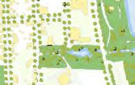
2 Discover Barrie Trail Barrie Heritage Trail Primary Activity Centre Secondary Activity Centre Tertiary Activity Centre Primary Activity Centres 6 Heritage Park 8 Spirit Catcher Park / City of Barrie Marina 9 Centennial Park 12 Allandale Station Park Secondary Activity Centres 1 Johnson s Beach Park + Barrie Yacht Club 3 St. Vincent Park 5 Bayview Park 7 Memorial Square 13 Military Heritage Park 14 Minet`s Point Park 15 The Gables Park 18 Tyndale Park Tertiary Activity Centres 2 Nelson Square 4 Kempenfelt Park 10 Tiffin Boat Launch 11 J.C. Morrison Shipwreck 16 Tollendal Woods Park 17 Pioneer Park 19 Dock Road Park 20 Wilkins Beach 21 Loyalist Woods Figure 5. A Hierarchy of Connected Activity Centres 10

3 Five Activity Centre Improvements In addition to developing a hierarchy of destinations, this Waterfront + Marina Strategic Plan includes plans for significant upgrades to five of the Activity Centres, including: Centennial Park, the City of Barrie Marina/Spirit Catcher Park, Military Heritage Park, Bayview Park, and Memorial Square. Significant opportunities to enhance the design and programming of these parks have been identified in consultation with City staff and members of the public, and are being brought forward with the overall Plan as big impact wins for the waterfront. More details on the plans for the five parks and the City s Marina can be found in Chapter 4: Components of the Plan, and Appendix A. Mobility Network Trails The Barrie Waterfront Trail and the Barrie Heritage Trails are proposed to provide a continuous interpretive trail network along the shoreline of Kempenfelt Bay. Combined, the two trails will extend from Hewitt s Creek/Wilkins Beach to beyond Johnshon s Beach, with the Barrie Heritage Trail covering the portion from Military Heritage Park to Nelson Square. A key trail improvement that is being introduced through this Plan and that will form part of this continuous waterfront route is the trail through Military Heritage Park, which is outlined in more detail on page 29. The proposed trail system builds on the existing network by providing connections between gaps and extending the network to the South Shore. Ultimately, the trails will connect all waterfront Activity Centres, from Wilkins Beach on the South Shore to Johnson s Beach on the Shore. The routes recommended in this Strategic Plan for linking the waterfront to various neighbourhoods will be included within the City s Multi Modal Active Transportation Master Plan. quality of the trail network will vary along the approximately 10 km of shoreline, depending on the character of the area and level of use. Notwithstanding this variation, wayfinding signage will be used as a unifying element to guide users along the different sections, and place-making features will be used to create recognizable points of interest along the route. The Barrie Heritage component of the trail system will build on the existing Historic Locations Plaques, which are placed along the waterfront to commemorate cultural heritage features such as the Allandale Train Station. Highly visual interpretive features and info corners will be installed along the trail network at key locations to enhance the sense of place for visitors. Posts and panels will highlight past events, natural heritage features, or other unique features that define Barrie s past, present and future. Innovative elements that are being considered as part of the interpretive program include electronic audio boards and the use of web-based apps. Environmental Connections Seven greenways are proposed for improvements on the waterfront, including Kidd s, Bunker s, Dyment s, Hotchkiss, Whiskey, Lover s and Hewitt s Creeks to connect the Central Waterfront and South Shore to the City. Where possible, the creation of these environmental connections will involve daylighting creeks that are currently channelized (Kidd s, Bunker s, Dyment s, and Hotchkiss). Daylighting involves opening up an underground culvert of a creek back above ground and restoring the corridor with naturalized plantings. Where the creeks already exist in natural corridors (Whiskey, Lover s, and Hewitt s) restoring the riparian environment will be a priority to enhance the creek s natural functions. Creating these new greenways will contribute to the City s efforts to improve stormwater management, sediment control, and will also improve biodiversity by creating new habitat. Where possible, the development of paths/trails along these naturalized corridors will improve connectivity for neighbourhoods within the City that are located adjacent to the waterfront. Stronger connectivity is particularly needed along the south end of the Central Waterfront where the rail corridor creates a barrier between neighbouring communities and the waterfront. In this area, additional connections would provide important linkages for pedestrians and cyclists, thereby improving the mobility options of local residents, while enhancing their access to the waterfront. In one example, a pedestrian/bicycle connection has been provided through the construction of a pedestrian tunnel across the rail corridor at Gowan Street. This tunnel connects the Allandale neighbourhood to the new Allandale Waterfront GO Station, and a trail connection into Allandale Station Park at the sundial time capsule. Along the South Shore, where the curvilinear local street network impedes access The trails are intended to be primarily multi-use, accommodating pedestrians and cyclists along a paved (or in some cases granular) path with a minimum width of 3 metres, or along boulevard trails and connecting between local residential streets. In some sections through wooded or environmentally sensitive areas, the path may be more pedestrian-scale with gravel, dirt or mulch surfaces, to minimize impacts on the local environment. In general, the 11
4 Environmental Connection On-Street Bicycle Route Multi-Use Trail Discover Barrie Trail Barrie Heritage Trail Beacon Location Transit Route Corridor Local Bus Stops Figure 6. A Connected Mobility Network 12


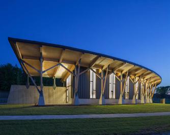
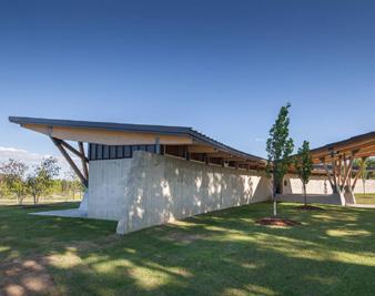
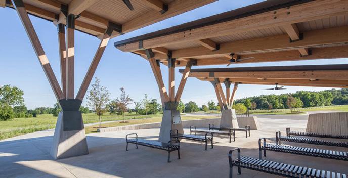
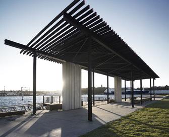
5 Place-Making & Safety Features between residents of South Barrie and the waterfront, the greenways will also improve connectivity. To complement the revitalized Activity Centres and Mobility Network, new place-making and safety features are proposed at key locations across the waterfront. First, highly visible beacons and info corners are proposed to animate the waterfront and to enhance its visibility for boaters, cyclists, pedestrians, and drivers. Second, to promote economic development, a system of kiosks are proposed as outlets for small-businesses along the waterfront that provide services and goods to visitors. Finally, to further promote comfort and safety, new pavilions, shelters and safety stations should be considered in locations where there is a need and demand. Along with new signage and street furniture, these proposed features will generate a recognizable and consistent image across the Shore, Central Waterfront and South Shore. This section provides general guidelines and demonstrative examples for the design of place-making and safety features for Barrie s Waterfront. The examples that are shown highlight potential options used in other jurisdictions across America. Final detailed design is expected to be undertaken by the City prior to implementing these concepts. General Guidelines Wood (left) and Cor-ten (right) Materials - Primary material choice should be wood and cor-ten steel. These materials should be used across the whole waterfront to create a consistent branding of place. Lighting - All light-emitting objects that are part of the waterfront should be designed to create the impression of intentionally-lit surfaces as opposed to general lighting. The lighting strategy should strive to achieve contrasts in light and dark. Low-key trail lights and grandly lit architectural facades are desirable examples, while stadium and parking lot lighting are not desirable examples. All lights should strive to minimize light pollution, lighting only what s necessary. Text - Use a sans-serif font for all signage and words. Beacons The beacons are meant to be part of a select series of highly visible landmarks from both within the city and across the bay. Lower parts of the beacon can be designed to accommodate a variety of programs not limited to the following: public art, a playground, a look-out platform, a tall-grass park. A conceptual design for the beacons is provided on page 14 as an example for detailed design. Location - The location of these new features should be coordinated with Activity Centres and the trail network. Preferred locations for the beacons are identified on Figure 7 on page 16, and include: St. Vincent Park Nelson Square Heritage Park (2) The Marina The Tiffin Boat Launch Minet s Point Dock Road Park Johnson s Beach Size - Beacons should be a minimum of 7.5m tall they must be tall enough to be clearly visible from across the bay and from within the city. Form - The beacons concept has a faceted look (i.e. complex surfaces broken down to triangles) with a clean, uncomplicated silhouette, like a thin glass shard. One surface remains flat all the way up, while the rest of the body takes on an irregular form. The straight side faces the water. Lighting - The beacon has a light that is installed as high as possible on the flat side that is visible from across the bay during the night. The light should be formally integrated to the beacon and not be made to look like a separate appendage. For extra visibility, beacons should have a strip of LEDs lights going vertically along the flat side facing the bay and must be dark sky compliant. In this way, the full length of the beacon will be visible during the night. Info Corners Spread along the waterfront, new Info Corners will provide information, including but not limited to the following: a map of the most visited attractions along the waterfront and the connecting trail systems, municipal services such as the nearest car parking and washrooms, and historical facts about the area. They are to be located close to entries into the waterfront trail system, outside public attractions, and on historically-significant locations. An optional interactive screen can be added which could be sponsored by an advertising agency. A conceptual design for the info corners is provided on page 14. Size - Height should be no taller than 3m, and no wider than 6m. Form - Main element should be thought of as a sculptural piece that consists of a metal plate, folded on one place to create a corner. Maximum angle of fold is 70 degrees. Each Info Corner can have a different wall silhouette. Info stops should provide generous seating behind it, always facing the water. Lighting - An integrated street light element should provide lighting to both sides of the wall. Kiosks A system of City-owned kiosks will be dispersed across the 10 km waterfront in appropriate locations. The kiosks will provide small-scale convenience or waterfront-related commercial opportunities, such as take-out food and beverages, rental businesses such as bikes, fishing gear and bait, watersports-related rentals and possible boating services. These kiosks will enhance the value and convenience of the Activity Centres, make the waterfront more attractive for visitors, and generate revenue for the City and private sector. They can be distributed either as stand along facilities, or in groups. Where appropriate, patios can be provided with the grouped kiosks by extending their concrete foundations. A conceptual design for the kiosks is provided on page 15. Location - In considering the location of kiosks, the City will restrict stand-alone kiosks in Primary and Secondary Activity Centres only, and will permit clusters of kiosks (up to 4 kiosks) in Primary Activity Centres only. In addition, kiosks shall only be located on public land in locations that are adjacent to the trails network or a public road. At a minimum, the kiosks will be served with electricity, and may have public water services where feasible. The kiosks will be considered a commercial opportunity, and and not a required element of any Activity Centre. When responding to a request for a kiosk from a business, the City will consider the location criteria outlined above. Administrative and management procedures for the commercial use of kiosks are provided in Chapter 5 of this Plan as part of the economic development strategy. Size - General size is encouraged to not be more than approximately 12 square metres in size. Form - It is recommended to use a small-size shipping container as a base building, for its ease of adaptability and cost-effectiveness, however, the City will need to determine the final kiosk concept design prior to proceeding with detailed design. Walls - Walls could be fixed or loose screen that acts as a wind block. Must have a flip-up shutter that opens/closes the stalls for security and that also provides shelter for customers at the stalls. Sign - One vertical strip of around 0.5-1m width to be consistent in design characteristic to local park signage for recognition. Foundation - Regardless of size, kiosks should be installed on a concrete base. The base can be made larger in order to accommodate patio space. Minimum patio space 13


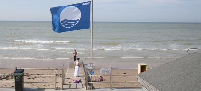
6 must be 3 times the floor area of the kiosk. Separation distances - Clusters of kiosks must allow enough distance between each other for doors, shutters and basic throughfare. It is encouraged to create micro-patios between food-vending kiosks, which can be made by increasing the foundation slab area by four times the total kiosk floor areas. Pavilions & Shelters 2-4 m 8-10 m min. 2 m Platform bench Large and flat seating surface Trail extension Hard surface to accommodate readers Pavilions are roofed structures with seating to accommodate group events, while shelters are smaller-scale structures that provide relief from the sun and rain for passerbys. Examples of attractive pavilions and shelters are provided on page 15. Pavilions Size - Waterfront pavilions should be no more than three storeys tall. Location - New pavilions should be considered in Activity Centres that are popular for picnicking, but are not currently served by a roofed shelter. Demand levels should be assessed as part of the new reservation system for group pavilions, as outlined in Chapter 5. Beacon HID-type bulbs, to be visible across the bay Light Provides overall lighting on both sides Wall of info Mounted on a corten base Form Structure - Pavilions should have structural wood trusses visible under the roof overhang. Roofs should be supported by expressive wood trusses that open up in a V-shape as they connect to the roof. Wall - All solid walls must have a pattern as part of a strategy to deter graffiti. Roof - There should be generous roof overhang on all sides to provide shelter around the pavilion. The depth of the roof overhang on the south side must minimize sun penetration during the summer and maximize it during the winter. The exact overhang dimension should be determined as part of detailed architectural design. In addition, roofs should be flat or inverted to emphasize the landscape horizon. Roofs should tilt up towards the lake. LED Light Strip Directional to reduce light pollution Conceptual Platform design info bench corners Large and flat seating surface Trail extension Hard surface to accommodate readers Lighting - Walls/roof should be underlit during night-time to animate the waterfront, and to ensure building/structure security. Shelters Form - The visibility of the structure should be minimized; the horizontal nature of the roof maximized. Location - The location of shelters should be assessed in coordination with the street furniture, wayfinding and interpretive program proposed for the entire waterfront at trail entrances/intersections and lookouts onto the Bay. Corten steel HID-type bulbs, to be visible across the bay Light Provides overall lighting on both sides Wall of info Mounted on a corten base Safety Stations Conceptual design for beacons Beacon precedents Info corner precedents To promote the responsible use of waterfront amenities, new safety stations should be considered along the waterfront. Safety stations provide important information about swimming conditions, hazards, rules, as well as the necessary equipment for responding to accidents, including a ring buoy and grab pole for retrieving people from the water when 14necessary. The location Barrie of safety Waterfront stations should + Marina be identified Strategic as part Plan of a feasibility - The Big study Ideas and be coordinated with any applications to certify Barrie s waterfront parks as Blue Flag Beacons Info Corners


7 Light shade Roof trellis structure supported by kiosks Blue Flag Beach (Image Credit: visitbritainnordicwordpress.com) m m (Standard container heights) Conceptual design for kiosks Kiosk precedents Architectural precedents Safety station precedents Kiosks Pavillions & Shelters Safety Stations 15
 Public Art Beacon Existing Community Centre Dunlop Street, Barrie s Mainstreet Proposed Mixed-Use Commercial Zone Areas of")

8 Major Road Major Railway Environmental Connection Discover Barrie Waterfront Trail Barrie Heritage Trail (Military Heritage Park to Nelson Square) Public Art Beacon Existing Community Centre Dunlop Street, Barrie s Mainstreet Proposed Mixed-Use Commercial Zone Areas of Significance i. Downtown Barrie ii. Allandale Intensification Node iii. Potential University Site Primary Activity Centre Secondary Activity Centre Tertiary Activity Centre Urban Growth Centre Boundary Study Area Boundary Transit Route Corridors Figure 7. Waterfront Concept Plan 16


9 Waterfront Trail Bicycle Route Multi-Use Trail Study Area Shore Downtown Barrie Central Waterfront South Shore Allandale Intensification Node Figure 8. Illustrative Waterfront Plan 17
Overview. Barrie Waterfront + Marina Strategic Plan - Executive Summary
 Overview Kempenfelt Bay stretches out like a long arm from the cool waters of Lake Simcoe, at the gateway to Southern Ontario s premier cottage country. In it s grasp lies the City of Barrie, wrapped around
Mark-up of the effect of the proposed Bronte Village Growth Area OPA No.18 on the text of section 24, Bronte Village, of the Livable Oakville Plan
 Mark-up of the effect of the proposed Bronte Village Growth Area OPA No.18 on the text of section 24, Bronte Village, of the Livable Oakville Plan Notes: This document is provided for information purposes
North Shore Trail. Council Meeting June 10, 2002
 North Shore Trail Council Meeting June 10, 2002 Process Guiding Principles Inventory and Analysis Preliminary Concepts (4) Final Concept Phasing Strategy Estimated Costs OVERVIEW Purpose: Prepare an overall
10.0 Open Space and Public Realm
 10.0 Open Space and Public Realm 10.0 Open Space and Public Realm The Public Open Space System is comprised of: outdoor spaces available for public use that are either publicly owned (e.g., parks and
Table 8-4: Road Classification Local Roads, second table, of Chapter 8 Create a Multi-Modal City, be amended by adding the following:
 1 Port Street East Official Plan Amendment APPENDIX 3 Amendments to Mississauga Official Plan Table 8-4: Road Classification Local Roads, second table, of Chapter 8 Create a Multi-Modal City, be amended
38 Queen s University Campus Master Plan Part 1
 38 Queen s University Campus Master Plan Part 1 46 The Campus at the City Scale Chapter 4 The Campus at the City Scale 39 Queen s is an urban University centrally located in Kingston. Decisions made by
Please read the entire document
 projects impacting the waterfront revitalization area. The waterfront revitalization area of the town will have to subareas to the west and east of the village. Page 6 of 6 Wayfinding master plan create
Welcome. Community Consultation Meeting November 28, Review and discuss the Bathurst Quay Neighbourhood Plan Framework
 Welcome Community Consultation Meeting November 28, 2016 Why Are We Here Today? Review and discuss the Bathurst Quay Neighbourhood Plan Framework Review and discuss an Action Plan for Implementation Next
Animating the Rideau Canal December 2013
 Executive Summary Animating the Rideau Canal December 2013 Why study the Rideau Canal? The Rideau Canal has been an important part of Ottawa throughout its history, and has shaped and been shaped by the
WELCOME and introduction
 1 WELCOME and introduction Mobility Hub Locations within Burlington STUDY OVERVIEW STUDY OBJECTIVES The City of Burlington is developing four Area Specific Plans, one for each of Burlington s Mobility
Highland Falls Waterfront Redevelopment Feasibility Study Village Board Meeting March 20, 2017
 Village Board Meeting March 20, 2017 Agenda I. Public Meeting #1 Visioning Summary II. Public Meeting #2 Comment Summary III. IV. IV. Case Study: Milton Train Station Schematic Design Concepts Schedule/Next
Corridor Vision. 1Pursue Minnehaha-Hiawatha Community Works Project. Mission of Hennepin County Community Works Program
 1Pursue Minnehaha-Hiawatha Community Works Project Minnehaha-Hiawatha Community Works is a project within the Hennepin Community Works (HCW) program. The mission of the HCW program is to enhance how the
Landscape and Streetscape Design 2.5
 Landscape and Streetscape Design 2.5 2.5.1 Goals 2.5.2 Planting 2.5.3 Sidewalks and Pavement 2.5.4 Furnishings 2.5.5 Walls 2.5.6 Lighting 2.5.7 Stormwater 2.5.8 Street Cross Sections 2.5 LANDSCAPE AND
Highest & Best Use Study Marina Park Lands
 Executive Summary of Report MARCH 2006 TABLE OF CONTENTS 1. Introduction...1 2. Study Process...2 3. Highest And Best Use Program...3 4. Concept Plan...8 5. Public Area Animation...9 6. Marina Park Implementation
A. Selma Park, Davis Bay and Wilson Creek
 A. Selma Park, Davis Bay and Wilson Creek This waterfront neighbourhood consists of three separate community areas, linked by Highway 101, but with different character, land use patterns and future potential.
Wayfinding. North Gateway: Integrate a vertical gateway marker on the west side of Ward Street at the south corner of Vernon Street.
 3.3.6.2 Wayfinding Existing Conditions Wayfinding signage is important to direct visitors and tourists to different locations in the downtown. A significant part of the wayfinding signage in the downtown
PORT WHITBY COMMUNITY
 PORT WHITBY COMMUNITY SECONDARY PLAN UPDATE COMMUNITY IMPROVEMENT PLAN URBAN DESIGN GUIDELINES September 2015 DRAFT PROPOSED AMENDMENT NUMBER # to the Whitby Official Plan PURPOSE: The intent of this Amendment
Parks Master Plan Implementation: Phase I Waterfront Use and Design REPORT #: September 7, 2016 File #
 0 'O DI Lan-171-14 1 - THE CORPORATION OF THE TOWN OF COBOURG..,. STAFF REPORT TO: FROM: Mayor and Members of Council Dean A. Hustwick, Director of Recreation and Culture DATE OF MEETING: Committee of
Appendix H: Easement cross sections
 Appendix H: Easement cross sections SHARED PATH 1.5m FOOTPATH NATURE STRIP 7.3m CARRIAGEWAY 2.7m NATURE STRIP EXISTING PIPELINE 150mm DIA 5.0m (approx.) LOCAL ACCESS ROAD EXISTING PIPELINE 500mm DIA 2.7m
Complete Neighbourhood Guidelines Review Tool
 Complete Neighbourhood Guidelines Review Tool Prepared By: City of Regina Planning Department October 2014 Page 1 of 14 Community Development Review Checklist for Secondary Plans and Concept Plans The
TALL BUILDING GUIDELINES
 TALL BUILDING GUIDELINES Urban Design Guidance for the Site Planning and Design of Tall Buildings in Milton May, 2018 A Place of Possibility Contents 1.0 INTRODUCTION 1 1.1 What is a Tall Building? 2
Town of Whitby Waterfront Parks and Open Space Master Plan Final Report, January 2016
 CMS 20-16 Attachment #1 Town of Whitby Waterfront Parks and Open Space Master Plan Final Report, January 2016 Table of Contents Waterfront Master Plan Study Overview i Introduction 1 Overall Waterfront
5.1 Site Plan Guidelines
 5. Community Core Guidelines Development of the Community Core will take place by plan of subdivision and site plan approval. It will occur in a phased manner that will reflect the timing of residential
WELLINGTON STREET WEST COMMUNITY DESIGN PLAN
 36 3.CDP POLICIES 37 Wellington Street West CDP Vision Statement 38 3.1 Introduction 3.1.1 Purpose The development of buildings and public spaces is influenced by a variety of factors over time. City of
03 HIGH PRIORITY SITES
 03 HIGH PRIORITY SITES HOWARD PARK Howard Park is one of South Bend s largest riverfront parks, hosting nearly acres. Howard Park has a very passive landscape with a recreation building, ice skating rink,
BURTON STATION STRATEGIC GROWTH AREA PLAN UPDATE PUBLIC MEETING 3/26/18
 BURTON STATION STRATEGIC GROWTH AREA PLAN UPDATE PUBLIC MEETING 3/26/18 1 WHERE WE ARE? 2 PRIMARY OBJECTIVES OF THE PLAN UPDATE 1. Update the land use designation for Burton Station Village to reflect
CHAPTER 7: Transportation, Mobility and Circulation
 AGLE AREA COMMUNITY Plan CHAPTER 7 CHAPTER 7: Transportation, Mobility and Circulation Transportation, Mobility and Circulation The purpose of the Transportation, Mobility and Circulation Chapter is to
Community Design Guidelines. Port Wallace DRAFT
 Community Design Guidelines Port Wallace DRAFT Energy 1 2 3 Nature Movement Connections Built Form DRAFT Layout Energy 1 Nature Community Design Guidelines GREAT COMMUNITIES PROTECT, CELEBRATE, AND CONSERVE
GUIDELINES EXHIBITION PLACE LOCATION: OBJECTIVES. Structure Plan URBAN DESIGN GUIDELINES
 Development in the Exhibition Place lands will be consistent with the following urban design guidelines. They provide a framework for new development of the lands and are to be read in conjunction with
Streets for People, Place-Making and Prosperity. #TOcompletestreets
 COMPLETE STREETS FOR TORONTO Streets for People, Place-Making and Prosperity COMPLETE STREETS: A NEW APPROACH A Complete Streets design approach considers the needs of all users people who walk, bicycle,
Cit of Kitchener Ur 6 an Design Manual PARTA. Desi n for _--::
 Cit of Kitchener Ur 6 an Design Manual Date PARTA Year ) Desi n for k Nodes Corridors _--:: Section Page 01 of 12 2 INTRODUCTION Purpose & Application Nodes and Corridors have been identified as key intensification
Silverdale Regional Center
 Silverdale Regional Center Vision for Silverdale Regional Center The Silverdale Regional Center Plan (Plan) will guide the evolution of the Silverdale Regional Center from a collection of strip malls and
East Bayshore Road Neighbourhood
 East Bayshore Road Neighbourhood Northridge Property Management Urban Design Brief 3195 East Bayshore Road City of Owen Sound January 2016 East Bayshore Road Neighbourhood Northridge Property Management
LAKEVIEW VILLAGE VISION & MASTERPLAN PRESENTATION TO CITY OF MISSISSAUGA. April 9, 2018
 LAKEVIEW VILLAGE VISION & MASTERPLAN PRESENTATION TO CITY OF MISSISSAUGA April 9, 2018 AGENDA Introduction Vision Plan Comparison The Big Moves Trail Connections Plan Overview Districts Conveyance Comparison
M i s s i o n B a y W a t e r f r o n t
 114 M i s s i o n B a y W a t e r f r o n t Character of the Area: The Mission Bay Waterfront extends from Pier 48 at China Basin Channel to 18th Street in the Central Basin. This area of the waterfront
The Planning Partnership Baird + Associates TCI Management Consultants Ltd. Plan B Natural Heritage Wills Consulting Engineers Poulos & Chung Limited
 Little Lake Master Plan The Planning Partnership Baird + Associates TCI Management Consultants Ltd. Plan B Natural Heritage Wills Consulting Engineers Poulos & Chung Limited May 26, 2009 Purpose of Study
[PLANNING RATIONALE] For Site Plan Control and Lifting of Holding Zone By-Law 101 Champagne Avenue. May 23, 2014
![[PLANNING RATIONALE] For Site Plan Control and Lifting of Holding Zone By-Law 101 Champagne Avenue. May 23, 2014](/thumbs/75/71599615.jpg "[PLANNING RATIONALE] For Site Plan Control and Lifting of Holding Zone By-Law 101 Champagne Avenue. May 23, 2014") [PLANNING RATIONALE] For Site Plan Control and Lifting of Holding Zone By-Law 101 Champagne Avenue May 23, 2014 Contents 1.0 Introduction... 2 2.0 Site Context... 2 2.1 Adjacent Uses... 2 Figure 1: Site
[PLANNING RATIONALE] For Site Plan Control and Lifting of Holding Zone By-Law 101 Champagne Avenue May 23, 2014 Contents 1.0 Introduction... 2 2.0 Site Context... 2 2.1 Adjacent Uses... 2 Figure 1: Site
New-Cast Mixed-use Development Proposal King Street West, Newcastle, Ontario
 URBAN DESIGN BRIEF New-Cast Mixed-use Development Proposal King Street West, Newcastle, Ontario TABLE OF CONTENTS: 1.0 Executive Summary 2.0 Creating Vibrant and Sustainable Urban Places: Excerpts from
appendix and street interface guidelines
 appendix five: building and street interface guidelines appendix 5 building and street interface guidelines BOULEVARDS Boulevards are generally characterized by higher levels of traffic movement at higher
4 Park Planning and Design
 4 Park Planning and Design Park Constellations Elliot Gateway/Mills Loring North Loop Commons Twins Minneapolis Park & Recreation Board Downtown Service Area Master Plan 4-1 PROJECT APPROACH REFERENCE
Town of Cobourg Heritage Master Plan. Statutory Public Meeting
 Town of Cobourg Heritage Master Plan Statutory Public Meeting April 25 th 2016 Presentation Overview 1. Introduction 2. Project background and schedule overview 3. Review of strategic direction content
Chairman and Members of the Planning and Development Committee. Thomas S. Mokrzycki, Commissioner of Planning and Building
 LA.09.TOR (Toronto) DATE: TO: FROM: SUBJECT: Chairman and Members of the Planning and Development Committee Thomas S. Mokrzycki, Commissioner of Planning and Building Central Waterfront Secondary Plan
ELMVALE ACRES SHOPPING CENTRE MASTER PLAN
 ELMVALE ACRES SHOPPING CENTRE MASTER PLAN Contents 1.0 INTRODUCTION... 2 2.0 LOCATION... 2 3.0 EXISTING CONTEXT... 2 4.0 VISION & GUIDING PRINCIPLES... 2 5.0 LAND USE AND BUILT FORM... 4 5.1 St. Laurent
PUBLIC RIGHT-OF-WAY IN THIS CHAPTER PUBLIC REALM
 PUBLIC RIGHT-OF-WAY This section provides design guidelines for improvements in the public right-of-way. The public right-of-way refers to streets, sidewalks, non-vehicular thoroughfares, parks and greenways
{Best Practices. Summary of Tools, Strategies and Best Practices from 11 Michigan Case Study Communities
 Case Studies Michigan Coastal Community Working Waterfronts { Summary of Tools, Strategies and from 11 Michigan Case Study Communities Table of Contents Zoning...2 Community and Stakeholder Collaboration
Whitemarsh Comprehensive Plan Update: Housing & Land Use. Public Workshop #3: September 20, 2018
 Whitemarsh Comprehensive Plan Update: Housing & Land Use Public Workshop #3: September 20, 2018 Agenda Welcome Process Recap What We ve Heard The Plan Framework Review of Recommended Actions Land Use Housing
John M. Fleming Managing Director, Planning and City Planner. Old East Village Dundas Street Corridor Secondary Plan Draft Terms of Reference
 Report to Planning and Environment Committee To: From: Subject: Chair and Members Planning & Environment Committee John M. Fleming Managing Director, Planning and City Planner Old East Village Dundas Street
URBAN DESIGN BRIEF URBAN DESIGN BRIEF 721 FRANKLIN BLVD, CAMBRIDGE August 2018
 URBAN DESIGN BRIEF URBAN DESIGN BRIEF 721 FRANKLIN BLVD, CAMBRIDGE August 2018 DESIGN BRIEF CONTENTS PART A 1.0 INTRODUCTION 2.0 DESCRIPTION & ANALYSIS OF SITE CONTEXT 3.0 DESIGN CONSTRAINTS AND OPPORTUNITIES
Urban Design Manual PLANNING AROUND RAPID TRANSIT STATIONS (PARTS) Introduction. Station Study Areas
 Introduction. Station Study Areas") 111111 PLANNING AROUND RAPID TRANSIT STATIONS (PARTS) Introduction The ION rapid transit system will link Waterloo, Kitchener and Cambridge through a central transit corridor (CTC). There are a number
111111 PLANNING AROUND RAPID TRANSIT STATIONS (PARTS) Introduction The ION rapid transit system will link Waterloo, Kitchener and Cambridge through a central transit corridor (CTC). There are a number
Corridor Identity. Section 9. Introduction. Corridor Guiding Principles
 Corridor Identity An attractive and healthy community is a critical element of a quality place, and the design of quality places is a balance between environmental, economic, and social considerations.
DOWNTOWN GEORGETOWN PLANNING STUDY
 DOWNTOWN GEORGETOWN PLANNING STUDY Community Workshop #3 Thursday, May 4, 08 The Planning Partnership OVERVIEW OF STUDY, PROCESS & MILESTONES We are here PURPOSE OF THE STUDY To develop a clear vision
The Master Plan Framework
 The Master Plan Framework The East Harbour Master Plan advances the development of 60 acres of former industrial lands east of the Don River. The Master Plan outlines a vision for a vibrant, transit-oriented
1. Parks & Recreation Neighborhood Parks Community Parks Special Use Sites 2. Open Space 3. Trails
 Appendix A: Park Classifications The intent of parks and recreation classifications is to aid in making acquisition and design decisions for park sites, facilities and the organization of recreation space
REDMOND CENTRAL CONNECTOR ART & DESIGN MASTER PLAN
 REDMOND CENTRAL CONNECTOR ART & DESIGN MASTER PLAN Redmond Central Connector Master Plan design principles principles make it redmond: past, present, future not just a place with art, a place that is art
Tel: (705) Fax: (705)
 Fax: (705)") 521 and 525 Essa Road City of Barrie Tel: (705) 812-3281 Fax: (705) 812-3438 Email: INFO@IPSCONSULTINGINC.com 1 5 0 D U N L O P S T R E E T E A S T, S U I T E 2 0 1, B A R R I E O N T A R I O L 4 M 1 B
521 and 525 Essa Road City of Barrie Tel: (705) 812-3281 Fax: (705) 812-3438 Email: INFO@IPSCONSULTINGINC.com 1 5 0 D U N L O P S T R E E T E A S T, S U I T E 2 0 1, B A R R I E O N T A R I O L 4 M 1 B
NEW REGIONAL OFFICIAL PLAN HIGH LEVEL PROCESS & FRAMEWORK
 NEW REGIONAL OFFICIAL PLAN HIGH LEVEL PROCESS & FRAMEWORK Why A New Official Plan Originally the role of Regionally Planning and content of Regional Official Plan (1970s) primarily focused on protecting
UNIVERSITY TOWN NEIGHBOURHOODS 5.2 ECO-CORRIDOR MELBOURNE CAMPUS MASTER PLAN 2014
 5.2 ECO-CORRIDOR 37 ECO-CORRIDOR EXISTING CONDITIONS & VISION NEIGHBOURHOOD VISION Investment in the Eco-corridor Neighbourhood will signify the University s commitment to supporting local ecology and
Uptown Rideau Street Secondary Plan [Amendment #166, January 12, 2016]
![Uptown Rideau Street Secondary Plan [Amendment #166, January 12, 2016]](/thumbs/76/73760497.jpg "Uptown Rideau Street Secondary Plan [Amendment #166, January 12, 2016]") [Amendment #166, January 12, 2016] The policies of this Secondary Plan are in effect, save and except for the property at 560 Rideau Street, for which there remains a site specific appeal to this Secondary
[Amendment #166, January 12, 2016] The policies of this Secondary Plan are in effect, save and except for the property at 560 Rideau Street, for which there remains a site specific appeal to this Secondary
North Oakville East Parks Facilities Distribution Plan. November, 2009
 North Oakville East November, 2009 POLICY CONTEXT 1) Purpose a) The purpose of this document is to be a guide for the location, configuration, design and development of the parks system for the North Oakville
The Vision. Photo provided by The Minervini Group. 46 Vision, Objectives & Strategies
 Vision, Objectives & Strategies The is the public framework and guide for future development of the Grand Traverse Commons. The establishes public polices for infrastructure, the preservation of natural
Appendix A COMMUNITY IMPROVEMENT PLAN DESIGN GUIDELINES
 Appendix A COMMUNITY IMPROVEMENT PLAN DESIGN GUIDELINES INTRODUCTION The continuous and desirable improvement of Arnprior requires a clear understanding of what is envisioned for the Town. These Design
Public Consultation Summary: Lakeview Place Making Workshop January 30, 2008.
 Page 1 of 11 Public Consultation Summary: Lakeview Place Making Workshop January 30, 2008. 1.0 Introduction: On January 30, 2008 the City of Mississauga, in conjunction with the consulting team of Brook
Corridor Transformation Strategy
 Corridor Transformation Strategy County Road 22 Special Planning Area Design Guidelines January 2012 D14-06017 Corridor Transformation Strategy County Road 22 Special Planning Area Corridor Design Guidelines
Throughout. square. (Crystal City Vision Plan 2050)
") 1: Terms related to the PSMP document 1 public space (see also public realm, civic space) An open space designated on the regulating plan, accessible to all, including Plazas, Mini Parks, and Neighborhoods
1: Terms related to the PSMP document 1 public space (see also public realm, civic space) An open space designated on the regulating plan, accessible to all, including Plazas, Mini Parks, and Neighborhoods
WEST HARBOUR VISION DRAFT 1.0
 CONTEXT WEST HARBOUR VISION DRAFT 1.0 Historic West Harbour has been the arrival point, the departure point, and a meeting place for generations of people. Many have made the West Harbour communities of
Chapter 1: Introduction
 Chapter 1: Introduction The Penn Avenue Community Works Corridor Vision and Implementation Framework presents an integrated communitybased vision and a coordinated, long-term implementation framework for
Market Place Bythell Place Queen Street Park Riverside Park. Public Spaces. Blenheim CBD Streetscape Final Report 36
 37 39 41 43 Market Place Bythell Place Queen Street Park Riverside Park Final Report 36 Market Place Market Place is a key space for Blenheim s street life, it is a meeting place, retail edge and pedestrian
CONTENTS 6.1 URBAN DESIGN
 6-2 Urban Design and Sustainable Development 6.0 URBAN DESIGN AND SUSTAINABLE DEVELOPMENT CONTENTS 6.1 URBAN DESIGN 6.1.1 General Policies 6.1.2 The Public Realm 6.1.3 Streets and Blocks 6.1.4 Streetscapes
PRELIMINARY DESIGN + DEVELOPMENT PLAN
 WELCOME! To The Public Open House May 30 th, 2017 HARBOUR WEST PARKS Vision Project Overview The City s vision for Port Credit Harbour West Parks is to develop a vibrant waterfront destination that integrates
lot flankage Y street 16m 6m landscape strip for large site 3m landscape strip for small medium site
 Commercial General Commercial Objectives Create developments compatible with adjacent land uses in scale, function and character Define a consistent and attractive street edge with quality landscaping,
Route 347. New York State Department of Transportation Region 10, Long Island. THE GREENING of ROUTE 347
 The GREENING of Route 347 The Greening of Route 347 The Greening of Route 347: History 3 The Greening of Route 347 4 The Greening of Route 347 5 The Greening of Route 347 Smith Haven Mall 6 The Greening
Mixed Use Centres Development Permit Guidelines
 1 Mixed Use Centres Development Permit Guidelines Area Commercial or Mixed Use development occurring in City Centre, Urban Centre, Neighbourhood Centre, or Institutional Complex land use designations is
Lakeview and Port Credit District Policies Review Public Engagement Process
 Lakeview and Port Credit District Policies Review Public Engagement Process Brook McIlroy Planning + Urban Design/PACE Architects MSAi Architects Poulos and Chung Transportation Engineers December 11,
Design Considerations
 Essential to the development of a successful Master Plan for the Park Complex is input from the community that the park will serve. The community outreach component of the planning process included numerous
Sidewalks Street Lights
 Boston Complete Streets Guidelines 013 Boston Transportation Department Sidewalks Introduction 17 Sidewalk Design Principles 18 Sidewalk Zones 0 Sidewalk Zones Widths Preferred and Minimum Widths for Sidewalk
URBAN DESIGN BRIEF. 2136&2148 Trafalgar Road. Town of Oakville
 URBAN DESIGN BRIEF 2136&2148 Trafalgar Road Town of Oakville Prepared By: METROPOLITAN CONSULTING INC For 2500674 Ontario Inc November 2016 TABLE OF CONTENTS Page No. 1.0 Introduction/Description of Subject
Highland Village Green Design Guidelines
 Highland Village Green Design Guidelines Publishing Information Title Highland Village Green Design Guidelins Author The City of Calgary Status DRAFT - Proposed document subject to changes Additional Copies
Arlington, Virginia is a worldclass
 EXECUTIVE S U M M A RY Arlington maintains a rich variety of stable neighborhoods, quality schools and enlightened land use policies, and received the Environmental Protection Agency s highest award for
Shared Principles and Emerging Plan Directions
 Shared Principles and Emerging Plan Directions Introduction Since the Fairfield Neighbourhood planning process launched in June 2016, we have heard from many residents, businesses, groups and other people
HUMBER BAY PARK PROJECT - BUILDING CONCEPT
 WELCOME 1 Humber Bay Park, with its system of trails, rugged shoreline, and dramatic views, is a unique and rare waterfront experience within the larger metropolitan Toronto area offering a place for quiet,
Grantsburg Community Design Team (CDT)
") Grantsburg Community Design Team (CDT) Summary Report Overview On April 10-13, 2014, a team of (19) volunteer planners, design professionals, and community development educators volunteered their time
Grantsburg Community Design Team (CDT) Summary Report Overview On April 10-13, 2014, a team of (19) volunteer planners, design professionals, and community development educators volunteered their time
South th E ast Communit ity Centre (SECC)
") South East Community Centre (SECC) 1 New Park Design & Community Centre Update Thursday, February 8, 2018 Public Open House Thank you for attending this Open House! The town and the Consulting Team will
South East Community Centre (SECC) 1 New Park Design & Community Centre Update Thursday, February 8, 2018 Public Open House Thank you for attending this Open House! The town and the Consulting Team will
Smart Growth Development Checklist
 2004 Smart Growth Development Checklist Smart Growth Development Checklist Corporation of the City of New Westminster Guide and manage growth in a manner which is consistent with the principles of sustainable
Provide and maintain sufficient public parks, recreation facilities, and open space to meet the recreational needs of County residents and visitors.
 (ROS) Goal Provide and maintain sufficient public parks, recreation facilities, and open space to meet the recreational needs of County residents and visitors. OBJECTIVE ROS.01 The County shall acquire,
Workshop 3. City of Burlington Waterfront Hotel Planning Study. September 14, The Planning Partnership
 Workshop 3 City of Burlington Waterfront Hotel Planning Study September 14, 2017 The Planning Partnership The Waterfront Hotel Planning Study 01 The Brant & Lakeshore Planning Study will establish a Strategic
PARKS. Chapter Introduction
 Chapter 4. PARKS 4.1. Introduction This Parks Element of the 2016 Comprehensive Plan Update provides direction and guidance, based on citizen input, in order to improve and maintain the City s existing
Illustration of Eastlake Farmer s Cooperative Grain Elevator. Chapter 5: implementation 5-1
 Illustration of Eastlake Farmer s Cooperative Grain Elevator Chapter 5: implementation 5-1 chapter 5: implementation Introduction The Eastlake Subarea Plan includes a wide range of recommendations intended
4- PA - LD - LIVELY DOWNTOWN. LD - Background
 4- PA - LD - LIVELY DOWNTOWN LD - Background The downtown has been the service centre for the community since the city s inception and the area continues to supply people with their personal services,
ANCHOR TO ANCHOR. Rescale the street to create an iconic boulevard.
 ANCHOR TO ANCHOR Rescale the street to create an iconic boulevard. UR NE ER UV GO NE LA OBJECTIVES 1. Maintain appropriate traffic flow and prioritize commercial curb access 2. Mark gateways at the street
Cold Lake Marina Master Plan
 Cold Lake Marina Master Plan Intro to Team Moffatt & Nichol is recognized throughout the world for our role in the revitalization and redevelopment of urban waterfronts, including the evolution of modern
THEMES, VISION, + PRINCIPLES
 CHAPTER 2: THEMES, VISION, + PRINCIPLES This page intentionally left blank. 20 VISION DRAFT AUGUST 2018 2 2 THEMES, VISION, + GUIDING PRINCIPLES The Key Themes, Vision, and Guiding Principles presented
Secondary Plan - Annexed Lands. Vision Workshop Summary March 14th 2011
 Secondary Plan - Annexed Lands Vision Workshop Summary March 14th 2011 i Table of Contents 1.0 Executive Summary 1 1.1 Priority Directions 1 1.2 A Vision for the Annexed Lands 2 2.0 Introduction 2 2.1
QUESTION 8: What are your Public Realm priorities for implementation? What would you like to see happen first? TELL US WHAT YOU THINK
 Public Realm Plan How will the Public Realm Plan be implemented? The Public Realm Plan document will set out a vision for the next 30 years. Over time, Plan elements and aspects can be implemented as opportunities
The Recreational Heart of Cannington - MacLeod & Claire Hardy Parks
 The Site Claire Hardy Park and MacLeod Park are both located within the community of Cannington on opposing shorelines of the Beaver River and are accessible to each other by a footbridge spanning the
Welcome! HORSESHOE BAY PARK. Welcome!
 Welcome! HORSESHOE BAY PARK Welcome! Where are we in the process? Today we would like your input on how Horseshoe Bay Park can be upgraded to serve the community s needs better. CONSULT STAKEHOLDERS TAKE
Emerson Park Master Plan Update. Public Meeting III August 27, 2014
 Emerson Park Master Plan Update Public Meeting III August 27, 2014 Meeting Agenda: Project Update Presentation of Master Plan Components Discussion and Feedback The Path Forward: Building on the Concept
CAL POLY MASTER PLAN UPDATE, March 2015
 Some Key Themes in the General Guiding Principles Academic Mission The plan must foremost advance the University s academic mission and student success. Foresight and Adaptability The plan should take
CREATE A VIBRANT MIXED-USE COMMUNITY
 CREATE A VIBRANT MIXED-USE COMMUNITY Land Use Public Realm Plan Built Form Heritage Tell us what you think! Place a sticky note here or leave us a comment form LAND USE The land use framework of this Secondary
Key Moves in the Plan
 Key Moves in the Plan 2 Add housing that fits the neighbourhood s character Make it easier to leave the car behind Oak Bay Avenue Village plan to be completed in future planning process Future active transportation
1 Introduction. Chapter. In this chapter:
 Chapter 1 Introduction In this chapter: 1.1 A Snapshot of the Region 1.2 Towards a Sustainable Region 1.3 The Provincial Context 1.4 Purpose and Organization The Regional Municipality of York Official