Annual Report. In 2009, the Miami River Commission. Miami River Commission
|
|
|
- Bernadette Boone
- 5 years ago
- Views:
Transcription


 turned its attention to making South Florida s mixed-use river into a")

1 Miami River Commission Annual Report 2009 Volunteers plant the new vegetable and fruit garden with rain barrels and composter along the river s publicly-accessible south bank near the Miami River Commission s offices at 1407 NW 7th St. Volunteers are eligible to harvest and eat the fresh, healthy and free produce when it matures. Volunteers painting mural along the Miami In 2009, the Miami River Commission (MRC) turned its attention to making South Florida s mixed-use river into a place where the community can live, work and play. The work ahead is considerable: Completing the remaining two-thirds of the river s greenways; dredging and cleaning the Wagner Creek and Seybold Canal tributary, the most polluted body of water in Florida; and finishing an environmentally continued next page
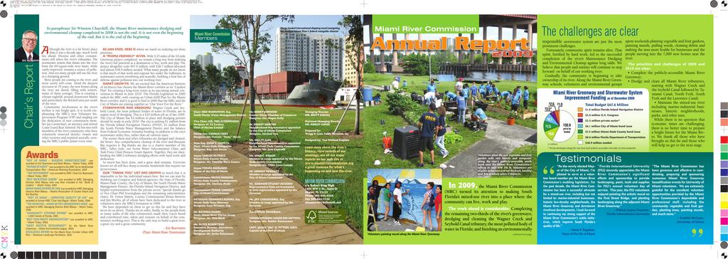
2 The challenges are clear responsible stormwater system are just the most prominent challenges. Fortunately, community spirit remains alive. That spirit, fortified by hard work, led to the successful completion of the river s Maintenance Dredging and Environmental Cleanup against long odds. We believe that people and entities will continue to step forward on behalf of our working river. Gradually, the community is beginning to take ownership of its river. Along the Miami, schools, volunteers and environmental groups $3.5* $ 6.1 $ 7.5 Miami and Stormwater System Improvement Funding as of December 2009 $ 2.6 $1.0 $8.0 in millions $38.9 yet to be funded As the newly elected Mayor of the City of Miami, I m pleased to serve as a volunteer board member per the Miami River Commission s enabling legislation. For the past decade, the Miami River Commission has been a successful advocate for a mixed-use river, including but not limited to: marine-industrial businesses, historic low-density neighborhoods, the Miami and downtown riverfront developments. I look forward to continuing my strong support of the Miami River Commission s noble initiatives, which improve South Florida s quality of life. Tomás P. Regalado, Mayor of the City of Miami Total Budget $67.6 Million $1.0 million Florida Inland Navigation District $2.6 million U.S. Congress $3.5 million private sector* $6.1 million City of Miami bond issue $7.5 million Miami-Dade County bond issue $8.0 million Florida Department of Transportation $38.9 million needed * Private developers along the river have built publicly-accessible riverwalks on their properties. Testimonials Florida International University (FIU) sincerely appreciates the Miami River Commission s significant efforts and sponsorship to provide landscaping, paint, tools and supplies for FIU s annual volunteer day of service. This year, the FIU volunteers enjoyed painting the artistic mural on the First Street Bridge, and planting landscaping along the adjacent Miami. Patricia Lopez-Guerrero, Florida International University spent weekends planting vegetable and fruit gardens, painting murals, pulling weeds, cleaning debris and making the area more livable for businesses and the people moving into the 7,000 new homes near the river. The priorities and challenges of 2009 and 2010 are clear: Greenway; starting with Wagner Creek and the Seybold Canal followed by Tamiami Canal, North Fork, South Fork and the Lawrence Canal; including marine-industrial businesses, historic neighborhoods, parks, and other uses. While there is no question that economic times are challenging, there is no better time to prepare a bright future for the Miami River. We thank all those who have brought us this far and those who The Miami River Commission has been generous and effective in coordinating, preparing and sponsoring numerous Miami beautification events for University of Miami volunteers. We are extremely grateful for the excellent volunteer opportunities provided by the Miami River Commission s dependable and professional staff, including the community vegetable and fruit garden, planting trees, painting murals, and much more. Franklin McCune, University of Miami

3 To paraphrase Sir Winston Churchill, the Miami River maintenance dredging and environmental cleanup completed in 2008 is not the end. It is not even the beginning of the end. But it is the end of the beginning. ERIC BUERMANN Chair s Report A lthough the river is a far better place than it was a decade ago, much work lies ahead. Dioxins and other contaminants still infest the river s tributaries. The stormwater system that drains into the river from the 69-square-mile river basin, while vastly improved, remains a source of pollution. And too many people still use the river as a dumping ground. More people are coming to the river, and more surely will come. Amid the deepest recession in 70 years, the new homes along the river are slowly filling with renters, many of them younger. This is creating a vibrant nightlife around downtown Miami and particularly the Brickell area just south of the river. Community involvement in the river s welfare is one bright spot. It is worth emphasizing the MRC s new Voluntary Improvement Program (VIP) and singling out the dedication of new commission member Jay Carmichael, an attorney and retired Coast Guard Rear Admiral. He has met with members of the river community who have voluntarily removed derelict vessels and other eyesores and repaired seawalls, earning the MRC s public praise every time. Awards BEST OF MIAMI BUILDING INFRASTRUCTURE was awarded to Eric Buermann and Brett Bibeau Miami Today, 2008 AWARD OF MERIT was awarded to the MRC for its Multimodal Transportation Plan American Planning Association, 2007 THE NEWSMAKER was awarded to MRC Chair Eric Buermann Miami Today, 2007 BEST BACKSTAGE LEADER was awarded to MRC Managing Director Brett Bibeau who was then included in the Book of Leaders Miami Today, 2007 MIAMI IMAGE AWARD OF 2006 was awarded to MRC Managing Director Brett Bibeau Realtor Association of Greater Miami and the Beaches BEST OF MIAMI IMPROVING QUALITY OF LIFE was awarded to former MRC Chair Irela Bagué Miami Today, 2006 THE ACHIEVER MIAMI RIVER S RENAISSANCE MAN was awarded to MRC Managing Director Brett Bibeau Miami Today, 2006 COMMUNITY STEWARD AWARD was awarded to MRC 1,000 Friends of Florida, 2005 BEST NON-PROFIT ORGANIZATION was awarded to MRC Miami Today, 2004 MOST POSITIVE DEVELOPMENT for the Miami River Greenway Urban Environment League, 2004 EXCELLENCE AWARD for the Miami River Corridor Urban Infill Plan American Landscape Architects, 2003 AS 2009 ENDS, HERE IS where we stand on realizing our three priorities: A PEOPLE-FRIENDLY RIVER. With 3.25 miles of the 10-mile Greenway project completed, we remain a long way from realizing the river s full potential as a destination to live, work and play. The project altogether costs $67.6 million, with $28.7 million allocated and almost $38.9 million needed. What many people do not know is that much of that work and expense lies under the walkways, in stormwater system retrofitting and seawalls, building a final line of defense against pollution into our working river. SMART GROWTH. We are excited that the American Institute of Architects has chosen the Miami River corridor as its Catalyst Plan for creating a long-term vision at its upcoming annual convention in Miami in June The Florida Legislature in 2000 tasked the MRC with creating an Urban Infill Plan for the Miami River corridor, and it is good to find in 2009 that the MRC and the City of Miami are joining together as One Voice For the River. STORMWATER AND DREDGING: Wagner Creek and Seybold Canal, the most polluted bodies of water in Florida, are in urgent need of dredging. This is a $20 million job as of late The City of Miami has $2 million in place and dredging permits should be ready in early The city is seeking $1 million from the Florida Inland Navigation District (FIND), $1 million from the South Florida Water Management District and the balance from Federal Economic Stimulus funding, in addition to the city s stormwater utility fees, rather than ad valorem taxes. The sooner these and other tributaries are dredged and cleaned, the better. Any comprehensive cleanup of the river and Biscayne Bay requires it. Big thanks are due to a charter member of the MRC, Sallye Jude, our Storm Water Subcommittee Chair, and Task Force Chair Horacio Stuart Aguirre. Together, they are shepherding the MRC s tributary dredging efforts with hard work and dedication. So much has been done, and a great deal remains. Everyone knows we all still face sharp economic headwinds that require our perseverance. OUR THANK YOU LIST HAS GROWN so much that it is impossible to list the individual names here. But we can start by thanking our Congress and federal agencies; the State of Florida; Miami-Dade County; the City of Miami; the South Florida Water Management District; the Florida Inland Navigation District; and helpful representatives from the private sector. Special thanks go to Vice Chair Phil Everingham and the remaining subcommittee chairs, Dr. Ernest Martin, County Commissioner Bruno Barreiro and Jim Murley, all of whom have been dedicated to the river as volunteers since the MRC s formation in We have depended on them to get us this far and they have never let us down. Thanks are in order, finally, to the people from so many walks of life who volunteered, made their voices heard and contributed time, talent and treasure on behalf of the community s working river. This is the only way to build a great river, a great city and a great community. Eric Buermann Chair, Miami River Commission

4 Subcommittee Reports Miami Dr. Ernest Martin, Chair GREENWAYS CAME TO THE FOREFRONT as never before in In September, the City of Miami submitted an application with the MRC s technical assistance for a $38.9 million transportation grant from federal economic stimulus funds to complete the 10-mile publicly-accessible pathway featuring trees, parks, benches, decorative lighting, historic markers, way-finding signage and art in public places. The City and MRC expect to hear the outcome of the application in February That outcome could determine if the greenways are substantially completed in two or 20 years. The TIGER grant (Transportation Investment Generating Economic Recovery) is part of the American Recovery and Reinvestment Act of 2009, with the objectives of preserving and creating jobs, promoting economic recovery and investing in transportation. Competition is stiff. Roughly 1,400 applicants from all 50 states have requested a total of $57 billion, and only $1.5 billion is available. Failing that, the MRC can work with New mural in Lummus Park the City of Miami in seeking $2 million in grants a year. Completion of the greenways construction will only be the beginning. Once completed, they will require maintenance, security and special events for residents and visitors. As of late 2009, 3.25 miles of the Greenways or roughly a third have either been completed or are under construction, some through the help of local government, some through private developers. The Miami has fully funded and nearly completed construction documents for.87 miles of new Greenway sections scheduled for construction in 2010, and an additional 1.01 miles slated for That will leave an estimated 4.87 miles of Greenway needing funding, design and construction. Here is an update of the Greenway work in 2009: PUBLIC SECTOR: North shore under the 12th Avenue Bridge, by the Florida Department of Transportation (FDOT) North and south shore under construction by the new NW Fifth Street Bridge (FDOT) In 2009, Miami-Dade County began design of the fullyfunded, publicly-accessible riverwalk at the following sites: North and south shore beneath MetroRail North shore beneath South Miami Avenue Bridge South shore beneath MetroMover South shore beneath SW Second Avenue Bridge North shore between NW Third and NW Fourth Streets The City of Miami has full funding and is designing the publicly-accessible riverwalk at the following sites: North River Drive from NW 7th to 12th Avenues will be in 2010 South River Drive from NW 1st Street to the NW 5th Street Bridge will be in 2010 South River Drive from the NW 5th Street Bridge to the NW 12th Avenue Bridge will be in 2011 PRIVATE SECTOR: Epic (old Dupont Plaza site) Phase I riverwalk completed Mint riverwalk under construction Terrazas Riverpark Village riverwalk under construction River Oaks Marina and Condominium riverwalk under construction The collapsed seawall adjacent to the ancient Miami Circle site was replaced in 2009, and funding was appropriated for the publicly-accessible riverwalk, with cost shares from the State of Florida, Florida Inland Navigation District, South Florida Water Management District, City of Miami and the Miami Downtown Development Authority. Construction documents have been completed and the riverwalk is scheduled for construction in 2010, providing public access to this site purchased by the taxpayers in 1998 for $26 million. The Miami Circle was designated a National Historic Landmark in The MRC thanks State Rep. Luis Garcia, City Commissioner Marc Sarnoff and Spencer Crowley, FIND, for their strong support in bringing the long-awaited and widely-supported Miami Circle improvements to fruition. In keeping with its commitment to Greenways and alternative means of transportation, the MRC has embraced the City of Miami s Bicycle Master Plan, which includes completing the Miami. The MRC continues to coordinate and cosponsor volunteer cleanup and beautification of the river. For a partial list of participants and to learn how you can participate, see the Get Involved! section elsewhere in this report.


 water quality goals were established for Wagner Creek in 2007. Yet the water quality, while vastly improved, remains in need of further help.")


5 STORM WATER Sallye Jude, Chair THE SUBCOMMITTEE S most urgent task remains the dredging and environmental cleanup of Wagner Creek and Seybold Canal, deemed the most polluted bodies of water in the State of Florida. Permits should be completed in 2010, as design was finished in The City of Miami has $2 million available and is seeking an additional $18 million from federal economic stimulus funds, FIND and the South Florida Water Management District. Work can only begin when full funding is secured. This project is a component of the new Miami River Tributary and Canal Maintenance Dredging and Environmental Cleanup Action Plan, under the leadership of Horacio Stuart Aguirre s task force. Retrofitting the storm water system that serves the 69-square-mile Miami River Basin remains a major priority. The City of Miami has already retrofitted and repaired several of the old storm water systems and installed new solid waste interceptor baskets to prevent debris from entering the Miami River and Wagner Creek. New Total Maximum Daily Load (TMDL) water quality goals were established for Wagner Creek in Yet the water quality, while vastly improved, remains in need of further help. Responsible agencies include the City of Miami, MiamiDade Department of Environmental Resources Management and the Water and Sewer Department, South Florida Water Management District and the Florida Department of Environmental Protection. These water-quality renovations are recommended in the MRC s Miami River Basin Water Quality Improvement Plan, available at along with quarterly agency implementation progress reports. M UPPER RIVER Shipping and Marine Industrial Zone: Center of the river s trade and industry. The Miami Intermodal Center will link rail, air, freight, transit, pedestrian and vehicular traffic. Residential / Mixed Us marine-ind Existing Riverwalk Proposed Riverwalk Existing On-Road Greenway Proposed On-Road Greenway MIAMI RIVER GREENWAY S TIMELINE 1897 Railroad magnate Henry Flagler opens six-story Royal Palm Hotel, including first greenway 1910 Lummus Park created on Miami River s 1998 Parks For People bond Miami Florida Legislature creates issue passed by voters, section Miami River Commission funds portions of the along north shore from as a watchdog, advocate Miami Biscayne Bay to and clearinghouse for NW 2 Avenue the river. MIami Circle site discovered 2000 Florida Legislature passes Miami River Improvement Act 200 In partnership Trust for Pub the MRC, City and Miami-Da unanimously Miami River G Action
.")


6 URBAN INFILL James Murley, Chair THE MIAMI RIVER COMMISSION is excited to work with the American Institute of Architects to create the Miami River Catalyst Plan, during their national convention in June The MRC is working with Miami-Dade County to prepare their Evaluation Appraisal Report (EAR). Upon its completion, the EAR will lead to amending the Miami-Dade County Neighborhood Comprehensive Plan. The working river is critical to the river s planning. The upper river zone, mostly in unincorporated Miami-Dade County west of NW 27th Avenue, is the source of most of the working river s trade with the Caribbean, and the freight passes through the 5.5-mile-long river corridor to Biscayne Bay. The MRC is implementing the awardwinning Miami River Corridor Multimodal Transportation Plan, which in part includes short-sea shipping, which would load seaport freight on a barge for offloading in the industrial district, thus removing cargo traffic from downtown streets. In addition, the plan recommends a centralized freight forwarding center connecting to the existing rail lines and Miami International Airport. Construction has been completed on 7,078 units, the last of them finished in As of December 2009, 9,688 residential units have preliminary approval, but none are under construction. The recession and tightened credit make construction unlikely in In the meantime, renters and some owners are starting to fill vacant units, and the residential population in the downtown corridor is growing quickly, particularly among younger people who work in or near Miami s center. ECONOMIC DEVELOPMENT & COMMERCE Bruno Barreiro, Chair THE GLOBAL ECONOMIC slowdown has diminished the pace of development, but does not lessen the river s importance as a shallow-draft port for 100 ports of call in the Caribbean. The river s vital role will only increase with the likely freeing of Cuba s economy in the coming years and decades. In 2009 Miami-Dade County commenced a public planning process for the area bounded by the Miami River on IDDLE RIVER e Zone: Includes historic neighborhoods, ustrial businesses, parks, etc. LOWER RIVER Downtown Zone: Urban, high-density residential, offices, commercial businesses. Riverwalks link historic landmarks and parks along river. 1 with the lic Land, of Miami de County approve reenway Plan City of Miami adopts A Vision for Miami s 21st Century Parks & Public Spaces recommending completion of the Miami of the Miami 2007 Miami River Corridor Multi- Modal Transportation Plan created by Metropolitan Planning Organization and MRC recommending completion of the Miami continues 2008 Map 2001 Richard Troutner. All rights reserved City Bicycle Master Plan adopted recommending completion of the Miami Greenway and additional sections funded and designed for construction in

7 the east, Tamiami Canal on the south, NW 36th Street on the north and 42nd Avenue on the west. The Miami River Commission serves on the steering committee, where the public and area business owners are encouraged to participate. The Miami River Corridor Multimodal Transportation Plan includes a major recommendation to alleviate downtown truck traffic by implementing short-sea shipping operations linking the Port of Miami with the Upper River. There, they would link with other modes of transportation: rail, road and air, thereby reducing downtown truck traffic. Near the river corridor s western terminus next to the Miami International Airport (MIA), the Miami Intermodal Center is moving toward completion in three stages, with a rental car facility scheduled for an opening in April 2010, the MIA Mover in September 2011 and the Miami Central Station in spring Dredging Eric Buermann, Chair The Maintenance Dredging and Environmental Cleanup of the Miami River, successfully completed in November 2008, took 36 years of vision, 10 years of hard work and $89 million. Just as it did a year ago, the MRC is still seeking non-guaranteed reimbursements from the federal government for $21 million of dredging funding advanced in by the Florida Legislature ($15 million), South Florida Water Management District ($3 million) and the Florida Inland Navigation District ($3 million). That money was predicated on dredging the river to 17 feet rather than its authorized depth of 15 feet. The dredging was limited to that depth when crews hit rock at 15 feet, precluding deeper dredging. The MRC hopes that the federal government will reimburse the money soon. Get Involved! The Miami River Commission invites groups and individuals from the community to get involved in improving our river. To learn more about what you can do, check out our website at for updates. You can also call us at , or us at miamiriver@ bellsouth.net. We re at 1407 NW 7th Street, Suite D. Throughout 2009, the Miami River Commission coordinated volunteers of all ages and walks of life to create parks and greenways along the river through a series of events. The MRC is thankful to our growing list of sponsors, partially listed below, who contributed volunteers, supplies and funding for the greening of the river. The 14th annual free Miami Riverday Festival is scheduled on April 10, 2010, at Lummus Park at 250 NW North River Drive, from 11 am-4 pm. The 13th annual Volunteers creating new riverfront park along Miami festival on April 4, 2009, featured river boat tours, live music, environmental education, marine expo, historic re-enactors, children s activities and much more. All MRC and subcommittee meetings are publicly noticed. Public participation is encouraged. The full MRC meets on the first Monday of every month at noon, usually at the meeting room to the right of the MRC headquarters. Miami-Dade County City of Miami City Year Miami Florida Drawbridge Florida Department of Transportation Community Image Advisory Board EDAW/AECOM Budget Rent-A-Car Disney TREEmendous Miami, Inc. Volunteers beautifying the Miami MRC thanks volunteer event sponsors: South Florida Water Management District Hands On Miami Vila and Son Landscaping Corp. University of Miami Butler Service Center University of Miami School of Law UM H.O.P.E. (Helping Others Through Pro Bono Efforts) Florida International University Babson College Florida Wood Recycling Bridges The Miami River Commission thanks the Florida Department of Transportation for its recent work on improving the roads and bridges along the Miami River. The current, five-year phase of bridge construction is winding down as traffic patterns return to normal. Replacement of the NW Fifth Street Bridge, once a hazard to navigation since it was first built in 1929, is nearing completion in spring 2010 at an estimated cost of $54 million. The NW 12th Avenue Bridge was completed on schedule in spring 2009, with an expansion from four to six lanes at a cost of $64 million. The Tamiami Bridge, over the Tamiami Canal just west of 27 th Avenue, still awaits full funding, although the Project Development and Engineering (PD&E) study was completed in Miami-Dade County is seeking an additional $23 million to start building the $41 million bridge, supplementing $18 million from an existing county bond. Once funding falls into place, the new bridge would open in five years. The existing, historic 1921 bridge would move more than six blocks to the east and reopen as a pedestrian-only bridge connecting the City of Miami s Fern Isle Park on the south shore with a newly-acquired park expansion area on the north shore of the river s South Fork tributary. the SW First Street Bridge is slated for replacement in 2017 and is commencing a PD&E study in 2010.
8
Annual Report. Miami River Commission IN 2014,
 3D RENDERING Miami River Commission Annual Report 2014 IN 2014, exciting new private sector developments were planned along the mixed-use Miami River District, including high-density residential, hotels,
Miami River Commission Meeting Minutes December 7, 2015
 Miami River Commission Meeting Minutes Mr. Horacio Stuart Aguirre, Chairman of the Miami River Commission (MRC), convened the public meeting at noon,, 1407 NW 7 ST. Miami River Commission (MRC) Policy
City of Miami MIAMI RIVER BASIN WATER QUALITY IMPROVEMENT REPORT FOR FIRST AND SECOND QUARTER 2010
 Action Items 1. Storm water* a. Retrofit drainage in remaining areas of Miami River starting with Pinehurst neighborhoods This project included drainage work that consist of French drains, solid piping,
City of Miami MIAMI RIVER BASIN WATER QUALITY IMPROVEMENT REPORT FOR FOURTH QUARTER 2010
 Action Items 1. Storm water* j. Citywide Inlet and Outfall Cleaning* The Public Works crews continue cleaning citywide inlets and outfalls. k. Inlet Retrofit for the Wagner Creek Basin* No inlet retrofits
Promoting Economic Development Through Upfront SEPA Review: Lessons from South Downtown Tacoma
 Promoting Economic Development Through Upfront SEPA Review: Lessons from South Downtown Tacoma 1 This session will focus on the City of Tacoma s South Downtown Subarea Plan and associated Non-Project SEPA
{Best Practices. Summary of Tools, Strategies and Best Practices from 11 Michigan Case Study Communities
 Case Studies Michigan Coastal Community Working Waterfronts { Summary of Tools, Strategies and from 11 Michigan Case Study Communities Table of Contents Zoning...2 Community and Stakeholder Collaboration
TREASURE COAST REGIONAL PLANNING COUNCIL M E M O R A N D U M. To: Council Members AGENDA ITEM 5H
 TREASURE COAST REGIONAL PLANNING COUNCIL M E M O R A N D U M To: Council Members AGENDA ITEM 5H From: Date: Subject: Staff October 17, 2008 Council Meeting Local Government Comprehensive Plan Review Draft
Downtown Dubuque...it s a great time.
 Downtown Dubuque...it s a great time. Your timing could not be better to invest in Downtown. With hundreds of millions in public and private investment occurring on the City s downtown waterfront, millions
Redevelopment of Downtown
 June 25, 2013 Redevelopment of Downtown Old US 41 Corridor Redevelopment Masterplan Downtown Color Palette Southern Shores and Beaches Sherwin Williams Downtown Vision Rendering Old Florida Design EcoDistricts
Keyport. Vision for Keyport
 Keyport Vision for Keyport Keyport is a rural, historic waterfront village bounded and limited in size by its natural borders of water and the Naval Undersea Warfare Center. The community consists primarily
Great Plans for a Great City
 CHAPTER 1 Great Plans for a Great City 1 Figure 1.1 South Michigan Avenue today Figure 1.2 South Michigan Avenue will be one of many higher intensity, mixed-use corridors that will extend out from the
Prepared for the Citizens of Forsyth County by the City-County Planning Board
 Prepared for the Citizens of Forsyth County by the City-County Planning Board Bryce A. Stuart Municipal Building 100 East First Street, Winston-Salem, NC 27101 336.727.8000 www.cityofws.org/planning www.legacy2030.com
Atlanta BeltLine, Inc. Pathways to Urban Sustainability
 Atlanta BeltLine, Inc. Pathways to Urban Sustainability September 30, 2010 WHAT IS THE ATLANTA BELTLINE? Transit 22-mile loop Parks 1300 + new acres Trails 33 miles Jobs & Economic Development 20 areas,
Gary & Regional Investment Project. October 27, Creating Tomorrow Today Comprehensive Regional Plan - NIRPC
 Creating Tomorrow Today 2040 Comprehensive Regional Plan Gary & Regional Investment Project October 27, 2010 Creating Tomorrow Today - 2040 Comprehensive Regional Plan - NIRPC What is NIRPC? - Northwestern
Urban Planning and Land Use
 Urban Planning and Land Use 701 North 7 th Street, Room 423 Phone: (913) 573-5750 Kansas City, Kansas 66101 Fax: (913) 573-5796 Email: planninginfo@wycokck.org www.wycokck.org/planning To: From: City Planning
Route 1 Corridor Study
 Route 1 Corridor Study Westbrook, Connecticut A Vision for the Connecticut Shoreline Public Informational Meeting July 28, 2015 Lower Connecticut River Valley Council of Governments Fitzgerald & Halliday,
Moving from Vision to Action
 Moving from Vision to Action Photo: John Carvalho What does it mean for a city to move? To see its people belong and connect? To prosper? To become green? Those are the pillars that are helping Mississauga
Transit / Housing Oriented Redevelopment
 Broward County Urban Planning and Redevelopment Department Kick-Off Meeting October 24, 2007 Transit / Housing Oriented Redevelopment 1 Future Land Use 2 Broward County Charter Voters approved in 1974.
EXHIBIT A. Tax Increment Reinvestment Zone No. 1 (Town Center) First Amended Project Plan 1
 First Amended Project Plan 1") EXHIBIT A Tax Increment Reinvestment Zone No. 1 (Town Center) First Amended Project Plan 1 1 As amended by Resolution No. 2008-02-001(TR1R) of the Tax Increment Reinvestment Zone No.1, and approved to
EXHIBIT A Tax Increment Reinvestment Zone No. 1 (Town Center) First Amended Project Plan 1 1 As amended by Resolution No. 2008-02-001(TR1R) of the Tax Increment Reinvestment Zone No.1, and approved to
CHAPTER 7: Transportation, Mobility and Circulation
 AGLE AREA COMMUNITY Plan CHAPTER 7 CHAPTER 7: Transportation, Mobility and Circulation Transportation, Mobility and Circulation The purpose of the Transportation, Mobility and Circulation Chapter is to
A BLUEPRINT FOR BROCKTON A CITY-WIDE COMPREHENSIVE PLAN
 A BLUEPRINT FOR BROCKTON A CITY-WIDE COMPREHENSIVE PLAN Public Meeting October 2016 1 Plan Summary and Discussion Public Meeting May 4 2017 City of Brockton Bill Carpenter, Mayor Department of Planning
Issues Requiring Future Study
 Issues Requiring Future Study Transportation planning is an ongoing process that tends to identify new issues as it finds solutions for others. Some issues are so complex that a solution to one problem
Kick-off Meeting. FM No: ETDM No: 14050
 Kick-off Meeting FM No: 433511-1-22-01 ETDM No: 14050 June 26, 2014 FM No. 433511 1 22 01 Project Location 2 Project Purpose and Need Improve traffic operations and safety conditions at the intersections
Transportation Committee
 Transportation Committee Business Item No. 2013-286SW Meeting date: October 14, 2013 For the Metropolitan Council meeting of October 16, 2013 Subject: Southwest Light Rail Transit (Green Line Extension):
V. Vision and Guiding Principles
 V. Vision and Guiding Principles The Master Plan for the Powers Ferry Corridor seeks a foundation in the desires of the community. At times, various elements of the community offered opposing viewpoints,
DOWNTOWN WATERFRONT MASTER PLAN
 DOWNTOWN WATERFRONT MASTER PLAN City of St. Petersburg, Florida How did the downtown waterfront come to be? Why is the DWMP being created? What is the DWMP? What will be included in the DWMP? What is the
Green Infrastructure The Indianapolis Greenways Connection
 Green Infrastructure The Indianapolis Greenways Connection Fewer things in the transportation industry today make better since than combining the needs for pedestrian and bike trails with the need to locate,
Planning Commission March 14, Presented by: City of Bellingham Port of Bellingham
 Planning Commission March 14, 2013 Presented by: City of Bellingham Port of Bellingham 1 Agenda Waterfront District Background Waterfront District Proposal Overview Sub-area Plan Development Regulations
City of Hermosa Beach Administrative Policy #
 City of Hermosa Beach Administrative Policy # SUBJECT: Living Streets Policy Date: Approved by: City Council Authority: Public Works Department & Community Development Department Mayor, PURPOSE The City
Meeting Agenda. 1. Introductions (5 min)
") Meeting Agenda Monaca, PA Ohio River Brownfields Redevelopment Planning Federal/State/Regional Partners Meeting June 5, 2012; 3-4pm EDT Conference call-in #: 1-866-299-3188 Conference code: 202 566 0633#
Meeting Agenda Monaca, PA Ohio River Brownfields Redevelopment Planning Federal/State/Regional Partners Meeting June 5, 2012; 3-4pm EDT Conference call-in #: 1-866-299-3188 Conference code: 202 566 0633#
City of Meriden Harbor Brook Flood Control Project Overview
 City of Meriden Harbor Brook Flood Control Project Overview Updated August 2013 OVERVIEW The center of Meriden, including the HUB site is the low point of the town which is ringed by basalt ridges. Running
Transportation Working Team Duane Diggs, Co-Chair (VOICE Buffalo) Kelly Dixon, Co-Chair (GBNRTC) Paul Ray, Facilitator (UB Regional Institute)
 Kelly Dixon, Co-Chair (GBNRTC) Paul Ray, Facilitator (UB Regional Institute)") towards a more sustainable Buffalo Niagara Transportation Working Team Duane Diggs, Co-Chair (VOICE Buffalo) Kelly Dixon, Co-Chair (GBNRTC) Paul Ray, Facilitator (UB Regional Institute) Agenda Welcome,
towards a more sustainable Buffalo Niagara Transportation Working Team Duane Diggs, Co-Chair (VOICE Buffalo) Kelly Dixon, Co-Chair (GBNRTC) Paul Ray, Facilitator (UB Regional Institute) Agenda Welcome,
CHAPTER 7: VISION AND ACTION STATEMENTS. Noble 2025 Vision Statement
 CHAPTER 7: VISION AND ACTION STATEMENTS This chapter presents the vision, policy and action statements that transform the comprehensive planning study, an analysis of Noble s past, future trends and community
The Auburn Plan Designing the Future of Auburn February 28, 2005
 The Auburn Plan Designing the Future of Auburn February 28, 2005 Block-by-Block Bicycle Tour Aerial survey Focus Group Meetings September 7 and 8 Design Workshops October 11, 14, and 21 Revitalization
Mississippi Skyway Preliminary Engineering Report
 EXECUTIVE SUMMARY Mississippi Skyway Preliminary Engineering Report CITY OF RAMSEY, MINNESOTA DECEMBER 2014 City of RAMSEY EXECUTIVE SUMMARY Project Need and Intent The Mississippi Skyway pedestrian bridge
2035 General Plan Update and Belmont Village Specific Plan. Joint Study Session with the City Council and Planning Commission April 12, 2016
 2035 General Plan Update and Belmont Village Specific Plan Joint Study with the City Council and Planning Commission April 12, 2016 Agenda 1. Welcome and Introductions 2. General Plan Update Status of
Beachside Redevelopment Committee
 Beachside Redevelopment Committee DRAFT FINAL RECOMMENDATIONS MARCH 22, 2018 This is a new slide 2 This is a new slide Table of Contents I. Introduction and Overview II. III. Community Improvements and
Corridor Vision. 1Pursue Minnehaha-Hiawatha Community Works Project. Mission of Hennepin County Community Works Program
 1Pursue Minnehaha-Hiawatha Community Works Project Minnehaha-Hiawatha Community Works is a project within the Hennepin Community Works (HCW) program. The mission of the HCW program is to enhance how the
DRAFT Subject to modifications
 TREASURE COAST REGIONAL PLANNING COUNCIL DRAFT M E M O R A N D U M To: Council Members AGENDA ITEM 7C From: Date: Subject: Staff September 17, 2010 Council Meeting Commuter Rail Update Resolution of Support
Monday, October 5, THE LIGHTHOUSE, PIER 61 at CHELSEA PIERS, HUDSON RIVER PARK, NEW YORK CITY SPONSORSHIP DECK
 Monday, October 5, 2015 THE LIGHTHOUSE, PIER 61 at CHELSEA PIERS, HUDSON RIVER PARK, NEW YORK CITY SPONSORSHIP DECK ABOUT US Our Mission The Waterfront Alliance works to protect, transform, and revitalize
HILLSBOROUGH COUNTY Greenways and Trails Plan Update. Executive Summary. Date
 HILLSBOROUGH COUNTY Greenways and Trails Plan Update Executive Summary Date PURPOSE AND PROJECT OVERVIEW The Hillsborough County Greenways Master Plan (1995) and the City of Tampa s Greenways and Trails
Parks Master Plan Implementation: Phase I Waterfront Use and Design REPORT #: September 7, 2016 File #
 0 'O DI Lan-171-14 1 - THE CORPORATION OF THE TOWN OF COBOURG..,. STAFF REPORT TO: FROM: Mayor and Members of Council Dean A. Hustwick, Director of Recreation and Culture DATE OF MEETING: Committee of
8implementation. strategies
 PROGRAM STRATEGIES 8implementation strategies T he implementation actions of this chapter are designed to support and carry out the land use, economic development, transportation, urban design, and program
A Connected Region for Our Future. Tampa Bay Regional Planning Council
 A Connected Region for Our Future Tampa Bay Regional Planning Council TBARTA Vision A world class transportation network for the Tampa Bay region that will connect people and places, move goods and services,
The Rocky Mountain Arsenal and the Northeast Greenway Corridor Project:
 The Rocky Mountain Arsenal and the Northeast Greenway Corridor Project: Contamination to Collaboration Presented by Howard Kenison Overview of Presentation Rocky Mountain Arsenal Contamination Litigation,
Description. Summary. MCPB Item No. Date: 01/17/13. Bethesda Crescent, Limited Site Plan Amendment, A, A
 THE MARYLAND-NATIONAL CAPITAL PARK AND PLANNING COMMISSION MCPB Item No. Date: 01/17/13 Bethesda Crescent, Limited Site Plan Amendment, 81984005A, 81984003A Parag Agrawal, Senior Planner, parag.agrawal@montgomeryplanning.org,
SR 836 Southwest Extension
 SR 836 Southwest Extension Miami-Dade County, Florida August 8, 2018 MDX WORK PROGRAM NO.: 83618 Project Need Population growth and traffic in southwest Miami-Dade has significantly increased without the
11.0 TRANSPORTATION ELEMENT
 11.0 TRANSPORTATION ELEMENT Transit, Circulation and Parking Sub-Element: For all campuses, FIU's goal is to increase multimodal access. In combination with other measures - such as the development of
TRANSPORTATION ELEMENT GOALS, OBJECTIVES, AND POLICIES
 TRANSPORTATION ELEMENT GOALS, OBJECTIVES, AND POLICIES GOAL 2 The City shall provide a safe, convenient, effective, and energy efficient multimodal transportation system which is coordinated with the Future
Windsor Locks Transit-Oriented Development Planning Grant Request. Project Background
 Windsor Locks Transit-Oriented Development Planning Grant Request Project Background Downtown Windsor Locks runs along Main Street in the vicinity of the intersection of Routes 159 and 140. The current
G. RECREATION AND OPEN SPACE ELEMENT. The following summarizes the Recreation and Open Space Element:
 G. RECREATION AND OPEN SPACE ELEMENT The purpose of the Element is to provide the framework and direction for a comprehensive system of public and private sites for recreation, including, but not limited
40 Years of Smart Growth Arlington County s Experience with Transit Oriented Development in the Rosslyn-Ballston Metro Corridor
 40 Years of Smart Growth Arlington County s Experience with Transit Oriented Development in the Rosslyn-Ballston Metro Corridor A presentation by the Arlington County Department of Community Planning,
TOWN COUNCIL / PLANNING COMMISSION
 Workshop #3 TOWN COUNCIL / PLANNING COMMISSION January 20, 2011 Consultant Team In Attendance Tonight BMS Design Group Nevada City and San Francisco Michael Smiley, AICP, ASLA Partner-in-Charge Nancy L.
City of Tulsa BEAUTIFICATION TASK FORCE
 City of Tulsa BEAUTIFICATION TASK FORCE Submitted: November 29, 2012 at a meeting of the City Council with Mayor Dewey Bartlett Jr. Rationale Beautify Tulsa Statement: The Mayor and the Council share a
Chapter 11. Implementation Plan
 Chapter 11 Implementation Plan 127 D O W N T O W N T AV A R E S R E D E V E L O P ME N T MA S T E R P L A N IMPLEMENTATION PLAN This section shows how the Master Plan translates to a phased series of
Planning Commission Report
 Planning Commission Report To: From: Subject: Planning Commission Meeting: January 6, 2016 Agenda Item: 8-B Planning Commission David Martin, Planning & Community Development Director Introduction to the
greenprint midtown SUSTAINABILITY ACTION PLAN 2012
 greenprint midtown SUSTAINABILITY ACTION PLAN 2012 MIDTOWN ALLIANCE SOUTHFACE ENERGY INSTITUTE RENAISSANCE PLANNING GROUP SUSTAINABLE ATLANTA PERKINS+WILL 2 GREENPRINT MIDTOWN 1. Introduction Sustainability
CITY OF CHARLOTTESVILLE, VIRGINIA CITY COUNCIL AGENDA
 CITY OF CHARLOTTESVILLE, VIRGINIA CITY COUNCIL AGENDA Agenda Date: December 16, 2013 Action Required: Adoption of Resolution Presenter: Staff Contacts: Title: James E. Tolbert, AICP, Director of NDS James
Sacramento Area Council of Governments (SACOG)
") Sacramento Area Council of Governments (SACOG) The Blueprint Vision The SACOG Board of Directors adopted the Preferred Blueprint Scenario in December 2004, a bold vision for growth that promotes compact,
Sacramento Area Council of Governments (SACOG) The Blueprint Vision The SACOG Board of Directors adopted the Preferred Blueprint Scenario in December 2004, a bold vision for growth that promotes compact,
Introduction. Chapter 1. Purpose of the Comprehensive Plan Plan Organization Planning Process & Community Input 1-1
 Chapter 1 Introduction Lakewood 2025: Moving Forward Together Purpose of the Comprehensive Plan Plan Organization Planning Process & Community Input 1-1 Purpose of the Comprehensive Plan The Comprehensive
Plano Tomorrow Vision and Policies
 Plano Tomorrow Vision and Policies PLANO TOMORROW PILLARS The Built Environment The Social Environment The Natural Environment The Economic Environment Land Use and Urban Design Transportation Housing
The Village of Shirlington
 The Village of Shirlington Suburban Smart Growth Without Rail Transit July 2018 Agenda History (1940 to present) Attributes and Outcomes Lessons Learned Setting the Stage Arlington County Arlington is
Gratigny Parkway East Extension Project Development & Environment (PD&E) Study
 Study") Gratigny Parkway East Extension Project Development & Environment (PD&E) Study Session 4: Presentation of Charrette Results December 8, 2010 MDX Work Program #: 92407 ETDM#: 11500 Project Location & Description
Gratigny Parkway East Extension Project Development & Environment (PD&E) Study Session 4: Presentation of Charrette Results December 8, 2010 MDX Work Program #: 92407 ETDM#: 11500 Project Location & Description
Richard H. Bradley Board of Directors Meeting April 25, A 21st Century Sustainability Framework
 Richard H. Bradley Board of Directors Meeting April 25, 2011 A 21st Century Sustainability Framework October 18, 2011 What is the DowntownDC BID? BID History Established in 1998 as Washington DC came out
LAND BANK PARTNERSHIP BACKGROUND
 LAND BANK PARTNERSHIP BACKGROUND In May 2009 Career Alliance made funds available through Mott Community College for the Genesee County Land Bank to hire 60 displaced and unemployed workers to perform
Somers Point Master Plan
 Somers Point Master Plan Progress Report and Public Meeting August 20, 2014 Master Plan Reexamination Municipal Land Use Law require that all municipalities reexamine their master plan every ten years.
PROCEEDINGS OF THE ST. CLOUD PLANNING COMMISSION. A meeting of the St. Cloud Planning Commission was held on June 12, 2012, at 6:00 p.m.
 PROCEEDINGS OF THE ST. CLOUD PLANNING COMMISSION A meeting of the St. Cloud Planning Commission was held on June 12, 2012, at 6:00 p.m. in the City Hall Council Chambers. Members present were Anderson,
North Fair Oaks Community Plan Summary and Information
 North Fair Oaks Community Plan Summary and Information WHAT IS THE NORTH FAIR OAKS COMMUNITY PLAN? The North Fair Oaks Community Plan is part of the San Mateo County General Plan, and establishes policies
Implementation Guide Comprehensive Plan City of Allen
 Implementation Guide 2030 Comprehensive Plan City of Allen DRAFT 2015 Implementation Guide Allen 2030 Comprehensive Plan INTRODUCTION The Comprehensive Plan serves as a guide for the growth and development
TEMPLE MEDICAL & EDUCATION DISTRICT
 City of Temple, Texas TEMPLE MEDICAL & EDUCATION DISTRICT 1 Description. The City of Temple joined in partnership with key public and private entities to jointly promote education and medical activities
MEMORANDUM AGENDA ITEM #IV.C
 MEMORANDUM AGENDA ITEM #IV.C DATE: NOVEMBER 27, 2017 TO: FROM: COUNCIL MEMBERS STAFF SUBJECT: LOCAL GOVERNMENT COMPREHENSIVE PLAN PROPOSED AND ADOPTED AMENDMENT CONSENT AGENDA Pursuant to Section 163.3184,
Illustration of Eastlake Farmer s Cooperative Grain Elevator. Chapter 5: implementation 5-1
 Illustration of Eastlake Farmer s Cooperative Grain Elevator Chapter 5: implementation 5-1 chapter 5: implementation Introduction The Eastlake Subarea Plan includes a wide range of recommendations intended
1.0 INTRODUCTION 1.1 TH 14 WEST STUDY AREA Project Description Functional Classification Purpose of the Project
 1.0 INTRODUCTION 1.1 TH 14 WEST STUDY AREA 1.1.1 Project Description The Trunk Highway (TH) 14 West Corridor is a two-lane roadway approximately 22 miles in length. Located in Nicollet County, the corridor
Integrated Urban Development. April Reflections from the NZPI Study Tour of Portland, Seattle and Vancouver
 Integrated Urban Development April 2009 Reflections from the NZPI Study Tour of Portland, Seattle and Vancouver Integrated Urban Development Urban Growth Management Transportation Transit Orientated Mixed
1 October Dear Citizens of Charlotte and Mecklenburg County,
 1 October 2011 Dear Citizens of Charlotte and Mecklenburg County, As co-chairs of the Center City 2020 Vision Plan Steering Committee, we are proud to present the Center City 2020 Vision Plan, which sets
THE PROTECTION OF CHATHAM COUNTY S NATURAL RESOURCES - THE POLICY SIDE
 THE PROTECTION OF CHATHAM COUNTY S NATURAL RESOURCES - THE POLICY SIDE SEA GRANT TIDAL CREEK SUMMIT CHARLESTON, SOUTH CAROLINA DECEMBER 5, 2011 Jackie Jackson Teel Chatham County-Savannah Metropolitan
CHAPTER 8 ISSUES, CONCERNS, CONSTRAINTS AND OPPORTUNITIES
 CHAPTER 8 ISSUES, CONCERNS, CONSTRAINTS AND OPPORTUNITIES Introduction This River Conservation Plan was developed during a time of tremendous activity and effort in planning the transformation of the Delaware
40 Years of Smart Growth Arlington County s Experience with Transit Oriented Development in the Rosslyn-Ballston Metro Corridor
 40 Years of Smart Growth Arlington County s Experience with Transit Oriented Development in the Rosslyn-Ballston Metro Corridor A presentation by the Arlington County Department of Community Planning,
Connecting people to parks
 Connecting people to parks Introduction from the Governor It is up to all of us to ensure the conservation of our State s wonderful national parks, marine parks and other conservation reserves continues
A. WHAT IS A GENERAL PLAN?
 I. Introduction A. WHAT IS A GENERAL PLAN? A general plan is the planning guideline for the future of a city. It contains goals and policies which regulate urban development, the protection of the natural
RESOLUTION NO. R Refining the route, profile and stations for the Downtown Redmond Link Extension
 RESOLUTION NO. R2018-32 Refining the route, profile and stations for the Downtown Redmond Link Extension MEETING: DATE: TYPE OF ACTION: STAFF CONTACT: Capital Committee Board PROPOSED ACTION 09/13/2018
Committee Meeting: Downtown Today & Concept Refinement September 11, 2017
 Committee Meeting: Downtown Today & Concept Refinement September 11, 2017 AGENDA 1. Brief Input Update 2. Comprehensive Plan Principles 3. Downtown Today 4. Concept Updates 5. Future Schedule What is a
DALY CITY VISIONING PROCESS COMMUNITY WORKSHOP 3 MAY 8, 2008
 DALY CITY VISIONING PROCESS COMMUNITY WORKSHOP 3 MAY 8, 2008 PROCESS General Plan - a statement of the community s values, vision and aspirations for now and into the future... Timeframe LONG TERM - 2030
STAFF SUMMARY FOR S17-02 SPECIAL USE PERMIT APPLICATION
 APPLICATION SUMMARY Case Number: S17-02 Request: STAFF SUMMARY FOR S17-02 SPECIAL USE PERMIT APPLICATION SUP application in order to develop a convenience food store. Applicant: Property Owner(s): Cindee
E x E C U T I v E S U M M A R y / P L A N N I N G C O N T E x T 14 //
 14 // executive summary / planning context COMMUNITY GREENING PLAN PLANNING CONTEXT Capital Region Water has entered into a partial consent decree with the United States Department of Justice to address
Mary Norwood. Mayoral Forum on Greenspace Responses
 1. What do you believe is the single most pressing issue impacting Atlanta s urban forest and greenspace, and how would you solve that issue? Preserving and Protecting Atlanta s forest cover Lungs of Atlanta
Bourne Downtown Site Planning
 Prepared for: The Town of Bourne, MA In Cooperation with: Bourne Financial Development Corporation Prepared by:, Inc. June 24, 2009 Table of Contents Introduction and Summary... 1 Site Existing Conditions...
Downtown Cleveland s Main Avenue Bridge
 Downtown Cleveland s Main Avenue Bridge Underpass Improvement Competition Project Summary Downtown Cleveland Alliance seeks a creative professional or team (architect, designer, artist, engineer, landscape
Project Goal. RRRC Living Towns Planning Workshp. Town of Halifax Revitalization Project. Dynamic Planning & Management Duo: July 12, 2006
 Project Goal Town of Halifax Revitalization Project RRRC Living Towns Planning Workshp July 12, 2006 Town of Halifax Halifax County *** Revitalization Project Goal*** To create Economic Opportunity and
Planting Pride, Transforming Communities with AIB
 Planting Pride, Transforming Communities with AIB By Kristin Pategas America in Bloom s collaborative national awards program has helped hundreds of communities realize their potential in becoming thriving
AGENDA ITEM 3A Red Hills Coastal Parkway
 March 26, 2007 AGENDA ITEM 3A Red Hills Coastal Parkway REQUESTED BY: CRTPA Members TYPE OF ITEM: Discussion STATEMENT OF ISSUE At the January 22, 2006 Capital Region Transportation Planning Agency (CRTPA)
SUBJECT: LOCAL GOVERNMENT COMPREHENSIVE PLAN PROPOSED AND ADOPTED AMENDMENT CONSENT AGENDA
 MEMORANDUM AGENDA ITEM #IV.C DATE: APRIL 15, 2019 TO: FROM: COUNCIL MEMBERS STAFF SUBJECT: LOCAL GOVERNMENT COMPREHENSIVE PLAN PROPOSED AND ADOPTED AMENDMENT CONSENT AGENDA Pursuant to the 1974 Interlocal
John M. Fleming Managing Director, Planning and City Planner. Old East Village Dundas Street Corridor Secondary Plan Draft Terms of Reference
 Report to Planning and Environment Committee To: From: Subject: Chair and Members Planning & Environment Committee John M. Fleming Managing Director, Planning and City Planner Old East Village Dundas Street
Yadkin River Greenway Feasibility Study Fact Sheet Village of Clemmons, Town of Lewisville, Town of Bermuda Run
 Fact Sheet Village of Clemmons, Town of Lewisville, Town of Bermuda Run Project Background The Yadkin River Greenway Feasibility Study is a joint project with the Village of Clemmons, the Town of Bermuda
CITYWIDE PLANNING DIVISION
 2014-2019 CITYWIDE PLANNING DIVISION a five-year work program for long-range planning November 2016 TODAY S PRESENTATION 1. Overview 2. Planning Priorities 3. Topics/Focus Areas 5. Essential Practices
Planning for Waterfront Communities
 Planning for Waterfront Communities Redevelopment Ready Communities Supplemental Training Program OFFICE OF THE GREAT LAKES Waterfront Community Best Practices and Guidelines New supplemental criteria
Los Angeles Harbor Commission Approves a New Wilmington Waterfront
 At the Port of Los Angeles Los Angeles Harbor Commission Approves a New Wilmington Waterfront In June, the Los Angeles Harbor Commission approved the Wilmington Waterfront Development Project. The project
Ivywild On The Creek PRELIMINARY CREEK DISTRICT MASTER PLAN
 Ivywild On The Creek PRELIMINARY CREEK DISTRICT MASTER PLAN Introduction: Rejuvenating an extraordinary Creekside neighborhood THE CREEKSIDE DISTRICT The Ivywild On The Creek Neighborhood District Master
The State Road 7/U.S. 441 Collaborative. 8 th Annual New Partners for Smart Growth Building Safe, Healthy and Livable Communities
 The State Road 7/U.S. 441 Collaborative 8 th Annual New Partners for Smart Growth Building Safe, Healthy and Livable Communities J. Gary Rogers City of Lauderdale Lakes Florida Community Redevelopment
CITY OF UNION CITY MINUTES GENERAL PLAN ADVISORY COMMITTEE
 CITY OF UNION CITY MINUTES GENERAL PLAN ADVISORY COMMITTEE WEDNESDAY, MARCH 4, 2015, 6:30 P.M. IN THE CITY COUNCIL CONFERENCE ROOM OF CITY HALL 34009 ALVARADO-NILES BLVD., UNION CITY, CALIFORNIA Attachment