FORMAL CITY Singapore s core business and financial centre. FORMAL CITY IS MEAN TO BE AN IDEAL CITY THAT FOLLOWS THE RULE AND TO BE PREFECT.
|
|
|
- Alexandra Nichols
- 5 years ago
- Views:
Transcription
1 FORMAL CITY Singapore s core business and financial centre. FORMAL CITY IS MEAN TO BE AN IDEAL CITY THAT FOLLOWS THE RULE AND TO BE PREFECT. EVERYTHING IS RESTRICTED AND HAD TO FOLLOW THE REGULATION.

2 The CBD is Singapore s business and financial district and home to leading international businesses and financial institutions.
3 CONTENT FIGURE GROUND ANALYSIS URBAN GRAIN COLLAGE CITY SERIAL VISION 7 OBJECTIVE 6 DIMENSION
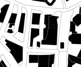
4 FIGURE GROUND ANALYSIS

5 CURVILINEAR TYPOLOGY IRREGULAR GRID PATTERN BROKEN APART BY CURVILINEAR RIVER TO ESTABLISH EDGES Of GRID. OPEN SPACES ARE DEFINED BY THE BUILT FORM GRID AND CURVILINEAR MOVEMENT PATTERN CHARACTERIZED BY URBAN GRID AND CURVILLINEAR RIVER. DIVERSITY OF BUILT FORM -Morphological dimension - Modular block along the grid line Pathway of pedestrian access and spaces of activity all has its own set back.
6 URBAN GRAIN COARSE GRAIN Large and infrequent - Street block of different size and configuration


7 1. CONTEMPERORY - Pre-shaped parcels (plot size) forming a pattern determined by use, and arrange in an organic form with appropriate spacing, bulk, and vertical dimension. Large building lots were placed irregular on the planned grid, Height and façade all irregular but the land use were almost all similar 2. TRADITIONAL = the field of blocks forms a carpet pattern of recognizable coherent textures that define a center. orderly space of smaller lots in fragmented parallel TYPOLOGY
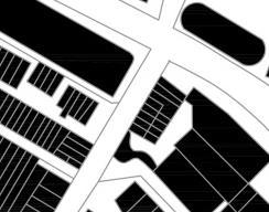
8
9 COLLAGE CITY
10 Scales of the street Strict to Ease


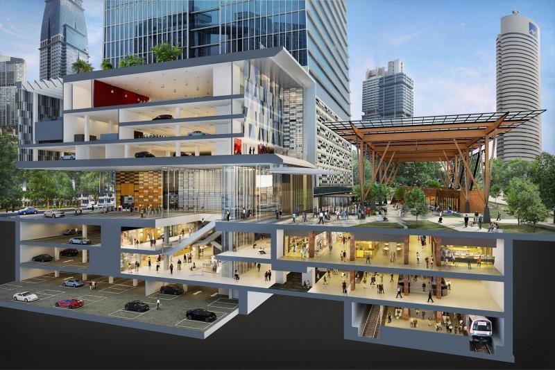
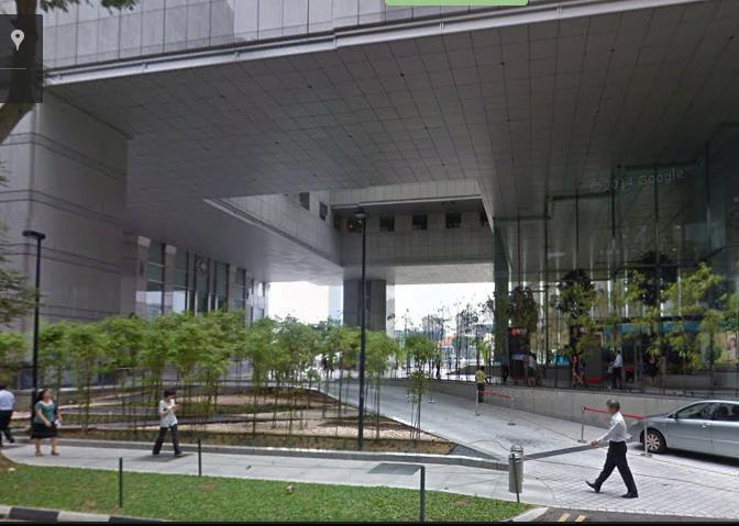
11 This space between building are wider. show that these space are mainly catered for vehicular access rather than pedestrian circulation

12 LAND USE DENSITY -- Overall site provide reasonable public spaces along the Church street - Towards South east of the church street, the Marina Blvd, there are plenty of spaces, this places represent car park, retails, commercial, office development
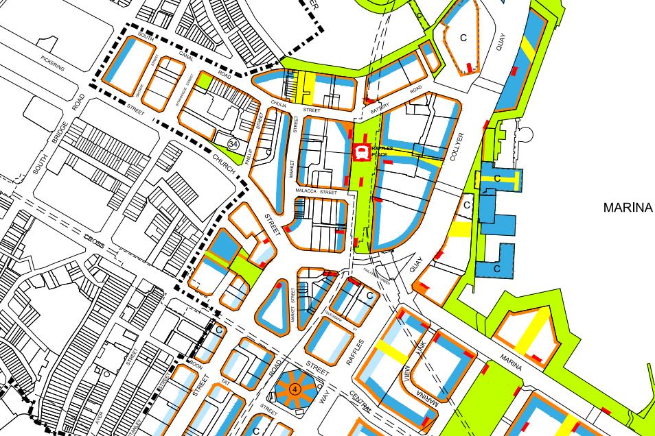
13 The CBD is predominantly zoned for Commercial use to ensure a critical mass of office uses to reinforce the positioning of the area as Singapore s core business and financial centre. To enliven the CBD, complementary supporting uses (e.g. hotel and residential) can be considered at the fringe areas. Beside the edge of commercial district. Kevin lynch s edge define different district

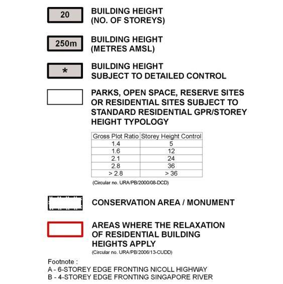
14 SCALE HEIGHT MASSING
15 Public surveillance Social dimension formal restricted to time frame Security Density of pedestrian usage
16 Weekdays active between working hour only - Not safe after working hours Weekends - Active most of the time. - Compare to weekdays it is more compact on weekends
17 SPATIAL ARRANGEMENT - ACTIVITY

18 Functional Dimension Spatial To create vibrant precincts formal, professional, attractive and pedestrian-friendly streets, activity-generating uses, such as retail, food & beverage, entertainment, sport and recreation (such as gymnasiums and fitness centres, etc.) and other similar uses are to be provided at the following locations: The 1st storey of developments fronting key streets, pedestrian malls and public spaces; and Alongside the underground pedestrian links at the basement levels of the developments are also encouraged alongside elevated pedestrian links The car park will put behind the building or hide by the façade to create a vibrant of formality The plinths of the city are the ground floors that negotiate between the inside and the outside, between the public and the private: this is the city at eye level. Plinths are extremely important for the urban experience, which in turn is an important driver for the urban economy. As for the context with modern high rise urban character, the directness of the pedestrian connection to the building is integrated into thoroughfare street side with stoops, arcades and cafe.
19 3 2 1 OPEN SPACES ANALYSIS


20 LINEAR INTERSTITIAL SPACE LEADING DIFFUSED INTERSTITIAL SPACE ALLOW PEDESTRAIN HAD A REST OR GATHER ENCLOSED INTERSTITIAL SPACE SECURE
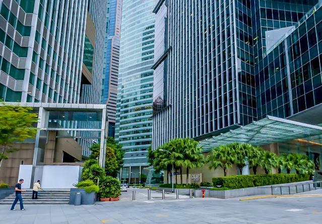
21 MOVEMENT PATTERN
22 GRID - Curvilinear Loop Pattern along river frontage -Conventional Grid Pattern continuous of the urban grid Layout Structure
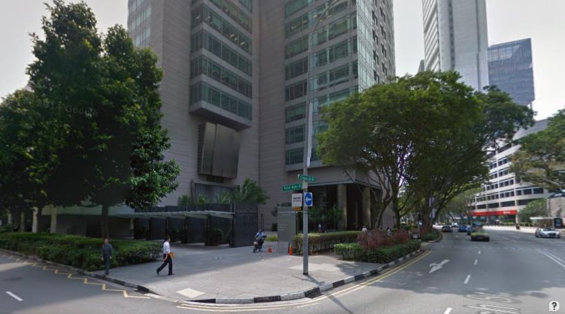
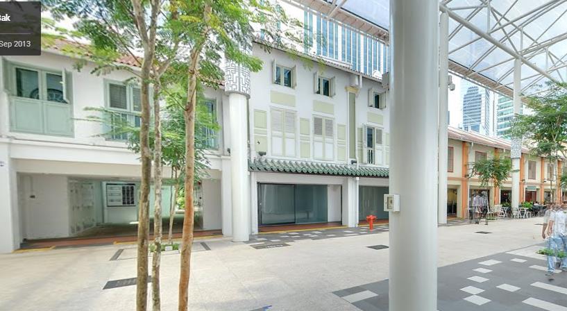
23 Spatial structure - Main road is connected with the MRT station
24 The busy area due to main road giving priority to vehicular access over pedestrian access makes it difficulties expansion as permeability is restricted to certain points. - FORMAL MOVEMENT PATTERN RESTRICTED THE ACESSFROM BOTH SIDE OF THE STREETS. - This space between building are wider. show that these space are mainly catered for vehicular access rather than pedestrian circulation The continuity of many path is disrupted by Church street - This paths within the town centre demonstrate free flow of movement regardless of traffic barriers - It is also clear that this area caters towards pedestrian circulation not only for the numerous public spaces but the tighter alignment of building for limited vehicular access. Selected developments provide through-block links or view corridors to break down the scale and improve permeability of the street block. Permeability Good permeability -Direct link with many short travel distance - No dead ends but with lots of route option
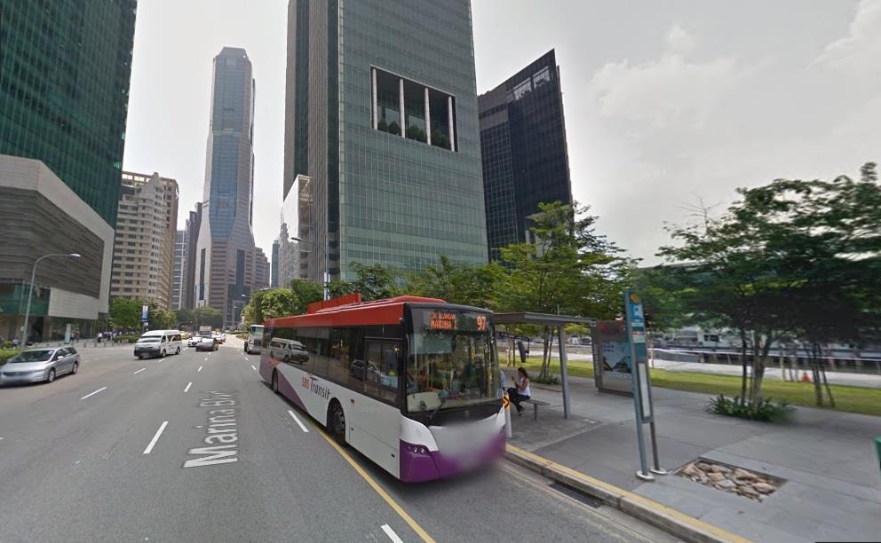
25 Serial Vision
26
27 FORM STRICT TO CASUAL
28 Street view point 1: The formal city of Rigidity 1

29 Street view point 1 : The Dense and Compactness of the Buildings The tall buildings are close to one another and separate by the traffic road. The consistent arrangement of buildings make the typology looks formal. F1

30 Street view point 2: The Ideal City of Perfection At the road junction, the building apex at the corner is not as edgy as the building along the street, thus giving a feeling of comfortable when turning around the corner. 2

31 Street view point 2 : The Contrast in Proportion The contrast of contemporary high rise building around with Raffles MRT station which is one of the few historical building at Marina commercial center. F2 The surrounding area show contrast in building proportion between MRT station and high rise building around.

32 Street View Point 3: The Difference in Hierarchy of buildings The hierarchy of buildings along this street shows high rise building skyline at the front part of the street and more low rise building skyline at the later part of the street. The changing of hierarchy shows the city typology. 3
33 ACTIVITIES - LIVE,WORK, PLACE
34 Street view point 1 1

35 A1 Street View Point 1 : Combination of works, plays and live make the site more lively and freedom. Contrast of activities at the Marina Boulevard which is a business centre while Marina Bay Sands plays the role in entertainment activities. Formal & orderly routine is found in the business centre while at the area in Marina Bay sands has a more chaotic routine.

36 1 Street View Point 2

37 Street View Point 2 : Combination of works, plays and live make the site more lively and freedom. A2 Majorly, there are two types of activities which is outdoor activities ( recreation activities - cycling, jogging, fishing, transportation and pedestrian. The cycling path acts as a transition space that consists of soft scape with trees and bushes.

38 Street View Point 3 3


39 A3 Street View Point 3 : Combination of the soft scape with the hard scape neutralize the environment to be more lively.

40 Connection of building and softscape was shown in these 3 pictures. The cycling path along the buildings create a public space for people to carry out various outdoor activities, while the sculpture around the tall building smooth out the hard landscape and brings attraction to the area.

41 Street View Point 4 4

42 Street View Point 4 : Combination of the activities of work and relax. There are several distinguish sculptures and historical buildings that act as landmarks at the site of the MRT station & significant enough to attract people to the site for photography and recreation, hence not even a small open space in between the building is wasted.

43 5 Street View Point 5

44 5A Street View Point 5 : Showing the life of the workers at the site about how and where they spending their leisure time. The food court beside the main road is the only public food centre for the area. It acts as a public gathering spaces for the office workers around.

45 Street View Point 6 6

46 6A Street View Point 6 : The soft-scape combine with the hard-scape neutralise the environment to be more lively. The pathway in front of the building beside the busy roadside lead the community into the building. Commonly, there are more attractive landscape architecture at the lower building to neutralize the compactness of the high rise buildings.

47 7 Street View Point 7
48 Street View Point 7 : The connection spaces giving a freedom to the workers access to the neighborhood. A7 The spaces within the commercial building and the historical building act as a connector of business activities which represent by contemporary buildings and commercial activities which represent by buildings at China street at the back of contemporary buildings.


49 The journey of this street commence with a grand opening, hence giving a panoramic view & an overall view of the streetscape. The latter of the street is embrace with softscape of greeneries and individual building function of private and public spaces as the road converging further. Further down the street, there is a turning point where the road pattern is diverge into smaller spaces of more private with less open spaces & activities.
50 7 OBJECTIVE


51 Character The scale, texture and colour of building materials reflects an area s special function and character. The existing layout of an area reflects its history, functions and connections with adjoining areas. Senses -Modern/simplicity/clear -Transparency/reflective -Smooth - Neat and Clean appearance Inviting -Stimulate your imagination& curiosity
 to promote the continuity of street")

52 Continuity (A place where public and private spaces are clearly distinguished) to promote the continuity of street frontages and the enclosure of space by development which clearly defines private and public areas. CONTINUOUS SIDE WALK

53 Enclosure Buildings which follow a continuous building line around a street block and contain the private space within back yards or courtyards are often more successful than individual buildings that stand in the middle of a site. Buildings with live edges, such as shop fronts, doors directly to the street, or residential upper floors, enable people to keep an eye on public space and make it feel safer Building entrances that are clearly identifiable contribute to the ease of understanding a place. Entrances are where people move between public and private space and create activity on the street. Direct access to the street from ground floor premises rather than by way of communal entrances, can reduce the length of blank facades.

54 Quality of the Public Realm This area immediately fronting the waterfront along Marina Boulevard is used as an interim event space and public gathering space during major national events, such as the Marina Bay Countdown every 31st December. The Marina Bay FUNCTIONAL DIMENSION


55 LEGIBILITY Landmark Gateway Focal point to promote legibility through development that provides recognizable routes, intersections and landmarks to help people find their way around. (Landmarks, gateways and focal points help people find their way. Vistas create visual links between places. Planting can emphasize pedestrian routes. Visible routes and destinations, and a visible choice of routes, will contribute to making a place feel safe and unthreatening. Places where form, layout and signage make them easy to understand are likely both to function well and to be pleasant to live in or visit.)
56 to promote adaptability through development that can respond to changing social, technological and economic conditions. Places should be capable of being used for a range of activities. Well-designed public spaces allow for different uses, such as events, festivals and markets at different time ( day lunch, gathering space night entertainment ) The central square in front of Raffles Place is always bustling with activities and events EXP FLASH MOP. Adaptability Raffles Place


57 mix of uses is achieved where the uses help to create a balanced community with a range of services, without increasing reliance on the car. Diversity
58 6 DIMENSION


access/ Traffic space- Underground MRT and MRT station such as")
59 Social dimension NECCESARY OPTIONAL SOCIAL Optional significant degree on what the place has to offer and how it makes people behave and feel about it TOURIST - walk around randomly at the restricted open space. Social ACTIVITY and event on the prearrange area Necessary public spaces function as meeting place, market place and access/ traffic space. Market placeunderground shopping mall (integrate with residential living)access/ Traffic space- Underground MRT and MRT station such as Raffles Place and Marina Bay WORKER know where to go everyday and all time is set

60 Visual dimension Temporal dimension Functional dimension Perceptual dimension
61 VISUAL DIMENSION Container, activity, historical significance, ambience The diffuse open space with the building blocks TEMPORAL DIMENSION -Designers have remarkable power to affect the perception of time by arranging objects in space, by setting dimensions, designing textures, selecting colors, and manipulating light PERCEPTUAL DIMENSION -On the identity of places: E Relph the essential quality of place was its power to order and to focus human intentions, experience, and behavior spatially Physical feature / appearance, observable activities and function and meaning / symbols. One of the identity of church street is the open ground floor accessibility for living, working and play which are convenient and ideal to not having edge only for a certain activity use. Raffles Place marks the identity of the street because by having the historical building incorporating with all the high rise building.
62 FUNCTIONAL DIMENSION Need in public space Comfort Sufficient seating place at the park and public open space at raffles place station. -relaxation Park for people to seek for liveliness and engagement with the city and its people. Natural feature such as tree are dominant factor to offer opportunity for retreat and relaxation shade cast by tree, enjoying the greenery allowing the public use of the park. Natural element such as water at the promontory allowed people to sit or stand there to enjoy the view. -passive and active engagement Passive engagement such as street corner that involves looking rather than talking and doing. People tends to sit at the water fountain to just sit and look at the passer by. The public art at the raffles place create a passive engagement with the public. It shows the concern the physical and aesthetic quality of site involve viewing public art or compelling landscape. Active engagement at the marina bay has provide an active recreational need, the jogging path, bicycle lanes are from of active use. Ceremony, celebration and festivity are qualities people seek in urban place. The Hong Lim park has full fill people need of joyousness to refresh their life. During public speaking, people will gather at the public park. -discovery The desire of stimulation and delight of new, pleasurable experience. The major aspects of discovery are diversity in physical design and the changing vistas.

63 Modular block along the grid line Pathway of pedestrian access and spaces of activity all has its own set back. Morphological dimension
64 The most significant feature of formal would be the balance in the city character, open ground floor that allow permeability and solid-void relationship that creates a good visual and diversity of the use and user. CONCLUSION SINGAPORE S CBD IS DESIGNED TO BE FORMAL. IN ITS FORM, MOVEMENT PATTERN AND ACTIVITY.
65 Tales of Wish CHIN YIN HUEI Compare to others cities, I'll prefer Singapore as they have more concern about the permeability and accessibility between pedestrian to the public realm. Besides, the city also have emergence of conservation resulted in an increased concern and respect for the uniqueness of places and their history and in large part was instrumental in the evolution of the contemporary concept of urban design, which attempts to respond to the exiting sense of place. TAN LAY SHANG i like the city of Singapore because it is well panned with good public transport, building form and space connectivity. The preservation of the historical building by remain it facade and change it function has completely make the city to be balance in term of the old and new. CHUAH CHU YING I would like to choose Singapore as my favorite city because of its well city planning with good public transportation and well connected pedestrian walkway which is much more safer and convenience to the citizen. Besides, their good urban city design with clean and neat building façade is very inspiring me to the city
66 Tales of Wish ELEANOR NG CUI SHAN I like Singapore because it's a city of green, a green city that have designated system that enable people to not only experience the hard scape but the soft scape as well with the greeneries all around the small island. The Singapore city reduces the carbon footprint.the form,open spaces and transportation in Singapore are well planned and convenient which include the MRT and bus. KHOO CHEE MEI I like the city of Singapore because has convenient transportation and integration between public and private spaces is good. The transition of spaces between open and closed area is surprisingly smooth. Moreover, the planning of zoning and spatial organization is well planned and organized.
67 THANKS FOR LISTENING Chin Yin Huei Tan Lay Shang Chuah Chu Ying Eleanor Ng Khoo Chee Mei
Policies and Code Intent Sections Related to Town Center
 Policies and Code Intent Sections Related to Town Center The Town Center Vision is scattered throughout the Comprehensive Plan, development code and the 1994 Town Center Plan. What follows are sections
4.0 Design Guidelines For The Village Centre. South fields Community Architectural Design Guidelines Town of Caledon
 4.0 Design Guidelines For The Village Centre 4.0 Design Guidelines for the Village Centre The Village Centre is the focal point of the entire South Fields Community and is designed as a traditional commercial
East Bayshore Road Neighbourhood
 East Bayshore Road Neighbourhood Northridge Property Management Urban Design Brief 3195 East Bayshore Road City of Owen Sound January 2016 East Bayshore Road Neighbourhood Northridge Property Management
PUBLIC RIGHT-OF-WAY IN THIS CHAPTER PUBLIC REALM
 PUBLIC RIGHT-OF-WAY This section provides design guidelines for improvements in the public right-of-way. The public right-of-way refers to streets, sidewalks, non-vehicular thoroughfares, parks and greenways
Colchester Northern Gateway Master Plan Vision Review Draft. July 2016
 Colchester Northern Gateway Master Plan Vision Review Draft July 2016 Contents Introduction 4 Context 8 Purpose of the Report 8 Strategic Position 9 Overview of the Process 11 2012 Master Plan Vision 12
4.0 URBAN DESIGN FRAMEWORK. The vision for the future development of the plan area is to:
 4.0 The vision for the future development of the plan area is to: Create a new neighbourhood that focuses on the highly valued natural and aesthetic features of the lands and provides good quality homes,
URBAN DESIGN BRIEF URBAN DESIGN BRIEF 721 FRANKLIN BLVD, CAMBRIDGE August 2018
 URBAN DESIGN BRIEF URBAN DESIGN BRIEF 721 FRANKLIN BLVD, CAMBRIDGE August 2018 DESIGN BRIEF CONTENTS PART A 1.0 INTRODUCTION 2.0 DESCRIPTION & ANALYSIS OF SITE CONTEXT 3.0 DESIGN CONSTRAINTS AND OPPORTUNITIES
appendix and street interface guidelines
 appendix five: building and street interface guidelines appendix 5 building and street interface guidelines BOULEVARDS Boulevards are generally characterized by higher levels of traffic movement at higher
PART AOTEA PRECINCT
 CONTENTS... PAGE AOTEA PRECINCT...4 14.5.1 INTRODUCTION...4 14.5.2 RESOURCE MANAGEMENT ISSUES...4 14.5.3 RESOURCE MANAGEMENT OBJECTIVES AND POLICIES... 4 14.5.4 RESOURCE MANAGEMENT STRATEGY...5 14.5.5
Page 1 of 19 URBAN DESIGN FRAMEWORK FOR BOLTON STREET WATERFORD
 Page 1 of 19 URBAN DESIGN FRAMEWORK FOR BOLTON STREET WATERFORD 1.0 Introduction: The relocation of the City Council stores and depot from Bolton Street creates an exciting opportunity for development
Urban Design Manual PLANNING AROUND RAPID TRANSIT STATIONS (PARTS) Introduction. Station Study Areas
 Introduction. Station Study Areas") 111111 PLANNING AROUND RAPID TRANSIT STATIONS (PARTS) Introduction The ION rapid transit system will link Waterloo, Kitchener and Cambridge through a central transit corridor (CTC). There are a number
111111 PLANNING AROUND RAPID TRANSIT STATIONS (PARTS) Introduction The ION rapid transit system will link Waterloo, Kitchener and Cambridge through a central transit corridor (CTC). There are a number
New-Cast Mixed-use Development Proposal King Street West, Newcastle, Ontario
 URBAN DESIGN BRIEF New-Cast Mixed-use Development Proposal King Street West, Newcastle, Ontario TABLE OF CONTENTS: 1.0 Executive Summary 2.0 Creating Vibrant and Sustainable Urban Places: Excerpts from
Regency Developments. Urban Design Brief. Holyrood DC2 Rezoning
 Regency Developments Urban Design Brief Holyrood DC2 Rezoning Stantec Consulting Ltd. 7-31-2017 1. Overview Regency Developments intends to rezone the lands located at 8510 and 8511 93 Avenue, within the
B L A C K D I A M O N D D E S I G N G U I D E L I N E S for Multi-family Development
 B L A C K D I A M O N D D E S I G N G U I D E L I N E S for Multi-family Development Adopted June 18, 2009 This section of the Design and focuses on site planning and design guidance for new multi-family
3.1 Existing Land Use
 3.0 Land Use This strategy has been developed taking into account the position of the Town of Sidney as the economic center of the Saanich Peninsula. It acknowledges existing land use patterns in the downtown
Complete Neighbourhood Guidelines Review Tool
 Complete Neighbourhood Guidelines Review Tool Prepared By: City of Regina Planning Department October 2014 Page 1 of 14 Community Development Review Checklist for Secondary Plans and Concept Plans The
97 Lea Bridge Road, Leyton, E10 7QL London Borough of Waltham Forest December 2015
 97 Lea Bridge Road, Leyton, E10 7QL London Borough of Waltham Forest December 2015 Public Realm and Landscape Proposals LEA BRIDGE ROAD, WALTHAMSTOW Public Realm & Landscape Proposals BDP(90)RPT001 December
INSTITUTIONAL USE DESIGN COMPATIBILITY TECHNIQUES
 INSTITUTIONAL USE DESIGN COMPATIBILITY TECHNIQUES INTRODUCTION Community institutions are an important part of the character and vitality of neighborhoods in Forsyth County. Institutional uses include
3.1 community vision. 3.3 required plan elements
 Chapter 3 Community Form 3.1 community vision 3.2 Parks & landscaping concepts 3.3 required plan elements D R A F T 20 Community Form Chapter 3 3.0 Community form 3.1 community vision The Specific Plan
Keystone Business Park Precinct Structure Plan North East Industrial Precinct. Part 2 Design Principles
 Keystone Business Park Precinct Structure Plan North East Industrial Precinct Part 2 Design Principles Context Issues Services Landform Issues Geotech and contamination Ecology Traffic and access Issues
Design Guidance. Introduction, Approach and Design Principles. Mauritius. November Ministry of Housing and Lands. .. a
 sig evelo r D Mauritius s. Utilities.. Individu a s. er itects.to ls chpers.po e Public. T. h rban D Sc U e me Promot e h ners. A Design Guidance o.h Planne rs n w iticians r l useholde National Development
URBAN DESIGN BRIEF. 2136&2148 Trafalgar Road. Town of Oakville
 URBAN DESIGN BRIEF 2136&2148 Trafalgar Road Town of Oakville Prepared By: METROPOLITAN CONSULTING INC For 2500674 Ontario Inc November 2016 TABLE OF CONTENTS Page No. 1.0 Introduction/Description of Subject
GUIDING PRINCIPLES IN THIS CHAPTER
 GUIDING PRINCIPLES The guiding principles and design concepts in this chapter work together with the Chapel Hill 2020 Comprehensive Plan to support new public places that can be enjoyed by all while also
SQUAMISH 2010 AND BEYOND COMMUNITY VISION
 Our plan has been imagined and created to be both pragmatic and visionary. At the core of the strategy is a consideration of the highway s role and its impact on the community. First and foremost in creating
A Vibrant Downtown. Chapter 5 Cary Public Art Opportunities 31
 A Vibrant Downtown Cary s vision for Downtown is a unique, vibrant, dynamic, pedestrian friendly location; a regional destination and a place to live, work, and recreate, according to the 2001 Town Center
CAL POLY MASTER PLAN UPDATE, March 2015
 Some Key Themes in the General Guiding Principles Academic Mission The plan must foremost advance the University s academic mission and student success. Foresight and Adaptability The plan should take
Cit of Kitchener Ur 6 an Design Manual PARTA. Desi n for _--::
 Cit of Kitchener Ur 6 an Design Manual Date PARTA Year ) Desi n for k Nodes Corridors _--:: Section Page 01 of 12 2 INTRODUCTION Purpose & Application Nodes and Corridors have been identified as key intensification
McCowan Precinct Plan Study Background & Deliverables
 1 DRAFT & WITHOUT PREJUDICE McCowan Precinct Plan Study Background & Deliverables In September, 2011, City Planning (Scarborough District) began a study of an area within the Scarborough Centre, identified
5.1 Site Plan Guidelines
 5. Community Core Guidelines Development of the Community Core will take place by plan of subdivision and site plan approval. It will occur in a phased manner that will reflect the timing of residential
ILLUSTRATIVE MASTERPLAN
 ILLUSTRATIVE MASTERPLAN The Development Dairy Crest (Imperial College) The Proposed Development aims to create a new high quality residential neighbourhood, alongside a new public park for White City.
PUBLIC REALM STUDY AREA
 WELCOME PUBLIC REALM STUDY AREA WHAT IS PUBLIC REALM? Welcome to the Ballina Town Public Realm public consultation event. Mayo Council is in the process of producing a Public Realm Strategy for Ballina
Woodbrook - Shanganagh
 Section 4: Key Sites Framework Strategy Woodbrook - Shanganagh Local Area Plan 2017-2023 4. Site Framework Strategies The Master Plans shall have regard to the thematic objectives under the LAP Development
Figure 3-1: Public Realm Plan
 3 Public Realm Figure 3-1: Public Realm Plan 3.1 Public Realm Concept The public realm concept for the Little Mountain site integrates a clear and accessible movement network with public spaces for social
EXISTING COMPREHENSIVE PLAN
 EXISTING COMPREHENSIVE PLAN Town Center Land Use Element: V. LAND USE POLICIES Town Center Mercer Island's business district vision as described in "Your Mercer Island Citizen-Designed Downtown" was an
Community Design Plan
 Gardena General Plan 2006 Authority While the is not a required element of a General Plan, it is included because improving the community appearance and image is paramount to the overall quality of life
Buildings may be set back to create small plazas provided that these setbacks do not substantially disrupt the street wall s continuity.
 6-22 Community Design Street Walls and Street-front Setbacks The siting of buildings will play a critical role in establishing the character and sense of place for the District. Siting buildings at the
(DC1) Direct Development Control Provision DC1 Area 4
 Direct Development Control Provision DC1 Area 4") . General Purpose (DC) Direct Development Control Provision DC Area 4 The purpose of this Provision is to provide for an area of commercial office employment and residential development in support of the
. General Purpose (DC) Direct Development Control Provision DC Area 4 The purpose of this Provision is to provide for an area of commercial office employment and residential development in support of the
ELMVALE ACRES SHOPPING CENTRE MASTER PLAN
 ELMVALE ACRES SHOPPING CENTRE MASTER PLAN Contents 1.0 INTRODUCTION... 2 2.0 LOCATION... 2 3.0 EXISTING CONTEXT... 2 4.0 VISION & GUIDING PRINCIPLES... 2 5.0 LAND USE AND BUILT FORM... 4 5.1 St. Laurent
WEST BLACKHALL STREET PUBLIC REALM + TOWN CENTRE CONNECTIONS Public Exhibition 28 th June 2018
 WEST BLACKHALL STREET PUBLIC REALM + TOWN CENTRE CONNECTIONS Public Exhibition 28 th June 2018 Welcome Introduction Design Your Involvement Thank you for coming Engagement We would like to gather to this
The Proposed Auckland Unitary Plan (notified 30 September 2013)
") 3 Business zones Introduction There are 10 business zones in the Unitary Plan: City Centre Metropolitan Centre Town Centre Local Centre Neighbourhood Centre Mixed Use General Business Business Park Light
3 Business zones Introduction There are 10 business zones in the Unitary Plan: City Centre Metropolitan Centre Town Centre Local Centre Neighbourhood Centre Mixed Use General Business Business Park Light
APPENDICES DESIGNING PUBLIC SPACES - ENERGIZED PUBLIC SPACES DESIGN GUIDELINES WORKING DRAFT DECEMBER 2018 A1
 APPENDICES DESIGNING PUBLIC SPACES - ENERGIZED PUBLIC SPACES DESIGN GUIDELINES WORKING DRAFT DECEMBER 2018 A1 App.1 Case Studies by Park Types The upcoming (in-progress) online library will house several
[PLANNING RATIONALE] For Site Plan Control and Lifting of Holding Zone By-Law 101 Champagne Avenue. May 23, 2014
![[PLANNING RATIONALE] For Site Plan Control and Lifting of Holding Zone By-Law 101 Champagne Avenue. May 23, 2014](/thumbs/75/71599615.jpg "[PLANNING RATIONALE] For Site Plan Control and Lifting of Holding Zone By-Law 101 Champagne Avenue. May 23, 2014") [PLANNING RATIONALE] For Site Plan Control and Lifting of Holding Zone By-Law 101 Champagne Avenue May 23, 2014 Contents 1.0 Introduction... 2 2.0 Site Context... 2 2.1 Adjacent Uses... 2 Figure 1: Site
[PLANNING RATIONALE] For Site Plan Control and Lifting of Holding Zone By-Law 101 Champagne Avenue May 23, 2014 Contents 1.0 Introduction... 2 2.0 Site Context... 2 2.1 Adjacent Uses... 2 Figure 1: Site
VEHICULAR AND PEDESTRIAN CIRCULATION
 This perspective sketch communicates the intended character and quality of a proposed streetscape design. Locate benches near a major intersection where people tend to gather. Seating and lighting provide
V. Gateways GATEWAYS / V-1
 V. GATEWAYS / V-1 Many of Chesapeake s gateways are located on highways and call for bold and attractive designs that motorists can understand, appreciate, and enjoy. can also take the form of natural
Bel-Air Lexus Automobile Service Station
 Bel-Air Lexus Automobile Service Station Design Brief 443-447 McArthur Avenue Ottawa April 30, 2015 14-1299-MCA Site Details Application: Site Plan Control Legal Description and Municipal Addresses: 443
DRAFT DESIGN GUIDELINES
 IHZ Booklet #7 May 6, 2010 DRAFT DESIGN GUIDELINES CANTERBURY 7 Overview During the recent planning process for the Plan of Conservation and Development community character was identified as an important
PROPOSED REDEVELOPMENT OF THE GLEN ABBEY GOLF CLUB. STREETSCAPE DESIGN STUDY (excerpt from the Urban Design Brief) TOWN OF OAKVILLE.
 TOWN OF OAKVILLE.") PROPOSED REDEVELOPMENT OF THE GLEN ABBEY GOLF CLUB STREETSCAPE DESIGN STUDY (excerpt from the Urban Design Brief) TOWN OF OAKVILLE OCTOBER, 2016 for 2.4.2 STREETS Streets are the single largest component
PROPOSED REDEVELOPMENT OF THE GLEN ABBEY GOLF CLUB STREETSCAPE DESIGN STUDY (excerpt from the Urban Design Brief) TOWN OF OAKVILLE OCTOBER, 2016 for 2.4.2 STREETS Streets are the single largest component
DRAFT. October Wheaton. Design Guidelines
 October 2011 DRAFT Wheaton Design Guidelines 2 Draft - Design Guidelines - Wheaton Sector Plan Contents 04 Section 1: Introduction 06 Section 2: Context 08 Section 3: Design Guidelines 09 Goal 1: Create
Chapter 3: Office & Office Mixed-Use Project Types
 Chapter Contents Purpose... 3-2 Applicability and Use Types...3-3 (1) Site Design...3-4 Building Placement and Orientation...3-5 Circulation and Vehicle Parking...3-6 Bicycle/Pedestrian Amenities...3-8
Housing Development at Balloonagh Tralee Co Kerry
 Design Statement Housing Development at Balloonagh Tralee Co Kerry Area of site 10,400m2 24 houses-12no 3 bed, 12no 2 bed and 4 single bed apartments total residential area of 2411m2 Open space provided
Community Design Guidelines. Port Wallace DRAFT
 Community Design Guidelines Port Wallace DRAFT Energy 1 2 3 Nature Movement Connections Built Form DRAFT Layout Energy 1 Nature Community Design Guidelines GREAT COMMUNITIES PROTECT, CELEBRATE, AND CONSERVE
City of Farmington. Downtown Plan. Amendment to the 1998 Master Plan Adopted October 11, 2004
 City of Farmington Amendment to the 1998 Master Plan Adopted October 11, 2004 Introduction Planning Background 1 Scope and Components of the Plan Amendment 2 Concept Introduction 3 Plan Concepts 3 Conceptual
UNIVERSITY TOWN NEIGHBOURHOODS 5.5 HOUSING MELBOURNE CAMPUS MASTER PLAN 2014
 5.5 169 EXISTING CONDITIONS & VISION NEIGHBOURHOOD VISION The provision of on-campus housing into the future will continue to be an important element of the La Trobe University experience. A long-term
Courthouse Square Planning & Urban Design Study. Courthouse Square Working Group #13 October 15, 2014
 Courthouse Square Planning & Urban Design Study Courthouse Square Working Group #13 October 15, 2014 1 Courthouse Square Process Working Group Community Courthouse Square Advisory Groups & Civic Associations
Ivywild On The Creek PRELIMINARY CREEK DISTRICT MASTER PLAN
 Ivywild On The Creek PRELIMINARY CREEK DISTRICT MASTER PLAN Introduction: Rejuvenating an extraordinary Creekside neighborhood THE CREEKSIDE DISTRICT The Ivywild On The Creek Neighborhood District Master
8.0 Built Form Framework
 Figure C-40. RIC and Laboratory Building Internal Pedestrian Node 8.0 Built Form Framework The built form framework defines the desired future character and function of built elements within the campus
Throughout. square. (Crystal City Vision Plan 2050)
") 1: Terms related to the PSMP document 1 public space (see also public realm, civic space) An open space designated on the regulating plan, accessible to all, including Plazas, Mini Parks, and Neighborhoods
1: Terms related to the PSMP document 1 public space (see also public realm, civic space) An open space designated on the regulating plan, accessible to all, including Plazas, Mini Parks, and Neighborhoods
Urban Design Guidelines
 Urban Design Guidelines These Urban Design Guidelines comprise the Key Design Objectives below, the Roads Design Guidelines overleaf and Neighbourhood Framework Plans. Together with Section 3: Urban Design
Tel: (705) Fax: (705)
 Fax: (705)") 521 and 525 Essa Road City of Barrie Tel: (705) 812-3281 Fax: (705) 812-3438 Email: INFO@IPSCONSULTINGINC.com 1 5 0 D U N L O P S T R E E T E A S T, S U I T E 2 0 1, B A R R I E O N T A R I O L 4 M 1 B
521 and 525 Essa Road City of Barrie Tel: (705) 812-3281 Fax: (705) 812-3438 Email: INFO@IPSCONSULTINGINC.com 1 5 0 D U N L O P S T R E E T E A S T, S U I T E 2 0 1, B A R R I E O N T A R I O L 4 M 1 B
Clairtrell Area Context Plan
 Clairtrell Area Context Plan March 2005 Urban Development Services City Planning Contents 1. Introduction... 4 2. Development Structure... 6 2.1 Streets... 7 2.1.1 Sheppard Avenue and Bayview Avenue...
Town Center (part of the Comprehensive Plan)
") Town Center (part of the Comprehensive Plan) Mercer Island Town Center Looking North (2014) In 1994, a year-long process culminated in a set of design guidelines and code requirements for the Town Center
Town Center (part of the Comprehensive Plan) Mercer Island Town Center Looking North (2014) In 1994, a year-long process culminated in a set of design guidelines and code requirements for the Town Center
Section 4 - Public Realm & Landscape proposals Landscape Masterplan. Section 4 52
 - Public Realm & Landscape proposals Landscape Masterplan 52 Proposed Masterplan - Green Infrastructure Strategy District Park 4.33 Ha to provide Passive and active recreation with a large play area which
1.0 VISION STATEMENT. December 6, PRINCIPLES
 Vision Statement Lincoln Regional Airport 1.0 VISION STATEMENT 1.1 City LOCATION of AND OVERVIEW The Easton Lincoln Place Land Use Master Plan identifies the principles, goals, policies, and standards
LOW DENSITY RESIDENTIAL
 LOW DENSITY RESIDENTIAL Corner lots with coach houses to increase diversity, provide unity to the streetscape and increase eyes on the street. Garages and ancillary units accessed via rear lanes. Parking
VILLAGE OF SKOKIE Design Guidelines for Mixed-Use Districts NX Neighborhood Mixed-Use TX Transit Mixed-Use CX Core Mixed-Use
 VILLAGE OF SKOKIE Design Guidelines for Mixed-Use Districts NX Neighborhood Mixed-Use TX Transit Mixed-Use CX Core Mixed-Use TABLE OF CONTENTS CHAPTER 1 SITE DESIGN Purpose 1 CHAPTER 2 SITE DESIGN Streetscape
V. Vision and Guiding Principles
 V. Vision and Guiding Principles The Master Plan for the Powers Ferry Corridor seeks a foundation in the desires of the community. At times, various elements of the community offered opposing viewpoints,
Design and Access Statement Volume I Part 7 of 9 Masterplan. May 2018 Allies and Morrison
 Design and Access Statement Volume I Part 7 of 9 Masterplan May 2018 Allies and Morrison 4.3 Central Cluster 303 CANADA WATER MASTERPLAN Design and Access Statement May 2018 4.3 Central Cluster L H K
WEST LOOP DESIGN GUIDELINES CHECKLIST
 WEST LOOP DESIGN GUIDELINES CHECKLIST Section 1.0 General Strategies 1.1 DESIGN EXCELLENCE: ENCOURAGE HIGH QUALITY AND INNOVATIVE DESIGN OF NEW BUILDINGS WITHIN THE WEST LOOP WITHOUT BEING PRESCRIPTIVE
DESIGN GUIDELINES CITY OF OTTAWA
 DESIGN GUIDELINES CITY OF OTTAWA DECEMBER 17, 2015 BASED ON THE ISLES: DOMTAR LANDS REDEVELOPMENT MASTER PLAN DATED APRIL 22, 2014 AND PREPARED BY PERKINS+WILL ZIBI DESIGN GUIDELINES Prepared by FOTENN
Official Community Plan Bylaw No. 4360, 2004, Amendment Bylaw No. 4897, 2016 (Sewell s Landing)
") District of West Vancouver Official Community Plan Bylaw No. 4360, 2004, Amendment Bylaw No. 4897, 2016 (Sewell s Landing) Effective Date: 1089612v1 District of West Vancouver Official Community Plan Bylaw
District of West Vancouver Official Community Plan Bylaw No. 4360, 2004, Amendment Bylaw No. 4897, 2016 (Sewell s Landing) Effective Date: 1089612v1 District of West Vancouver Official Community Plan Bylaw
Deicke Richards Aug 2009 Rev A. Varsity Station Village A master plan for a TOD
 Deicke Richards Aug 2009 Rev A Varsity Station Village A master plan for a TOD Introduction The Varsity Station Village project is transforming empty governmentowned industrial land on Queensland s Gold
HIGHLAND VILLAGE GREEN URBAN DESIGN PRINCIPLES/GUIDELINES
 URBAN DESIGN GUIDING PRINCIPLES/GUIDELINES CONTEXT/CHARACTER The City of Calgary s Municipal Development Plan (MDP), Transit-Oriented Development (TOD) Policy Guidelines and Main Street/Corridor policy
FRUITVALE TRANSIT VILLAGE (Phase 2) Residential Project
 Residential Project") FRUITVALE TRANSIT VILLAGE (Phase 2) Residential Project DEVELOPER: SIGNATURE PROPERTIES ARCHITECT: HKIT ARCHITECTS April 23, 2010 TABLE OF CONTENTS 3 Vision 4 Description of Site 5 Guiding Concepts 6
FRUITVALE TRANSIT VILLAGE (Phase 2) Residential Project DEVELOPER: SIGNATURE PROPERTIES ARCHITECT: HKIT ARCHITECTS April 23, 2010 TABLE OF CONTENTS 3 Vision 4 Description of Site 5 Guiding Concepts 6
NORTHGATE AREA. Design Guidelines. Effective, final draft: 2 may 02. City of Seattle Department of Design, Construction & Land Use
 NORTHGATE AREA neighborhood urban village Design Guidelines Effective, final draft: 2 may 02 City of Seattle Department of Design, Construction & Land Use Design Review: Northgate Area Neighborhood Design
4 Proposed masterplan 4.1 Proposed masterplan: The scheme The scheme s component parts Urban form and grain
 4 Proposed masterplan 4.1 Proposed masterplan: The scheme... 36 4.2 The scheme s component parts... 36 4.2.1 Urban form and grain...36 4.2.2 Retail Circuits...38 4.2.3 Mix of uses...39 4.2.4 Public realm...40
lot flankage Y street 16m 6m landscape strip for large site 3m landscape strip for small medium site
 Commercial General Commercial Objectives Create developments compatible with adjacent land uses in scale, function and character Define a consistent and attractive street edge with quality landscaping,
CONTENTS 8.0 LAND USE 8.1 GENERAL LAND USE 8.2 RESIDENTIAL 8.3 MIXED USE 8.4 COMMERCIAL 8.5 EMPLOYMENT LANDS
 8-2 Land Use 8.0 LAND USE CONTENTS 8.1 GENERAL LAND USE 8.1.1 Uses provided for in all Land Use Designations 8.1.2 Uses prohibited in Hazardous Lands, Hazardous Sites and Special Policy Areas 8.1.3 Uses
Bayshore Boulevard Home Improvement District Design Guidelines
 Bayshore Boulevard Home Improvement District Design Guidelines guidelines for New construction projects and major alterations IN the bayshore boulevard home improvement special use DISTRICT SAN FRANCISCO
3.3. Urban Structure Defining a New Hierarchy of Routes and Spaces >Images
 Section 3.0 I The Masterplan Framework 18 >Images Examples of high quality routes and spaces 3.3. Urban Structure The success of any masterplan lies in a clear definition of the future urban structure
FLORIN ROAD CORRIDOR Site Plan and Design Review Guidelines Checklist
 FLORIN ROAD CORRIDOR Site Plan and Design Review Guidelines Checklist Applicant s Name: Project Address: Phone: Email: Applicant shall fill out the design guidelines checklist for all guidelines applicable
Wide asphalt driveway abutting school property. garage built with incompatible materials, too close to park. incompatible fencing materials
 Wide asphalt driveway abutting school property incompatible fencing materials garage built with incompatible materials, too close to park Lack of plantings as a buffer between private property and open
THE NEIGHBORHOOD TODAY
 THE NEIGHBORHOOD TODAY CORE AREA VISION How are we Good Urbanism A Site s DNA thinking about Elements of great Unique elements urban communities embedded in a place the site and design? ELEMENTS LIKE:
DESIGN GUIDELINES. Planning Commission Re-Submittal. December 23, 2014 Revised to include Mixed-Use Design District Guidelines
 DESIGN GUIDELINES Planning Commission Re-Submittal December 23, 2014 Revised to include Mixed-Use Design District Guidelines Table of Contents I. INTRODUCTION 4 II. PROJECT VISION 5 III. PRAIRIEFIRE DISTRICTS
Mixed Use Centres Development Permit Guidelines
 1 Mixed Use Centres Development Permit Guidelines Area Commercial or Mixed Use development occurring in City Centre, Urban Centre, Neighbourhood Centre, or Institutional Complex land use designations is
13. New Construction. Context & Character
 13. New Construction Context & Character While historic districts convey a sense of time and place which is retained through the preservation of historic buildings and relationships, these areas continue
PROPOSED URBAN STRUCTURE
 CHAPTER 3 PROPOSED URBAN STRUCTURE PLANNING PARTNERS: CENTURY CITY URBAN DESIGN FRAMEWORK October 2005 13 THE PROPOSED URBAN STRUCTURE The urban design rationale outlined in the previous chapter provides
The Village. Chapter 3. Mixed Use Development Plan SPECIFIC PLAN
 The Village SPECIFIC PLAN Chapter 3 3.1 INTRODUCTION 3.1.1 Purpose This Chapter describes the development regulations applicable to the Mixed-Use and Transit Center Planning Areas. These form-based regulations
WELLINGTON HOSPITAL DESIGN GUIDE TABLE OF CONTENTS
 WELLINGTON HOSPITAL DESIGN GUIDE TABLE OF CONTENTS 1.0 Introduction Page 2 The Place of Wellington Hospital 2 The Future of the Hospital 2 2.0 The Intention of the Design Guide 3 3.0 Analysis 4 General
Proposed for Vic West Neighbourhood Plan. Design Guidelines for Intensive Residential Development - Townhouse and Attached Dwelling
 Proposed for Vic West Neighbourhood Plan Design Guidelines for Intensive Residential Development - Townhouse and Attached Dwelling Design Guidelines for Intensive Residential Development - Townhouse and
22.15 OUTDOOR ADVERTISING SIGNAGE POLICY
 22.15 OUTDOOR ADVERTISING SIGNAGE POLICY This policy applies to all land where a planning permit is required to construct or display a sign under the provisions of the Kingston Planning Scheme. 22.15-1
2.0 Strategic Context 4
 2.0 Strategic Context 4 2.1 The Area Action Plan is a non-statutory plan, which forms a corporate policy document, expressing particular issues and areas of concern while also providing a vision for the
SOCIO-ECONOMIC MOVEMENT ENVIRONMENT INFRASTRUCTURE TOWN PLANNING
 Table 7: SWOT Analysis SWOT ANALYSIS SOCIO-ECONOMIC MOVEMENT ENVIRONMENT INFRASTRUCTURE TOWN PLANNING STRENGTHS HIGH COMMUTER POPULATION DENSITY MAJORITY OF POPULATION BETWEEN AGE OF 15 & 34 LARGE AVAILABLE
Appendix D: Rockbank Major Town Centre key design principles
 Appendix D: Rockbank Major Town Centre key design principles ATTRACTING INVESTMENT & SUPPORTING THE COMMUNITY Principle 1 Create a focal point for a diverse range of uses within the town centre that are
4 C OMMUNITY D ISTRICTS
 4 C OMMUNITY D ISTRICTS N ew development in the Area will include many different types of land uses, including a destination retail area that attracts people from all over the region; recreation opportunities
Market Place Bythell Place Queen Street Park Riverside Park. Public Spaces. Blenheim CBD Streetscape Final Report 36
 37 39 41 43 Market Place Bythell Place Queen Street Park Riverside Park Final Report 36 Market Place Market Place is a key space for Blenheim s street life, it is a meeting place, retail edge and pedestrian
2.1 Location and Size
 2.0 Context 7 2.1 Location and Size The Saanich Penninsula The study area is centrally located within the Town boundaries on the east side of Highway 17, which runs through Sidney in a north-south direction.
Urban Design Brief. Watson Parkway North & Watson Road North Guelph, Ontario. Prepared by Coletara Development
 Urban Design Brief Watson Parkway North & Watson Road North Guelph, Ontario Prepared by Coletara Development December, 2013 Urban Design Brief, Coletara Development 1 Introduction This Urban Design Brief
Mix of Uses Guide for Transit-Oriented Development MIX OF USES
 MIX OF USES Creating a Destination Magnet A diversity of uses such as retail, housing, offices, civic and entertainment within the TOD creates a destination magnet for transit users and TOD neighbors.
WINDSOR GLEN DESIGN GUIDELINES
 WINDSOR GLEN DESIGN GUIDELINES Adopted by Council, 2006 WINDSOR GLEN REDEVELOPMENT DESIGN GUIDELINES August 2006 1.0 Master Plan Organization For this area of the Coquitlam Town Centre, a mix of high,
Highland Village Green Design Guidelines
 Highland Village Green Design Guidelines Publishing Information Title Highland Village Green Design Guidelins Author The City of Calgary Status DRAFT - Proposed document subject to changes Additional Copies