FEASIBILITY REPORT EVERGREEN PARK AREA STREET, UTILITY AND TRAIL IMPROVEMENTS
|
|
|
- Chastity Gallagher
- 5 years ago
- Views:
Transcription

1 Public Works Dept Engineering Division Phone: FAX: FEASIBILITY REPORT FOR EVERGREEN PARK AREA STREET, UTILITY AND TRAIL IMPROVEMENTS IMPROVEMENT PROJECT NOS , 02, 03, 04 and 05 CITY OF BROOKLYN CENTER, MINNESOTA October 18, 2016 I hereby certify that this plan, specification or report was prepared by me or under my direct supervision and that I am a duly Licensed Professional Engineer under the laws of the State of Minnesota Michael J Albers, P.E. Reg October 18, 2016 Feasibility Report Evergreen Park Area Street, Utility & Trail Improvements Page 1
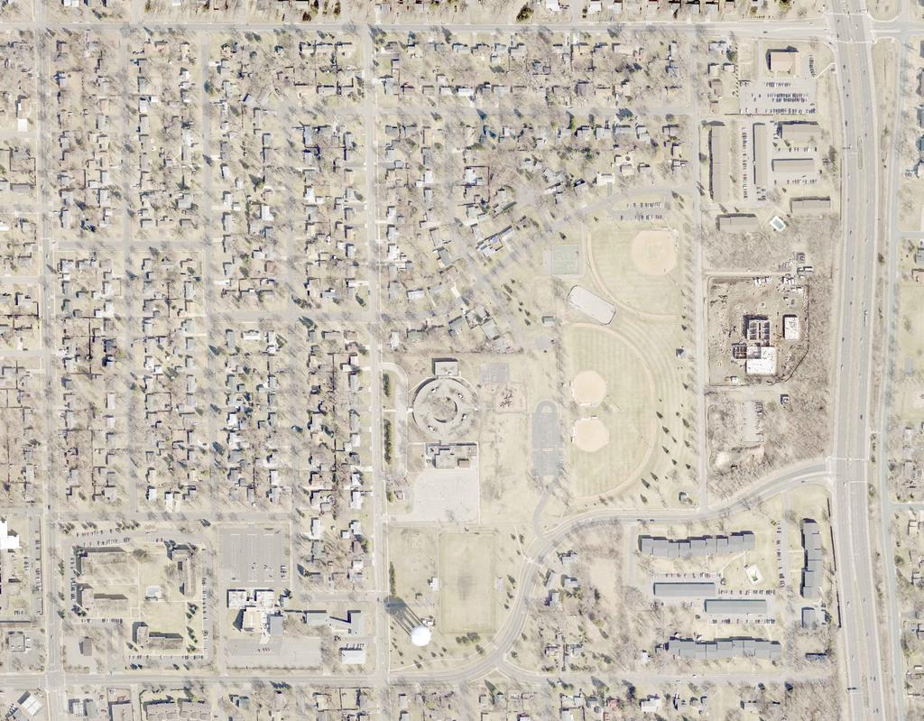
2 I. BACKGROUND In 2017, the City of Brooklyn Center will be entering the 24 th year of its long-range infrastructure rehabilitation program often referred to as the Neighborhood Street and Utility Improvement Program. This program has consisted of a systematic rehabilitation and/or replacement of the City s aging streets, water main, sanitary sewer, storm sewers, sidewalks, trails and street lights. In addition, other neighborhood improvements are often considered as part of the projects, including park improvements, landscape improvements and traffic control improvements. The City s Capital Improvement Program identifies the Evergreen Park Area Neighborhood for reconstruction in The proposed project includes roadway, utility, sidewalk and trail improvements within the project limits shown on Figure 1. The improvement area consists of properties bounded between Humboldt Avenue to Camden Avenue, from 69 th /70 th Avenue to 73 rd Avenue, excluding Dupont Avenue. This report was prepared in response to City Council Resolution dated May 9, 2016, directing staff to prepare a feasibility report and collect public input for the proposed project. Staff conducted a public informational meeting with residents and property owners located within the project area on October 12, A resident questionnaire and letter were also distributed as part of the project evaluation process. A summary of resident comments is provided in Appendix B. The 2017 project area consists of approximately 3.2 miles of streets and utilities. The project s neighborhood consists of approximately 211 residential properties that are zoned "R1", 1 sub-dividable residential property that is zoned "R1", 2 church properties that are zoned "PUD/R1", 1 multi-family property with 8 units that is zoned R3, 2 multi-family properties that are zoned R4 and 2 multifamily properties that are zoned R5. Feasibility Report Evergreen Park Area Street, Utility & Trail Improvements Page 2

3 Figure 1: Project Area Feasibility Report Evergreen Park Area Street, Utility & Trail Improvements Page 3
4 II. STREET IMPROVEMENTS A. EXISTING CONDITIONS The majority of the local streets within the proposed project area were most recently improved between 1961 and 1965 resulting in the existing street pavement being in service for more than 50 years, except Camden Avenue from 70 th Avenue to Woodbine Lane was constructed in 1971 and 1976, and 69 th /70 th Avenue from Dupont Avenue to Trunk Highway (TH) 252 which was constructed in The existing streets are generally 30 feet wide, which is typical for most low volume residential streets in Brooklyn Center. 69 th /70 th Avenue is designated as a Municipal State Aid Route and has concrete curb and gutter. 69 th /70 th Avenue is 32 feet wide from Dupont Avenue to Camden Avenue and ranges in size from 32 feet wide to 65 feet wide from Camden Avenue to TH 252. The roadways within the project area are very flat and do not have concrete curb and gutter except for a 69 th /70 th Avenue. The roadways bituminous asphalt pavement has aged and is showing significant fatigue and distress, particularly along the unprotected edges. The typical service life for bituminous pavement is approximately 30 years. Generally, it is no longer cost-effective to routinely maintain these streets with seal coating or thin overlay procedures. Complete reconstruction is warranted. Concrete sidewalk exists along the south side of 72 nd Avenue from Humboldt Avenue to Freemont Avenue, on the west side of Freemont Avenue between 72 nd Avenues, and on the south side of 72 nd Avenue from Freemont Avenue to Bryant Avenue. Concrete sidewalk exists along the south side of 70 th Avenue from Humboldt Avenue to Emerson Avenue, on the west side of Emerson Avenue from 70 th Avenue to Emerson Lane, and on the north side of Emerson Lane to Dupont Avenue. Concrete sidewalk also exists along the north side of 69 th /70 th Avenue from Dupont Avenue to TH 252 and on the south side of 69 th /70 th Avenue from Dupont Avenue to 270 feet west of Camden Avenue. Bituminous trails exist in Evergreen Park and along the north side of 69 th /70 th Avenue from Dupont Avenue to TH 252. See Figure 2 for existing sidewalk and trail locations. A geotechnical investigation was performed within the project area to obtain and analyze soil samples below the street pavement. The geotechnical evaluation report contains information regarding the subsurface soil and groundwater conditions and includes appropriate design and construction recommendations. Soil borings primarily indicate good soils containing sand, silty sand, poorly graded sand with clay, clayey sand and sandy lean clay to depths that range from 4 to 19 feet below the pavement surface. Traces of bituminous pavement fragments were encountered within the fill layers in some locations. Organic material consisting of wood was encountered within the fill soils of one soil boring on 70 th Avenue between the depths of approximately 2.0 and 4.5 feet below the top of pavement. Groundwater was noted at depths of 5.0 to 17.0 feet below the pavement surface in several areas. Traffic within the project area is generally limited to local traffic access to residential properties within the neighborhood with the exception of 69 th /70 th Avenue which is a collector roadway and provides access to/from TH 252 and to the adjacent neighborhoods. Based on traffic counts taken the week of August 30, 2016, 69 th /70 th Avenue has traffic volumes of approximately 2,330 vehicles per day west of Camden Avenue. The remaining roadways generally do not provide connection to other neighborhoods and, therefore, do not experience significant cut-through or collector-type traffic. Traffic volumes on other streets within the project area are generally low volume and typical for local roadways in Brooklyn Center, expected to be much less than 1,000 in most instances. The Trunk Highway 252 Corridor Study Plan which was adopted by the City Council on March 14, 2016 as a planning and development guide for TH 252 recommends the closing of 70 th Avenue at TH Feasibility Report Evergreen Park Area Street, Utility & Trail Improvements Page 4
5 252 and construction of a pedestrian bridge at a future time. Traffic that uses 70 th Avenue today would be rerouted to either 66 th Avenue or 73 rd Avenue. In this situation, traffic volumes on Camden Avenue would be expected to increase with the closure of 70 th Avenue at TH 252. Other miscellaneous traffic changes could be expected dependent on TH 252 access changes. B. PROPOSED STREET IMPROVEMENTS Based on the age and condition of the existing bituminous asphalt pavement surfaces and the proposed replacement of underlying utilities in certain locations, complete replacement of the street surface is warranted with the exception of 69 th /70 th Avenue. Proposed street improvements include full depth reconstruction for the existing streets to a width of 30 feet for all streets within the project area (see Appendix C, Street and Storm Sewer Improvements Figure). The existing soil material will provide a stable foundation to support the proposed street and utility improvements. The roadway subgrade consists of good soils and is planned to be reclaimed (recycled) in place to be reused as the new aggregate base for the proposed street section. Removal of poor soils in isolated areas throughout the project for utility and or roadway construction will be performed as recommended in the geotechnical report and as determined in the field during construction. The installation of concrete curb and gutter is proposed with the reconstruction of the streets within the project area. Concrete curb and gutter will assist in conveying storm water runoff to storm sewer catch basins. The improved drainage benefits derived from the installation of curb and gutter will significantly extend the service life of the new pavement. The street grades will also be designed to provide improved drainage to the storm sewer system. The proposed street reconstruction does not include substantial changes to the roadway width, alignment or elevation. Aldrich Court is a dead-end street that terminates with a bulb cul-de-sac and the intersection of Emerson Avenue and Woodbine Lane has an eyebrow cul-de-sac. These cul-de-sacs will be reviewed for turning movements and for storm water inlet placement during final design. Based on the age and condition of the existing bituminous asphalt pavement surface, complete full depth pavement replacement of the street surface is warranted for the entire length of 69 th /70 th Avenue. The existing concrete curb and gutter on 69 th /70 th Avenue has not exceeded its life expectancy and can be suitably rehabilitated with spot repairs. Approximately 50 percent of the curb and gutter is estimated to be replaced due to heaving/settling issues and impacts by other construction (e.g. water main and storm sewer repairs). In accordance with the Complete Streets Policy adopted by the City in 2013, all streets and trail projects, including design, planning, reconstruction, rehabilitation, maintenance or operations by the City of Brooklyn Center shall be designed and executed in a responsible, equitable and financially reasonable way to accommodate and encourage travel by bicyclists, pedestrians, public transportation, emergency and commercial vehicles in a balanced manner. Implementation of the City s Complete Streets Policy ensures that the needs and safety of pedestrians, bicyclists, motorists and transit riders of all ages and abilities are taken into account in the design and operation of roads. Accordingly, a worksheet was completed to assist in the complete streets evaluation (see Appendix A, Complete Streets Worksheet). Additionally, the Safe Routes to School Planning (SRTS) Assistance Memorandum prepared by MnDOT in June 2013 and the Pedestrian & Bicycle Plan adopted in March 2014 identified missing sidewalk/trail connections and recommends construction of a sidewalk/trail system along the south side of 70 th Avenue from 270 feet west of Camden Avenue to TH 252, the south side of 72 nd Avenue from Feasibility Report Evergreen Park Area Street, Utility & Trail Improvements Page 5
6 Bryant Avenue to Camden Avenue and on Camden Avenue from 70 th Avenue to 73 rd Avenue. An improved crosswalk at the intersection of Camden Avenue and 70th Avenue was also identified in the 2013 Safe Routes to School Planning study for the Evergreen School non-bus area. Federal SRTS funding has been awarded to the City in the amount of $275,392 for the proposed sidewalk/trail system improvements along 70 th Avenue, 72 nd Avenue and Camden Avenue. The following strategies and improvements are recommended (see Figure 2): Ensure that the needs and safety of pedestrians, bicyclists, motorists and transit riders of all ages and abilities are taken into account in the design and operation of roads. A new 6 feet sidewalk located along the south side of 70 th Avenue from 270 feet west of Camden Avenue to TH 252 is proposed to connect the existing sidewalk on 70 th Avenue to Evergreen Park and to the Metro Transit bus stop on TH 252. A new 6 feet sidewalk located along the east side of Camden Avenue from 72 nd Avenue to 73 rd Avenue is proposed to connect the existing sidewalk on 73 th Avenue to Evergreen Park. A new 8 feet bituminous trail located along the south side of 72 nd Avenue from Bryant Avenue to Camden Avenue and along the west side of Camden Avenue from 70 th Avenue to 72 nd Avenue is proposed to connect the existing sidewalks on 70 th Avenue and Bryant Avenue to Evergreen Park. 100 percent of the sidewalk along 70th Avenue west of Dupont Avenue, 72nd Avenue, Emerson Avenue and Emerson Lane are estimated to be replaced due to heaving/settling issues and impacts due to utility construction. 100 percent of the bituminous path along the north side of 69 th /70 th Avenue from Dupont Avenue to TH 252 is estimated to be replaced due to heaving/settling/cracking issues and impacts due to utility construction. Pedestrian curb ramps will be constructed throughout the project at each crosswalk location with truncated dome detectable warning systems in compliance with the Americans with Disabilities Act (ADA). While this report addresses the feasibility of the identified SRTS sidewalk and trail improvements, it is anticipated that the SRTS sidewalk/trail system improvements will be bid under a separate project due to the federal funding process requirements. It should also be noted that in-depth property surveys are not performed and when constructing the new driveway aprons, the determined location generally matches existing driveway locations and widths. It is not the intent under this project to verify and fix driveway-property line issues, which sometimes exist. Rather, the construction under this project generally occurs within City right-of-way. Other improvements include the installation of concrete driveway aprons, the replacement of trees that are impacted, replacement of landscaping elements and irrigation systems that are impacted and deficient segments of sidewalk are proposed to be repaired as warranted or impacted. Disturbed boulevard areas will be restored with topsoil and sod. Feasibility Report Evergreen Park Area Street, Utility & Trail Improvements Page 6

7 Figure 2: Sidewalk and Trail Improvements Feasibility Report Evergreen Park Area Street, Utility & Trail Improvements Page 7
8 III. STREET LIGHTING SYSTEM A. EXISTING CONDITIONS The neighborhood improvement program has historically included the replacement of free-standing street lights located within the neighborhood. Free-standing street lights are defined as lights mounted on poles, which do not contain any other overhead utilities attached to them. There are currently seventeen free-standing street lights within the project area. These lights consist of older style wood utility poles that have been in service for many years, most likely dating back to the original construction of the neighborhood. The existing free-standing street lights have overhead power services with cobra-head type light fixtures. Other street lights in the neighborhood exist on multiuse-type poles, which are unable to be removed and therefore are not planned to be replaced. There are currently nine street lights on multiuse poles within the project area. The City s Street Light Policy states that street lights may be provided at street intersections and at midblock locations where the distance between intersections exceeds 700 feet. Street lights are currently located at all intersections and at most of the longer blocks that exceed 700 feet with minor exceptions. B. PROPOSED STREET LIGHTING IMPROVEMENTS The recommended street light improvements include replacement of the seventeen existing free-standing street lights with fiberglass poles, cut-off type LED light fixtures and underground power services. Other street lights that are mounted on multiuse transmission/distribution poles within the neighborhood are not proposed to be modified with this project (see Figure 3); however, Xcel Energy has indicated that they anticipate replacing all Xcel Energy-owned cobra head-style streetlights on multiuse poles with LED fixtures by Staff received inquiries and requests for additional street lights from a few residents through the public outreach efforts of the project. In accordance with City policy, mid-block street lights may be installed where the block exceeds 700 feet in length upon receipt of a petition signed by a majority of the residents on the block, including signatures of the residents adjacent to the specific location where such mid-block light is requested. Adding new street lights will be coordinated and evaluated during the final design stages of the project with the property owners that would be directly affected by adding new street lights. Should the appropriate petitions be received, additional lighting will be included in the project lighting improvements. Feasibility Report Evergreen Park Area Street, Utility & Trail Improvements Page 8

9 Figure 3: Street Light Exhibit Feasibility Report Evergreen Park Area Street, Utility & Trail Improvements Page 9
10 IV. STORM DRAINAGE AND TREATMENT SYSTEM A. EXISTING CONDITIONS The project area is located within the West Mississippi Watershed Management Commission area and flows to the Mississippi River. The existing storm drainage system in the project area consists of a network of storm sewer pipes installed between approximately 1960 and 1969 and is generally undersized by today s standards. The surface water within this neighborhood flows overland to the underground storm drainage systems on Emerson Avenue, Bryant Avenue or Camden Avenue which flows to trunk storm drainage systems on 70 th Avenue, eventually discharging into the Mississippi River. The trunk line on 70 th Avenue consists of pipe ranging in size from 42-inch to 66-inch, reinforced concrete pipe installed in The storm drainage systems on Emerson Avenue, Bryant Avenue and Camden Avenue consists of pipe ranging in size from 15-inch to 24-inch, reinforced concrete pipe installed in 1961, 1962 and A televising inspection of the existing storm sewer is currently being conducted and will further be evaluated during final design. A cursory review of the existing underground pipe network in this area found the pipe to be in fair to good condition with some isolated issues identified in several areas that warrant repair. There are several isolated areas within the project area that experience localized flooding due to the flat topography within the project area. Several comments from area residents indicated a lack of adequate drainage facilities within the neighborhood and were mostly related to standing water along the edge of the street and at driveways. However, no major flooding issues have been identified. B. PROPOSED DRAINAGE IMPROVEMENTS Storm sewer improvements will be made to the existing system that includes replacing/repairing catch basins and laterals where necessary. As indicated, the storm sewer system is to some extent undersized. A more complete system is proposed to be installed including multiple new trunk and lateral lines and catch basins in several areas (see Appendix C, Street and Storm Sewer Improvements Figure). This expansion of the drainage system and installation of additional pipes and catch basin structures will help minimize localized drainage problems. The existing storm sewer system within the street right-of-way will be reconstructed, but is not expected to include the replacement of the trunk storm sewer within 70 th Avenue. The condition of the trunk storm sewer pipe along 70 th Avenue will be evaluated during final design to determine the remaining service life. Proposed water quality improvements include installing underground water treatment structures (grit chambers) that will remove sediment, litter and other suspended contaminants prior to discharging from the project area. Grit chambers will be placed at locations within the project area prior to storm sewer discharging from the neighborhood where feasible. Construction of a storm water treatment facility to treat regional storm water runoff prior to discharging to the Mississippi River will also be consider where feasible during final design. Other water quality improvements could potentially include installing infiltration trenches within the street right of way, pervious pavement in certain areas of the Evergreen Park parking lots, and an underground infiltration system in Evergreen Park near 70 th Avenue. Additionally, infiltration basins (rain gardens) will be incorporated throughout the project area within the boulevard areas where adjacent property owners volunteer and agree to these gardens. An infiltration basin consists of a relatively small area of plantings within a constructed depression located behind the street curb. Rainwater is routed to the areas from the street gutter and infiltrates naturally by plants and soils in the garden. This infiltration process removes nutrients and pollutants. By Feasibility Report Evergreen Park Area Street, Utility & Trail Improvements Page 10

 sewer mains.")
11 acting as a small detention pond, the rain garden plants and soils also provide a natural way of reducing the amount of runoff water that flows from rooftops, lawns, driveways and streets directly into the storm sewer system. The underground treatment chambers and infiltration basins are recommended for this project in certain areas to help meet the City s storm water treatment goals and requirements. V. SANITARY SEWER SYSTEM A. EXISTING CONDITIONS The existing sanitary sewer collection system within the project area consists primarily of eight-inch diameter vitrified clay pipe (VCP) sewer mains. A majority of the sanitary sewer system was installed between 1961 and 1963, except the sanitary sewer on Camden Avenue which was installed in 1968 and A sanitary sewer trunk line consisting of 15-inch diameter reinforced concrete pipe (RCP) and 15- inch diameter VCP pipe runs along 70 th Avenue which was installed in Due to the age and materials used in the original construction of the sanitary sewer, a large portion of the sanitary sewer mains within the project area are subjected to frequent issues with root intrusion. Public Works crews must perform root sawing and jetting on an annual basis to maintain the system conveyance capacity and avoid sewer back-ups in many locations (see Figure 5). During the project planning phase, all public sanitary sewer pipes were inspected with remote televising equipment. These inspections confirmed that portions of the sanitary sewer have moderate to severe problems with root intrusion, sags and sections of cracked and broken pipe along pipe joints and at many services. Surveys received from residents also indicate some occurrences of sewer service line blockage that are often attributed to root penetration of the service pipe joints and connection points. Figure 4 illustrates a typical section of sewer pipe with moderate root intrusion problems. The project contains many segments of sanitary sewer that are in likewise or worse condition. Figure 4: Sanitary Sewer Line, Tree Root Intrusion Woodbine Lane B. PROPOSED SANITARY SEWER IMPROVEMENTS Complete replacement of the eight-inch diameter VCP sanitary sewer mains within the project area is recommended due to the extent of root intrusion, sags and cracked pipe within the collection system. Also, lining of all the 15-inch diameter RCP and VCP sanitary sewer trunk lines on 70 th Avenue from Humboldt Avenue to the east side of TH 252 is recommended due to the age and pipe material of the collection system (see Appendix C, Sanitary Sewer and Water Main Improvements Figure). Isolated replacement of the problem areas is not cost effective. In accordance with past City construction practice, individual service lines between the sewer main and the property line would also be replaced. Feasibility Report Evergreen Park Area Street, Utility & Trail Improvements Page 11

12 Figure 5: Sanitary Sewer Root Saw Locations Feasibility Report Evergreen Park Area Street, Utility & Trail Improvements Page 12
13 VI. WATER SYSTEM A. EXISTING CONDITIONS The Evergreen Park project area contains a complex water main system. This area contains five municipal wells, one water tower and the water treatment plant. The existing water main ranges in size from 6-inch diameter cast iron pipe (CIP) to 30-inch steel pipe. The main line water main in the residential areas consists of 6-inch CIP installed between 1961 and 1965, except Camden Avenue which was installed in A portion of the raw water lines were replaced with the construction of the water treatment plant project in 2015 on Camden Avenue from the water treatment plant to 70 th Avenue and on 70 th Avenue from Camden Avenue to 600 west of Camden Avenue. The water main on Aldrich Court was replaced in A 10-inch CIP water main was installed along 70 th Avenue in The water main pipe velocities in the Evergreen Park Area are all relatively low due to low domestic demands in this residential area as confirmed by water distribution modeling. Minor water quality issues have been reported by residents. A majority of the existing water main in the project area is assumed to have a cement based internal liner, which was confirmed by two samples of pipe that were dug up and evaluated. There is a history of water main breaks along 72nd Avenue, Woodbine Lane and Camden Avenue. Corrosion rates have not been thoroughly documented within the project area; however, water records indicate that 22 water system breaks have occurred and 10 properties have experienced frozen water service in past winters (see Figure 6). However, the water main is in good to fair condition and has not approached the end of its life cycle. B. PROPOSED WATER MAIN IMPROVEMENTS Recommended water main improvements include partial replacement (approximately 80%) of the existing cast iron water main with new ductile iron water main in segments where water main breaks have occurred and where the replacement of the adjacent sanitary sewer that is deeper than the existing water main (due to undercutting issues during construction) (see Appendix C, Sanitary Sewer and Water Main Improvements Figure). In future years, nearer the end of the life cycle of the remainder of the water main that is not being proposed to be replaced (see Figure 6), considerations of in-situ pipe lining is expected to be evaluated as warranted that will preserve the new roadway that is being proposed as part of this current project. Recommended water main improvements also include installing new water main on 72 nd Avenue from Humboldt Avenue to Freemont Avenue and looping the water main on Bryant Avenue south of 72 nd Avenue to remove long water services and to improve the circulation. The proposed improvements also include replacement of valves, hydrants and water services extending from the water main in the street to the water curb stop located at the front property line. Insulation will be installed at properties that have experienced frozen water service in the past. Replacement pipe materials include ductile iron pipe, which is more resistant to corrosion than cast iron pipe, and copper service pipe. Feasibility Report Evergreen Park Area Street, Utility & Trail Improvements Page 13

14 Figure 6: Water Main Break, Frozen Water Service and Unlined Pipe Locations Feasibility Report Evergreen Park Area Street, Utility & Trail Improvements Page 14
15 VII. PARK IMPROVEMENTS The City s Capital Improvement Program identifies improvements for Evergreen Park in Recommended park improvements at Evergreen Park include replacing the bituminous trails within Evergreen Park with eight foot wide trail sections, constructing new ADA pedestrian ramps, replacing approximately 250 feet of concrete curb in the parking lots and install new bituminous surfaces within all three of the Evergreen Park parking lots with pervious pavement in some locations. VIII. RIGHT-OF-WAY AND EASEMENTS Generally, all public infrastructure owned, maintained and operated by the City throughout the project area is located within City easements and/or right-of-way. It is not anticipated that the City will need to obtain any additional easement for any existing or proposed improvement located within the roadway. If necessary, any identified easement needs during final design will be further coordinated with the City Attorney and the identified property owners. Feasibility Report Evergreen Park Area Street, Utility & Trail Improvements Page 15
16 IX. ESTIMATED COSTS AND FUNDING CONSIDERATIONS The total estimated cost of the proposed project is $11,927,000. Table 1 provides a summary of the estimated project costs and recommended funding amounts from the various sources as indicated. Funding for the project is further described below. A. FUNDING FOR STREET IMPROVEMENTS The estimated project cost of roadway improvements for all streets in this project area is $4,710,000. This preliminary estimate includes the cost for project administration, legal, engineering and construction contingency. Special assessments for street improvements are proposed in accordance with the 2017 rates which are expected to be considered for adoption by the City Council on October 24, The standard 2017 residential street assessment rate is estimated to be $4,234 per R1 zoned residential property. This rate would be assessed to all benefitting single family residential properties within the project area (see Figure 7). The church properties located at th Avenue and 1107 Emerson Lane, and the subdividable lot at th Avenue are zoned R1 and would be assessed based on the maximum number of lots allowable times the unit assessment. The multi-family properties located south of 70 th Avenue (Evergreen Estates Townhomes) are zoned R3 and would be assessed based on a per unit assessment based on the R2 frontage rate, multiplied by the total feet of frontage and divided by the total number of units. The multi-family properties located at th Avenue, 7200 Camden Avenue and 6920 Humboldt Avenue would be assessed based on an area basis. An A zone benefit includes the area abutting the street to be improved, extending to a depth of 200-feet and a B zone of lesser benefit for the remainder of the property area. The A zone rate is based on assessing 70 percent of the total street project cost deemed to benefit the property and the B zone rate is based on 30 percent. Based on cost estimates for full street reconstruction, the full unit rate has been determined to be A zone rate of $ per square foot and a B zone rate of $ per square foot. It should be noted that historically the assessments have been levied based on estimated costs rather than actual costs, understanding that the project costs are levied at a reduced percentage (70 and 30 percents as indicated above). The multi-family property located th Avenue would be assessed based on an area basis. Based on preliminary cost estimates for full depth pavement replacement, the full unit rate has been determined to be an A zone rate of $ per square foot and a B zone rate of $ per square foot. City owned properties are not proposed to be assessed. A total estimated special assessment amount of $1,112, would be levied for street improvements. The remaining street construction costs would be funded from the Street Reconstruction Fund and Municipal State Aid (MSA) Fund. A summary of the proposed special assessments for street improvements is provided in Appendix D. B. FUNDING FOR STORM DRAINAGE IMPROVEMENTS The total estimated cost for storm drainage improvements within the project area is $2,020,000. This preliminary estimate includes the cost for project administration, legal, engineering and construction contingency. Special assessments for storm drainage improvements are proposed in accordance with the 2017 rates which are expected to be considered for adoption by the City Council on October 24, The standard 2017 storm drainage special assessment rate is estimated to be $1,270 per R1 zoned single family residential property within the project area (see Figure 7). Storm sewer assessments for the church properties located at th Avenue and 1107 Emerson Lane, the subdividable lot at th Avenue and the multi-family properties located south of 70 th Avenue (Evergreen Estates Townhomes) Feasibility Report Evergreen Park Area Street, Utility & Trail Improvements Page 16
17 have been computed similarly to the street assessments. Storm sewer assessments for the multi-family properties located at th Avenue, 7200 Camden Avenue and 6920 Humboldt Avenue have been computed similarly to the street assessments. Based on preliminary cost estimates for the storm sewer improvements, the full unit rate has been determined to be an A zone rate of $ per square foot and a B zone rate of $ per square foot. On this basis, a total estimated special assessment amount of $323, would be levied for storm sewer improvements. A summary of the proposed special assessments for storm drainage improvements is provided in Appendix D. C. FUNDING FOR UTILITY IMPROVEMENTS The estimated cost of sanitary sewer improvements is $2,060,000; the estimated cost for water main improvements is $2,363,000; the estimated cost for street light replacement is $120,000; the estimated cost for the Safe Route to School sidewalk improvements is $344,000 and the estimated cost for park improvements is $310,000. As previously noted, these total cost estimates include the costs for project administration, engineering, legal and construction contingency. All costs for water, sanitary sewer and street light improvements will be funded by their respective utility funds in accordance with established policy for such improvements. All costs for the park improvements will be funded by the Capital Projects Fund. All costs for the Safe Route to School sidewalk and trail improvements will be funded by the Federal Safe Routes to School funding and the Capital Projects Fund. Feasibility Report Evergreen Park Area Street, Utility & Trail Improvements Page 17

18 Table 1: Cost and Funding Feasibility Report Evergreen Park Area Street, Utility & Trail Improvements Page 18

19 Figure 7: Assessment Map Feasibility Report Evergreen Park Area Street, Utility & Trail Improvements Page 19
20 X. RECOMMENDED PROJECT SCHEDULE Table 2 is the preliminary schedule for the project. Table 2. Evergreen Park Area Reconstruction Project Schedule Action City Council Receives Feasibility Report, Declares Cost to be Assessed and Calls for Public Hearings City Council Holds Public Hearing, Authorizes the Project and Orders Preparation of Plans and Specifications City Council Approves Plans and Specs, and Authorizes Advertisement for Bids Target Date October 24, 2016 vember 28, 2016 January 2017 City Receives and Opens Project Bids February/March 2017 City Council Considers Award of Contract March/April 2017 Start Project Construction April/May 2017 Construction Substantially Complete October 2017 XI. CONCLUSIONS AND RECOMMENDATIONS The overall condition of the City's street and utility infrastructure systems is critical to the operation, safety, welfare and economic health of the entire community. As a result of the infrastructure needs described and the proposed solutions and estimated costs provided in this report, the proposed project is considered to be necessary, cost effective and feasible. Feasibility Report Evergreen Park Area Street, Utility & Trail Improvements Page 20
21 Appendix A Complete Streets Worksheet Feasibility Report Evergreen Park Area Street, Utility & Trail Improvements
22 City of Brooklyn Center Complete Streets Policy Appendix A Complete Streets Worksheet This Complete Streets Worksheet is intended to serve as a guide when reviewing a roadway s ability to accommodate all modes of transportation (pedestrian, bicyclists, transit riders, freight, and automobiles) and people of all abilities in a cost-effective manner, while promoting safe operation for all users. Complete streets address the design of the entire street right-of-way to determine the best allocation of space between the various transportation modes. Complete streets may be achieved through single projects or incrementally through a series of smaller improvements or maintenance activities over time. This worksheet was developed to facilitate implementing the complete streets process and to help sort through potentially conflicting modal priorities. The worksheet is also available in an electronic format that allows responses to by typed directly into the worksheet. Please reference the following materials when filling out the checklist: City and/or County Comprehensive Plans that cover the project area Transportation Plans that cover the project area (e.g., City, County, and/or State) Bicycle or Pedestrian Master Plans that cover the project area (e.g., City, Park district, County, and/or State) City and/or County ADA Transition Plans that cover the project area Area specific studies A Policy on Geometric Design of Highways and Streets (AASHTO Green Book ) AASHTO Guide for the Development of Bicycle Facilities, 4th Edition MnDOT Bikeway Facility Design Manual Minnesota Manual on Uniform Traffic Control Devices (MMUTCD) ADA Accessibility Guidelines (ADAAG) Proposed Rights-of-Way Accessibility Guidelines (PROWAG) Hennepin County Complete Street Policy State of Minnesota Complete Street Policy Complete Streets Policy Adopted by City Council June 24, 2013
23 Project Information Project Location (municipality): Roadway Jurisdiction: Project/Roadway Name: Project Start Point: Project End Point: Project Manager Define Existing and Future Land Use and Urban Design Context 1. Do any adopted plans call for the development of bicycle, pedestrian, transit or roadway facilities on, crossing, or adjacent to, the proposed project? If yes, list the applicable plan(s). Guidance: Possible sources of this information include Comprehensive Plans, Transportation Plans, Bicycle or Pedestrian Master Plans or area-specific studies developed by applicable City, County and/or State Agencies. 2. Are there any local, county, statewide or federal policies that call for incorporating multimodal facilities? Guidance: Policies at the state and federal level may impact a project due to funding sources. A-2 COMPLETE STREETS IMPLEMENTATION RESOURCE GUIDE
24 3. Describe the study area. Guidance: What are the predominant land uses along the corridor? What is the community character? (e.g., tree-lined streets, historic, new development) Are there any planned redevelopment areas in the project area? 4. What trip generators (existing and future) are in the vicinity of the project that might attract walkers, bikers or transit users? Guidance: For example, large employers, downtown or shopping districts, schools, parks, community centers, medical centers, transit stations, government buildings and senior care facilities. Define Existing and Future Transportation Context 5. Describe existing and projected modal volumes, if available. Volumes (as available) Existing Projected (Year) Average Daily Traffic Pedestrian Counts Bicycle Counts Truck Volumes Transit Volumes APPENDIX A: COMPLETE STREETS WORKSHEET A-3
25 6. Existing vehicle speed conditions. a. What is the posted speed limit for the project and associated intersecting streets? b. Provide speed data, if available. c. Are excessive speeds an issue in the project area? 7. Describe crash data, if available, and known conflict locations. Guidance: Crash data will likely not be available for pedestrians and bicycles. Crash trends and known conflict points should include neighborhood input and antidotal data, such as areas of known near misses, or areas where seasonal activities cause safety issues, such as sports arenas or fairgrounds. Transportation Mode Number of Crashes Period Covered Vehicles Pedestrians Bicycles a. Are there any crash trends between specific modes? b. Are there known conflict points between specific modes? A-4 COMPLETE STREETS IMPLEMENTATION RESOURCE GUIDE
26 8. Describe Classifications. a. What is the road functional classification? b. Does the street cross any high functional classification roads? (yes/no) If so, please list. c. Does the roadway have other classifications (e.g., truck route, transit route, bicycle route, emergency vehicle route)? (yes/no) If so, please list. 9. Sketch in or attach the existing cross-section(s). Guidance: The existing cross-section should include the full right-of-way and be clearly dimensioned. Additional cross-sections are advisable to illustrate specific situations or if corridor segments greatly vary. APPENDIX A: COMPLETE STREETS WORKSHEET A-5
27 10. What multimodal accommodations exist in the project and on streets that it intersects? Guidance: Multimodal accommodations may include transit routes, sidewalks, trails, and designated on-street bicycle facilities, such as bike lanes, sharrows or signed bike routes. 11. If there are no multimodal accommodations, how far away are the closest parallel facilities? Guidance: Designated transit routes or bikeways may not exist within the community, and therefore, may not be applicable. 12. What multimodal amenities exist in the project? Guidance: multimodal amenities may include benches, bike racks/lockers, trash receptacles, crosswalks, traffic signals, mature tree canopy, transit stops/shelters, and wayfinding signage. 13. Describe any particular user needs/challenges along the project corridor that you have observed or have been informed of. Guidance: User needs may consist of lack of facilities (worn dirt pathways), traffic congestion, difficulty accessing bus stops or sidewalks due to snow piles at intersections, at-grade crossings of railroads or high volume roadways, and steep terrain. A-6 COMPLETE STREETS IMPLEMENTATION RESOURCE GUIDE
28 14. Are the existing facilities ADA and PROWAG compliant? Guidance: Reference resources include the ADA Accessibility Guidelines (ADAAG), Proposed Rights-of-Way Accessibility Guidelines (PROWAG), and MnDOT Accessibility Design Tools website. Identify Existing Deficiencies 15. Based on the land use and transportation context analysis, describe existing and anticipated future deficiencies to full multimodal transportation that the project could/should address. Describe Future Objectives 16. Develop objectives regarding how multimodal facilities will be integrated into the project and how identified deficiencies will be addressed. Guidance: The objectives will form the basis for the street design. Recommend Area Typology/Street Typology and Test Cross-section(s) 17. Complete the following questions if your community has developed Area Typologies and Street Typologies (See page 21, Roadway Classification versus Settings for a description of area and street typologies.) Guidance: If applicable, list document that contains your agency s Area Typologies and Street Typologies a. What is the recommended Area Typology? b. What is the recommended Street Typology? APPENDIX A: COMPLETE STREETS WORKSHEET A-7
29 18. Sketch in or attach the initial cross-section(s) that depicts desired street elements. Guidance: Initial cross-section should be clearly dimensioned and indicate any additional right-of-way required. Additional cross-sections are advisable for specific situations or if corridor segments greatly vary. 19. Describe any constraints associated with the initial cross-section. Guidance: Potential constraints include lack of right-of-way, existing structures, existing mature trees or environmental features, topography or number of driveways. 20. Sketch in or attach alternative cross-sections. Guidance: Alternative cross-sections should be modifications of the initial cross-section that respond to identified constraints. All modes should receive equal consideration and accountability in the development of alternatives. A-8 COMPLETE STREETS IMPLEMENTATION RESOURCE GUIDE
30 Describe Tradeoffs and Select Cross-section 21. Describe tradeoffs associated with the alternative cross-sections. Guidance: Examples of tradeoffs include removal of mature vegetation, narrower travel lanes, removal of on-street parking (one or both sides), right-of-way acquisition costs, and provision of bikeway facility on an adjacent parallel street. 22. Sketch in or attach the selected cross-section(s). Guidance: Selected cross-section should be clearly dimensioned and indicate any additional right-of-way required. Additional cross-sections are advisable for specific situations or if corridor segments greatly vary. 23. If the project does not accommodate all modes, list reasons why facilities for that mode are not provided. Guidance: For example, the cost of the facility will be disproportionately high in relation to number of projected users; adequate right-of-way does not exist and acquisition of additional right-of-way would create adverse impacts to valued community assets; a bikeway facility is being planned on an adjacent parallel route that can service bicyclists needs. APPENDIX A: COMPLETE STREETS WORKSHEET A-9
31 Implementation 24. Identify project milestones, roles and responsibilities for project implementation 25. How will access for all modes be maintained during project construction? Guidance: Reference resource includes MnDOT Context Sensitive Solutions (CSS) Webinar, Maintaining Pedestrian Access Through Construction & Maintenance Work Zones 26. Facility Maintenance a. What agency will be responsible for on-going maintenance for each mode? b. What specific seasonal and long-term maintenance is needed for each mode? A-10 COMPLETE STREETS IMPLEMENTATION RESOURCE GUIDE
32 Appendix B Resident Questionnaire Resident Comments Feasibility Report Evergreen Park Area Street, Utility & Trail Improvements
33 QUESTIONNAIRE 2017 Evergreen Park Area Reconstruction Project This questionnaire will help the City of Brooklyn Center Engineering staff to better understand the infrastructure needs and issues in your neighborhood. This survey can be returned in person or by mail to: City of Brooklyn Center/Engineering Division, 6301 Shingle Creek Parkway, Brooklyn Center, MN 55430; by fax at ; or by at: Please return this survey by August 24, You may also contact us at to discuss these issues. Please be advised we will contact you in the near future via mail regarding a meeting which will be held this fall. At the meeting we will gather additional information and solicit your input. Thank you for your cooperation in providing this important survey! 1. Contact Information: Name: Address: Address: Phone Number: 2. Our televised sewer inspections typically identify sanitary sewer services with moderate to severe root infiltration. Have you experienced any problems with sanitary sewer service, such as the line plugging or having the service cleaned out to the street? If yes, how often? 3. Typically, improvements to the storm drainage system are needed. Do you have a problem with drainage or flooding in the street, your yard or basement? 4. Do you experience problems relating to the water distribution system such as water pressure, taste, odor or color? (OVER)
34 5. Do you have a lawn irrigation (or sprinkler) system located within your property? Please circle one: Yes 6. Do you have a sump pump in your basement? Please circle one: A. Yes, my sump pump runs frequently (at least once every day) B. Yes, my sump pump runs less frequently C., I do not have a sump pump or do not use my sump pump 7. A rain garden is simply a "sunken" flowerbed, designed to retain and infiltrate as much storm water as possible. The benefit to the environment is the reduction in the amount of storm water entering our ponds, lakes and streams. If it is feasible to do so, do you wish to have a rain garden placed in the boulevard on your property? (If interested, further rain garden information will be provided this winter.) Please circle one: Yes Maybe 8. The City s policy pertaining to sidewalk improvements is that sidewalks are not typically installed on local residential streets unless the City Council orders the construction of sidewalks when such construction is warranted. Do you feel your neighborhood needs additional sidewalks? Please circle one: Yes If yes, where? 9. The City s policy pertaining to the spacing of existing street lights is to provide for lighting at intersections and at mid-block locations where spacing exceeds 700 feet. Do you feel your neighborhood needs additional street lighting? Please circle one: Yes If yes, where? 10. What other concerns, comments and/or issues do you have pertaining to the streets, sidewalks, utilities, etc., in your neighborhood? Should you have questions or need more information, please contact the Engineering Division at Please return by August 24, 2016 to: Engineering Division City of Brooklyn Center 6301 Shingle Creek Parkway Brooklyn Center, MN FAX publicworks@ci.brooklyn-center.mn.us
35 Sanitary (2) Storm (3) Water (4) Sprinkler System (5) Sump Pump (6) Rain Garden (7) Sidewalk (8) If yes, where? (8a) Streetlights (9) If yes, where? (9a) 70th Avenue N Maybe ne ne 72nd Avenue N Evergreen Park Area Street, Utility and Trail Improvements 2017 Survey Summary Results Yes; runs less frequently Yes Comments/Concerns/Issues re: streets, sidewalks, utilities, etc. (10) My street, 72nd Avenue between Camden and Aldrich does need resurfacing; better street cleaning would help too; I have had two different that drives in my neighborhood; keep up the good work; you all do a great job; thanks for the great communication problems as of yet Puddling at the end of the driveway In the past have had intermittent problems with rust colored water from cold side Yes; runs frequently; in a wet spring Maybe Yes Sometimes medicine taste and odor since new water treatment plant opened Yes; runs less frequently ; many do not use the one we have Around Evergreen Park; along Camden and 72nd; Woodbine Spacing is fine and at intersections; but update the current lighting/fixtures Yes ne Yes; the line has been cleaned twice since I have been in my home; homeowner since August 30, 1996; line was cleaned on January 30, 2003 and June 17, 2016; line was cleaned 100 ft. both times problems with drainage or flooding in the street, yard, or basement due to the storm drainage system ne except for the following circumstances: when the City has notified us they are doing something to the system such as turning off the water, flushing the lines, etc. (these actions have affected color, taste, etc.); and when soft water system cycles to one of its automatic actions regarding salt then water takes on a "salty" taste for just a short time Maybe; would need more information to make decision ne at this time; I am sure there will be questions at the fall meeting; thanks Yes; street Yes Middle of Fremont; north and south of 72nd and also middle of Girard; north and south of 72nd If there lights there; it needs to be better Evergreen Park Area Street, Utility and Trail Improvements Survey Summary Results
36 Sanitary (2) Storm (3) Water (4) Sprinkler System (5) Sump Pump (6) Rain Garden (7) Sidewalk (8) If yes, where? (8a) Streetlights (9) If yes, where? (9a) 73rd Avenue N ne ne Aldrich Court Yes; about once a A little in the street year Yes; runs less frequently Bryant Avenue N Since new water treatment plant has been up and running the taste of the water is not good; it seems our water pressure is down also Yes Around the east and north side of Evergreen Park; Many school kids and adults walking on street; plus ball game traffic Maybe; would like more information ; but tree needs to be trimmed so the lights do some good Comments/Concerns/Issues re: streets, sidewalks, utilities, etc. (10) There is not enough parking for ball games at the NE corner of Evergreen Park As far as I know, my basement had flooded only once since the house was built (1964) and "flooded" is a big strong; while most of the floor got wet, there were still some dry spots; I think it was in 2009 Yes I am glad this project is underway; the neighborhood's streets have been in rough shape for quite a few years t since drain tile was put in Yes; runs frequently ; I have lived here 41 years without just fine I wish there could be a vote on whether the project takes place at all Only once in 2011; had it cleaned out to street; shower drain in basement clogged Only within the last six weeks after City crew came by and patched at bottom of driveway; we think it s a slow leak in the system Color; only when being treated and cleaned by the City Yes; sprinkler t confirmed we need "curbs"; lived here since 1965 and have not needed them ; we removed a pine tree in that area over a decade ago and have not experienced any problems Our basement has had water many times over the years; we try to keep our gutters free of leaves, etc.; that helps for the most part; but no backup sewage issues ; but we have had to utilize a water softener and a britta filter for years; we have lived here +20 years Yes Midway in the curved block (see questionnaire) Questions as to if this improvement is to include curbing Evergreen Park Area Street, Utility and Trail Improvements Survey Summary Results
37 Sanitary (2) Storm (3) Water (4) Sprinkler System (5) Sump Pump (6) Rain Garden (7) Sidewalk (8) If yes, where? (8a) Streetlights (9) If yes, where? (9a) Camden Avenue N Yes; about five The storm drain years ago we had on our property a clogged sewer drain cleared of a tree root becomes clogged after heavy rains, but the cause is usually leaves and branches Yes; we were told there was a sprinkler system set up but we have not used it in the 26 years we have been here; it was not professionally done Maybe Yes On Woodbine Lane between Camden Avenue and Bryant Avenue Comments/Concerns/Issues re: streets, sidewalks, utilities, etc. (10) An additional street light on Woodbine between Camden Avenue and Bryant Avenue would be great ne ; need curbs Already have one on the property Emerson Avenue N Yes; when my ; a little out in drain plugged up I the street used my 50 ft drain opener to clean the drain; I found out that tree roots had plugged the drain (pipe) Yes; water taste terrible; my family bought water from store to drink ; I rather not have sidewalk because many people walk their dogs; the dogs pee and poop along the sidewalk Yes; every two to three years Once about 30 years ago; none since Some flooding in the street; I think because the church parking lot drains there Water sits in the street in front of my house; new street should fix this ne ne ne Yes Only one time in the last 10 years Yes There is flooding on Emerson toward the south side of Emerson and 70th Avenue N; no flooding in basement and we just had driveway redone and drainage is great The tap water taste is very chlorinated; we don't drink tap water anymore and even our pets don't like drinking it anymore; our cats began not drinking the water about six months ago ; our streets are quiet enough that we can just walk on the street Emerson 70th - 73rd very dark street ne; but cost to each home A street light between A yield sign at the intersection of 70th and 72nd and 70th on Emerson Avenue N and intersection of 72nd Emerson Avenue; our and Emerson Avenue N; traffic does not stop street is so dark in the on Emerson and many times we and our evening; if we didn't neighbors have had close calls with other all have motion lights, vehicles at those intersections I would be afraid to go out at night Map provided and with questionnaire Yes; my water Yes Yes Along the street comes out yellowish; when the water boils the residue has an appearance like tarter Once in a while Yes Yes; once a year Evergreen Park Area Street, Utility and Trail Improvements Survey Summary Results
38 Sanitary (2) Storm (3) Water (4) Sprinkler System (5) Sump Pump (6) Rain Garden (7) Sidewalk (8) If yes, where? (8a) Streetlights (9) If yes, where? (9a) ne ne Odor; first draw from faucet smells chlorinated water and varies throughout the day Yes Yes Middle of block is very dark and promotes theft in the unite areas; family feels unsafe coming home at night because it is so dark; on August 5, 2016, thefts occurred between 70th and 71st to homes in the unlighted areas; Brooklyn Center Police were called to report this activity; lighting on corners are not very bright and technology seems to be outdated compared to other suburbs with improved lighting Comments/Concerns/Issues re: streets, sidewalks, utilities, etc. (10) Emerson Lane N ne Fremont Avenue N Yes; one major time last year thing major; most water flows to main curb drains Maybe Yes Taste and odor; t pressure but have noticed a chlorine scent Lots of people walk here daily down Fremont; there is a sidewalk further down that would be nice to come down to 70th ; pretty will lit Avenue as it just by my place but could and both ways not sure in rest of where ends now neighborhood Lack of curbing and rate of deterioration; like to see curbs and holes patched more often or of course replaced roads strong chlorine Yes Maybe t since the big When the apron is done on the driveway I am storm took our interested in possibly replacing the bottom trees in the front half of my driveway at the same time; would yard sometimes now Maybe like more information Yes Taste; wife will not drink They do not need to be replaced at this time Yes; three or four times in 20 years; we had backup into basement, or slow flushing; plumber cut tree roots from line near road; trees have been cut down for several years now Usually it's not terrible; but if fast hard rain stuff gets stuck in storm drain cover in front of 7124 Fremont Avenue N and water can back up the street We have a water softener; we don't like City water without softener; also have a brita filter on kitchen sink Maybe Yes From 72nd to Fremont For safety reasons, I would like more street Avenue; at night its lights because there is a lot of people really dark and hard to walking, riding bikes, etc. at night; there also see without street should be more police patrolling the streets lights more at night Evergreen Park Area Street, Utility and Trail Improvements Survey Summary Results
39 Sanitary (2) Storm (3) Water (4) Sprinkler System (5) Sump Pump (6) Rain Garden (7) Sidewalk (8) If yes, where? (8a) Streetlights (9) If yes, where? (9a) Comments/Concerns/Issues re: streets, sidewalks, utilities, etc. (10) Yes Between 73rd and 70th; street is to dark ; not that we concerns at the moment know of Dupont Avenue N Yes; runs less frequently Yes It would be good to have the power lines underground Yes; we shave t flooding but Yes ne tree roots in the pipes; they come out every other year along 72nd we do get water standing after rain Girard Avenue N Yes Will the "sick" looking boulevard trees be replaced? More than five years ago Yes Yes Midway on Girard between 70th and 72nd Avenues t by me The new water tastes terrible; I liked the old water better; other than that its fine Yes; at least once or twice ; never cleaned out Service cleaned out to the street about eight years ago; occasionally snaked by our self; last time three years ago Yes If we are getting curbs what are the chances of us placing a retaining wall behind the curb on our property; the end of our driveway is our choice; we want a concrete driveway and I was not sure what you are putting on the end of our driveway Yes There is only a light on the corner of 70th We are concerned about cost and special assessments for the residents of this area; and Girard and one at how about mail delivery 72nd; that makes for a dark street t yet; Do have a check valve in floor drain Seems okay We do get taxed for street lights; don't have mid-block street lights Sometimes since the new plant I have had taste traces of chlorine We have not had any sewer problems We have had some water in the basement; three or four times problems with the water Yes There are small children on our block and cars go from 70th Avenue to 73rd Avenue down Girard Avenue very fast; a stop sign at 72nd and Girard Avenues would help Light line plugging; has been cleaned out only once in 40 years ; sometimes in basement if down spouts are not on Yes I would like the midblock light ne at the moment Evergreen Park Area Street, Utility and Trail Improvements Survey Summary Results
40 Sanitary (2) Storm (3) Water (4) Sprinkler System (5) Sump Pump (6) Rain Garden (7) Sidewalk (8) If yes, where? (8a) Streetlights (9) If yes, where? (9a) Yes; usually once per year Yes; in the basement; occasional slow drainage or slight backup; I have been told that I have an offset joint about 10' in from the main sewer; an annual clean-out has prevented any more backups ne Comments/Concerns/Issues re: streets, sidewalks, utilities, etc. (10) Yes; once a year Yes about Chlorine odor Maybe Woodbine Lane Never (knock on wood) Never Never Yes Yes Yes; street and basement Maybe Yes Yes; runs frequently Maybe Yes Street water flooding; driveway causing basement "tuck under garage" flooding Yes; 1 1/2 to 2 years Yes; runs less frequently ; inspected when Dupont Avenue N was redone; sewer line exits to east side of house to Dupont Avenue N Sometimes after heavy amounts of rain Yes; mainly odor and taste Yes; if possible on Woodbine side Yes In the middle of blocks; very dark on east side of Woodbine Lane Yes Where Dupont meets 73rd Avenue N When contracting work in neighborhood they should not damage new construction when working here/pavers leaving tar in street, damaging striping, turn equipment marking tar The only problem I experienced was a frozen waterline "near street" Recently experienced air in water line Very hard water; otherwise okay Evergreen Park Area Street, Utility and Trail Improvements Survey Summary Results
41 Appendix C Project Drawings: Street and Storm Sewer Improvements Figure Sanitary Sewer and Water Main Improvements Figure Feasibility Report Evergreen Park Area Street, Utility & Trail Improvements
42
FEASIBILITY REPORT PALMER LAKE WEST AREA STREET AND UTILITY IMPROVEMENTS
 Public Works Dept Engineering Division Phone: 763-569-3340 FAX: 763-569-3440 FEASIBILITY REPORT FOR PALMER LAKE WEST AREA STREET AND UTILITY IMPROVEMENTS IMPROVEMENT PROJECT NOS. 2016-01, 02, 03 and 04
FEASIBILITY REPORT 51 ST AVENUE/FRONTAGE ROAD IMPROVEMENTS
 Public Works Dept Engineering Division Phone: 763-569-3340 FAX: 763-569-3440 FEASIBILITY REPORT FOR 51 ST AVENUE/FRONTAGE ROAD IMPROVEMENTS IMPROVEMENT PROJECT NOS. 2018-06 CITY OF BROOKLYN CENTER, MINNESOTA
COMPLETE GREEN STREET CHECKLIST
 COMPLETE GREEN STREET CHECKLIST This document was developed to dissect the structure of an urban street and explore opportunities to make our streets more complete while also integrating green street strategies.
CARVER COUNTY DIVISION OF PUBLIC WORKS LANDSCAPE POLICY. Adopted by the Carver County Board of Commissioners March 3, 2015
 CARVER COUNTY DIVISION OF PUBLIC WORKS LANDSCAPE POLICY Adopted by the Carver County Board of Commissioners March 3, 2015 Policy Statement Goals It is the goal of Carver County Public Works to provide
The Illinois Department of Transportation and Lake County Division of Transportation. Route 173, including the Millburn Bypass
 The Illinois Department of Transportation and Lake County Division of Transportation welcome you to this Public Hearing for U.S. Route 45 from Illinois Route 132 to Illinois Route 173, including the Millburn
IOWA HIGHWAY 57 / WEST 1 ST STREET STUDY PUBLIC INFORMATIONAL MEETING APRIL 22, 2014
 IOWA HIGHWAY 57 / WEST 1 ST STREET STUDY PUBLIC INFORMATIONAL MEETING APRIL 22, 2014 INTRODUCTION The City of Cedar Falls and the Iowa Department of Transportation are conducting a Public Informational
VALLEY COUNTY MINIMUM STANDARDS FOR PRIVATE ROAD DESIGN AND CONSTRUCTION
 MINIMUM STANDARDS FOR PRIVATE ROAD DESIGN AND CONSTRUCTION Adopted November 28, 2005 TABLE OF CONTENTS DEFINITION OF TERMS...II I. DESIGN CRITERIA... 1 A. GENERAL DESIGN CRITERIA... 1 B. ROADWAY CLASSIFICATION...
ARGENTA TRAIL (CSAH 28/63) REALIGNMENT SOUTH PROJECT (CP 63-25)
 REALIGNMENT SOUTH PROJECT (CP 63-25)") ARGENTA TRAIL (CSAH 28/63) REALIGNMENT SOUTH PROJECT (CP 63-25) Preliminary Design Report February 2015 Prepared For: City of Inver Grove Heights Dakota County Prepared By: Kimley-Horn and Associates,
ARGENTA TRAIL (CSAH 28/63) REALIGNMENT SOUTH PROJECT (CP 63-25) Preliminary Design Report February 2015 Prepared For: City of Inver Grove Heights Dakota County Prepared By: Kimley-Horn and Associates,
CONFORMED AGREEMENT INCORPORATED REVISIONS PER AMENDMENT DATED: APRIL 2, 2013 FOR REFERENCE
 CONFORMED AGREEMENT INCORPORATED REVISIONS PER AMENDMENT DATED: APRIL 2, 2013 FOR REFERENCE CITY STREETS AS PART OF STATE HIGHWAYS GUIDELINES REACHED BY THE WASHINGTON STATE DEPARTMENT OF TRANSPORTATION
5-Year Street Reconstruction Plan ( )
") 5-Year Street Reconstruction Plan (2006-2010) City of Delano Wenck File #0564-37 Prepared for: CITY OF DELANO 234 2 nd Street West Delano, MN 55328 Prepared by: WENCK ASSOCIATES, INC. 1800 Pioneer Creek
5-Year Street Reconstruction Plan (2006-2010) City of Delano Wenck File #0564-37 Prepared for: CITY OF DELANO 234 2 nd Street West Delano, MN 55328 Prepared by: WENCK ASSOCIATES, INC. 1800 Pioneer Creek
PLANNED UNIT DEVELOPMENT & SUBDIVISION STAFF REPORT Date: May 18, 2017
 & PUD-0000102-2017 PLANNED UNIT DEVELOPMENT & SUBDIVISION STAFF REPORT Date: May 18, 2017 NAME SUBDIVISION NAME Dauphin Creek Estates Subdivision Dauphin Creek Estates Subdivision LOCATION CITY COUNCIL
This page left intentionally blank.
 July 2012 This page left intentionally blank. Table of Contents Appendix A : Project Development Checklist Appendix B: At-Grade Rail Crossings Appendix C: Maintenance and Operations Examples Appendix D:
DESIGN CRITERIA PACKAGE
 RFQ: 17-C-00003 DESIGN-BUILD SERVICES FOR THE DESIGN CRITERIA PACKAGE PREPARED BY: JAMES E. JACKSON, JR. AIA CITY ARCHITECT CONTRACT ADMINISTRATION DEPARTMENT and INTERFLOW ENGINEERING, L.L.C DESIGN CRITERIA
I-494 Rehabilitation Project SP (I-394 to Fish Lake Interchange) June 2014 Section 4(f) De Minimis Determination
 June 2014 Section 4(f) De Minimis Determination") I-494 Rehabilitation Project SP 2785-330 (I-394 to Fish Lake Interchange) June 2014 Section 4(f) De Minimis Determination State Project Number 2785-330 Federal Project No. NHPP-I494 (002) Trunk Highway:
I-494 Rehabilitation Project SP 2785-330 (I-394 to Fish Lake Interchange) June 2014 Section 4(f) De Minimis Determination State Project Number 2785-330 Federal Project No. NHPP-I494 (002) Trunk Highway:
CITY OF CHARLOTTESVILLE, VIRGINIA CITY COUNCIL AGENDA
 CITY OF CHARLOTTESVILLE, VIRGINIA CITY COUNCIL AGENDA Agenda Date: December 16, 2013 Action Required: Adoption of Resolution Presenter: Staff Contacts: Title: James E. Tolbert, AICP, Director of NDS James
Transportation Systems and Utility Infrastructure
 77 Audience Local and regional units of government, Landowners and developers, Community and citizen organizations, and Transportation/utility planners and engineers. Overview Transportation systems and
Asbury Chapel Subdivision Sketch Plan
 Asbury Chapel Subdivision Sketch Plan PART 1: PROJECT SUMMARY Applicant: NVR Inc. Project Size: +/- 76.13 acres Parcel Numbers: 02101112,02116101,02116112, 02116113 Current Zoning: Transitional Residential
City of Richmond. Engineering Design Specifications
 City of Richmond Design Specifications June 2008 CITY OF RICHMOND ENGINEERING DESIGN SPECIFICATIONS JUNE 2008 THIS DOCUMENT DETAILS THE MINIMUM STANDARDS TO BE USED FOR THE DESIGN OF ENGINEERING PROJECTS
Red Fox Commercial Outline Plan
 Red Fox Commercial Outline Plan City of Cold Lake, Alberta Prepared by Durrance Projects Ltd and Ross W. Sharp & Associates Ltd October 2014 Rupert 1 Table of Contents 1. PURPOSE...3 1.1. Location...4
Highway 15 Project - Hutchinson
 Highway 15 Project - Hutchinson Agenda What are we going to talk about today? Goals and benefits of the project Details about the proposed work Project schedule and costs Any questions you may have about
A BILL FOR AN ORDINANCE TO AMEND CHAPTER 9, KAUAI COUNTY CODE 1987, RELATING TO STREET REQUIRE:MENTS FOR SUBDIVISIONS
 ORDINANCE NO. BILL NO. { vy"yj1j A BILL FOR AN ORDINANCE TO AMEND CHAPTER 9, KAUAI COUNTY CODE 1987, RELATING TO STREET REQUIRE:MENTS FOR SUBDIVISIONS BE IT ORDAINED BY THE COUNCIL OF THE COUNTY OF KAUA'I,
City of Hermosa Beach Administrative Policy #
 City of Hermosa Beach Administrative Policy # SUBJECT: Living Streets Policy Date: Approved by: City Council Authority: Public Works Department & Community Development Department Mayor, PURPOSE The City
water that enters our streams during storms. Any water the rain garden can t accept will continue into the storm sewer system.
 North Kensington Street and 32 nd Street North Green Street and Sewer Capacity Meeting Friday, July 20 and Monday, July 23, 2012 Summary of Citizen Questions and Concerns Thank you for participating in
PLANNED UNIT DEVELOPMENT STAFF REPORT Date: June 2, 2016
 # 9 ZON2016-01032 PLANNED UNIT DEVELOPMENT STAFF REPORT Date: June 2, 2016 DEVELOPMENT NAME JJT Properties LLC LOCATION 1147 & 1151 East I-65 Service Road South and 1180 Sledge Drive (Southeast corner
Mississippi Skyway Preliminary Engineering Report
 EXECUTIVE SUMMARY Mississippi Skyway Preliminary Engineering Report CITY OF RAMSEY, MINNESOTA DECEMBER 2014 City of RAMSEY EXECUTIVE SUMMARY Project Need and Intent The Mississippi Skyway pedestrian bridge
ARTICLE 13 STREETS General
 ARTICLE 13 STREETS 13.1 General Streets shall be designed to suit their functions. Many streets have purposes other than vehicular traffic. As an alternative to current N.C. Department of Transportation
PRELIMINARY PLAT DESIGN REQUIREMENTS Updated 4/8/2016
 PRELIMINARY PLAT DESIGN REQUIREMENTS Updated 4/8/2016 The following items are required for the preliminary plat. Numbers correspond with those on the example preliminary plat. RENO COUNTY SUBDIVISION REQUIREMENTS
STORMWATER MANAGEMENT CODES ANALYSIS RICHLAND COUNTY, SC SITE PLANNING ROUNDTABLE
 STORMWATER MANAGEMENT CODES ANALYSIS RICHLAND COUNTY, SC SITE PLANNING ROUNDTABLE Codes analyses for each subcommittee were completed to assist participants of the Richland County Site Planning Roundtable.
Coffee Creek Park Development Low Impact Development (LID)
") Coffee Creek Park Development Low Impact Development (LID) City of Duluth, St. Louis County, MN Presented By: Christopher J. Rousseau, P.E. February 27, 2008 Developer / Owner Information Trinity Development
Coffee Creek Park Development Low Impact Development (LID) City of Duluth, St. Louis County, MN Presented By: Christopher J. Rousseau, P.E. February 27, 2008 Developer / Owner Information Trinity Development
When planning stormwater management facilities, the following principles shall be applied where possible.
 2.0 Principles When planning stormwater management facilities, the following principles shall be applied where possible. 2.0.1 Drainage is a regional phenomenon that does not respect the boundaries between
Post - Construction Hydromodification Development Requirements
 Condensed Version - Interim Low Impact Development / Hydromodification Guidelines, City of Lompoc 1 Post - Construction Hydromodification Development Requirements I. PURPOSE A. The purpose of these requirements
PLANNING COMMISSION Work Session Meeting Agenda
 PLANNING COMMISSION Work Session Meeting Agenda 5200 85TH AVENUE NORTH BROOKLYN PARK MN 55443 PHONE (763) 424-8000 FAX (763) 493-8391 Wednesday, September 27, 2017-7:00 P.M. Brooklyn Township Room If due
Appendix D - Technical Design Criteria for BMPs
 Appendix D - Technical Design Criteria for BMPs City of Wayzata Page 3 On-site infiltration features Definitions and Scope: Infiltration facilities are constructed basins or depressions located in permeable
Public Meeting May 20, 2014
 Public Meeting May 20, 2014 Overview Study Purpose Study Area Overview Strategies Potential Opportunities Implementation and Discussion Skeo Solutions Raleigh Walkable Watershed Pilot 2 Purpose Develop
Jenifer Street Reconstruction Neighborhood Engagement Meeting November 4, 2015
 Jenifer Street Reconstruction Neighborhood Engagement Meeting November 4, 2015 Hosted by the Marquette Neighborhood Association Facilitated by Urban Assets Funded in part by the City of Madison Neighborhood
The open space system should provide connective elements, relate to natural resources, and enhance the suburban character of the landscape..
 The open space system should provide connective elements, relate to natural resources, and enhance the suburban character of the landscape.. Mixed-use and infill development should maintain or enhance
SECTION 4(f) DE MINIMIS DOCUMENTATION
 DE MINIMIS DOCUMENTATION") SECTION 4(f) DE MINIMIS DOCUMENTATION Illinois Route 60/83 IL 176 to the intersection of IL 60 (Townline Road) Lake County P-91-084-07 Mundelein Park and Recreation District Project Limit SECTION 4(f)
SECTION 4(f) DE MINIMIS DOCUMENTATION Illinois Route 60/83 IL 176 to the intersection of IL 60 (Townline Road) Lake County P-91-084-07 Mundelein Park and Recreation District Project Limit SECTION 4(f)
TIRZ 17/Redevelopment Authority Capital Improvements Plan Projects
 Gessner Widening: T-1701 What: Widen the road from a six-lane divided boulevard to an eight-lane divided boulevard street section, increase turn lanes, update traffic signal system, improve drainage by
7.0 SOCIAL, ECONOMIC, AND ENVIRONMENTAL ISSUES
 7.0 SOCIAL, ECONOMIC, AND ENVIRONMENTAL ISSUES The following list of social, economic, and environmental issues have been identified based on a preliminary inventory of resources in the project area, an
Highway 12 Sibley Avenue Reconstruction. Project Overview and Progress To Date Litchfield City Council April 17, 2017
 Highway 12 Sibley Avenue Reconstruction Project Overview and Progress To Date Litchfield City Council April 17, 2017 Agenda Item Topic 1) Project Purpose and Need 2) Key Recommendations from Study 3) Preliminary
Berkshire Regional Planning Commission Clearinghouse Review Report
 August 19, 2013 SUBJECT: Reconstruction of Housatonic Street, Dalton, MA EOEA#: 15083 LOCATION: Dalton ESTIMATED COST: $8.1 million REVIEW TYPE: ENF PROPONENT: MassDOT and Town of Dalton COMMENTS DUE:
I. DESCRIPTION OF PROPOSED ACTION... 1 A. General Description... 1 B. Historical Resume and Project Status... 2 C. Cost Estimates...
 PROJECT COMMITMENTS SUMMARY... S-1 1. Type of Action... S-1 2. Description of Action... S-1 3. Summary of Purpose and Need... S-1 4. Alternatives Considered... S-2 5. NCDOT Alternatives Carried Forward...
TRANSPORTATION ELEMENT GOALS, OBJECTIVES, AND POLICIES
 TRANSPORTATION ELEMENT GOALS, OBJECTIVES, AND POLICIES GOAL 2 The City shall provide a safe, convenient, effective, and energy efficient multimodal transportation system which is coordinated with the Future
Outflow to Saw Mill Run
 Dormont Stormwater Fee Frequently Asked Questions What is stormwater, and why is it a problem in Dormont? Stormwater is runoff from rain or snow that falls and flows to Little Saw Mill Run or McNeilly
WELCOME! 8 8:30 6: TH STREET IMPROVEMENTS. Open House. Presentation & Q&A
 WELCOME! 168 TH STREET IMPROVEMENTS 6:30 Open House 7 8 Presentation & Q&A 8 8:30 Open House WELCOME Todd Pfitzer City of Omaha Engineer Bob Stubbe City of Omaha Public Works Director Jon Meyer Project
City of Dallas Complete Streets Program. SAME Infrastructure Forum February 2, 2018
 City of Dallas Complete Streets Program SAME Infrastructure Forum February 2, 2018 Complete Streets Design Manual Adopted by City Council January 27, 2016 JANUARY 27, 2016 2 What are Complete Streets?
Welcome. Comprehensive Plan & Transportation Plan Open House November 7, 2012
 Welcome Comprehensive Plan & Transportation Plan Open House November 7, 2012 Agenda Proposed future land use plan Comprehensive Plan strategies Traffic forecasts Future traffic operations Possible future
PARKLET PROPOSAL PACKAGE & PROCESS
 500.3 I PARKLETS The term parklet refers to a small temporary constructed seating or community gathering area over an on-street parking space or an extension of the sidewalk into the operating State highway
PROJECT BACKGROUND. Preliminary Design Scope and Tasks
 PROJECT BACKGROUND Preliminary Design Scope and Tasks The purpose of this Study is the development of preliminary designs for intersection improvements for Trunk Highway (TH) 36 at the intersections of
CHAPTER 7: Transportation, Mobility and Circulation
 AGLE AREA COMMUNITY Plan CHAPTER 7 CHAPTER 7: Transportation, Mobility and Circulation Transportation, Mobility and Circulation The purpose of the Transportation, Mobility and Circulation Chapter is to
INFRASTRUCTURE EXISTING INFRASTRUCTURE A. Circulation B. Signals C. Drainage D. Utilities
 7.01. EXISTING INFRASTRUCTURE A. Circulation B. Signals C. Drainage D. Utilities 7.02. PROPOSED INFRASTRUCTURE A. Overall Concept B. Circulation C. Signals D. Drainage 7.03. INFRASTRUCTURE MAP A. Key Infrastructure
FDOT D4 Complete Streets
 FDOT D4 Complete Streets Context Sensitive Solutions Directs that complete street solutions will complement the context of the community. Collaborative approach to decision making, project development,
9 th Street Sub Area Plan
 9 th Street Sub Area Plan In the 1990 s, when the Township prepared the last Master Plan, the 9 th Street corridor was studied as part of a larger 9 th Street Focus Area that included the West Main Street
ARTICLE 13 STREETS General
 ARTICLE 13 STREETS 13.1 General Streets shall be designed to suit their functions. Many streets have purposes other than vehicular traffic. As an alternative to current N.C. Department of Transportation
2016 REVISIONS COMMENT FORM RULES AND REGULATIONS FOR CONSTRUCTION IN THE PUBLIC WAY COMMENT PERIOD: JUNE 1 TO JUNE 30, 2015
 AGENCY: 2016 REVISIONS COMMENT FORM Section Title Number Chapter 1 Introduction Comment 1.1 CDOT Mission Statement 1.2 Purpose of Rules and Regulations for Construction in the Public Way 1.3 Chicago Department
Scope of Services. River Oaks Boulevard (SH 183) Corridor Master Plan
 Corridor Master Plan") Scope of Services River Oaks Boulevard (SH 183) Corridor Master Plan PROJECT AREA The project area consists of the River Oaks Boulevard (SH 183) corridor bounded by SH 199 at the northern end and the Trinity
Scope of Services River Oaks Boulevard (SH 183) Corridor Master Plan PROJECT AREA The project area consists of the River Oaks Boulevard (SH 183) corridor bounded by SH 199 at the northern end and the Trinity
5. LOW IMPACT DEVELOPMENT DESIGN STANDARDS
 5. LOW IMPACT DEVELOPMENT DESIGN STANDARDS Low Impact Development (LID) requires a shift in stormwater management away from conveying runoff to a small number of downstream points through hydraulically
University Park Subdivision Street Assessment Report
 University Park Subdivision Street Assessment Report Prepared for: University Park Subdivision TABLE OF CONTENTS Introduction... 3 Existing Conditions Analysis... 4 Street Improvements... 5 Existing:...
14 October 10, 2012 Public Hearing APPLICANT: MPB, INC
 14 October 10, 2012 Public Hearing APPLICANT: MPB, INC PROPERTY OWNER: MUNDEN & ASSOCIATES, LP STAFF PLANNER: Karen Prochilo REQUEST: Conditional Change of Zoning (AG-1 & AG-2 to Conditional O-2) ADDRESS
1.0 Introduction. Purpose and Basis for Updating the TMP. Introduction 1
 1.0 Introduction The Town of Castle Rock is situated between the metropolitan areas of Denver and Colorado Springs, amidst a unique terrain of rolling hills, mesas, ravines, and waterways. Like many Front
Town Center (part of the Comprehensive Plan)
") Town Center (part of the Comprehensive Plan) Mercer Island Town Center Looking North (2014) In 1994, a year-long process culminated in a set of design guidelines and code requirements for the Town Center
Town Center (part of the Comprehensive Plan) Mercer Island Town Center Looking North (2014) In 1994, a year-long process culminated in a set of design guidelines and code requirements for the Town Center
Executive Summary. NY 7 / NY 2 Corridor
 Executive Summary NY 7 / NY 2 Corridor Transportation and Land Use Study December 2005 Prepared for: Town of Colonie Capital District Transportation Committee Prepared by: Introduction: Land use decisions
4-Town Comprehensive Plan DRAFT 7/30/07
 4-Town Comprehensive Plan DRAFT 7/30/07 Acknowledgements ning Committee Town of Harrisburg Norman Roof Randy Nicol Town of Martinsburg Terry Thisse Paul Kelly Town of Montague Jan Bagdanowicz Wendy Perry
REQUEST FOR COUNCIL ACTION
 REQUEST FOR COUNCIL ACTION Date:February 23, 2015 Item No.: 12.a Department Approval City Manager Approval Item Description: Public Improvement Hearing for the Reconstruction of Victoria Street between
Town of Portola Valley General Plan. Nathhorst Triangle Area Plan
 Town of Portola Valley General Plan Amended December 10, 1997 Table of Contents Introduction... 1 Planning Area... 1 Objectives... 2 Principles... 2 Standards... 4 Description... 4 Community Commercial...
Application for Site Plan Review
 Application for Site Plan Review City of Pontiac Office of Land Use and Strategic Planning 47450 Woodward Ave, Pontiac, MI 48342 T: 248.758.2800 F: 248.758.2827 Property/Project Address: Sidwell Number:
12 January 12, 2011 Public Hearing APPLICANT: TAILWIND DEVELOPMENT GROUP,LLC PROPERTY OWNER: CITY OF VIRGINIA BEACH
 12 January 12, 2011 Public Hearing APPLICANT: TAILWIND DEVELOPMENT GROUP,LLC PROPERTY OWNER: CITY OF VIRGINIA BEACH STAFF PLANNER: Faith Christie REQUEST: Conditional Change of Zoning (from PD-H1 Planned
RESOLUTION NO. R Refining the route, profile and stations for the Downtown Redmond Link Extension
 RESOLUTION NO. R2018-32 Refining the route, profile and stations for the Downtown Redmond Link Extension MEETING: DATE: TYPE OF ACTION: STAFF CONTACT: Capital Committee Board PROPOSED ACTION 09/13/2018
Main Street Reconstruction From Ninth Line to Stouffer Street. Town of Whitchurch-Stouffville. Public Information Centre
 Main Street Reconstruction From Ninth Line to Stouffer Street Town of Whitchurch-Stouffville Public Information Centre November 23, 2016 4:30 to 6:00 pm & 7:00 to 8:00 pm 6240 Main Street, Stouffville
Appendix I. Checklists
 Appendix I Checklists Town of Greenwich Drainage Manual Department of Public Works - Engineering Division Town Hall - 101 Field Point Road, Greenwich, CT 06836-2540 Phone 203-622-7767 - Fax 203-622-7747
1.0 Circulation Element
 5/9/18 1.0 Circulation Element 1.1 Introduction As growth and development occur in Apache County, enhancements to its circulation system will be necessary. With time, more roads will be paved and air and
PLANNED UNIT DEVELOPMENT Date: April 5, 2018
 PLANNED UNIT DEVELOPMENT Date: April 5, 2018 DEVELOPMENT NAME SUBDIVISION NAME LOCATION Robert Myers Robert Myers 2955 and 2989 Dauphin Street (Southeast corner of Dauphin Street and Sage Avenue) CITY
PennDOT Public Meeting. S.R. 3044, Section A01 Castle Shannon Boulevard Roadway Improvement Project
 PennDOT Public Meeting S.R. 3044, Section A01 Castle Shannon Boulevard Roadway Improvement Project Mt Lebanon Township, Allegheny County Mt Lebanon Township Municipal Building November 6, 2014 1 Project
Transportation. Strategies for Action
 Transportation A major priority for the Overlake Neighborhood is to develop a multimodal transportation system. To achieve this system, a balance has to be found among travel, circulation and access needs;
Title 11 Streets and Sidewalks
 Chapter 11.01 - Definitions Title 11 Streets and Sidewalks Low Impact Development (LID) - A stormwater and land use management strategy that strives to mimic predisturbance hydrologic processes of infiltration,
CHAPTER 8. Mrs. Zimman s Class - Central Elementary
 SUSTAINABILITY CHAPTER 8 Mrs. Zimman s Class - Central Elementary 8.1 OVERVIEW Green infrastructure also known as low impact development (LID) and environmental or sustainable site design is an environmentally
leel NG CITY COUNCIL AGENDA REPORT Honorable Mayor and City Council Members
 oe", City of RE leel NG CITY COUNCIL AGENDA REPORT Council Meeting Date: September 26, 2016 To: Honorable Mayor and City Council Members From: Ron Rosenthal, Engineering Director Agenda Item: 8J 2016 Street
Presentation Item C Annotated Model Outline for a Framework for a Green Infrastructure Plan
 Date: August 17, 2016 To: From: Subject: Management Committee Dan Cloak, Consultant Presentation Item C Annotated Model Outline for a Framework for a Green Infrastructure Plan Recommendation: Receive the
VEHICULAR AND PEDESTRIAN CIRCULATION
 This perspective sketch communicates the intended character and quality of a proposed streetscape design. Locate benches near a major intersection where people tend to gather. Seating and lighting provide
AGENDA ACTION ITEMS INFORMATION ITEMS
 NOACA Bicycle and Pedestrian Advisory Council Meeting Friday, March 21 st, 2014 10:30 a.m. NOACA Office 1299 Superior Avenue Cleveland, Ohio 44114 Phone: (216) 241-2414; website: www.noaca.org AGENDA ACTION
TOWNSHIP OF HOWELL TOWNSHIP OF HOWELL ENGINEERING PROJECTS STATUS REPORT OCTOBER 19, Resurfacing of Aldrich Road West Contract # 11-06
 TOWNSHIP OF HOWELL DEPARTMENT OF COMMUNITY DEVELOPMENT & LAND USE DIVISION OF ENGINEERING 251 Preventorium Road Phone: (732) 938-4500 x2300 Post Office Box 580 Fax: (732) 919-1080 Howell, NJ 07731-0580
City of Mt. Juliet Planning & Zoning Department. Site Plan Checklist. Site plan cklist v1.18
 City of Mt. Juliet Planning & Zoning Department Site Plan Checklist Site Plan approval is required for all specified community facilities, all commercial, industrial, and multi-family residential activities
COLVER ROAD INDUSTRIAL CONCEPT PLAN
 COLVER ROAD INDUSTRIAL CONCEPT PLAN A CONCEPTUAL LAND USE AND TRANSPORTATION PLAN FOR TA-4 AN URBAN RESERVE AREA OF THE CITY TALENT City of Talent Adopted by City Council Resolution No., June, 2015 PART
JOB CREATION PROJECTS
 SPRINGDALE INFRASTRUCTURE DEVELOPMENT PLAN JOB CREATION PROJECTS The following pages provide a narrative description, preliminary street alignment and a preliminary construction cost estimate for each
Urban Watershed Mentors
 Urban Watershed Mentors Bureau of Environmental Services Josh Robben Urban Stormwater background Stormwater retrofits Site assessment Design considerations Maintenance considerations Resources/programs
BASMAA Development Committee. Guidance for Identifying Green Infrastructure Potential in Municipal Capital Improvement Program Projects May 6, 2016
 Background BASMAA Development Committee Guidance for Identifying Green Infrastructure Potential in Municipal Capital Improvement Program s May 6, 2016 In the recently reissued Municipal Regional Stormwater
Chapter 1 - General Design Guidelines CHAPTER 1 GENERAL DESIGN GUIDELINES
 CHAPTER 1 GENERAL DESIGN GUIDELINES 1.0 INTRODUCTION This Publication has been developed to provide current, uniform procedures and guidelines for the application and design of safe, convenient, efficient
CHAPTER 1. Ms. Guajardo s Class - Central Elementary CH 1 1
 INTRODUCTION CHAPTER 1 Ms. Guajardo s Class - Central Elementary CH 1 1 1.1 SETTING South Centre City is a linear corridor south of Downtown Escondido paralleling Centre City Parkway and South Escondido
3. Are there any projects exempt from the definition of Regulated Projects?
 STORMWATER REQUIREMENTS: OVERVIEW OF PROVISION C.3 Background: On October 14, 2009, the Regional Water Quality Control Board, San Francisco Bay Region, issued a municipal regional stormwater permit (MRP)
PLANNED UNIT DEVELOPMENT & SUBDIVISION STAFF REPORT Date: March 15, 2012
 PLANNED UNIT DEVELOPMENT & SUBDIVISION STAFF REPORT Date: March 15, 2012 DEVELOPMENT NAME SUBDIVISION NAME LOCATION OSR Subdivision OSR Subdivision 5559 Old Shell Road (South side of Old Shell Road, 570
Table of Contents. Elm Avenue Improvement Plan City of Waco, Texas. Introduction 1. Existing Context 1 Figure 1 2.
 Table of Contents Introduction 1 Existing Context 1 Figure 1 2 Plan Guidelines 3 Future Urban Form 4 The West-End 4 Main Street 6 The East-End 7 Figure 2 9 Public Improvement Recommendations 7 General
CITY OF VALPARAISO STORMWATER MASTER PLAN
 CITY OF VALPARAISO STORMWATER MASTER PLAN APPROVED BY THE VALPARAISO CITY UTILITIES BOARD OCTOBER, 2016 Prepared by the City of Valparaiso Engineering Department PLAN SUMMARY Major flash flooding in August
DESIGN PUBLIC HEARING APRIL 24, 2018 MUNICIPAL OFFICE BUILDING HARDWICK, MASSACHUSETTS 7:00 PM FOR THE PROPOSED
 DESIGN PUBLIC HEARING APRIL 24, 2018 AT MUNICIPAL OFFICE BUILDING HARDWICK, MASSACHUSETTS 7:00 PM FOR THE PROPOSED ROUTE 32/32A GILBERTVILLE VILLAGE RECONSTRUCTION PROJECT Roadway Project Management Section
4 January 11, 2012 Public Hearing APPLICANT:
 . 4 January 11, 2012 Public Hearing APPLICANT: MID-ATLANTIC AUTO PROPERTY OWNER: DZR, LLC STAFF PLANNER: Leslie Bonilla REQUEST: Conditional Use Permit (truck rental, automobile service, and automotive/bulk
HEALTH SCIENCES BUILDING REDEVELOPMENT PROJECT
 INTRODUCTION In recent years, the University of Cincinnati (University) has demonstrated a commitment to identifying and implementing sustainable goals and objectives throughout University s Uptown Campuses.
COMMUNICATION URBAN DESIGN REVIEW BOARD CITY OF DES MOINES, IOWA MAY 16, 2017 MEETING
 COMMUNICATION URBAN DESIGN REVIEW BOARD CITY OF DES MOINES, IOWA MAY 16, 2017 MEETING Subject: Recommendation Prepared by: PRELIMINARY DESIGN REVIEW OF LOCUST STREET BRIDGE CONSTRUCTION & COURT AVENUE,
CITY OF SIMI VALLEY MEMORANDUM
 CITY OF SIMI VALLEY MEMORANDUM AGENDA ITEM NO. 9.1 May 18, 2016 TO: FROM: Planning Commission Department of Environmental Services SUBJECT: REVIEW OF POTENTIAL FISCAL YEAR (FY) 2016-17 CAPITAL IMPROVEMENT
THREE-YEAR CAPITAL IMPROVEMENT PLAN FY
 THREE-YEAR CAPITAL IMPROVEMENT PLAN FY2016 2018 Annual CIP Development Process Public Works & Engineering Divisions Prepare List of Capital Needs and Recommended Deferred Maintenance Public Works & Engineering
Street Flooding Mitigation Plan KYOVA Interstate Planning Commission. Presented to AMPO National Conference October 18, 2017
 Street Flooding Mitigation Plan KYOVA Interstate Planning Commission Presented to AMPO National Conference October 18, 2017 Saleem Salameh, Ph.D., P.E., M.ASCE Chet Parsons, AICP CTP Agenda: Background
Subject: City of Richfield Cedar Avenue Corridor Plan Comprehensive Plan Amendment, Review File No
 Committee Report Business Item No. 2017-21 Community Development Committee For the Metropolitan Council meeting of January 25, 2017 Subject: City of Richfield Cedar Avenue Corridor Plan Comprehensive Plan