EAST MEON CHARACTER APPRAISAL ON BEHALF OF
|
|
|
- Aleesha Greer
- 5 years ago
- Views:
Transcription

1 CHARACTER APPRAISAL ON BEHALF OF


2 Drain 7 7 a 8 INTRODUCTION East Meon is located. km to the west of Petersfield and the A. village is nestled within the rolling countryside and the South Downs National Park. village itself has seen limited growth over the years with the core of the village and its character well preserved. High Street/ Street Junction Two sites have been identified as possible future extensions within the SHLAA. site we are pursuing seeks to consolidate the expansion of the village in a single cluster that will provide for all of the village s allocation in an appropriate manner. East Meon Location Plan Site Location Plan Ol Ye George Inn following sheets set out a summary of the analysis undertaken to date that has informed the initial design concepts. River Meon 0.m Playing Field 7 Car Park Pavilion New Ho Tudor Hall 8 0.9m Meonside Heycroft Flint Chewton Garnet Vicarage Lodge Keys CHAPEL STREET THE FB Vicarage Pound Orchard Sluice PH Columbia Okemeon Fairhaven to Corner Park All Saints' Hyde 0.0m Court White Post 0.m Barnards 0 Court Forbes Almshouses Garage El Sub Sta Tel Ex the Assumption (PH) Barn Orchard Geddington Hockley Brook s 7.m El Sub Sta Allotment Gardens Orchard Ivy 07.8m Trebarwith Farriers Holly Park Hill Village shop Formal Housing in the centre of the lining the River Meon Games Court 9 THE GREEN Old Vicarage Glebe 0.m 0.0m 8 East Meon s Eadens Wedge Downlands Malthouse Playground Paupers Kews s WORKHOUSE LANE Princes Meadow Swimming Pool Donnington Appleberry East Holme CHIDDEN Police CL Bottle Meoncross Bamfield HILL VIEW CROSS Square 0.9m Glen Kennels Laurel Ottery Road s Vista Fillmore Chapel Corner Barnards Middle Barnards CHURCH STREET Nuneaton 7 Old Bell GLENTHORNE MEADOW Glenthorne Gaite White Brooklyn Old LANE TEMPLE Chapel of Frank Clare Izaak Walton HIGH STREET Wheelwright TCB Forge Sound Riverside Yew Tree PO Fern Westbrooke s a River Meon Eames's s 09.m 7 Garston 9 7 GARSTON CL 8 0 East Meon of England Controlled Primary School Princes s Eaves Jufair Sebastopol View 8 Belmont Terrace Janadale 9 0 Paddock Mistletoe 09.m Forge Forge Recreation Ground Old Stables Garston Farm Garston s.9m Coombeside COOMBE ROAD DUNCOMBE ROAD Hawthorn s Kews Meadow Coombe Road Terr.7m 8 Coppice s Rushton Belmont Farm ANVIL CLOSE Path (um) Temple Brow Templars Ridge Farm Old Dairy Templar's Brow Ordnance Survey, (c) Crown Copyright 0. All rights reserved. Licence number 000 Village Morphology A mix of housing types within the village

3 Why develop here? We believe that there are main reasons why this site is preferable to those proposed Consolidated village growth... within the Strategic Housing Development placed in one area of the village Land Availability Assessment. CROSS THE CHURCH STREET Development is closer to village amenities and areas of recreation development is better contained and is effectively an infill Playing Field Games Court THE GREEN WORKHOUSE LANE CHIDDEN CL CHAPEL STREET GLENTHORNE MEADOW LANE HIGH STREET of the existing village s defined area and not extending it further south beyond Coombe Road Development will not create vehicular traffic directly onto Coombe Road or the Village s core HILL VIEW TEMPLE re is no adverse affect of flooding on our chosen area or the existing village. DUNCOMBE ROAD ANVIL CLOSE COOMBE ROAD Emphasis on retaining landscape character to south of the village... southern gateway into the village provides a transition from open farmland through to loose edge development before gradually developing into a more dense village form. Developing to the south of the village will undermine this character and create a more intense setting at its entrance from the south.


 Yew Tree Fern Barn Geddington HIGH STREET Wheelwright Hockley TCB")


 Temple Brow Templars Ridge Forge Farm Recreation Ground Potential connections into the")


4 Drain Site Constraints & Opportunities site presents a number of opportunities for development, which have been subject to a series of technical assessments. village is nestled within a landscape bowl. site is located at the base of western edge of the village and is well contained within the landscape setting. site is not located within the River Meon Flood plain, according to information supplied by the Environmental Agency. re is a wealth of community facilities within the village that include: Community hall, play area, sports pitches and pavilions allotments and primary school. following plan and images set out some of the key constraints and opportunities. River Meon 0.m B Glebe 0.m East Meon Old Vicarage Vicarage Lodge Road s All Saints' Court Hyde Park Hill site naturally slopes to the north towards the River Meon. A Car Park CROSS THE FB Vicarage White CHURCH STREET Forbes Almshouses Playing Field Pavilion Games Court THE GREEN Hall Playground WORKHOUSE LANE Princes CHIDDEN CL Bamfield Chewton Garnet CHAPEL STREET HILL VIEW PH Barnards Corner Post Garage El Sub Sta Tel Ex GLENTHORNE MEADOW White Brooklyn Old LANE TEMPLE the Assumption Chapel of Frank Clare Izaak Walton (PH) Yew Tree Fern Barn Geddington HIGH STREET Wheelwright Hockley TCB Forge Sound s Brook Westbrooke s Riverside PO Allotment Gardens River Meon Eames's s Development should seek to back onto existing development, where possible and front public open space to enhance natural surveillance of these areas. Paddock D Garston Old Stables Garston Farm Garston s C Coombeside COOMBE ROAD DUNCOMBE ROAD Hawthorn s GARSTON CL East Meon of England Controlled Primary School Coppice s Eaves Sebastopol Rushton Belmont Farm ANVIL CLOSE Path (um) Temple Brow Templars Ridge Forge Farm Recreation Ground Potential connections into the existing development and open space should be considered to encourage walking and cycling to key amenities within the core of the village. Templar's Brow ACCESS IN TO THE SITE A Access to the site may be possible between the existing Multipurpose sports area and the football pitch, but this not ideal. This option would require the existing junction on Workhouse Lane to be improved in terms of sight lines. B Alternatively, a new bridge access is possible over the River Meon with a vehicular access provided to the west of the football pitch. This is our preferred access and has the benefit of keeping additional traffic away from the core of the village. C access is too narrow as it currently stands and would require repositioning of the brick garage. It could serve as a pedestrian/ cycle or equestrian route. D Vehicular access from Coombe Road may not be possible to due to land ownerships in this area. However, there could be provision for a pedestrian cycle lane onto Coombe Road, providing some permeability to the site.
5 Village Morphology figure ground analysis of the village shows the range of forms developed over time and the expansion of East Meon. historical core of the village has grown along the River Meon, with the creation of the High Street. CROSS THE CHURCH STREET Playing Field WORKHOUSE LANE Games Court HIGH STREET More recent development has begun to focus on further infill around the community facilities. THE GREEN CHIDDEN CL CHAPEL STREET GLENTHORNE MEADOW LANE TEMPLE HILL VIEW 980s development began to infill within the village boundaries. Cricket Pitch DUNCOMBE ROAD ANVIL CLOSE COOMBE ROAD village edge is also well defined with hamlets to edge of the site. school building provides a hub for the village. Other facilities are located to the edge of East Meon, such as football and cricket pitches. post war period saw the village spread south due to restriction of the flood plain and the topography to the north. village edge is also well defined with hamlets to edge of the site.


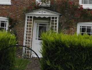
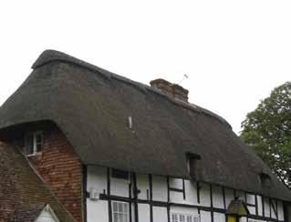
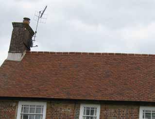
6 Architectural Matrix architectural matrix identifies some of the core elements that make up the character of the village and should be considered within future development proposals. Fenestration EXAMPLES EXISTING PRINCIPLES Brick finish and flint frontages are common across the historical character of the village. Red brick is most prevalent although in the core of the village painted brick is common. re are limited instances of timber boarding on the facades of buildings. White window frames prevail across the area with a mix of timber and PVC frames. Wooden sash and casement windows are common, whilst well proportioned PVC window are becoming more prevalent. Single bay windows are largely restricted to Victorian terrace development within the village. Porches Porches are a common feature and come in a variety of forms with flat and pitched typologies, beit wooden, tiled or with lead flashing. Historical and most recent development continue this strong variation. Boundary Treatment Medium height flint walled boundary treatment is prevalent across the village, as is green boundary edges in the form of medium height hedgerows. In the core of the village and along the historical routes, buildings often abut the back edge of the pavement, if not the edge of the carriageway. To the edge of the village post and rail fencing is also visible. Roof Forms Detailing Roof forms are generally pitched with chimney detailing. Gable fronted roofs are also common with often a mix of roofs forms are found within a street scene. Dormer and velux windows are also present within the village. Clay tiles are the most common form of roofing although modern slate like tiles are used on the most recent development within the village. Being a rural location thatched properties also exist. Brick detailing is the most common form across the village. This is generally found around window surrounds, although brick patterns are often used to contrast with the flint walls. Colour Tones Roof edge Doors/ Doors/ Doors/Gates Roof A range of colours exist across the Village, with variation in tones. Doors Doors Roof


7 Contemporary Development Whilst the core of the East Meon retains its exquisite character. expansion of the village in the postwar period and the mid 80 s has not seen the level of architectural quality associated with the village core. However, in recent years a new small development has occurred to the west of the village adjacent to the Village Hall known as Green, from which principles can be Similarities between old and new Irregular ridge line Use of local materials Mix of gable fronted and pitched roof forms Similar window proportioning using modern materials. A mix of colour and wall finishes in keeping with more historical elements of the village. learned about retaining character whilst meeting modern needs and standards. Additional principles to consider One noticeable element is that even though in some instances the same house types have been used, they each have a uniqueness about them. New modern colour tones introduced Development works well with its immediate context and open setting.

8 7 Concept Layout following sketches show two ways in which development could be brought forward. Vehicular access Vehicular access Both sketches assume a new access to the north provided by a new high quality bridge, designed with the local vernacular in mind. This is being assessed for viability at present. Existing football pitch Development frontage overlooks playing field Existing football pitch In each case a range of Drainage pond to be an ecological feature Pedestrian/cycle link only New Green Pedestrian/cycle link only housing will be sort to provide new homes for a variety of budgets and that respect the local character and its landscape setting. Focal space within street scene Pedestrian/cycle link only Pedestrian/cycle link only Loose Development Option New Green Space - with more compact development


9 8 Initial Thoughts Some initial sketches of the types of housing within the village. Preliminary Design Sketches Potential Access Point
7.1 Area 1: Haslemere Conservation Area
 7.1 Area 1: Haslemere Conservation Area Detailed map of Haslemere Town Conservation Area as of 2006 Crown copyright and database right 2011 Ordnance Survey LA100025451 27 The Conservation Area is characterised
Design Brief. Proposed housing development, White Horse Lane, Trowse FOR. Norfolk Homes
 Design Brief Proposed housing development, White Horse Lane, Trowse FOR Norfolk Homes JOB NO: 10.2812.030 DATE: September 2010 1 Site The Village of Trowse is situated approximate 2 kilometers South East
Public Consultation. Land at Monks Farm, North Grove. Welcome
 Welcome Welcome to our public exhibition for development on Land at Monks Farm, orth Grove. Gallagher Estates and Gleeson Strategic Land are preparing an outline planning application for new homes, open
The Cedars THE CAUSEWAY 8 GREAT HORKESLEY 8 COLCHESTER
 The Cedars THE CAUSEWAY 8 GREAT HORKESLEY 8 COLCHESTER The Cedars The Causeway, Great Horkesley, Colchester CLASSIC PERIOD COUNTRY HOUSE WITH SELF CONTAINED ANNEXE, SUPERB GARDENS & PADDOCKS ON THE EDGE
8.0 Design and Form of Development 43/
 42/ 8.0 Design and Form of Development 43/ Rothwells Farm, Golborne/ Development Statement Figure 7. Site Constraints Key 44/ Site Boundary 360 Bus Route/Stops Existing Trees Underground Water Pipe Sensitive
6. Design and Architectural Guidance
 6. Design and Architectural Guidance The following Design Guidelines are proposed to apply to all areas of Haslemere. They are intended to enhance and maintain the character and scale of the area. Principles
MATURE SUBURBS RESIDENTIAL DEVELOPMENT GUIDELINES
 MATURE SUBURBS RESIDENTIAL DEVELOPMENT GUIDELINES DRAFT FEBRUARY 2005 BIRMINGHAM CITY COUNCIL 1 Introduction Mature Suburbs Residential Development Guidelines - Interim Supplementary Planning Advice -
PDP DESIGN & ACCESS STATEMENT
 PDP The Planning & Design Partnership Planning.. Architecture.. Interiors.. Landscape The Chicory Barn Studio, The Old Brickyards, Moor Lane, Stamford Bridge York, The East Riding Of Yorkshire, YO41 1HU.
GREENFORD HALL & ADJOINING LAND
 GREENFORD HALL & ADJOINING LAND CONTENTS 1. Introduction 1. Introduction 2. Urban Context 2.1 The Site and Surroundings 2.2 Urban Context Map 2.3 Access and Movement 3. Planning Context 3.1 Planning History
Land at Rampton Road. Cottenham
 Land at Rampton Road Cottenham Introduction TEP is preparing an outline planning application for 54 dwellings on 6.9 hectares of land adjacent to Rampton Road, Cottenham on behalf of the owners Cambridgeshire
BROADHEMBURY DESIGN STATEMENT
 BROADHEMBURY DESIGN STATEMENT As drawn up by Broadhembury Parish Council during the development of a Parish Plan and adopted at its meeting on 17 th May 2010 BROADHEMBURY DESIGN STATEMENT Contents Introduction
Site ref: AS06 Site Name or Address: Murreys Court, Agates Lane
 Site ref: AS06 Site Name or Address: Murreys Court, Agates Lane Proposed Land Use: Total Site Area (Ha): Housing 1.85 Ha Description: It is understood that the owner has no plans to dispose of the site
Design Guidelines. High Point Estates Design Guidelines April Gomberoff Bell Lyon Architects Group Inc.
 High Point Estates April 2006 Gomberoff Bell Lyon Architects Group Inc. 1 29 Contents Part One The Building Scheme Part Two Architectural Character and Siting Building Part One: The Building Scheme i 31
PROPOSED RESIDENTIAL DEVELOPMENT LAND AT TRETHURFFE LADOCK, TRURO Design & Access Statement
 PROPOSED RESIDENTIAL DEVELOPMENT LAND AT TRETHURFFE LADOCK, TRURO Design & Access Statement Heron Way, Newham, Truro, Cornwall, TR1 2XN Tel: 08453 707 111 Fax: 08453 707 113 www.csa-architects.co.uk E:
Built Up Area Boundary (BUAB)
") Parish Boundary Built Up Area Boundary (BUAB) Potential Sites Map not to scale DWELLING SIZE POLICY Residential developments must provide a mix of dwelling sizes (market and affordable) that reflect the
Parish Boundary Built Up Area Boundary (BUAB) Potential Sites Map not to scale DWELLING SIZE POLICY Residential developments must provide a mix of dwelling sizes (market and affordable) that reflect the
Lancaster Conservation Area Appraisal. Character Area 8. Cathedral
 Lancaster Conservation Area Appraisal Character Area 8. Cathedral March 2013 118 3.8 Character Area 8. Cathedral 3.8.1. Definition of Special Interest "This character area is distinctive for the fine group
Section 6.0: Glencullen Design Guide
 Section 6.0: Glencullen Design Guide The Planning Authority requires that the adherence to each of the above principles will be demonstrated at the Planning Application stage using appropriate visualisation
Introduction. Welcome to this consultation regarding the draft redevelopment proposals for the former CeramTec factory on Sidmouth Road, Colyton.
 Introduction Welcome to this consultation regarding the draft redevelopment proposals for the former CeramTec factory on Sidmouth Road, Colyton. We are currently considering options for the mixed-use redevelopment
4 Residential and Urban Living Zones
 4 Residential and Urban Living Zones Refer to Chapters 11 to 20 for additional rules that may apply to these zones. 4.1 OBJECTIVES AND POLICIES Objective Res1 Policy 1 Policy 2 Policy 3 Policy 4 Policy
DRAFT CONSERVATION AREA APPRAISAL CHAILEY GREEN DESIGNATED
 DRAFT CONSERVATION AREA APPRAISAL CHAILEY GREEN DESIGNATED 16.06.76 DRAFT CHAILEY GREEN CONSERVATION AREA APPRAISAL 1 SUMMARY 1.1 Key Positive Characteristics 1.2 Recommendations 2 INTRODUCTION 2.1 The
East Dulwich East Dulwich Area Vision Map
 Area Vision Map Denmark Hill Station Peckham Rye Station Nunhead Station Peckham Rye NSP38 Station NSP37 Goose Green NSP39 North Dulwich Station Key: Dulwich Village NSP40 St Barnabas Church Court Lane
30. Riverstown Mini-Plan
 County Development Plan 2017-2023 Consolidated Draft + Adopted Amendments August 2017 Volume 2, Chapter 30 Riverstown Mini-Plan 30. Riverstown Mini-Plan Village profile Riverstown is located approximately
6. Ballintogher Mini-Plan
 County Development Plan 2017-2023 Consolidated Draft + Adopted Amendments August 2017 Volume 2, Chapter 6 Ballintogher Mini-Plan 6. Ballintogher Mini-Plan Village profile Ballintogher is located approximately
Land to West of Bessel s Way, Blewbury. Contextual Analysis. fluid
 Land to West of Bessel s Way, Blewbury Contextual Analysis fluid Contents fluid - Overview - Growth pattern - Footpath & Road connections - Landscape Character - Amenities - Agriculture - Characteristic
17. Coolaney-Rockfield Mini-Plan
 County Development Plan 2017-2023 Consolidated Draft + Adopted Amendments - August 2017 17. Coolaney-Rockfield Mini-Plan Village profile Coolaney is located approximately 23 km to the south-west of Sligo
1 THE OLD VICARAGE MANOR ROAD F GORING ON THAMES F OXFORDSHIRE
 1 THE OLD VICARAGE MANOR ROAD F GORING ON THAMES F OXFORDSHIRE 1 THE OLD VICARAGE MANOR ROAD F GORING ON THAMES F OXFORDSHIRE Pangbourne on Thames 5 miles F Reading 10 miles F Newbury 13 miles F Oxford
1. Local Plan Context
 1. Local Plan Context WHY ARE YOU HERE? ABOUT US PLANNING APPLICATION CONSULTATION Stewart Milne Homes are in the process of preparing a detailed planning application for a development of approximately
Newcourt Masterplan. November Exeter Local Development Framework
 Newcourt Masterplan November 2010 Exeter Local Development Framework Background The Exeter Core Strategy Proposed Submission sets out the vision, objectives and strategy for the development of Exeter up
STRENSALL RAILWAY BUILDINGS CONSERVATION AREA APPRAISAL. In association with Strensall with Towthorpe Parish Council
 STRENSALL RAILWAY BUILDINGS CONSERVATION AREA APPRAISAL In association with Strensall with Towthorpe Parish Council CONTENTS Page 1 Introduction 2 2 Location and Context 3 3 Topography and Setting 4 4
WELCOME GYPSY LANE. Wider Site Location plan. Proposals for the development of LAND OFF FOXLYDIATE LANE WEBHEATH. Proposals for the development of
 WELCOME The developers are preparing an outline planning application for a residential led development and need the community s views in order to develop the proposals further WHAT IS PROPOSED? A high
WELCOME. Land North of STEVENAGE. We would like to thank you for attending our public exhibition today.
 WELCOME We would like to thank you for attending our public exhibition today. The purpose of this event is to share our proposals and hear your thoughts on our ideas. Members of the project team are on
vision & process willowburn, tarves community engagement 04/18
 vision & process Historic Conservation area Scotia intend to create a high quality residential development based upon best practice urban design principles. This will include a contemporary reinterpretation
Lincoln Townscape Assessment. Boultham Park Inherited Character Area Statement
 Lincoln Townscape Assessment Boultham Park Inherited Character Area Statement January 2008 Page 2 of 12 Table of Contents Page Overview 2 Historical Development 2 Urban form 3 Views 5 Condition of Buildings
Warren Farm, Ampthill
 1 Welcome The developers of the Warren Farm site, Bloor Homes and Connolly Homes, are holding this exhibition on the emerging Design Codes for the development prior to their formal submission to Central
Statement of Community Involvement LAND OFF SOUTHDOWN ROAD HORNDEAN, HAMPSHIRE
 LAND OFF SOUTHDOWN ROAD HORNDEAN, HAMPSHIRE CONTENTS Page 1. Introduction 3 2. Pre-application Discussions 4 3. The Consultation Process 5 4. Consultation Feedback 7 5. Responses to Consultation Feedback
Morgan s Subdivision Historic District Character-defining Features
 Morgan s Subdivision Historic District Character-defining Features DISTRICT DESCRIPTION This small addition, designed as a neighborhood for those wishing to move east from Capitol Hill, was predominantly
Sunday's Well Proposed Architectural Conservation Area
 1 Sunday's Well Proposed Architectural Conservation Area D A E C B F Old City Gaol Saint Vincent s RC Church Saint Albert s Former Good Shepherd Convent Boundary of Area Sunday's Well is an area located
INTRODUCTION. Land West of Main Road, Stanton Harcourt THE SITE. Why is the Site Suitable for Development?
 0 INTRODUCTION THE SITE Application Boundary Gladman Developments Ltd has successfully invested in communities throughout the UK over the past 0 years, developing high quality and sustainable residential,
SANDPIT FARM BRUISYARD 8 SUFFOLK
 SANDPIT FARM BRUISYARD 8 SUFFOLK SANDPIT FARM Bruisyard, Suffolk GRADE II LISTED COUNTRY HOUSE OFF A QUIET COUNTRY LANE SURROUNDED BY UNDULATING COUNTRYSIDE WITH ATTRACTIVE GARDENS, STUDIO ANNEXE, TRADITIONAL
Welcome to our exhibition
 Welcome to our exhibition The Homes & Communities Agency (HCA) welcomes you to this public exhibition explaining our proposals for the redevelopment of the former Lea Castle Hospital site. About the Homes
20. Ballysadare Mini-Plan
 20. Ballysadare Mini-Plan 20. Ballysadare Mini-Plan Community facilities Ballysadare has a wide range of community facilities: a primary school, St Mary s College (secondary school), a health centre, playing
DESIGN & ACCESS STATEMENT
 . DESIGN & ACCESS STATEMENT Site Adjacent to The Manor House, Upper Street,, Kingsdown, Deal, Kent. DESIGNS ARCHITECTURE + PLANNING CONTENTS Design and Access Statement Introduction Site and Location Planning
LAUREL HOUSE. Holme Marsh HR5 3JS
 LAUREL HOUSE Holme Marsh HR5 3JS Laurel House Holme Marsh Herefordshire HR5 3JS A unique, energy efficient architect designed four-bedroom house, forming part of this small rural hamlet in north west Herefordshire.
E. RURAL COMMERCIAL/INDUSTRIAL PARK MODEL
 E. RURAL COMMERCIAL/INDUSTRIAL PARK MODEL 1. PURPOSE The purpose of the Rural Commerce/Industrial Park Model is to provide parameters within which a grouping of business buildings with parking, loading
HURSTPIERPOINT SAYERS COMMON PARISH COUNCIL
 HURSTPIERPOINT SAYERS COMMON PARISH OFFICE TRINITY ROAD HURSTPIERPOINT HASSOCKS WEST SUSSEX BN6 9UY TEL: 01273 833264 FAX: 01273 834976 E-MAIL: HURSTPIERPOINT.PC@BTINTERNET.COM WEB SITE: WWW.HURSTPIERPOINT-PC.ORG.UK
THE OLD House FRENSHAM SURREY
 THE OLD House FRENSHAM SURREY THE OLD HOUSE FRENSHAM SURREY A beautifully presented Grade II listed country house with stunning gardens, situated on the edge of a highly sought after village and with
National Character Area 70 Melbourne Parklands
 Summary The are a landscape of rolling farmland, parkland and woodland on the northern flanks of the ridge between Burton upon Trent and Swadlincote. The land slopes down to the River Trent, which borders
Chapter IV: Development Pattern
 Chapter IV: Development Pattern Introduction The 2002 Prince George s County Approved General Plan designates three growth policy tiers Developed, Developing, and Rural as well as three center designations
1. Objectives of this consultation
 1. Objectives of this consultation Provide an update on the results of the December 2014 consultation Provide a summary of the Pre-Submission Plan which is now out for formal consultation To ask for your
WINDSOR GLEN DESIGN GUIDELINES
 WINDSOR GLEN DESIGN GUIDELINES Adopted by Council, 2006 WINDSOR GLEN REDEVELOPMENT DESIGN GUIDELINES August 2006 1.0 Master Plan Organization For this area of the Coquitlam Town Centre, a mix of high,
97 Lea Bridge Road, Leyton, E10 7QL London Borough of Waltham Forest December 2015
 97 Lea Bridge Road, Leyton, E10 7QL London Borough of Waltham Forest December 2015 Public Realm and Landscape Proposals LEA BRIDGE ROAD, WALTHAMSTOW Public Realm & Landscape Proposals BDP(90)RPT001 December
9 Pershore. Introduction. Pershore Abbey
 118 Introduction 9.1 The historic town of Pershore lies on the River Avon and has a population of 7,000 (2009 Mid-Term Population Estimates). The main areas of the town are centred on the Abbey, the bustling
WELCOME TO THE NEW WILTON PARK
 WELCOME TO THE NEW WILTON PARK VISION HISTORY OF WILTON PARK TOWARDS A PLANNING APPLICATION Our objective is to create a truly outstanding environment at Wilton Park. At the heart of our proposals is a
Highfield House. Wilton, Wiltshire
 Highfield House Wilton, Wiltshire Highfield House Wilton, Wiltshire A magnificent renovated Country House in about 5.4 acres of private grounds. Marlborough 8 miles, Great Bedwyn 2.6 miles with mainline
MEDLANDS FARM Combe Lane, Shere, Guildford, Surrey
 MEDLANDS FARM Combe Lane, Shere, Guildford, Surrey MEDLANDS FARM Combe Lane, Shere Guildford, Surrey GU5 9TD SHERE VILLAGE - 0.75 mile Guildford (Waterloo 38 mins) - 5 miles Set in 37 acres of pastureland
Former Panshanger Aerodrome, Welwyn Garden City Masterplan Scenarios. Mariposa Investments
 Former Panshanger Aerodrome, Welwyn Garden City Masterplan Scenarios Mariposa Investments Contents 1.0 Introduction 1 2.0 The Site and Surroundings 2 3.0 Local Area Context 6 4.0 Site Features 10 5.0 Development
LITTLE ASHLEY FARM ASHLEY GREEN WILTSHIRE
 LITTLE ASHLEY FARM ASHLEY GREEN WILTSHIRE LITTLE ASHLEY FARM ASHLEY GREEN LITTLE ASHLEY BRADFORD-ON-AVON WILTSHIRE BA15 2PW An exquisite and picturesque country house with an excellent range of stone built
ABOUT CALA HOMES CALA HOMES
 WELCOME Welcome to this public consultation event for our proposed development on land to the east of Salisbury Road, in Hungerford. Thank you for taking the time to come along today. Homes and Wates Developments
Environmental and Landscape Mapping
 Environmental and Landscape Mapping In support of the Calveley Neighbourhood Plan November 2016 Project Name and Number: Calveley Neighbourhood Plan 16-025 Document Name and Revision: Environmental and
Land Adj. 63 Sunny Bank Road, Sutton Coldfield, Birmingham, B73 5RJ
 Committee Date: 11/07/2013 Application Number: 2013/03520/PA Accepted: 20/05/2013 Application Type: Full Planning Target Date: 15/07/2013 Ward: Sutton Vesey Land Adj. 63 Sunny Bank Road, Sutton Coldfield,
B L A C K D I A M O N D D E S I G N G U I D E L I N E S for Multi-family Development
 B L A C K D I A M O N D D E S I G N G U I D E L I N E S for Multi-family Development Adopted June 18, 2009 This section of the Design and focuses on site planning and design guidance for new multi-family
PROPOSED RESIDENTIAL DEVELOPMENT LAND AT GREEN LANE, YARM
 PROPOSED RESIDENTIAL DEVELOPMENT LAND AT GREEN LANE, YARM PUBLIC CONSULTATION YOUR VIEW MATTERS TO US LOCATION PLAN Thank you for taking the time to read this information leaflet regarding a proposed residential
1.0 INTRODUCTION. Brantham Industrial Area Regeneration - Factory Lane - Brantham
 1.0 INTRODUCTION Welcome to this exhibition of our proposals for the regeneration of the Brantham Industrial Area located off Factory Lane in Brantham. This presentation will give you an opportunity to
ST DONATS. Eaton Bishop HR2 9QG
 ST DONATS Eaton Bishop HR2 9QG St Donats Cottage Eaton Bishop Herefordshire HR2 9QG In a beautiful rural setting and enjoying far reaching southerly views across rolling countryside, a well-appointed and
Story Homes. Land at Thirsk Road, Kirklevington. An Introduction to Story Homes. Our Foundations. Commitment to Consultation.
 Story Homes An Introduction to Story Homes Founded by Fred Story in 1987, Story Homes has a long and successful reputation of building high quality and high specification homes. The family owned business
Chapter 2: OUTLINE PLANNING APPLICATION PROPOSALS. A New Garden Neighbourhood Matford Barton 17
 Chapter 2: OUTLINE PLANNING APPLICATION PROPOSALS A New Garden Neighbourhood Matford Barton 17 2.1. SUMMARY AND STATUS OF THE PROPOSALS 2.1.1. The parameter plans and associated wording in this chapter
PROPOSED RESIDENTIAL DEVELOPMENT MAWNAN SMITH CORNWALL Design & Access Statement
 PROPOSED RESIDENTIAL DEVELOPMENT MAWNAN SMITH CORNWALL Design & Access Statement St Piran House, Heron Way, Newham, Truro, Cornwall, TR1 2XN Tel: 08453 707 111 Fax: 08453 707 113 www.csa-architects.co.uk
East Harptree Landscape & Character Assessment
 East Harptree Landscape & Character Assessment Produced by East Harptree Parish Council in consultation with local residents September 2014 Contents The Parish of East Harptree: Objective Introduction
WELCOME. Olney Road, Lavendon INTRODUCTION. The Site. The Application. The Need for Housing. A Sustainable Location LAVENDON TURVEY OLNEY ROAD
 0 WELCOME INTRODUCTION Gladman Developments Ltd have successfully invested in communities throughout the UK over the past 0 years, developing high quality and sustainable residential, commercial and industrial
INTRODUCTION. Land south of Bishopswood Lane, Tadley
 0 INTRODUCTION THE SITE Introduction Gladman Developments Ltd. has successfully invested in communities throughout the UK over the past 0 years, developing high quality and sustainable residential, commercial
Land off Arbour Close and Cotswold Edge Mickleton, Gloucestershire. Design and Access Statement Mickleton, Gloucestershire
 Land off Arbour Close and Cotswold Edge Contents INTRODUCTION Vision SITE DESCRIPTION The site Technical Assessment ASSESSMENT & EVALUATION Constraints and opportunities SITE CONTEXT Pattern of Development
You only need to complete the sections that are relevant to the character area. Any other comments can be completed on a separate sheet.
 Wisborough Green Village Design Statement Character Area B Estates and Wyatt House. Killingbeck comments in blue Survey Sheet Date: 2 nd December 2012 J & RM, S&PK You only need to complete the sections
Keystone Business Park Precinct Structure Plan North East Industrial Precinct. Part 2 Design Principles
 Keystone Business Park Precinct Structure Plan North East Industrial Precinct Part 2 Design Principles Context Issues Services Landform Issues Geotech and contamination Ecology Traffic and access Issues
WATLINGTON DESIGN GUIDE 2017 WNDP 11
 WATLINGTON DESIGN GUIDE 2017 WNDP 11 1 Foreword: This Design Guide has been prepared as part of Watlington s Neighbourhood Development Plan with the aim of securing the highest quality new development
STATEMENT OF OBJECTION TO THE PROPOSED DEVELOPMENT OF LAND AT CHURCH CLIFF DRIVE FILEY
 STATEMENT OF OBJECTION TO THE PROPOSED DEVELOPMENT OF LAND AT CHURCH CLIFF DRIVE FILEY You will be aware that Scarborough borough council have adopted a new local plan that includes land at Church Cliff
Land East of Cromwell Lane
 Land East of Cromwell Lane VISION DOCUMENT AUGUST 2016 The proposals for Land East of Cromwell Lane will be defined by existing landscape features, ensuring that the development offers a quality place
16. Collooney Mini-Plan
 16. Collooney Mini-Plan Village profile Collooney is located approximately 13 km to the south of Sligo City, in a designated Rural Area under Urban Influence. The village provides a range of services for
Public Consultation 23 January Peel Hall, Warrington Board 1. A message from Satnam... Site history...
 Board 1 A message from Satnam... Thank you for attending today s public consultation about proposals to develop a new residential neighbourhood at. The display boards show why the development is needed
ENVIRONMENTAL AND LANDSCAPE MAPPING
 APPENDIX IV : Environmental and Landscape Mapping ENVIRONMENTAL AND LANDSCAPE MAPPING Calveley Neighbourhood Plan November 2016 ENVIRONMENTAL AND LANDSCAPE MAPPING Calveley Neighbourhood Plan Calveley
Settlement Boundaries Methodology North Northumberland Coast Neighbourhood Plan (August 2016)
") Introduction This background paper sets out a methodology for the definition of settlement boundaries in the North Northumberland Coast Neighbourhood Plan. The neighbourhood plan is planning positively
Introduction This background paper sets out a methodology for the definition of settlement boundaries in the North Northumberland Coast Neighbourhood Plan. The neighbourhood plan is planning positively
Appendix 4 - Character Assessment and Design Code. Character Assessment
 Appendix 4 - Character Assessment and Design Code Character Assessment To gain a deeper understanding of the Parish for the Neighbourhood Plan, a Character Assessment of the parish was carried out with
Page 1 of 19 URBAN DESIGN FRAMEWORK FOR BOLTON STREET WATERFORD
 Page 1 of 19 URBAN DESIGN FRAMEWORK FOR BOLTON STREET WATERFORD 1.0 Introduction: The relocation of the City Council stores and depot from Bolton Street creates an exciting opportunity for development
U p p e r L a n g d a l e s F a r m h o u s e C R E E T I N G S T M A R Y 8 S U F F O L K
 U p p e r L a n g d a l e s F a r m h o u s e C R E E T I N G S T M A R Y 8 S U F F O L K Upper Langdales Farmhouse Creeting St Mary, Suffolk, IP6 8QF R E S T O R E D P E R I O D F A R M H O U S E I N
Urban Design Brief to 1557 Gordon Street & 34 Lowes Road West
 Urban Design Brief 1533 to 1557 Gordon Street & 34 Lowes Road West Reid s Heritage Homes Ltd. & 883928 Ontario Ltd. and RHH Property Management Ltd. City of Guelph Zoning By-law Amendment November 2017
PROPOSED REDEVELOPMENT OF THE GLEN ABBEY GOLF CLUB. STREETSCAPE DESIGN STUDY (excerpt from the Urban Design Brief) TOWN OF OAKVILLE.
 TOWN OF OAKVILLE.") PROPOSED REDEVELOPMENT OF THE GLEN ABBEY GOLF CLUB STREETSCAPE DESIGN STUDY (excerpt from the Urban Design Brief) TOWN OF OAKVILLE OCTOBER, 2016 for 2.4.2 STREETS Streets are the single largest component
PROPOSED REDEVELOPMENT OF THE GLEN ABBEY GOLF CLUB STREETSCAPE DESIGN STUDY (excerpt from the Urban Design Brief) TOWN OF OAKVILLE OCTOBER, 2016 for 2.4.2 STREETS Streets are the single largest component
New Homes at Winton East
 View toward Winton East from Caerketton Hill Aerial photograph of South Edinburgh: Winton East Site Location Indicative proposal Welcome Thank you for coming to the Winton East public exhibition. We would
Neighbourhood Planning Site Assessment Pro-forma and Guide Version 2
 Neighbourhood Planning Site Assessment Pro-forma and Guide Version 2 September 2014 Site HNP 006 Land East of Stanbridge Road and North of Lower Road 1. Background information Site location and use Site
Aire Valley Leeds Area Action Plan - Marsh Lane Allocation (AV18)
") City Development Policy and Plans Group The Leonardo Building 2 Rossington Street LDS LS2 HD 3 th January 207 Our ref: TP/LN/207-006 Network Rail Floor 3A/55 George Stephenson House Toft Green York YO
City Development Policy and Plans Group The Leonardo Building 2 Rossington Street LDS LS2 HD 3 th January 207 Our ref: TP/LN/207-006 Network Rail Floor 3A/55 George Stephenson House Toft Green York YO
Appraisal of proposed alterations to the boundary of Helmsley Conservation Area
 Appraisal of proposed alterations to the boundary of Helmsley Conservation Area Elmslac Road: Elmslac Road was constructed in the early 1950s in two or three stages by the Helmsley Rural District Council.
Status of Supplementary Planning Guidance OLD WOKING CONSERVATION AREA Character Appraisal and design Guidance
 Status of Supplementary Planning Guidance OLD WOKING CONSERVATION AREA Character Appraisal and design Guidance Status This Planning Guidance which is supplementary to Policy BE9 of the Woking Borough Local
What do you like about South Marston?
 What do you like about South Marston? What you have said so far: Strong and separate identity, distinct from Swindon Village character (Church, School, Green and Hall) Surrounding working countryside and
Yorkshire Dales National Park Authority
 Yard 1 2 Plane Tree The Reading Room Yorkshire Dales National Park Authority Application Code: Committee Date: 08/12/2015 Location: Prospect, Und FW Blea Head Path Track Track Bridge Path Und New Cowside
Welcome. Land adjacent Sandy Lane WALTHAM CHASE THE PROPOSED SITE
 Land adjacent Sandy Lane WALTHAM CHASE Existing Linden Homes developments Welcome Welcome to Linden Homes Southern s ( Linden ) public exhibition about its proposals for a range of high-quality homes for
26 Park West Exploring Abergavenny
 26 Park West Exploring Abergavenny Cover: Park Avenue 2 park west EXPLORING ABERGAVENNY For several years the Abergavenny and District Civic Society has been studying the streets, spaces and buildings
St Barnabas C of E Primary School, Spring Lane, Erdington, Birmingham, B24 9BY
 Committee Date: 12/06/2014 Application Number: 2014/02967/PA Accepted: 29/04/2014 Application Type: Full Planning Target Date: 24/06/2014 Ward: Erdington St Barnabas C of E Primary School, Spring Lane,
BLACKHEATH SQUASH CLUB Blackheath Sports Club, Rectory Field, Charlton Road, London, SE7 7EY. Planning, Design and Access Statement
 Planning, Design and Access Statement Revised: 28 th Jan 2016 Peter Pendleton & Associates Ltd Introduction Planning permission will be sought for a refurbishment of existing courts and extension to provide
Artists impression of the Park Promenade and plot H4 with café and restaurant uses that is still subject to change
 The Park Promenade Artists impression of how a café might look Artists impression of the Park Promenade and plot H4 with café and restaurant uses that is still subject to change Precedent images for balconies
Welcome to this exhibition which shows emerging ideas for land owned by University of Bristol at Long Ashton.
 1 Introduction Welcome to this exhibition which shows emerging ideas for land owned by University of Bristol at Long Ashton. The University of Bristol owns a 170 acre site south of Long Ashton village
Moat Farm House Hasketon I Woodbridge I Suffolk
 Moat Farm House Hasketon I Woodbridge I Suffolk Moat Farm House Hasketon Woodbridge Suffolk IP13 6JW Woodbridge 4 miles, Ipswich 9 miles (London Liverpool Street about 65 minutes) An exquisite Grade II
Parish Derry Slopes ITM Coordinates ; NG Coordinates C House B1 and farm buildings B2; Registered Garden L061
 Asset Ref No. HB/01/27/018A-C, Ballyarnett & Farm; Registered Historic Garden L061 Heritage Type Location Protection Status Condition Ownership (if known) Built Post-Medieval house & farm OS 6-inch map