Landscape Appraisal at Cattishall, Bury St Edmunds
|
|
|
- Madison James
- 5 years ago
- Views:
Transcription
 B.L.A. M.L.I. VANESSA HILL B.A. (HONS) M.")
1 Great Barton Parish Council Landscape Appraisal at Cattishall, Bury St Edmunds Strategic landscape proposals to protect settlement identity March 2012 LSDP Chartered Landscape Architects OCTAGON HOUSE THE WATER RUN HITCHAM IPSWICH SUFFOLK IP7 7LN T: E: PARTNERS: GILES HILL B.A. (HONS) B.L.A. M.L.I. VANESSA HILL B.A. (HONS) M.A.
2 CONTENTS: Part 1 Text 1. Introduction 3 2. Description of site 4 3. History of Cattishall 5 4. Landscape Character 6 5. Visual effects Views 7 6. Conclusions and recommendations 8 7. Landscape strategy 9 Part 2 Figures Figure 1: Site location 12 Figure 2: Aerial view 13 Figure 3: Strategic Growth areas 14 Figure 4: Map Figure 5: Map Figure 6: Map late 1880s 17 Figure 7: Suffolk LCA landscape types 18 Figure 8: Local character areas 19 Figure 9: Photos from Green Lane 20 Figure 10: Strategic landscape masterplan 21 Front cover photo: Cattishall c.1980, timber barn, now demolished. LSDP Chartered Landscape Architects OCTAGON HOUSE THE WATER RUN HITCHAM IPSWICH SUFFOLK IP7 7LN T: E: LSDP@btinternet.com PARTNERS: GILES HILL B.A. (HONS) B.L.A. M.L.I. VANESSA HILL B.A. (HONS) M.A.
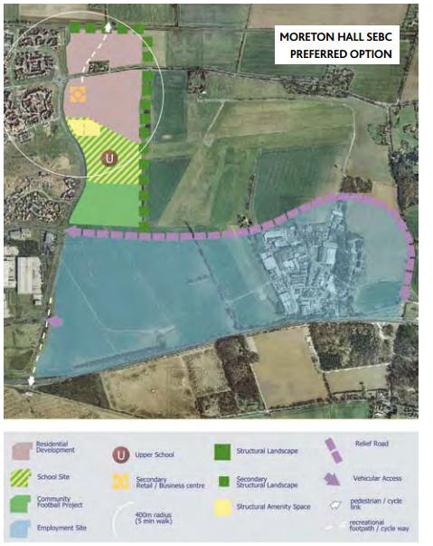
3 1. Introduction The intentions of this report This report has been prepared for the residents of Cattishall, a small hamlet in the parish of Great Barton, to the north-east of Bury St. Edmunds, in relation to the proposed strategic growth areas adjacent to Moreton Hall. The arable land to the west of the hamlet has been designated for 1250 new dwellings and other associated uses. To the south, expansion of Moreton Hall further east is also proposed which will assimilate the southern end of the lane, beyond the old level crossing, on which the hamlet sits. The residents wish to conserve the character of their hamlet, screen the new development and ensure important local landscape features are retained. It is hoped the land owners, the developers and St. Edmundsbury BC will give this submission due consideration. St. Edmundsbury BC launched a consultation exercise in March 2012 through the publication of their Vision In the Preferred Options document relating to strategic growth (p75) questions 47 and 45 relate to these land parcels (see Figure 3 Strategic growth areas). They invite consultees to respond to the proposed development boundaries. This study is timely to allow the residents to respond to consultation and it will help inform the residents response. Method of approach This study takes a historic landscape approach to evaluate the landscape for its key characteristics and to identify any features of value that should be retained and integrated in any future masterplan. It also uses Landscape and Visual Impact Assessment methods to identify who will experience the effects of the new development and the nature of the change. In addition to observations from a site visit the study draws on the following sources: - landscape character assessment by Suffolk County Council - Historic landscape character mapping by Suffolk County Council - St. Edmundsbury planning policies - maps and references from archives - aerial photographs The report concludes with a landscape strategy and sketch concept to suggest a form to the interface between Cattishall and the new developments to both the west and south, and a set of recommendations which aim to influence the site masterplans. These will minimise detrimental effects on the wider landscape and benefit not only to the residents of the hamlet, but to all those who enjoy the amenity it offers. Planning background Two of the five strategic growth areas proposed in the Core Strategy, adopted in 2010, will affect Cattishall. (See Figure 3: Strategic growth areas.) The areas of proposed expansion known as North-east Bury St Edmunds and Moreton Hall. The former is earmarked to deliver 1250 homes and other land uses and comprises 3 arable fields to the west and north-west of Cattishall. It comprises the land east of the A143, from where access will be provided, to the green lane on which Cattishall in located. 3
 This will be developed into a masterplan during the course of 2012 with wide grassy verges, well managed hedges to either side and mature trees within.")
4 Within the parcel the developers, Berkeley homes, have proposed their preferred concept for the layout of the development. (See fig 3 Strategic Growth areas) This will be developed into a masterplan during the course of 2012 with wide grassy verges, well managed hedges to either side and mature trees within. The westerly, unsurfaced part is used for farm access and by walkers for whom it is a valued local route. Across the railway line to the south the proposed eastward expansion of Moreton Hall will mean a change from the current arable land use to 500 houses and a secondary school. The hamlet will, therefore, eventually be bounded on two sides by new development. 2. Description of site Cattishall comprises an old farmhouse and 4 cottages that date from the 20 th century. Old maps show earlier cottages here that would have been associated with the farmstead. A large timber barn complex also existed until the early 1980s which is currently under pheasant cover. Across the railway line are two further cottages on the far end of the lane where it meets Mount Road, and the Flying Fortress pub is located south of these. The original pub building was previously the farm manager s cottage so was strongly associated with the farmstead. The dwellings sit either side of a spur of the isolated Green Lane, severed when the level crossing was closed in the 1970s. The ancient Green Lane links the Thurston road to the east, past Gt. Barton church, and across farmland to the Bury/Gt. Barton road to the west (A143) at Anglenook Cottages. It continues beyond as Coltons Ride which bounds the Barton Stud. The lane is surfaced only as far as the route into Cattishall and is an attractive feature View along Green Lane A linear T-shaped track is shown on historic and current OS maps which connects Cattishall farm with Green Lane and land due south. This partly aligns to an old field boundary (see figure 6) and the underpass beneath the railway. It is not marked as a footpath on the current OS maps. In terms of topography, the land to the east and north is on the plateau and is relatively level, between 55 and 60m AOD, but to the west land begins to fall gently away towards the River Lark. 4
5 3. History of Cattishall The ancient meeting place of the court of the Abbott of Bury St Edmunds was at Cattishall. The Saxons held a local parliament here (the Hundred Moot) which continued after the Normal invasion as a court of the King s justices. In 1305 the location of this Shirehall was moved to Henhow, to the NW of Bury. An artificial tumulus would have marked the location of the moot of the local hundred, the administrative unit of the day. It is probably this moot mound, no longer present, that gave rise to the original name Cateshill. The tumulus is no longer present or mentioned on current OS maps although its site is noted on OS maps of However, the Cattishall moot is much older than the existing medieval records indicate as it was probably Roman in origin. The tumulus was excavated in 1957 and was found to contain Romano-British as well as medieval pottery. On earlier OS maps a collection of buildings is seen here. On the 1904 OS map the barn is named Tyburn Barn. Tyburn is a word synonymous with execution as Tyburn was the part of west London where hangings took place. Together with the association of a place of justice, Cattishall may therefore also have had its own gallows. The sequence of historic maps provides a good picture of how the character of the current landscape, which is relatively recent in appearance, came about. The land around the farmstead was historically heathland. On maps from the 1700 s a narrow strip of land can be seen around which the buildings were organised which was a protrusion of Blowthorn Heath to the south. There was Upper Green and Lower Green in 1741, in 1783 it is named Catshall Green. (see Figures 4 and 5) Perhaps this is why the lane is named Green Lane as it led to the Green, rather than because of its grassy appearance Agriculture in this part of Suffolk was generally on common arable fields, with areas of grazed heathland in between, up until the 18 th and 19 th centuries when the land was enclosed by Acts of Parliament. Such enclosure was relatively late and resulted in larger open fields than is associated with earlier enclosure. As a consequence field patterns tend to be regular and linear and, as a consequence, surrounding roads and hedges also tend to be straight. In this area it is also known that there were large of areas of heathland, across which straight, direct routes would also have been standard. There is marked change in field pattern from an 1805 map to the c.1887 map (Figure 6) when irregular small field shapes and strips 5
6 have evolved into regular, rectilinear forms. This might be due to Parliamentary enclosure, although records show that land in this area was under the ownership of the wealthy Bunbury family from 1746 to the early 20 th century, and other wealthy families prior to this. The smaller square fields west of the farmhouse seen on 1958 maps were amalgamated by 1971 into the large field seen today. Around the farmhouse there are remnant landscape features. There is a line of poplars, which appears to follow an old east-west field boundary, and 3 walnut trees adjacent to the mixed copse behind the farmhouse, These features mean the scale of the landscape is finer grained here than to the west which is much more open and featureless. 4. Landscape character The landscape around Cattishall is a relatively recent manifestation but it clearly also contains ancient features within it. The area demonstrates close fit with the prevailing landscape character typology developed by Suffolk County Council in its LCA (Landscape Character Assessment www. suffolklandscape.org.uk. See Figure 7). It places Cattishall in its Plateau Estate Farmlands landscape type. There are a series of landscapes of this type in the area, along the A14 from Gazeley in the west to Thurston in the east as well as a stretch to Sapiston in the north. It s an area where the transition from the distinctive Breckland character changes into that of the Suffolk claylands to the east. This type is characterised by: - Flat landscape of light loams and sandy soils - Large scale rectilinear field pattern explained by late, parliamentary enclosure - Network of tree belts and coverts. Woodland cover is scattered but can be found in greater density around Rougham. - Large areas of enclosed former heathland - 18th- 19th & 20th century landscape parks (as seen in nearby in Gt. Barton and Rougham. Barton Hall burnt down c.1914 and its park has been redeveloped for housing, Rougham Hall was bombed in WWII and left as a ruin surrounded by conifer plantations) - Clustered villages with a scattering of farmsteads around them - Former airfields (Rougham) - Vernacular architecture is often 19th century estate type of brick and tile. Another feature of this landscape type is the pressure it is under from settlement expansion. The LCA concedes that the simple, regular and open structure of this landscape type gives it higher capacity for absorbing settlement expansion, however, it warns: It is important to integrate the settlement into the surrounding rural and sparsely settled countryside to minimise the impact on the character of the wider countryside It also states the prevailing settlement pattern has a: strong tendency towards clustered villages surrounded by a scattering or rural farmsteads. Where ever possible this clear distinction should be maintained. These two statements give a clear indication that hamlets such as Cattishall are important contributors to local character and should not be assimilated by encroaching development. 6
7 The LCA also provides guidance on land management and recommends that this character type is well served by attempts to restore and enhance tree belts, plantations, historic parklands and their elements. St Edmundsbury BC also gives relevant direction in its planning policy regarding the interface between rural areas and development. In the Natural Environment Chapter in Protection of the Landscape the Local Plan notes (para ): There is considerable scope for improving the landscape around built up areas and the adjoining countryside. It is important to reduce the visual intrusion of development and to protect and enhance the landscape features of the area. Local character On a more local level the area around Cattishall can be sub divided into 4 local areas where distinctions in character can be detected. (See Figure 8 Local character areas) Character Area 3 : Character Area 4 : Open rolling land An uncharacteristically large open field for the area. Little screening from tree cover and in combination with falling contours, views toward Bury and Moreton Hall define the skyline and bring sense of urban influence. Enclosed, estate fields Repetitive linear arable fields with enclosure through well managed hedges creates farm estate feel. Slightly more wooded feel north of Green Lane where in field copses and belts of woodland form skyline. Here the well managed hedges have more trees within them. There are fewer trees to the south/east of Green lane but the hedges still provide strong sense of enclosure and order. Character Area 1 : Character Area 2 : Farmstead and Green Lane Straight lane with wide grass verges and well managed hedges. Houses of hamlet are not readily apparent and are well concealed behind vegetation. Hedges provide enclosure and conceal views to wider landscape/urban area. Landscape features are generally in good condition. South of railway Sense of interrupted landscape, with railway, strong visual presence of new houses and infrastructure of Moreton Hall Hedges removed, only remnants remain. 5. Visual effects - Views The front of the farmhouse faces east and to the rear of the house and gardens is a dense copse and line of poplars. The arrangement of the grounds and boundary hedges to the south also make views in this direction very limited. This arrangement means the views to the new development, from the farmhouse, will be effectively screened. The four cottages to the north, on the other hand, face west and currently experience long views to the sugar beet factory on the horizon. These four cottages will, therefore, experience views over the new development at close range albeit through the partial screening offered by the intervening farm hedge and garden vegetation. Additional screening would therefore be beneficial on 7
8 the development boundary here, in a form that would be in keeping with local character. 6. Conclusions and recommendations To summarise, Cattishall has local value as an isolated hamlet for the following reasons: - it is a contributor to locally characteristic settlement pattern - it is sited on an historic Green - it had an important role in relation to the ancient Abbey settlement at Bury - the Green lane is an important landscape and biodiversity feature, uncommon and distinctive, and should be conserved as far as possible, in its current form. Therefore, it is proposed to respond to the Vision consultation with the following points: 1) To retain hedges on Green Lane within a green framework of pedestrian and cycle routes, and a wider network of rectilinear greenspaces. This will help conserve the character of Cattishall. Their future management must be properly addressed through the planning process. 2) North of the farmhouse the eastern development boundary of the B.S.E.NE parcel should be redrawn some 100m further west. This will allow the planting of a continuous linear woodland belt as shown in Figure. 9 to reduce the visual effects of the new development on the residents of the cottages. This form would be in keeping with the linear arrangement of the fields and preserve the isolation of the hamlet. A landscape belt here would conserve the site of the tumulus and the Tyburn Barn. If public access was permitted, interpretation could be provided here in relation to the importance of the site in Medieval times. A belt of vegetation on the edge of the plateau would also have the added effect of softening and breaking up the skyline from views from the west of otherwise hard, angular rooflines. 3) Immediately south of the farmhouse the incursion of the development could come further east towards the lane, as the visual impact here would be low, although a belt of boundary vegetation would still be recommended to screen the houses from the wider landscape. 4) South of the railway line the landscape is of lesser value. (see photos in figure 9) After the building of the railway this southern end of the lane was severed and the character degenerated and is now strongly influenced by the adjacent residential area of Moreton Hall. However, it was once part of the historic Green and the view southward along it would be conserved if it could be retained as a greenway route for pedestrians/cycles. Restoration of the hedges here (only remnants remain) would contribute to St Edmundsbury s policy for the protection and enhancement of landscape features in countryside adjoining built up areas. 5) The green lane represents the most significant landscape feature of value and should be left intact along its length to retain its special character. Ideally, severing it with roads should be avoided by creating two separate development parcels unlinked by roads, with only pedestrian/cycle provided between the two. The future management of the lane should be considered carefully to ensure it is managed 8
9 appropriately for its continuing importance to the landscape character, to biodiversity and amenity. Additionally, other trees/vegetation features such as Severals Clump a copse in the northerly part of the site should be retained for the same reasons. 7. Landscape Strategy The conclusion to the appraisal process is a landscape strategy which aims: To ensure that existing landscape elements and features, which are significant due to their landscape, amenity, ecological or historic value are retained and appropriately accommodated within the proposed development. To protect the identity and segregation of Great Barton Parish including Cattishall Green. Objectives All these points refer to corresponding letters / numbers on Figure 10: Strategic landscape masterplan. Open Space A) Part of Open Access Land / Country Park as shown in Vision 2031 document. B) Cattishall Green strategic open space to protect the setting of the hamlet and maintain its contribution to public amenity as part of a green link to the open countryside. C) Severals Clump woodland area to be retained within green space attached to green link. It is suggested that the Green space be rectilinear in form. Structural Planting 1) 20m wide woodland plantation: Mixed broadleaf and conifer woodland plantation using similar species as mature woodland plantation on opposite side of A143. Required to screen development and segregate from adjacent Estate Farmland landscape associated with Great Barton Parish. Reflect woodland pattern on opposite side of A143 to augment Estate Farmland landscape character and form wooded entrance into Great Barton Parish. Existing field hedgerows to be retained on edges of woodland. 2) 50m wide woodland plantation: Mixed broadleaf woodland plantation using indigenous species. Required to screen and segregate development from Cattishall Green, Great Barton and rural landscape vegetation pattern that is in keeping with the local landscape character. Required to protect the character of Cattishall Green in order to mitigate the effect on the existing settlement and maintain open space setting of Cattishall. 3) 10m wide buffer planting and hedgerows: Retain & reinstate hedgerows to enclose lane. Mixed native shrubs and small trees to form buffer between existing dwellings and proposed development. 9
10 Existing Green links: 4) Green Lane The existing lane and its associated trees and hedgerows and verges shall be retained in their entirety, allowing only a limited number of openings for pedestrian links to other paths. Adjacent development shall be carefully planned to avoid visual dominance of buildings on Green Lane and to avoid conflicts between development and existing trees and hedgerows. The lane should not be subject to any highway improvements that would detract from its existing rural character. The hedgerows and trees should be retained and remain under a single ownership in order to prevent piecemeal management by residents. 5) Cattishall - North of Railway Existing historic green link protected within Cattishall Green strategic open space 6) Cattishall - South of Railway Existing historic lane to be retained to provide pedestrian and limited vehicular access. New buildings to be set back to allow retention / reinstatement of verges and hedgerows on either side of lane. Proposed Green links: 7) North link Green link through development site incorporating existing field boundary hedgerow. Adjacent development shall be carefully planned to avoid conflicts between development and existing trees and hedgerow. 8) South Link Green link through following locally characteristic straight course development and linking Green Lane with footpath on southern side of railway. 9) East / West Link Green link alongside railway to accommodate additional circular routes The objectives of this strategy are in accordance with the Vision 2031, which sets out the following principles for the delivery of strategic growth areas: a clear network of quality public spaces which will link into the existing built form of the town and the surrounding countryside, promoting connections between the old and new developments and enhancing both recreational and ecological diversity; good movement connections which will enable each area to be easily walkable and will link to established routes and facilities and to the town centre and surrounding communities. There will be clear opportunities for cycling and walking and other alternatives to using the car; the overall character of areas will be locally distinctive and will contribute to the character of Bury St Edmunds. Furthermore, Policy CS11 of the Core Strategy identifies the area to the north-east of the town for development that: maintains the identity and segregation of Great Barton. 10
11 Part 2: Figures 11


12 Figure 1: Location plan 12 Reproduced from Ordnance Survey All rights reserved. Licence number AL


13 Figure 2: Aerial view 13


14 Figure 3: Strategic growth areas undsvision2031preferredoptionsdocument.pdf 14


15 Figure 4: Map

16 Figure 5: Map
17 Figure 6: Map late 1880s 17


18 Cattishall Figure 7: Suffolk LCA Landscape types 18 Source:


19 Landscape Appraisal Cattishall LSDP March 2012 Local character areas: 1 Farmstead and Green lane 2 South of railway 3 Open rolling land 4 Enclosed, estate fields Figure 8: Local character areas 19
20 Landscape Appraisal Cattishall LSDP March 2012 Figure 9: Photos from Green Lane. Upper: from level crossing southward. Lower: from south corner of farmhouse curtiledge, northward. 20
National Character Area 70 Melbourne Parklands
 Summary The are a landscape of rolling farmland, parkland and woodland on the northern flanks of the ridge between Burton upon Trent and Swadlincote. The land slopes down to the River Trent, which borders
8.0 Design and Form of Development 43/
 42/ 8.0 Design and Form of Development 43/ Rothwells Farm, Golborne/ Development Statement Figure 7. Site Constraints Key 44/ Site Boundary 360 Bus Route/Stops Existing Trees Underground Water Pipe Sensitive
Environmental and Landscape Mapping
 Environmental and Landscape Mapping In support of the Calveley Neighbourhood Plan November 2016 Project Name and Number: Calveley Neighbourhood Plan 16-025 Document Name and Revision: Environmental and
Rolling Wooded Pasture Lulworth Wooded Pasture Rempstone Wooded Pasture
 Landscape type: Character areas: Rolling Wooded Pasture Lulworth Wooded Pasture Rempstone Wooded Pasture The rolling wooded pasture landscape type is found around the margins of the Dorset Heaths. Although
tributary farmland tributary farmland
 NORFOLK O R F O L K COAST C O A SAONB T A O NIntegrated B I n t elandscape g r a t e d L Guidance a n d s c a p e G u i d a n c e 1 Integrated landscape character MAP 23a - Landscape Character Type - Tributary
LONGDEN VILLAGE DEVELOPMENT STATEMENT
 LONGDEN VILLAGE DEVELOPMENT STATEMENT 2017-2027 1 Longden Development Statement 2017-2027 15/01/18 1. Background 1.1 Longden Village Longden village is a very rural and traditional community first mentioned
Former Panshanger Aerodrome, Welwyn Garden City Masterplan Scenarios. Mariposa Investments
 Former Panshanger Aerodrome, Welwyn Garden City Masterplan Scenarios Mariposa Investments Contents 1.0 Introduction 1 2.0 The Site and Surroundings 2 3.0 Local Area Context 6 4.0 Site Features 10 5.0 Development
ENVIRONMENTAL AND LANDSCAPE MAPPING
 APPENDIX IV : Environmental and Landscape Mapping ENVIRONMENTAL AND LANDSCAPE MAPPING Calveley Neighbourhood Plan November 2016 ENVIRONMENTAL AND LANDSCAPE MAPPING Calveley Neighbourhood Plan Calveley
SPG 1. * the northern and western sections which are open fields used for pasture and grazing;
 SPG 1 1.0 INTRODUCTION This development brief is based on the allocation of the Priors Hall site for employment and countryside recreational purposes in the Corby Borough Local Plan. The brief is intended
INTRODUCTION. Land off Main Road, Great Leighs. Introduction
 01 INTRODUCTION Introduction Gladman Developments Ltd have successfully invested in communities throughout the UK over the past 20 years, developing high quality and sustainable residential scheme. We
Statement of Community Involvement LAND OFF SOUTHDOWN ROAD HORNDEAN, HAMPSHIRE
 LAND OFF SOUTHDOWN ROAD HORNDEAN, HAMPSHIRE CONTENTS Page 1. Introduction 3 2. Pre-application Discussions 4 3. The Consultation Process 5 4. Consultation Feedback 7 5. Responses to Consultation Feedback
SETTLEMENT ASSESSMENT PROFORMA
 SETTLEMENT ASSESSMENT PROFORMA Surveyors(s):Clare Sheridan Character Area: Park Estate = Midland Rd, Severn Rd, Festival Rd, Park Rd, Willow Rd, Rylands Rd. Date: Feb Weather: cloudy Look through all the
Public Consultation. Land at Monks Farm, North Grove. Welcome
 Welcome Welcome to our public exhibition for development on Land at Monks Farm, orth Grove. Gallagher Estates and Gleeson Strategic Land are preparing an outline planning application for new homes, open
East Harptree Landscape & Character Assessment
 East Harptree Landscape & Character Assessment Produced by East Harptree Parish Council in consultation with local residents September 2014 Contents The Parish of East Harptree: Objective Introduction
Great Hammerton Growth Area: Our Vision August Hammerton Growth Area Harrogate: Our Vision
 Great Hammerton Growth Area: Our Vision August 2015 Hammerton Growth Area Harrogate: Our Vision i Contents 1.0 Introduction 1 2.0 Our Vision 3 3.0 Principle of Development 5 4.0 Site Context 7 5.0 Townscape
edge of gas line corridor setback edge of gas line corridor aligned with Schlumberger building 37.0 m AOD 33.0 m AOD max
 7. Heights and Street Frontage: In accordance with the approved heights parameters, heights to along Western Access Road must respond to the existing low density character in this location. Heights are
PDP DESIGN & ACCESS STATEMENT
 PDP The Planning & Design Partnership Planning.. Architecture.. Interiors.. Landscape The Chicory Barn Studio, The Old Brickyards, Moor Lane, Stamford Bridge York, The East Riding Of Yorkshire, YO41 1HU.
Reference: 16/1447/FUL Received: 7th March 2016 Accepted: 7th March 2016 Ward: East Finchley Expiry 2nd May 2016
 Location 374B Long Lane London N2 8JX Reference: 16/1447/FUL Received: 7th March 2016 Accepted: 7th March 2016 Ward: East Finchley Expiry 2nd May 2016 Applicant: Ms Katrin Hirsig Proposal: Single storey
Land East of Cromwell Lane
 Land East of Cromwell Lane VISION DOCUMENT AUGUST 2016 The proposals for Land East of Cromwell Lane will be defined by existing landscape features, ensuring that the development offers a quality place
Built Up Area Boundary (BUAB)
") Parish Boundary Built Up Area Boundary (BUAB) Potential Sites Map not to scale DWELLING SIZE POLICY Residential developments must provide a mix of dwelling sizes (market and affordable) that reflect the
Parish Boundary Built Up Area Boundary (BUAB) Potential Sites Map not to scale DWELLING SIZE POLICY Residential developments must provide a mix of dwelling sizes (market and affordable) that reflect the
WELCOME. Land North of STEVENAGE. We would like to thank you for attending our public exhibition today.
 WELCOME We would like to thank you for attending our public exhibition today. The purpose of this event is to share our proposals and hear your thoughts on our ideas. Members of the project team are on
Summary Note on Landscape and Visual Impact and Mitigation
 East Anglia TWO Offshore Windfarm Appendix 4.4 Summary Note on Landscape and Visual Impact and Mitigation Preliminary Environmental Information Volume 3 Document Reference EA2-DEVWF-ENV-REP-IBR- 000799_004
WELCOME GYPSY LANE. Wider Site Location plan. Proposals for the development of LAND OFF FOXLYDIATE LANE WEBHEATH. Proposals for the development of
 WELCOME The developers are preparing an outline planning application for a residential led development and need the community s views in order to develop the proposals further WHAT IS PROPOSED? A high
Welcome. Land adjacent Sandy Lane WALTHAM CHASE THE PROPOSED SITE
 Land adjacent Sandy Lane WALTHAM CHASE Existing Linden Homes developments Welcome Welcome to Linden Homes Southern s ( Linden ) public exhibition about its proposals for a range of high-quality homes for
DESIGN & ACCESS STATEMENT
 DESIGN & ACCESS STATEMENT January 2016 Contents Introduction section 1 Section 1 - Introduction Section 2 - Assessment Section 3 - Involvement Section 4 - Evaluation Section 5 - Design Section 6 - Layout
2014/0590 Reg Date 26/06/2014 Chobham
 2014/0590 Reg Date 26/06/2014 Chobham LOCATION: PROPOSAL: TYPE: APPLICANT: OFFICER: ASCOT PARK POLO CLUB, WESTCROFT PARK FARM, WINDLESHAM ROAD, CHOBHAM, WOKING, GU24 8SN Erection of a two storey detached
ENVIRONMENTAL INVENTORY
 Hungarton Neighbourhood Plan ENVIRONMENTAL INVENTORY Sites scoring 25/36 or more (70%) are judged to be the most important environmental and community sites and are proposed as Local Green Space. Other
an Inspector appointed by the Secretary of State for Communities and Local Government
 Appeal Decision Site visit made on 6 November 2017 by Rachel Walmsley BSc MSc MA MRTPI an Inspector appointed by the Secretary of State for Communities and Local Government Decision date: 19 th January
LETTER OF OBJECTION LAND TO THE SOUTH WEST OF FORGE GARAGE, HIGH STREET, PENSHURST, KENT, TN11 8BU
 Senior Planning Officer Andrew Byrne Sevenoaks District Council Community & Planning Services PO Box 183 Argyle Road Sevenoaks Kent TN13 1GN 04 November 2011 Your Ref: 11/02258/FUL For the attention of
STATEMENT OF OBJECTION TO THE PROPOSED DEVELOPMENT OF LAND AT CHURCH CLIFF DRIVE FILEY
 STATEMENT OF OBJECTION TO THE PROPOSED DEVELOPMENT OF LAND AT CHURCH CLIFF DRIVE FILEY You will be aware that Scarborough borough council have adopted a new local plan that includes land at Church Cliff
INTRODUCTION. Land south of Bishopswood Lane, Tadley
 0 INTRODUCTION THE SITE Introduction Gladman Developments Ltd. has successfully invested in communities throughout the UK over the past 0 years, developing high quality and sustainable residential, commercial
WELCOME TO THE NEW WILTON PARK
 WELCOME TO THE NEW WILTON PARK VISION HISTORY OF WILTON PARK TOWARDS A PLANNING APPLICATION Our objective is to create a truly outstanding environment at Wilton Park. At the heart of our proposals is a
Toddington Central Bedfordshire Stage 3 Green Belt Study December 2017
 Toddington Central Bedfordshire Stage 3 Green Belt Study December 2017 Site: ALP086 - Middle Lakes, Toddington Site size (ha): 2.83 Site: ALP086 - Middle Lakes, Toddington Site size (ha): 2.83 Site description
Landscape and Heritage A Park landscape that embraces the physical, cultural and social heritage of the area
 80 Park Development Framework Our Aim for Landscape and Heritage A Park landscape that embraces the physical, cultural and social heritage of the area Why do we think it is important? The landscapes of
Information about our company, who we are and what we do
 About Taylor Wimpey Information about our company, who we are and what we do Taylor Wimpey was formed by the merger of George Wimpey and Taylor Woodrow in 2007. We are able to draw upon experience and
Salhouse Parish Council, 11 th November Response to Planning Application
 Salhouse Parish Council, 11 th November 2013 Response to Planning Application 20131408 Summary Salhouse Parish Council (SPC) has received via Broadland District Council a Planning Application for a 5MWp
Viewpoint 1. Location: View from Murch Road on the north eastern boundary of Application Site. Viewing south / southwest.
 Application Site (eastern field) Former site of St. Cyres Lower School Murch Road 1 Location: View from Murch Road on the north eastern boundary of Application Site. Viewing south / southwest. Baseline
CHAPTER 18 - Strategy Area: Dundry and River Valleys
 This south-eastern part of the Community Forest is a complex area with a wide variety of different landscapes close together, including the Chew Valley, the southern part of the Avon Valley and the eastern
B - Coalfield River Corridor Landscape Character Type
 B - Coalfield River Corridor Landscape Character Type Landscape Character Type - Coalfield River Corridor The Coalfield River Corridors Landscape Character Type is located in the two converging valleys
Landscape Guidelines. Landscape type: Valley Pasture Character areas: Frome Valley Pasture Stour Valley Pasture. Landscape change
 Landscape type: Valley Pasture Character areas: Frome Valley Pasture Stour Valley Pasture The valley pasture landscape type is found along the lower reaches of the Stour and Frome, formed from alluvial
Neighbourhood Plan Representation
 Date: 10 th November 2017 Neighbourhood Plan Representation Land to the east of Callow Hill Road, Alvechurch Introduction This representation has been prepared by RPS Planning and Development on behalf
WELCOME. Olney Road, Lavendon INTRODUCTION. The Site. The Application. The Need for Housing. A Sustainable Location LAVENDON TURVEY OLNEY ROAD
 0 WELCOME INTRODUCTION Gladman Developments Ltd have successfully invested in communities throughout the UK over the past 0 years, developing high quality and sustainable residential, commercial and industrial
24 April Mr Charles Judson Planning Officer St. Edmundsbury District Council West Suffolk House Western Way Bury St Edmunds IP33 3YU
 24 April 2017 Mr Charles Judson Planning Officer St. Edmundsbury District Council West Suffolk House Western Way Bury St Edmunds IP33 3YU Dear Mr Judson Re: DC/17/0521/FUL Creation of municipal operational
Planning and Regulatory Committee 20 May Applicant Local Councillor Purpose of Report
 Planning and Regulatory Committee 20 May 2014 7. APPLICATION FOR PLANNING PERMISSION FOR THE CARRYING-OUT OF DEVELOPMENT PURSUANT TO PLANNING PERMISSION REFERENCE NUMBER 603451 DATED 28 FEBRUARY 2007 WITHOUT
Ashtead Neighbourhood Forum Site Assessment AS14 Land at The Pines, Farm Lane. Site ref: AS14 Site address: Land at The Pines, Farm Lane
 Site ref: AS14 Site address: Land at The Pines, Farm Lane Proposed Land Use: Total Site Area (Ha): Housing 2.1ha Description: The site is located to the east of Ashtead off Farm Lane and is currently grassed.
Strip Enclosure. Summary of Dominant Character
 Strip Enclosure Summary of Dominant Character This zone is characterised by long thin curving fields, sometimes all running in the same direction and sometimes forming a patchwork pattern across the landscape.
3.10 LAND USE SETTING PROJECT SITE EXISTING LAND USE DESIGNATIONS AND ZONING. General Plan Land Use Designations.
 This section of the Draft EIR addresses the existing land uses on and adjacent to the project site and discusses the potential impacts of the proposed project on existing land uses. Key issues addressed
Ashtead Neighbourhood Forum Site Assessment AS07 Old Chalk Pit, Pleasure Pit Road. Site ref: AS07 Site address: Old Chalk Pit, Pleasure Pit Road
 Site ref: AS07 Site address: Old Chalk Pit, Pleasure Pit Road Proposed Land Use: Total Site Area (Ha): Housing 0.7ha Description: The site was formally an old chalk pit that has been partially filled and
Stanton Drew Parish Neighbourhood Plan Landscape and Environment
 Contents Introduction... 2 Scope of the Document... 2 Our Definition of a View... 2 Proposed Policies... 3 Criteria for a Protected View... 3 Views Assessed... 4 View 1: from cricket ground north towards
Ashtead Neighbourhood Forum Site Assessment AS03 Lime Tree Lodge, Farm Lane. Site address: Lime Tree Lodge, Farm Lane. Proposed Land Use:
 Site ref: AS03 Site address: Lime Tree Lodge, Farm Lane Proposed Land Use: Total Site Area (Ha): Housing 1.25ha Description The site is located off Farm Lane at the junction with Park Lane. To the north
Settlement Boundaries Methodology North Northumberland Coast Neighbourhood Plan (August 2016)
") Introduction This background paper sets out a methodology for the definition of settlement boundaries in the North Northumberland Coast Neighbourhood Plan. The neighbourhood plan is planning positively
Introduction This background paper sets out a methodology for the definition of settlement boundaries in the North Northumberland Coast Neighbourhood Plan. The neighbourhood plan is planning positively
Welford-on-Avon Neighbourhood Plan Consultation Event Sunday, 6 April Your name Your address
 Welford-on-Avon Neighbourhood Plan Consultation Event Sunday, 6 April 2014 Your name Your email address Please either: - complete this feedback form and put it in the box before leaving the Memorial Hall
LEEDS SITE ALLOCATIONS PLAN MATTER 3 GREEN BELT KCS DEVELOPMENT AUGUST 2017
 LEEDS SITE ALLOCATIONS PLAN MATTER 3 GREEN BELT KCS DEVELOPMENT AUGUST 2017 Smith Limited Suite 9C Joseph s Well Hanover Walk Leeds LS3 1AB T: 0113 2431919 F: 0113 2422198 E: planning@peacockandsmith.co.uk
Chapter 2: OUTLINE PLANNING APPLICATION PROPOSALS. A New Garden Neighbourhood Matford Barton 17
 Chapter 2: OUTLINE PLANNING APPLICATION PROPOSALS A New Garden Neighbourhood Matford Barton 17 2.1. SUMMARY AND STATUS OF THE PROPOSALS 2.1.1. The parameter plans and associated wording in this chapter
18 South of St Pegas Rd including west of Foxcovert Rd, south of Werrington parkway and east to the Car Dyke
 18 South of St Pegas Rd including west of Foxcovert Rd, south of Werrington parkway and east to the Car Dyke Information reviewed Historical background: SAJ ver2 June 2016 Classification Comments NCA 75
OKEFORD FITZPAINE NEIGHBOURHOOD PLAN
 OKEFORD FITZPAINE NEIGHBOURHOOD PLAN Dear Parishioner, The Neighbourhood Plan Project Team have prepared this leaflet to summarise the full Neighbourhood Plan document. It provides a summary of the Vision,
WELLINGTON HOSPITAL DESIGN GUIDE TABLE OF CONTENTS
 WELLINGTON HOSPITAL DESIGN GUIDE TABLE OF CONTENTS 1.0 Introduction Page 2 The Place of Wellington Hospital 2 The Future of the Hospital 2 2.0 The Intention of the Design Guide 3 3.0 Analysis 4 General
Appendix B Figures L1 and L2 - Townscape Analysis
 The Derriford Transport Scheme WEBTag Townscape and Visual Impact Appraisal (WTVA) Appendix B Figures L1 and L2 - Townscape Analysis J:\29210 Plymouth City Modelling\Technical\Landscape\Reports\29210_De
Warwickshire County Council. Upper and Lower Brailes. Landscape Study
 Warwickshire County Council Upper and Lower Brailes Landscape Study Produced by WCC Landscape Architects March 2016 Landscape Assessment of Potential Development Sites within the parish of Brailes 1.0
WELCOME. Land west of Great Canfield Road, Takeley. Welcome. Have your say. Pegasus Urban Design
 01 WELCOME Welcome Gladman Developments Ltd have successfully invested in communities throughout the UK over the past 20 years, developing high quality and sustainable residential, commercial and industrial
HARDWICK GREEN, King s Lynn. Welcome to our Exhibition. What are your views? Introduction to the site and proposals. About us
 HARDWICK GREE, King s Lynn Welcome to our Exhibition Welcome to our exhibition, which is being held to provide you with the opportunity to understand and comment upon our proposals for new residential
Introduction. Grounds of Objection
 Planning application ref. number 18/04496/APP Planning application to Aylesbury Vale District Council for the erection of 17 dwellings and associated works to the South of Hogshaw Road Granborough. Granborough
Physical Structure. This historic image from 1882 emphasizes the dramatic topography that distinguishes Cornell s setting at the top of East Hill.
 Physical Structure The natural, agrarian and urban setting for Cornell s campus is a precious resource to protect and enhance. It has also shaped the physical structure of the campus. Buildings, roads
BROADHEMBURY DESIGN STATEMENT
 BROADHEMBURY DESIGN STATEMENT As drawn up by Broadhembury Parish Council during the development of a Parish Plan and adopted at its meeting on 17 th May 2010 BROADHEMBURY DESIGN STATEMENT Contents Introduction
Test Valley Borough Council. Strategic Housing Land Availability Assessment (SHLAA)
") Test Valley Borough Council Strategic Land Assessment (SHLAA) Appendix 2 Southern Test Valley Sites Where a Change in Policy is Required for Residential Development Final Version as at 1 st April 2014
Test Valley Borough Council Strategic Land Assessment (SHLAA) Appendix 2 Southern Test Valley Sites Where a Change in Policy is Required for Residential Development Final Version as at 1 st April 2014
Schedule of Planning Applications Committee Date: 23 May Reference: 06/17/0726/F Parish: Hemsby Officer: Mr J Beck Expiry Date:
 Schedule of Planning Applications Committee Date: 23 May 2018 Reference: 06/17/0726/F Parish: Hemsby Officer: Mr J Beck Expiry Date: 22-05-2018 Applicant: Proposal: Site: Mr Gillett Change of use to the
Droitwich Spa 6. Reasoned Justification
 87 Droitwich Spa 6 Reasoned Justification 6.1 Droitwich Spa is identified in the settlement hierarchy (Policy SWDP1) as a main town being the largest settlement in Wychavon District with an estimated population
Land at Fiddington Hill Nursery, Market Lavington
 Land at Fiddington Hill Nursery, Market Lavington Briefing Report for Market Lavington Parish Council Persimmon Homes (Wessex) April 2016 Background This brief report has been prepared following the Market
5 Gratton Terrace London NW2 6QE. Reference: 17/5094/HSE Received: 4th August 2017 Accepted: 7th August 2017 Ward: Childs Hill Expiry 2nd October 2017
 Location 5 Gratton Terrace London NW2 6QE Reference: 17/5094/HSE Received: 4th August 2017 Accepted: 7th August 2017 Ward: Childs Hill Expiry 2nd October 2017 Applicant: WSD (Gratton) Ltd Proposal: The
The analysis of key visual characteristics and attributes that contribute to variations in the
 15.0 CHIGWELL/CHIGWELL ROW 15.1 Overview 15.1.1 Chigwell and Chigwell Row settlements are situated in the south of Epping Forest District, to the south of Abridge and southwest of Stapleford Abbotts. Both
Emmer Green, Reading. Site Location Plan
 0 Welcome Introduction Gladman Developments Ltd have successfully invested in communities throughout the UK over the past 0 years, developing high quality and sustainable residential, commercial and industrial
Freedom Farm Stud Great Bradley, Newmarket
 Freedom Farm Stud Great Bradley, Newmarket Freedom Farm Stud East Green Farm Great Bradley, Newmarket CB8 9LU Newmarket 9 miles, A11(Six Mile Bottom) 7 miles, Stansted Airport 32 miles, London 65 miles
Ipswich Issues and Options for the Ipswich Local Plan Review, August 2017, Public Consultation
 Ipswich Issues and Options for the Ipswich Local Plan Review, August 2017, Public Consultation Having reviewed the issues and options documents, the Society has made the following response: Part 1 Strategic
Newcourt Masterplan. November Exeter Local Development Framework
 Newcourt Masterplan November 2010 Exeter Local Development Framework Background The Exeter Core Strategy Proposed Submission sets out the vision, objectives and strategy for the development of Exeter up
Contents. Annexes. Annex 1 Process Diagram for the discharge of the DCO Requirements. Annex 2 Design Sheet Power Generation Plant
 Design Principles Document December 2014 Contents Summary... 2 Purpose of this Statement... 2 Design Parameters... 2 Guidance Documents... 3 Additional Design Considerations... 3 Public involvement and
SOUTH EAST LINCOLNSHIRE LOCAL PLAN: HOUSING PAPER DONINGTON (JUNE 2016)
") SOUTH EAST LINCOLNSHIRE LOCAL PLAN: HOUSING PAPER DONINGTON (JUNE 2016) 1 DONINGTON S PLACE IN THE SPATIAL STRATEGY 1.1 Policy 2 of the South East Lincolnshire Local Plan 2011-2036 Draft for Public Consultation
SOUTH EAST LINCOLNSHIRE LOCAL PLAN: HOUSING PAPER DONINGTON (JUNE 2016) 1 DONINGTON S PLACE IN THE SPATIAL STRATEGY 1.1 Policy 2 of the South East Lincolnshire Local Plan 2011-2036 Draft for Public Consultation
Landscape and Heritage
 86 Park Development Framework Our Aim for A Park landscape that embraces the physical, cultural and social heritage of the area Why do we think it is important? The landscape provides a setting for every
INTRODUCTION CURRENT APPLICATION
 05/01805/FUL & 05/01807/LBC ERECTION OF A SINGLE DWELLING HOUSE WITH ANCILLARY ACCOMMODATION AT Flamingo Zoological Gardens, Olney Road, Weston Underwood FOR Mr A J Crowther (as amended by letter dated
Land to West of Bessel s Way, Blewbury. Contextual Analysis. fluid
 Land to West of Bessel s Way, Blewbury Contextual Analysis fluid Contents fluid - Overview - Growth pattern - Footpath & Road connections - Landscape Character - Amenities - Agriculture - Characteristic
Arden. National Character Area 97. Summary
 Summary comprises farmland and former wood-pasture lying to the south and east of Birmingham, including part of the West Midlands conurbation. Traditionally regarded as the land lying between the River
South Worcestershire Development Plan. South Worcestershire Design Guide Supplementary Planning Document
 South Worcestershire Development Plan South Worcestershire Design Guide Supplementary Planning Document Statement of Consultation: Early Engagement Scoping Paper February 2017 1. Introduction 1.1 This
A payment of 1080 is due in this instance, for a meeting and follow up written response, and will be made by card over the phone.
 JPPC ref: AG/6002 18 th September 2014 Planning Services Vale of White Horse District Council Benson Lane Crowmarsh Gifford Wallingford OX10 8ED Dear Sir/Madam REQUEST FOR PRE-APPLICATION ADVICE RE: RESIDENTIAL
coastal plain coastal plain
 NORFOLK O R F O L K COAST C O A SAONB T A O NIntegrated B I n t elandscape g r a t e d L Guidance a n d s c a p e G u i d a n c e 1 Integrated landscape character MAP 23a - Coastal Plain Key Plan This
Land off Arbour Close and Cotswold Edge Mickleton, Gloucestershire. Design and Access Statement Mickleton, Gloucestershire
 Land off Arbour Close and Cotswold Edge Contents INTRODUCTION Vision SITE DESCRIPTION The site Technical Assessment ASSESSMENT & EVALUATION Constraints and opportunities SITE CONTEXT Pattern of Development
U p p e r L a n g d a l e s F a r m h o u s e C R E E T I N G S T M A R Y 8 S U F F O L K
 U p p e r L a n g d a l e s F a r m h o u s e C R E E T I N G S T M A R Y 8 S U F F O L K Upper Langdales Farmhouse Creeting St Mary, Suffolk, IP6 8QF R E S T O R E D P E R I O D F A R M H O U S E I N
Alder View. Introduction. Alder View. Harwell. The Vision. The Team. Taylor Wimpey
 Introduction Welcome to the public exhibition for, a development by Taylor Wimpey on the land south of Grove Road,. This exhibition will provide an overview of the development proposals for the site and
Welcome to our exhibition
 Welcome to our exhibition The Homes & Communities Agency (HCA) welcomes you to this public exhibition explaining our proposals for the redevelopment of the former Lea Castle Hospital site. About the Homes
Welcome to our Public Consultation
 About our development This exhibition gives you the chance to view and comment on our emerging plans for a proposed residential development located on land to the West of Alwyn Road, Rugby. Welcome to
DESIGN & ACCESS STATEMENT
 DESIGN & ACCESS STATEMENT Land to the South East of the A495, Bronington Erection of 31 Dwellings (27 dwellings and 4 bungalows including 4 Affordable Dwellings), Realignment and Improvements to A495 (including
Examination of South Cambridgeshire Local Plan
 Matter SC6A - Policy SS/5 Waterbeach New Town Historic England( formerly English Heritage) 874 Rep Nos 59748, 60250, 60253 Examination of South Cambridgeshire Local Plan Historic England, Hearing Statement
Conservation Area Designation, amendments and Review
 Conservation Area Designation, amendments and Review Location: No.s 37-49 (odd) Twickenham Road Date Assessed: January 2018 Adjacent Conservation Area Significance: Teddington Lock CA. The Teddington Lock
Housing development on the edge of Forres
 Project Reference Dallas Dhu Details Housing development on the edge of Forres Location Forres, Moray Use Type Housing / Masterplan Client/Developer Sir Alastair Gordon-Cumming, Altyre Estate Lead Designers
BLACKHEATH SQUASH CLUB Blackheath Sports Club, Rectory Field, Charlton Road, London, SE7 7EY. Planning, Design and Access Statement
 Planning, Design and Access Statement Revised: 28 th Jan 2016 Peter Pendleton & Associates Ltd Introduction Planning permission will be sought for a refurbishment of existing courts and extension to provide
Landscape Assessment CEUGP/SR9B
 Landscape Assessment CEUGP/SR9B TABLE OF CONTENTS 1 STUDY PHILOSOPHY... 3 2 GENERAL DESCRIPTION OF SITE... 4 3 LANDSCAPE THEMES... 8 TABLE OF FIGURES Table 1: Landscape... 5 Table 2: Landscape Themes...
HIGH LITTLETON AND HALLATROW COMMUNITY PLACEMAKING PLAN
 HIGH LITTLETON AND HALLATROW COMMUNITY PLACEMAKING PLAN DOCUMENT 3 of 4 SNAPSHOT CHARACTER SUMMARY HALLATROW Context B&NES Landscape type: Area 6 Farrington Gurney Farmland/ Area 12 Cam and Wellow Brook
Case Officer: Sarah Kay File No: CHE/14/00515/REM Tel. No: (01246) Plot No: 2/6132 Ctte Date: 15 th September 2014 ITEM 1
 Plot No: 2/6132 Ctte Date: 15 th September 2014 ITEM 1") Case Officer: Sarah Kay File No: CHE/14/00515/REM Tel. No: (01246) 345786 Plot No: 2/6132 Ctte Date: 15 th September 2014 ITEM 1 APPROVAL OF RESERVED MATTERS FROM APPLICATION CHE/12/00234/OUT (1) LAYOUT,
Case Officer: Sarah Kay File No: CHE/14/00515/REM Tel. No: (01246) 345786 Plot No: 2/6132 Ctte Date: 15 th September 2014 ITEM 1 APPROVAL OF RESERVED MATTERS FROM APPLICATION CHE/12/00234/OUT (1) LAYOUT,
WELCOME. North East Haverhill. The Planning Process
 WELCOME North East The site to the North East of, known as Great Wilsey Park, is identified by St Edmundsbury Borough Council in its Core Strategy as capable of delivering a Sustainable Urban Extension.
LANDSCAPE AND VISUAL ASSESSMENT
 Hertfordshire County Council LAND AT BALDOCK SITE 3 LANDSCAPE AND VISUAL ASSESSMENT JULY 2008 Jon Etchells Consulting Barn A, Dixies High Street Ashwell Herts SG7 5NT 01462 744662 HERTFORDSHIRE COUNTY
an Inspector appointed by the Secretary of State for Communities and Local Government
 Appeal Decision Site visit made on 23 January 2017 by Gareth Wildgoose BSc (Hons) MSc MRTPI an Inspector appointed by the Secretary of State for Communities and Local Government Decision date: 6 February
BREEDON NORTHERN LIMITED
 Non Technical Summary CONTENTS 1 INTRODUCTION... 1 2 SITE DESCRIPTION... 1 3 DESCRIPTION OF THE DEVELOPMENT... 6 4 NEED FOR THE DEVELOPMENT... 8 5 KEY ISSUES CONSIDERED IN THE ENVIRONMENTAL IMPACT ASSESSMENT...