BALLINABRANAGH / RAHEENDORAN VILLAGE DRAFT LOCAL AREA PLAN
|
|
|
- Chester Gilbert
- 5 years ago
- Views:
Transcription


1 BALLINABRANAGH / RAHEENDORAN VILLAGE DRAFT LOCAL AREA PLAN
2 Section No. & Page 1. Introduction 1.1. Legal Preamble 1.2. Carlow County Development Plan policy objectives 1.3. The Process & Supporting Documents Public Submissions 1.4. The Study Area 1.5. Community and Population 1.6. The Opportunity 1.7. Overall Strategy 2. Land Use, Urban Character & Natural Heritage 2.1. Land use Residential & Settlement Pattern Industrial (Quarry) Institutional & Recreational Uses Open and Vacant sites 2.2. Village Character on approach 2.3. Topography 2.4. Hard edge Concept 2.5. Natural Amenity 2.6. Amenity and Recreation 2.7. Hedgerow/Vegetation Boundaries 2.8. Strategic Assessment Environmental(SEA) scoping 3. Transportation, Infrastructure & Community 3.1. Bulk Services 3.2. Roads 3.3. Waste Water Infrastructure 3.4. Water Infrastructure 3.5. Social and Recreation Infrastructure 4. Urban Design, Heritage & development Framework 4.1. Opportunity sites & development Guidelines Opportunity Site No Opportunity Site No Opportunity Site No Archaeology 5. Zoning & Development 5.1. Land Use Zoning 5.2. Future development 5.3. Zoning definition and objectives* Maps Map No. 1 Study Area Location: Ballinabranagh/Raheendoran village area Map No. 2 Map No. 3 Map No. 4 Map No. 5 Map No. 6 Land Use Survey Map Hedgerow Map Services Map Opportunity Sites Map Ballinabranagh/Raheendoran Village Area Local Area Plan Carlow County Council 1

3 Section 1 Introduction/Background 1.1 Legal Preamble The Ballinabranagh/Raheendoran Village Draft Local Area Plan has been prepared in accordance with a specific objective in the Carlow County Development Plan 2003, which identified 22 villages, that require a village plan, Section 2: Development Strategy par states: During the lifetime of this Plan [Carlow County Development Plan 2003], the planning authority will prepare Village Plans for each of the following villages and smaller settlements throughout the county. The legal preamble of the plan is therefore established through a specific policy in the Carlow County Development Plan 2003, which in turn is under scribed by the Planning and Development Act, The village plan will identify individual sites in need of attention and propose specific interventions in each case. To promote the re-development of derelict sites within villages and to use the powers of the Derelict Sites Act 1990 if applicable. To develop the amenities and the infrastructure of villages throughout the county through the proposed village plans and the urban and Village Renewal Programme. The proposed village plan focuses on a small area and as such addresses a high level of detail, specific interventions and community needs.* STUDY AREA: BALLINABRANAGH/RAHEENDORAN 1.2 Carlow County Development Plan policy objectives: The following strategic policies and objectives for villages are supported by the county development plan: To support and enhance the important social and environmental function that smaller villages fulfil in the rural countryside delivering important services such as small shops, schools, churches, public houses or community halls. To retain existing services and facilities within villages and allow for their limited expansion where possible. To encourage infill development within villages to provide for the demand for detached houses at low density as an alternative to oneoff houses in the countryside. To promote balanced regional development of the hinterland of Carlow town, (the major development centre in the region), by promoting development within smaller urban settlements and villages. To encourage residential development within existing villages with existing services e.g. bulk services, social and recreational infrastructure etc. or when it can be economically provided in order to maintain fabric of existing villages. To encourage the development of appropriate private sites as private ventures or public private partnerships.* Carlow County Council 2 Map No. 1
4 1.3 The Process & Supporting Documents: The process followed to prepare the village plan is that set out in the Planning and Development Act, This included a public participation process, which consisted of a half-day workshop with the community held on the 13 th April 2005 and an invitation for written submissions. The proposed Village Plan policies and objectives are consistent with the Carlow Development Plan 2003, regional and national planning guidelines. Other documents informing the plan are County Carlow Heritage Plan 2003, Actions Plans for Villages in County Carlow, Cork Rural Design Guidelines and planning applications and accompanying site information processed within the area in recent years. It is important to recognise that the proposed Village Plan is a policy document containing land use objectives and urban design guidelines focussed on retaining the village character of Ballinabranagh/Raheendoran Village settlements Public Submissions: During the allowed period written submissions were received which broadly covered the following issues: The existing sporting facilities in the village should be retained. The school needs capacity to expand along with the population. There is a need to bring the two communities of Ballinabranagh and Raheendoran closer together. Expansion of the village should be supported through the zoning of residential lands. Proposals for the provision of lands for additional sporting and recreational facilities. The quality and character of the village in a rural landscape should be protected e.g. natural environment, level of development etc. Traffic management e.g. parking, traffic claming measures 1.4 Study Area: The study area includes the two settlements Ballinabranagh and Raheendoran they fall in the old parish of Cloydagh. The name Ballinabranagh refers to the O Bryne homestead and is derived from Bran the old Irish word for raven and is related to the ancient Clann Ui Brion or Branaigh. The Dinn Ri(Royal Palace) of the ancient kings of Ireland was situated between Carlow town and Leighlin and archaeological research has indicated Clogrennane-Raheendoran-Ballinabranagh area as a possible location for this ancient Palace. To the east of Ballinabranagh village is the area know as Milford so called after the mill originally established in 1790 and used to produce flower and oatmeal which were exported to England. The water wheel was on its hay day considered to be the largest and most powerful in Ireland or England. To the west is the open cast lime quarry Clogrennane Lime ltd. established in 1816 and its associated industry adjacent and west of Raheendoran, it takes its name from the Clogrennan castle located to the north of Raheendoran. The Butlers erected the castle in 1490 after they have bought the Dullough or Barony of Idrone-West(west of the Barrow), over the centuries numerous historic figures were associated with the castle e.g. Butlers, Hooker, Earl of Ormond, rendezvouse for the loyalists army of 1649, Rockford family, Sir Peter Carew etc. In ancient times the castle where meant to guard this former barony area west of the barrow river and this role seems to have been taken over by Clogrenane Lime ltd. which still overlooks the two settlements and surrounding area. It is also listed as one of the principle castles of Carlow in Census figure form 1659 indicates that the area was well settled with cloughgrennan 40 people, Reheendoran 23 people and Ballinebrana 51 people. In Ballinabranagh Rev. P. Kehoe established the national school in 1833 and a female school opened in 1835 with the firsts teacher John Cornwall or master Cornwall as he was known who had a very high reputation. The town lands that make up the Ballinabranagh and Raheendoran area are to the north Killeeshall; central Fonthill; to the south Ballinabranagh and to the east the place name Millford. Surrounding towns, villages and settlements consist ofto the east Tinryland Village; south Old Leighlin village; north- Graigecullen(Carlow town) and north east Carlow Environs and Carlow town. 1.5 Community and Population: Analysis is based on the 2002 census figures indicated for the Clogrennan D.E.D. (which includes the Ballinabranagh & Raheendoran Settlements): Males Females Total pop Number Households Carlow County Council 3
5 Over the period since the 1996 census the population of the DED decreased by 4.8% which taken with census data from 1991 shows an overall slow to moderate population decline of 7% from The census data predates the current scenario where a scheme of 45 no. dwelling houses together with new build on serviced sites are nearing completion in Ballinabranagh village. The population can be considered young to middle aged with the majority between the ages of 10 to 44 years. The statistics indicate that the largest groupings are those aged between years at 28.7% of the total population with a significant percentage of the population aged between 0-25 years at 38.4%. This age structure breakdown is deemed favourable in term of sustaining community in the area. Another positive indicator in this regard is that 40.1 % of the Clogrennan E.D travel between 5-9 miles to work, school or college. This is reflective of a positive situation where people both live and work in their local areas. There is a relatively high percentage ( %) of the Clogrennan E.D with no formal or primary education only. This could co-relate to a substantial percentage of the Clogrennan E.D population (20 % %) being engaged in semi-skilled or unskilled labour. The relatively high figure of 43.4 % of the Clogrennan E.D population is engaged in agriculture, construction and manufacturing. Census data in this regard shows a sustained decline in the percentage of population (32.3%) engaged in agriculture between in tandem with substantial increase in the percentage (130%) of population engaged in construction work. This trend in agriculture declining as the staple industry/employer is not unusual and co-relates with countywide and national trends. The unemployment rate in the Clogrennan E.D of 6-7.9% is higher than the countywide average which is a concern. Below average income levels are also present in the E.D. with 21%) have never been in paid employment or are part of a household whose head has never been in paid employment.* 1.6 The Opportunity: In the village area of Ballinabranagh significant development has taken place in the last couple of years in the context the existing settlement with the development of first eighteen serviced dwelling sites on the southern approach road to the south west of the church and school. A second residential development of 35 units, adjacent to the east of the church, has recently been constructed and a second phase of this development for an additional 40 odd dwelling has also been approved. There are also proposals for a crèche development associated with the new residential development. As part of these developments a new wastewater treatment plant was provided through a public private partnership. Additional development proposals have also been proposed in the village. It can be concluded that the existing Ballinabranagh settlement has seen revitalisation and renewed growth in recent times and this trends is set to continue In contrast Raheendoran has remained fairly stable in the last number of years with minimal changes to existing development and only minor developments occurring in the form of alterations and small number of newdetached dwellings. Clogrennan lime Ltd has seen continued growth in operations and has seen some intensification of development on the existing site and continues to be a very important industry in the area. The area is influenced by the mentioned three interlinked components the two settlements and the lime industry and these land use functions are historically, social and physically linked and are dependant to a more or lesser degree on each other. Therefore a unique opportunity exists to balance the different needs of the mentioned land uses and to provide a framework for their future development that would strive to create balance between their different needs. The area further boast a high degree of amenity in the form of the backdrop of the Killeshen hills in the west, the River Barrow in the east and with the study area located within Barrow valley itself. More specifically the area offers amenity and recreational opportunities in the form of Clogrenna Woods, Milldford old mill and natural amenity area, picnic area, fishing, the Barrow Trackwalk and a number of old manor. Significant views are available across the low-lying county to the east the Backstairs and Leinster mountains in the distance to the east.* Carlow County Council 4
6 The area offers a high degree of potential for countryside walkways thought the area that is already formally recognised e.g. barrow track or informally used e.g. Clogrenan wood, minor county roads The area currently has a high degree of accessibility through the N9 and N10 between Carlow town and Kilkenny and to Waterford. Further more it has very high accessibility directly to Carlow town and also links to the north east to Portlaoise. The location of the village area to the south west of Carlow Town imposes a relatively lower level of accessibility from the greater Dublin region compared to the north east of Carlow town e.g. Palatine village. This will however significantly increase through the planned construction of the N9/N10 Killcullen to Powerstown dual carriageway and through the carriageway junction planned at Powerstown to the east. The local road network allows for road links directly to Graigcullen (Carlow town- eastern banks of River Barrow), south to Old Leighlin and new Leighlinbridge, eastwards past Millford via Millford cross to Tinryland and to the west through the Killeshenhills to Laois and Kilkenny. The study area itself presents a good road network, with a distinctive circular route between Ballinabranagh, Clogrennan, Raheendoran, Millford and back to Ballinabranagh; while open agricultural fields are set in between providing for the distinctive rural amenity setting of the area. Local heritage is to be found in the form of distinctive architecture in the area e.g. Ballinabranagh House, Old Lime Works, Spring Stream Mill(Milford), Millfordbridge, Millrace bridge, Millford canal bridge, Millford House, The tower houses, Milford Lifting bridge, Milford Lock No.7, Clogrennan castle ruin, Killeeshal fort site, a Ringfort/Cahell and 4 other recorded monument sites etc. The Millford area located directly to the east and south east of the study area is a recognised tourist destination in Carlow County and in the southeast region. Its unique combination of natural amenity, river amenity, and man made historical structures linked with the historical use of the river Barrow as an important industrial and transport corridor substantiate the tourism value which is recognised in the plan as a significant heritage.* 1.7 Overall Strategy: The strategic location of Ballinabranagh Raheendoran Village area south west of Carlow town and directly to the west of the N9 primary road and along with the planned upgrading of the road provides for creates a very high degree of accessibility to the Village which is conducive to the development of a dormer residential settlement. The village presents the opportunity to live in a country atmosphere within easy reach of Carlow town and the working opportunities and higher order services that it offers. In addition it presents the opportunity for residents to commute to towns to the south to Kilkenny, Waterford and to the north to Athy and Portloaise and increasingly in future, planned N9/N10 dual carriage way will present the opportunity to commute to the north east to Killcullen, Newbridge, Naas, the Dublin area and ultimately to Dublin city. The high quality of natural amenity, the strong pre historic and historic heritage coupled with a strong village area characters are very attractive features for future residents. The presence of two existing settlements along side an important Lime Quarry present to present the unique opportunity to bring the communities closer together and create a sense of pride and future for the village settlement area as a whole. This plan recognise that the common needs that they share relating to physically infrastructure and the social need for a high quality living environment with access to essential social and recreational services. The need for the settlements and the Lime quarry to act as good neighbours to each other and their natural environment should be an on going goal for all involved. The village settlements share a limited number of high quality social and recreational services e.g. school, church, sports fields etc. as well as physical service e.g. group water scheme, water treatment plant, roads etc. and in this regard are interdependent. This interaction between the two villages indicates a functional relationship, which relates to the double town/village concept where functions are shared by two settlements who together act as one sustainable settlement. The strong rural village character of the Ballinabranagh/Raheendoran village area incorporates high quality natural amenity and historic heritage elements. These should be recognised as important asses in the village s future development. Further more all-future development shall be subject to the provision of, or availability of the necessary physical infrastructure e.g. sewage, water and roads. * Carlow County Council 5
7 Objectives Overall Strategy No. It is an objective of the Council Overall Objective To promote Ballinabranagh/Raheendoran village area as a settlement with a strong village character to be protected and OS 1-1 enhanced, while strengthening the existing and proposed services and supporting growth of the local community to sustainable levels. Dual village functions and services: To support the complementary functions of Ballinabranagh and Raheendoran to share their limited social and OS 1-2 recreational, physical and heritage services and recognise their interdependence and shared responsibility to protect and enhance their services and heritage. OS 1-5 OS 1-6 OS 1-7 Natural Amenities To protect and enhance the high quality natural amenities present in and surrounding the village which form part of the village setting e.g. forests, trees, open agricultural lands, Barrow River, Killeshen Hills, Milford, Barrow Track etc. A sense of place and Architectural Heritage To protect and enhance the unique village character of Ballinabranagh/Raheendoran village area through strengthening the sense of place, natural amenity heritage, historic heritage and architectural heritage in the area. Consolidate Village Form: To consolidate the settlement forms, built fabric and overall village area around existing nodes delineated by a designated village development area that would maximise the existing services and historic investment in the village while creating a sustainable urban environment. OS 1-3 OS 1-4 Good neighbour policy between residential development, the lime quarry and the environment: To maintain a good neighbour approach between the existing and future residential settlements (Ballinabranagh/Raheendoran) and the Clogrennan Lime Quarry where there is a mutual respect and recognition of each other s needs and the need to work in partnership with each other to create the best balance for all parties involved. This good neighbour policy should further be maintained between the parties and the natural environment which including the natural heritage, historic heritage and rural character of the area at large so as to maintain a healthy and high quality natural, living and working environment. Infill development and alternative to one-off houses To encourage infill development within the village area development boundaries, located in proximity to services thus creating sustainable developments and also to provide for developments at low densities as an alternative to one-off houses in the countryside. Carlow County Council 6
 and a tourism land use (Milfordlocated just outside the study area).")
8 Section 2 Landuse, Urban Character & Natural Heritage 2.1 Land Use: A use survey of Ballinabranagh/Raheendoran village area was undertaken in the course of developing the draft village plan. The predominant land use forms in the area are two residential settlements, industrial extractive land use (lime quarry) and a tourism land use (Milfordlocated just outside the study area). Smaller land uses include a small shop, a church, a school, and sports fields. Natural amenity land uses also exist at a significant scale e.g. the river barrow and associated vegetation, the Clogrennan woods and smaller pockets of woodlands that exist in the area. Pre-historic heritage land use is represented by a number of recorded monument sites located in the study area as well as a built heritage in the form of protected structures. It is therefore clear that the existing residential and industrial land uses are located in an area rich in natural, archaeological and architectural heritage. East of the Raheendoran settlement at a distance is the public wastewater treatment plant that was upgraded in 2004, while adjacent to the east of the Ballinabranagh settlement is an associated waste water pumping station pumping towards the mentioned wastewater treatment plant. Drinking water is obtained from a recently established group water scheme, which provides water to the residential settlements. The functionality of the residential settlement in Raheendoran was in the past closely tied to the Clogrennane lime quarry, as many residents would have been working in the quarry operations. This has now changed to fulfil dormer residential functions. Ballinabranagh (although less obvious) also have historical functional links to the industrial land uses Clogrennane lime quarry, old derelict quarries to the east and south of the settlement and the historic Industrial activities at Milford, currently however it also mainly fulfils a dormer residential function. The common functional land use histories of both settlements are therefore clear, and although slightly different at different periods in the past are presently once again closely linked with both providing for dormer residential living in relation to Carlow Town. This residential use is supported by the high quality of natural and rural amenity present in the area and at present will attract new residents to the area that want to live in a rural village environment. Carlow County Council 7
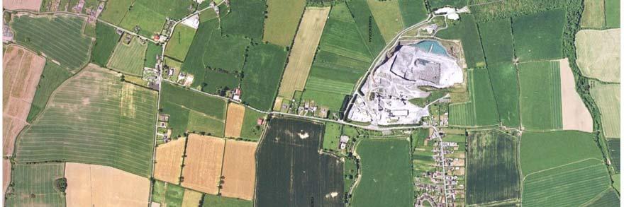
9 The other main land use in the study area is the industrial land use of Clogrennan lime, which continues to operate on an economic commercial basis and provides for a significant contribution to the employment and economic income on the study area and the county and country at large. 2.2 Residential and Settlement Pattern: Ballinabranagh: The residential development in Ballinabranagh has developed focussed on the road infrastructure with the main land use functions of the village clustered around the cross road leading north to Raheendoran and the second cross road leading south to Old Leighlin village. In this section between the two road junctions the church, school, shop, parking area, graveyard, undertaker and a few town houses are located. The original school building is located next to the church on the existing parking area with Ballinabranagh house located to the south just outside the current village form. Ribbon development can be seen on all four of the approach roads to the Ballinabranagh settlement. Only the small section of residential ribbon development on the Milford approach road fall within the functional area of the Ballinabranagh settlement. The residential ribbon halfway between Ballinabranagh and Raheendoran forms an isolated settlement of one off houses. The residential ribbon development along the western and south approach roads to Ballinabranagh also fall outside the functional area of the village settlement it provides a sprawling development pattern, and will continue to fall under the rural settlement policy as a dispersed settlement pattern. In recent times new residential development to the south west and adjacent to the south east of the church has consolidated the village settlement pattern around the settlements main focal point the Ballinabranagh Raheendoran road junction. The weight of development is now refocused on the settlement centre, which conforms to proper planning and development principles. Raheendoran: The residential development remained stable for a number of years. The settlement consists of detached dwellings on both sides of the road and a cluster of housing on the eastern end of the settlement.* The settlement is located in close proximity to the Clogrennane Lime quarry and is a settlement pattern that resulted from a history of people employed in the quarry operations living in proximity to their work. This situation has changed considerably, as most residents in the area now have no links with the lime quarry. The settlement pattern at this location is therefore inherited. Overall settlement pattern: The overall settlement pattern consists of two settlements located approximately a mile apart. Although the settlements are geographically separated they share the same social and recreational infrastructure e.g. school, church, sports fields, shop, Milford amenity area and also share physical infrastructure e.g. water, sewage, roads. The settlement conforms to the double town concept where the one settlement provides functions to the other so that together they form a sustainable development centre. Raheendoran mainly constitutes a residential settlement, which provides diversity in housing type presented. While Ballinabranagh provides for essential functions such as the school, church, sport fields, graveyard, shop. In principle the different land use functions should not be duplicated but rather provide for the strengthening of existing functions Industrial (Quarry) The industrial land is represented by the Clogrennane lime quarry. It is very long-standing industry established in The activities involve quarrying, crushing, screening, calcining, hydration, bulk storage and bagging. The industry employs 36 people directly and a number more through indirect contacting and services. The landuse can be considered to be a wellestablished land use and have a historical planning precedent and provides for important economic activity in the area and the county at large. The main locational factor that applies here is the presence of a mineral resource at the given location. The presence of disused old quarries is also seen in the area with two old derelicts sites now overgrown. The industry is located in proximity to residential development, which originally would have (as mentioned before) been linked with the quarry activities, but that relationship has now changed. The location of industrial development adjacent to suburban residential development is not ideal. A degree of friction between the land uses can be expected. In accordance with the good neighbour principle the potential impacts of the one land use on the other should be mitigated as far as reasonably possible. However the importance of the quarry industry is recognised and will be regulated under the quarry registration process recently introduced. It is also regulated by the EPA integrated pollution licence.* Carlow County Council 8
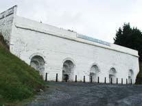
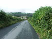
10 2.1.3 Institutional and Recreational uses: The village is served by an active primary school, large parish church, graveyard further supported by school sports pitch and a GAA field and clubhouse Open and vacant sites: A few open fields and vacant sites exist in the village, which disrupt the continuity of development. These sites present opportunities for the improvement of the village form, optimising of existing services. 2.2 Village Character on approach: The Ballinabranagh/Raheendoran village settlement area has a strong rural character, which is apparent from the settlements approaches. Ballinabranagh From the Milford road from the east: The village can be seen from a distance being elevated above the river basin on the hillside. The approach is straight up the hill and mature hedgerows align the approach. A distinct farm manor house and a one off house are the first sign of the settlement. On final approach the church and mains street town houses and large trees are visible along with a presence of houses on the north side of the road. From the west: one approaches past a ribbon of one-off houses on a winding road. The village cannot be seen until the last minute when a well kept hedgerow, a mature line of trees, a street fronting dwelling and a small village amenity area announce the settlements presence. From the south - a ribbon of one off houses is seen outside the village and on final approach the farm buildings and mature trees forms the view towards the village. From the north: along the a straight road from Raheendoran past a ribbon development of one off houses the church s front elevation behind mature trees can clearly be seen at the end of the road providing a perfect frame or focal point. Raheendoran: On approach from the south: one passes the impressive old white washed kiln structure and the settlement remains completely obscured until the old charming two storey cottage comes into view when you are already in the settlement. From the east: the Lime industry silos can be seen on the hillside and on final approach a modern bungalow can be seen above the hedgerows along the road. As the roads mainly provide a singular destination a strong sense of arrival prevails in Ballinabranagh and to a lesser degree in Raheendoran. Ballinabranagh benefits from the presence of high quality elements (although isolated) that strengthen the sense of place. Raheendoran s sense of arrival is strengthened by the presence of the impressive old limekiln structure just before the settlement and provides a surprise when the unseen settlement is reached. The main approach from the east suffers from an absence of a sense of arrival. 2.3 Topography: The Ballinabranagh/ Raheendoran village area is at elevated location set against the hillside formed by the Killeshen hills and the barrow valley. The two settlements are located at the same elevation a mile apart and provide amenity view towards the lower-lying open fields located between the two settlements. These further strengthen their relationship through a strong visual aspect. The rural amenity character of the area is formed by the open agricultural fields in-between and surrounding the settlements and is clearly delineated by the circular routes connecting the two settlements. A number of mature trees reflect the natural amenity of the hill slopes as being of woodland origin. 2.4 Hard edge Concept (promoting a building line): The need for the development of a consistent village character and sense of place will require the development of a strong building line on key frontage sites. In addition the formalisation of a streetscape along the main street in the settlement centres should be achieved. 2.5 Natural Amenity: The Ballinabranagh/ Raheendoran village area has very high level of natural and rural amenity. The lower lying open fields between the settlements are fundamental to the rural character of the area and provide important views. Excellent views are also to be had of the low-lying countryside to the east with backdrop of the Backstairs and Leinster mountains. The proximity of the Barrow river with it natural vegetation and wild life further strengthen the amenity and recreation of the area. The Clognennan woods further up the killeshen hill slopes are also a very significant amenity. Carlow County Council 9
11 2.6 Amenity and Recreation: The natural amenity is supported by recreational amenity provided through walks in the woodlands and rural country side, fishing and boating on the River Barrow, hiking along the Barrow track, bird watching, picnicking. Finally the proximity of Milford as a natural, architectural and recreational amenity provides for a full rounded amenity and recreational presence. Milford also brings tourism potential to the area. 2.7 Hedgerow /Vegetation Boundaries: A key element in the rural character of the village is the presence of existing hedgerow boundaries in the surrounding fields. These should be retained and where housing development is proposed should be retained with development being located within the existing hedgerow patterns, using them as features and shelterbelts. The retention of the hedgerow patterns is important in order to maintain the rural village character of Ballinabranagh Village and to integrate the urban area into the rural amenities (see map No. 3). * 2.8 Strategic Environmental Assessment (SEA) Scoping The proposed village plan provides for the recognition of existing land uses, the optimisation of existing services and a carefully balanced regulatory framework expressed through a zoning plan supported by policy objectives and statements aimed at achieving a sustainable balance with the surrounding environment and heritage. The proposed village plan provides for the consolidation of existing development in the form of two small residential settlements and a quarry and provides for limited additional zoned land in order to establish a sustainable village form and environment. The plan will operate at the lowest level of the plan hierarchy e.g. village plans, large village/town plans, town/city plan and then the Carlow County Development Plan, all of which are in accordance with the provision of the Planning and Development Act. 2000, proper planning and sustainable development principles and were drafted with the common good in mind. Any localised environmental effects arising from future development will be dealt with through the planning development control process with appropriate conditions being applied as necessary. Having considered the foregoing issues it is concluded that a SEA is not required in relation to this proposed village plan and that the drafts village plans policies, zonings and framework represent a sustainable approach to development that does not imply significant impact on the environment. Map No. 3 Carlow County Council 10
12 Objectives Land Use, Urban Character & Natural Heritage No. It is an objective of the Council LUNH 2-1 LUNH 2-2 LUNH 2-3 Hedgerows: To promote the retention of hedgerows as the traditional boundary form which is a characteristic of the village. These should be incorporated in future development proposals. Tree preservation orders: To encourage the preservation of significant trees and groupings of trees within the village in order to retain and encourage the woodland nature and natural screening of the village setting. Further more to examine the need for tree preservation orders where appropriate. Access: To promote accessibility to different land uses which would increase efficiency and sustainability and reduce friction. Carlow County Council 11
13 Section 3 Transportation, Infrastructure and Community 3.1 Bulk Services: The principle essential bulk services are available in the village e.g. a local road network, group water scheme and a local wastewater treatment plant (see plan No.4). 3.2 Roads: The village is well serviced by a number of minor country roads that form a localised network between the Ballinabranagh and Raheendoran settlements. The local road network allows for road links directly to Graigcullen (Carlow town- eastern banks of River Barrow), south links to Old Leighlin and new Leighlinbridge eastwards past Millford via Millford cross to Tinryland and to the west minor roads lead through the Killeshenhills to Laois and Kilkenny. The study area itself presents a good road network, with a distinctive circular route between Ballinabranagh, Clogrennan, Raheendoran, Millford and back to Ballinabranagh and open agricultural fields in between providing for the distinctive rural amenity setting of the area. Local roads are also used as a rural pedestrian walkways that provide recreation an amenity for the local residents. 3.3 Waste Water Infrastructure: A new wastewater treatment plant has been installed in Cloydagh and serves both Ballinabranagh and Raheendoran. A gravity feed pipe runs through Raheendoran and serves the existing dwellings and the adjoining new housing scheme development in Ballinabranagh. Ballinabranagh church, school, shop or GAA clubhouse are not served by this foul sewer but the favourable topography of the area offers the potential to extend the sewer pipe to the west, south and north through the village core area. The new effluent treatment plant can currently cater for a maximum number of 500 persons. Given the recent development of 2no. housing schemes in Ballinabranagh (one a 45 dwelling scheme and the other a 18no. serviced site scheme) and demand for further such developments the capacity of the effluent disposal unit to cater for additional development is limited. It is therefore clear that all significant further development will be dependant on the upgrading of the existing sewage plant to cater for future needs. There is the potential for this upgrade as the effluent disposal plant is on a 1 acre site and can be upgraded to cater for a maximum of 1,000 persons. It is important that all future development be connected to the main sewage line to ensure sustainability and the proper planning and development of the village. The provision of individual sewage facilities will not be supported for future developments in the village while the council shall encourage existing individual facilities to link up with the sewage line.* Carlow County Council 12
14 3.4 Water Infrastructure: The settlements of Ballinabranagh and Raheendoran and environs are well served by an existing Group Water Scheme (GWS). This scheme is essentially in private ownership and formal consent must be sought in order to connect into it. The Ballinabranagh Goup Water Scheme is in the SLDBO (South Leinster Design Build & Operate) water project. This involves the upgrading of the current GWS for the next 20 years. A design review of the scheme was carried out in 2004 and this estimated that there were 249 domestic connections and 6 non-domestic connections. The daily demand at that stage was 290m3/day with an estimated unaccounted water level of 32%. The proposed treatment plant will have a capacity to treat 450m3/day and this allows for a 100% increase in the number of domestic connections. As part of the advance works a 450m3 reservoir has been constructed. This inter alia is a positive indicator for the future provision of a potable, high quality and sustainable water supply to serve both Ballinabranagh & Raheendoran. Note however the primary responsibility of the scheme is with existing Group Water Scheme members. A limiting factor to the number of houses that the scheme will be able to supply is the existing network part of which is experiencing pressure and flow problems. Large sections of the network are supplied by 2" pipes that are at or near capacity. There are grants available for the Group to upgrade the network and it is anticipated that this work would follow on from the main DBO project. 3.5 Social and Recreational Infrastructure: Ballinabranagh/ Raheendoran village area has a number of essential services present the form of the Church, school, small shop, an existing GAA field and clubhouse. There is currently no social or community hall in use and the only facility available in this regard is the GAA clubhouse. A clear need for a village park has been identified in the plan and the provision of additional sports fields. Future developments shall be required to provide adequate and sustainable solutions to the provision of high quality social and recreational services for future and present residents of the village. Business in the settlements is also very limited and the provision of activities that can provide essential products are considered in the local area plans. Through the public participation process and consultation a need was identified to bring the communities closer together in this regard provision for additional sports fields have been made halfway between the two settlements, linked with a green path pedestrian walkway. This could then become more formalised within the urban settlements and further contributes by linking the future provision of public open space in the settlements with each other. Carlow County Council 13
15 Objectives No. It is an objective of the Council TIC 3-1 TIC 3-2 Transportation, Infrastructure and Community Available infrastructure: Future development shall be subject to the availability and adequate provision of the necessary physical infrastructure and specifically be subject to the upgrading of the existing sewage plant to a level that can accommodate future development and population increases. Sewage Plant: All future development shall be required to contribute towards the upgrading of the existing sewage plant through direct private investment and development contribution or a public private partnership development scheme. In this context future development could only be considered favourably where sufficient capacity has been created or will be available to serve a given development. TIC 3-3 TIC 3-4 TIC 3-5 TIC 3-6 Social & Recreational Infrastructure: To promote the improvement of existing social and recreational infrastructure within appropriately designated areas in the village e.g. village park, play areas, sports fields, community hall etc. Traffic Calming Measures: To consolidate the existing and assess the need for future traffic calming measures in relation to existing and future projected traffic generation in the village and give due consideration to the need to establish a safe and quality village environment and village character. Road setbacks: To improve and widen as necessary roads in the area and to require adequate set back of developments to facilitate road improvements. Traffic impact: To minimise the traffic impact from industrial activities in the area. Map No. 4 Carlow County Council 14
16 Section 4 Urban Design, Heritage & Opportunity Sites 4.1 Opportunities Sites & Development Guidelines: Opportunity site No.1 Urban Mixed use and Village Park area in the Ballinabranagh settlement located on the eastern side of the Raheendoran road junction. The site consists of an open agricultural flied adjacent to the existing national school, church and new residential estate. Development Guidelines: Ballinabranagh The development of a village park integrated with the development of business and commercial and residential included under the urban mixed use zoning. The residential component should not exceed 40% of the site area not including the village park area. The village park should be located on the south western corner of the site to provide a high degree of accessibility and to strengthen the focal point created by the church front elevation and the road junction. A mix of business activities forming a streetscape development with the main elevations looking into a village park Provision should be made for well landscaped parking bays, which will provide access to both the business activities and the town park recreational amenities. Architecture design and character should be sensitive to the existing character of buildings in the village and the immediate area. This area together with the urban mixed use zoning to the north shall act as the future village centre for economic activities, while focussing on a village park. Landscaping shall have regard of the woodland amenity character of the general area. A formalised pedestrian walkway designed through both hard and soft landscaping shall be provided along the western site boundary with a minimum width of 5 meter. The pedestrian-walk way shall lead from the village in the direction of Raheendoran in order to initiate linkage between the village park, zoned community sport fields and the zoned public open space in Raheendoran along the zoned green path Opportunity site No.2 This opportunity site is located in the Raheendoran settlement at the entrance to the village from the eastern approach road. The site consists of open agricultural fields adjacent to existing residential estate on the southern side of the road and existing detached dwellings on the northern side of the road. Development Guidelines: Raheendoran: The opportunity site includes low density residential, a small business site and public open space. Their should be preference for the provision of serviced sites with the dwelling to be located on the exterior periphery of the zoned area so orientated as to present a significant elevation outwards from the village to strengthen the village architectural character. The business is envisaged to provide for essential consumer goods for the local population. The public open space should be developed to provide public recreation and amenity. A formalised pedestrian walkway designed through both hard and soft landscaping should be provided along the western site boundary with a minimum width of 5 meter. The pedestrian-walk way shall lead from the public opens pace in the direction of Ballinabranagh in order to initiate linkage between the public open space, zoned community sport fields and the zoned village park in Ballinabranagh along the zoned green path. Carlow County Council 15
17 4.1.3 Opportunity site No, 3 This site is located at Fonthill half way between the settlements of Ballinabranagh and Raheendoran on the eastern side of the road at the location of the historic sport ground in the area. The site currently consist of open agricultural fields located adjacent to a national monument (ring fort) Development Guidelines: The zoned area is aimed at the provision of additional community sports fields and facilities, which will serve as communal grounds for the two communities together. The sports field should be managed by a joint body formed by an equal representative from both communities. Sporting facilities and sports pitches at this location should be able to cater for a variety of sporting needs in the village in an efficient and sustainable manner. The landscaping proposals associated with the sports grounds integrate with the ring fort monument adjacent to the south of the zoned area. A pedestrian green path with a minimum width of 5 meter shall be provided on the western boundary initiating linkage between the settlements. The pedestrian-walk way shall lead from the communal sport grounds in the direction both to the north to Raheendoran and to the south to Ballinabranagh in order to initiate linkage between the public open space, village park, the two settlements along the zoned green path.* 4.2 Archaeology: A few archaeological recorded monument sites are located in the area these have been afforded with a circular buffer area that applies to each, radius of 30m, to ensure that due regard is had to their heritage. If such a monument falls within the village boundaries, preference shall be given to incorporating this location in public or private open spaces areas. Future development in proximity to any recorded monument shall have be subject to archaeological monitoring and surveying. The recorded monuments in the immediate area are: i) Monument no. CW is an Enclosure located within an exiting housing scheme to the immediately east of the village Church. No visible remains of same are evident. ii) Monument no s CW , CW & CW are an Enclosure, a Miscellaneous Site and a Metal Working Site located to the east and southeast of the village on tilled agricultural lands and grassland. No visible remains of same are evident. iii) Monument no. CW is an Enclosure located to the rear of an existing house row set 500 metres south of the western village cross roads. No visible remains of the Enclosures is evident. iv) Monument no. CW is the remains of a Ringfort/ Cashel and is located 150 metres northeast of Ballinabranagh house and adjoining far buildings. The Ringfort remains are visible. Carlow County Council 16
18 Objectives Urban Design, Heritage & Opportunity Sites No. It is an objective of the Council UHO 4-1 Entrances and Gateways to Village To promote the development of defined entrances to Ballinabranagh and Raheendoran settlements and strengthen the sense of arrival when entering the village i.e. i) The establishment of landscaped pocket parks/amenities or village amenity areas. ii) The improvement of the southern, eastern and northern approach roads to provide a sense of arrival in the village e.g. streetscape, landscaped amenity, feature etc. UHO 4-2 UHO 4-4 UHO 4-5 UHO 4-6 Screening & Woodland Character To screen future village developments from the surrounding countryside through the provision of adequate landscaping, hedgerows and maintaining the woodland character of the village areas Screening & Woodland Character To screen future village developments from the surrounding countryside through provision of adequate landscaping, hedgerows and maintaining the rural character of the village. Architecture, Built & Architectural heritage features: To support the retention of buildings with architectural merit, significant architectural features, historic/heritage structures and archaeological sites that contributes to the village character and setting. Sports fields and facilities To encourage the upgrading of sporting facilities in conjunction with local sports clubs and the local community. In this regard a partnerships approach shall be encouraged to ensure that investment is maintained in the social and recreational facilities in the village and that sporting facilities are able to cater for a variety of sporting needs in the village in an efficient and sustainable manner. Map No. 5 Carlow County Council 17
INSERT MAP ACCORDING TO SCALE
 INSERT MAP ACCORDING TO SCALE Map No. 6 Carlow County Council 14 5.3 Zoning Definition and Zoning objectives ZONE Low-density Residential: consideration Medium Residential Consideration Urban Mixed Use
RATHOE VILLAGE DRAFT LOCAL AREA PLAN
 RATHOE VILLAGE DRAFT LOCAL AREA PLAN Section No. & Page 1. Introduction 1.1. Legal Preamble 1.2. Carlow County Development Plan policy objectives 1.3. The Process & Supporting Documents 1.3.1. Public Submissions
CLOUGHJORDAN SETTLEMENT PLAN
 CLOUGHJORDAN SETTLEMENT PLAN 1.0 General Introduction and Development Context Location The market town of Cloughjordan lies close to the border with Offaly at the junction of the R490 and R491 Regional
TINRYLAND VILLAGE LOCAL AREA PLAN. Doc. Tinryland Village LAP (11 final adopted) 21/06/2006
 21/06/2006") TINRYLAND VILLAGE LOCAL AREA PLAN Doc. Tinryland Village LAP (11 final adopted) 21/06/2006 Section No. & Page 1. Introduction 1.1. Legal Preamble 1.2. Carlow County Development Plan policy objectives 1.3.
TINRYLAND VILLAGE LOCAL AREA PLAN Doc. Tinryland Village LAP (11 final adopted) 21/06/2006 Section No. & Page 1. Introduction 1.1. Legal Preamble 1.2. Carlow County Development Plan policy objectives 1.3.
6. Ballintogher Mini-Plan
 County Development Plan 2017-2023 Consolidated Draft + Adopted Amendments August 2017 Volume 2, Chapter 6 Ballintogher Mini-Plan 6. Ballintogher Mini-Plan Village profile Ballintogher is located approximately
GRANGE/KILLERIG VILLAGE LOCAL AREA PLAN
 GRANGE/KILLERIG VILLAGE LOCAL AREA PLAN Doc. Grange-Killerig Village Plan (10) 22/11/2005 Section No. & Page 1. Introduction 1.1. Legal Preamble 1.2. Carlow County Development Plan policy objectives 1.3.
BORRISOKANE SETTLEMENT PLAN
 BORRISOKANE SETTLEMENT PLAN 1.0 General Introduction and Development Context Location Borrisokane is located 15km north of Nenagh on the N52. While the town is primarily residential, it acts as a market
6 PORT SYDNEY SETTLEMENT AREA
 Section 6 Port Sydney Page 61 6 PORT SYDNEY SETTLEMENT AREA 6.1 Basis and Principles Village of Port Sydney Waterfront Community Existing Services 6.1.1 Port Sydney is an historic settlement that has developed
20. Ballysadare Mini-Plan
 20. Ballysadare Mini-Plan 20. Ballysadare Mini-Plan Community facilities Ballysadare has a wide range of community facilities: a primary school, St Mary s College (secondary school), a health centre, playing
28. Coolaney-Rockfield Mini-Plan
 28. Coolaney-Rockfield Mini-Plan 28. Coolaney-Rockfield Mini-Plan Community facilities Community facilities in Coolaney-Rockfield consist of a primary school, crèche, community centre, sports field and
17. Coolaney-Rockfield Mini-Plan
 County Development Plan 2017-2023 Consolidated Draft + Adopted Amendments - August 2017 17. Coolaney-Rockfield Mini-Plan Village profile Coolaney is located approximately 23 km to the south-west of Sligo
LONGDEN VILLAGE DEVELOPMENT STATEMENT
 LONGDEN VILLAGE DEVELOPMENT STATEMENT 2017-2027 1 Longden Development Statement 2017-2027 15/01/18 1. Background 1.1 Longden Village Longden village is a very rural and traditional community first mentioned
About 10% of the Borough's population lives in the seven rural parishes. Population figures from the 1991 census are given below:-
 8. THE DISTRICT VILLAGES 8.1 Population About 10% of the Borough's population lives in the seven rural parishes. Population figures from the 1991 census are given below:- Village No. of Persons Cottingham
A Growing Community Rural Settlement Areas
 Town of Huntsville Official Plan Review - POLICY BACKGROUND PAPER A Growing Community Rural Settlement Areas BACKGROUND: In addition to the fully municipally-serviced Urban Settlement Area and the Hidden
Page 1 of 19 URBAN DESIGN FRAMEWORK FOR BOLTON STREET WATERFORD
 Page 1 of 19 URBAN DESIGN FRAMEWORK FOR BOLTON STREET WATERFORD 1.0 Introduction: The relocation of the City Council stores and depot from Bolton Street creates an exciting opportunity for development
County Development Plan Consolidated Draft + Adopted Amendments August 2017 Volume 2, Chapter 22 Easky Mini-Plan
 22. Easky Mini-Plan Village profile Easky is a coastal settlement located approximately 40 km to the west of Sligo City, in a designated Rural Area In Need of Regeneration. The nearby coastline is designated
The Proposed Auckland Unitary Plan (notified 30 September 2013)
") 3 Business zones Introduction There are 10 business zones in the Unitary Plan: City Centre Metropolitan Centre Town Centre Local Centre Neighbourhood Centre Mixed Use General Business Business Park Light
3 Business zones Introduction There are 10 business zones in the Unitary Plan: City Centre Metropolitan Centre Town Centre Local Centre Neighbourhood Centre Mixed Use General Business Business Park Light
Case Studies; Meitheal Clusters Applied to Villages and Rural Settlements
 Case Studies; Meitheal Clusters Applied to Villages and Rural Settlements 23.3.9 (ii) Case Studies, Meitheal Clusters applied to villages and rural settlments Fig 22.3.12 Cluster site plan; church opposite
MOUNT AVENUE MASTERPLAN WORKING DRAFT NOVEMBER 2006
 MOUNT AVENUE MASTERPLAN WORKING DRAFT NOVEMBER 2006 1 1. OVERALL MASTERPLAN IDENTITY: Dun Dealgan motte and bailey The Dun Dealgan motte and bailey, a national monument, is located to the north east of
Welcome to our exhibition
 Welcome to our exhibition The Homes & Communities Agency (HCA) welcomes you to this public exhibition explaining our proposals for the redevelopment of the former Lea Castle Hospital site. About the Homes
Submission to the Kildare County Council Development Plan North Kildare Chamber. Executive Summary
 ` 28 th May 2015 Submission to the Kildare County Council Development Plan 2017-2023 North Kildare Chamber Executive Summary North Kildare Chamber s mission is to work with businesses, community groups,
30. Riverstown Mini-Plan
 County Development Plan 2017-2023 Consolidated Draft + Adopted Amendments August 2017 Volume 2, Chapter 30 Riverstown Mini-Plan 30. Riverstown Mini-Plan Village profile Riverstown is located approximately
Drrumconrratth Wrriitttten Sttattementt. Position in Settlement Hierarchy Village - Local centre for services and local enterprise development
 Drrumconrratth Wrriitttten Sttattementt Settlement Drumconrath Position in Settlement Hierarchy Village - Local centre for services and local enterprise development Position in Retail Strategy Level 4
Public Consultation. Land at Monks Farm, North Grove. Welcome
 Welcome Welcome to our public exhibition for development on Land at Monks Farm, orth Grove. Gallagher Estates and Gleeson Strategic Land are preparing an outline planning application for new homes, open
Newcourt Masterplan. November Exeter Local Development Framework
 Newcourt Masterplan November 2010 Exeter Local Development Framework Background The Exeter Core Strategy Proposed Submission sets out the vision, objectives and strategy for the development of Exeter up
WELCOME GYPSY LANE. Wider Site Location plan. Proposals for the development of LAND OFF FOXLYDIATE LANE WEBHEATH. Proposals for the development of
 WELCOME The developers are preparing an outline planning application for a residential led development and need the community s views in order to develop the proposals further WHAT IS PROPOSED? A high
2.0 Strategic Context 4
 2.0 Strategic Context 4 2.1 The Area Action Plan is a non-statutory plan, which forms a corporate policy document, expressing particular issues and areas of concern while also providing a vision for the
INTRODUCTION. Land south of Bishopswood Lane, Tadley
 0 INTRODUCTION THE SITE Introduction Gladman Developments Ltd. has successfully invested in communities throughout the UK over the past 0 years, developing high quality and sustainable residential, commercial
SPG 1. * the northern and western sections which are open fields used for pasture and grazing;
 SPG 1 1.0 INTRODUCTION This development brief is based on the allocation of the Priors Hall site for employment and countryside recreational purposes in the Corby Borough Local Plan. The brief is intended
8.0 Design and Form of Development 43/
 42/ 8.0 Design and Form of Development 43/ Rothwells Farm, Golborne/ Development Statement Figure 7. Site Constraints Key 44/ Site Boundary 360 Bus Route/Stops Existing Trees Underground Water Pipe Sensitive
INTRODUCTION. Land West of Main Road, Stanton Harcourt THE SITE. Why is the Site Suitable for Development?
 0 INTRODUCTION THE SITE Application Boundary Gladman Developments Ltd has successfully invested in communities throughout the UK over the past 0 years, developing high quality and sustainable residential,
Tāhuhu whakaruruhau ā-taone The sheltering ridge pole
 B2. Tāhuhu whakaruruhau ā-taone - Urban growth and form B2.1. Issues Tāhuhu whakaruruhau ā-taone The sheltering ridge pole Auckland s growing population increases demand for housing, employment, business,
[PLANNING RATIONALE] For Site Plan Control and Lifting of Holding Zone By-Law 101 Champagne Avenue. May 23, 2014
![[PLANNING RATIONALE] For Site Plan Control and Lifting of Holding Zone By-Law 101 Champagne Avenue. May 23, 2014](/thumbs/75/71599615.jpg "[PLANNING RATIONALE] For Site Plan Control and Lifting of Holding Zone By-Law 101 Champagne Avenue. May 23, 2014") [PLANNING RATIONALE] For Site Plan Control and Lifting of Holding Zone By-Law 101 Champagne Avenue May 23, 2014 Contents 1.0 Introduction... 2 2.0 Site Context... 2 2.1 Adjacent Uses... 2 Figure 1: Site
[PLANNING RATIONALE] For Site Plan Control and Lifting of Holding Zone By-Law 101 Champagne Avenue May 23, 2014 Contents 1.0 Introduction... 2 2.0 Site Context... 2 2.1 Adjacent Uses... 2 Figure 1: Site
CORK County Development Plan 2003
 3 VOLUME 3 Specific Zoning Main Settlements Zoning Main Settlements Contents of Volume 3 Settlement 1: BALLINCOLLIG TEXT MAP Settlement 2: BANDON TEXT MAP Settlement 3: BANTRY TEXT MAP Volume 1: Overall
WELCOME. Land North of STEVENAGE. We would like to thank you for attending our public exhibition today.
 WELCOME We would like to thank you for attending our public exhibition today. The purpose of this event is to share our proposals and hear your thoughts on our ideas. Members of the project team are on
Site Assessment Technical Document Appendix A: Glossary
 Central Bedfordshire Council www.centralbedfordshire.gov.uk Site Assessment Technical Document Appendix A: Glossary July 2017 1.1.11-1 - ii Appendix A: Glossary Term Agricultural Land Classification AONB
Tiane Ltd Submission on Draft National Planning Framework Ireland 2040
 Tiane Ltd Submission on Draft National Planning Framework Ireland 2040 Date: 31 st March 2017 Authors: Ken Swaby / Ben Waite Approved By: Christy O'Sullivan ILTP Project Code & Reference: GOLDENATH Distribution:
RURAL ZONE - POLICY. Rural Zone Policy. Issue: Rural Environment. Ruapehu District Plan Page 1 of 8
 Rural Zone Policy RU2 RURAL ZONE - POLICY RU2.1 Introduction The natural resources of the rural environment in the Ruapehu District provide the basis for the existing and potential character, intensity
elbridge Core Strategy
 C elbridge Core Strategy Celbridge is designated as a Moderate Growth Town in the RPGs. The County Development Plan reinforces this designation in its settlement strategy. Moderate Growth Towns within
2. Aughrim Town Plan. Wicklow County Development Plan Context. Level 5 Town Plans Aughrim
 2. Aughrim Town Plan 2.1 Context Aughrim is a small attractive town in south County Wicklow. It lies in a scenic valley where the Ow and Derry rivers meet to form the. The town is on the R747 regional
EVALUATION OF MASTER PLAN ALTERNATIVES
 7 The Environmental Report is required to identify, describe and evaluate reasonable alternatives, taking into account the objectives and geographical scope of the Master Plan 2008. Three plan alternatives
WELCOME. Olney Road, Lavendon INTRODUCTION. The Site. The Application. The Need for Housing. A Sustainable Location LAVENDON TURVEY OLNEY ROAD
 0 WELCOME INTRODUCTION Gladman Developments Ltd have successfully invested in communities throughout the UK over the past 0 years, developing high quality and sustainable residential, commercial and industrial
Carton Avenue Action Area Plan Maynooth
 Carton Avenue Action Area Plan Maynooth Kildare County Council JULY 2006 (AAP) Table of Contents Section 1. Introduction...3 Statement of Strategy...3 Location of the Lands...3 Context in the Town Development
WELCOME. Land west of Great Canfield Road, Takeley. Welcome. Have your say. Pegasus Urban Design
 01 WELCOME Welcome Gladman Developments Ltd have successfully invested in communities throughout the UK over the past 20 years, developing high quality and sustainable residential, commercial and industrial
Chapter 5 Urban Design and Public Realm
 5.1 Introduction Public realm is all areas of the urban fabric to which the public have access. It is where physical interaction takes place between people. It therefore, includes buildings and their design,
Welcome. Land adjacent Sandy Lane WALTHAM CHASE THE PROPOSED SITE
 Land adjacent Sandy Lane WALTHAM CHASE Existing Linden Homes developments Welcome Welcome to Linden Homes Southern s ( Linden ) public exhibition about its proposals for a range of high-quality homes for
14.5 HOPEFIELD: (REFER PLAN 39 AND PLAN 40)
") URBAN DYNAMICS WESTERN CAPE INC. 248 14.5 HOPEFIELD: (REFER PLAN 39 AND PLAN 40) FIGURE 83: LOCALITY - HOPEFIELD Within the context of the Saldanha Bay Municipal area, Hopefield, an historical agricultural
URBAN DYNAMICS WESTERN CAPE INC. 248 14.5 HOPEFIELD: (REFER PLAN 39 AND PLAN 40) FIGURE 83: LOCALITY - HOPEFIELD Within the context of the Saldanha Bay Municipal area, Hopefield, an historical agricultural
I539. Smales 2 Precinct
 I539. Smales 2 Precinct I539.1. Precinct Description The Smales 2 Precinct applies to a 4.8 hectare block of land located on the southern side of Northcote Road and fronting Lake Pupuke, Takapuna. The
Neighbourhood Plan Representation
 Date: 10 th November 2017 Neighbourhood Plan Representation Land to the east of Callow Hill Road, Alvechurch Introduction This representation has been prepared by RPS Planning and Development on behalf
Toddington Central Bedfordshire Stage 3 Green Belt Study December 2017
 Toddington Central Bedfordshire Stage 3 Green Belt Study December 2017 Site: ALP086 - Middle Lakes, Toddington Site size (ha): 2.83 Site: ALP086 - Middle Lakes, Toddington Site size (ha): 2.83 Site description
Urban Design Guidelines
 Urban Design Guidelines These Urban Design Guidelines comprise the Key Design Objectives below, the Roads Design Guidelines overleaf and Neighbourhood Framework Plans. Together with Section 3: Urban Design
SUSTAINABLE MANAGEMENT
 . Sustainable Management.1 The Concept of Sustainable Management The concept of sustainable management recognises there are limits to the use of natural and physical resources and there is a need to balance
Ensure that development within the Arrowtown Urban Growth Boundary provides:
 URBAN DEVELOPMENT 4 4.2.5.2 Ensure that development within the Arrowtown Urban Growth Boundary provides: an urban form that is sympathetic to the character of Arrowtown, including its scale, density, layout
3. Neighbourhood Plans and Strategic Environmental Assessment
 1. Introduction This report sets out a draft Screening Determination for the Preston Parish Council s Neighbourhood Plan and has been prepared by rth Hertfordshire District Council. The purpose of the
Colchester Northern Gateway Master Plan Vision Review Draft. July 2016
 Colchester Northern Gateway Master Plan Vision Review Draft July 2016 Contents Introduction 4 Context 8 Purpose of the Report 8 Strategic Position 9 Overview of the Process 11 2012 Master Plan Vision 12
3.0 Area-Wide Strategies 30
 3.0 Area-Wide Strategies 30 3.6 Tourism Strategy This section of the plan aims to develop and improve the tourism potential of the area. Strategic Context The City Plan outlines the potential of Cork to
DUNSFOLD NEIGHBOURHOOD PLAN Site Selection Policies
 DUNSFOLD NEIGHBOURHOOD PLAN Site Selection Policies The criteria for assessing sites for future housing and business development in Dunsfold are set out below. (Development criteria, covering what it is
4.3 Dudley Area Plan. Introduction. History and Existing Character. Desired Future Character for Dudley
 4.3 Dudley Area Plan Introduction The suburb of Dudley has developed as a result of various circumstances including its topography, history and mineral resources. Dudley development has been identified
Examination of South Cambridgeshire Local Plan
 Matter SC6A - Policy SS/5 Waterbeach New Town Historic England( formerly English Heritage) 874 Rep Nos 59748, 60250, 60253 Examination of South Cambridgeshire Local Plan Historic England, Hearing Statement
Woodbrook - Shanganagh
 Section 4: Key Sites Framework Strategy Woodbrook - Shanganagh Local Area Plan 2017-2023 4. Site Framework Strategies The Master Plans shall have regard to the thematic objectives under the LAP Development
Mark-up of the effect of the proposed Bronte Village Growth Area OPA No.18 on the text of section 24, Bronte Village, of the Livable Oakville Plan
 Mark-up of the effect of the proposed Bronte Village Growth Area OPA No.18 on the text of section 24, Bronte Village, of the Livable Oakville Plan Notes: This document is provided for information purposes
2. Spatial Portrait, Vision and Objectives
 VISION & OBJECTIVES 2. Spatial Portrait, Vision and Objectives Introduction 2.1 This section sets out the spatial portrait of Uttlesford, the vision we have for the future of the area and the objectives
Neighbourhood Planning Guidance Local Green Spaces
 Neighbourhood Planning Guidance Local Green Spaces Introduction This guidance note has been produced for communities preparing neighbourhood plans in North Dorset to help them to identify, assess and designate
Schedule of Planning Applications Committee Date: 23 May Reference: 06/17/0726/F Parish: Hemsby Officer: Mr J Beck Expiry Date:
 Schedule of Planning Applications Committee Date: 23 May 2018 Reference: 06/17/0726/F Parish: Hemsby Officer: Mr J Beck Expiry Date: 22-05-2018 Applicant: Proposal: Site: Mr Gillett Change of use to the
Droitwich Spa 6. Reasoned Justification
 87 Droitwich Spa 6 Reasoned Justification 6.1 Droitwich Spa is identified in the settlement hierarchy (Policy SWDP1) as a main town being the largest settlement in Wychavon District with an estimated population
Welcome to our public exhibition
 About our development Welcome to our public exhibition This exhibition gives you the chance to view and comment on our proposals for a new residential development of 165 high-quality homes, along with
HOROWHENUA DEVELOPMENT PLAN June create a safe crossing for children moving to and from the school and other areas. 7.8 Ohau
 7.8 Ohau create a safe crossing for children moving to and from the school and other areas. Ohau has a traditional village form with a collective of school, church and reserve at the main road intersection.
Issue 1 Protection of the special environmental qualities of the Hanmer Basin.
 Environments of special concern Issue 19 Hanmer Basin The Hanmer Basin is a special area, being a popular retirement and holiday destination as well as having considerable environmental and conservation
New Homes at Winton East
 View toward Winton East from Caerketton Hill Aerial photograph of South Edinburgh: Winton East Site Location Indicative proposal Welcome Thank you for coming to the Winton East public exhibition. We would
Suffolk Coastal Local Plan Review Issues and Options, August 2017, Public Consultation
 Suffolk Coastal Local Plan Review Issues and Options, August 2017, Public Consultation Having reviewed the issues and options documents, the Society has made the following response: Part 1 - Strategic
Rathmolyon Written Statement
 Settlement Rathmolyon Position in Settlement Hierarchy Village - Local centre for services and local enterprise development Position in Retail Strategy Fourth tier retail centre Population (2011) Census
Land at Rampton Road. Cottenham
 Land at Rampton Road Cottenham Introduction TEP is preparing an outline planning application for 54 dwellings on 6.9 hectares of land adjacent to Rampton Road, Cottenham on behalf of the owners Cambridgeshire
Plumpton Neighbourhood Development Plan Revised Pre Submission Document - Regulation 14 Consultation
 REPRESENTATIONS... Plumpton Parish Council Plumpton Neighbourhood Development Plan Revised Pre Submission Document - Regulation 14 Consultation Representations submitted on behalf of: Cala Homes (South
Emmer Green, Reading. Site Location Plan
 0 Welcome Introduction Gladman Developments Ltd have successfully invested in communities throughout the UK over the past 0 years, developing high quality and sustainable residential, commercial and industrial
Settlement Boundaries Methodology North Northumberland Coast Neighbourhood Plan (August 2016)
") Introduction This background paper sets out a methodology for the definition of settlement boundaries in the North Northumberland Coast Neighbourhood Plan. The neighbourhood plan is planning positively
Introduction This background paper sets out a methodology for the definition of settlement boundaries in the North Northumberland Coast Neighbourhood Plan. The neighbourhood plan is planning positively
Alder View. Introduction. Alder View. Harwell. The Vision. The Team. Taylor Wimpey
 Introduction Welcome to the public exhibition for, a development by Taylor Wimpey on the land south of Grove Road,. This exhibition will provide an overview of the development proposals for the site and
Chapter 3 Core Strategy
 Chapter 3 Core Strategy 3.0 Introduction The core strategy sets out how the development objectives in the Development Plan are consistent with the National Spatial Strategy and the Regional Planning Guidelines.
STATEMENT OF OBJECTION TO THE PROPOSED DEVELOPMENT OF LAND AT CHURCH CLIFF DRIVE FILEY
 STATEMENT OF OBJECTION TO THE PROPOSED DEVELOPMENT OF LAND AT CHURCH CLIFF DRIVE FILEY You will be aware that Scarborough borough council have adopted a new local plan that includes land at Church Cliff
HARDWICK GREEN, King s Lynn. Welcome to our Exhibition. What are your views? Introduction to the site and proposals. About us
 HARDWICK GREE, King s Lynn Welcome to our Exhibition Welcome to our exhibition, which is being held to provide you with the opportunity to understand and comment upon our proposals for new residential
Neighbourhood Planning Local Green Spaces
 Neighbourhood Planning Local Green Spaces Introduction... 2 1. Why green space is important... 4 2. Neighbourhood plans and green space... 6 3. Evidence... 8 Statutory designations... 9 Green space audit...
1. Objectives of this consultation
 1. Objectives of this consultation Provide an update on the results of the December 2014 consultation Provide a summary of the Pre-Submission Plan which is now out for formal consultation To ask for your
Plan Modification to Chapter B2 of the Auckland Unitary Plan(AUP) Operative in part (15 November 2016)
 Operative in part (15 November 2016)") UNITARY PLAN UPDATE REQUEST MEMORANDUM TO FROM Phill Reid Linley Wilkinson DATE 25 September 2018 SUBJECT Plan Modification to Chapter B2 of the Auckland Unitary Plan(AUP) Operative in part (15 November
UNITARY PLAN UPDATE REQUEST MEMORANDUM TO FROM Phill Reid Linley Wilkinson DATE 25 September 2018 SUBJECT Plan Modification to Chapter B2 of the Auckland Unitary Plan(AUP) Operative in part (15 November
ROCHFORD LOCAL DEVELOPMENT FRAMEWORK: Sustainability Appraisal/ Strategic Environmental Assessment. Rochford Core Strategy Preferred Options Document
 ROCHFORD LOCAL DEVELOPMENT FRAMEWORK: Sustainability Appraisal/ Strategic Environmental Assessment Non Technical Summary Rochford Core Strategy Preferred Options Document October 2008 SUSTAINABILITY APPRAISAL
VILLAGE OF BOLTON HERITAGE CONSERVATION DISTRICT PLAN
 Page 1 1. INTRODUCTION AND BACKGROUND 1.1 THE PROJECT VILLAGE OF BOLTON HERITAGE CONSERVATION DISTRICT PLAN TERMS OF REFERENCE The Town of Caledon (Town) is a large, predominantly rural municipality with
5.0 VILLAGE AREAS. February 2008 Municipality of West Elgin ~ Official Plan 5-1
 5.0 VILLAGE AREAS This section of the Official Plan deals with the villages of Rodney and West Lorne being the two largest and only fully serviced settlement areas in West Elgin and the most logical and
INCREMENTAL CHANGE AREA REVIEW March 2015 Page 1
 INCREMENTAL CHANGE AREA REVIEW March 2015 Page 1 Table of Contents Introduction... 3 Background to Review... 3 Comparison of the Schedules to the General Residential Zone... 7 Methodology... 7 Policy Context...
Ballivor Written Statement
 Settlement Ballivor Position in Settlement Hierarchy Village - Local centre for services and local enterprise development Position in Retail Strategy Fourth tier retail centre Population (2011) Census
FORMER CANADIAN FORCES BASE (CFB) ROCKCLIFFE SECONDARY PLAN. Official Plan Amendment XX to the Official Plan for the City of Ottawa
 ROCKCLIFFE SECONDARY PLAN. Official Plan Amendment XX to the Official Plan for the City of Ottawa") FORMER CANADIAN FORCES BASE (CFB) ROCKCLIFFE SECONDARY PLAN Official Plan Amendment XX to the Official Plan for the City of Ottawa 1 INDEX THE STATEMENT OF COMPONENTS PART A THE PREAMBLE PAGE Purpose...
FORMER CANADIAN FORCES BASE (CFB) ROCKCLIFFE SECONDARY PLAN Official Plan Amendment XX to the Official Plan for the City of Ottawa 1 INDEX THE STATEMENT OF COMPONENTS PART A THE PREAMBLE PAGE Purpose...
NEW CASTLE COUNTY S ZONING DISTRICTS
 NEW CASTLE COUNTY S ZONING DISTRICTS This is general information about New Castle County s zoning districts. The information included is by no means exhaustive or complete. Before designing plans to develop
Commercial, Retail and Tourism Executive Summary December 2018
 Town of Wasaga Beach Official Plan Review, Retail and Executive Summary December 2018 1 An Official Plan directs where and how to grow The preparation of a new Official Plan for Wasaga Beach is an opportunity
YONGE STEELES CORRIDOR SECONDARY PLAN. Young + Wright / IBI Group Architects Dillon Consulting Ltd. GHK International (Canada) Ltd.
 Ltd.") PART A: PREAMBLE 1.0 PURPOSE The purpose of this Secondary Plan is to provide a development framework for intensification of the Yonge/ Steeles corridor including the north side of Steeles Avenue West
PART A: PREAMBLE 1.0 PURPOSE The purpose of this Secondary Plan is to provide a development framework for intensification of the Yonge/ Steeles corridor including the north side of Steeles Avenue West
Croftamie has a limited range of services and facilities and has close links with neighbouring Drymen.
 CROFTAMIE Croftamie has a limited range of services and facilities and has close links with neighbouring Drymen. Sense of Place Croftamie is a small rural village characterised by a linear low density
3. Kilmacanogue Settlement Plan
 . Settlement Profile he town of Kilmacanogue is located at the junction of the R to Roundwood and the N, km south of Bray town centre. Kilmacanogue is located equidistant between the Little Sugar Loaf
Environmental and Landscape Mapping
 Environmental and Landscape Mapping In support of the Calveley Neighbourhood Plan November 2016 Project Name and Number: Calveley Neighbourhood Plan 16-025 Document Name and Revision: Environmental and
Lancaster Conservation Area Appraisal. Character Area 8. Cathedral
 Lancaster Conservation Area Appraisal Character Area 8. Cathedral March 2013 118 3.8 Character Area 8. Cathedral 3.8.1. Definition of Special Interest "This character area is distinctive for the fine group
CONTENTS 8.0 LAND USE 8.1 GENERAL LAND USE 8.2 RESIDENTIAL 8.3 MIXED USE 8.4 COMMERCIAL 8.5 EMPLOYMENT LANDS
 8-2 Land Use 8.0 LAND USE CONTENTS 8.1 GENERAL LAND USE 8.1.1 Uses provided for in all Land Use Designations 8.1.2 Uses prohibited in Hazardous Lands, Hazardous Sites and Special Policy Areas 8.1.3 Uses
and services The protection and conservation of environmentally significant and sensitive natural heritage features and functions.
 6. Land Use 6.0 Preamble A healthy and livable city is one in which people can enjoy a vibrant economy and a sustainable healthy environment in safe, caring and diverse neighbourhoods. In order to ensure
1. Nantwich - Planning for a Sustainable Future
 1. Nantwich - Planning for a Sustainable Future Cheshire East Council is charged with preparing its Development Plan to guide housing and other growth over the period to 2030. The Council intends to publish
ENVIRONMENTAL AND LANDSCAPE MAPPING
 APPENDIX IV : Environmental and Landscape Mapping ENVIRONMENTAL AND LANDSCAPE MAPPING Calveley Neighbourhood Plan November 2016 ENVIRONMENTAL AND LANDSCAPE MAPPING Calveley Neighbourhood Plan Calveley
PLANNING DECISION NOTICE
 PLANNING DECISION NOTICE TOWN AND COUNTRY PLANNING ACT, 1990 Applicant WILLITON VILLAGE HALL STEERING COMM. C/O ALISON CALLOWWAY 54 NORTHCROFT WILLITON TAUNTON TA4 4RT Date Registered 11/08/2006 Application