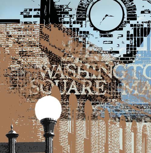
2 BUSINESS CORRIDOR REDEVELOPMENT PLAN
|
|
|
- Philippa Pope
- 5 years ago
- Views:
Transcription


1
2 2 BUSINESS CORRIDOR REDEVELOPMENT PLAN
3 ADOPTED DECEMBER 9, 2008 ACKNOWLEDGEMENTS 3 Acknowledgements Mayor Larry Buboltz City of Detroit Lakes Bob Louiseau, City Administrator Larry Remmen, Community Development Director Nancy Wichmann, Planning Department Secretary Detroit Lakes City Council Jim Anderson David Aune Matthew Brenk James Hannon Leonard Heltemes Bruce Imholte Walter Tollefson G.L. Tucker Ron Zeman Detroit Lakes Development Authority Jim Anderson, President Matthew Brenk Mary Beth Gilsdorf Greg Hildenbrand Mark Hagen Tom Klyve Dennis Winskowski CONSULTANT TEAM RDG Planning & Design Martin Shukert, FAICP - Project Principal Cory Scott, AICP - Project Manager Ben Iwen Amy Haase, AICP Paul Hunt Christopher Stara Sonja Carter - Graphic Design & Cover Economics Research Associates David Stone Chris Brewer
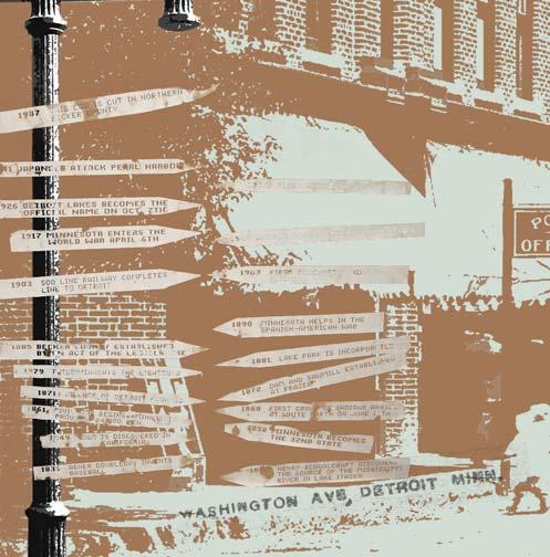
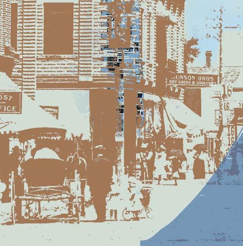
4 4 BUSINESS CORRIDOR REDEVELOPMENT PLAN Introduction In 1802 the earliest settlers to the area known today as Becker County were fur trappers and traders, collecting beaver pelts for sale to the east coast and European markets. This lead to the creation of new trading routes, the Red River Ox Cart and Old Red River Road trails developed between what is modern day Pembina, North Dakota and St. Paul, Minnesota. Along these routes, trading outposts would develop where local trappers could sell their furs and pick up provisions. One of these outposts, Tylerville, was a collection of buildings near the cabin of Mr. Merwin Tyler on the shores of Detroit Lake, where these two trails passed. Detroit Lakes, Minnesota was founded in 1871 as the Northern Pacific Railroad carved its way westward through Becker County towards the Pacific Ocean. Founded by Colonel George Johnston, the city s location was chosen for its location on the Red River Ox Cart and Old Red River Road trails. By 1873 with the aid of the railroad and these trails, one of the first grain warehouses west of Duluth was built. As the community continued to grow south of the tracks towards Detroit Lake other industries began to develop. Including the Fargo-Detroit Ice Company the first large-scale firm in the city, which provided ice to the Northern Pacific Railroad, and advertised their ice and spring water as practically pure of organic matter. Besides ice harvesting in its earliest days Detroit Lakes was also home to other industries including timber and furniture manufacturing. Since 1881 Detroit Lakes has been a tourist destination for individuals throughout the upper Midwest, given its woodlands and proximity to more than 400 lakes within 25 miles. City founders in order to capitalize on this market, created wide avenues leading towards Detroit Lake. While the apex of rail has passed, Detroit Lakes is still serviced by Amtrak s Empire Builder Line. Starting in the 1920s three major highways were constructed through Detroit Lakes, Minnesota State Highway 34 (1920), US Highway 10 (1926), and US Highway 59 (1934). These highways directly link the Twin Cities, Duluth and the Fargo/Moorhead metropolitan areas, and have helped to keep Detroit Lakes industrial economy alive. Detroit Lakes became a popular resort destination throughout the 1900s and as a community where both industry and families choose to call home. Restaurants, shops, beach are all popular destinations for vacationers. Soo Pass Ranch hosts some of the area s most popular events including WeFest and 10,000 Lakes Festival. Detroit Lakes wants to continue to be a destination of choice. Changes throughout the decades have resulted by design and default. New opportunities present themselves in Detroit Lakes with the realignment of Highway 10 opening up land for new development, new uses developing along West Lake Drive, and major commercial development happening along the west edge of the city. Indeed, change is inevitable for Detroit Lakes and a vision for that change has been conceived.


5 TABLE OF CONTENTS 5 Table of Contents Introduction Chapter 1: Markets for Detroit Lakes Chapter 2: Existing Conditions Chapter 3: Strategic Planning Chapter 4: Development Master Plan Chapter 5: Implementing the Plan
6 6 BUSINESS CORRIDOR REDEVELOPMENT PLAN


7 MARKETS 7 1 Detroit Lakes Markets This chapter analyzes potential markets to establish a specific development program for the Business Corridor Redevelopment Plan. It reviews important demographic and market characteristics to guide planning for the future of the study area. It also considers population and demographic characteristics of the market area to quantify future development markets for commercial, office, and residential possibilities.


8 8 BUSINESS CORRIDOR REDEVELOPMENT PLAN TRADE AREA DEFINITION Detroit Lakes is regionally known as a quality community with a unique downtown and getaway to more than 400 lakes in the surrounding region, and has historically been a significant small regional market at the crossroads of Highways 10, 34 and 59. The process of defining Detroit Lakes market area is through a market segmentation process, defining three separate geographic areas that Detroit Lakes can draw from and its potential to capture retail dollars.t Map Map 1.3 illustrates different geographic trade areas for Detroit Lakes. Primary trade area is a three-mile trade radius from the intersection of Highway 10 and Washington Avenue. Residents of the city do a large amount of their shopping in Detroit Lakes and view the city as a place where some goods and services can be met. Secondary trade area includes an area roughly twentyfive mile out from Highway 10 and Washington Avenue and extends out to include surrounding communities, including Frazee, Pelican Rapids, and Perham. While residents of this area use Detroit Lakes retailers and service providers for their daily needs there is a significant pull to the larger markets of Moorhead/Fargo, Fergus Falls, Brainerd, and Bemidji. The boundary of the market area uses a gravity model, considering the distance and population size of similar sized communities in the region and the probability that a person may select one community over the other to purchase goods and services. Tertiary trade area is more broadly defined and includes people who visit Detroit Lakes for special events, tourism or destination businesses. In addition, special attractions or places in a downtown district extend the effective size of the local market area. This area extends generally 90-miles from Detroit Lakes to include Park Rapids, Bemidji, Brainerd, and Fargo/Moorhead. The primary and secondary trade areas create the largest demand for goods and services in the city, and represent the basis for calculating commercial demand. Map 1.1, Map 1.2, Map 1.3: Geographic Trade Areas
9 MARKETS 9 DEMOGRAPHICS Population & Household Change Table 1.1 displays the historical population growth since Detroit Lakes has continued to see growth in the first six years of the decade at a somewhat greater rate than experienced in the 1990s. Table 1.2 compares Detroit Lakes with regional communities outside of Detroit Lakes. Of those communities, Detroit Lakes grew by 9.4% between 2000 and Compared with other communities in the region, Detroit Lakes has continued to experience substantial growth during this period. While during the same period, several other communities growth has slowed, after experiencing significant growth during the 1990s. Table 1.1: Historical Population Change, Detroit Lakes Year Population Decennial Change ,797 5,797 Decennial % Change Average Annual Rate of Change ,106 1, % 2.3% , % -0.7% , % 1.1% 2006 Est. 8, % 1.6% Source: U.S. Census Bureau The local and regional growth occurring around Detroit Lakes results in a growing economic base for the city and conversely the downtown. The majority of surrounding communities experienced population growth with the exception of Pelican Rapids and Wadena. Population Projection Table 1.3 considers the predicted and actual age cohort change for Detroit Lakes between 1990 and Based only on birth and death rates Detroit Lakes should have lost population during the 1990s but the city was able to attract new residents at a greater rate resulting in an overall population increase However, there is a loss in population occurring in the and age groups and an increase in the median age from 38.7 to The out-migration of residents in their child bearing years and an aging community results in fewer births and natural population loss. Table 1.4 identifies population growth trends from the 1990s for Detroit Lakes and three trade areas. Analysis of historic growth trends is one way to project future population growth for the city and region beyond All trade areas are expected to continue growing. At the rate of growth experienced in the 1990s, the number of residents living in the secondary trade area (excludes people in primary area) will increase by almost 10%, while the amount of residents living in the tertiary trade area will increase by 7%. Table 1.2: Population Change, Detroit Lakes & Area Communities Population 2000 Population Change % Change 2006 est. Population* Change % Change Detroit Lakes 6,635 7, % 8, % Alexandria 7,838 8, % 10,852 2, % Bemidji 11,245 11, % 13,291 1, % Brainerd 12,353 13, % 13, % Fergus Falls 12,362 13,471 1, % 13, % Park Rapids 2,863 3, % 3, % Pelican Rapids 1,886 2, % 2, % Perham 2,075 2, % 2, % Wadena 4,131 4, % 4, % Fargo-Moorhead, ND-MN 21, ,477 21, % miles* 41,939 46,940 5, % 49,337 2, % 90-miles* 528, ,592 56, % 613,744 28, % Source: U.S. Census Bureau, *2007 estimates provided by Claritas, Inc. for 25-mile and 90-mile
10 10 BUSINESS CORRIDOR REDEVELOPMENT PLAN Table 1.5 considers a number of potential growth scenarios for Detroit Lakes. Since 1970 the city has grown by about 0.79% annually. U.S. Census population projections between 2000 and 2006 suggest a growth rate of 1.5%. Building construction data, which is discussed later in this chapter, indicates growth has been occurring at about 1.39% annually. The tightening of the credit markets in 2008 make a more conservative approach more likely. If the city can maintain the building activity of the past seven years, about 45 units annually its growth rate will slow slightly to 1.1% annually. This is a healthy rate of growth and is slightly higher than that experienced during the 1990s. For planning purposes a ten year projection of 9,156 (2018) will be used. Income Characteristics Table 1.6 presents the 2007 estimated median household income for residents of Detroit Lakes, the primary area, the secondary area (including the primary market), and tertiary area. The secondary and tertiary areas have higher median incomes than what is seen in Detroit Lakes. The primary area has a much higher median household income than the other markets, indicating that some of the highest incomes in the region are in the area surrounding Detroit Lakes. The rate at which each area s median income is growing is comparable with the exception of the primary area, which has seen the greatest growth. Table 1.3: Predicted and Actual Age Cohort Change Age Group 1990 Actual 2000 Predicted 2000 Actual Actual minus Predicted % variance (Actual/ Predicted) Under % % % % % % % % % % % % % % % % % % Total 6,635 6,325 7, % Median Age Source: U.S. Census Bureau Table 1.4: Projected Population , Market Areas 1990 Population 2000 Population Table 1.5: Migration and Growth Scenarios for Detroit Lakes Growth rate bw 1990/2000 % Change 1990/ Natural Population Change 7,348 7,078 6,992 6,912 6,864 6, % Annual Growth Rate(Historic 30-year rate) 7,348 7,764 8,005 8,467 8,997 9, % Annual Growth Rate (Construction b/w 00-07) 7,348 8,094 8,444 9,052 9,703 10, % Annual Growth Rate 8,094 8,392 8,863 9,361 9,881 Table 1.6: Median Income Forecasts in Detroit Lakes Market Areas, Estimate 2012 Estimate % Change 2000/2012 Detroit Lakes 6,635 7, % 10.75% 8,094 8, % Primary (3-mile) 8,650 8, % 1.80% 8,983 9, % Secondary (25-mile) 41,939 46, % 11.92% 49,337 50, % Secondary-Primary 33,289 38, % 14.55% 40,354 41, % Tertiary (90-mile) 528, , % 10.72% 613, , % Tertiary-Secondary 486, , % 10.62% 564, , % Source: U.S. Census Bureau, Claritas, Inc. Source: U.S. Census Bureau, Claritas, Inc., RDG Planning & Design Est. Change % Change Detroit Lakes $29,264 $34,340 $5,076 17% Primary (3-mile) $30,778 $47,495 $16,717 54% Secondary (25-mile) $35,771 $43,325 $7,554 21% Tertiary (90-mile) $36,351 $43,767 $7,416 20% Source: Claritas, Inc., U.S. Census Bureau
11 MARKETS 11 Table 1.7: Work Places and Employment for Detroit Lakes Downtown Trade Areas Business Description Total Establishments % Primary Trade Area Total Employed % Total Establishments % Secondary Trade Area Total Employed Industries (All) % 12, % 2, % 29, % Agriculture (All) 21 2% 241 2% 117 4% 707 2% Mining (All) 0 0% 0 0% 1 0% 7 0% Construction (All) 62 7% 448 4% % 1,531 5% Manufacturing (All) 46 5% 1,684 14% 128 4% 4,078 14% Transportation, Communications/Public Utilities 47 5% 391 3% 148 5% 1,663 6% Wholesale Trade (All) 29 3% 245 2% 92 3% 738 2% Retail (All Retail) % 2,541 21% % 4,822 16% Finance (All) 97 11% 765 6% 240 8% 1,395 5% Service (All) % 4,712 38% 1,144 40% 12,657 42% Public Administration (All) 79 9% 1,312 11% 165 6% 2,203 7% % Source: Claritas, Inc. Table 1.8 Index of Per capita Expenditures for Selected Products, 2007 Product Type Primary Secondary Tertiary Total Apparel Sports and Recreation TV, Radio and Sound Equipment Reading Materials Travel Photographic Equipment Total Food at Home Total Health Care Total Household Textiles Total Furniture Major Appliances Small Appliance/Houseware Misc Household Equipment Personal Care Products and Services Personal Expenses and Services Smoking Prods/Supplies Total Education Room and Board Tuition/School Supplies Pet Expenses Day Care Housekeeping Supplies Total Food away from Home Total Alcoholic Beverages Alcoholic Beverages at Home Alcoholic Beverages away from Home Household Services Household Repairs Total Housing Expenses Fuels and Utilities Telephone Service Total Transportation Expenses Automotive Maintenance/Repair/Other Source: Claritas, Inc. Workplace & Employment for Detroit Lakes Table 1.7 indicates the different types of businesses and number of individuals employed in each within the primary and secondary trade areas. In the primary area the three largest employment bases are in service, retail, and manufacturing, which accounts for 73% of all employment. Within the secondary area the largest employment base is service-oriented with 42%. Retail and manufacturing follow with 16% and 14%, respectively. PROJECTED ANNUAL EXPENDITURE GROWTH Consumer Spending Patterns by Product Table 1.8 compares annual consumer expenditures by product type in each trade area to the national average. National average per capita expenditures are equal to a market index of one hundred, which is the ratio of the Annual Average Household Expenditure (AAHE) in each trade area compared to the AAHE for the United States. Therefore, scores greater than 100 indicates that consumers spend more on a good or service than the rest of the nation. With the exception of reading materials and smoking products/supplies, consumers in the Detroit Lakes primary trade areas spend slightly less on most consumable goods and services than consumers nationwide. Consumers in the secondary area spend close to the national average in most consumable goods, although there are categories where expenditures are greater, specifically on smoking products, reading materials, health care, household equipment, pet expenses and transportation costs. Expenditures in the tertiary market exceeding the national average include smoking products, reading supplies, and transportation costs.
 is to consider its share of total regional retail sales. Table 1.")

12 12 BUSINESS CORRIDOR REDEVELOPMENT PLAN The number of categories in the secondary area that exceed the national index of 100 is greater than the number of categories in the primary or tertiary market areas. Retail Sales One way of evaluating Detroit Lakes retail role in the secondary area (25-miles) is to consider its share of total regional retail sales. Table 1.9 indicates total retail sales in the primary and the secondary market area. In 2007, the primary market reported $301,407,523 in retail sales, while the secondary market reported slightly more at $355,133,983. The secondary market includes a substantially larger area than the primary market. Of the total $656,541,506 retail dollars spent in the combined primary and secondary areas, nearly 46% of retail sales within the 25-mile area were reported in and around the immediate vicinity of Detroit Lakes. Retail Sales Gap Analysis for Detroit Lakes Detroit Lakes attracts substantial spending from outside of the community. Within Detroit Lakes primary market, retail sales were reportedly $301,407,523 in Detroit Lakes current population generates a demand of $144,585,861. The difference is $156,821,662 that is coming from outside of the community to the immediate area of Detroit Lakes. In other words, people from outlying areas are traveling to Detroit Lakes to spend their money, giving the city a highly positive balance of trade. Table 1.10 identifies the gap between consumer demand (expenditures) and retail sales within each of the community s trade areas. A positive value results from demand exceeding supply and reflects a leakage of consumer dollars. In other words, residents have dollars to spend but they are spending them outside of their market area, which is evident in the secondary market. A negative value results from sales exceeding demand and indicates a flow of regional dollars into the city s retail market, which is evident in the primary market. In Detroit Lakes, 2007 retail supply exceeded demand within the primary market by nearly $150 million, illustrating the community s ability to attract retail dollars from a large surrounding region. Table 1.9: Share of Total Retail Sales, 2007 (exclusive) Total Retail Sales % of Total Primary (3-mile) $301,407,523 46% Secondary (25-mile) $355,133,983 54% Total $656,541, % Source: Claritas, Inc. As downtowns across the nation compete for a share of the retail market, many have found success in specialty or niche markets. Downtowns that compete successfully against big box retailers have focused on service oriented and specialty retailing. Specific market sectors that appear to hold potential for Downtown Detroit Lakes include: Specialty Retail Furniture and Home Furnishings (specialty or general) Pharmacy or Drug Store Office Supplies Food Service & Drinking Establishments Note: Table 1.10 displays the difference between demand (Consumer Expenditure Survey from the U.S. Bureau of Labor Statistics) and supply (Census of Retail Trade from the U.S. Census Bureau). Numbers in parenthesis reflect a greater supply than demand, while numbers without parenthesis reflect a greater demand than supply. Total retail sales in Detroit Lakes were $301,407,523 (Table 1.7), while demand for goods and services was $144,585,861 for a difference of $156,821,662). This represents a greater supply than demand.
13 MARKETS 13 Table 1.10: Primary Market Area s Demand, Supply and Opportunity Gap, Demand Consumer Expenditures 2007 Supply Retail Sales Opportunity Gap Surplus/ Shortage Total Retail Sales Including Eating and Drinking Places 144,585, , (156,821,662) Motor Vehicle and Parts Dealers 28,320,959 99,637,819 (71,316,860) Automotive Dealers 24,524,404 86,393,801 (61,869,397) Other Motor Vehicle Dealers 1,579,822 9,117,020 (7,537,198) Auto Parts/Accessories, Tire Stores 2,216,733 4,126,998 (1,910,265) Furniture and Home Furnishings Stores 3,712,243 3,114, ,703 Furniture Stores 1,964,507 2,846,622 (882,115) Home Furnishing Stores 1,747, ,918 1,479,818 Electronics and Appliances Stores 3,260,171 3,771,473 (511,302) Appliances, Televisions, Electronics Stores 2,539,553 3,742,614 (1,203,061) Computer and Software Stores 593,964 28, ,105 Camera and Photographic Equipment Stores 126, ,653 Building Material and Garden Equipment Stores 16,610,394 25,818,549 (9,208,155) Building Material and Supply Dealers 15,107,921 25,558,161 (10,450,240) Lawn/Garden Equipment, Supplies Stores 1,502, ,388 1,242,085 Food and Beverage Stores 17,397,151 26,612,429 (9,215,278) Grocery Stores 15,730,507 21,850,123 (6,119,616) Specialty Food Stores 505,476 1,161,174 (655,698) Beer, Wine and Liquor Stores 1,161,169 3,601,132 (2,439,963) Health and Personal Care Stores 8,429,120 5,178,768 3,250,352 Pharmacies and Drug Stores 7,259,649 4,340,495 2,919,154 Cosmetics, Beauty Supplies, Perfume Stores 308,376 18, ,518 Optical Goods Stores 313, ,414 (81,463) Other Health and Personal Care Stores 547, , ,143 Gasoline Stations 16,134,981 44,225,154 (28,090,173) Clothing & Clothing Accessories Stores 5,436,816 5,577,275 (140,459) Clothing Stores 3,893,375 4,252,270 (358,895) Shoe Stores 773, , ,731 Jewelry, Luggage, Leather Goods Stores 769, ,998 (159,295) Sporting Goods, Hobby, Book, Music Stores 2,499,367 2,398, ,764 Sporting Goods, Hobby, Musical Instrument Stores 1,742,588 2,091,979 (349,391) Book, Periodical and Music Stores 756, , ,155 General Merchandise Stores 16,714,940 59,105,280 (42,390,340) Department Stores Excluding Leased Departments 7,530,065 38,320,805 (30,790,740) Other General Merchandise Stores 9,184,876 20,784,475 (11,599,599) Miscellaneous Store Retailers 3,962,778 2,308,245 1,654,533 Florists 278, ,228 9,657 Office Supplies, Stationery, Gift Stores 1,564, ,644 1,081,803 Used Merchandise Stores 303, , ,312 Other Miscellaneous Store Retailers 1,815,447 1,412, ,761 Non-Store Retailers 8,657,873 4,719,862 3,938,011 Foodservice and Drinking Places 13,449,067 18,939,526 (5,490,459) Full-Service Restaurants 6,127,774 8,041,813 (1,914,039) Limited Service Eating Places 5,612,847 10,016,510 (4,403,663) Special Foodservices 1,084, , ,321 Drinking Places Alcoholic Beverages 624, , ,923 GAFO* 33,187,984 74,449,815 (41,261,831) General Merchandise Stores 16,714,940 59,105,280 (42,390,340) Clothing and Clothing Accessories Stores 5,436,816 5,577,275 (140,459) Furniture and Home Furnishings Stores 3,712,243 3,114, ,703 Electronics and Appliance Stores 3,260,171 3,771,473 (511,302) Sporting Goods, Hobby, Book, Music Stores 2,499,367 2,398, ,764 Office Supplies, Stationery, Gift Stores 1,564, ,644 1,081,803 Source: Claritas, Inc.

 can be calculated.")

14 14 BUSINESS CORRIDOR REDEVELOPMENT PLAN RETAIL SPACE POTENTIAL Projecting the growth of retail expenditures helps determine the need for additional retail space in Detroit Lakes. Overall, Detroit Lakes is an importer of retail dollars but, as identified in Table 1.11, there are specific niche markets that the community can further develop. Downtown is less likely to be in direct competition with big box retailers like Wal-Mart. By using the data in Table 1.9, current per capita spending can be determined. If the amount of dollars spent per individual is applied to Detroit Lakes future population and that of its regional market, future retails sales (based on 2007 dollar) can be calculated. These market areas should continue to capture projected retail sales at current rates but should also strive to capture a portion of the dollars that leak to other market areas. Note: The numbers in the primary market column in this table match the opportunity/gap in Table 1.10 Tables 1.12 and 1.13 illustrate this methodology and relate future expenditures to retail space demands. This is determined by: Calculating the average sales yield of retail space in Detroit Lakes, using an estimated sales yield of $250 per square foot. This figure is provided by Urban Land Institute s (ULI) Dollars and Cents of Shopping Centers, Assuming the downtown s share of the entire city s retail sales, and therefore square footage, is 30%. This is slightly lower than the downtown s share of total retail square footage; however, this analysis was focused on niche areas that would more likely be drawn to a downtown market. The analysis indicates a potential demand for an additional 65,000 square feet of retail space in the downtown over the next five years. The Downtown currently has 57,513 square feet of vacant first and second story space. Although this appears to be an adequate to meet future demands For comparison, Central Market has about 60,000 square feet. The result of relocating Highway 10 opens up land for redevelopment. This land could be used for new commercial development, strengthening the fringe of the traditional Main Street and expanding downtown commercial uses.
15 MARKETS 15 Table 1.11: Opportunity Gap Analysis for Detroit Lakes Market Areas Opportunity Gap Surplus/ Shortage Opportunity Gap Surplus/ Shortage Opportunity Gap Surplus/ Shortage Total Retail Sales Including Eating and Drinking Places (156,821,662) 172,272,083 ($521,869,480) Motor Vehicle and Parts Dealers (71,316,860) 17,162,481 $114,015,352 Automotive Dealers (61,869,397) 32,290,507 $220,957,539 Other Motor Vehicle Dealers (7,537,198) (18,885,164) ($104,955,709) Auto Parts/Accessories, Tire Stores (1,910,265) 3,757,139 ($1,986,474) Furniture and Home Furnishings Stores 597,703 9,410,639 $72,575,872 Furniture Stores (882,115) 840,408 $42,858,722 Home Furnishing Stores 1,479,818 8,570,231 $29,717,150 Electronics and Appliances Stores (511,302) 11,615,786 ($3,544,076) Appliances, Televisions, Electronics Stores (1,203,061) 7,550,667 ($19,287,579) Computer and Software Stores 565,105 3,335,033 $14,426,038 Camera and Photographic Equipment Stores 126, ,086 $1,317,465 Building Material and Garden Equipment Stores (9,208,155) 20,132,799 ($314,040,102) Building Material and Supply Dealers (10,450,240) 46,442,022 $17,082,440 Lawn/Garden Equipment, Supplies Stores 1,242,085 (26,309,221) ($331,122,541) Food and Beverage Stores (9,215,278) 23,740,825 ($51,471,388) Grocery Stores (6,119,616) 33,723,703 $40,721,133 Specialty Food Stores (655,698) (303,670) $659,279 Beer, Wine and Liquor Stores (2,439,963) (9,679,209) ($92,851,796) Health and Personal Care Stores 3,250,352 25,294,622 $155,521,778 Pharmacies and Drug Stores 2,919,154 20,092,415 $129,550,939 Cosmetics, Beauty Supplies, Perfume Stores 289,518 1,554,523 $12,421,674 Optical Goods Stores (81,463) 1,271,178 $9,413,672 Other Health and Personal Care Stores 123,143 2,376,507 $4,135,494 Gasoline Stations (28,090,173) (15,422,271) ($486,783,705) Clothing & Clothing Accessories Stores (140,459) 19,505,393 $167,110,871 Clothing Stores (358,895) 14,618,672 $116,238,155 Shoe Stores 377,731 1,917,573 $31,474,085 Jewelry, Luggage, Leather Goods Stores (159,295) 2,969,148 $19,398,630 Sporting Goods, Hobby, Book, Music Stores 100,764 7,245,241 ($9,277,088) Sporting Goods, Hobby, Musical Instrument Stores (349,391) 3,604,298 ($40,069,636) Book, Periodical and Music Stores 450,155 3,640,943 $30,792,547 General Merchandise Stores (42,390,340) (12,609,499) ($424,451,167) Department Stores Excluding Leased Departments (30,790,740) (16,759,752) ($468,337,066) Other General Merchandise Stores (11,599,599) 4,150,253 $43,885,899 Miscellaneous Store Retailers 1,654,533 9,452,182 $29,738,821 Florists 9, ,602 ($3,738,610) Office Supplies, Stationery, Gift Stores 1,081,803 6,527,491 $22,464,761 Used Merchandise Stores 160,312 1,157,962 ($913,409) Other Miscellaneous Store Retailers 402,761 1,055,126 $11,926,080 Non-Store Retailers 3,938,011 34,227,702 $69,432,325 Foodservice and Drinking Places (5,490,459) 22,516,182 $159,303,010 Full-Service Restaurants (1,914,039) 9,670,018 $41,750,567 Limited Service Eating Places (4,403,663) 10,502,052 $120,635,716 Special Foodservices 417,321 3,019,408 $36,388,325 Drinking Places Alcoholic Beverages 409,923 (675,296) ($39,471,597) GAFO* (41,261,831) 41,695,051 ($175,120,829) General Merchandise Stores (42,390,340) (12,609,499) ($424,451,167) Clothing and Clothing Accessories Stores (140,459) 19,505,393 $167,110,871 Furniture and Home Furnishings Stores 597,703 9,410,639 $72,575,872 Electronics and Appliance Stores (511,302) 11,615,786 ($3,544,076) Sporting Goods, Hobby, Book, Music Stores 100,764 7,245,241 ($9,277,088) Office Supplies, Stationery, Gift Stores 1,081,803 6,527,491 $22,464,761 Source: Claritas, Inc.
16 16 BUSINESS CORRIDOR REDEVELOPMENT PLAN OFFICE MARKET POTENTIAL Detroit Lakes has about 105,993 square feet of downtown office space, or square feet per capita in Based on projected population growth by 2012, there will be a demand for an additional 6,300 square feet of new space. Doubling this hard demand to account for new enterprises suggests a development demand for about 12,600 square feet of multi-tenant space. Other forces affect office demand. For example, business diversification and expansion can generate a demand for new space. Individual companies may decide to build space for themselves in a resurgent central area, and new demands may occur, such as medical offices. On the other hand, downsizing can put other space on the market. The overall plan should accommodate these possibilities. HOUSING MARKET POTENTIAL Residential development has been critical to downtown revitalization initiatives in many communities and could play a role in the growth and sustainment of Downtown Detroit Lakes. This section addresses potential housing markets in the district. Recent Construction Activity Table 1.14 displays residential construction activity within the city between 2000 and The rate of construction varied year to year, with as many as 58 housing units added in 2005 and as few as 20 added in On average, approximately 41 homes were built annually. Currently, the downtown housing mix includes upper level renter occupied units and some single-family and mobile home units on the periphery of the downtown. Overall the downtown lacks high quality residential options. In the future, housing opportunities located near or in the downtown district will most likely continue to be alternative forms such as senior living, town homes, and attached housing. Table 1.12 Potential Demand for Retail Space in Downtown Detroit Lakes 2012 (auto withheld) Primary Secondary Tertiary Total 2007 Estimated Demand $ 116,264,902 $ 515,010,072 $7,235,045,743 $7,866,320, Estimated Population 9,571 40, , , Per Capita Dollars $ 12,148 $12,762 $12,819 $12, Projected Population 10,076 41,788 $579, , Projected Demand $122,399,452 $533,311,218 $7,429,648,626 8,085,536,728 Increment $6,134,550 $18,301,146 $194,602,883 $219,216,011 Capture Rate 100% 79% % Citywide Share of the Increment $6,134,550 $14,497,183 $194,602, ,234,615 Existing Gap - $311,931, ,931,264 Future Gap - $3,803,963-3,981,396 Total Gap - $315,735, ,912,660 Capture Rate (current) 100% 10% 1.10% Share of Gap - $31,573,523-31,573,523 Total Increment $6,134,549 $46,070,705 $2,140,632 54,345,887 Sales Yield Per Square Foot $250 $250 $250 $250 Citywide commercial Space Demand (SF) 6, ,283 8, ,384 Source: Claritas, Inc., RDG Planning & Design, Urban Land Institute Table 1.13: Potential Demand for Retail Space, Downtown Detroit Lakes Primary Secondary Tertiary Total Increase in Retail Sales $6,134,549 46,070,705 2,140,632 54,345,887 Sales Per Square Foot $250 $250 $250 $250 Total Commercial Square Footage 24, ,283 8, ,384 Downtown Share 30% 30% 30% 30% Total Share for Downtown 7,361 55,285 2,559 66,215 Source: RDG Planning & Design, Urban Land Institute
17 MARKETS 17 Overall Housing Demand Based on population forecasts developed in Table 1.5 and Table 1.14 projects housing development in Detroit Lakes to The housing demand model assumes that: Over the last several years the vacancy rate and people per household have remained steady; however, over the next ten years the vacancy rate will decline and as the children of baby-boomers begin having families the number of people per household will once again increase. Four units will be removed from the market on an annual basis due to demolition or conversion to another use. Detroit Lakes generates a 10-year demand for about 479 new housing units, or about 48 units annually. Typically, a central district area can absorb about 10-15% of this demand. Providing a variety of housing will be essential to increasing demand and meeting future city projections. This should include housing options in and around the downtown. Retail Impact of Downtown Housing Downtown Detroit Lakes can grow as a residential neighborhood. Assuming that the downtown captures 10-15% of the city s housing market the central district supports annual production of about 5-7 units. According to the 2000 Census, the overall occupancy mix in the city is roughly 70% owneroccupied and 30% renter occupied. Table 1.15 projects a tenyear downtown housing development program based on these assumptions. Effectively developed, downtown housing can be a unique attraction, and can often develop its own, larger market. An overall revitalization program that makes downtown more attractive also increases housing demand. For example, a focus on the arts may generate a demand for live/work housings or development of senior housing can attract people from a broader area. Table 1.16 presents a downtown occupancy and pricing program, based on the current income distribution and owner/ renter occupancy split in Detroit Lakes. Actual production may differ from these projections because of market or lifestyle preferences, such as the desire of higher-income residents or urban pioneers to live in higher-cost housing. Nevertheless, this program can guide the city and potential developers. Development trends suggest lakefront sites, such as those along West Lake Drive, may attract more than this share of the market. This is not a recommendation, but a trend being experienced in Detroit Lakes. Additional downtown housing development also can influence demand for retail goods and services. Based on Consumer Spending data (utilized in Table 1.8), per capita annual spending for retail goods and services within Detroit Lakes is estimated at $12,148. An additional units over ten years at 2.2 people per household would result in new residents, or an annual spending level increase in 2007 dollars of $1.3 million to $2 million. Assuming that the downtown continues to capture 43% of local expenditures, this downtown Table 1.14: Detroit Lakes Residential Construction Activity Type Total Units People/ HH Total People SF Units MF Units Total Source: City of Detroit Lakes, U.S. Census Bureau Table 1.15: Projected Housing Development Demand to 2018 Detroit Lakes 2008 (Base) Total 1.4% Annual Growth Rate Population at the End of Period 8,207 8,668 9,156 Household Population at End of Period 7,904 8,349 8,818 People/Household Household Demand at End of Period 3,558 3,749 3,947 Projected Vacancy Rate 11.9% 11.9% 11.9% Total Unit Needs at End of Period 4,039 4,255 4,480 Available from Previous Year 4,212 4,435 Lost Units Annual Need Cumulative Need Source: RDG Planning & Design
18 18 BUSINESS CORRIDOR REDEVELOPMENT PLAN Table 1.16 Projected Housing Demand, Table 1.17: Housing Development Program residential market could generate about $553,700 to $825,300 of additional consumer spending in the district. Based on an average retail yield of $250 per square foot, the potential downtown residential market could support approximately 2,200 to 3,300 square feet of additional retail space. CONCLUSIONS Total Owner-Occupied Units 49 Renter Occupied Units 23 Total 72 Source: RDG Planning & Design, U.S. Census Bureau Total Total Need 72 Total Owner Occupied 50 Affordable Low: , Affordable Moderate: , Moderate Market: , Higher Market: Over $200, Total Renter Occupied 21 Low: Less than $400 9 Affordable: $ Market: Over $800 6 Source: RDG Planning & Design, U.S. Bureau of the Census, Claritas, Inc. This analysis of population and potential markets leads to the following conclusions: Detroit Lakes and the surrounding region have experienced consistent population increases since the 1990s and are expected to continue growing. The strong growth of the secondary market outside of Detroit Lakes indicates an increasing number of regional residents that will most likely look to Detroit Lakes for retail goods and services. If the City of Detroit Lakes is able to maintain the growth it has experienced in the last seven years, its 2020 population will be approximately 9,360. Retail sales in Detroit Lakes exceed consumer expenditures, which reinforces the community s ability to serve local residents as well as populations in the secondary and tertiary trade areas. As the regional population continues to grow, demand for retail goods and services in Detroit Lakes will also increase. Recent retail expansion within Detroit Lakes will likely drive the downtown to focus on specialty markets that are traditional to downtown markets. While Detroit Lakes as a whole is an importer of retail dollars, this has not been the case for the niche markets. New development sites created as a result of Highway 10 relocating will create opportunities to attract conventional development patterns. Within the secondary market area ring, Detroit Lakes (primary market) has 46% of the total retail sales, while the area outside Detroit Lakes (secondary market) makes up the remaining 54%. Consumer spending patterns in the primary market are slightly lower than the national trend. However, spending patterns in the secondary market are slightly higher than the primary or tertiary markets. Over the next 5 years, Detroit Lakes as a whole could absorb 217,000 square feet of additional niche commercial space. The downtown could absorb 30% or 65,000 square feet of additional large market commercial space. Detroit Lakes primary market has 1,205,600 square feet of consumer-oriented retail/service space. An increase of 5% of sales ($12.50 SF) adds $15 million in retail sales and adds $30 million to the local economy (or $3,300 for each full time resident). Detroit Lakes has 556,291 square feet of consumer oriented retail/service space in downtown alone. An increase of 5% of sales ($12.50 SF) adds $6.95 million in retail sales and adds $13.9 million to the local economy (or $1,600 for each resident). Downtown could capture up to 10-15% of the city s housing production or 5-7 units annually. Office development in Detroit Lakes is experiencing a demand for 12,600 square feet by Offices located on the main floor of buildings could otherwise be used for commercial uses. Additional downtown housing development can influence demand for retail goods and services. An additional 48 to 72 units over ten years could result in 198 new residents, or an annual spending level increase in 2007 dollars of $2.5 million. Assuming that the Downtown continues to capture 43% of local expenditures, this downtown residential market could generate up to about $1.1 million of additional consumer spending in the district. This potential downtown residential market could support approximately 4,400 square feet of additional retail space.


19 EXISTING CONDITIONS 19 2 Existing Conditions This chapter examines existing conditions and opportunities in the business corridors in Detroit Lakes. It provides a basis for planning future development.
20 20 BUSINESS CORRIDOR REDEVELOPMENT PLAN Structure of the Business Corridor Detroit Lakes was named after the narrow sandbar strait within the Lake that a French Catholic Priest commented on while encamped on the banks of the lake. The word Lakes was added in 1926 to distinguish the city from Detroit, Michigan. Originally, Detroit Lakes was laid out on a grid pattern with major corridors forming along a north-south access perpendicular to the railroad. Downtown Detroit Lakes developed at the northern end of Washington Avenue near the railroad depot. The buildings of this district were built to the property lines, largely in the early years of the twentieth century. Designed as a broad street for turning wagons around, Washington Avenue was originally the primary view corridor and route between the rail depot, downtown, and the lake. The advent of the automobile changed the structure of downtown and Washington Ave. As a result, people relied less on trains for transportation. By the 1940s three major highways intersected at Detroit Lakes, Highways 10, 59, and 34. The development of Highway 10 in the 1920s, lead to major alterations in the shape and character of downtown Detroit Lakes. The greatest effects were seen on the eastern side of downtown where Highway 10 cuts across three city blocks. The structure of the city was altered by these routes, changing it from a pedestrian-oriented place to one oriented towards the automobile. This pattern became more pronounced in the late-1900s, spreading commercial uses out from the traditional core to the edges of the city. Nonetheless, Washington Avenue today continues as a leading destination for shopping in the city and region. In 2006, the Minnesota Department of Transportation, in partnership with the City of Detroit Lakes and the Burlington Northern Santa Fe Railroad, began relocating Highway 10. The relocation of this highway changes accessibility to businesses and vacates about five acres of land. The area of downtown and its surrounding area have a distinguishable pattern of development that can be described in several sub-districts, including: Downtown Core The Crescent Community Center Connection St. Mary s District Railroad North Washington South Washington Lake District Downtown Core. This area includes Washington Avenue from Highway 10 to Frazee Street. The buildings fronting this street range from one to three stories, built to the property line with awnings extending from the face of the building. The area is characterized by a large number of businesses along Washington Avenue with parallel parking. Additional parking is located on side streets and parking lots behind buildings. This is also the retail heart of the community and has experienced significant reinvestment. Gateway District. The relocation of Highway 10 creates a significant amount of land on the edge of Highway 10. Existing uses are characterized by individual buildings separated from one another with minimal landscaping. Concrete and asphalt parking lots in front of these structures dominate the entrances into these developments. Numerous buildings along Highway 10 are noticeably underutilized and possibly vacant. Industrial uses along with their condition influences the perception of the corridor, downtown, and the city. A Gateway District Master Plan was developed prior to the relocation of Highway 10 to guide development in this district. Chapter 4 of this document refers to the Gateway District as The Crescent. Community Center Connection. As a center for community based services, the Detroit Lakes Community and Cultural Center on Summit Avenue is at the heart of the district. Surrounding civic uses strengthen the civic nature. Many of the social and cultural events for the community are in close proximity of this facility, including the Becker County Museum, fire department and the historic Holmes Theatre. In addition, the district is also home to several of Detroit Lakes congregations which are located along Lake Avenue. St. Mary s District. Located at the crossroads of Washington Avenue and Frazee Street, St. Mary s Regional Health Center is a medical community. Services and facilities include a hospital, nursing center, senior apartments, home health care, and ambulance services. Currently, plans are underway for the expansion and renovation of current facilities in order to ensure St. Mary s ability to continue to serve the community of Detroit Lakes well into the future. Railroad. As part of the realignment of Highway 10 through the Gateway District, the railroad was shifted adjusted for the project. These lines are currently owned and operated by the Burlington Northern Santa Fe (BNSF), and are the major artery for freight traffic between the Pacific Northwest and Eastern markets. According to the Minnesota Department of Transportation, 50 to 60 freight trains pass through on a daily basis. Passenger rail service is also provided at the Detroit Lakes Depot via Amtrak s Empire Builder, with inbound and outbound trains arriving during early morning hours.

21 EXISTING CONDITIONS 21 North Washington Community Center Connection Downtown Core The Crescent St. Mary s District South Washington Lake District

22 22 BUSINESS CORRIDOR REDEVELOPMENT PLAN North Washington. Limited commercial development is located immediately north of the railroad tracks then transitions to residential uses when approaching Highway 34. The Highway 34 intersection has vacant property on the southwest corner and commercial uses on the northside. South Washington. The corridor is the main link between the Downtown Core and Lake District. Churches, single-family and multi-family housing, offices and a ballpark all border this street. Lighting along for the two-lane street includes cobra head fixtures mounted to galvanized poles. Parallel parking is available on-street. Lake District. West Lake Drive offers drivers and pedestrians vistas of the lake along this tree-lined street. The City Beach and marina facilities are located on the lakeside of the street, while restaurants, lodging, retail and residential dwellings dominate the north side. Many properties along the corridor have been redeveloped for condominium housing overlooking the lake. The City Park, located along the lake at Washington Avenue and West Lake Drive, is the largest park in Detroit Lakes at 25 acres. The Pavilion located within the park has been a landmark for decades and available for people to rent for individual events. City Park also boasts a Frisbee golf course, physical fitness course, tennis courts and the city s bathhouse. Land and Building Use Table 2.1 summarizes building use in the business corridor study area. The overall district provides approximately 1,932,960 square feet of gross floor area, with about 1,122,405 square feet on street level and 466,697 additional square feet on upper levels. Street level space in the district has a low vacancy rate of about 3.6%, although some is in marginal use. The upper level spaces include a mixture of uses with most occupied spaces being used for housing. Among occupied commercial space users, consumer uses, including retailing, personal services, and hospitality, account for about 572,701 square feet, while private office uses occupy about 114,109 square feet. Medical services, including St. Mary s Regional Health Center, account for 343,858 square feet of space. Civic (churches and non-profits) and governmental institutions occupy over 402,789 square feet. Table 2.1: Building Use in Downtown Detroit Lakes Building Use Type Main Level (SF) Upper Level (SF) Total (SF) Upper Floor Residential - 47,087 47,087 Multi-Family Residential 40,660 61, ,160 Senior Living (multi-family) 59, , ,619 Hospitality 12,728 12,728 Office 144,109 42, ,917 Service 43,736 1,985 45,721 Automotive 54,260 54,260 Retail 376,352 9, ,388 Restaurant/Entertainment 72,104 2,500 74,604 School 12,400 12,400 Other Civic Uses 162,850 97, ,300 Light Industrial 29,034 29,034 General Industrial 10,000 10,000 Medical Services 168, , ,858 Public Facility 92,964 37, ,089 Vacant Space 11,282 57,513 68,795 Total 1,122, ,697 1,932,960 Source: Community Growth Institute, 2008; RDG Planning & Design, 2008 The remaining square footage is associated with the light industrial uses. The Building Use Map (Map 2.1) indicates the geographic distribution of these uses in the district.

23 EXISTING CONDITIONS 23 Map 2.1: Building Use, Main Level Source: Community Growth Institute, 2008; RDG Planning & Design, 2008

24 24 BUSINESS CORRIDOR REDEVELOPMENT PLAN Historic Background This analysis identifies potential opportunities for redevelopment or adaptive reuse by relating building occupancy and historic significance. Detroit Lakes exhibits several examples of early Twentieth Century commercial architecture, although several buildings were lost to fires in 1910 and The goal setting process, discussed in Chapter Three, indicates that stakeholders in the District appreciate the traditional downtown ambiance, and that historic preservation is an important community value. The Graystone building, in particular, was noted as an example of a historic building that was rehabilitated for active uses. Strategies should preserve these valuable resources and maintain them in productive use. Federal incentives such as the Historic Tax Credit, the National Trust Main Street Program, and state programs encourage adaptive reuse of historic buildings. The Opportunity Analysis relates building utilization and historic significance. Historic assessment considers the report prepared by Gemini Research for Historic Cultural Resources Inventory of Historic Structures on Washington Avenue. This report was used as background to classify business in the following categories: Landmarks. These are buildings judged to be of essential historic significance and are either listed or eligible for individual listing on the National Register of Historic Places. Strongly Contributing Buildings. These individual structures contribute to the character or fabric of the National Register district. Some may also be eligible for individual listing. Background Contributing. These buildings were typically built before World War II and represent examples of vernacular commercial architecture. While probably not individually eligible for Register listing, they generally contribute to the character of their overall context through having similar construction materials and setback. Significant New Buildings. These are relatively contemporary buildings that represent substantial capital investments. Not Contributing. These are structures that do not contribute to the structure or fabric of a significant historic or design district. Negative. These are typically structures that detract from the fabric of a district because of deteriorating condition or appearance. Major Modification. These represent structures that have undergone major modifications and, as a result, do not contribute to the integrity of the district. Some of these buildings have been modified with a screen or façade treatment that may be reversible. The Opportunity Analysis relates the economics of building utilization and historic assessment to define potential targets for adaptive reuse. It places buildings in the following groups: Category 1, representing the highest priority potential opportunities for adaptive redevelopment. This category includes buildings that rank as landmarks or strongly contributing structures that are vacant on upper-levels or are warehouses in low use. These buildings represent major historic resources that may be threatened economically by low use. Category 2, represents buildings equal to Category 1 in significance, but which exhibit some upper level use. While high in priority, these buildings may not face the same economic threat as Category 1 structures. Category 3, including background contributing buildings with upper level vacancy. Loss of these buildings would result in gaps on streets. Category 4, including background contributing buildings with at least some upper-level occupancy. Again, these buildings may not face the economic pressures experienced by category 3 structures. Category 5, including structures with substantial vacancy that are either non-contributing, negative, or have experienced major modification. A project that restores a historic building to original appearance should be placed in Categories 1 or 2. This ranking of priorities can help the city identify potential reuse targets or consider competing projects.

25 EXISTING CONDITIONS 25 Map 2.2: Existing Building Use, Upper Stories Source: Community Growth Institute, 2008; RDG Planning & Design, 2008
26 26 BUSINESS CORRIDOR REDEVELOPMENT PLAN Map 2.3: Historical Significance Source: Community Growth Institute, 2008; RDG Planning & Design, 2008

27 EXISTING CONDITIONS 27 Map 2.4: Building Conditions Source: Community Growth Institute, 2008; RDG Planning & Design, 2008


28 28 BUSINESS CORRIDOR REDEVELOPMENT PLAN Transportation Street System Transportation is vital to the Downtown framework. Downtown s primary streets include Washington Avenue, Frazee Street, and US Highway 10. US Highway 10, moves traffic generally west and east through the City, while Washington Avenue, moves traffic north and south through the City. Additionally, US Highway 59 and Minnesota State Highway 34 moves traffic north/south and east/west through the city respectively. West Lake Drive provides access to the waterfront, while also providing connections to Washington Avenue and downtown, and to US Highway 59 on the southern edge of Detroit Lakes. Washington Avenue is the central artery to commercial businesses and the most distinguishable destination in the city. The balance of traffic movement through Downtown is provided by the local street grid, with all of the district s east/west streets providing direct access to surrounding residential neighborhoods and essential access to community destinations like the Detroit Lakes Community and Cultural Center and St. Mary s Regional Health Center. Traffic moves through the district smoothly, but service declines during special events. Improvements could enhance safety and movement for motorist and pedestrians, particularly along Washington Avenue and West Lake Drive. Many participants perceive that the realignment of Highway 10 may improve the movement of traffic through the city center. 4 Map 2.5: Building Opportunity Analysis Category 1: Highest priority Category 2: High priority Category 3: Moderate priority Category 4: Moderate priority Category 5: Priority Trails Detroit Lakes is a trails crossroads with three major trail networks crossing in and around the Detroit Lakes area. The Pine to Prairie Birding Trail is 200 miles in length, stretching from Fergus Falls to Warroad along US Highway 59 and Minnesota State Highways 32 and 11. Along the trail there are 45 public and private reserve sites where birders can scout for more than 275 species of birds. The Lake Country Scenic Byway follows Minnesota State Highway 34 from Detroit Lakes to Walker, with an additional spur from Park Rapids up to Itasca State Park. The trail boasts that it allows bikers, hikers and motorists to view the Northwoods as they once were. In addition the Lake Country Scenic Byway also connects to additional hiking and biking trails along its route. The North Country Trail is one of the longest trails in Minnesota, and in its entirety stretches some 4,600 miles across seven states from central North Dakota to the New York/Vermont Boarder, with more than 1,800 miles of certified off-road trails. Winter trail networks include the Winter Wonderland Snowmobile Trails at White Earth State Park with more than 200 miles of trails. An extension of the Heartland Trail from Park Rapids will eventually reach Detroit Lakes.

29 EXISTING CONDITIONS 29 Map 2.5: Trails and Recreation

30 30 BUSINESS CORRIDOR REDEVELOPMENT PLAN Map 2.6: Parking Supply, 2008

 Projected Parking Ratio Spaces/1,000 SF Required Parking Automotive 54,260 3.")
31 EXISTING CONDITIONS 31 Parking Supply Quantity and quality of parking is an important issue for the district. The core retail district, along Washington Avenue from Highway 10 to Frazee Street, furnishes about 5,716 parking stalls, 2,036 of which are on-street. The Parking Facilities map illustrates the location and nature of this parking supply. Table 2.2 below calculates parking demand for Downtown, based on existing building use, and Table 2.3 inventories the parking supply. Table 2.2: Parking Demand in Downtown Detroit Lakes Use Area (SF) Projected Parking Ratio Spaces/1,000 SF Required Parking Automotive 54, Civic Uses 260, School 12, Office 114, Public Facilities 130, Multi-Family 102, Assisted Living 169, Upper Floor Residential 47, Hospitality 12, Restaurant/ Entertainment 74, Retail 385, ,156 Services 45, Medical Services 343, Light Industrial 29, Table 2.3: Parking Supply Number of Spaces % of Total Supply On-Street 2, % Off-Street 3, % Total 5, % Source: RDG Planning & Design General Industrial 10, Total 1,864,165 4,441 Source: RDG Planning & Design

32 32 BUSINESS CORRIDOR REDEVELOPMENT PLAN Map 2.6: Parking Adequacy, 2008


33 STRATEGIC PLANNING 33 3 Strategic Planning The Business Corridors Redevelopment Plan includes a thorough public participation process, giving stakeholders the opportunity to frame the goals and directions of the Plan. This plan recommends policies largely based on opinions and perceptions of those who know the community best its residents and business and property owners. While focus groups in a downtown planning process typically include business and property owners, every resident of Detroit Lakes has an interest in the heart of the city.

34 34 BUSINESS CORRIDOR REDEVELOPMENT PLAN The specific components of the public participation process include: Website. A project website was developed at the beginning of the process to post progress updates and announcements. Questionnaire. A questionnaire was submitted to the public in November The results of the process identify preliminary issues and goals, which were addressed in more detail during focus group meetings. Kick-off Meeting. A kick-off meeting on December 13th, 2007 began the planning process for the Business Corridor Redevelopment Plan. The meeting reviewed the planning process, results from the questionnaire and examples of communities that have experienced with similar plans. Focus Group Meetings. Focus group meetings were held on February 30th and 31st. Residents (year-round and seasonal), business and property owners, financial institutions, and public officials participated in roundtable discussions to share their opinion of the district and its future opportunities. Community Presentation. A community presentation was given on April 4th, The event allowed the public to become more familiar with the concept of planning for downtown, and to become more familiar with strategies that other communities in the Midwest have pursued to market their downtown. Design Workshops. Five days of design workshops were used to engage citizens, residents, business owners, and other stakeholders in the planning process. Participants shared their ideas, issues and concerns informally with planners and designers, while actively drawing their concepts for the future of downtown. Workshops were held on March 11, 12, and 13. Two additional workshops were held on May 21st and 22nd. Detroit Lakes Development Authority Steering Committee Meetings. The Detroit Lakes Development Authority met at key points during the planning process to review the progress of the plan and make revisions to the draft concepts. Meetings were held with the consultant team in December, February, April, May, July and August. All meetings were open to the public. Open House and Community Presentation. The Detroit Lakes Chamber of Commerce hosted a morning presentation of the plan during its Mini-Summit at the Minnesota State Community and Technical College on September 24th. An evening presentation was hosted by the City of Detroit Lakes at the same location. The open house provided the public an opportunity to review and provide comments to the development concept prior to the approval process. The Questionnaire In order to measure the opinions and perceptions of the business corridor, a questionnaire was solicited to the public via the Detroit Lakes Tribune and Internet. The questionnaire was available for over four weeks, resulting in two-hundred fortyeight responses. This chapter summarizes the major findings. Rating of Detroit Lakes Features Questionnaire participants completed a report card question, asking respondents to rank various features of downtown on a 5 to 1 scale, five representing excellent and one representing poor. Features ranking above 3.5 are considered strengths while features below 2.5 are considered weaknesses. Figure 3.1 illustrates the results of the rankings. Respondents to the questionnaire generally perceive business corridor negatively. Of the twenty-two features, thirteen were considered weaknesses, while the remaining features were considered neutral. The perception of the physical structure and business environment of downtown received low rankings. Figure 3.1 reports the results for all features. Respondents identified the following as a moderate strength of downtown: Cultural Facilities and Attractions (3.3) The following features received consistently low rankings by respondents: Restaurants and Entertainment Facilities (2.2) Public Perception of Downtown (2.3) Overall Appearance of the District (2.4) Business Growth During the Last 5 Years (2.4)
 Directional Information to Downtown (2.5) Amount of Business Attraction Outside of DL (2.5) Condition of Buildings (2.5) Adequacy of Parking (2.5) Business Variety (2.5) Retailing Environment (2.")

35 STRATEGIC PLANNING 35 Figure 3.1: Feature Ratings Figure 3.2: Action and Idea Ratings Streetscape and the Public Environment (2.4) City Investment in Downtown (2.4) Directional Information to Downtown (2.5) Amount of Business Attraction Outside of DL (2.5) Condition of Buildings (2.5) Adequacy of Parking (2.5) Business Variety (2.5) Retailing Environment (2.5) Willingness of Owners/Businesses to Invest (2.5) Participants were asked to reply to ideas and actions for improving the business corridor. Again, respondents were providing a ranking of ideas on a 5 to 1 scale, five representing greatest importance and one representing least importance. Respondents generally support activities for improving downtown. Attracting new retail, restaurants and entertainment venues received high ratings. Improving the streetscape, including sidewalks, landscaping, lighting and benches received a high ranking, as well. The idea of a new event center was included as a feature, receiving an overall rank of 2.5. Of the 243 respondents, about 25% support the idea, 22% are neutral, and 53% do not support the idea. Figure 3.2 reports the results for all actions and ideas. Respondents identified the following as substantial actions/ ideas for downtown: Attraction of New Retail Businesses (4.3) More Restaurants and Entertainment (4.0) Improved Streetscape (3.9) New Construction on Vacant Sites (3.7) Special Events and Activities for Downtown (3.6) Entrance Features and Gateways (3.5) Restoration of Historic Building Facades (3.5) Geographic Priorities Survey participants rated downtown s geographic areas on the same 5 to 1 scale in terms of their overall health and quality, with five representing excellent and one representing poor. An understanding of these perceptions helps to identify target areas for improvement. Highway 10, west of Highway 59, received the highest ratings overall and hosts much of the big box development in the City. Moderate responses were received for West Lake Drive and Highway 10, east of Jackson Avenue. The lowest responses were received for Washington Avenue and the nearby area along Highway 10, which is the core of downtown. The Development
 West Lake Drive (2.80) Highway 10, east of Jackson Avenue (2.68) Highway 10, between Hwy 59 & Jackson Avenue (2.48) Washington Avenue, north of Frazee Street (2.")
36 36 BUSINESS CORRIDOR REDEVELOPMENT PLAN Concept of this plan should address the condition and function of these street segments and provide strategies for improving their quality. Highway 10, west of Highway 59 (3.30) West Lake Drive (2.80) Highway 10, east of Jackson Avenue (2.68) Highway 10, between Hwy 59 & Jackson Avenue (2.48) Washington Avenue, north of Frazee Street (2.44) Desired Businesses of the Corridor The survey included an unprompted question asking survey participants to list three businesses for downtown Detroit Lakes. Respondents would like to see more retail businesses in the downtown along with entertainment venues. A total of 434 short-answer responses were received. The list of responses is as follows by category: 206 Retail 48 Retail 32 Big box retail (Target, Herbergers) 30 Specialty 22 Tourist oriented (gift shops) 16 Sporting goods (Cabela s/schiels) 12 Grocery store & health foods 11 Clothing 9 Arts, crafts fabric and hobby store 8 Shoe store 3 Building center (Home Depot) 3 Bicycle/trail store 3 Antique Shops 2 Liquor store 2 Electronic store 2 Convenience/gas station 2 Book store 1 Sailboat store 150 Restaurants 101 Restaurant (dining) 30 Restaurant (chain) 9 Coffee shop 3 Restaurants (fast food) 3 Restaurants along Lake 3 Ice cream place 1 Bakery 30 Entertainment Venues 8 Bar, club, lounge 6 Entertainment (family-oriented) 5 Convention/conference/auditorium 4 Art and cultural 3 Movie Theater 2 Bowling alley 1 Museum 1 Kids activities 12 Services 36 Other 5 Hotel/Motel 3 Medical clinic, etc (something with day to day traffic) 2 Service industry 1 Bank 1 Daycare 15 Office space 5 Business reinvesting into the property 4 Industry 3 Pedestrian oriented business 2 Any business 2 Mall improvements 2 No big box 1 Mixed uses (1st & 2nd floors) 1 Good paying businesses 1 Year-around attraction

37 STRATEGIC PLANNING Downtown Businesses 40 Businesses (retail) 8 Greystone Block 6 Norby s Dept Store-anchor 5 Mall 5 Business owner s desire for improvement 4 Restaurants 2 Growth of retail businesses Perceived Assets for Business Corridor Survey participants were asked to list downtown s three greatest assets. A total of 470 short-answer responses were received. The list of responses is as follows by category: 143 Civic Connections 83 Lake, beach, recreation, West Lake Drive 23 Entrance/gateway 18 Community Center 7 City Park 7 Medical facilities 2 Directional signage 2 Library 1 Non-profit organizations 97 Transportation 92 Accessibility 4 Parking 1 Close to Fargo/Moorhead 72 Development & Marketing 50 Possibilities for improvement (business, streetcape, land available) 11 Tourism, promotion and sites 8 Growing city (west development) 3 Depot 69 Physical Condition 25 Appearance (beauty, classic, family, environment, scenic, small-town) 19 Historic Character 8 Landscaping (flowers, greenspace, trees) 8 Concentrated downtown area 4 Mix of old/new 2 Lighting 1 Benches 1 Tree lined streets 1 Office Space 19 Community Pride 6 People, involvement 7 Events & Activities 2 Safe 2 Summer Residents 2 White Earth Indian Reservation Perceived Liabilities of Business Corridor In contrast to a consideration of its assets, survey participants were asked to list downtown s three greatest liabilities. A total of 496 short-answer responses were received. The list of responses is as follows by category: 152 Physical Condition 47 Building conditions (inc. vacant & upper stories) 32 Too concrete & lack of green (trees & landscaping) 27 Appearance of downtown (streetscape) 13 Signage (ugly, too big, no directional) 9 Appearance from east (industrial uses) 7 Construction activity 6 Appearance of Lake area 5 North side 3 Appearance of baseball stadium 1 Pedestrian safety 1 Retaining wall by Holiday Inn 1 Weeds
38 38 BUSINESS CORRIDOR REDEVELOPMENT PLAN 110 Transportation/Parking 25 Parking 24 Traffic (speed, stop lights, left turns, truck route, congestion during weekends and summer) 23 Access to surrounding areas (downtown, trail, lake, offices) 14 Inability to attract traffic from Highway 10 (bypassing city) 14 Highway conditions (appearance, on/off speeds) 5 Railroad tracks (barrier) 3 Airport 2 Train whistles 79 Land Uses 24 Lack of restaurants 19 Condo development along West Lake Dr 5 Lack of affordable housing 4 Lack of entertainment venues 4 Presence of salvage businesses 4 Wal-Mart and parking lots 3 Community center 3 Lack of grocery store 2 Lack of truck stop 2 Convention/conference center 2 Depot 1 Boys and Girls club location 1 City Hall/Liquor Store 1 Condition of surrounding neighborhood (poor) 1 Development west on Highway 10 1 Lose of landmarks 1 Skate board park 1 Taco Stand 66 Business Climate 24 Inability to attract new businesses (variety, high-end) 13 Business cooperation (investment to area, marketing) 8 Business variety (no major retailers) 6 Hours of operation 6 Office conversions 3 Shopping habits (people shop elsewhere) 2 Limited customer base (dependence on tourism) 1 Competitive retail environment 1 Lack of competition 1 Lack of ownership of all relevant properties 1 Presence of car dealerships 89 Overall Downtown 30 Lack of vision 16 Lack of theme/character for downtown 16 Leadership (lack of investment, building inspection, oppose large retailers) 5 Lack of funds for capital improvements 5 Lacking good paying job base or available workforce 4 High taxes 4 Safety (crime, lack of police presence) 3 Restrictions at Beach & Park 3 Small town feeling fading 1 Resistance to new development & changing of the existing downtown 1 Excessive ticketing by police 1 Retirement community Actions and Projects An open-ended question asked participants to list types of actions they would like to see in the district. A total of 443 short-answer responses were received. A pattern of responses begin to emerge as the frequency of the comments overlap. Generally, comments address the physical structure of the street and surrounding land uses, but also address how the downtown should operate. In order of frequency, responses include: 146 Streetscape and Transportation 44 Improve streetscape (overall design, lighting, benches, hanging flower baskets) 28 Improve parking (garage, underground, customers, landscaping) 20 Improve appearance of Highways 19 Improve traffic flow and accessibility (issue: accelerating to highway speeds, need signals) 12 Improve look of West Lake Drive (street, surrounding land uses) 8 Improve north side of railroad 5 Improve crossings on Hwy 10 & 59 4 Improve sidewalks (downtown & lake) 3 Connect downtown to West Lake Drive 2 Open West Lake Drive 1 Improve property from Ball Park to Lake 116 Policy 28 Rehabilitate buildings and storefronts 19 Implement plan (no haphazard dev t, balance, coordinate with existing businesses) 16 Encourage businesses along West Lake Dr, no condos
39 STRATEGIC PLANNING 39 7 Provide financial assistance to renovate 5 Consider environmental/energy sustainability 5 Define theme/character 5 Regulate sign installations 4 Adopt design guidelines 4 Encourage development - businesses need customers 4 Extend hours of operation 3 Amend zoning to allow non-conforming uses 3 Define districts & connect (civic & historic) 2 Lower taxes 2 Make DL a desirable place to live (attractions) 2 Prohibit gas stations/liquor stores/fast food 1 Define whistle free zone 1 Encourage private redevelopment 1 Encourage public participation 1 Increase police presence 1 No convention/conference center 1 Purchase profitable real estate oppurtunities 1 Remove docks 81 Recreation & Cultural-Oriented 31 Public green space in downtown 19 Install gateway and directional signage (east & west) 14 Promote lakes area tourism and downtown 7 Establish a trail around lake (all seasons) 3 Improve beach (issue: appearance, weeds) 3 Improve corner of Pavillion (recreation) 2 Install public art (sailboat, murals) 1 Protect mature trees 1 Sponsor events (marathon) 59 Development Projects 26 Complete highway 6 Fill empty lots, spaces, buildings 5 Build a conference/convention center 5 Relocate airport 3 Renovate depot & area 3 New Construction 2 Develop Gateway District 2 Finish lookout 1 Build condos 1 Convert Hartman building to a museum/housing/arts 1 Create a boat launch 1 Install wayside rest areas 1 New miniture golf course 1 Support to community and cultural center 1 Redevelop police station site for retail. Connect nearby parking to downtown 41 Business Development 19 Attract retail businesses (clothing, shoes) 9 Attract restaurants 8 Attract chain businesses 2 Attract office uses 2 Diversify businesses - too many beauty shops 1 Improved movie theater Questionnaire Conclusions The questionnaire s conclusions about the current situation and future of downtown Detroit Lakes suggest that an improvement strategy should consider: Participants generally perceive the downtown as needing major improvement and investment. Score rankings were consistently moderate or below with few features identified as strengths. Respondents prefer downtown to become an attractive, active district with shops and restaurants. Enhancing downtown s image with streetscape improvements, additional landscaping, and open spaces. West Lake Drive is perceived as an important local amenity that provides a unique atmosphere along the Lake and beach. The core of downtown, Washington Avenue between Highway 10 and Frazee Street, is perceived as the weakest area. Weaker than the area along Highway 10, west of Highway 59, where most of the city s big box retailers and strip malls are located About 47% of respondents support or have a neutral position on a new event center. The redevelopment of the land vacated by the highway realignment must be planned and not developed haphazardly. The Washington Avenue and Highway 10 intersection should be redesigned with adjacent land uses that complement the existing character of downtown. Parking supply and internal traffic circulation could be improved. Participants feel that the area is more accessible, particularly with the presence of the new railroad underpass. Redeveloping vacant and underutilized sites with new uses is desirable. Important business types to attract include both restaurants and specialty retail that provide residents and visitors an opportunity to enjoy during evenings and weekends.

40 40 BUSINESS CORRIDOR REDEVELOPMENT PLAN Focus Groups A second vital part of the goal-setting process was a program of thirteen focus groups, inviting stakeholders and residents of Detroit Lakes to discuss Corridor s future in informal, roundtable discussions. The focus group proceedings are integrated into all elements of this Corridor Plan. Discussions generally considered three questions: What trends or patterns have you seen for the corridor? What is working and what is not working in the corridor? What sorts of opportunities do you see for the area? The proceedings are summarized by issue areas, in declining order of consideration. ISSUE 1: Traffic Circulation, Parking, and Wayfinding Redesign the entrance to downtown and the approaches along Highway 10 from the east and west. Sidewalk paths could be redesigned to improve the safe movement of pedestrians. Direct business staff to park in designated parking spaces located away from Washington Avenue. Spots closest to stores should be reserved for patrons. All spots should remain free for users. A new parking garage should be considered. The lower level of the unit should have an active use. Develop transportation services to improve access to downtown for visitors and permanent residents. A rubber-tired trolley could circulate along Washington Avenue and West Lake Drive, creating loops for users. The system should be simple and cycle frequently. Stop stations could be creatively designed to encourage ridership and reinforce the existing character of the area. Post signs for the Lake Country Scenic Byway along the Highway corridor and provide directional information to motorists. These signs are good examples to follow. Install wayfinding or directional signs to direct both motorists and pedestrians to destinations in Detroit Lakes, including downtown, the beach, community center, and museums. Lobby MnDOT to permit signage along Highways that allows wayfinding and community announcements. Limit size, spacing, and type of display of billboards to improve appearance and reduce clutter ISSUE 2: Streetscape and Urban Design Streets need to be more attractive for pedestrians and passersby. Tree lined streets, benches, planters, ornamental lights, banners, graphics, color, dimension, historical markers, and art could be programmed into the streetscape design. Streetscape design could express a community values and theme. Details of the design could include elements associated with the lake or other historically relevant features. Wayfinding signage should be installed to direct traffic from Highway 10, 34 and 59 to Washington Avenue and West Lake Drive. Tourist sites, regional destinations and parking should be identified. Benches and resting areas could be located along Washington Avenue and side streets. Trees at intersections and mid-block crossings could provide shade for people relaxing. Street lighting in downtown could be ornamental and designed to allow banners and hanging planters. The cobra head fixtures detract from the historic ambience. Globe fixtures are preferred. Interpretative displays showing historic images and describing the background of Detroit Lakes could be installed in the downtown area. Sculptures and public art should be displayed throughout the district, particularly at gathering places and major intersections. New development should be pedestrian in scale and be consistent with the character of the older buildings in downtown.

41 STRATEGIC PLANNING 41 Design prepared for the gateway by student Cole Remmen The condition of downtown is a community-wide issue. Enhancements may need to be shared with among the entire city and not just the downtown properties. Assessing the property owners for all of the downtown improvements may discourage business development or encourage business flight. Reduce the dominance of streets and parking lots with trees and low-lying vegetation. Weeds, cracked sidewalks, and potholes contribute to a negative perception of downtown. Maintaining streets and sidewalk is critical to building a positive impression of downtown. ISSUE 3: Gateway District The Gateway District Master Plan was developed to address the relocation of Highway 10. Principles of plan should be included in this project, including commercial uses and pedestrian movements. The core businesses along Washington Avenue may become disconnected with the relocation of the highway. Development in this area should complement the existing structure and function of this district. Large retailers, gas stations, fast-food restaurants, or auto-service oriented businesses may not be appropriate redevelopment projects. Large open parking lots are not desirable at the gateway. The City should prohibit these types of uses. Gateway District should attract travelers along Highway 10 to patron downtown businesses. Some form of public space could be programmed into the redevelopment. Placing the Veteran s Memorial in a visible location will remind people of the sacrifices made by area residents. ISSUE 4: Lakefront and West Lake Drive Development along West Lake Drive and the beach should be pedestrian-oriented. Commercial businesses, including restaurants and retail should develop in sequence along West Lake Drive from Washington Avenue with limited interruptions of passive uses. The condition of the beach is declining with weeds and emerging milfoil. The City is treating the weeds to control its spread. The process takes years to take hold. Restaurants could overlook the lake and provide a unique setting for dining. Another possible idea to consider is developing an event center for special events and retreats near the lake. Activity along the beach has declined significantly in the past 20 years. Regulations at the beach (no pets, alcohol, etc.) were adopted to limit nuisances and transform the image of the area from a party atmosphere. In the past, small vendors located along the beach and sold ice cream and other treats to visitors. Some participants perceived that West Lake Drive could be converted to a boardwalk for pedestrians so that businesses have a direct frontage to the beach. This would necessitate a new east/west route to allow traffic movement. The through route, a possible extension of Park Drive or Peoples Street, could provide local traffic circulation and improved accessibility to the neighborhood. Another scenario could allow West Lake Drive to remain and a new parallel street to be developed, allowing West Lake Drive to be closed for special events and rerouting traffic to the new street. Consider allowing alcohol on the beach. Cities in coastal locations permit alcohol. Beach should be networked into the overall trail system that leads to downtown. Interpretative panels could be placed along the walkway to share stories about Detroit Lakes. ISSUE 5: Business Development Retailing, with an emphasis on limited and specialty retailing and neighborhood services, is an important component for the downtown core. Restaurants and bars are essential for creating activity. Outdoor dining along sidewalks is possible but creates narrow paths for pedestrians. Offices provide the area with an ongoing cycle of patrons. However, offices do not generate the foot traffic needed for the area; although these uses are appropriate in upper-stories of buildings. The conversion of retail to office threatens the retail character of

42 42 BUSINESS CORRIDOR REDEVELOPMENT PLAN downtown. Office uses are willing to pay more rent for space than retail uses. Architectural guidelines could be developed for downtown building owners. The pattern book should encourage good practices for improving and maintaining building facades and provide instructions for financing improvements. Businesses need to respond to customer needs, offering more convenient (and potentially uniform) hours. Small business owners should exercise exceptional customer service. Development along Highway 10, west of Highway 59 is perceived to be placing pressure on downtown businesses. Wal-Mart, Menard s and other big box retailers could become a magnet for rural residents to visit Detroit Lakes. The community could attract these visitors to also patron downtown businesses. Buildings that are being neglected should be preserved. The City should intercede with the property owner before the structure is beyond repair. Rehabilitating building space for business development is expensive. Financial mechanisms should be adopted to allow businesses to remodel or expand instead of relocating to areas outside of downtown. Businesses that generate foot-traffic should receive priority. City should consider assistance programs for businesses, including tax abatement, tax increment financing, revolving loan fund, and Community Development Block Grants. Washington Square Mall consists of retail, service and office space. Applicants for renting space are reviewed and leases are negotiated based on the level of improvements required, business plan and the added value to the Mall. Some perceive that the low lease rates offered at the Mall lower the city s overall market rates. A new Municipal Liquor Store could be developed to provide additional space at City Hall and to create a new business opportunity in Downtown. The facility could be combined with wine tasting or a bar. The labor market declines while school is in session. White Earth Tribe is planning to rehabilitate the existing depot for commercial use and as a bus transfer station. Many businesses are seasonal and close during the winter. Fewer stores open during the winter makes the downtown less active. ISSUE 6: Development and Redevelopment Opportunities The memorials honoring veterans of foreign wars should be placed back into the downtown. Powerlines should be buried along Washington Avenue, along with the construction of a wide sidewalk leading from the core of downtown to the beach. Reconstructing Highway 10 creates land for redevelopment. Land could be programmed to include public space along with mixed-use development. Alleyways should be enhanced and become safe places for pedestrians to walk. Appearance of alleyways will become more important during the reconstruction of Main Street. Development along Highway 10 influences the perception of motorists coming to the City. Industrial uses north of the railroad tracks look unappealing and could be screened off from the roadway. Enhance the baseball diamond to engage Washington Avenue and the public environment. The Fairgrounds could be improved to allow RV parking and camping. ISSUE 7: Hospital and Medical Services The hospital is a great resource for downtown and could become more of an anchor for the City. Medical services could cluster around the Hospital, including dental, vision, hearing, and pharmaceuticals. The development concept should consider the future expansion of the hospital. ISSUE 8: Marketing & Image Theming or branding Detroit Lakes, downtown and business corridor and the downtown will help the com-

43 STRATEGIC PLANNING 43 a recreational resource. Connections to downtown and the lake should be developed. Detroit Lakes offers many recreational opportunities, including a community and cultural center located on the west edge of downtown. Open space with opportunities for large crowd assemblies should be identified for community activities, including community festivals, concerts, parades, and other statewide events. The open space should be flexible to provide recreational opportunities for playing children and working professionals, while creating formal space for performances. munity s marketability. Some participants perceive that Detroit Lakes lacks personality, but by having one pervasive theme will help the community distinguish themselves from other small cities. Several participants cited communities that left a strong image in their minds because of the theme of their downtown. Possible themes include the lakes, outdoor recreation or nautical (waves, anchors, posts). A desirable theme is something that can apply all year, beyond a seasonal interest. Participants unanimously believe that the Lodge on the Lake hotel has the right mix of rugged and upscale appeal. Downtown should develop memories for growing children, visiting tourists, and residents. Bags embroidered with the city theme could be sold and used as a shopping bag (instead of plastic or paper bags) and reused as a beach bag or for shopping in downtown again. Both residents and tourists should be able to enjoy downtown. The businesses and administration of the city should strive towards making DL a year-around shopping center. Community events should be held in downtown. Wayfinding or directional signs should be posted to direct both motorists and pedestrians to destinations in Detroit Lakes, including downtown, the beach, community center, and museums. Wayfinding should reinforce the appeal of downtown with graphics and color. Promote the recreational opportunities available in and around DL and be sure the physical connections allow walkers, cyclists and motorists to access those areas. ISSUE 9: Recreation Lifestyle The Heartland Trail is planned to extend from Park Rapids through Detroit Lakes to Moorhead. The trail could be a significant regional attraction, as well as, being ISSUE 10: Event Center Nowhere in the City is there a venue that will support an event over 300 people. Developing an event center may meet the needs of the local community for weddings, anniversaries, and celebrations. The facility could also attract conferences, conventions and other organized activities to the city. Support for a new event center is split between supporters and skeptics. If a facility were developed, its location could be along West Lake Drive, Downtown or nearby. An event center could be a standalone facility, expansion of an existing facility (such as Speakeasy), or attached to a hotel. The facility could be developed by a public agency but managed by the private sector. The size of the event center may need to take into account the available hotel rooms in and around the City. The event center is a long-standing political issue in Detroit Lakes. ISSUE 11: Community Participation and Culture City is fortunate to have people committed to making the community a better place. Community and economic development services could use additional staff to balance the workload and allow for more proactive marketing. The City and Detroit Lakes Development Authority may need to take a more active role in acquiring and assembling property for redevelopment, while partnering with the private market to do the construction. County Museum could be a more significant attraction and have a stronger relationship with downtown. A community college could enhance the quality of the city.


44 44 BUSINESS CORRIDOR REDEVELOPMENT PLAN ISSUE 12: Youth Activities Downtown should be a destination welcoming to youth. Detroit Lakes should leave a positive impression on the youth, encouraging them to return to the City after attending school or beginning their careers. Few venues exist for young adults to hang out and socialize during the evening. Wal-Mart acts as a place for students to shop and meet up with friends. The Washington Square Mall desires the consumer activity of youth, however few businesses appeal to the youth. ISSUE 13: Residential Uses In and Surrounding Downtown Upper-story adaptive reuse should be tied to using proper preservation techniques. Safety codes should be enforced, limiting the possibility of fires or allowing hazardous living conditions. Conforming to fire and building codes is expensive and rehabilitating space may be beyond the price point of seeing a return on the investment. Public assistance may be required to offset costs. Downtown should be accessible to surrounding neighborhoods. Sidewalks should link into downtown, connecting parts of the city to each other. New multi-family construction is appropriate for the downtown area. Condos along West Lake Drive and overlooking the lake are appealing properties. The uses, however, interrupt the flow of commercial uses that appeal to tourists. ISSUE 14: Sustainable Practices New construction or redevelopment of property or buildings should be completed with quality craftsmanship and be consistent with the existing architectural patterns of downtown. On-going maintenance costs should be kept to a minimum. Energy-saving practices should be pursued by the city and encouraged for private building owners. Trash and recycle receptacles should be placed intermittently along Washington Avenue to limit debris dropped on street. Natural areas should be preserved, protecting them for habitat and wildlife. Best Management Practices (BMP s) should be used for controlling stormwater runoff. ISSUE 15: Downtown as a Destination Planning should focus on developing an experience for families, couples, singles and teenagers that could include an assortment of restaurants, entertainment, theaters, bars, events, attractions, and lodging. Businesses should collaboratively market downtown. Participants perceive that downtown was destination of the past and needs to be marketed to attract patrons. Downtown should develop memories for growing children, visiting tourists, and residents. Identify and reserve strategic locations for restaurant and retail use, such corners and intersections.


45 STRATEGIC PLANNING 45 Design Workshops The design workshops encouraged citizens, residents, business owners and other stakeholders with an interest in the Business Corridor the opportunity to share their ideas, issues and concerns informally with planners and actively draw their concepts for the future of corridor using markers, draft paper, and maps. It also provided people the opportunity to creatively think about possible solutions for corridor and define a vocabulary of urban design improvements. Overall, the intent of the design workshops was to consider possible opportunities for maximizing the use of property and improving traffic circulation. During the workshop, graphics and supporting illustrations were developed. A public presentation of these ideas and drawings followed the workshops, providing an opportunity for citizens to react and improve ideas and recommendations. This entire process allowed the public to participate and have a chance to see the results of a cooperative effort to improve the city. Throughout the preparation of the preliminary concepts for downtown, public discussion began to develop consistent themes and priorities: The Crescent Participants want to see a well-designed concept that has sensible circulation for both pedestrians and vehicles to surrounding areas. The design of the development should complement the existing character of the Downtown Core. Sites should be identified for new major commercial development. Accessibility and Linkages Downtown Core, Lake District, Washington Avenue, Highway 10 and 34, St. Mary s District, Holmes District and developing areas are major elements of the business corridor. The development concept should identify paths for pedestrians and cyclists to strengthen the relationships between uses. Streetscape Design Participants want to see a well-designed streetscape for the entire length of Washington Avenue. The concept should draw on past elements and enhance the experience of visiting downtown. Event Center Several scenarios should be considered for the potential placement of an event center. Three options should be developed to reflect the recommendations from the Event Center Study, including a facility attached to an existing hotel, a new hotel and event center, and a stand alone facility. West Lake Drive Participants expressed desire to see West Lake Drive more pedestrian-oriented and the area more accessible. Also, they shared the desire to have more retail uses. Parking Adequacy Adequate parking supply for patrons, business operator, and residents is critical for drawing people to shop and work in downtown. Parking lots that are adjacent to one another should be consolidated to improve parking efficiency and traffic circulation. Parking structures should be considered for areas experiencing a high demand, particularly near the downtown core and St. Mary s Regional Health Center. Infill Development Vacant lots could be sites for new development. Underutilized property could be redeveloped for better uses. St. Mary s Regional Medical Center Strengthen the connection between the hospital and downtown.
46 46 BUSINESS CORRIDOR REDEVELOPMENT PLAN


47 MASTER DEVELOPMENT PLAN 47 4 A Development Plan for Detroit Lakes Business Corridor The first three chapters of the Detroit Lakes Business Corridors Plan addressed the people and economics of the city and surrounding market areas; potential markets for Downtown and adjacent areas; existing conditions; and the perceptions and insights of residents, businesses, and other stakeholders. This section presents an ambitious but realistic vision for the business corridors, based on its special assets and potential markets.
48 48 BUSINESS CORRIDOR REDEVELOPMENT PLAN The first three chapters of the Detroit Lakes Business Corridors Plan addressed the people and economics of the city and surrounding market areas; potential markets for Downtown and adjacent areas; existing conditions; and the perceptions and insights of residents, businesses, and other stakeholders. This section presents an ambitious but realistic vision for the business corridor, based on its special assets and potential markets. Downtown Detroit Lakes, the lakefront, and the connecting Washington Avenue corridor are the traditional economic and image centers of Detroit Lakes. In addition to their economic and community importance, they tell the story of a Minnesota community and its relationship to the lake country environment. This chain of features makes Detroit Lakes a memorable place for its year-round and seasonal residents and visitors. More recently, the city has emerged as a major regional health center, providing additional development potential. The combination of traditional retailing, medical care, office and financial uses, civic life, and resort character helps Detroit Lakes retain its vitality, despite substantial growth in the Fargo metropolitan area and the surrounding region. A careful, market-based development concept that takes advantage of development opportunities, new transportation access, and the distinctive character of the community will strengthen the city s physical and economic assets, positioning it to move forward during difficult economic times and the eventual recovery. Ultimately, a successful central district effort for Detroit Lakes will: Provide value, variety, and customer service that retain a larger share of the consumer spending. Expand markets by complementing basic quality and services with features and amenities that make the district both convenient and delightful. Accommodate and grow emerging markets, such as regional health care and specific retail and office niches. Create a vital center of activity that adds great value to the experience of living in Detroit Lakes. This plan builds on the special features and resources of Detroit Lakes to create a more vigorous city center. Goals for Business Corridor Development A Detroit Lake business corridor development program should: CREATE A DISTINCTIVE DOWNTOWN EDGE ALONG THE NEW HIGHWAY 10 ALIGNMENT. The realignment of US 10 provides Detroit Lakes with an enormous development opportunity as well as a much better transportation system. Downtown should present a new and economically vital front door to travelers along the new highway, using the traffic and visibility created by the new road to business advantage. INCREASE BUSINESS AND PRIVATE INVESTMENT. The business corridor development program should create an environment for new investment. The program should provide greater stability for existing businesses, and reward reinvestment in buildings, new business starts, and other responses that strengthen the district. Initial investments in the public realm can create conditions for economic growth that is unlikely to happen spontaneously. These investments will preserve and increase property values, increase sales tax revenues, and create a central district that brings new business to the city. TAKE ADVANTAGE OF DISTINCTIVE MARKETS. A sound retail strategy should retain more local consumer spending and increase external spending in town. The presence of a much larger nearby retail center in Fargo creates challenges, although high travel costs and a tendency to stay close to home during difficult economic times may affect the out-of-city travel for goods and services. On the other hand, nearby large markets provide opportunities for Detroit Lakes if the experience, amenities, and businesses offered by the town encourage destination shopping. Based on this, the city s major potential markets, along with their specific needs, include: The local residential and consumer market, primarily residents of Detroit Lakes and immediately adjacent areas. Business and development niches that serve this market segment include food and beverage, office supplies, home furnishings, health and personal care, specialty retailing, food service, and drinking/eating establishments. By 2012, additional consumer spending potential of $16 million is projected for the primary trade area. The secondary Detroit Lakes region. This secondary market includes people and communities within a 25-mile radius of the city. By 2012, additional consumer spending potential of $46 million is projected for this secondary trade area.


49 MASTER DEVELOPMENT PLAN 49 The tertiary (visitor) market. Visitors present a significant business growth potential for Detroit Lakes business corridors. The major focuses of this market include permanent and seasonal residents within 90 miles of the city, and tourists from greater distances. The permanent visitor market comes to the community because of special events, the lake, the county museum and distinctive shopping experiences. The tourist group makes long distance trips to regional destinations and seasonal residents. The tourist market is especially sensitive to the district s quality and environment, and the presence of specialty retailing, entertainment, and eating destinations. ENHANCE THE EXPERIENCE OF DETROIT LAKES SPECIAL DISTRICTS. The idea of experience is fundamental to business in Detroit Lakes. This experience takes place at a number of levels a visitor to an event at the Pavilion, a summer day on the beach at Lake Detroit, a show or concert at the Holmes Theater, or shopping at a friendly and iconic local retailer like Norby s. In their book The Experience Economy, B. Joseph Pine II and James H. Gilmore note: Experiences have always been around, but consumers, businesses, and economists lumped them into the service sector along with such uneventful activities as dry cleaning, auto repair, wholesale distribution, and telephone access. When a person buys a service, he purchases a set of intangible activities carried out on his behalf. But when he buys an experience, he pays to spend time enjoying a series of memorable events that a company stages as in a theatrical play to engage him in a personal way. This theory applies to both downtown environments and individual companies. Memories and images of Detroit Lakes stay with people with great clarity for decades indeed, for lifetimes. Mass retailers and national franchises, found for the most part along US 10 west of the US 59 intersection and southeast of Downtown, have their roles but offer a generic retail experience. It s Detroit Lakes special districts Downtown, West Lake Drive, and Washington Avenue that offer distinctive experiences. Energizing these subdistricts with life and activity will both increase the customers satisfaction, build local pride, and cause visitors to return. IMPROVE PLACES FOR PEOPLE. Green spaces and community commons are important to the life of traditional town centers. Detroit Lakes lakefront is a magical place with its great lakeside parks and public beach, alive with activity during the day and evening. However, some of this vitality may be lost as commercial uses are replaced by seasonal condominiums. Downtown itself lacks the significant public park or common space that attracts events and people. Public places need not be large to enhance the Downtown experience, and motivate private redevelopment efforts. PROVIDE BETTER LINKAGES BETWEEN THE BUSINESS CORRIDOR S FEATURES AND TO MAJOR ACCESS ROUTES. In addition to Downtown and the lakefront, these important features include the community center, Historic Holmes Theater, Becker County Museum, the restored railroad station with the White Earth Tribe arts center and store, and St. Mary s Medical Center. Business and activity increase when these features are unified with a connecting fabric of pedestrian and bicycle links, parking facilities, greenways, and other features. These connected corridors also touch many major regional approach routes, including Highways 10, 34, and 59. Improving visibility and access from these routes, and providing convenient places where visitors leave their cars and become pedestrians makes these combined districts more pleasant. CAPITALIZE ON KEY BUSINESS NICHES. While downtowns nationwide have struggled to preserve their traditional retail roles, successful districts have capitalized on business niches that attract people to traditional business districts. In Detroit Lakes, these niches include:
 provide a")
50 50 BUSINESS CORRIDOR REDEVELOPMENT PLAN Traditional local businesses. Washington Square Mall and the study area s long-standing signature retailers (including Norby s, Lake Sports, Lakeshirts, Detroit Lakes Liquors, Zorba s, lakeside Tavern, and others) provide a strong foundation for retailing. Improved pedestrian and vehicular access, a better public environment, more convenient parking, district promotion, and destinations and activities that attract people strengthen these traditional businesses. Restaurants and entertainment. Restaurants and entertainment uses often lead business district revitalization. While restaurants are significant parts of the business corridors, unmet demand and the vastly improved access provided by the Highway 10 relocation create additional potential. Entertainment and recreation uses such as a new bowling alley also can play important roles. Medical and health-related retailing. The growth of health services in general and St. Mary s in particular presents significant opportunities for health-related retailing. Health retailing includes such niches as pharmacies; home health care supplies; medical specialties such as orthopedic supplies and optometrists; health and fitness-related items such as sporting goods, exercise equipment, bicycles and pedestrian supplies; wellness centers; and medical offices. Specialty Retailing. The duration of the current economic downturn and its impact on specialty retailing are uncertain. However, in the long-term, specialty retailers are vital to continued business corridor development. In a difficult economy, customers reduce impulse spending and consider purchases far more carefully. Therefore, specialty retailers should emphasize value, long-term use, unique quality, and durability. Specialty shops typically require strong neighboring anchors, relatively high visibility and a pedestrian environment that encourages browsing. An enhanced city liquor store. Detroit Lakes Liquors, operating in its no-frills retail environment, is an extremely successful enterprise that can be expanded and enhanced. The store could introduce new features such as wine-tasting, a vendor-operated deli service, and a contemporary retail environment. With enhancements and a more visible location, the store could be an even stronger retail anchor with spin-off benefits to other potential area businesses. In addition, freeing up the current space could relieve crowding, parking problems, and functional issues at City Hall. Community events and conferences. Detroit Lakes has considered improved event facilities to attract additional regional conference business and create associated business opportunities. Potential business actually comes from two markets: retaining local events and celebrations that go to other venues because of poor in-town facilities; and new events attracted to the city by its character, access, and environmental assets. This business corridor planning process considers market support for such a facility. Offices. Office development of various types is important in the business corridor environment. The downtown core includes financial, professional, and governmental offices, while the St. Mary s vicinity, including South Washington, attracts physicians and other health-related offices. New single-owner and multi-tenant office space also continue to be vital parts of central Detroit Lakes, and should use sites adjacent to and not directly fronting on the district s primary retail streets. Attractive office sites near the retail core retain offices with their visitors and employees in the central district without competing with retailers for main street space. MANAGE CIRCULATION AND IMPROVE THE SUPPLY AND CONVENIENCE OF PARKING. Detroit Lakes business corridors should provide a safe and comfortable pedestrian atmosphere while moving traffic smoothly. The relocation of Highway 10 provides an excellent opportunity for improving the convenience and comfort of circulation throughout the central district. Parking supply is also an important issue. A large proportion of land east of Washington is used for parking, but this is inefficiently organized, partially because of the old highway alignment. Becker County Courthouse, St. Mary s, and the Detroit Lakes Community Center also have unmet parking demands. The overall plan should provide convenient parking that does not overwhelm the fabric and feel of the district.


51 MASTER DEVELOPMENT PLAN 51 REVITALIZE THE URBAN LAKEFRONT. The life and lights of Detroit Lakes lakefront and beach have long symbolized the city. Yet, many people believe that that status is threatened by recent trends that have drained some of the waterfront s vitality. Most frequently cited are the decline in visitor resorts and the replacement of commercial businesses by condominiums, many of which are seasonally occupied. Several commercial buildings on or near the lake are vacant or marginally occupied, evidence of a declining market. Functional issues also include traffic congestion, parking, and poor accommodations for pedestrians and bicyclists. The plan should restore the life of the lakefront, recognizing and using demands for lakefront residential settings to strengthen the retail and entertainment base. RESIDENTIAL DEVELOPMENT. Residential growth is an important component of central district development. Clearly, housing demand along the lakefront has had mixed effects, and lakeside real estate should be used to best community advantage. Apartments and senior housing settings have been developed along South Washington and within the St. Mary s campus. Other opportunities include upper level residential in existing and new downtown retail buildings and potential redevelopment sites that can strengthen the North Washington segment of the corridor. The Program for Business Corridor Development The business corridors vision begins with establishing a program, much like the architectural program for a building project. The program establishes the ingredients of development the amount of space that markets can absorb, present and future community needs, current projects that are pending, and other opportunities. Then program includes three separate agendas: development, community, and functional. The Development Agenda SIGNIFICANT NEW RETAIL DEVELOPMENT. Detroit Lakes serves both customers from the city and immediate vicinity, and attracts regional customers for special businesses and events. The central business corridors account for an estimated 38% of the city s space devoted to retail goods and services. The analysis presented in Chapter One indicates a community-wide, tenyear potential for about 200,000 square feet of new retail and allied consumer space. An allocation of 30% of that demand to the central business corridors produces a possible absorption of about 60,000 square feet of new or re-occupied space. However, several special opportunities could increase the share of retailing captured by these corridors. These include: The increased visibility offered by the Highway 10 reroute, producing a market for free-standing retailers and restaurants. A relocation of Detroit Lakes Liquors to a larger store. The market for health-related retailing, which would locate near the St. Mary s campus. A MODERATE AMOUNT OF MULTI-TENANT OFFICE SPACE. The central corridors generate an estimated market for about 15,000-20,000 square feet of multi-tenant office space space built speculatively and placed on the open market. This conservative projection does not include: Medical office, clinical, or other professional space related to St. Mary s or other health providers. The individual decisions of professionals or corporations to build owner-occupied space in the study area. The development concept should provide the flexibility to accommodate this additional demand for space.


52 52 BUSINESS CORRIDOR REDEVELOPMENT PLAN ABOUT 48 TO 72 RESIDENTIAL UNITS DURING THE NEXT TEN YEARS. This projection assumes an average annual citywide demand of 60 units annually, and downtown absorption of about 10 to 15% of that demand. This projection includes specialty housing, such as live/work units. However, external demands such as a regional or super-regional demand for lakefront housing created by seasonal residents and retirees, may generate additional market pressure. This demand has fueled some of the land use transitions already observed along Lake Detroit. OPTIONS FOR AN EVENT CENTER. The market analysis performed by Economics Research Associates (ERA) as a part of this study indicates a potential demand for up to 10,000 square feet in event space. Typically, this net space should be doubled to include storage, loading, food preparation, mechanical equipment, bathrooms, and other support space. Thus, the development program should provide alternative sites for a 20,000 square foot building, plus loading and maneuvering area, parking and circulation, plazas, and other green spaces. Event center sites should also be provide an opportunity for an adjacent hotel, with a weather protected connection. SMALL BOX ENTERTAINMENT OR COMMUNITY RECRE- ATION USE. Detroit Lakes bowling alley is seeking an alternative location, and the central business corridors should have space to accommodate this or other similar uses. This facility requires a footprint in the range of 20,000 to 30,000 square feet, along with auxiliary commercial space. ST MARY S MEDICAL CENTER EXPANSION. The hospital is currently developing a facility master plan, which has been coordinated with this business corridors plan. Elements will include a new or expanded clinic/medical office building, interior connections for campus buildings, improved circulation, expanded parking, a new campus entrance, and improved outdoor and fitness space. EXPANDED PARKING. While convenient parking is needed throughout the district, it is in especially short supply around the Becker County Courthouse and the Community Center. The Community Agenda US 10 GATEWAY. The redevelopment area opened up by the Highway 10 relocation has been referred to as the Gateway District and for good reason the new alignment opens views to the city that have not been evident before and are not always flattering. A traveler along this principal regional route, connecting Detroit Lakes to the region and the Twin Cities, should experience the city as a place to visit and revisit. An attractive and economically vital front door can help sustain the downtown economy. PUBLIC OPEN SPACE. City Park and City Beach, within the business corridors area, are superb open space resources, but the downtown district itself lacks public common or green space. Creating public space for events, individual enjoyment, and unstructured activity is an important downtown priority. In addition, the connection between downtown and the lakefront should be strengthened. A green system that links Highway 10, the main street district, the hospital, Lincoln Park, and City Park and Beach could provide this connection. UPGRADED DOWNTOWN STREETSCAPE. The Washington Avenue streetscape in the primary retail core between Highway 10 and Frazee Street presents at best a neutral pedestrian environment. Strategic landscaping, traffic calming, lighting, and pedestrian-friendly features will improve the customer experience and create a more positive business climate in the main street core.


53 MASTER DEVELOPMENT PLAN 53 A MIXED USE LAKEFRONT. West Lake Drive should accommodate both market trends for residential development and a clear community priority to preserve the character and vitality attracted by lakeside commercial uses. This requires both a mixed use development concept and a regulatory framework that maintains at least some level of commercial use. Convenient parking, circulation, and pedestrian/bicycle transportation also contribute to a viable mixed use district. COMMUNITY CENTER LINK TO DOWNTOWN. The community center and Historic Holmes Theater are popular assets less than two blocks away from the Washington Avenue core. However, the connection between this recreation and cultural center and downtown is weak and unfriendly to pedestrians. As a result, these two important community assets do not reinforce each other. VETERANS MEMORIAL PARK. A small but important veterans memorial was displaced by expansion of the Becker County Courthouse. The business corridors plan should include a park that suitably honors veterans who have served the nation as an integral part of the development program. The Functional Agenda IMPROVED DOWNTOWN TRAFFIC FLOW. Improved traffic circulation between Washington Avenue and McKinley Avenue, the two primary at-grade intersections with the new Highway 10, is needed for convenient access to existing parking and potential redevelopment sites in the Gateway District. Circulation should tie into the city s street grid. PEDESTRIAN AND BICYCLE ACCESS. The programmed extension of the Heartland Trail from Park Rapids to Detroit Lakes will introduce increased bicycle transportation and tourism into the city, and will require better intra-community connections. Along the lakefront itself, pedestrians and bicyclists travelling at leisurely speeds compete with automobiles, and the connection between Downtown and the lakefront should also be upgraded for self-propelled users. LAKEFRONT PARKING AND TRAFFIC CONGESTION. Motor vehicle traffic along West Lake Drive is both part of and detracts from the lakefront experience. Periodically, people have suggested closing West Lake Drive to traffic and developing a parallel reliever street to carry lakefront traffic. The plan should provide options that give all visitors good access and an enjoyable experience along Lake Detroit. WASHINGTON AVENUE HIGHWAY AND RAILROAD CROSSING. This difficult and wide intersection between the retail main street and these parallel transportation arteries splits the north and south parts of the street, and has contributed to the decline of North Washington as a business environment. While options are limited, the plan should at least reduce the impact of these barriers. The depot restoration project provides an opportunity to tie these parts of the district together. NORTH GATEWAY. The forgotten gateway to Downtown Detroit Lakes is the North Washington intersection at Highway 34. This is the most direct entrance to the district and may be the key to the revitalization of North Washington. An improved gateway at this point, as well as a realistic development program for North Washington, could also improve operations of the Washington and Highway 10 intersection by reducing left-turn movements.
54 54 BUSINESS CORRIDOR REDEVELOPMENT PLAN
55 MASTER DEVELOPMENT PLAN 55 Design Concept The following presents the components and recommendations of the Business Corridors Redevelopment Plan for Detroit Lakes, Minnesota. The concepts present an ambitious but implementable program for capitalizing on the City s exciting opportunities.
56 56 BUSINESS CORRIDOR REDEVELOPMENT PLAN The vision for the central business corridors emerges by following the program based on markets, existing projects and priorities, and community-wide needs. Map 4.1, the Development Framework, establishes the overall structure for the development program. Its key elements include transportation movements, districts, and redevelopment areas. Map 4.2, the Development Concept identifies individual projects within the study area. The scope of this plan covers a large area of the city. The components of this vision include: The Framework, a conceptual diagram showing the relationships of major corridor elements. Major Project Areas, self-contained projects that, together, create a transformed district. Connections, address the fabric that links major projects together and links the District to the larger Detroit Lakes community. Policies, describing in more detail methods by which various needs and markets are met and projects are implemented. The Framework The Framework considers the overall structure of the business corridors development program. Its key elements include: An extended central business district that combines the Washington Avenue core and Gateway District. The new district is defined by a new, pedestrian oriented street, lined with new commercial development, designed to provide a highly positive community image along Highway 10. This new commercial street also connects Downtown with the expanded St. Mary s campus. An enhanced Washington Avenue retail core, with an economical but effective streetscape that creates a pedestrian-friendly and amenity-rich environment. An improved connection between the core and Lake Detroit along South Washington, using pedestrianfriendly amenities at key locations to extend the feel of the Downtown streetscape to the lakefront. A lakefront reinvestment district that features an improved terminus for Washington Avenue, a mixeduse redevelopment site at Washington and West Lake Drive, a new circulator street parallel to West Lake Drive to serve parking and provide an effective edge between the lakefront and neighboring residential neighborhoods, and a pedestrian/bicycle promenade along the lakefront. An expanded St. Mary s campus that establishes a new entrance adjacent to downtown at the intersection of the new, Gateway District street and Frazee Street, internalizes Lincoln Avenue, and provides sites for a new clinic and parking structure. The campus also includes a campus green for both recreation and stormwater management. Reinvestment in the North Washington segment of the corridor, with a new north gateway at the Highway 34 intersection, residential redevelopment of the Washington School site, mixed use redevelopment of land south of Grant Street and north of the railroad on the east side of Washington, and an improved crossing at Highway 10. A major corridor, incorporating a parking structure, promenade, and mixed uses. To connect the Detroit Lakes Community Center with the west entrance of Washington Square Mall. A greenway necklace connecting a new entry plaza for Downtown, the redeveloped gateway district, the St. Mary s campus, Lincoln Park and skating rink, the City Park ballfield, and City Beach, supplementing the direct Washington Avenue corridor. The Framework diagram and overall master plan illustrate these concepts. Major Projects Areas The business corridors concept includes eight major project areas: The Crescent Washington Avenue Core St. Mary s District Community Center Connection North Washington South Washington Lake District Event Center Alternatives Any ambitious, long-term development plan is dynamic and subject to change over time. Some high priority projects will require short-term action and early implementation. On the other hand, emerging opportunities may cause priorities to shift, as other proposals recede in importance. The plan s principles provide guidance to public and private decision-makers, with the flexibility to respond to new conditions and markets.

57 MASTER DEVELOPMENT PLAN 57 Map 4.1: Development Concept

58 58 BUSINESS CORRIDOR REDEVELOPMENT PLAN The Crescent The Crescent development area incorporates the district opened for development by the Highway 10 relocation and previously referred to as the gateway district. The Crescent concept takes its name from the form of a new street that arcs south and east from Front and Washington and to the current intersection of Frazee and Lincoln. This new street becomes a pedestrian-oriented front door for Downtown Detroit Lakes as viewed from Highway 10 and the spine for new development that unifies Downtown and the growing St. Mary s campus. Program The program for the Crescent district includes: A new, pedestrian-oriented circulator street that defines the form of the district, serves new development, and improves local circulation in the downtown district. New retail or mixed use development oriented to both the new street and readily visible from Highway 10, that includes both the row storefronts of a traditional district, and free-standing pad buildings. A highly developed, linear green between Highway 10 and the new street that includes a Veterans Memorial, intended both as a signature community feature and a forecourt for the expanded central district. Other public green spaces to accommodate activities and establish a greenway that ultimately extends to the lakefront. Reconfigured city parking lots and added on-street parking to increase convenience and support existing and new businesses. Secure and attractive pedestrian paths that connect the new crescent commercial uses with the traditional Washington Avenue district. A seamless pedestrian connection between the new development district and the St. Mary s campus. Components of the Concept CRESCENT PARKWAY. Crescent Parkway is the spine of the new development area. This new street begins as an extension of Front Street at Washington and curves southeast to the alignment of Lincoln Avenue, ending at Frazee Street. This design moves local traffic around the Downtown core and provides frontage for new development that also enjoys maximum visibility from Highway 10. Crescent Parkway will have the design Washington Ave Highway 10 6 Crescent Parkway 11 Holmes Street Frazee Street Map 4.2a: The Crescent Development Area McKinley Ave 1 Crescent Development Site 1 2 Crescent Development Site 2 3 Crescent Development Site 3 4 Crescent Development Site 4 5 New Crescent Parkway 6 North Gateway 7 Veteran s Memorial 8 Meritcare Dialysis Building 9 Parking Improvements 10 St. Mary s Regional Health Center 11 Norby s Passageway 12 Central Market Place Facade Enhancements 13 Redesigned Public Parking


59 MASTER DEVELOPMENT PLAN 59 Crescent Development. Above, bird s eye view looking southwest towards downtown. Concept shows pedestrian-oriented development along the new Crescent Parkway and a new Veteran s Memorial. Development Character. Key elements of the project include various articulations of facade and roof line, strong corner business, potential drive through, awnings, available parking and oriented to the pedestrian. Many participants prefer a design character that is more inline with a northwoods character and complements the existing Washington Avenue character.

60 60 BUSINESS CORRIDOR REDEVELOPMENT PLAN of a traditional, pedestrian-oriented main street, including onstreet diagonal parking and a human-scaled streetscape featuring street landscaping, thematic lighting, and street furniture and other amenities. Sidewalk width will typically be 15 feet, with bump-outs defining parking areas and easing pedestrian movement across the street. CRESCENT DEVELOPMENT SITES. The Crescent concept establishes four development sites, including: Site 1, the west side of Crescent Parkway north of Holmes Street. Site 2, north of Holmes between the Crescent and McKinley Avenue. The redesign of Highway 10 makes McKinley a primary access into the Downtown core, making this site especially strategic. Sites 3 and 4, between Holmes and Frazee east of Crescent Parkway. Site 1 anticipates two street-defining urban retail or mixed use structures along Crescent Parkway. These structures will have direct exposure to Highway 10, and should be similar in height and scale to traditional main street structures along Washington Avenue. They should follow the main street pattern of individual storefronts in a row, and should include awnings, window rhythms, quality construction materials, color, and street elements to provide interest at street level. Drive-through access should not interrupt the building rows, but a drive-through adjacent to the alley on the west edge of the row is permissible. In addition to providing excellent highway visibility, the Site 1 concept hides both the existing public parking lot and the rear elevations of Washington Avenue buildings from casual view of drivers along Highway 10. Site 2 accommodates a free-standing commercial building. Parking is proposed north of the building, with access from Crescent Parkway to avoid interference with the McKinley and Highway 10 intersection. The new building should provide a strong presence along its three bordering streets. Sites 3 and 4 can accommodate either free-standing or multitenant commercial buildings. The configuration illustrated in the master plan defines the southeast corner of Holmes and Crescent Parkway and the northwest quadrant of McKinley and Frazee. In this scheme, two parking lots are connected by a common, north-south drive. Other building configurations are possible, but any alternative should provide good street definition and high design standards for these highly visible building. Map 4.2b: The Crescent Development Area 1 Site 1 should develop multi-tenant retail rows with the possibility of upper-level offices or apartments. Potential uses for Sites 2, 3, and 4 include: A new Detroit Lake Liquors location. A new site anchors retail development in the Crescent district, improves regional access to this major retail outlet, permits the enhancement program discussed above, and allows the city to reprogram the vacated area with badly needed offices and meeting facilities. Free-standing restaurant. These redevelopment sites provide highly visible locations for a high-quality, freestanding sit-down restaurant. Medical retail center. Sites 3 and 4 can accommodate a multi-tenant health retailing building, with adequate parking and adjacency to St. Mary s. Other free-standing commercial uses. One possibility is a new location for the city s bowling alley, or a similar commercial or recreational use. However, such a box should not expose blank side and rear walls to major street approaches. DESIGN GUIDELINES. High quality project design is critical in the Crescent development area. The city should develop clear design guidelines for all development in the area. These guidelines should be incorporated into the requests for redevelopment proposals and should be used to evaluate proposals. Key variables include: Building siting that provides a strong street definition. Quality building materials. Façade height of sufficient mass and height to provide a main street scale. Transparency and façade detail. Signage of appropriate visibility and design. Appropriate building use. Orientation to key site features


61 MASTER DEVELOPMENT PLAN 61 Design guidelines should neither limit creativity or dictate recreation of historical styles. Crescent Parkway should not be a replica of Washington Avenue, but should use patterns of human-scaled, quality architecture common to all periods of construction. GAS POWER PLANT. The Crescent s design concept preserves the city s existing gas power plant building and conceals its facades from streets. Exposed exterior elevations should be improved for consistency with adjacent new buildings. NORTH GATEWAY AND VETERAN S MEMORIAL PARK. A linear community green between the new Highway 10 and Crescent parkway will establish Detroit Lake s new front lawn for highway travelers. This common space begins the green necklace that eventually extends to City Park and includes: A gateway plaza, possibly including a fountain, on the southeast corner of Highway 10 and Washington Avenue, the site of the existing Max Building. This plaza both establishes a northern entrance to the downtown core and helps unite Washington Avenue across Highway 10 and the railroad. A new Veteran s Memorial Park, extending along the east side of the Crescent to redevelopment site 2. The concept illustrated here includes a procession of flags leading to an axial pedestrian crossing of Crescent Parkway. A reflecting pond leads from this crossing, terminating at a memorial obelisk etched with names of Detroit Lakes residents who died in service to America. OPEN SPACE & PARK. A triangular park on the northwest corner of Holmes and Crescent Parkway provides a highly visible and accessible small park, providing a place for individual enjoyment and small events. The park is also part of the Crescent to Lake greenway. The park s design may also include a rain garden to help detain rainfall and water plantings. CENTRAL MARKET FACADES. The Highway 10 realignment exposes views of Central Market, a key business corridor asset and the city s major supermarket, that were previously hidden. Adding scale and detail to these largely blank facades would make this large building more consistent with a finely-scaled urban environment. Paint, awnings, simulated windows, backlighted displays, fencing and landscaping should be considered. The building s loading area, now exposed to Highway 10, should also be screened. MERITCARE DIALYSIS DETROIT LAKES. St. Marys North Annex, including its dialysis center, occupies the west half of the former County Market building, while the east half remains unoccupied. Visitors to the center park on the adjacent surface lot, using a corridor through the vacant section to reach the center. This unoccupied area, an earlier addition to the building, can be removed to shorten the distance for patients and provide space for additional parking. A new façade consistent with district design guidelines would be built on the east side of the modified building. PARKING REDESIGN AND WALKWAYS. Crescent Parkway s two-sided diagonal parking will serve the parking needs of commercial development on site 1. The commercial row also wraps the existing city parking lot. This lot would be redesigned a curvilinear pattern, increasing efficiency and parking count. An axial walkway would bisect the curve, lining up with the pedestrian crossing to the Veterans Memorial Park, through a plaza between the two commercial rows, and terminating at the rear entrance to Norby s, the primary existing link to Washington Avenue from the city lot. ST MARY S REGIONAL HEALTH CENTER. A new St. Mary s clinical building would terminate Crescent Parkway and connect to the existing hospital. A strong pedestrian crossing of Frazee Street would help tie the St. Mary s campus into the downtown environment. High quality architecture will make this building a landmark for the city. The St. Mary s District section discusses this transitional concept in greater detail.

62 62 BUSINESS CORRIDOR REDEVELOPMENT PLAN Downtown Core The retail core of Downtown Detroit Lakes includes Washington Avenue between Highway 10 and Frazee Street and extends west to Lake Avenue, incorporating Washington Square Mall and Becker County Courthouse. This main street district should provide its users with a pleasant and comfortable public environment, but now presents only a very basic street setting. This project concept does not propose major redevelopment, but focuses on public enhancements that encourage a private investment response in building rehabilitation and business investment. Its implementation, combined with development of the Crescent district, is designed to increase the business activity and demand for space, creating the expectation that private reinvestment will generate an economic return. Program The program for the Downtown Core includes: An attractive but cost-effective Washington Avenue streetscape, designed to provide maximum amenity and convenience at moderate cost. Improved pedestrian safety and comfort to encourage two-sided shopping. Façade improvements that respect the integrity and quality of main street buildings. Enhancement of blank walls of the Mall along east-west bordering streets. Improvements to the Lake Avenue streetscape on the west side of the Mall. Components of the Concept STREETSCAPE. Washington Avenue should provide its users with a unified, comfortable, and vibrant public environment, with streetscape features that meet both functional and aesthetic needs. Features of the proposed streetscape include:. Curb line changes: intersection and mid-block nodes. While the overall curbline of Washington Avenue will remain in place, intersection nodes that extend the curb out to the edge of the parking lane calm traffic, define the edge of parallel parking, and reduce pedestrian crossing distance. These nodes should be enhanced by tree planting, paving details, and street furniture, and also provide locations for interpretive graphics and public art. The size and locations of corner nodes are already established by curb markings. Mid-block nodes also provide a crossing point of pedestrians and places for street landscaping, furniture, and other amenities. By making Washington 6 Front Street Lake Street Holmes Street Frazee Street Map 4.3: Downtown Core Development Area 5 5 Highway 10 Crescent Parkway 1 Corner Nodes 2 Mid-block Nodes 3 Streetscape (trees, lighting, public art, bike lanes) 4 Extended Washington and Holmes Node 5 Facade Improvements 6 Parking Improvements Washington Street Crescent Parkway 6
 images looking north on Washington")


63 MASTER DEVELOPMENT PLAN 63 Washington Avenue. Before and after (concept) images looking north on Washington Avenue from Frazee Street. The concept shows bump out nodes with trees, landscaping, benches, crosswalk improvements and signal upgrades. Streetscape Enhancements. Example of streetscape improvements in a central business district. The icon is enamelized metal art mounted to a streetlight.
64 64 BUSINESS CORRIDOR REDEVELOPMENT PLAN easier for pedestrians to cross at several points, these nodes also increase business by encouraging twosided shopping. The existing midblock crossing on the 100 block should be enhanced, and a second midblock nodes should be provided on the 200 block. Corner and mid-block nodes should consider designs that use curb breaks and channels, landscape beds, and rain gardens to manage stormwater. Sidewalk Paving. Sidewalk paving should provide texture and visual character, but should use efficient and durable materials. Basic sidewalks should be concrete, with a contrasting surface defining the street-side edge for safety and variety. Special surfaces should be focused at intersection and mid-block nodes, and may include sectional pavers, textured concrete, or colorconditioned concrete. Finer concrete scoring patterns also can add contrast and define amenity areas. Ceramic tiles may be inlaid into the basic sidewalk to add interest and symbolically represent the features and stories of Detroit Lakes. Examples of local themes that could be reflected in tiles include the Native American experience, famous residents, logging, regional festivals, lakefront resorts, and Old Three Legs. Street Trees and Furniture. Street tree plantings and furnishings such as benches and trash receptacles should be located at intersection and mid-block nodes. The design and color of these elements should be coordinated. Each block should include bicycle parking in convenient and visible locations that do not obstruct pedestrian flow. Simple facilities such as individual inverted U s or hitching posts are relatively inexpensive, unobtrusive, and secure. New Street Lighting. Washington Avenue is lighted by cobra-head fixtures on 25-foot galvanized poles with attached banners. A streetscape project should replace these generic and characterless lights. Possible replacements may recall historic fixtures along Washington Avenue, or may utilize the teardrop lamps installed as part of the Highway 10 project these alternatives are all acceptable in a thematic business district. All lamps should have photometric performance that directs light to the ground plane and avoids light pollution. Height and spacing of fixtures should provide adequate but not excessive illumination levels, an even distribution of light along the street, and somewhat higher levels at intersections. Poles should be steel and fitted with spring-loaded arms to help support add-ons, such as banners, metal medallions or panels, and hanging baskets. Enamelized metal panels reflecting community themes provide bright colors and are very durable. Fixtures should include outlets for seasonal lighting. Crosswalks. Crosswalks should be clearly defined by a contrasting paving pattern. A variety of techniques can be used, including pavers, stamped or patterned concrete, colored concrete, or a contrasting scoring pattern. Level of detail and type of materials should be consistent with other paving materials used in the project, and will vary depending on project budget. Speed tables a slight elevation of the crosswalk above the paving surface with a very gradual vehicular incline in the street are effective at increasing pedestrian security and slowing traffic to desired business district speeds. Public Art. Intersection and mid-block nodes and planned open spaces throughout the business corridors provides spaces for public art, including sculptures, mosaics, wall art and other two- and three-dimensional installations. Many communities had great success with consignment programs, where local and regional artists submit sculptures in juried competitions that are displayed for specific periods of time. The art of children should also be incorporated into streetscape materials and concepts. Bike Lanes. Defined bicycle lanes are recommended along Washington Avenue between Highway 34 and the lakefront. Because of dense on-street parking in the downtown core, defined lanes may cause cyclists to ride too close to parked cars and run the risk of being hit by doors. An alternative that provides more flexibility between Highway 10 and Frazee Street is a stripe defining the edge of the parking lane and a sharrow (or shared use arrow) in the moving traffic lane. The edge of the sharrow should be four feet away from the parking lane stripe. EXTENDED WASHINGTON AND HOLMES NODE. The intersection node on the northwest corner of Holmes Street, at a main entrance to Washington Square Mall, should be extended to incorporate public tables for outdoor dining, games such as chess, computer use, study, and other uses that require a flat surface. This extension would remove one parking stall but provide a real focus for activity on the street. Tables and chairs would be placed in an area defined by an ornamental railing or similar feature.
 images looking at the")


65 MASTER DEVELOPMENT PLAN 65 Outdoor Dining. Before and after (concept) images looking at the northwest corner of Washington Avenue and Holmes Street. The concept shows a bump out node extending part way up the block to allow outdoor dining along the sidewalk. Outdoor Dining. Example of outdoor dining at a corner node in Omaha, Nebraska.

.")


66 66 BUSINESS CORRIDOR REDEVELOPMENT PLAN Streetscape Improvements (above). Improvements may include new lighting, sidewalk enhancements, trees, benches, and bike racks. Pavement Markings (left). Example of using sharrows in Seattle, Washington.


67 MASTER DEVELOPMENT PLAN 67 Example of projecting sign in Newburyport BUILDING FACADES. The streetscape, while important, is the foreground for the buildings of Washington Avenue. The highly positive impression of quality conveyed by the Graystone project, for example, illustrates the impact of an exemplary restoration on the street environment. Generally, facades should be upgraded to restore windows similar in character to original features; replace inappropriate storefronts with features that reflect original design; and include awnings, doors, and other features that add scale. However, diversity is also appropriate and a uniform look is neither necessary nor even desirable along the street. A majority of business signs are flat, wall-mounted signs, although some canopy and projecting signs are present. Welldesigned projecting signs can be very attractive in a main street setting, but backlighted, projecting box signs should be avoided and replaced. Signs should not obscure large areas or major design features of building facades. The artistic use of materials such as neon or LED s, traditional along the lakefront, is also encouraged in the downtown core. Financing incentives that encourage façade improvement and restoration should be part of the downtown program. However, these incentives do not work effectively until building owners see an economic return from these investments in added business or higher revenues. Ultimately, programs such as low-interest loans, tax increments or abatements, and façade easements can encourage owners to reinvest in their properties. WASHINGTON SQUARE MALL AND LAKE AVENUE. Washington Square Mall, the retail anchor of the Downtown core, incorporates several traditional main street buildings in its Washington Avenue facade design. However, the side elevations of the mall along Front and Holmes Street are featureless brick walls and are relatively foreboding. These walls can be improved by applying detail to them. For example, adding and dressing display windows both advertises goods and services contained in the Mall and adds character to these east-west streets. Improved street landscaping, or planting beds at the base of the sidewalls, can also help soften these facades. Lake Avenue becomes the rear access drive to the Mall between Front and Holmes. It serves the Mall s parking lot and becomes a major entrance to the center, providing primary access to the movie theaters. The Lake Avenue sidewalk should be enhanced with some of the streetscape elements recommended for Washington Avenue. This would help unify Lake and Washington Avenues, make Lake Avenue s appearance more main street than driveway, and reinforce a future connection between the Mall and th Community Center. PARKING. Washington Avenue s parallel parking should be dedicated on a priority basis to retail and service customers, but does not come close to meeting total demand. The bulk of the core s parking will be provided by off-street facilities such as the existing city lot to the east and Washington Square Mall s parking to the west. Projects to increase parking supply include: Employee education programs and signage to remind business owners and staff that parallel parking along Washington is reserved for customers. Redesign of the east public lot as part of the Crescent development to improve efficiency and increase parking count. A cooperative city/st. Mary s effort to redesign parking and circulation on the northwest corner of the St. Mary s campus, increasing parking supply and making some stalls available for general public use. Long-term development of a mixed use parking structure west of Washington Square Mall, presented in the Community Center Connection project area later in this section.


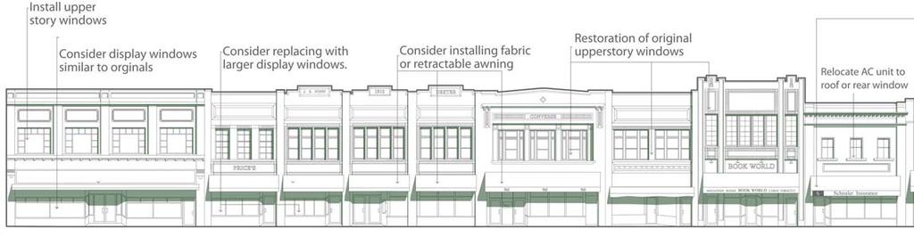
68 68 BUSINESS CORRIDOR REDEVELOPMENT PLAN 200 Block, west side of Washington Avenue 300 Block, west side of Washington Avenue 200 Block, east side of Washington Avenue 300 Block, east side of Washington Avenue
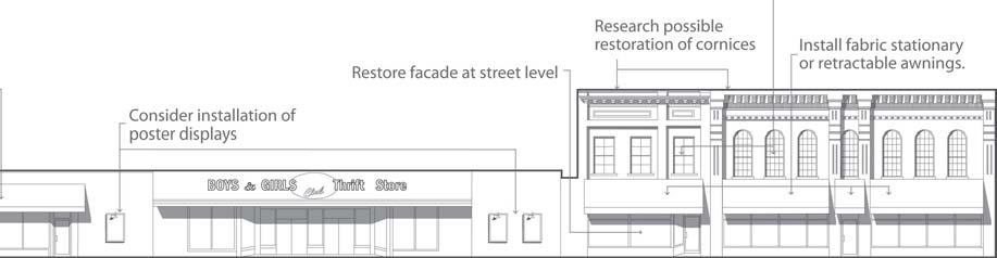
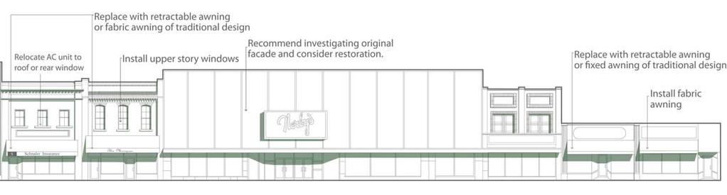
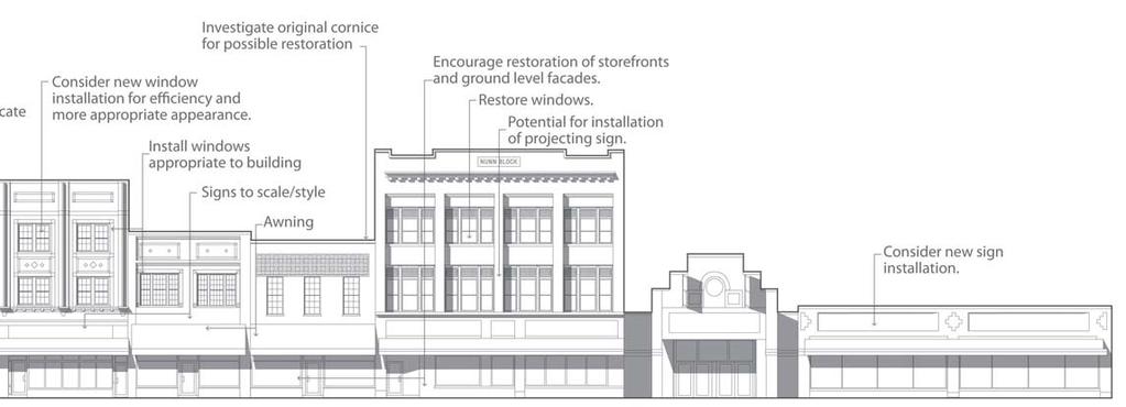
69 MASTER DEVELOPMENT PLAN 69

70 70 BUSINESS CORRIDOR REDEVELOPMENT PLAN St. Mary s District St. Mary s Regional Health Center continues to be an important part of downtown and anticipates significant future growth. Hospital campus development has significant implications for the central business corridors and generates demand for new types of uses, including medical retailing. The hospital and its consultants have coordinated a campus planning effort with this business corridor plan. Program The program for the St. Mary s District includes: A new clinical building and administrative facility. Internal, climate-controlled connections linking all hospital facilities. Expanded parking for both the main campus and North Annex. An internalized campus environment. Improved green space and wellness facilities. Sites for medical retailing. Components of the Concept NEW MEDICAL FACILITY AND CAMPUS. A new hospital administration and clinic facility is proposed at the terminus of Crescent Parkway along Frazee Street. The facility entrance would be on axis with Crescent Parkway, and well-defined crosswalks and an entrance plaza would link this entrance to the Crescent development area and the North Annex. This concept closes Lincoln Avenue at Frazee, creating an internalized campus environment. North of Oak Street, Lincoln Avenue would provide local access to the campus for staff, patients, and visitors. The new clinical/administrative building would be linked to the existing hospital, although this connection may require the eventual construction of a shared services building. MEDICAL RETAILING AND SERVICES. Medical retailing and services would develop along the Frazee corridor, with development sites including the northwest and southwest quadrants of Frazee and McKinley intersection. The first of these sites is part of the Crescent development area. NORTH ANNEX (MERITCARE DIALYSIS DETROIT LAKES). This project is discussed earlier as part of the Crescent development area. It includes demolition of the unoccupied part of the Annex, new parking on the resulting site, and a new entrance and façade for the Annex. This provides greater convenience for patients, a more attractive building, and more parking. PARKING. Parking is in short supply on the St. Mary s campus, and the problem will worsen with additional medical center development. Options to address this growing parking shortage include: Redesign and a possible parking deck at Washington and Frazee. Redesign can add stalls by increasing efficiency and reducing duplicative circulation. In the long-term, the site s topography aids construction of a two-story parking deck without internal ramping. Demolition of the eastern part of the North Annex. This adds about 50 stalls along the proposed Crescent Parkway. A future campus parking deck along the west side of McKinley Avenue. Topography again encourages development of a two-level deck without internal ramping. The deck would have a weather protected connection to the new clinical center and existing hospital. WELLNESS GREENWAY. Community health and wellness and the quality of the patient experience is important to the medical center and the community at large. The campus concept includes a Wellness Greenway, with paths that meander around ponds and water features that also help manage stormwater runoff. The Greenway is part of a linked greenway system connecting Downtown and the Crescent to Lincoln Park, City Park, and the lakefront.


71 MASTER DEVELOPMENT PLAN 71 3 Frazee Street 5 Crescent Parkway 2 St. Mary s Regional Health Center Campus. A view looking south towards new health care facility located at the crossing of Crescent Parkway and Frazee Street. The facility could be a signature building for the hospital and community Washington Ave Lincoln Ave Oak Street Sherman Street 7 McKinley Ave 1 Medical Facility and Campus 2 Medical Retailing 3 North Annex (Dialysis Building) 4 Parking Redesign, possible deck 5 New Parking 6 Future Campus Parking Structure 7 Wellnes Greenway 8 St. Mary s Regional Medical Center Map 4.4: St. Mary s District Development Area

72 72 BUSINESS CORRIDOR REDEVELOPMENT PLAN Community Center Connection The Detroit Lakes Community Center complex, including the community center, Historic Holmes Theater, and Becker County Historical Museum, is one of the study area s greatest assets, but seems separated from its other features. The complex, along Summit Avenue between State and Holmes Streets, adjacent to the new Chamber of Commerce headquarters and Detroit Lakes Fire Station, is less than two blocks from both Highway 10 and Mall s west entrance. This project concept is designed to connect the Community Center and surrounding civic uses to the Washington Avenue core, while providing more parking and creating substantial development opportunities. Program The program for the Community Center Connection includes: A permanent solution to parking shortages experienced by surrounding uses. A strong pedestrian connection between the Community Center and the downtown core. A significant, multi-use urban park that complements the community center and Holmes Theater. Potential for mixed-use development along Front Street. Components of the Concept PARKING STRUCTURE. The Community Center complex, Becker County Courthouse, and other uses west of Washington Avenue lack adequate parking. Expanding the north half of Washington Square Mall s parking lot into a two-level parking deck between the Mall and Summit Avenue would provide up to 600 parking stalls, solving this area s parking shortage for the conceivable future. This concept uses the site s topography to avoid internal ramping. The upper level, at grade with the Mall entrance, would have access points at Lake and Summit Avenues, while the lower level is accessed from Minnesota Avenue. PEDESTRIAN PROMENADE AND COMMUNITY COMMON. The existing east-west alley between Front and Holmes Streets would become a tree-lined and attractively lighted Promenade, linking the west Mall entrance with the Community Center s front door. The Promenade, on the south side of the proposed parking deck, would create a strong pedestrian connection between these two important assets. A public square is proposed adjacent to the Promenade on a quarter block northeast of the Minnesota and Frazee intersection. This urban park, midway between the Community Center and Mall, would be designed for outdoor events and performances as well as other park purposes. Oak Grove Ave State Street 5 6 Holmes Street Summit Ave Front Street Minnesota Ave 1 Parking Structure 2 Pedestrian Promenade 3 Community Common 4 Front Street Commercial 5 Community Center Site 6 New Becker County Museum Map 4.5: Community Center Connection FRONT STREET COMMERCIAL. New commercial, office, or mixed-use buildings would wrap the north side of the parking structure along Front Street. Multiple-story structures would have access from both parking levels. This concept avoids exposing the parking deck directly to the street, provides an attractive development opportunity, and activates Front Street between Washington Avenue and the community center. COMMUNITY CENTER SITE. A minor reconfiguration of the Community Center s parking and pedestrian circulation plan would add parking by increasing parking efficiency and align the community center entrance with the Promenade. A pedestrian-priority crossing should be established as the Promenade intersects Summit Avenue. MUSEUM. The Becker County Museum has developed preliminary plans for a new facility. Current plans are to place the facility on the same site as the existing facility, phasing construction to minimize disruptions to the museum operation. EVENT CENTER. The Community Center complex provides a potential site for the event center. The new building would be connected to the Holmes Theater on the north side of the complex, placing a new museum on an adjacent site. The Event Center section of this chapter describes alternatives in more detail. 4 3 Lake Ave

73 MASTER DEVELOPMENT PLAN 73 Front Street Summit Avenue Parking Structure and Commercial Uses. A new parking structure between Front and Holmes Streets and immediately west of Washington Square Mall, would have two parking decks, both with access from at-grade. The slope of the Front Street permits access to the lower level near Summit Avenue and access to the upper level near the Mall entrance. Commercial or office buildings could wrap the north edge of the structure.

74 74 BUSINESS CORRIDOR REDEVELOPMENT PLAN North Washington North Washington is the forgotten gateway to the city center, providing the most direct downtown access from Highway 34. The BNSF and Highway 10 corridors separate North Washington from the main downtown center, causing the some decline in its commercial environment. The North Washington segment presents several good development possibilities that can strengthen the north side of the city as well as the immediate business environment. Program The program for the North Washington district includes: Reuse of the underused commercial triangle on the west side of North Washington between the railroad and Grant Street. An improved connection to the railroad depot and across the Highway 10 and railroad corridors to Downtown. A residential development on the Washington School site. An improved north gateway to the central business corridors from Highway 34. Components of the Concept NORTH WASHINGTON IMPROVEMENTS. Becker County plans to resurface North Washington and make other supporting improvements. These improvements should include: Intersection nodes in the commercial area south of Union Street. Lighting and street furniture in this area consistent with the Downtown concept. Bike lanes north to Highway 34. A raised median between Grant and the railroad, defined by a contrasting paving material or landscaping. RAILROAD DEPOT. The historic Detroit Lakes Depot is located between Highway 10 and the BNSF main line, and will become a multi-modal transportation center serving Amtrak, the tribal transit system, and inter-city buses. The depot plan also includes an arts center and store operated by the White Earth Tribe. The area west of the depot will provide parking and space for bus operations. This plan recommends a public plaza that connects the depot to North Washington. The plaza may include landscaping, street furniture, and informational or interpretive kiosks. Map 4.6: North Washington Development Area Street Improvements 2 Railroad Depot 3 Dining Car 4 Commercial 5 Multi-family Townhouses 6 Preservation of Existing Uses 7 Washington Elementary Reuse 8 Commercial Node 9 Highway 34 Gateway
 images looking north along Washington Avenue from Central Street.")

75 MASTER DEVELOPMENT PLAN 75 Streetscape Enhancements. Before and after (concept) images looking north along Washington Avenue from Central Street. The concept shows a street section with parallel parking on both sides of the street with a dedicated bike lane. Improvements include street trees, new sidewalks, and new lighting standards that continue the theme in the downtown core.


76 76 BUSINESS CORRIDOR REDEVELOPMENT PLAN HIGHWAY 10 INTERSECTION. The width and angle of the Highway 10 crossing creates difficulties for most pedestrians. The new intersection includes a countdown walk signal, but a refuge median would increase pedestrian safety and comfort. A depot plaza and the proposed public space at the head of the Crescent can also add pedestrian scale to this very difficult intersection. MAIN STREET REDEVELOPMENT SITE. The site between the BNSF and Grant Street west of Washington provides a substantial development opportunity. Both concepts would include a railside park and ornamental barrier, to both buffer and enhance the railroad corridor. This park could include a thematic commercial use such as a diner, possibly using a converted railroad dining car. Concept One includes: A main street with on-street diagonal parking using Main Street and Lake Avenue. A multi-bay commercial building along Main Street, facing the railroad and depot. A new multi-family residential building facing west along Lake Avenue. Preservation of existing commercial buildings, including the VFW, southwest of Washington and Grant. Off-street parking on the inside of the redevelopment block. Components of Concept Two include: Vacating Main Street, using the redevelopment site for a commercial or recreational small-box. A new bowling alley is one use that the site could accommodate. Parking access would be from Grant Street to the north. Preserving existing commercial buildings, including the VFW, southwest of Washington and Grant. WASHINGTON SCHOOL REDEVELOPMENT SITE. Affordable residential development would be an effective reuse of the now-vacant Washington School site. A reuse program includes a housing conversion of the historic school building, using lowincome and historic tax credits; street-oriented townhouses facing Washington, Union, and Central; and parking and garages in the interior of the block. HIGHWAY 34 GATEWAY. The intersection of Highway 34 and North Washington presents a direct link to Downtown and potential development sites on either side of the street. A development program for this intersection includes: A gateway feature to reinforce North Washington as a direct route to Downtown. An open space could be defined by the design of development on either side of the street, and could combine attractive ornamental landscaping with three-dimensional elements such as public art or natural stone. Development of sites on either side of North Washington on the south side of the highway. Small offices or retail uses are appropriate at this site. Building configuration should define gateway plazas, with parking furnished to the south of the buildings. A traffic signal may be warranted at Washington Avenue and Highway 34. This signal would strengthen North Washington s gateway status.


77 MASTER DEVELOPMENT PLAN COMPONENTS OF CONCEPT 1 1 Main Street with Diagonal Parking 2 Multi-bay Commercial Development 3 Multi-family Development 4 Preservation of Existing Commercial 5 Off-street Parking 6 Railside Park & Diner COMPONENTS OF CONCEPT 2 1 Vacated Main Street 2 Potential Bowling Alley 3 Commercial Uses 4 Preservation of Commercial Uses 5 Off-street Parking 6 Railside Park & Diner Converted railroad dining car at the new Railside Park (below). This commercial use would be a signature feature on the northside of the railroad tracks. Example of a railcar converted to a diner.


78 78 BUSINESS CORRIDOR REDEVELOPMENT PLAN South Washington South Washington Avenue is the main connection between downtown and the lakefront, and should be a processional spine linking the city s major features. Program The program for South Washington Avenue includes: An improved public environment linking Downtown, City Park, and Lake Detroit. An upgraded terminus for Washington Avenue and functional and aesthetic redesign of the West Lake Drive intersection. Capitalizing on Washington Ballpark as a major community asset. Components of the Concept WASHINGTON AVENUE PAVEMENT MARKINGS AND BIKE LANES. South Washington Avenue should be restriped to include parallel parking, five-foot bike lanes, and two traffic lanes. These measures will provide bike route continuity and calm traffic. STREETSCAPE COMPONENTS AND CROSSINGS. Streetscape elements similar to those proposed the downtown core create continuity between the downtown and lakefront districts. These concepts also contribute to a more pedestrian-friendly processional corridor. Intersection nodes would be established at Willow Street, Langford Street, and Park Drive, with midblock nodes and crossings between Frazee and Willow (serving senior housing) and Willow and Langford. WASHINGTON BALLPARK. This evocative 1920s-vintage stadium is an important feature on South Washington Avenue. The street-facing backstop could be refaced in the style of a traditional ballpark, with a corner plaza that celebrates people who played at the ballpark. A pathway connection should lead from Lincoln Park, cross Langford Street, and connect through the ballpark site to City Park and the lakefront. This is part of greenway system parallel to Washington Avenue that extends from the Crescent development area to the lake. WEST LAKE DRIVE TRAFFIC CIRCLE. Traffic circulation at the intersection of West Lake Drive and South Washington Avenue has concerned both residents and visitors to the lake. The street pattern in the area often cause people to make circuitous trips through residential areas and traffic sometimes moves Historic Carnegie Library through the existing curve connecting Washington and West Lake at unsafe speeds. A roundabout at this intersection will help people reverse direction at the end of Washington Avenue, calm traffic, and provide an attractive amenity for both the Pavilion and possible private development on the northwest corner. The center of the roundabout should include colorful landscaping and may provide a more visible new location for the iconic boat sculpture at the beach. BUSINESS SIGNAGE. Only on-premise business identification signs should be permitted along South Washington. All signs should be either attached (wall, awning, or projecting signs) or monument signs. CARNIGIE LIBRARY. Trimming the shrubs and trees around the library will expose some of the rich architecture in Detroit Lakes.


79 MASTER DEVELOPMENT PLAN 79 Map 4.7: South Washington Development Area Frazee St 8 1 Willow St 7 1 Lincoln Ave Streetscape Enhancements. Ornamental street lights and corner nodes are major elements of the streetscape design for South Washington Langford St Forest St Park Drive 2 West Lake Drive 5 1 Washington Ave Pavement Markings 2 Trail Path 3 Ice Skating Pond 4 Washington Ballpark 5 West Lake Drive Traffic Circle 6 Business Signage 7 Washington Ave Crossings 8 Carnegie Library

80 80 BUSINESS CORRIDOR REDEVELOPMENT PLAN Lakefront District Detroit Lakes takes its name and derives its community image from its greatest natural asset. The quality and use of the public space along the lake and the development environment of West Lake Drive are vitally important to the city s economy and environment, and are fundamental concerns of this business corridor plan. Land use and economic changes have affected the lakefront environment. For example, lakeside resorts that served short-term vacationers created a lively commercial market along the lake. The decline of the resorts and their replacement by seasonal condominiums have reduced this market, and, in the opinions of many local observers, also reduced the activity and vitality of the lakefront. Economic trends have also favored residential land development over the risks and limited potential of highly seasonal retailing. Planning for a future lakefront must accommodate these economic trends and market preferences, while maintaining the liveliness that is part of the Detroit Lakes tradition. The Program The program for the lakefront development area includes: Creating opportunities for both future retail and residential development. Establishing a redevelopment concept for the strategic but commercially underused block of West Lake Drive between Washington and Lake Avenues. Improving bicycle and pedestrian accommodations along the beachfront. Improving parking and traffic circulation throughout the district. Preventing encroachment of parking and commercial uses into adjacent residential neighborhoods. Components of the Concept WEST LAKE DRIVE AND THE BEACHFRONT. Many great urban beach environments, from Detroit Lakes to Santa Monica, almost always provide a grand processional environment a promenade where people can walk or cruise by bikes and observe the life of the beach without actually getting wet. Tree-lined West Lake Drive provides the opportunity for this kind of beachfront experience. The beach walk now is limited to a four-foot path that separates the sand beach from a gentle grassy slope up to the street. This existing path is very useful it provides a clean edge between sand and grass and furnishes a solid walking surface along the edge of the sand beach. But it does not provide the kind of promenade that the lakefront needs. Its side slope of the walkway is difficult for runners and it is too narrow for its variety of users. These problems have produced frequent proposals to close West Lake Drive to vehicular traffic, or otherwise restrict movement along the street. A better solution would be moving the curb of West Lake Drive north to add space for a 12-foot boardwalk between the edge of the trees and the new curb. The new street section would be adequate for two-way circulation and a parking lane on the north side. An on-street parking lane on the south side would Map 4.7: Lakefront District Development Area 1 West Lake Drive 2 Beachfront 3 Park Drive Extension 4 Mixed Use Development 5 Townhouses 6 Roundabout 7 Pavillion 8 Lakeside Tavern 9 Zorbaz 10 Beach House Rossman Ave Summit Ave 3 Minnesota Ave Lake Ave Washington Ave 6 7 West Lake Drive Legion Rd 10


81 MASTER DEVELOPMENT PLAN 81 Mixed Use Development. Above concept shows mixed use development at Washington Ave and West Lake Drive. Left image is an example of mixed use development in Colorado. Below image is another example of mixed use development in Iowa.


82 82 BUSINESS CORRIDOR REDEVELOPMENT PLAN be lost, but recent practice has prohibited parking on this side of the street between Memorial Day and Labor Day in any case. The new boardwalk could be differentiated into pedestrian and bicycle tracks, delineated by different pavement colors and markings. This boardwalk is most appropriate for slowmoving, cruising cyclists. Sharrows should be used on West Lake Drive for cyclists moving at vehicular speeds. Figures 4.1 and 4.2 display how the existing street would be converted to develop the beachfront promenade. PARK DRIVE EXTENSION. The community has periodically considered a new street paralleling West Lake Drive to relieve traffic and possibly replace the lakeside street. The long block between West Lake and Forest Street has poor local traffic flow and channels traffic almost exclusively along the lakefront. Additionally, the lack of an edge between commercial and parking uses fronting West Lake Drive and residential neighborhoods has caused some land use conflicts. A parallel circulator street would initially extend from Rossman Avenue through Peoples Park, using the existing Peoples Street, and continue east to Washington Avenue, aligning with Park Drive. A later extension could continue west along the edge of the Becker County Fairgrounds and Legion Park to Legion Road, opening this site up to future development. Various alignments could be considered to reduce minimize acquisition of residential property. The street design should also include traffic calming devices such as neck-downs to prevent unwanted traffic on north-south residential streets. The alignment with Park Drive will require acquisition and future redevelopment of the now vacant motel along Washington Avenue. The alignment illustrated in the concept master plan illustrates the most direct route from Rossmore and Peoples Street to Washington and Park Drive and provides the largest development site between the new street and West Lake Drive. Various alignments could be considered in place of the concept shown in the plan. Advantages of the new street concept include: Improving neighborhood circulation and access to commercial parking, and creating opportunities for new lakefront district parking. Discouraging lakefront traffic from entering residential areas in search of parking. Defining and buffering the edge of the lakefront district, in turn preventing encroachment of more intensive land uses into the adjacent single-family residential area. Encouraging redevelopment of the West Lake and Washington intersection. Changing traffic circulation patterns, including opening the possibility of closing West Lake Drive for special events, or considering permanent reductions of motor vehicle traffic on the street. MIXED USE DEVELOPMENT AT WASHINGTON AND WEST LAKE DRIVE. The northwest quadrant of the South Washington Avenue and West Lake Drive intersection, extending west to Minnesota Avenue, is a highly visible and strategic development site that has experienced declines in commercial vitality. The site presents a superb opportunity for high-value, mixed use development that can incorporate both residential and retail/entertainment development. The concept illustrated by the master plan includes: A mixed use development oriented to Washington and West Lake, strongly defining the intersection at the proposed roundabout. This key elevation would face the Pavilion across the roundabout, and should also provide a significant urban plaza. Retail, restaurant, and other Park Drive alignment with most direct route to People s Street Park Drive alignment meanders around existing housing. Park Drive alignment option.
 images looking north along Washington Avenue from Central")


83 MASTER DEVELOPMENT PLAN 83 Streetscape Enhancements. Before and after (concept) images looking north along Washington Avenue from Central Street. The concept shows a street section with parallel parking on both sides of the street with a dedicated bike lane. Improvements include street trees, new sidewalks, and new lighting standards that continue the theme in the downtown core. Streetscape Enhancements. Example of a contrasting pavement surfaces to distinguish pedestrian and bike zones in Boulder, Colorado.


84 84 BUSINESS CORRIDOR REDEVELOPMENT PLAN commercial uses would occupy the street level, with residential and limited office development on upper levels. The building form maximizes views of City Park and the lake. Existing retail anchors, such as Lakeshirts and Lakeside Tavern, which are incorporated into the project design. Additional commercial/mixed use row development west of Lakeside Tavern to the Minnesota Avenue intersection. Townhouses along Minnesota, Lake, Washington, and the proposed Peoples Street/North Shore Drive connection, to transition to single-family residential areas to the north. Extensive street landscaping along the North Shore extension. Internal parking on the redevelopment site, surrounded by new development or existing businesses, and a new parking area between Minnesota and Summit, off the proposed connector street. This substantially increases the supply of parking available to the lakefront. A pedestrian path through the development to connect Peoples Park with City Park. ROUNDABOUT AT THE FOOT OF WASHINGTON AVENUE. This concept is presented in the South Washington section. WATER QUALITY. Exotic plant life in the water affects the quality and use of the beach. The City has experienced success in controlling the introduction of new invasive plants, but struggles with eradicating more mature plants. State agencies are developing new methods to address this issue. Measures that manage stormwater runoff into the lake also help preserve water quality. EVENT CENTER. The Lakefront District is a potential site for a new event center. A lakefront location would also include an attached hotel. An event center/hotel concept is interchangeable with the mixed use development at the Washington and West Lake intersection, proposed above. The next section discusses this concept in more detail.


85 Traffic circle designed by RDG in Coralville, Iowa. MASTER DEVELOPMENT PLAN 85

86 86 BUSINESS CORRIDOR REDEVELOPMENT PLAN Event Center Options Detroit Lakes has discussed the market for an event center, using the city s physical assets, character, and strategic location to attract local and regional conferences and events. As part of this overall business corridor planning process, Economics Research Associates (ERA) prepared the Event Center Market Analysis to define the market, feasibility and character of such a facility. The analysis found that: A market exists for additional meeting space in Detroit Lakes. Meeting/event space should be part of a larger package of offerings provided by the public sector, which also includes recreational and educational facilities, cultural venues, and basic public services. A facility should address both local needs and new, nonlocal business that can generate new economic activity and increase tourism. The facility should be connected to either an existing or new hotel. Generally, facilities are typically not self-sufficient, requiring a public sector role. As a result, the city should collaborate with a private developer to build lodging and manage ongoing activities of the event center. The Detroit Lakes Event Center should include 7,500 square feet of ballroom space that can be broken down into three smaller rooms, and 2,500 square feet of additional breakout space. An additional 10,000 square feet is required for support space, including administrative offices, washrooms, food and beverage preparation/service areas, and storage. Total projected gross floor area is 20,000 square feet. The ERA report is included as an appendix to this plan. The Detroit Lakes Business Corridors Plan used these findings to guide development of three development options: ClubHouse Hotel Site, adding a new events center to the existing ClubHouse Hotel, a full-service facility on US Highway 10. Washington Avenue and West Lake Drive, opposite the Pavilion and adjacent to Lake Detroit. Detroit Lakes Community Center, adding an event center to the existing community center complex. Map 4.8: Event Center Options


87 MASTER DEVELOPMENT PLAN 87 Site 1: ClubHouse Hotel This option adds an event center wing to the existing ClubHouse Hotel, previously a Holiday Inn franchise. A similar concept was implemented in Watertown, South Dakota, with the addition of the Watertown Event Center to the Ramkota Hotel. The Watertown facility provides 32,000 square feet of event space. Highway 10 The new facility addition would be to the west of the existing hotel, joined by a concourse adjacent to the pool area and connecting directly to the hotel lobby. Site parking would be expanded and drop-off and servicing areas improved. The configuration provides space for outdoor recreation and has a lakefront exposure. Event Center Existing Hotel Advantages of this option include: Direct and convenient access and high visibility along Highway 10. Private lakefront access. Proximity to other hotels along the Highway 10 corridor. Utilization of a pre-existing hotel facility. Ability to complement existing event facilities, including meeting space in the hotel. Possible disadvantages include: Few spin-off development benefits on major business corridors. Limited exposure to key community amenities. Relatively low image site. Perception that center is owned by one hotel operation.


88 88 BUSINESS CORRIDOR REDEVELOPMENT PLAN Site 2: Washington Ave & West Lake Dr This option would develop a new event center and hotel in place of the mixed use development proposed as part of the Lakefront District development concept. In this concept, a hotel with street level commercial possibilities would be located at the corner opposite the Pavilion, while the event center would be adjacent to the north, with frontage along Washington Avenue and the North Shore Drive extension. Townhouses or mixed use development would develop on the western edge of the site, along Minnesota Avenue, and Lakeside Tavern and Lakeshirts would complete the U-shaped building arrangement. Interior parking would gain major access from the new street connector, with extensive landscaping to buffer this complex from the residential neighborhood to the north. Possible disadvantages include: Substantial land acquisition. Probable requirement for new North Shore Drive extension for parking access and traffic management. Requirement for hotel development. Possible traffic and parking impact on residential areas. Likelihood of highest development cost among options. Relatively indirect highway access. Advantages of this option include: Location at Detroit Lakes signature location. Opportunity to activate the lakefront and provide yearround support for lakefront businesses and restaurants. Reinvestment in an underused site, and potential to reinvigorate the retail environment. Event Center Hotel Parking Structure Front St Nearby beachfront, park facilities, St. Mary s, and the Downtown core. Ability to take advantage of the Pavilion for special events. Summit Ave Museum Highest potential development return.


89 MASTER DEVELOPMENT PLAN 89 Site 3: Community Center This option adds an event center to the Community Center, attaching the new facility at the Historic Holmes Theater. The building site terminates Front Street, completing a u-shaped arrangement around parking and public areas. Additional surface parking would be provided east of the new center, between Minnesota and Summit Avenues, with auxiliary parking to the north. The east parking could eventually be upgraded to a two-level parking deck, as proposed above for the Community Center Connection development area. In this concept, the Becker County Museum would be developed on a new site across from the community center at the northeast corner of Holmes and Summit. This staging would allow completion of a new museum without disruption of the existing facility. The adjacency of this option to the Community Center provides substantial possibilities for local use. Hotel development would probably trigger construction of at least a portion of the parking deck proposed as part of the Community Center Connection program. The hotel would wrap part of the north exposure of this parking deck. A skywalk across Summit Avenue would provide a weather protected connection to the event facility and community center. Limited land acquisition requirements in initial project phase. Relatively convenient access to Highway 10 corridor Possible disadvantages include: Required relocation of Becker County Museum. Requirement for early stage parking solution. Requirement for hotel development, somewhat moderated by local use possibilities. Potential but manageable traffic and impact on residential areas. Mixed Use Mixed Use West Lake Dr Park Dr Extension Event Center Hotel Washington Ave Advantages of this option include: Excellent and extremely flexible use possibilities with colocation with Holmes Theater and Community Center facilities creates. Maximum local use and minimized risk because of community center location. Spin-off benefits for Downtown core and Washington Square Mall. Multiple-use parking that addresses overall parking shortages. Available hotel site that meets overall business corridor development objectives. Phasing opportunities that reduce early development costs.

90 90 BUSINESS CORRIDOR REDEVELOPMENT PLAN Connections The previous discussion has considered major development areas that together create the business corridor development vision. These recommendations unify study area features together and connect them to the rest of the city. Connections include: LINKAGES TO DETROIT LAKE BICYCLE CONNECTIONS COMMUNITY GRAPHICS & VOCABULARY WAYFINDING ENHANCEMENTS Linkages to Detroit Lake The business corridors program (and an overall community investment effort) should maximize access from all parts of the city to Detroit Lake. Additionally, a key element of this plan is a continuous greenway that extends from Downtown to the lake. This core to lake connection can be accomplished through the following concepts: Core to Lake Greenway. While Washington Avenue is the most direct connection between the lake and the city center, the plan also provides a more leisurely greenway walk away from major streets. The Core to Lake Greenway begins at the Crescent Gateway Plaza at Washington and Front and continues through the proposed Veterans Memorial Park. It crosses Crescent Parkway at the south edge of the park, and continues through the triangular park and greenway on the west side of the new street to Frazee Street. The greenway crosses Frazee at the protected crossing and continues south through the St. Mary s campus along the Wellness Greenway to Oak Street. Leaving the hospital campus on Oak, the green path continues to Lincoln Avenue and proceeds south, crossing Willow Street and entering the Lincoln Park skating pond. It continues across Langford Street through the Washington Ballfields area to the Pavilion, City Park, and City Beach. The greenway could be enhanced by interpretive information, special graphics, and public art. Cross Connections. The north-south Core to Lake Greenway includes a north connection along North Washington, using an improved pedestrian crossing at Highway 10. The primary link crosses Washington Avenue at Front, continues north past the Graystone Building, crosses Highway 10 to the Depot Plaza and continues north past the Main Street and Washington School redevelopment sites to Highway 34. A west connection uses the pedestrian access of the redesigned city parking lot to Washington Avenue, continues through the Mall, and proceeds west to the Community Center via the proposed Community Center Promenade. Heartland to Lake Link. An east-west trail and pedestrian link connects the planned Heartland Trail extension from Park Rapids to the lakefront and crosses the Core to Lake Greenway at City Park. The trail is currently planned to enter the city along Highway 10. The route begins at the Highway 10 and North Shore Drive intersection, the site of the ClubHouse Hotel, and follows North Shore Drive, currently signed as a bicycle route and including a wide sidewalk to City Park. The route continues round the proposed roundabout, continuing west along the beachfront Promenade to an existing trail that connects to Muskrat Lake and Lake Sallie. For cyclists, the bike route circumnavigates Detroit Lake, and reconnects with the Heartland Trail. Bicycle Connections The lake connections described above are important parts of a pedestrian and bicycle system. In addition to these routes, Washington Avenue should include bike lanes between Highway 34 and Detroit Lake, and sharrows should be used with appropriate signage along North Shore Drive and West Lake Drive. In addition, the city should complete a study of its street system to identify and appropriately designate on-street bicycle routes that lead to important community destinations and connect to the business corridor network. Designation and pavement marking techniques include: Sharrows (or shared use arrows) in shared lanes on streets with inadequate width for bicycle lanes. Bicycle lanes on streets with the width to accommodate them. A typical minimum for streets with two-way traffic, bicycle lanes in each direction and on-street parking on both sides is 46 to 48 feet. Single-direction lanes or parking restrictions reduce this minimum.

91 MASTER DEVELOPMENT PLAN 91 Gateway Community Center Depot Gateway Memorial Public Green Park St. Mary s Wellness Walk Skating Pond Park Ballfields City Park to Highway 59 to Heartland Trail
 also permits incorporating community identifying logos in these signs.")
92 92 BUSINESS CORRIDOR REDEVELOPMENT PLAN Share-the-road signage on designated routes. Special signage that uses designated numbered routes and destination signage. The 2008 proposed Manual of Uniform Traffic Control Devices (MUTCD) also permits incorporating community identifying logos in these signs. A special system logo, designating a Bike Detroit Lakes system, should also be considered. Community Graphics and Vocabulary Detroit Lakes should communicate its distinctive identity to visitors. Features with unified designs placed at strategic points can express these community themes. Community Graphic Design System. A community environmental graphics system, featuring a common logo, wayfinding signage, destination graphics, and other elements, provides important information to visitors, markets assets, and reinforces city marketing efforts. The system begins with a community logo, and a sailboat image is already in used frequently to represent the town and its environment. Sign design, including placement, size, types of graphics, color, and font styles are other elements to consider in a comprehensive graphic design program.» Soo Pass Ranch» Trailheads» Long Lake» St. Mary s Medical Center» North Washington District» Community College» Becker County Fairgrounds» Legion Park Materials. Unified design standards and construction materials in the public environment reinforce a sense of quality and order. For example, planters and street furnishings used in the Downtown Core and the Crescent should be consistent in materials and form. Plantings. Plant selection in the public environment should reinforce community themes. Street trees planted at regular intervals can define major corridors and provide shade. Consistent palettes of plants used in planters, flower baskets, and other locations within close areas can also strengthen the composition of individual elements in the public realm. A wayfinding system is especially helpful to visitors, but also useful to residents. Well-designed systems recognize that signs must be read at different speeds, and often use different sign types, such as blade signs, in pedestrian-scaled districts, such as the Downtown core or Crescent. Other important criteria for wayfinding systems include providing a continuous path from major approach routes to destinations, and avoiding the clutter and confusion of using too many signs. Generally, a good system includes:» Gateway signs at key community entrances, welcoming the traveler to the city and identifying destinations.» Directional signs at key decision points along the path.» If necessary, destination arrival signs. Destinations that could provide the structure for a Detroit Lakes system include:» Downtown» Becker County Courthouse» City Park» City Beach and Lakefront» Detroit Lakes Community Center» Becker County Museum Gateway sign
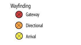
93 MASTER DEVELOPMENT PLAN 93

94 94 BUSINESS CORRIDOR REDEVELOPMENT PLAN Streetlighting and traffic signals. Historically, Washington Avenue streetlighting used globe fixtures during the 1920s and acorn fixtures during the 1940s and 1950 s. These ornamental fixtures were replaced with the ubiquitous cobra head lamps, mounted to galvanized poles. The Highway 10 project recently introduced an attractive teardrop fixture to the streetlighting vocabulary. Globe, acorn, or teardrop fixtures are all appropriate in the central corridors streetscape. Currently, most traffic signals are mounted on galvanized mast-arms and poles, inappropriate to the physical character of pedestrian-scaled districts. A new streetscape installation should powder-coat existing support structures with dark color paint, or replace them with new, more historically appropriate design. Policies The previous elements of this vision plan establish the physical parameters of the Development Concept. This section addresses policy considerations for key issues and components of the plan, including: RETAIL AND SERVICE DEVELOPMENT HISTORIC PRESERVATION POLICY HOUSING DEVELOPMENT Some of these principles repeat concepts that have been discussed earlier. In these cases, they will simply be restated. Retail and Service Development Overall Policy: Consolidate and strengthen the existing retail and service environment, stabilizing existing retailers, expanding the number of people who come Downtown for activities, filling available space, and expanding the supply of space. Concentrate new businesses in areas of demonstrated potential strength for the central business corridors: food and beverage, commercial recreation, medical and health/fitness-related retailing, value-based specialty retailing, furniture and home furnishings, and office support retail and services. Increase the demand for retail space in the market by increasing the number of people who use Downtown as a destination, and connecting Downtown to other community attractions. Encourage retail development along the lakefront. Actions and Program Directions: To the maximum degree possible, encourage retail/restaurant/personal services rather than office use of individual storefronts with street exposure along Washington Avenue between Highway 10 and Frazee Street. Provide office development sites adjacent to Washington Avenue but off the major retail corridor. Develop the Crescent as the front door to Downtown, using its high visibility from Highway 10 to attract major restaurants and other commercial businesses that usually locate along highway strips. Envision the Crescent as a transition from the highway environment to the main street environment by providing a highly attractive, pedestrian-oriented public realms within direct view of the road. Within the Request for Proposals process, establish criteria for business targets within the Crescent and evaluate proposals based on the ability of competitors to deliver on these criteria. Consider seeking designation as a Main Street Community. This program, being restarted in Minnesota, provides low-cost consulting services that advise retailers on marketing, window display, and merchandise presentation. In addition, engage Detroit Lakes proven and innovative retailers as mentors for potential new retail and service entrepreneurs.


95 MASTER DEVELOPMENT PLAN 95 Aggressively market and recruit retailers in the Crescent and Downtown, matching needs with available space. Focus on areas of demonstrated potential for Downtown and in-town retailing, including opportunity gaps where local retail spending exceeds the locally-based sales. Reinforce the City s program of events with other special themes and promotions. Provide high quality ongoing events that complement traditional celebrations like the rodeos, and extend fun and festivity throughout the year. Promote high standards of customer service to strengthen the district s identification with local consumers. Publicize these standards through a Customer Commitment Contract, prominently posted in all retail and consumer service businesses. Assure that the most convenient parking in the area is reserved for customers. Take extra steps to put fun and festivity into the wntown shopping experience. New amenities should enrich the experience of living and working in the District. Identify special niches and help put projects together that responds to these concepts. Projects may group a number of related, small retailers, artisan, or service providers in a single large space. Historic Preservation Policy Historic preservation and adaptive reuse are important to the central corridors, with four National Register listings: the Graystone, Carnegie Library, Holmes Block, and Depot, and a number of important eligible sites and other contributing buildings. This plan strongly recommends a building development policy that uses preservation and adaptive reuse as cornerstones. The exemplary Graystone project demonstrates the importance of policies that encourage preservation and adaptive reuse. Components of this policy include: Adopting flexible building codes that encourage upper level residential adaptive reuse. Housing development has been a foundation of successful downtown revitalization around the country and has also been important to Detroit Lakes. Federal tax incentives, construction costs, the nature and preferences of residents in urban districts, and knowledge of successes in other Minnesota cities and historic districts can encourage residential use of upper levels. Detroit Lakes should review building codes to ensure that they encourage adaptive reuse without compromising health, safety and welfare. and help downtown property owners to rehabilitate downtown structures. The city should also consider reasonable design standards to guide reuse and rehabilitation projects. Providing gap financing for major rehabilitation projects. Appropriate historic rehabilitation may not be economically feasible without some form of financing assistance or participation. Elements of a potential financing program for projects in Detroit Lakes include:» Historic tax credits. The historic tax credit provides a 20% investment tax credit against passive income for certified rehabilitation projects.» Tax Increment Financing. The city should consider TIF to leverage substantial rehabilitation efforts. Use of TIF depends on local tax rates. Alternatively, a portion of other, energy-related revenue sources may be used to assist with financing of downtown projects.» Community Development Block Grants. CDBG funds can be used to provide gap financing for projects that meet statutory requirements for the program.

96 96 BUSINESS CORRIDOR REDEVELOPMENT PLAN Downtown growth is a process, and natural growth includes change as well as preservation. However, new downtown construction should retain a strong street orientation and preserve the fabric and patterns of traditional Downtown buildings. Washington Square Mall is an example of a major project that incorporated historic facades and maintained a main street scale along Washington Avenue.» HOME Housing Investment Partnership funds may also be used for projects, including new construction ownership developments that are targeted toward low and moderate income households.» Preservation Easements. Donation of façade easements can provide meaningful tax advantages to building owners and can open some avenues of public financing for façade restoration.» Other local public and private resources. The public and private sectors could collaborate to offer financing that provides a real incentive to participants. The result could have major benefits to both property owners and the community s business community. Utilizing design guidelines. The Secretary of the Interior s Standards provide an excellent starting point for evaluating downtown rehabilitation projects. Particularly important is restoration of buildings that have been modernized or severely modified with unsympathetic facades. New development in the downtown core should preserve the scale, materials, and character of traditional architecture in the District. The illustration below shows potential retrofits for some building facades, showing examples of ideas for façade improvement. Priority elements include display windows, upper-story window installations, restoration of façade materials, and awnings. Infill development that respects the existing character of the district. Sometimes, rehabilitation is not feasible because of structural deterioration or economic issues. Housing Development The central business corridors development program should place a high priority on new housing development and adaptive reuse of upper levels for residential development. As discussed earlier, housing is a key element of most central city revitalization programs and is important to this plan s vision of the future of business corridor as a lively mixed use neighborhood. Residential development makes downtown a living, 24-hour neighborhood. Housing development policy in and near the downtown core includes both upper level adaptive reuse and new construction where opportunities present themselves. Many upper-level units will initially be rental, although some may provide owneroccupied apartments for people who live over their businesses or otherwise seek equity settings. Existing tax-driven incentives such as the Low-Income Housing Tax Credits and Historic Tax Credits are oriented to rental housing. Public actions and policies necessary to encourage delivery of downtown housing include preservation codes and building permit policies that encourage upper level reuse, production financing programs including the use of available federal tax credits, and dedication of some spaces in off-street parking lots for residential use. In some cases, shared vertical circulation and cooperative development of several adjacent buildings can improve project feasibility. The lakefront is likely to generate higher market values than the downtown core. Higher-density housing here uses the valuable resource of the urban lake exposure more efficiently. Mixed use development, with commercial development at street level accommodates both the retail and residential markets and, ultimately, produces a more active lakefront.


97 IMPLEMENTING THE PLAN 97 5 Implementation The Business Corridor Redevelopment Plan presents an ambitious and varied program for improving the heart of the City. This chapter considers several factors necessary for plan implementation, including ORGANIZATIONAL STRUCTURE PRIORITY CRITERIA PROJECTED DEVELOPMENT COSTS & IMPLEMENTATION SCHEDULE FUNDING TECHNIQUES


98 98 BUSINESS CORRIDOR REDEVELOPMENT PLAN The Plan and its scheduling will inevitably change over time. Some projects may advance as opportunities or demands open, while others will fade in importance. Yet, the overall vision is compelling and will result in vibrant, productive central business corridors. This section provides tools to help the city and stakeholders in these districts move ahead and make necessary mid-course corrections on the journey to accomplishing this vision. Organizational Structure This section considers organizational aspects of the business district and offers recommendations that can further strengthen the support structure for the business corridor. Successful development efforts require successful organizations and public/private partnerships. The City of Detroit Lakes has been a strong participant in downtown s economic development process and enjoys a good relationship with the Detroit Lakes Development Authority, Chamber of Commerce and Midwest Minnesota Community Development Corporation. These partnerships will continue to grow as the development process continues. Staff A full- or part-time staff position, a Business Corridors Development Manager, should be established under the aegis of the Planning and Economic Development Department to manage the business corridor development process. A partnership of the Detroit Lakes Development Authority and City of Detroit Lakes would meet on a regular basis to recommend implementation priorities to the Community Development Director and oversee implementation. Day-to-day plan implementation would be carried out by the corridors development manager, under the direction of the Community Development Director. The focuses of this new position should include: Improving the state of Downtown by increasing the number of businesses and employees, business sales volume, property values, number of residents, average household income, and number and variety of cultural activities and venues. Coordinating development efforts by existing businesses and attracting new development. Maintaining and managing Downtown improvements. Measuring success in improving the condition of Downtown. Developing marketing material directed to attracting patrons to downtown. Coordinating efforts of the Downtown Business Association, Chamber, City, MMCDC, Development Authority and community museums and ensuring continued cooperation. Developing joint marketing materials and expanding the program of events. Downtown should offer regular programming during the course of the year to keep things happening in the district. Alternatively, the corridors development manager could be based in another organization, such as the Midwest Minnesota Community Development Corporation or Chamber of Commerce. Midwest Minnesota Community Development Corporation (MMCDC). MMCDC has 501(c)3 status, which means that it is a nonprofit, tax exempt organization permitted to accept philanthropic contributions. MMCDC could direct funding from donations to finance the position and development projects. The Chamber may also become more involved in promoting downtown activities and development. However, City Hall presently has resources to coordinate objectives of MMCDC, Chamber, Development Authority, City Council and Mayor, and has been a strategic partner in achieving the development objectives of each organization.
99 IMPLEMENTING THE PLAN 99 PRIORITY CRITERIA The Business Corridor Redevelopment Plan establishes seven major project areas in addition to the event center. Certain projects are especially beneficial because they create spin-off development and establish conditions that maximize private sector response. Table 5.1 identifies individual projects and a projected schedule for implementation. However, market demands and opportunities will inevitably affect this schedule. The criteria used to establish priorities include the following: Does the project respond to specific or high-profile community issues or needs? Does the project generate maximum private market response? What is the project s potential to transform the image of Downtown? Does the project attract both local residents and visitors, increasing business traffic and creating new reasons for people to be downtown? Does the project support the growth of existing businesses? Does the project capitalize on established, but unmet, market needs? Can the project be realistically implemented within a reasonable time frame with potentially available resources? Does the project generate substantial community support or consensus? Does the project incorporate and leverage outside funding sources, such as state grants or charitable contributions? The City and DLDA should use the criteria above to develop specific project priorities. However, based on our assessment of the business corridors, initial high priorities include: The Crescent. The City of Detroit Lakes, through its status as a community development authority, will manage the redevelopment of the Crescent, and will probably be responsible for construction of public improvements such as Crescent Parkway, public open spaces, and other components of the public realm. Building development will be completed by one or more private developers. The City currently owns a majority of the land, including the vacated Highway 10 alignment. Steps in the implementation process include: Property assembly. The City or allied organizations such as the DLDA should negotiate with property owners to complete assembly of the Crescent redevelopment area. The city would work with existing business owners to relocate to other sites or to remain in new projects in the Crescent area. Acquisition and development activities should be managed to avoid disrupting existing businesses and to relocate them to acceptable locations before leaving their current sites. Establish TIF District. Tax Increment Financing (TIF) will be a significant redevelopment financing tool for the Crescent development area. The city should establish a TIF district in this area. Prepare and Issue a Request for Redevelopment Proposals (RFP). The Crescent District master plan included in Chapter Four provides the basis for the RFP and should be refined to establish:» Functional design of streets and infrastructure, and conceptual design of parks, greenways, and related improvements.» Definition of redevelopment parcels. Chapter Four identifies four redevelopment sites, the boundaries of which could change with further refinement.» Land use and design guidelines, establishing the city s objectives and assumptions in offering sites in the Crescent district. Land use guidelines establish the range of acceptable uses for buildings on each development site. Site design guidelines may address street level character, transition between street to building, façade articulation, build-to lines and setback requirements, pedestrian ways, density, and screening. Building form guidelines may address building height, floor heights, building façade, character, building entrances and transitional spaces, doors, windows, openings, roofs, exterior material, and energy efficiency (LEED).» Available financing techniques and commitments. This element should define public sector commitments on infrastructure and street development, and identify funding techniques available to assist with project development.» Proposal evaluation criteria and process. Criteria should include proof of developer experience and past projects, financial capability and commitments, and ability to complete projects that meet the city s overall objectives.


100 100 BUSINESS CORRIDOR REDEVELOPMENT PLAN These components should be incorporated into the offering statement.» Selection of one or more developers to execute the project. The city should have the flexibility to choose a master developer, or to select developers for individual parcels.» Negotiation of Redevelopment Agreements. These contract documents establish firm commitments for both the public and private signatories.» Execution of the project. This will involve careful phasing and coordination of street and infrastructure construction with private development. Washington Avenue Streetscape. Completion of streetscape improvements between Highway 10 and Frazee Street will support existing businesses and complement the Crescent redevelopment process. Other projects that require early attention, or that involve actions already taken include: Event Center. This plan considers three potential sites for a 20,000 square foot event center facility. The initial focus of this facility will be local events, and a regional conference clientele will be slower to develop. As such, the facility in its early operational years may not generate income to cover its annual expenses, and should instead be viewed as a community amenity, much like a library or public pool. However, a well-designed and marketed facility will generate additional regional business. Lakefront Promenade and Mixed Uses. The plan recommends early implementation of the beachfront Promenade concept as an initial investment in this key community resource. The city should also consider acquisition of right-of-way necessary for the North Shore Drive extension, and land use regulations to require mixed uses in residential projects along West Lake Drive. PROJECTED DEVELOPMENT COSTS & IMPLEMENTATION SCHEDULE Financing of the seven project areas is likely to require some combination of public and private participation. The next section describes available funding sources and techniques. Project staging is also likely to manage capital requirements. An initial schedule is presented here to guide the public and private agencies in the process of making this plan a reality. The schedule establishes five time frames: ongoing, within 5 Years, 5-10 Years, Years and 15+ Years. Priorities and opportunities will inevitably shift the schedule for some of some projects. Community Center Commection Parking. As a result of this planning process, the City acquired the property to build parking between Washington Square Mall and the Community Center. Surface parking on this site may be developed as an initial phase, before the need or financing for the parking structure proposed in Chapter Four emerges. This demand will accelerate if an event center is developed on the Community Center site.
101 IMPLEMENTING THE PLAN 101 Project Anticipated Costs CIP Schedule Public Private On-going Within 5 yrs 5-10yrs yrs 15+ yrs. Crescent Development Crescent Commercial Strip & Parking $3,413,000 x Crescent Development Site 3 $1,367,000 x Crescent Development Site 4 $2,494,000 x x Crescent Development Site 5 $1,260,000 x x Veterans Memorial Plaza and Gateway $789,000 x x Dialysis Center Façade Renovation & Site Improvements $419,000 x Crescent Park $155,000 x Crescent Parkway $1,333,000 x SUBTOTAL $3,537,000 $7,693,000 DESIGN & CONTINGENCY $954,990 $2,077,110 TOTAL $4,491,990 $9,770,110 Downtown Core Intersection Enhancements $384,000 ($128,000 intersection) Streetscape Enhancements $700,000 ($140,000 block face) Midblock Crossings $44,000 ($22,000 crossing) Potential shared cost Façade Improvements Varies x x Outdoor dining area $26,080 x SUBTOTAL $1,154,080 Varies DESIGN & CONTINGENCY $311,602 12% Design, 15% Contingency TOTAL $1,465,682 Varies x x x Community Center Connection Development Site: Commercial 1 $3,468,000 x Development Site: Commercial 2 $1,632,000 x Development Site: Commercial 3 $1,632,000 Development Site: Parking Structure $5,280,000 Development Site: Misc $266,000 Museum Development Undetermined Undetermined x Pedestrian Promenade $336,000 x Holmes Greenspace $458,000 SUBTOTAL $6,340,000 $6,732,000 DESIGN & CONTINGENCY $1,711,800 $1,817,640 TOTAL $8,051,800 $8,549,640
102 102 BUSINESS CORRIDOR REDEVELOPMENT PLAN Project Anticipated Costs CIP Schedule Public Private On-going Within 5 yrs 5-10yrs yrs 15+ yrs. St. Mary's District New facility Medical Center x Street Closure Medical Center x Parking Structure $2,303,000 x Wellness Walk Medical Center x SUBTOTAL TBD TBD DESIGN & CONTINGENCY 12% Design, 15% Contingency 12% Design, 15% Contingency TOTAL TBD TBD North Washington School Reuse Shared (add'l study) Shared (add'l study) x Washington School Site - Housing Project $1,204,410 x Washington Ave Streetscape (add'l to $493,200 x reconstruction) Gateway Feature $210,000 x Gateway Commercial Development $2,248,000 x Main Street Redevelopment $3,031,345 Railcar Use $250,000 x SUBTOTAL $703,200 $6,733,755 DESIGN & CONTINGENCY $189,864 $1,818,114 TOTAL $893,064 $8,551,869 South Washington Ball Park Improvements - $64,400 x Streetscape Improvements $131,600 x Upgraded street lighting $990,000 x Carnegie Library Improvements $1,000 x SUBTOTAL $1,122,600 $64,400 DESIGN & CONTINGENCY $303,102 $17,388 TOTAL $1,425,702 $81,788 Lake District Node Townhouses Block $5,278,000 x x Node Retail Node Block $350,300 $9,722,700 x x Lakeside Trail $320,000 x Streetscape Enhancements $1,456,000 x Park Drive Extension $546,875 x Traffic Circle $233,000 x Mixed Use Development $2,694,000 x SUBTOTAL $2,906,175 $17,694,700 DESIGN & CONTINGENCY $784,667 $4,777,569 TOTAL $3,690,842 $22,472,269

103 IMPLEMENTING THE PLAN 103 Building Facade Easements Façade easements could be dedicated to the City, protecting the façade from unsympathetic modifications and providing a tax benefit to the donor. In addition, various forms of public financing, including TIF, may be available as a result of permanent public easements. FUNDING TECHNIQUES Available financing tools to help realize the vision for the central business corridors include: Building Façade Easements Business Loan Program City Funds Community Development Block Grants Detroit Lakes Revolving Loan Fund Downtown Preservation Program General Obligation Bond Issues Intermediary Relending Program Land Sale Proceeds Local Improvements, Special Assessments Local Option Sales Tax Local Revolving Loan Program Historic Tax Credits (HTC) Minnesota State Historical Society National Trust Main Street Program Private and Foundation Philanthropy Redevelopment Grant Program Small Business Administration Small Cities Development Grant Program Special Service District Tax Increment Financing Tax Abatement Transportation Revolving Loan Fund USDA Rural Development Programs The following discusses the application of these individual techniques and how they apply to specific recommendations in the plan. City General Revenues General revenues, appropriated through the city s annual budget process, can finance services, improvements, facilities and development projects. These appropriations are separate from general revenues devoted to debt service on bonds. Common uses of general revenues in downtown development programs include funding staff and organizational expenses, or projects that can be divided into smaller phases, such as streetscape enhancements. Community Development Block Grant The Community Development Block Grant Program (CDBG) funds Minnesota s Small Cities Development Program, administered by the Department of Employment and Economic Development. This program is discussed in detail below. Detroit Lakes Revolving Loan Fund Administered by the Detroit Lakes Development Authority, this fund provides gap financing, long-term fixed rate or low interest loan to improvement projects. This program is typically used for manufacturing businesses but could be used for retail development. Up to 50% of the total project cost is eligible to receive funding with the intent to create/retain permanent private sector, full-time jobs, provide capital for business development, and expand and leverage other private and public investment. The terms and conditions of the loan may be negotiated with the Detroit Lakes Development Authority. For additional information contact the Detroit Lakes Community Development Director at General Obligation Bond Issues General obligation bond issues, typically secured by general city revenues or incremental property taxes, can finance major public projects or improvements. General revenues may include property taxes or local option sales taxes. Appropriate uses for bonds include streets, infrastructure, park and public space projects, and similar improvements.

 and are encouraged to work with SHPO staff to ensure that")
104 104 BUSINESS CORRIDOR REDEVELOPMENT PLAN Historic Tax Credits (Federal) The Historic Tax Credit program offers a 20-percent investment tax credit for certified rehabilitation of National Register or National Register-eligible buildings if: The building is used for income-producing purposes; Rehabilitation work follows the Secretary of the Interior s Standards for Rehabilitation; and The project receives preliminary and final approval from the National Park Service. Property owners, developers and architects must apply for the tax credit through the Minnesota State Historic Preservation Office (SHPO) and are encouraged to work with SHPO staff to ensure that appropriate rehabilitation measures are followed. The SHPO then passes its recommendations on to the National Park Service for approval. Historic Tax Credits (State of Minnesota) This proposal is pending in the Minnesota state legislature and would provide state income tax credits equal to 25% of eligible costs and expenses of the rehabilitation of approved historic structures. The program could run parallel to Federal Historic Tax Credits. Unlike the Federal program, it applies to nonincome producing residential properties and is not limited to passive (real-estate based) income. Any taxpayer would be eligible to participate in this program but nonprofit and government entities would be ineligible. For additional information, contact State Historical Preservation Office ( ). Intermediary Relending Program Administered by the Detroit Lakes Development Authority, this lending program provides long-term access to credit at a low interest rate, typically below market rate. For-profit businesses may apply for up to $150,000 or 50% of the project cost, which can be used for working capital or fixed assets (land, building or equipment). The terms and conditions of the loan may be negotiated with the Detroit Lakes Development Authority. For additional information contact the Detroit Lakes Community Development Director at Land Sales Proceeds Proceeds from sale of land to development projects should be allocated back to business corridor improvements and acquisition for other redevelopment activities. Local Improvements, Special Assessments The State of Minnesota authorizes political subdivisions to levy special assessments to benefiting property (Minnesota Statutes Chapter 429). The amounts assessed to benefited property to pay for such local improvements may equal the cost of the improvements, including all costs and expenses connected therewith, with inhere, until paid, but shall not exceed the benefits to the property. Eligible improvements include the design and construction of streets, sidewalks, street lighting, streetscape and parking. A minimum of 20% of the cost must be covered by benefited properties. Establishing special assessments should be reasonable to not deter investment into and around project areas. For additional information, contact Community Development Director of Detroit Lakes at


105 IMPLEMENTING THE PLAN 105 Local Option Sales Tax The Local Option Sales Tax (LOST) program, approved by the Minnesota Senate in 1997, allows citizens to authorize a supplemental sales tax dedicated exclusively to payment of the cost of a capital improvement in their home city. The voter-approved tax of is charged on all retail sales made in the municipality that are subject to sales taxes. LOST could help finance such plan recommendations as infrastructure in the Crescent development area, the events center, parking decks, and other public improvements. Revenues generated by the tax may not be used for retail developments unless they relate exclusively to the redevelopment of downtown areas. A portion of the revenues may be used for matching state or federal grants related to such long-term projects. Any remaining funds may also be used for marketing, training for advanced technology jobs, grants and loans to companies for employee training, equipment and infrastructure and other specified uses. Sales tax proceeds may be used to help finance bonds for downtown public improvements, but should also be used to establish an enterprise fund to assist desirable private investment in the district A Downtown Fund for the Future. Possible dimensions of this Fund include: Equity investments in targeted new businesses. Zero interest loans, blended with loans at prime rate from local lenders, for approved rehabilitation/storefront restoration projects. Loan guarantees for storefront rehabilitation and restoration. Loans for residential conversion/adaptive reuse projects on a gap finance basis. It is essential that such a Fund be administered with strong fiduciary accountability and careful project review. Local Revolving Loan Program Administered by the Detroit Lakes Development Authority Gap financing program typically used for manufacturing but could be used for retail development. People doing project bring their equity to the program For additional information contact the Detroit Lakes Community Development Director at Minnesota State Historical Society Grantsin-Aid State Grants-in-Aid support projects conducted by non-profit historical organizations and local units of government that interpret and preserve Minnesota s history. Every grant must be matched at least on a dollar-for-dollar basis. Match may be cash, in-kind, or donated services and materials contributed for the project. All applications must address the following: justification of the project s importance within the organization s goals; explanation of the capacity building and transformational potential for the organization; and expected outcomes and deliverables that will significantly benefit the public. The program has 10 different eligible project categories, including Historic Properties Artifact Collections Interpretive Programs Microform Copies Oral History Photographic Collections Manuscripts Publications and Research Museum Environments Technology For additional information, contact David Grabitske at


106 106 BUSINESS CORRIDOR REDEVELOPMENT PLAN National Trust Main Street Program The National Trust Main Street Program was established in the 1970 s as an approach to the special needs and circumstance of America s traditional downtown commercial centers. The Preservation Alliance of Minnesota will begin operating the Main Street program in Minnesota in The program s innovative approach combines historic preservation with economic development in the revitalization of these districts, and has lead to the creation of a network of more than 40 statewide, citywide and countywide programs with more than 1,200 active Main Street programs nationally. While the program relies largely on the efforts of individual communities to help themselves, a statewide program typically offers administrative and technical assistance. The program is based upon four points that work together to build a sustainable and complete community revitalization effort, these are; organization, district/ community promotion, design, and economic restructuring. As part of the National Trust s four point approach, there are eight principles that are recommended for communities to follow in the process of revitalizing ones community. Comprehensiveness: No single focus efforts at revitalization should not stop short by only focusing on one aspect of revitalization, but rather focus on a broad spectrum of policies and projects to ensure success. Incremental: The process should proceed from basic well thought out efforts that demonstrate that changes are occurring within the district. Thus, as public confidence in the program improves, the revitalization process may begin to tackle ever more complex problems. Self-help: Communities need to realize that their Main Street will not be saved by some outside force. Only through the mobilization of local resources and talents can a revitalization effort truly work. Partnerships: Interests within both the public and private sectors must work together to achieve the common goals that the community has in the revitalization of Main Street. Identifying and capitalizing on existing assets: Businesses and their districts should capitalize on those assets and resources that make them unique. Quality: Emphasize quality in every aspect of the revitalization program, from the rehabilitation of storefronts, to the time and efforts made in the creation of promotional materials. Change: Change in opinions and perceptions about the program and the revitalization of Main Street will change over time, but only if projects are completed on time, business practices are improved, and program goals are consistently met. Implementation: The program must show visible results that can only come from the completion of projects, such visible changes are a continual reminder that revitalization efforts are underway. For those communities seeking to take part in the Main Street program the National Trust recommends communities create an independent non-profit organization in charge of revitalization efforts. The establishment of an independent body can help to bring together divergent public and private interests, establish an agenda exclusive for the revitalization of the district, maintain a clear project focus, and serve as a visible symbol of activity and progress. For additional information contact the National Main Street Center of the National Trust for Historic Preservation at , or by at mainstreet@nthp.org. Contact information for Preservation Alliance of Minnesota at or visit


107 IMPLEMENTING THE PLAN 107 Private & Foundation Philanthropy The Plan provides a variety of opportunities for individual or foundation contributions. Private philanthropy, with appropriate recognition and commemoration, is a critical part of the downtown implementation program, and is especially appropriate for trail and lakefront projects, public facilities such as the Events Center or Becker County Museum relocation, the Veterans Memorial, and other public open spaces. For additional information about sources of philanthropy and non-profits, contact Minnesota Council of Non-Profits at and Minnesota Council on Foundations at Redevelopment Grant Program The Redevelopment Grant Program, administered by DEED, offers grants to assist development authorities with costs for redeveloping blighted industrial, residential, or commercial sites where there is a need to recycle the land for a more-productive use. Eligible applicants are development authorities including cities, counties, port authorities, housing and redevelopment authorities, and economic development authorities. Grants can pay for land acquisition, demolition, infrastructure improvements, soil stabilization when infill is required, ponding or other environmental infrastructure and adaptive reuse of buildings, including remedial activities at sites where a subsequent redevelopment will occur. Grants pay up to 50 percent of redevelopment costs for a qualifying site. There is a 50 percent local match required from the eligible applicant. Current funding level is $3.97 million of State Bond Funds and $2 million of State General Funds. State Bond Funds can only be used for eligible costs on publicly owned land where the end use has a public purpose. State General Funds may be used on privately owned land for eligible project costs. Unless sufficient applications are not received for qualifying sites outside of the metropolitan area, at least 50 percent of the grant money will be awarded to sites located outside of the metropolitan area. For additional information, contact Kristin Lukes at Revenue Bonds Revenue bonds are debt instruments that are repaid all or in part from revenues generate by the project or by other associated revenue sources. For example, part of the capital cost of a parking structure may be repaid through parking fees generated by that structure, or other parking facilities in a community. Revenue bonds typically are not secured by the credit of the community. Small Business Administration The Small Business Administration (SBA) has financial assistance program which provide access to debt and equity primarily from banks or other private sours. SBA evaluates each loan application on two levels; the first is for eligibility, which varies by industry and SBA program, and second on credit merits of the application. SBA programs and services support small business owners, connecting businesses to loans, government contracting opportunities, disaster assistance and training programs to help your business succeed. For more information, visit

108 108 BUSINESS CORRIDOR REDEVELOPMENT PLAN Small Cities Development Grant Program The Small Cities Development Grant is Minnesota s state Community Development Block Grant program. It is administered by DEED and helps develop viable communities by providing financial assistance for decent, safe, affordable housing, economic development, and public facility needs; and a suitable living environment by expanding economic opportunities, principally benefiting low- to moderate-income households. The program provides federal grants from the U.S. Department of Housing and Urban Development (HUD) to local units of government on a competitive basis for a variety of community development projects. Eligible applicants include cities with a population of less than 50,000 and counties and townships with an unincorporated population of less than 200,000. Funded projects must, at a minimum, meet one of three federal objectives: benefit to low- and moderate-income persons; prevent or eliminate slum and blight conditions; or alleviate urgent community development needs caused by existing conditions that pose a serious and immediate threat to the health and/or welfare of the community. For additional information, contact the Director of DEED at for more information. Special Service Districts Special Service Districts (in other places referred to as business improvement districts) are special assessment districts that permit businesses to finance public capital improvement projects and district management, promotion, and maintenance. Special Service Districts are petitioned and approved by property owners and created by the City following a specific process established by Minnesota State Statutes 428A.01 and 428A.10. While Special Service Districts are a valuable tool, it is important that assessments not be so large that they create a burden to property owners. This plan recommends that the City adopt a policy of public financing of major capital projects, with required Special Service District funding of maintenance and district management and promotion. Tax Abatement The State of Minnesota authorizes political subdivisions (city, county, and school districts) to grant property tax abatements for the sole purpose of economic development (Minnesota Statute ). This legislation was enacted in 1997 and provides an alternative to tax increment financing for project financing. Abatements allow for considerable flexibility in the setting of terms. For example, an abatement may be set as a percentage of tax payable, a dollar amount, or a tax attributable to a portion of the parcel s market value. In Minnesota law, the owner pays property taxes, and the amount of the stablished abatement can then be returned to the property owner or used for another eligible purpose. The portion of tax collected that is abated can be used for a wide variety of economic development-related projects. For example, funds can be used by a political subdivision to fund the construction of public improvements by using the money generated from the abatement to pay off bonds that were issued for the project. Permitted uses include: General economic development increasing the tax base Construction of public facilities or infrastructure Redevelopment of blighted areas Providing access to services for residents Deferring or phasing in a large (50 percent or greater) property tax increase Stabilize tax base resulting from updated utility valuation administrative rules Besides being used to fund public improvements like those listed above, the abatement can also act as a rebate for improvements made by the property owner to their property. Such improvements would include the renovation of a building s

109 IMPLEMENTING THE PLAN 109 Transportation Revolving Loan Fund The Transportation Revolving Loan Fund (TRLF), administered by Public Facilities Authority, encourages innovative approaches to financing transportation projects to help build needed transportation infrastructure by providing low-cost financing to eligible borrowers. The Authority provides belowmarket rate loans for transportation projects approved by MnDOT. When the loans are repaid, the funds are returned to the TRLF, recycled, and used to finance additional projects. façade, the replacement of windows, or the renovation of upper-story space in older commercial spaces towards housing or office uses. The length of abatement is limited to 15 years by the state. However a term can be extended to 20 years if only two of the three political subdivisions grant the abatement. Political subdivisions are given considerable flexibility in the setting up and the length of abatements. Special district taxes or the state general property tax cannot be abated. Also, the total taxes abated by a political subdivision may not exceed the greater of 5% of the levy or $100,000, as well properties within a TIF district cannot qualify for an abatement. For additional information contact legislative analyst Joel Michael at or Karen Baker at Tax Increment Financing (TIF) Local Tax Increment Financing (Local TIF) permits the use of a portion of local property and sales taxes to assist funding the redevelopment of certain designated areas within your community. Projects pay their entire established tax obligation. However, taxes produced by the added value of the property caused by redevelopment or improvements may be used to finance project-related improvements or other public improvements in the district. TIF may be used to pay certain costs incurred with a redevelopment project. Such costs may include, but are not limited to: Professional services such as studies, surveys, plans, financial management, legal counsel Land acquisition and demolition of structures Building necessary new infrastructure in the project area such as streets, parking, decorative lighting Relocation of resident and business occupants located in the project area The state, counties, cities, townships, and other governmental entities are eligible to apply. An applicant must demonstrate it has the financial capability to repay the loan and that complete financing of the project is in place. Borrowers must issue a general obligation or revenue bond to the Authority as security for the loan. Loans can be amortized up to a maximum of 30 years but cannot exceed the useful life of the project. To be eligible for TRLF financing, a project must be eligible under Title 23 (Highways) or Title 49 (Transit Capital) of the United States Code and Minnesota Statutes Section 446A.085, subdivision 2. Eligible projects include, but are not limited to pre-design studies; acquisition of right-of-way; road and bridge maintenance, repair, improvement, or construction; enhancement items; rail and air safety projects; and transit capital projects. The Authority sets a discount interest rate from a municipal bond index. An additional discount of 1% is provided for borrowers with population less than 5,000. Applications are submitted to the appropriate MnDOT District for initial review. For additional information contact Public Facilities Authority and DEED at USDA Rural Development Programs Rural Development, a division of the US Department of Agriculture, has many programs for businesses, energy conservation and renewable energy, housing, community facilities, and rural water and waste. Business Intermediary Relending Program (IRP) loans are made by Rural Development to public bodies and non-profit community development organizations who then make loans to businesses and communities with the ultimate goal of creating and/or saving jobs. Individual businesses or communities can contact IRP participants for a revolving loan. Minnesota has many economic development organizations with IRP business loans, including the MMCDC in Detroit Lakes.
 apply for a guarantee from Rural Development in order to make sizeable loans to businesses (up to $25 million for a business, up to $40 million for cooperatives).")
 A farmer or producer group can apply for a grant to fund their feasibility study or working capital to add value to their raw goods.")
110 110 BUSINESS CORRIDOR REDEVELOPMENT PLAN Business & Industry Guarantee Loans (B&I) lenders (banks, etc.) apply for a guarantee from Rural Development in order to make sizeable loans to businesses (up to $25 million for a business, up to $40 million for cooperatives). Rural Economic Development Loans and Grants (REDLG) loans or grants to utility cooperatives who then can loan to businesses and/or community projects. Value-Added Producer Grant (VAPG) A farmer or producer group can apply for a grant to fund their feasibility study or working capital to add value to their raw goods. Energy conservation and renewable energy The Rural Energy for America Program awards grants and loan guarantees to farmers and small businesses for renewable energy projects and energy efficiency improvements. Examples include wind turbines, geothermal heating, grain dryers or equipment upgrades. Community Facilities Loans and grants to nonprofits or public bodies such as counties, cities, and tribal governments for hospitals, community centers, day cares, senior centers, homeless shelters, fire halls, ambulances, fire trucks, emergency equipment, and much more. Rural Water and Waste Loans and grants to help cities replace or upgrade city water, sewer and storm water systems. For more information visit or contact the local USDA Rural Development office in Detroit Lakes (218) Rural Development State Office (651) USDA Rural Development is an equal opportunity provider, employer, and lender. Complaints of discrimination should be sent to: USDA, Director, Office of Civil Rights, 1400 Independence Avenue SW, Washington DC or call Housing Direct and Guaranteed loans to purchase a home in a rural area (20,000 pop. or less) Loans and grants to repair a home (Grants available to homeowners over age of 62) Subsidized rents for apartments or townhouses in rural communities
Retail Leakage and Surplus Analysis
 Retail Leakage and Surplus Analysis The Retail Leakage and Surplus Analysis examines the quantitative aspect of the community's retail opportunities. It is a guide to understanding retail opportunities
Retail Leakage and Surplus Analysis
 Retail Leakage and Surplus Analysis The Retail Leakage and Surplus Analysis examines the quantitative aspect of the community's retail opportunities. It is a guide to understanding retail opportunities
Retail Leakage and Surplus Analysis
 The Retail Leakage and Surplus Analysis examines the quantitative aspect of the community's retail opportunities. It is a guide to understanding retail opportunities but it is not an analysis that indicates
Demographic and Income Profile
 Demographic and Income Profile Summary Census 21 212 217 Population 3,718 3,985 4,362 Households 1,316 1,418 1,571 Families 1,128 1,212 1,336 Average Household Size 2.82 2.81 2.77 Owner Occupied Housing
Site Map. Meadowlark Dr & Robinhood Rd, Winston Salem, NC, October 31, Esri
 Site Map Robinhood Village Meadowlark Dr & Robinhood Rd, Winston Salem, NC, 27106 Ring: 1, 3, 5 Miles Latitude: 36.120508 Longitude: -80.367204 October 31, 2011 2011 Esri Executive Summary Ring: 1, 3,
RMP Opportunity Gap - Retail Stores
 Radius 1:, 0.00-1.00 Miles, Total Total Retail Sales Incl Eating and Drinking Places 20,171,574 13,300,717 Motor Vehicle and Parts Dealers-441 3,793,941 601,379 Automotive Dealers-4411 3,202,573 356,177
RMP Opportunity Gap - Retail Stores 2007
 Radius 1: 5737 S TRANSIT RD, LOCKPORT, NY 14094-5892, 0.00-3.00 Miles, Total Total Retail Sales Incl Eating and Drinking Places 552,172,317 460,321,140 Motor Vehicle and Parts Dealers-441 103,214,550 82,475,641
Retail MarketPlace Profile
 Ring: 1 mile radius Latitude: 32.35365 Summary Demographics 2016 Population 7,400 2016 Households 3,138 2016 Median Disposable Income $41,269 2016 Per Capita Income $24,267 Industry Summary (Retail Potential)
RMP Opportunity Gap - Retail Stores
 Radius 1:, 0.00-1.00 Miles, Total Total Retail Sales Incl Eating and Drinking Places 265,416,122 83,489,366 Motor Vehicle and Parts Dealers-441 45,469,731 11,931,711 Automotive Dealers-4411 40,430,946
appendix 6: retail market potential opportunity gap retail stores 2007 Appendix Kensington and Vicinity Sector Plan Appendix 70
 appendix 6: retail market potential opportunity gap retail stores 2007 Appendix Kensington and Vicinity Sector Plan Appendix 70 Total Retail Sales Incl Eating and Drinking Places 32,442,099 95,578,148
Retail MarketPlace Profile
 Ring: 3 miles radius Longitude: -83.78862 Summary Demographics 21 Population 28,66 21 Households 9,146 21 Median Disposable Income $35,477 21 Per Capita Income $18,259 Industry Summary (Retail Potential)
RMP Opportunity Gap - Retail Stores
 Radius 1:, 0.00-3.00 Miles, Total Total Retail Sales Incl Eating and Drinking Places 709,535,602 1,041,558,846 Motor Vehicle and Parts Dealers-441 136,302,785 84,961,319 Automotive Dealers-4411 120,666,093
Retail MarketPlace Profile
 Summary Demographics Ring: 1 mile radius Longitude: -79.19276 2015 Population 2,497 2015 Households 1,302 2015 Median Disposable Income $36,906 2015 Per Capita Income $31,929 Industry Summary (Retail Potential)
Retail MarketPlace Profile
 Drive Time: 5 minute radius Longitude: -86.79066 Summary Demographics 2015 Population 10,596 2015 Households 4,648 2015 Median Disposable Income $55,009 2015 Per Capita Income $47,446 Industry Summary
Retail MarketPlace Profile
 Retail MarketPlace Profile Drive Time: 5 minute radius Longitude: -77.40323 Summary Demographics 2015 Population 8,394 2015 Households 3,199 2015 Median Disposable Income $38,578 2015 Per Capita Income
Real Estate/Economic Considerations
 Real Estate/Economic Considerations Why a Market Study? Understand demographic trends & real estate market conditions Translate growth forecasts into New housing Workplace uses Hotel/lodging Retail & supporting
Study Area Maps. Profile Tables. The CORE Shopping Centre Pitney Bowes 2018 Canada Business Summary
 Powered by Sitewise Page 1 Study Area Maps Profile Tables 2018 Canada Business Summary 2018 Canada Businesses By SIC Codes (1-49) 2018 Canada Businesses By SIC Codes (50-99) Prepared on: 4/20/2018 3:45:52
KARNS, TENNESSEE 5.7 Acres Available Located on Oak Ridge Highway Excellent Development Opportunity!
 KARNS, TENNESSEE 5.7 Acres Available Located on Oak Ridge Highway Excellent Development Opportunity! DIXON GREENWOOD, CCIM Ball Realty & Auction, Inc. P.O. Box 237, Tazewell, TN 37879 423-626-9393 office
PROPERTY INFORMATION Executive Summary
 PROPERTY INFORMATION Executive Summary OFFERING SUMMARY Sale Price: $749,000 Lease Rate: $15-18 NNN Lot Size: 0.37 Acres Year Built: 1886 Renovated: 2011 PROPERTY HIGHLIGHTS Located on Main Street Route
.33 AC AC RETAIL LAND FOR SALE OR BUILD TO SUIT ORCHARD ROAD & OAK STREET, NORTH AURORA, IL 60542
 Development Opportunity.33 AC - 6.74 AC RETAIL LAND FOR SALE OR BUILD TO SUIT ORCHARD ROAD & OAK STREET, NORTH AURORA, IL 60542 OFFERING SUMMARY Price / Acre: See Enclosed Pricing Summary Lot Size:.33
Retail / Office - Available on Busy Florence Ave.
 Retail / Office - Available on Busy Florence Ave. 1931-1935 Florence Ave. Los Angeles, CA 90001 DEMOS 1 mile 3 mile 5 mile Population 62,398 489,568 1,146,128 Avg. HH Income $43,380 $44,533 $45,775 Daytime
RETAIL PROPERTY FOR LEASE RYLAND PLAZA Ryland Pike, Huntsville, AL Clinton Avenue Suite 501 Huntsville, AL deancre.
 1001 Ryland Pike, Huntsville, AL 35811 2101 Clinton Avenue Suite 501 Huntsville, AL 35805 deancre.com 1001 RYLAND PIKE, HUNTSVILLE, AL 35811 EXECUTIVE SUMMARY OFFERING SUMMARY Available SF: 1,000-2,000
EDC ADDENDUM to the INTERIM REPORT
 EDC ADDENDUM to the INTERIM REPORT Economic Impact Assessment of Mansfield Park November 2018 STEWARDSHIP STRATEGIES Design Planning Historic Preservation Economic Development INTERIM REPORT - Economic
WEST LAKE DRIVE PLAN. City of Detroit Lakes, Minnesota DRAFT - March 28, 2018
 WEST LAKE DRIVE PLAN City of Detroit Lakes, Minnesota DRAFT - March 28, 2018 ACKNOWLEDGMENTS MAYOR Matt Brenk CITY OF DETROIT LAKES Kelcey Klemm, City Administrator Larry Remmen, Community Development
3598 OLD JENNINGS RD 3598 Old Jennings Rd, Middleburg, FL 32068
 LAND FOR SALE 3598 OLD JENNINGS RD 3598 Old Jennings Rd, Middleburg, FL 32068 PROPERTY FEATURES 7.69 Acres at Lighted intersection Adjacent Properties are Zoned MPC, School & Retail NC Across Tynes Water
SECOND FLOOR STUDIO AVAILABLE ON VENTURA BLVD
 SECOND FLOOR STUDIO AVAILABLE ON VENTURA BLVD Located at 13563 1/2 Ventura Blvd, Sherman Oaks, CA 91423 DEMOS 1 mile 3 mile 5 mile Population 24,151 187,734 519,845 Avg. HH Income $121,056 $109,474 $101,327
SUMMARY CENSUS Population 135, , ,685. Households 44,675 52,029 57,758. Families 36,035 41,582 45,978
 Retail Specialty Report 450 US-23, Suwanee, Georgia, 30024 RING: 5 MILES Demographic & Income Profile SUMMARY CENSUS 2010 2017 2022 Population 135,417 157,987 175,685 Households 44,675 52,029 57,758 Families
5245 South Durango Drive Las Vegas, Nevada
 Revised 01.17.17 Charles Creigh 702.221.2500 ext. 305 ccreigh@newmarketadvisors.com Bob Touma 702.221.2500 ext. 318 Cell/Text 702.371.3467 btouma@newmarketadvisors.com FEATURES Deer Springs Town Center
5245 South Durango Drive Las Vegas, Nevada newmarketadvisors.com
 Revised 11.9.18 Charles Creigh 702.221.2500 ext. 305 ccreigh@newmarketadvisors.com Bob Touma 702.221.2500 ext. 318 Cell/Text 702.371.3467 btouma@newmarketadvisors.com Features Deer Springs Town Center
the GARRISON at Stafford
 the GARRISON at Stafford 425 GARRISONVILLE ROAD STAFFORD, VA 22556 STAFFORD COUNTY VA FOR LEASING INFORMATION PLEASE CONTACT: Dallon L. Cheney 703-268-2703 dcheney@klnb.com DEVELOPED BY: Melissa Welch
The Auburn Plan Designing the Future of Auburn February 28, 2005
 The Auburn Plan Designing the Future of Auburn February 28, 2005 Block-by-Block Bicycle Tour Aerial survey Focus Group Meetings September 7 and 8 Design Workshops October 11, 14, and 21 Revitalization
EXISTING COMPREHENSIVE PLAN
 EXISTING COMPREHENSIVE PLAN Town Center Land Use Element: V. LAND USE POLICIES Town Center Mercer Island's business district vision as described in "Your Mercer Island Citizen-Designed Downtown" was an
EXHIBIT A. Tax Increment Reinvestment Zone No. 1 (Town Center) First Amended Project Plan 1
 First Amended Project Plan 1") EXHIBIT A Tax Increment Reinvestment Zone No. 1 (Town Center) First Amended Project Plan 1 1 As amended by Resolution No. 2008-02-001(TR1R) of the Tax Increment Reinvestment Zone No.1, and approved to
EXHIBIT A Tax Increment Reinvestment Zone No. 1 (Town Center) First Amended Project Plan 1 1 As amended by Resolution No. 2008-02-001(TR1R) of the Tax Increment Reinvestment Zone No.1, and approved to
Business-Facts Summary - Retail NAICS Summary
 - Retail NAICS Summary Title Page Title Page Data Version: 2018 Feb (Internal) Report Generation Method: Single Analysis Area: 1789 STATE ST, SAN DIEGO, CA, 92101-2530 Reporting Detail: As Selected Include
Kensington Center. Public Meeting # Transit-Oriented Development, Town of Berlin, CT
 Kensington Center Public Meeting #1 10.27.16 Transit-Oriented Development, Town of Berlin, CT CivicMoxie 2016 What is Transit-Oriented Development Definition: Transit-Oriented Development (TOD) = is an
Michigan City Alternative Analysis Realignment Study. Progress Status Update Report Presentation to City Council February 1, 2012
 Michigan City Alternative Analysis Realignment Study Progress Status Update Report Presentation to City Council Project Web Site Project Web Site is Active www. emichigancity.com Click on NICTD logo at
Committee Meeting: Downtown Today & Concept Refinement September 11, 2017
 Committee Meeting: Downtown Today & Concept Refinement September 11, 2017 AGENDA 1. Brief Input Update 2. Comprehensive Plan Principles 3. Downtown Today 4. Concept Updates 5. Future Schedule What is a
Downtown Dubuque...it s a great time.
 Downtown Dubuque...it s a great time. Your timing could not be better to invest in Downtown. With hundreds of millions in public and private investment occurring on the City s downtown waterfront, millions
Definitions. Average Daily Traffic Demand (ADT): The actual number or projected number of cars that pass a point in a 24-hour period.
: The actual number or projected number of cars that pass a point in a 24-hour period.") Definitions Access Management: A combination of physical techniques and transportation policies used to control the flow of traffic between roads and the surrounding lands. Alternative City Form Scenarios:
Definitions Access Management: A combination of physical techniques and transportation policies used to control the flow of traffic between roads and the surrounding lands. Alternative City Form Scenarios:
This Review Is Divided Into Two Phases:
 Semiahmoo Town Centre Review The purpose of this review: To review the Semiahmoo Town Centre Concept Plan, originally approved in 1993, to ensure that this centre will continue to serve the needs of South
Business-Facts: Retail SIC Summary
 Order #: 9638549 Site: HIGHWAY 6 W AT HIGHWAY 35 S, CARTHAGE, MS 395,. - 5. Miles, + RET All Retailing,4 46. 5 Building Materials, Garden Supply and Mobile Homes 8 5.6 5 Lumber and Other Building Materials.8
12600 S Existing Conditions
 STUDY AREA BOUNDARY Study Area Boundary Study Area Context The District Riverton Meadows Vista Station Mountain View Village Market Center 2 Mile Radius 12600 S Existing Conditions 12600 S is a river of
CUSTOM OFFICE SPACE AVAILABLE 3101 Bristol Road Bensalem, PA 19020
 FOR SALE OR LEASE CUSTOM OFFICE SPACE AVAILABLE 3101 Bristol Road Bensalem, PA 19020 Up to ~7,800 Square Feet Fully Customizable Space Can Be Finished to Suit Building Under Full Renovation & Upgrade Energy
Public Open House #1
 Public Open House #1 TONIGHT S AGENDA Welcome Project Overview The Big Picture The Station Area The Analysis Thoughts about Future Change Breakout Group Discussions Summation / Next Steps Project Overview
Business-Facts: Retail NAICS Summary 2015
 Business-Facts: Retail NAICS Summary 215 Lake Anne 215 Polygon 1: LAKE ANNE 2, NAICS Code Business Description Establishment Employees Sales (in Millions) 44,45,722 All Retail (including Food Services
Hammond Retail Study
 Hammond Retail Study February 2007 Southeastern Louisiana University Business Research Center Compiled By: John Giamalva Acknowledgement of contributors to this study: Southeastern Louisiana University,
Treasure Coast Regional Planning Council
 Treasure Coast Regional Planning Council Began these Services in 1989 Lead 93 Public Charrettes Regionally & Statewide Assisted with 23 Other Public Charrettes Services Include: Citizen-Based Planning
2012 Population by Race
 Trends 2012-2017 3 Annual Rate (in percent) 2.5 2 1.5 1 0.5 Area State USA 0 Population Households Families Owner HHs Median HH Income Population by Age 22 20 18 16 Percent 14 12 10 8 6 4 2 0 0-4 5-9 10-14
4- PA - LD - LIVELY DOWNTOWN. LD - Background
 4- PA - LD - LIVELY DOWNTOWN LD - Background The downtown has been the service centre for the community since the city s inception and the area continues to supply people with their personal services,
Business-Facts: Retail NAICS Summary 2015
 Business-Facts: Retail NAICS Summary 25 McLean CRD 25 Polygon :, NAICS Code Business Description Establishment Employees Sales (in Millions) 44,45,22 All Retail (including Food Services and Drinking Places)
CHAPTER 2: HISTORIC BACKGROUND
 CHAPTER 2: HISTORIC BACKGROUND The historic town of Eastlake was created on June 22, 1911 when the Eastlake Subdivision was recorded at the Adams County Clerk and Recorder s Office. The Eastlake Investment
Market Demand and Land Use
 Market Demand and Land Use Summary 57 Challenges 60-61 Guiding Principles 62 Strategy and Implementation 63-69 Establish a mix of uses that contribute to a vibrant downtown. 58 Summary Historically, downtown
Policies and Code Intent Sections Related to Town Center
 Policies and Code Intent Sections Related to Town Center The Town Center Vision is scattered throughout the Comprehensive Plan, development code and the 1994 Town Center Plan. What follows are sections
MALL REVITALIZATION CASE STUDIES
 MALL REVITALIZATION CASE STUDIES DECEMBER 9, 2012 MALL REVITALIZATION OVERVIEW Introduction Sample Case Studies prepared for Lacey Woodland District Steering Committee as it considers strategies to revitalize
SECTION ONE: INTRODUCTION. introduction
 introduction 1 INTRODUCTION Since it was first established in 1843 as a trading post for the Hudson s Bay Company, Victoria has evolved into a Provincial capital city that is recognized across Canada and
2.7 ac park. TOTAL 5,403 DU 1,297,900 sf 1,105,450 sf 3.87 ac 5,563 DU 1,121,200 sf 1,105,450 sf 3.87 ac
 PLAN AMENDMENT 2013-I-B1: SEVEN CORNERS SPECIAL STUDY Summary of Pre-staffing Comments Planner: Bernard Suchicital bsuchi@fairfaxcounty.gov (703) 324-1254 Background On October 29, 2013, the Board of Supervisors
and Establishments Report
 TOTAL Population (2012) 441,874 Sex (2012) Male 215,584 48.79 Female 226,290 51.21 Age Distribution (2012) 0 4 22,026 4.98 5 9 23,005 5.21 10 19 54,427 12.32 20 29 56,542 12.8 30 39 49,124 11.12 40 49
RAMHIC Eligible SIC Codes: Wholesale and Retail 5012 Automobiles and other Motor Vehicles 5013 Motor Vehicle Supplies and New Parts 5014 Tires and
 RAMHIC Eligible SIC Codes: Wholesale and Retail 5012 Automobiles and other Motor Vehicles 5013 Motor Vehicle Supplies and New Parts 5014 Tires and Tubes 5015 Motor Vehicle Parts, Used 5021 Furniture 5023
Wasatch CHOICE for 2040
 Wasatch CHOICE for 2040 Economic Opportunities We Can Choose a Better Future We enjoy an unparalleled quality of life along the Wasatch Front. People from all over the world are drawn to our stunning scenery,
Corridor Vision. 1Pursue Minnehaha-Hiawatha Community Works Project. Mission of Hennepin County Community Works Program
 1Pursue Minnehaha-Hiawatha Community Works Project Minnehaha-Hiawatha Community Works is a project within the Hennepin Community Works (HCW) program. The mission of the HCW program is to enhance how the
Retail Availability. 1-Mile 3-Mile 5-Mile 23, , ,400 $74,386 $66,319 $63,873. Legendary COMMERCIAL REAL ESTATE
 Retail Availability Retail Availability Retail Availability & Lease Rates: > ±800 SF to ± 4,920 SF In-Line Stores - $2.75 PSF + 0.45 NNN Charges > ±24,980 SF - Anchor Space - Leased to 99 ONLY Stores Join
Gold Line Bus Rapid Transit Transit Oriented Development (BRTOD) Helmo Station Area Plan
 Helmo Station Area Plan") Appendix F Gold Line Bus Rapid Transit Transit Oriented Development (BRTOD) Helmo Station Area Plan Introduction and Purpose of the Plan The Gold Line Bus Rapid Transit facility is an eleven-mile dedicated
Appendix F Gold Line Bus Rapid Transit Transit Oriented Development (BRTOD) Helmo Station Area Plan Introduction and Purpose of the Plan The Gold Line Bus Rapid Transit facility is an eleven-mile dedicated
Land Use. Hardware Street Vendor Mixed-Use
 Land Use Definition Land Use is the way a piece of real estate is utilized. Existing, proposed, and adopted land uses all play a role in the planning process. Once a land use plan is adopted, the next
Cumberland Region Tomorrow is a private, non-profit, citizen based regional organization working with Greater Nashville Regional Council
 Cumberland Region Tomorrow is a private, non-profit, citizen based regional organization working with Greater Nashville Regional Council and others in the public and private sectors, dedicated to planning
Joint Meeting City Council and the Plan Commission. September 1st, 2015
 Joint Meeting City Council and the Plan Commission September 1st, 2015 1 The City Plan Commission shall recommend a City Plan for the physical development of the City Article IX Section 2 of the City of
Kenilworth Avenue and Town of Cheverly Industrial Study Briefing
 Kenilworth Avenue and Town of Cheverly Industrial Study Briefing The Maryland-National Capital Park and Planning Commission Prince George s County Planning Department www.pgplanning.org Vanasse Hangen
3.5 Historic Old Town Character Area
 3.5 Historic Old Town Character Area Downtown Suwanee is characterized by two areas: Historic Old Town and Town Center. Due to their proximity and similar purposes, the two areas can function together
Legendary COMMERCIAL REAL ESTATE
 RETAIL ANCHOR & IN-LINE STORES FOR LEASE ±7,000 SF to ±8,250 SF Anchor Store Available & In-Line Shops In-Line Shops - 5 Available Stores at 1,250 Sq. Ft. Each Retail Availability & Lease Rates: > Anchor
Corridors. Re-vitalize our Corridors and Gateways
 Corridors Re-vitalize our Corridors and Gateways Artist s rendering from the 287 Strategic Plan, 2015 Corridors are the major throughways of Loveland but they also provide important commercial, community
Planning Districts INTRODUCTION
 INTRODUCTION To facilitate detailed examination of development prospects for all areas of the community, Delano has been divided into 14 planning districts. The location of these planning districts is
Northshore Commerce Study
 Northshore Commerce Study An Overview of Demographics, Employment, and Business Activity of the Northshore Region of Louisiana September 2008 Southeastern Louisiana University Business Research Center
Table of Contents. Elm Avenue Improvement Plan City of Waco, Texas. Introduction 1. Existing Context 1 Figure 1 2.
 Table of Contents Introduction 1 Existing Context 1 Figure 1 2 Plan Guidelines 3 Future Urban Form 4 The West-End 4 Main Street 6 The East-End 7 Figure 2 9 Public Improvement Recommendations 7 General
VIA CAMPO PLAZA 2809 Via Campo, Montebello, CA Super Market Anchor Space Available
 Retail Availability Freeway Visible Pylon Retail Availability & Lease Rates: Join Project & Area Tenants: > ±767 SF to ± 3,595 SF In-Line Stores - $2.75 PSF + 0.45 NNN Charges > ±24,980 SF - Anchor Space
Chapter 1.0 Introduction
 Chapter 1.0 Introduction 1.1 Background The North Metro commuter rail line is part of the RTD FasTracks regional transit system expansion program to build more than 100 miles of rail transit throughout
Town Center (part of the Comprehensive Plan)
") Town Center (part of the Comprehensive Plan) Mercer Island Town Center Looking North (2014) In 1994, a year-long process culminated in a set of design guidelines and code requirements for the Town Center
Town Center (part of the Comprehensive Plan) Mercer Island Town Center Looking North (2014) In 1994, a year-long process culminated in a set of design guidelines and code requirements for the Town Center
Retail Market Place Analysis Village of Monroe Comprehensive Plan. Prepared by
 Retail Market Place Analysis Village of Monroe Comprehensive Plan Prepared by January 31, 2011 Introduction It is clear from travelling around the Village that Monroe's current land use pattern is not
DOWNTOWN PORTLAND MARKET STUDY. Austin Colson, Brian Keesey Josh Kluzak, Maria Kornakova, Ann Sojka, David Wood
 DOWNTOWN PORTLAND MARKET STUDY Austin Colson, Brian Keesey Josh Kluzak, Maria Kornakova, Ann Sojka, David Wood Michigan State University: Urban and Regional Planning, Spring 2011 Agenda 1. Project Scope
1.0 INTRODUCTION 1.1 TH 14 WEST STUDY AREA Project Description Functional Classification Purpose of the Project
 1.0 INTRODUCTION 1.1 TH 14 WEST STUDY AREA 1.1.1 Project Description The Trunk Highway (TH) 14 West Corridor is a two-lane roadway approximately 22 miles in length. Located in Nicollet County, the corridor
hermitage town center
 hermitage town center A Community Vision prepared by Strada for The City of Hermitage and The Mercer County Regional Planning Commission January 2007 table of contents introduction 3 design principles
O'REILLY AUTO PARTS. Investment Property Offering $1,220,000. West Spring St. & Swanson Dr., Monroe, GA Offering Highlights
 Investment Property Offering $1,220,000 O'REILLY AUTO PARTS West Spring St. & Swanson Dr., Monroe, GA 30655 Presented By: Cindy Langman 322 Washington Street, Suite 101 Gainesville, GA 30501 (770)531-9992
REGIONAL ACTIVITY CENTER
 DRAFT REGIONAL ACTIVITY CENTER 70 EAST BENCH MASTER PLAN DRAFT 06 Introduction The East Bench Regional Activity center is comprised of large educational, research, medical, and employment centers. These
APPENDIX U WEST PLAINS RETAIL DEVELOPMENT OPPORTUNITIES: AIRWAY HEIGHTS, WASHINGTON PRIMARY MARKET ASSESSMENT
 APPENDIX U : AIRWAY HEIGHTS, WASHINGTON PRIMARY MARKET ASSESSMENT WEST PLAINS RETAIL DEVELOPMENT OPPORTUNITIES AIRWAY HEIGHTS, WASHINGTON PRIMARY MARKET ASSESSMENT JULY 30, 2009 For more information contact:
Canadian Retail Sales Slide During Icy Winter
 Canadian Retail Sales Slide During Icy Winter Retailers struggled to bring in sales this December and finished the year on a weak note. All Stores sales increased by 2.1% and All Stores Less Automotive,
FOR LEASE. Spring Ridge Shopping Center PRESENTING. Call For Pricing Spring Ridge Parkway, Frederick, Maryland Location:
 FOR LEASE Call For Pricing Spring Ridge Parkway, Frederick, Maryland 21701 Spring Ridge Shopping Center Located at the entrance of Spring Ridge Community, the Spring Ridge Shopping Center serves the community
Chapter 1: Introduction
 Chapter 1: Introduction The Penn Avenue Community Works Corridor Vision and Implementation Framework presents an integrated communitybased vision and a coordinated, long-term implementation framework for
Business-Facts Summary - Workplace Business and Employment
 - Workplace Business and Employment Title Page Title Page Data Version: 2018 Feb (Internal) Report Generation Method: Single Analysis Area: 1789 STATE ST, SAN DIEGO, CA, 92101-2530 Reporting Detail: As
Mini Technical Assistance Panel. Rock Spring Park
 Mini Technical Assistance Panel Rock Spring Park May 22, 2013 The Team Jason Bonnet, Forest City Washington Matthew Flis, Town of Vienna William Herbig, National Capital Planning Commission Sophie Lambert,
40 Years of Smart Growth Arlington County s Experience with Transit Oriented Development in the Rosslyn-Ballston Metro Corridor
 40 Years of Smart Growth Arlington County s Experience with Transit Oriented Development in the Rosslyn-Ballston Metro Corridor A presentation by the Arlington County Department of Community Planning,
3.0 PROJECT DESCRIPTION
 3.0 PROJECT DESCRIPTION 3.1 BACKGROUND Under California law (Government Code Section 65300 et seq.), every city and county is required to have a general plan. The general plan is to be comprehensive and
CHAPTER 3 VISION, GOALS, & PLANNING PRINCIPLES. City of Greensburg Comprehensive Plan. Introduction. Vision Statement. Growth Management Goals.
 CHAPTER 3 VISION, GOALS, & PLANNING PRINCIPLES Introduction The Greensburg Comprehensive Plan is intended as a working community document. A combination of long and short-term goals, this document is intended
Corridor Background. Defining the Corridor Study Area. Lake Street. 38th Street. 46th Street
 1 Corridor Background Defining the Corridor Study Area Minnehaha Avenue (CSAH 48) and Hiawatha Avenue (MN 55) are parallel diagonal roadways, approximately three blocks apart, that provide two direct arterial
Issues Shaping the Outlook for the Remodeling Industry
 Issues Shaping the Outlook for the Remodeling Industry Kermit Baker Remodeling Futures Program Joint Center for Housing Studies NARI Fall 2017 Leadership Summit September 8, 2017 Home Remodeling Spending
Midtown Greenway PROJECT REPORT CARD
 Midtown Greenway PROJECT REPORT CARD Project Overview and History The Midtown Greenway is a 5.5-mile multi-use trail that connects the Mississippi River to the Minneapolis Chain of Lakes. The corridor,
1. PLANNING CONCEPTS. Central Petaluma Specific Plan Chapter 1. Planning Concepts Page 7
 Page 7 1. PLANNING CONCEPTS Overview of Planning Concepts The plan for Central Petaluma envisions a reinvigorated central district that accommodates a greater diversity and intensity of activities, including
To ensure that resources will be available to provide a consistent level of public services to the community.
 Future Land Use Plan The land use plan is one of the most prominent chapters in the Stillwater Comprehensive Plan. It provides a visual representation of what the community is expected to look like in
Electric (208/120 v 3 phase), Natural Gas, Water & Sewer
, Natural Gas, Water & Sewer") FOR LEASE CALL FOR PRICING 2 East Patrick Street, Frederick, Maryland 21701 Exceptional Frederick Historic Location Located at the corner South Market and East Patrick Streets in Downtown Frederick, this
FOR LEASE CALL FOR PRICING 2 East Patrick Street, Frederick, Maryland 21701 Exceptional Frederick Historic Location Located at the corner South Market and East Patrick Streets in Downtown Frederick, this
Chapter 4. Linking Land Use with Transportation. Chapter 4
 Chapter 4 Linking Land Use with Transportation Chapter 4 59 Chapter 4 Linking Land Use with Transportation Community Design and Transportation Program Introduction Since the 1950s, the predominant development
HISTORIC PRESERVATION: Community Identity Economic Development Sustainability
 HISTORIC PRESERVATION: Community Identity Economic Development Sustainability Winter & Company A Preservation Program: Is a reasoned, objective activity that operates with: Thoughtfully developed tools
FOR LEASE. Downtown Frederick Retail/Office Space for Lease. Property Details PRESENTING
 FOR LEASE $3,500/SF (Modified Gross Lease) 630 North Market Street, 1 st Floor, Frederick, Maryland 21701 PRESENTING Location: 630 North Market Street, 1 st Floor, Frederick, MD 21701 Downtown Frederick
CHAPTER 4 COMMUNITY DEVELOPMENT AND DESIGN
 CHAPTER 4 COMMUNITY DEVELOPMENT AND DESIGN The Community Development and Design Chapter is extremely important because it, together with the Transportation and Circulation Chapter, provides the foundation