Moulton Heights Volume 1: Environmental Statement Non Technical Summary. December 2014 Roundhill Northampton Limited
|
|
|
- Dominic Sherman
- 5 years ago
- Views:
Transcription

1 Moulton Heights Volume 1: Environmental Statement Non Technical Summary December 2014 Roundhill Northampton Limited
2 Moulton Heights : Non-Technical Summary 1.0 Introduction This Environmental Statement ( ES ) Non Technical Summary ( NTS ) has been produced to accompany an outline planning application submitted on behalf of Roundhill Northampton Limited ( the Client ) in respect of land to the north of Mouton (known as Moulton Heights ), north of Northampton. The ES assesses an outline planning application for: ,000 residential dwellings, including accommodation for the elderly, local and community facilities (primary school provision), ancillary retail and service uses (to be provided within two new village centres), development of a local relief road, mixed-use development (comprising a range of commercial floorspace), access, infrastructure, open space landscaping and associated works (all matters reserved) The planning application is accompanied with a masterplan which illustrates how the site could be developed, and provides a series of parameters within which detailed layouts will be prepared. 1.1 The proposed development falls within part 10(b) (Infrastructure Projects) of Schedule 2 of the Town and Country Planning (Environmental Impact Assessment) Regulations 2011 (the 2011 Regulations ). Part 10(b) relates to urban development projects where sites are over 0.5 hectares. For such developments, Environmental Impact Assessment ( EIA ) is required in situations where the development could give rise to significant environmental effects. The applicant has determined to undertake an EIA in respect of the proposed development. The Purpose of the Environmental Statement The EIA Process The EIA process aims to ensure that any significant effects arising from a development are systematically identified, assessed and presented to help a local planning authority, statutory consultees and other key stakeholders in their understanding of the impacts arising from development. If measures are required to minimise or reduce effects then these are clearly identified. For the Moulton Heights scheme, EIA has been carried out to consider the likely significant effects that may arise during the construction and operation of the development and due to its potential relationship to future developments in the area. It has been completed with regard to best practice and relevant legislation and has addressed the following matters agreed with Daventry District Council ( DDC ) as being required to assess the impact of development:- 1 Land use; 2 Socio-Economic; 3 Transport;
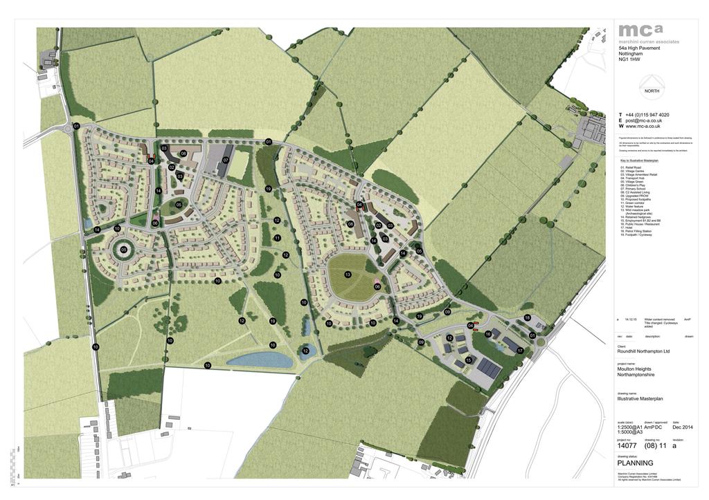
3 : 4 Visual Impact; 5 Ecology; 6 Arboriculture; 7 Water Management; 8 Noise; 9 Air Quality; 10 Cultural Heritage and Archaeology; 11 Ground Conditions; and 12 Cumulative Effects The Site The application site extends to an area of circa 66 ha and is located to the north of the village of Moulton, approximately 7km north-east of Northampton town centre. The site is bound by Holcot Road to the west; agricultural fields to the north; the A43 to the east; and a mixture of agricultural fields and industrial units to the south, beyond which lies residential development. The site comprises mainly agricultural fields in use for arable farming, with some small areas of woodland. A watercourse runs close to the southern border of the site, and a small area of land within the immediate vicinity of the watercourse is designated as Flood Zone 3. The remainder of the site lies within Flood Zone 1. The site does not fall within designated greenbelt and does not contain any listed buildings or scheduled monuments. It does not contain any statutorily designated environmental sites. The Planning Application Proposals Description of the Proposed Development 1.11 The ES assesses an outline planning application for development of up to 1,000 residential dwellings, including accommodation for the elderly, local and community services and facilities, development of a local relief road, mixed use development adjacent to the A43, access, infrastructure, open space, landscaping and associated works. All matters (appearance; layout; scale; landscaping and means of access) are reserved for future consideration by the Council. Layout 1.12 The final layout details for the site will be the subject of a future application for Reserved Matters approval. The parameters plan and illustrative masterplan
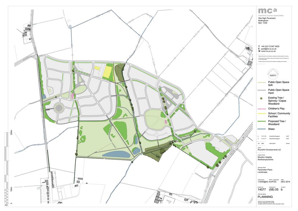
4 Moulton Heights : Non-Technical Summary (included at Appendices B2 and B3 of the ES and in part at Section 14.0 of this document) specify the development framework relating to land use, including the development envelopes at the site, key access routes and open spaces within the site. Scale 1.13 The maximum heights indicated in Table 1.1 have been assessed within the ES, and the scale parameters for residential dwellings and associated community buildings within the site can be identified as: Table 1.1 Storey Heights (Residential and Non-Residential) Storeys Width (max)* Height (ridge height) (max) 1 13m 9m 12m m 9m 12m 2 24m 11m 12m m 11m 12m Non-residential - 15m - uses** Depth (max) 1.14 * including multiple dwelling blocks ** The precise configuration of the nonresidential buildings is not yet known and the width/depth will be determined at a later date Appearance 1.15 The final appearance details of the development are reserved for future approval or condition discharge. The surrounding context will be central to informing the final character of the site, as well as the appearance of the new homes. Careful analysis of the local vernacular will result in the design of new buildings that are well integrated with their surroundings. Landscaping 1.16 For the purposes of this assessment, the parameter plans and indicative masterplan set out the areas of built development and open space (located at Appendices B2 and B3 of the ES). An illustrative landscape strategy has also been prepared which specifies areas of public and natural open space and woodland planting, as well as limited off-site planting. The illustrative landscaping layout is included at Appendix B4 of the ES. Access 1.17 The indicative site masterplan and parameter plans (included at Appendix B3 and B2 respectively) identify access to the site via three points from the existing highway network as follows (though the detailed layout of these are yet to be designed):
5 : 1 Via a new four-armed roundabout junction located on the A43 (primary access point). From this access point, the primary internal link road will generally follow a north-westerly alignment and terminate on the western side of the development, at the current junction of Holcot Road / Boughton Fair Lane; 2 Via a new four-armed roundabout at the existing junction of Holcot Lane / Boughton Fair Lane (secondary access point); and 3 Via a new, bus only access point provided via a new priority junction into the western side of the site from Holcot Road (public transport access point). This route will be open to buses, cyclists and pedestrians only The illustrative site masterplan and parameter plans (included at Appendix B4 and B2 respectively) also indicate introduction of a Green Relief Road through the site, linking from the A43 to Holcot Road. Numerous bus stops are located in proximity to the site on Overstone Road and Holcot Road. These provide hourly services from Northampton to Kettering, as well as intermediate services to villages such as Moulton and Broughton. Sustainability/Energy A commitment to achieving the following sustainability standards is confirmed: 1 Code for Sustainable Homes (CfSH) Level 4 across all new dwellings; and 2 BREEAM rating of Very Good, for all non-residential (commercial) buildings. A high quality of design throughout the development will help to promote respect towards the environment and increase the overall sustainability benefits of the site. The site also occupies an excellent opportunity to facilitate sustainable development and sustainable living through the inclusion of new, local retail services and community facilities within dedicated village centres; the opportunity to design new infrastructure which encourages safe cycling and walking within the site, and to established cycle and walking networks elsewhere that link into the existing walking and cycling network and therefore will offer sustainable connectivity to the wider area; and the provision of new Public Transport Hubs within each village, the commercial development providing local job opportunities accessible by non-car means; and future offsite community uses. Alternatives 1.23 Potential alternatives to the proposed development have been considered in the context of the need for the development, with consideration given to
6 Moulton Heights : Non-Technical Summary progression of the West Northamptonshire Joint Core Strategy (JCS), scheme design evolution and local consultation The land at North Moulton (the application site) was promoted for allocation as a Sustainable Urban Extension (SUE) to accommodate 2,000 dwellings and supporting/ancillary community infrastructure in the West Northamptonshire JCS. The JPU s Strategic Environmental Assessment (SEA) concluded that other sites could accommodate development on land with less landscape quality, and which were directly connected to the urban area of Northampton, and the site was not ultimately allocated. The alternative land to which this application relates has been modified in response to these issues, as well as consultation with statutory stakeholders and the local community, resulting in a substantially reduced scheme of up to 1,000 houses, with development concentrated towards the lower contours of land north of Moulton whilst retaining the buffer landscaping with high connectivity levels between the established Moulton Village and the new development. The Examining Inspector introduced amendments to the proposed Policy R1 of the JCS to ensure sufficient flexibility to allow for development proposals in the rural areas. The alternative proposition now submitted for planning permission meets these policy objectives. In addition to this policy compliance, Daventry District Council is unable to demonstrate a 5-year housing land supply, and there is a demonstrable absence of alternatives to meet this housing shortfall elsewhere. Further, the provision of affordable housing and the housing mix of the development, which responds to local community aspirations, cannot be met elsewhere and is further justification for the application proposals. Consideration has also been given to alternative layouts. The illustrative layout has evolved over a number of years in response to consultation with the local community, statutory consultees, and assessment of technical issues within the ES. Most notably, the masterplan has responded to archaeological finds as these were uncovered, as well as key views to Moulton. Of the alternative layouts considered, the final illustrative masterplan provides the best approach to the delivery of much needed housing and local infrastructure whilst respecting environmental assets and constraints. 2.0 Land Use 2.1 A detailed survey of land use, soils and agricultural land quality has been undertaken. The results show the site to be predominantly in use as arable farmland, all farmed by Overstone Grange Farm, one of the two owners of land at the site. As this farm business would benefit directly from the sale of the land for the proposed development, there are not considered to be any significant adverse effects on farm businesses.
7 : The land was found to have a mixture of soil types, none supporting valuable habitats, but much of the site has a high capacity to absorb excess rainfall. Development therefore has the potential to reduce this capacity and adversely affect local flooding, as well as resulting in the loss of valuable topsoil resources. Mitigation for these potential impacts involves the inclusion of Sustainable Urban Drainage Systems, stripping, stockpiling and reuse of all topsoils and compliance with published good practice guidelines for protection of soils on construction sites. The potential adverse effects of the proposed development on soils with appropriate mitigation are considered minor. Much of the site (50.6 ha) comprises best and most versatile agricultural land, as is common around Northampton. The permanent loss of agricultural land to development cannot be mitigated, and the loss is regarded as a major adverse effect, which are weighed against the benefits of the proposed development in accordance with the National Planning Policy Framework. 3.0 Socio-Economic This chapter considers the potential socio-economic effects of the proposed development, including population structure, employment levels, housing stock and the availability of local services and facilities. The proposals will deliver a substantial residential led mixed-use development comprising of up to 1,000 dwellings on the north-eastern fringe of Northampton within the District of Daventry. The proposed development will provide 7.8% the District s identified annual housing requirement including affordable homes and assisted living units. The proposals will also have important positive economic impacts in Daventry and Northampton and their respective labour markets through the creation of new jobs at both construction and operational stages, along with housing that will increase local labour supply. The scale of housing and population growth resulting from this development will provide important benefits for Daventry and Northampton. The additional resident population generated will be sizeable (estimated at approximately 2,270 people) but its net impact on primary education provision, primary healthcare and other community facilities will be negligible or positive since adequate levels of additional facilities of this type exist in this area or will be provided as part of the development or within other major developments nearby. One potential negative impact of the proposed development would be its impact on secondary school provision but this will be mitigated by the provision of land to the south of site to the local education authority, which is intended to be used for the development of a new secondary school in the future.
8 Moulton Heights : Non-Technical Summary The proposed development would have a negative impact on hospital bed provision across Northampton but this could be mitigated against in conjunction with the local PCT and NHS Trust. Another potential negative impact of the proposed development would be its impact upon outdoor sports facilities and allotment provision. Required facilities cannot be provided on-site due to the topography, but this will be mitigated by financial contributions towards the provision of facilities off-site. The proposals are in compliance with open space requirements and the provision of other amenity and play space within the site exceeds standards. Given that the open space and recreational needs of the new residents would be fully met (and indeed exceeded), and given that the wider Daventry area is deficient in open space provision generally, the proposed development will be of substantial benefit to the local community. The most significant impacts of the proposed development on the local economy would be: 1 A capital investment of approximately million; 2 Provision of up to 1,000 dwelling units within Daventry, of which a significant proportion would be affordable and more would be assisted living units thereby, improving the quality of the housing stock; 3 Some 1,485 person-years of construction work (149 full time employees ( FTE )); direct permanent job opportunities based on the site (487 FTEs), a net additional gain of 438 FTE jobs locally; 5 Provision of retail and education within the site to serve residents; and, 6 Over 26.5ha of open space provision. Overall, the proposed development represents a significant new capital investment in the area and will improve the quality of local housing, and increase population, economic activity and expenditure in the local area without creating significant adverse impacts on existing facilities. It will also provide substantial amounts of new open space, new retail, and a new hotel and petrol filling station to serve the local area. On this basis, there will be no significant adverse socio economic effects, although the provision of housing and employment opportunities will be a significant beneficial effect. 4.0 Transport and Access 4.1 The effect of the proposed development on the surrounding transport network has been assessed, including the potential effects of the predicted traffic associated with the proposed development in the opening and operational phases. In terms of the study area, this has been defined through discussions with Northamptonshire County Council, and includes the following key roads on the surrounding highway network: 1 A43 Kettering Road, North of Sywell Road/Holcot Road
9 : 2 Sywell Road 3 Holcot Road 4 A43 Kettering Road, South of Sywell Road/Holcot Road 5 A43 Kettering Road, North of Overstone Road/Overstone Lane 6 Overstone Road 7 Overstone Lane 8 A43 Park View, South of Overstone Road/Overstone Lane 9 A43 Thorpeville, North of Roundabout 10 Chater Street 11 High Street, West of Chater Street 12 Church Street 13 Cross Street 14 Northampton Lane North 15 The Grove 16 Holcot Road, South of Boughton Fair Lane 17 Boughton Fair Lane 18 Holcot Road, North of Boughton Fair Lane 19 Proposed Link Road An assessment of the developments traffic impact has been undertaken, using the Northampton Strategic Traffic Model (NSTM), for the following scenarios: 2013 (Baseline Assessment Year), 2021 (Opening Forecast Year) and 2026 (Future Forecast Year Full Development). Within this assessment, consideration has also been given to any potential increase in accidents, severance, fear / intimidation and pedestrian delay as well as any potential impacts from dust and dirt during the construction period. In terms of mitigation, in addition to providing vehicular access points on the A43 (primary access point), the junction of Boughton Fair Lane / Holcot Road (secondary access point) and a dedicated Bus-Only access on Holcot Road, the proposals also include to provide a new off-site footway along Holcot Road, and linking the proposed development into the village of Moulton. A Construction Phase Management Plan will also be developed to ensure that any impacts from construction traffic are minimised. This plan will include the provision for wheel wash facilities and road sweeping in order the minimise the impacts from dust and dirt. The assessment has accounted for cumulative impact associated with the proposed development through known committed and allocated development within the vicinity of the site. Confirmation has been provided by NCC that the NSTM, through its forecast years within the traffic model that it accounts for
10 Moulton Heights : Non-Technical Summary committed and allocated development. Hence, the aspect of the cumulative impact has been fully assessed. 5.0 Landscape and Visual Impact There are predicted to be significant adverse landscape effects on the identified landscape receptors during the construction phase of the Moulton Heights development. These receptors include the characteristic landscape patterns and features of the rolling farmland slopes to the north of Moulton and the quality of local views. However, the negative effects associated with construction activities are of a temporary nature and should be set against the long-term major positive effects of the extensive new tree and woodland planting (on-site and off-site), which will knit the new development into the surrounding farmland landscape, retaining and enhancing its predominantly rural character. At a local scale, the characteristic small scale, meadow and woodland landscapes of the lower slopes within the Rolling Ironstone Valley Slopes landscape type will extend further upslope and subtle variations in landscape pattern will more strongly reflect local landform. The contrast in landscape scale will be enhanced, but the transition will be more abrupt. New wetlands will contribute to the diverse character of the upper Page s Brook Valley landscape. Similarly, the significant negative visual effects that are predicted during the construction phase will shift from a negative to a neutral (no perceptible change) or positive impact as the new planting matures. Five years is a relatively short time in the life of a tree and it will typically take years for a native woodland tree belt to provide a full visual screen. There are no predicted outstanding adverse landscape and/or visual effects following completion of the development and the maturation of the new landscape scheme. It would not be appropriate for a new village development on a relatively elevated rural site to be completely enclosed by new woodland planting and the landscape of the new development at Moulton Heights is designed to provide views to and from the residential areas, with new houses partially visible in some locations. The landscape along the A43 corridor will be enhanced to provide a positive gateway to Moulton and the farmland landscape setting on the slopes to the north and east of the village will also be enhanced, with new woodland planting designed to extend and reinforce the existing pattern of woodlands and field hedgerows. Whilst significant cumulative landscape effects are predicted as a result of changes to the rural farmland character of the wider landscape in this part of the Rolling Ironstone Slopes landscape and the erosion of gaps between local villages if the Moulton Heights, Overstone Leys and Overstone Green
11 : developments are implemented together. No significant cumulative visual effects are predicted because the Overstone Leys and Overstone Green development would dominate the gateway views to Moulton and indeed to this part of the Vale of Northampton from the east. In this context, the Moulton Heights development would seem a relatively minor and logical part of this wider development of a sustainable urban extension to Northampton. Overall, the new woodlands, copses and hedgerows (including in particular the extensive off-site woodland planting to be implemented as part of Moulton Heights) would create a stronger sense of enclosure within the immediate landscape setting to Moulton. It would increase the robustness of this landscape and its capacity to absorb the planned new built development associated with the sustainable urban extension (at Overstone Leys/Overstone Green) and the smaller Moulton Heights development. 5.8 Overall the landscape and visual impacts of the new Moulton Heights development are predicted to be positive once the new planting has matured. 6.0 Ecology Chapter G of the ES covers the assessment methodology and the baseline conditions at the site with respect to Ecology. The site was subject to a suite of ecological surveys in 2013 and Specific surveys for bats, Badgers, Otters, water voles, reptiles, Great Crested Newts and birds were undertaken within the site. There are no statutory designated sites of nature conservation interest within the site boundary. The nearest statutory designated site is Crowfields Common LNR which lies 1km to the south of the site. It is not considered that the development proposals would result in any significant effects on statutory designated sites in terms of light, noise, water and air pollution impacts or recreational pressure. Two non-statutory designated sites are located in the surroundings of the site, namely Hog Hole Spinney Local Wildlife Site ( LWS ) (located 0.3km to the south-west) and Cowpasture Spinney LWS (located 0.7km to the east). It is not considered that the development proposals would result in any significant effects on these LWSs in terms of pollution of light, noise, water air or recreational pressure. The nearest Special Protection Area ( SPA ) and Ramsar site is the Upper Nene Gravel Pits SPA / Ramsar site, which is also designated as a SSSI. This SPA / Ramsar site / Site of Special Scientific Interest ( SSSI ) is situated approximately 8.3km to the south-east of the site at its closest point and is separated by significant areas of urban development and agricultural land. Given that the proposed development will include provision of significant areas of informal open space for recreational use, it is considered that the proposed development would not have any effect upon the SPA / Ramsar site / SSSI.
12 Moulton Heights : Non-Technical Summary The majority of the site comprises of arable land with areas of semi-improved grassland present at the boundaries and an improved grassland field present in the east. Hedgerows divide this arable land into a series of fields. The rest of the site comprises of woodland, plantations, a pond and two streams. The vast majority of the habitats present in the site of ecological value will be retained under the development proposals. No mitigation is required for the loss of arable habitats within the site. As for the minor loss of other habitats, the provision, and management of extensive areas of species-rich landscape planting, including new species-rich grassland, trees, a pond and the bolster planting of hedgerow will provide a significant enhancement over the existing situation. As such, there will be no net loss of features of ecological importance. Construction methods of best practice have been proposed throughout this Chapter in order to alleviate any potential adverse impacts on retained habitats. Protected, rare or notable fauna identified within the site includes bats, Badgers and birds. Overall the level of bat activity recorded within the site was generally low. Whilst the proposals will result in minor losses to suitable commuting and foraging habitats, the completed development will provide significant enhancements in the form of species-rich areas of grassland, hedgerow bolster planting and a large pond. Where lighting is necessary during construction and operational phases, light spillage will be reduced and directed away from features that offer suitable foraging opportunities for bats. Bat boxes are to be erected on suitable retained trees to provide additional roosting opportunities for bats. Overall, there will be a significant enhancement in the opportunities for bats across the site. Badger surveys undertaken at the site revealed the presence of two main setts along with other evidence of Badger activity. During the construction phase none of these setts will be lost, however, one may need to be temporarily closed under licence from Natural England depending on its proximity to the development footprint. The requirement for any works under licence will be determined at the detailed application stage. Appropriate measures have been put forward to safeguard Badgers during the construction phase. Considering the enhancement of existing and newly created habitats, opportunities for Badgers across the site would be significantly enhanced within its completed form. The bird surveys identified that the site supports a number of bird species. Only a very small minority of bird habitat will be lost during the construction phase. In any event, clearance of this habitat will be undertaken outside of the bird breeding season (March-July inclusive) where possible. In addition to those key habitats being retained, the provision of species-rich grassland, tree planting and a pond, and the installation of bird boxes, will provide additional
13 : foraging and nesting habitats for birds and will be a significant enhancement over the existing situation Despite two years of survey effort, the reptile surveys did not identify any reptiles within the site itself, however, given that surveys identified reptiles in the wider study area, mitigation is proposed on a precautionary basis during construction to safeguard individuals from harm. The provision of species-rich grassland will provide opportunities for reptiles in the local area and will be a significant enhancement over the existing situation. Specific surveys were undertaken for Otters, Water Voles and Great Crested Newts, however, none of these species were recorded within the site. In any event, it is possible that the site in its completed form will provide novel opportunities for these species. With the implementation of appropriate mitigation, and through the provision of enhancement through the creation and management of habitats, and provision of artificial roosting and nesting features there are predicted to be net benefits for species as a result of the proposed development. Taking into account the potential impacts arising from both the construction and completed development phases and off-setting these, where necessary, with appropriate mitigation, the proposed development complies with relevant planning policies contained within the NPPF and the Daventry District Local Plan 1997 and the emerging West Northamptonshire Joint Core Strategy. In conclusion, all relevant ecological issues have been addressed within this chapter. On the evidence of the specific ecological surveys undertaken, and with the implementation of mitigation and enhancement recommended in this report, the impact of the proposed development upon the natural environment will be an increase in the variety and quality of semi-natural habitat present on site from habitat enhancements, creation and management. 7.0 Arboriculture A pre-development tree and hedgerow survey was undertaken on a 66 hectare parcel of farmland to the north of Moulton in Northamptonshire. The field work was completed in September The survey recorded a total of 39 individual trees (predominantly English Oak and Ash), 10 groups of trees including two small woodlands, and 13 field hedgerows of mixed native species. Of the individual trees approximately two thirds were found to be of moderate or high quality, whilst a similar proportion of the groups were also found to be of moderate or high quality. All but one of the hedgerows was moderate quality, largely because of their wildlife and conservation value. The findings of the survey will be used to ensure that at least all trees and hedgerows of moderate or high quality are incorporated into the design of the
14 Moulton Heights : Non-Technical Summary proposed development, however in some areas there will be small scale losses where sections of hedgerow will need to be removed to allow the construction of access roads. 7.5 An arboricultural impact assessment was subsequently undertaken, based on the proposed master plan, is included as Chapter H of the ES. The conclusion of our assessment was that the overall significance of effects on the arboricultural features of the site will be negligible. 8.0 Water Management The Water Management chapter of the ES considers the potential impacts of the proposed residential-led development on surface water (hydrology), groundwater (hydrogeology) and flood risk of the assessment site. There are three ordinary watercourses within the vicinity of the site and Pitsford Water to the north. A small pond is located within the southern portion of the site. According to the Environment Agency ( EA ), the site is partially underlain by a Secondary A superficial aquifer to the north of the site. The southern half of the site is underlain by a Secondary A bedrock aquifer, while small portions of the northern half of the site are underlain by a Secondary B bedrock aquifer. The EA Flood Map for Planning indicates the majority of the site is located in Flood Zone 1, with a small portion of land adjacent to Moulton Brook to the south of the site located in Flood Zone 3. The risk of groundwater flooding varies across the site due to topography and underlying soil/ground conditions. The risk of flooding from surface water is predominantly low very; however, areas adjacent to Moulton Brook and a small unnamed watercourse (referred to as Trib01) are indicated to be at a high risk of flooding from this source. However, the site is shown to slope from north to south and towards on-site watercourses. As such, the risk of flooding from groundwater and surface water would not be expected to accumulate to any significant depth at the site itself. No water quality data is available for watercourses within 1 km of the site. However, the overall ecological status of Pitsford Water is assessed as Moderate, whilst the underlying groundwater body is assessed to have a good overall status. Potential effects that could occur through the construction and operational phases of the proposed development have been assessed. These include effects on surface water runoff (including its quality); risk of pollution to water bodies and groundwater from contaminants, accidental spillages, suspended sediments and foul water; existing land drainage regimes; and impacts on flood risk from increased impermeable areas and the build up of debris and/or rubbish in drainage ditches. The likely effects of the proposed development during the construction and operational phases of the development have the potential to result in water
15 : environmental impacts of moderate significance. Such impacts may however, be mitigated by a range of operational, control and monitoring measures capable of control through the imposition of suitably worded planning conditions Mitigation measures include the adoption of best practice construction methods and construction management processes; an Environmental Management System; foul water sealed storage vessels that are to be disposed of off-site; raised finished floor levels of residential dwellings; bridge design; water body maintenance; and a surface water drainage scheme. The assessment has demonstrated that the effects during the construction and operational phases following the application of the identified mitigation measures on hydrology and flood risk will be minimal, with environmental impacts on the water environment considered to be not significant. 9.0 Noise An EIA has been undertaken to assess the potential noise impacts of the proposed development. In relation to the requirements of the 2011 Regulations, the aspects of the environment which may be significantly affected include human beings and material assets as follows: 1 Potential impact of the construction noise of the proposed development on existing noise sensitive receptors. 2 Potential impact of the road traffic noise generated by the proposed development on existing noise sensitive receptors. 3 Potential impact of the fixed plant and equipment noise generated by the proposed mixed use development (adjacent to the A43 Kettering Road) on existing noise sensitive receptors. On the basis of an assessment using significance criteria, the potential noise impacts were identified as being negligible using recognised acoustic guidance, standards and target criteria. Notwithstanding this, mitigation measures by means of suitably worded planning conditions have been identified to control potential noise impacts. The residual noise effects associated with the proposed development are considered to be negligible Air Quality 10.1 An air quality assessment has been undertaken which considers the potential effects of dust and fine particulate matter (PM 10 ) emissions from the construction phase of works and the potential air quality effects of additional
16 Moulton Heights : Non-Technical Summary road traffic associated with the operational phase of the development. The air quality assessment has considered air quality at twelve representative existing sensitive receptor locations, all of which are considered to be moderately sensitive The risk of dust soiling effects is considered to be low for earthworks, construction and trackout. The risk of human health effects is classed as low for earthworks, construction and trackout. With the site specific mitigation measures in place, as detailed in section K6.0 of this ES chapter, the significance of dust and fine particulate effects for earthworks, construction activities and trackout are considered to have a minor adverse impact. The air quality assessment predicts that there will be a minor adverse, minor beneficial or neutral impact on concentrations of nitrogen dioxide (NO 2 ) and PM 10 at the twelve existing sensitive receptors considered, in 2021 and It may however be possible to further reduce the impact with the implementation of various mitigation strategies. When taking account of the future development to the south, i.e. the future secondary school and leisure centre, the assessment predicts that there will be a minor adverse impact on concentrations of NO 2 and PM 10 at the twelve existing sensitive receptors considered. It should be noted that the future development is not included within the planning application for the proposed development. All predicted NO 2 and PM 10 concentrations are well below the objective/limit values in the air quality assessment for 2021 and NO 2 and PM 10 concentrations are predicted to be well below the respective annual mean air quality objectives at the three proposed sensitive receptor locations, for all scenarios considered. Measures to mitigate air quality on site are not therefore required Cultural Heritage and Archaeology Consultation with the Northamptonshire Historic Environment indicated a potential for the presence of buried archaeological remains within the boundary of the site. As a consequence of this, a geophysical survey of the entire site and a trial trenching evaluation equating to approximately 1% of the site has been undertaken at the predetermination stage to inform on the potential impact to buried archaeological remains. Both these surveys extended outside of the finalised site boundary and identified focal locations of activity within and outside of the site boundary. Consequently, the results of the predetermination fieldwork guided the outline master plan such that the most extensive and important archaeological remains identified are located either partially or wholly outside of the site boundary or within areas of proposed green space some of which has been
17 : specifically earmarked as a wild meadow. The potential impact to the most important buried remains has therefore been removed or minimised. In respect of other buried remains located within areas of proposed built development, there is no evidence to indicate the presence of remains of greater than medium importance. Furthermore, the likelihood of the presence of further, as yet unknown remains, of greater than local importance is, as a consequence of the effectiveness of the geophysical survey, considered low. As such it is anticipated that further work at the predetermination stage for outline consent would not be required. Rather, a suitable mitigation strategy could be established through consultation with the Development Control Archaeologist Ground Conditions The assessment of ground conditions impacts was informed by a desk study for the wider site area which included a review of site history and available historical boreholes in the surrounding area. Ground conditions underlying the site have been confirmed to consist of Glacial Sand and Gravel and Glacial Till (Granular and Cohesive superficial strata) overlying bedrock of the Stamford Member (formerly the Lower Estuarine Series), with localised areas of Rutland Formation (part of the Great Oolite Group) in the northwest of the site and the Northampton Sand Formation (part of the Jurassic Inferior Oolite Group) along the southern. Made Ground (material deposited or disturbed by man) may also present overlying the superficial glacial deposits. Localised groundwater is likely to be present within the superficial deposits with the main groundwater body within the bedrock strata. Potential sources of contamination on site include farming machinery (potential for fuel/oil leaks from vehicles) and the presence of Made Ground. The degree of contamination arising from previous land uses is typically a function of previous site practices, operational procedures and the degree/condition of any hardstandings that may have been in place at the time. The assessment of impacts has focussed on the suitability of the site for the proposed land uses as well as the health and safety of construction workers. Based on available information, the potential pollutants which may be encountered at the site are not considered to pose any significant risks to current users of the site. Neither are they considered to pose any significant risks to future users of the proposed development, providing suitable mitigation measures are undertaken and any hot spots which may be identified during the scheme specific ground investigation or construction works are removed. This may include provision of appropriate clean cover in proposed soft landscaping areas. Impacts associated with ground gas such as methane or carbon dioxide, if any, will be mitigated by the provision of appropriate gas protection measures in accordance with best practice guidelines.
18 Moulton Heights : Non-Technical Summary The site is considered to be suitable for residential and commercial use with appropriate minor mitigation measures. Based on available information, the potential pollutants which may be in the soils on site are considered to pose a minor risk to human receptors and their property during construction, assuming appropriate health and safety controls are implemented. In general, the use of mitigation measures such as standard construction procedures (bunding of fuel storage areas, avoiding the stockpiling of contaminated material etc) means that the risks to groundwater during the construction and operational stages can be considered to be minor to negligible. Health impacts associated with the inhalation of ground gases, if any, will be mitigated by the provision of appropriate gas protection measures in accordance with best practice guidelines. With all mitigation measures in place no significant impacts to human health or environmental receptors are expected to arise from the ground conditions at the site Cumulative Effects 13.1 The table below reviews whether the inter-relationship between effects arising from the development may give rise to additional impacts not previously identified. It also considers whether effects may arise when the development is considered alongside other schemes or proposals in the surrounding area, the likelihood of the other developments proceeding and the ability or necessity of the applicant to mitigate any such effects for those other sites. Table 13.1 Environmental Topic Effects During Effects during Operation Construction Land Use Major adverse to beneficial Major adverse to beneficial Socio-Economic Moderate positive Minor to moderate positive Transport No impacts Minor negative Landscape and Visual Temporary adverse Positive Impact Ecology No impacts Minor to moderate beneficial Arboriculture No impacts Beneficial Water Management No impacts No impacts Noise No impacts No impacts Air Quality Minor adverse Minor adverse to minor beneficial Cultural Heritage and No impacts No impacts Archaeology Ground Conditions No impacts No impacts
19 : A range of mitigation measures have been identified throughout the ES which are capable of being enforced through planning conditions or a s106 Legal Agreement in relation to the development. Some negative residual effects remain in relation to specific sensitive receptors in relation to farmland, transport, air quality and landscape and visual in certain locations. However, these must be balanced against the significant beneficial environmental effects on socio-economics, ecology and, in other locations, landscape and visual impact Availability of Environmental Statement 14.1 The Non Technical Summary ( NTS ) of this ES is available free of charge at Daventry District Council s ( DCC ) Planning Office, or at the NLP office in Leeds. A hard copy of the ES is available for viewing at the Council s offices (Lodge Road, Daventry, NN11 4FP) during normal office hours. Hard copies of the ES can be purchased for 100 with electronic copies purchased for 10 by contacting Suzanne Phillipson at NLP (telephone ). Representations to Daventry District Council should be made in writing to the above and marked for the attention of Steve Ellis Key Scheme Plans 15.1 Please see scheme plans attached.
20 Moulton Heights : Non-Technical Summary Appendix 1 Appendix 2 Site Location (Red Line) Plan Illustrative Site Masterplan
21
22
23 Moulton Heights : Non-Technical Summary Appendix 3 Key Parameter Plans (detailing access, density, landscape)
24
25
26
University Park, Worcester Non Technical Summary December 2011
 University Park, Worcester Non Technical Summary December 2011 Introduction UW Wrenbridge LLP, a Joint Venture Company of the University of Worcester and Wrenbridge Land Ltd (the Applicants ) intend to
ABBEY MANOR GROUP/SAINSBURY S SUPERMARKETS LTD
 ABBEY MANOR GROUP/SAINSBURY S SUPERMARKETS LTD Mixed Use Development including Business Park and Foodstore Land at Bunford Park, Bunford Lane, Yeovil Environmental Statement: Non-Technical Report June
Grantham Southern Quadrant Link Road Environmental Statement
 Grantham Southern Quadrant Link Road Environmental Statement Non Technical Summary Introduction Lincolnshire County Council (LCC) is submitting a planning application for the proposed implementation of
BREEDON NORTHERN LIMITED
 Non Technical Summary CONTENTS 1 INTRODUCTION... 1 2 SITE DESCRIPTION... 1 3 DESCRIPTION OF THE DEVELOPMENT... 6 4 NEED FOR THE DEVELOPMENT... 8 5 KEY ISSUES CONSIDERED IN THE ENVIRONMENTAL IMPACT ASSESSMENT...
Welcome to our exhibition
 Welcome to our exhibition The Homes & Communities Agency (HCA) welcomes you to this public exhibition explaining our proposals for the redevelopment of the former Lea Castle Hospital site. About the Homes
Statement of Community Involvement LAND OFF SOUTHDOWN ROAD HORNDEAN, HAMPSHIRE
 LAND OFF SOUTHDOWN ROAD HORNDEAN, HAMPSHIRE CONTENTS Page 1. Introduction 3 2. Pre-application Discussions 4 3. The Consultation Process 5 4. Consultation Feedback 7 5. Responses to Consultation Feedback
LAND AT HOWES LANE, BICESTER ENVIRONMENTAL STATEMENT NON-TECHNICAL SUMMARY. March 2017 Our Ref: Q70433
 LAND AT HOWES LANE, BICESTER ENVIRONMENTAL STATEMENT NON-TECHNICAL SUMMARY March 2017 Our Ref: Q70433 Contents 1 INTRODUCTION AND SITE DESCRIPTION... 1 2 EIA METHODOLOGY... 5 3 ALTERNATIVES... 6 4 DESCRIPTION
Newcourt Masterplan. November Exeter Local Development Framework
 Newcourt Masterplan November 2010 Exeter Local Development Framework Background The Exeter Core Strategy Proposed Submission sets out the vision, objectives and strategy for the development of Exeter up
Replacement Golf Course Facilities and Residential Development, Churston. Environmental Statement Non-Technical Summary
 Replacement Golf Course Facilities and Residential Development, Churston Environmental Statement Non-Technical Summary July 2011 Reproduced from the Ordnance Survey s map with the permission of the Controller
Longbridge Town Centre Phase 2 Planning Application
 Longbridge Town Centre Phase 2 Planning Application Non-Technical Summary of the Environmental Statement December 2013 Introduction A full application for Planning Permission has been submitted to Birmingham
South Whitehaven, Cumbria EIA
 South Whitehaven, Cumbria EIA Environmental Statement - Non Technical Summary June 2013 in association with 1. Introduction Story Homes is applying to Copeland Borough Council (CBC) for a new residential
LAND AT MIDDLETON STONEY ROAD AND HOWES LANE, BICESTER ENVIRONMENTAL STATEMENT NON-TECHNICAL SUMMARY. June 2017 Our Ref: Q70433
 LAND AT MIDDLETON STONEY ROAD AND HOWES LANE, BICESTER ENVIRONMENTAL STATEMENT NON-TECHNICAL SUMMARY June 2017 Our Ref: Q70433 Contents 1 INTRODUCTION... 2 2 SITE DESCRIPTION... 5 3 EIA METHODOLOGY...
NON-TECHNICAL SUMMARY
 Proposed Sand and Gravel Extraction and Associated Processing Operations with Restoration to a Mixture of Agriculture and Nature Conservation including Areas of Shallow Water at Hedgeley, Northumberland
Cranbrook EXPANSION ENVIRONMENTAL STATEMENT: NON-TECHNICAL SUMMARY PRODUCED BY DAVID LOCK ASSOCIATES
 Cranbrook EXPANSION ENVIRONMENTAL STATEMENT: NON-TECHNICAL SUMMARY PRODUCED BY DECEMBER 2014 CRANBROOK EXPANSION AREAS ENVIRONMENTAL STATEMENT NON TECHNICAL SUMMARY Submitted in support of Outline Planning
Moat Lane Regeneration Project Environmental Statement
 AECOM Environment Towcester Regeneration Ltd. October 2012 Moat Lane Regeneration Project Environmental Statement Non-Technical Summary Prepared by:... Checked by:... Sophie Collins Scott Wilson Environmental
VALLEY PARK, DIDCOT. Non-Technical Summary. December On behalf of Taylor Wimpey UK Limited, Persimmon Homes and Hallam Land Management Ltd.
 VALLEY PARK, DIDCOT Non-Technical Summary December 2014 On behalf of Taylor Wimpey UK Limited, Persimmon Homes and Hallam Land Management Ltd. CONTENTS 1 Introduction... 2 2 The Proposed Development...
LAND SECURITIES REDEVELOPMENT OF NEWNHAM COURT SHOPPING VILLAGE, MAIDSTONE
 LAND SECURITIES REDEVELOPMENT OF NEWNHAM COURT SHOPPING VILLAGE, MAIDSTONE Land at Environmental Statement: Non-Technical Summary Introduction Land Securities plc is applying to Maidstone Borough Council
LAND AT WEST YELLAND. Environmental Statement Non-Technical Summary Welbeck Strategic Land LLP
 LAND AT WEST YELLAND Environmental Statement Non-Technical Summary Welbeck Strategic Land LLP May 2014 Quality Management Issue/revision Issue 1 Revision 1 Revision 2 Revision 3 Remarks Draft FINAL Date
Sustainability Statement. Whitby Business Park Area Action Plan
 Sustainability Statement Whitby Business Park Area Action Plan November 2014 Contents Page 1. Introduction 1 2. Scoping 3 3. Sustainability Appraisal of Options 6 4. Assessment of Draft Area Action Plan
SPG 1. * the northern and western sections which are open fields used for pasture and grazing;
 SPG 1 1.0 INTRODUCTION This development brief is based on the allocation of the Priors Hall site for employment and countryside recreational purposes in the Corby Borough Local Plan. The brief is intended
Frequently Asked Questions
 1. Where is Aylesbury Woodlands? Frequently Asked Questions Aylesbury Woodlands lies to the east of Aylesbury. It is bounded to the south by the A41. To the north is the Aylesbury Arm of the Grand Union
Kilnw Envir ood Vale onmental Statement Volume 3: Non Technical Summary July 2010
 Kilnwood Vale Environmental Statement Volume 3: Non Technical Summary July 2010 Kilnwood Vale Environmental Impact Assessment Environmental Statement Volume 3 KILNWOOD VALE ENVIRONMENTAL STATEMENT NON-TECHNICAL
LAND NORTH OF NETHERHOUSE COPSE, FLEET
 REPORT N O 70020067 LAND NORTH OF NETHERHOUSE COPSE, FLEET ENVIRONMENTAL STATEMENT VOLUME 3:NON-TECHNICAL SUMMARY OF THE ENVIRONMENTAL STATEMENT PUBLIC JUNE 2016 LAND NORTH OF NETHERHOUSE COPSE, FLEET
NORTHAMPTON. Overstone Leys. Delivering a New Sustainable Urban Extension for Northampton. Progress Report March 2013
 Overstone Leys NORTHAMPTON Delivering a New Sustainable Urban Extension for Northampton Progress Report March 2013 Prepared by Pegasus Group Barratt Developments 18.03.13 EMS.2089 _27 A Contents 1. Background
Land at BROOK STREET PROPERTIES TENCREEK FARM, LISKEARD. Environmental Statement: Non-Technical Summary
 BROOK STREET PROPERTIES TENCREEK FARM, LISKEARD Land at Environmental Statement: Non-Technical Summary Introduction Brook Street Properties is applying to Cornwall Council for outline planning permission
The Trustees of the Standen Estate Land South of Clitheroe Non-Technical Summary
 1 The Trustees of the Standen Estate Land South of Clitheroe Non-Technical Summary 1. Introduction This report summarises the results of an assessment that has been undertaken to determine how a proposed
Site ref: AS06 Site Name or Address: Murreys Court, Agates Lane
 Site ref: AS06 Site Name or Address: Murreys Court, Agates Lane Proposed Land Use: Total Site Area (Ha): Housing 1.85 Ha Description: It is understood that the owner has no plans to dispose of the site
WELCOME. Land North of STEVENAGE. We would like to thank you for attending our public exhibition today.
 WELCOME We would like to thank you for attending our public exhibition today. The purpose of this event is to share our proposals and hear your thoughts on our ideas. Members of the project team are on
Cardiff International Sports Village Waterfront Development Volume IV : Non-Technical Summary of the Environmental Statement
 Greenbank Partnerships Ltd October 2012 Cardiff International Sports Village Waterfront Development Volume IV : Non-Technical Summary of the Environmental Statement Environmental Statement - Non Technical
Public Consultation. Land at Monks Farm, North Grove. Welcome
 Welcome Welcome to our public exhibition for development on Land at Monks Farm, orth Grove. Gallagher Estates and Gleeson Strategic Land are preparing an outline planning application for new homes, open
WELCOME GYPSY LANE. Wider Site Location plan. Proposals for the development of LAND OFF FOXLYDIATE LANE WEBHEATH. Proposals for the development of
 WELCOME The developers are preparing an outline planning application for a residential led development and need the community s views in order to develop the proposals further WHAT IS PROPOSED? A high
Neighbourhood Planning Site Assessment Pro-forma and Guide Version 2
 Neighbourhood Planning Site Assessment Pro-forma and Guide Version 2 September 2014 Site HNP 006 Land East of Stanbridge Road and North of Lower Road 1. Background information Site location and use Site
Re-location of Rugby Farmers Mart
 Re-location of Rugby Farmers Mart LaSalle Investment Management Barberry Logo here Environmental Statement Non-Technical Summary August 2017 Re-location of Rugby Farmers Mart Non-Technical Summary Report
SOUTH EAST LINCOLNSHIRE LOCAL PLAN: HOUSING PAPER DONINGTON (JUNE 2016)
") SOUTH EAST LINCOLNSHIRE LOCAL PLAN: HOUSING PAPER DONINGTON (JUNE 2016) 1 DONINGTON S PLACE IN THE SPATIAL STRATEGY 1.1 Policy 2 of the South East Lincolnshire Local Plan 2011-2036 Draft for Public Consultation
SOUTH EAST LINCOLNSHIRE LOCAL PLAN: HOUSING PAPER DONINGTON (JUNE 2016) 1 DONINGTON S PLACE IN THE SPATIAL STRATEGY 1.1 Policy 2 of the South East Lincolnshire Local Plan 2011-2036 Draft for Public Consultation
NON-TECHNICAL SUMMARY
 NON-TECHNICAL SUMMARY THE HIDE, BISHOP AUCKLAND PROPOSED ECO CHALET DEVELOPMENT NON-TECHNICAL SUMMARY 1 Introduction 1.1.1 This non-technical summary for the (ES) prepared in relation to the proposed eco-chalet
17A. Wind Microclimate
 17A. Wind Microclimate 17A.1 Introduction 17A.1.1 17A.1.2 17A.1.3 17A.1.4 This Chapter, which has been prepared by Waterman and BMT, provides further information with regard to the potential wind microclimate
Follingsby Park South Environmental Statement: Volume 1: Non Technical Summary (March 2018)
") Follingsby Park South Environmental Statement: Volume 1: Non Technical Summary (March 2018) 1.0 Introduction and Methodology 1.1 This document is a summary in non-technical language of an Environmental
Follingsby Park South Environmental Statement: Volume 1: Non Technical Summary (March 2018) 1.0 Introduction and Methodology 1.1 This document is a summary in non-technical language of an Environmental
Rochford District Council Allocations Development Plan Document: Discussion and Consultation Document Sustainability Appraisal
 Option SWH1 Balanced Communities Option SWH1 1 To ensure the delivery of high quality sustainable communities where people want to live and work Will it ensure the phasing of infrastructure, including
PERSIMMON HOMES (SW) LIMITED LAND AT ADDINGTON, LISKEARD ENVIRONMENTAL STATEMENT NON-TECHNICAL SUMMARY
 LIMITED LAND AT ADDINGTON, LISKEARD ENVIRONMENTAL STATEMENT NON-TECHNICAL SUMMARY") PERSIMMON HOMES (SW) LIMITED LAND AT ADDINGTON, LISKEARD ENVIRONMENTAL STATEMENT NON-TECHNICAL SUMMARY APRIL 2010 INTRODUCTION This document is the Non-Technical Summary (NTS) of an Environmental Statement
PERSIMMON HOMES (SW) LIMITED LAND AT ADDINGTON, LISKEARD ENVIRONMENTAL STATEMENT NON-TECHNICAL SUMMARY APRIL 2010 INTRODUCTION This document is the Non-Technical Summary (NTS) of an Environmental Statement
The Place Solar Farm
 The Place Solar Farm Environmental Statement Non-Technical Summary 28 August 2014 Produced for Prepared by St John s House Queen Street, Manchester M2 5JB Contents Contents... 2 1 Introduction... 3 1.1
LAND WEST OF ST ANDREWS ROAD
 LAND WEST OF ST ANDREWS ROAD ENVIRONMENTAL STATEMENT VOLUME 3 - NON-TECHNICAL SUMMARY Submitted by Nathaniel Lichfield & Partners on behalf of Redrow Homes Limited July 2014 Applicant: Consultant Team:
Meridian Water Phase 1 Application
 Meridian Water Phase 1 Application MW11 Environmental Statement Non-Technical Summary London Borough of Enfield March 2016 Contents 1 Introduction 1 2 The proposed development 2 3 Evolution of the proposed
Ref: A073350/SM/sm Date: 13 September 2013
 Ref: A073350/SM/sm Date: 13 September 2013 Ian Parkinson Development Control Team Leader Planning Portsmouth City Council Civic Offices Guildhall Square Portsmouth PO1 2AY Dear Ian LIGHT & GLEAVE VILLA
Welcome. Site/11/04. Site/11/03. Proposed Site. 11,400 new homes needed in east Cambs
 Welcome Welcome to our consultation on our proposals for new homes on land north east of Soham Road, Fordham. Members of the project team are available to answer any questions you have and listen to feedback.
Wyvern Park Skipton Environmental Statement. Non-technical Summary - April 2015
 Wyvern Park Skipton Environmental Statement Non-technical Summary - April 2015 BWB Consulting Ltd Whitehall Waterfront 2 Riverside Way Leeds LS1 4EH Telephone: +44(0)113 233 8000 Copyright This Report
Former RAF Sealand Site EIA
 Praxis (Holdings) Ltd. Former RAF Sealand Site EIA Environmental Statement - Non Technical Summary February 2012 in association with P a g e 1 1. Introduction Praxis (Holdings) Ltd. is applying to Flintshire
London Road, Derker. Non Technical Summary. Introduction
 London Road, Derker Non Technical Summary Introduction The Oldham Rochdale Housing Market Pathfinder was set up to tackle longstanding problems of poor quality housing and to provide the framework for
South Macclesfield Development Area Environmental Statement Non-Technical Summary March 2017
 South Macclesfield Development Area Environmental Statement March 2017 Contents 1.0 Introduction... 2 1.1 Background... 2 1.2 Environmental Assessment... 2 1.3 Site Description... 2 2.0 The Proposals...
WHITELEY TOWN COUNCIL NORTH WHITELEY DEVELOPMENT SEPTEMBER 2014
 WHITELEY TOWN COUNCIL NORTH WHITELEY DEVELOPMENT SEPTEMBER 2014 Dear Resident This Special Edition of the Whiteley Voice which has been prepared in conjunction with the North Whiteley Consortium is to
Causeway Farm, Petersfield Environmental Statement Non-Technical Summary October 2015
 Causeway Farm, Petersfield Environmental Statement October 2015 2 Contents 1.0 Introduction... 1 1.1 Background... 1 1.2 Environmental Assessment... 1 1.3 Site Description... 3 2.0 The Proposals... 6 2.1
Plumpton Neighbourhood Development Plan Revised Pre Submission Document - Regulation 14 Consultation
 REPRESENTATIONS... Plumpton Parish Council Plumpton Neighbourhood Development Plan Revised Pre Submission Document - Regulation 14 Consultation Representations submitted on behalf of: Cala Homes (South
Chapter 2: OUTLINE PLANNING APPLICATION PROPOSALS. A New Garden Neighbourhood Matford Barton 17
 Chapter 2: OUTLINE PLANNING APPLICATION PROPOSALS A New Garden Neighbourhood Matford Barton 17 2.1. SUMMARY AND STATUS OF THE PROPOSALS 2.1.1. The parameter plans and associated wording in this chapter
NON-TECHNICAL SUMMARY
 Hybrid outline/detailed planning application comprising an outline planning application for 196 residential dwellings, landscaping, open space, estate roads and infrastructure, plus 4 permanent gypsy and
Welcome to our Public Consultation
 About our development This exhibition gives you the chance to view and comment on our emerging plans for a proposed residential development located on land to the West of Alwyn Road, Rugby. Welcome to
3.1 The hybrid planning application proposes the following description of development:
 CHAPTER 3: PROPOSED DEVELOPMENT 3.1 The hybrid planning application proposes the following description of development: Hybrid (part-outline/part-full) planning application for a single composite development
MAIDSTONE MEDICAL CAMPUS LTD LAND AT NEWNHAM PARK, MAIDSTONE
 MAIDSTONE MEDICAL CAMPUS LTD LAND AT NEWNHAM PARK, MAIDSTONE Land at Environmental Statement: Non-Technical Summary Introduction Maidstone Medical Campus Ltd is applying to Maidstone Borough Council for
The Town and Country Planning (Environmental Impact Assessment) (Wales) Regulations 2016, Regulation 13 Scoping Opinion
 (Wales) Regulations 2016, Regulation 13 Scoping Opinion") Mr Graham Clark Berrys Newchurch Farm Kinnersley Hereford HR3 6QQ BY EMAIL The Town and Country Planning (Environmental Impact Assessment) (Wales) Regulations 2016, Regulation 13 Scoping Opinion SC/2017/0001
Mr Graham Clark Berrys Newchurch Farm Kinnersley Hereford HR3 6QQ BY EMAIL The Town and Country Planning (Environmental Impact Assessment) (Wales) Regulations 2016, Regulation 13 Scoping Opinion SC/2017/0001
Comments on the proposed scope are requested from WCC/NBBC officers to be provided to SLC Rail by 25 th March 2016 and sent to
 Introduction WCC have indicated that in advance of the surveys and assessments being undertaken consultation should be undertaken with technical officers of both Warwickshire CC and Nuneaton and Bedworth
Kibworth Harcourt. Introduction. Introduction
 Introduction Introduction Welcome to this public exhibition on the proposals for the delivery of new homes on land at The Kibworths. The purpose of today s exhibition is to give you the opportunity to
Ʊ ± ªº Œª ºª ø ª ª ± ª
 Ʊ ± ªº Œª ºª ø ª ª ± ª ø º Õ± ± ± Œ±øºÙ Õ ß Æª ø檺 ±Æ ƪ ø檺 æß Æ± Ʊ ª ø ø fl ª ª ± ê ø Õ øæß ª ª æªæ Ó ÔÌ Non-Technical Summary Introduction A planning application has been submitted to the Vale
DESIGN & ACCESS STATEMENT
 DESIGN & ACCESS STATEMENT January 2016 Contents Introduction section 1 Section 1 - Introduction Section 2 - Assessment Section 3 - Involvement Section 4 - Evaluation Section 5 - Design Section 6 - Layout
Site Assessment Technical Document Appendix A: Glossary
 Central Bedfordshire Council www.centralbedfordshire.gov.uk Site Assessment Technical Document Appendix A: Glossary July 2017 1.1.11-1 - ii Appendix A: Glossary Term Agricultural Land Classification AONB
Elvetham Chase, Fleet. Environmental Statement: Non-Technical Summary. November New Fetter Lane London EC4A 1AZ United Kingdom
 Elvetham Chase, Fleet Environmental Statement: Non-Technical Summary November 2016 A Ne w F e tte r P lace 8-10 New Fetter Lane London EC4A 1AZ United Kingdom T +44 (0) 20 7467 1470 F +44 (0) 20 7467 1471
Policy DM19: Development and Nature Conservation
 Avonmouth Wetland Habitat Project October 2010 and December 2011 (the Cresswell study). Policy Links Bristol Local Plan Core Strategy Lead Policy BCS4: Avonmouth and Bristol Port BCS9: Green Infrastructure
Unity Square, Nottingham Environmental Statement Non Technical Summary December 2013
 Unity Square, Nottingham Environmental Statement Non Technical Summary December 2013 in association with 1. Introduction Peel Holdings is applying to Nottingham City Council (NCC) for Outline planning
Welcome to our exhibition
 Welcome to our exhibition housing development A46 Wildmoor Alcester Road Canal Quarter A422 Town Centre housing development Warwickshire-based IM Properties, one of the UK s largest privately owned property
Peter Brett Associates LLP (PBA) act on behalf of db symmetry ltd in respect of the proposed symmetry park, Kettering development (the Site).
 act on behalf of db symmetry ltd in respect of the proposed symmetry park, Kettering development (the Site).") Our ref: 30062 2 nd August 2017 Kettering Borough Council Planning Department Municipal Offices Bowling Green Rd Kettering NN15 7QX 61 Oxford Street Manchester M1 6EQ T: +44 (0)161 245 8900 E: manchester@peterbrett.com
Our ref: 30062 2 nd August 2017 Kettering Borough Council Planning Department Municipal Offices Bowling Green Rd Kettering NN15 7QX 61 Oxford Street Manchester M1 6EQ T: +44 (0)161 245 8900 E: manchester@peterbrett.com
Lower Herne Village Hollamby Estates (2005) Ltd Environmental Statement Non-Technical Summary June 2015 INSERT PICTURE HERE
 Ltd Environmental Statement Non-Technical Summary June 2015 INSERT PICTURE HERE") Environmental Statement Non-Technical Summary June 2015 INSERT PICTURE HERE Table of Contents 1 INTRODUCTION 1 2 SITE LOCATION AND PROPOSED DEVELOPMENT 3 3 THE ASSESSMENT 8 4 CONCLUSIONS 16 5 WHAT HAPPENS
Environmental Statement Non-Technical Summary June 2015 INSERT PICTURE HERE Table of Contents 1 INTRODUCTION 1 2 SITE LOCATION AND PROPOSED DEVELOPMENT 3 3 THE ASSESSMENT 8 4 CONCLUSIONS 16 5 WHAT HAPPENS
BRIDGE OF DON MASTERPLAN & PLANNING SUMMARY
 BRIDGE OF DON MASTERPLAN & PLANNING SUMMARY SITE LOCATION The site of the existing AECC lies in an area of predominately residential and business use in Bridge of Don and extends approximately 50 acres.
PINEWOODS HOLIDAY PARK: HORSE PADDOCK. Non-Technical Summary
 PINEWOODS HOLIDAY PARK: HORSE PADDOCK June 2014 1 Introduction 1.1 The existing Pinewoods Holiday Park is located approximately 1 km to the north of Wells-nextthe-Sea on the north Norfolk coast. Pinewoods
LAND AT PARK MILL FARM, PRINCES RISBOROUGH ENVIRONMENTAL STATEMENT SUPPLEMENT NON-TECHNICAL SUMMARY
 LAND AT PARK MILL FARM, PRINCES RISBOROUGH ENVIRONMENTAL STATEMENT SUPPLEMENT NON-TECHNICAL SUMMARY May 2016 CONTENTS CONTENTS... i 1 Introduction... 1 2 The Proposed Development... 3 3 Need and Alternatives
Oxford Green Belt Study. Summary of Final Report Prepared by LUC October 2015
 Oxford Green Belt Study Summary of Final Report Prepared by LUC October 2015 Project Title: Oxford Green Belt Study Client: Oxfordshire County Council Version Date Version Details Prepared by Checked by
PERRYFIELDS BROMSGROVE. ENVIRONMENTAL STATEMENT - NON-TECHNICAL SUMMARY December 2015
 PERRYFIELDS BROMSGROVE ENVIRONMENTAL STATEMENT - NON-TECHNICAL SUMMARY December 2015 Environmental Statement Non-technical summary CONTENTS 1 Introduction 2 The Site and local context 3 Description of
Land at Weymouth Gateway Proposed hotel and pub / restaurant Non-technical summary. Premier Inns Ltd February 2011
 February 2011 Introduction NTS.1 In April 2007, New Look Retailers Ltd submitted an outline planning application to Weymouth and Portland Borough Council to redevelop the Mount Pleasant Business Park
LONDON BRIDGE STATION ENVIRONMENTAL STATEMENT NON-TECHNICAL SUMMARY
 LONDON BRIDGE STATION ENVIRONMENTAL STATEMENT NON-TECHNICAL SUMMARY June 2011 1 EXECUTIVE SUMMARY 2 INTRODUCTION CONTENTS Page 2.1 Introduction 4 2.2 The Site 4 3 THE DEVELOPMENT 3.1 What is it? 5 3.2
ROCHFORD LOCAL DEVELOPMENT FRAMEWORK: Sustainability Appraisal/ Strategic Environmental Assessment. Rochford Core Strategy Preferred Options Document
 ROCHFORD LOCAL DEVELOPMENT FRAMEWORK: Sustainability Appraisal/ Strategic Environmental Assessment Non Technical Summary Rochford Core Strategy Preferred Options Document October 2008 SUSTAINABILITY APPRAISAL
Chapter 4. Route Window C12: Mile End Park and Eleanor Street Shafts
 Chapter 4 Route Window C12: Mile End Park and Eleanor Street Shafts 48 Crossrail Amendment of Provisions 4 Route Window C12: Mile End Park and Eleanor Street Shafts Location plan of Mile End Park and Eleanor
Inert Recycling (UK) Ltd Boxgrove Quarry Restoration Environmental Statement
 Ltd Boxgrove Quarry Restoration Environmental Statement") November 2013 Non-Technical Summary Empress House, 12 Empress Road, Lyndhurst, SO43 7AE Tel: 023 8028 3226 Email: waste.enquiries@wyg.com Introduction Background EIA is a process by which the environmental
November 2013 Non-Technical Summary Empress House, 12 Empress Road, Lyndhurst, SO43 7AE Tel: 023 8028 3226 Email: waste.enquiries@wyg.com Introduction Background EIA is a process by which the environmental
Salisbury Road, Marlborough. Outline Planning Application Environmental Statement: Non-technical Summary
 Salisbury Road, Marlborough Outline Planning Application Environmental Statement: Non-technical Summary Copyright and Non-Disclosure Notice The contents and layout of this report are subject to copyright
Barvills Solar Farm Environmental Statement Non-Technical Summary
 Barvills Solar Farm Environmental Statement Non-Technical Summary 13 March 2015 Produced for Prepared by St John s House Queen Street, Manchester M2 5JB Contents Contents... 2 1 Introduction... 3 1.1 Development
M4 Corridor around Newport Environmental Statement Volume 3: Appendices
 Environmental Statement Volume 3: Appendices Environmental Statement Volume 3: Appendices At Issue March 2016 CVJV/AAR 3 rd Floor Longross Court, 47 Newport Road, Cardiff CF24 0AD Volume 3: Contents 1
Derry City and Strabane District Council Planning Committee Report. Amended layout from approval A/2004/0462/F with reduction from 166 units
 Derry City and Strabane District Council Planning Committee Report COMMITTEE DATE: 1 st February 2017 APPLICATION No: APPLICATION TYPE: PROPOSAL: LOCATION: APPLICANT: AGENT: Full Planning application Amended
NON TECHNICAL SUMMARY
 NON TECHNICAL SUMMARY INTRODUCTION NTS.1 CEMEX UK Properties Limited is applying for planning permission to South Cambridgeshire District Council (SCDC) for the redevelopment of the former CEMEX cement
Burgess Hill, Land South of Freeks Farm Phase 1 of Burgess Hill Northern Arc East Environmental Statement Non-Technical Summary September 2016
 Burgess Hill, Land South of Freeks Farm Phase 1 of Burgess Hill Northern Arc East Environmental Statement September 2016 Contents 1.0 Introduction... 1 1.1 Background... 1 1.2 Environmental Assessment...
PANSHANGER QUARRY, Hertfordshire
 PANSHANGER QUARRY, Hertfordshire Proposed enhanced restoration of Phases F & H Briefing Note 1 March 2015 INERT (INACTIVE) RESTORATION MATERIALS, CONTROLS AND OPERATIONS 1 Introduction This briefing note
8.0 Design and Form of Development 43/
 42/ 8.0 Design and Form of Development 43/ Rothwells Farm, Golborne/ Development Statement Figure 7. Site Constraints Key 44/ Site Boundary 360 Bus Route/Stops Existing Trees Underground Water Pipe Sensitive
Ipswich Issues and Options for the Ipswich Local Plan Review, August 2017, Public Consultation
 Ipswich Issues and Options for the Ipswich Local Plan Review, August 2017, Public Consultation Having reviewed the issues and options documents, the Society has made the following response: Part 1 Strategic
Land at Rampton Road. Cottenham
 Land at Rampton Road Cottenham Introduction TEP is preparing an outline planning application for 54 dwellings on 6.9 hectares of land adjacent to Rampton Road, Cottenham on behalf of the owners Cambridgeshire
Taylor Wimpey UK Ltd Proposed Development at Haydock Grange, Hoyles Lane, Preston Non-Technical Summary Revision 1 October 2011
 Taylor Wimpey UK Ltd Proposed Development at Haydock Grange, Hoyles Lane, Preston Non-Technical Summary Revision 1 October 2011 Introduction An application for outline planning permission has been submitted
CENTRAL BEDFORDSHIRE COMMITTED TO WORKING TOGETHER WITH LOCAL COMMUNITIES
 WELCOME Thank you for coming to our consultation event to find out more about our emerging proposals for Hayfield Park, a residential development jointly promoted by the Hayfield Consortium: Martin Grant
Buckinghamshire Aylesbury Woodlands Advantage Ltd Aerial View from West
 The proposed Aylesbury Woodlands site is located to the east of Aylesbury and is being promoted by Buckinghamshire Advantage, which is the infrastructure delivery arm of Buckinghamshire Thames Valley Local
Hounsome Fields, Basingstoke Environmental Statement Non- Technical Summary. For Wates Developments Ltd and Pellipar Investments Ltd
 Hounsome Fields, Basingstoke Environmental Statement Non- Technical Summary For Wates Developments Ltd and Pellipar Investments Ltd December 2015 Contents 1 Introduction 3 2 The Proposals 8 3 Environmental
Thornton Road, Pickering Environmental Statement Non-Technical Summary. January 2016
 Thornton Road, Pickering Environmental Statement Non-Technical Summary January 2016 EIA Quality This Environmental Statement, and the Environmental Impact Assessment (EIA) carried out to identify the significant
DEFGH. Crystal Place Park. Environmental Impact Assessment (EIA) Elin Thomas and Emily Low Waterman Environmental
 Elin Thomas and Emily Low Waterman Environmental") DEFGH Crystal Place Park Environmental Impact Assessment (EIA) Elin Thomas and Emily Low Waterman Environmental 10.12.07 EIA Presentation Content What is EIA? Legal Requirements Process Q&A Key Topics
DEFGH Crystal Place Park Environmental Impact Assessment (EIA) Elin Thomas and Emily Low Waterman Environmental 10.12.07 EIA Presentation Content What is EIA? Legal Requirements Process Q&A Key Topics
Environmental Statement (Volume 1) Non Technical Summary
 Non Technical Summary") Environmental Statement (Volume 1) Non Technical Summary Prepared by: The Environment Partnership Haydock Point Environmental Statement (Volume 1): Non-Technical Summary March 2017 Contents 1. Introduction
Environmental Statement (Volume 1) Non Technical Summary Prepared by: The Environment Partnership Haydock Point Environmental Statement (Volume 1): Non-Technical Summary March 2017 Contents 1. Introduction
PHASE III: Reserved Matters Submission
 Statement of Compliance with the outline approval for the proposed residential development of land at: BURGES LANE, WIVELISCOMBE PHASE III: Reserved Matters Submission Foreword Contents: This Statement
Kings Road Industrial Development, Immingham. Environmental Impact Assessment. Non Technical Summary
 Environmental Impact Assessment Non Technical Summary Report prepared by: Ecus Ltd. Brook Holt 3 Blackburn Road Sheffield S61 2DW 0114 266 9292 December 2013 Page left intentionally blank INTRODUCTION
7 Scoping and Introduction to the Assessments
 7 Scoping and Introduction to the Assessments 7.1 Scope of the assessments 7.1.1 Rule 8 of the TWR makes provision for an applicant to request a scoping opinion from the SoS indicating the information
Bloor Homes Stubbocks Walk North Hertfordshire ENVIRONMENTAL STATEMENT NON-TECHNICAL SUMMARY
 Bloor Homes Stubbocks Walk North Hertfordshire ENVIRONMENTAL STATEMENT NON-TECHNICAL SUMMARY December 2016 Environmental Statement: Non-Technical Summary Stubbocks Walk, North Hertfordshire J S Bloor
Introduction. Grounds of Objection
 Planning application ref. number 18/04496/APP Planning application to Aylesbury Vale District Council for the erection of 17 dwellings and associated works to the South of Hogshaw Road Granborough. Granborough