GOODY CLANCY WITH KITTELSON & ASSOCIATES RHODESIDE & HARWELL FARR ASSOCIATES W-ZHA
|
|
|
- Barbara Wood
- 5 years ago
- Views:
Transcription


1 1
2 1. Welcome / Subcommittee introductions, role, goals, Realize Rosslyn process overview 10 min. 2. Existing parks/open space context 10 min. 3. The Rosslyn Plan framework / Parks & open space overview 5 min. 4. Rosslyn park spaces / Overview of types, identities 60 min. 5. The game changers / Details on transformative places 60 min. 6. Next steps 5 min. 2
3 Members of the Subcommittee on Parks and Open Space Paul Holland (Chair) RPP / Park and Rec. Commission (PRC) Katie Elmore RPP / North Rosslyn CA Caroline Haynes PRC / Urban Forestry Commission (UFC) Peter Hage PRC Elizabeth Gearin PRC Karen Kumm Morris Planning Commission / UFC Steve Campbell Radnor/Ft. Myer Heights CA / UFC Jon Hensley Arts Commission / Public Art Committee Mike Novotny Rosslyn Plaza Peter Greenwald Rosslyn BID Sherri Greene Rosslyn BID 3
4 At an important point in the process to formulate detailed recommendations & specific guidance for the challenging implementation of preferred vision Primary goal of subcommittee is to provide input on key questions and issues posed to the group, pertaining to Parks and Open Space component of Rosslyn Sector Plan Update Review information/materials produced by staff/consultant team, generally in advance of meetings (and ask questions where needed!) While general agreement among group would be great goal, full consensus not a requirement - group input will help inform/shape end product Complete work in 2 meetings between September October 4


5 An ongoing community planning effort To develop an Update for the Rosslyn Sector Plan That will refresh the community vision for Rosslyn s future Provide a planning framework and implementation strategies to achieve the that vision
6 Subcommittee work 6


7 Major milestone, foundation for the full Sector Plan Update Comprised of Vision Statement, Principles and Policy Directives Based on analyses, preliminary concepts, and community input 7

8 8


9 9


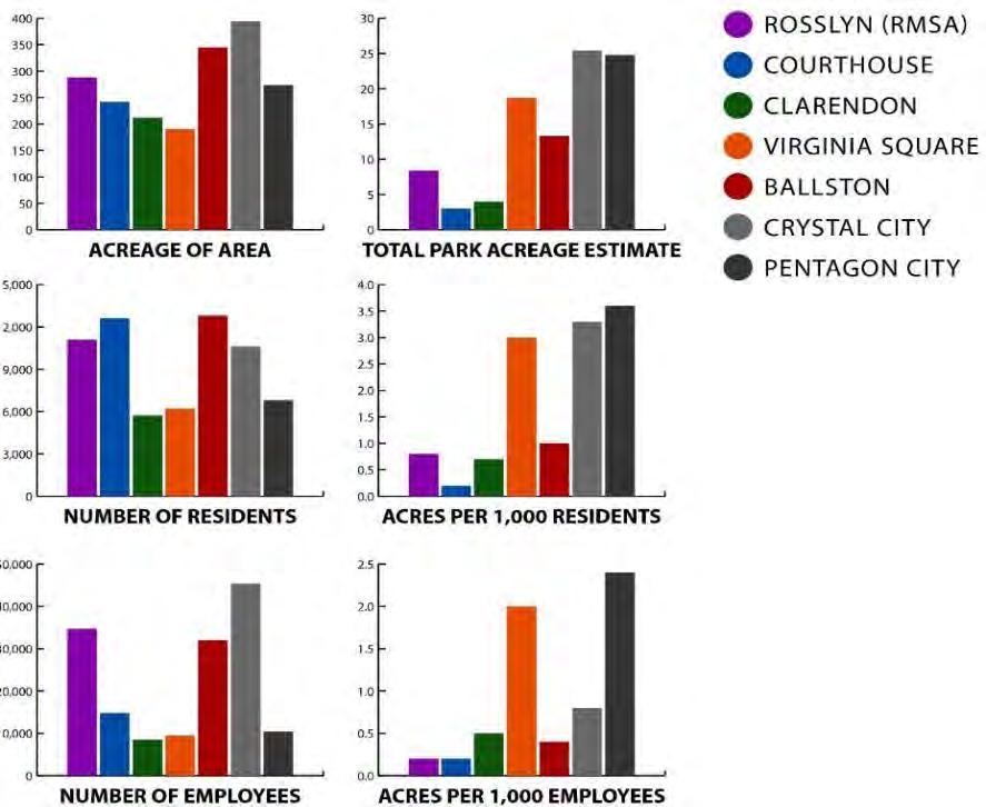
10 Rosslyn has become one of the most underserved areas in the County for active recreation and park space, as its population of employees, residents, and visitors has grown. Yet its existing parks and open spaces are underutilized due to challenges of facilities and access. 10


11 11


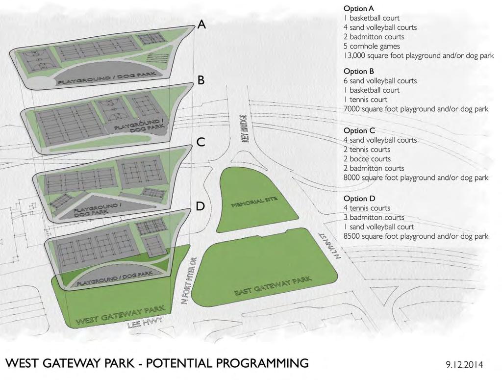
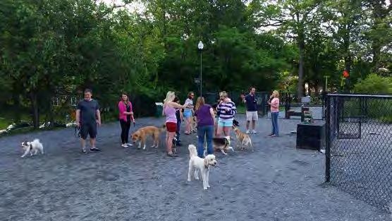
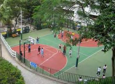
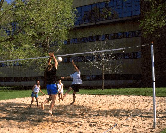
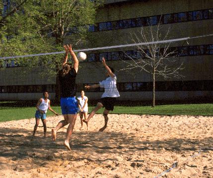
12 Rosslyn s current open space network is dominated by passive spaces and is severely lacking in active recreation amenities. Sample of identified program needs: Playground Dog park Court & field sports River sports 12


13 Many of the nearest public active recreation amenities are not walkable to much of the Rosslyn Coordinated Redevelopment District. Map produced by Arlington County Dept. of Environmental Services, GIS Division and Dept. of Parks and Recreation, Park Development Division 13


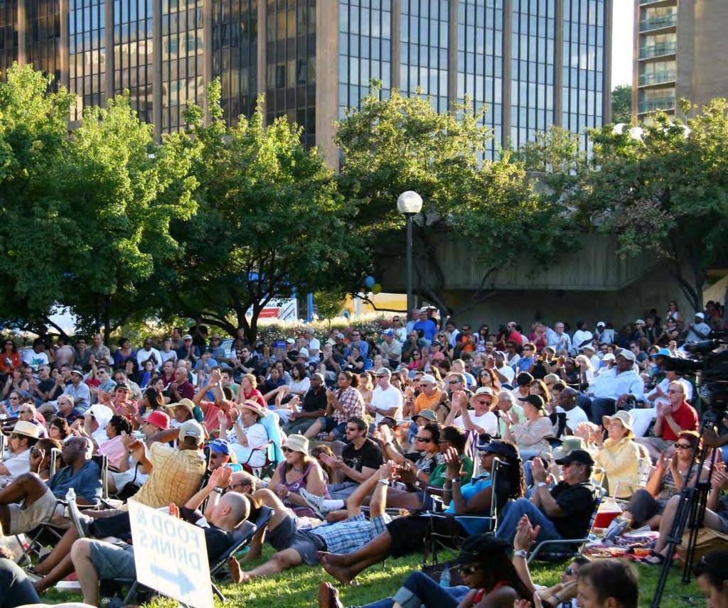
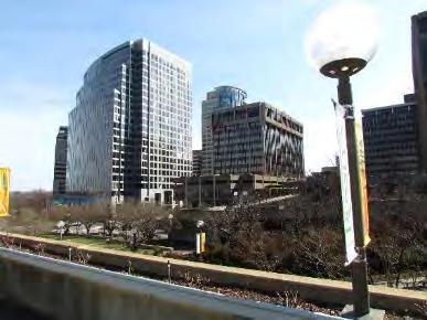
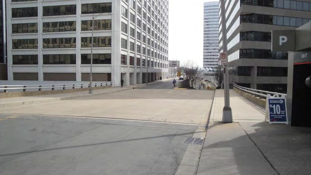
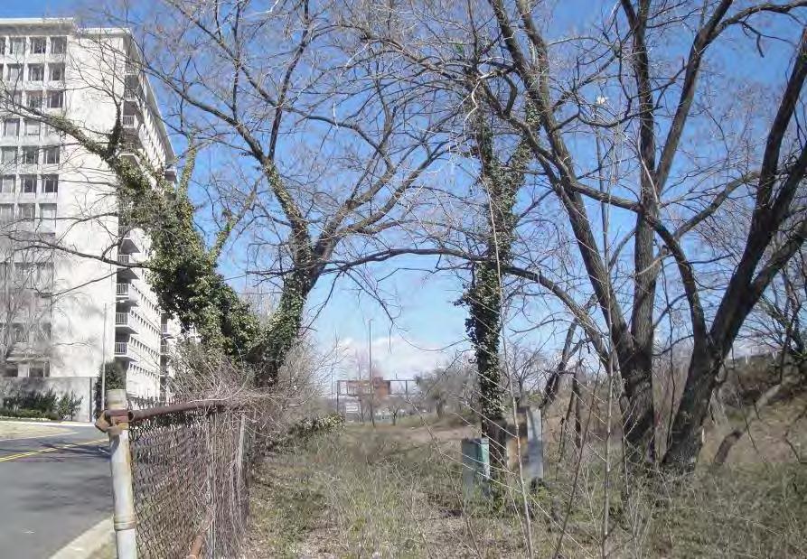
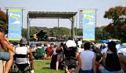
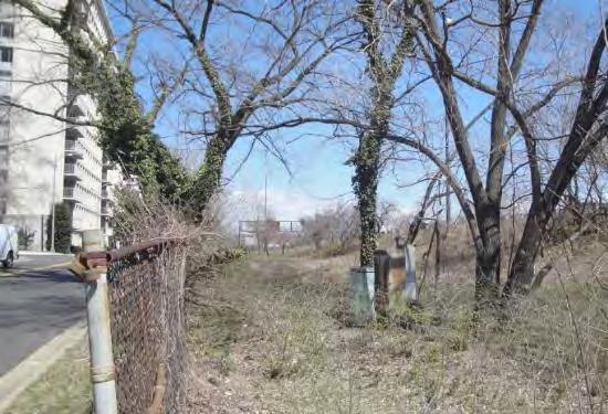
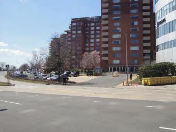
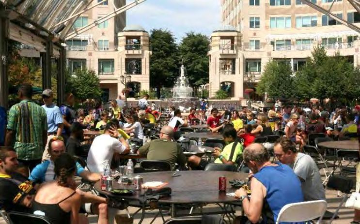
14 Publicly accessible private plazas occupy a significant amount of area but offer little quality public space. Many of Rosslyn s open spaces lack adequate accessibility and visibility. Steep grade changes and above- or below-grade plazas. Auto infrastructure and traffic barriers. Hardscape features and blank walls; lack of green and vegetation 14

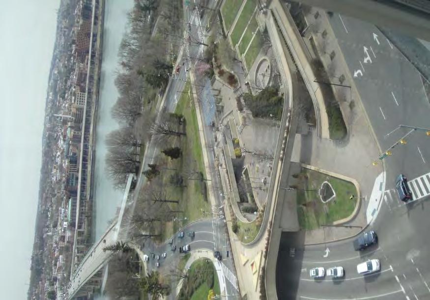
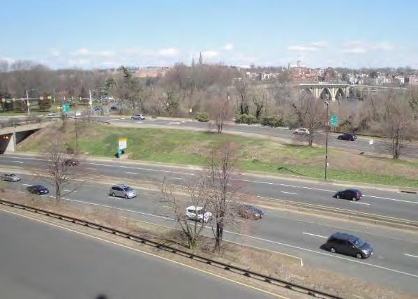
15 Access is constrained to regional park and path resources along George Washington Memorial Parkway and to bridges across the Potomac River. Image credit: Flickr user Clio


16 16


17 17


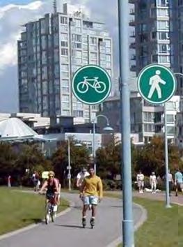
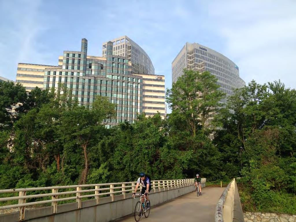
18 18


19 19


20 20


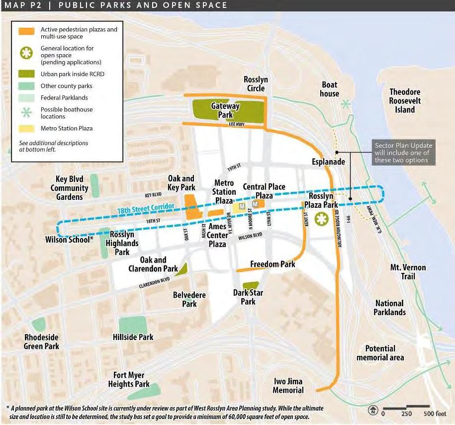
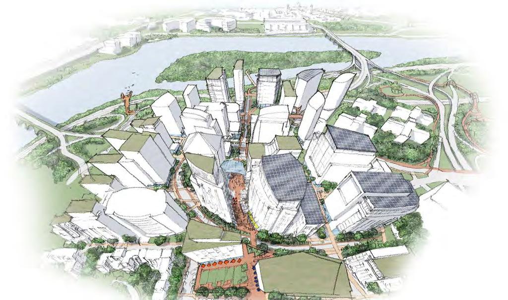
21 Image source: Rosslyn BID 21
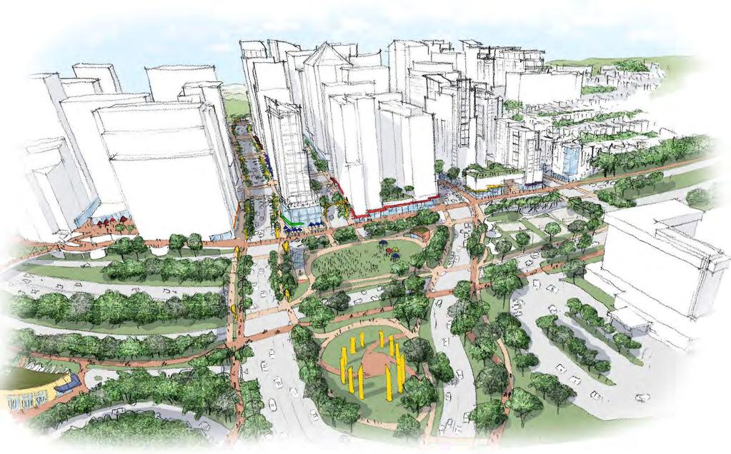
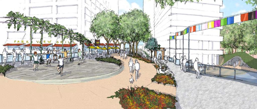
22 Destination Spaces Unique features, attracting visitors from the community, region and beyond (e.g. vista, monument, programmed events) Typically larger in size, can be multi-use in function Recreation Spaces Used for active recreation and leisure activities. Amenities can include playgrounds, sport facilities, dog parks, trails Depending on scale, can serve the neighborhood, the community, even the region Revitalizing Spaces Opportunity for respite, socializing, transition, reflection Form/amenity may vary: hardscape or soft-scape; small urban plazas, nature preserves, intimate spaces in larger parks. Seating, picnic tables, gardens, walking trails, public art Linking Spaces Connect other open spaces in an integrated, accessible network Often linear in form (e.g. trails, greenways, streets, linear plazas) Amenities include greenery and vegetation, seating, lighting, ecological corridors 22
23 23
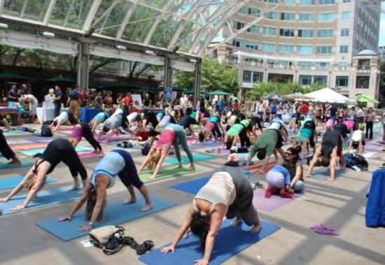
24 ` 24


25 Regional multi-use trail network improved, leveraged Filling regional gaps Improving local access Serving recreation and everyday transportation New cycle tracks protected from traffic Bike boxes for safer left turns at major intersections Walking path 25


26 Hope Street, Los Angeles Bethesda Row Chicago, IL 26


27 Cycle tracks Pathway bridges over roadways Olympic Sculpture Park, Seattle Millennium Park, Chicago 27

28 Existing parks with new access, facilities, and other improvements Gateway Park Freedom Park Dark Star Park New park spaces adding exciting new experiences to Rosslyn The Esplanade Rosslyn Plaza Park 18 th Street Corridor 28


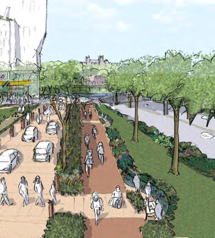
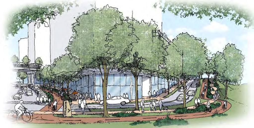
29 Type: Destination/Recreation Space ( game changer ) Description and major improvements: Destination and gateway for neighborhood recreation, large events; remove ramp structures. Area 3.4 ac. Program: Large event space/lawn seating for live music, films Neighborhood recreational courts Canine friendly area Kiosks, café, food trucks Children s play Information and wayfinding point for connected memorial site, regional pathways, boathouse Circuit training Meditative arts - yoga and tai chi Seasonal gardens Water features Bike and jogging station 29
30 30
 Social recreation (bocce, yoga, dance, tai chi, etc.")
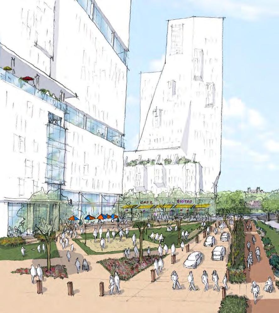
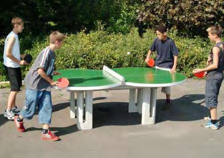
31 Type: Revitalizing Space Description and major improvements: Expansion of existing green space opportunities, views and activities on the elevated surface. Area 1.5 ac. Program: Walking/strolling with views to Rosslyn (possible green circle walking loop tied into Kent, 19 th, Nash and 17 th Streets) Social recreation (bocce, yoga, dance, tai chi, etc.) High quality landscape features Outdoor dining Sitting and relaxing Green design (stormwater management, large planters, trees) Coordinated lighting and paving Civic art/parklets/themed programming including music and other performing arts (Artisphere) 31

32 32


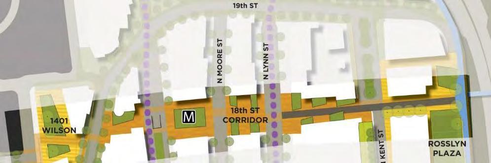
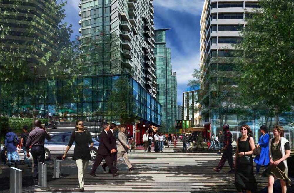
33 33


34 Type: Revitalizing Space Description and major improvements Enhanced "arts park" gateway located near Marine Corps Memorial; restored landscape, more art. Area 0.7 ac. Program: Public art and sculpture Inviting topography and landforms Strolling paths and seating Water features Bold seasonal gardens at the urban scale 34

 Add streetscape enhancements to invite")
35 Rehabilitate landscape; respect artist intent with enhancements Expand park area as roadways shrink Integrate into welcoming walk/bike route to Iwo Jima and Netherlands Carillon (Meade St. Bridge project) Add streetscape enhancements to invite neighborhood use 35


36 Type: Linking Space ( game changer ) Description: An esplanade is a linear space for walking, commonly along water. Rosslyn s will create a green "front" with strolling and recreational activity, tied into the regional Potomac corridor park system, extending from Gateway Park and adjacent memorial site to the National Marine Corps Memorial (Iwo Jima). Area 2.4 ac Program: Walking/strolling Sitting and resting areas Access and views to the Potomac River landscape Pedestrian bridge connecting to waterfront park Cycling Public art and sculpture Seasonal gardens 36
37 37


38 38
39 Type: Destination/Recreation Space ( game changer ) Description: Large park and plaza linked to surrounding development and available for flexible programs. Area ac Program: Festivals and live music (e.g., Annual Channel Gardens in Rockefeller Center, crafts fair) Larger recreation courts (volleyball and basketball, multi-purpose courts) Small recreation courts (bocce, horseshoes, etc.) Children s play features Outdoor dining and retail Open, flexible lawn area Community canine area Outdoor table games (chess, ping pong, etc.) 39


40 40


 Interactive fountain")
41 Type: Linking Space overlapping other Linking/Revitalizing Spaces Description: Variety of potential programming within street and contiguous parks; hardscape/softscape; links entire district west to east. Area approx ac Program, various locations: Public space with steps between Oak and Key Park and Metro Station Plaza Active pedestrian use in paved areas Spill over outdoor dining from adjacent ground floor uses Possible retail and shops fronting onto plaza Iconic Metro station access Informal seating, landscape, and gathering space, in mix of shade and sun, paved and planted areas Buskers and public art Live performances (stage and deck) Interactive fountain Farmer s market 41


42 42
43 43
44 Park Type Theme Gateway Park Destination/ Recreation Space Rosslyn s Front Door and Regional Event Hub Freedom Park Revitalizing Space The Elevated Green Promenade Dark Star Park Revitalizing Space The Arts Gateway The Esplanade Linking Space Rosslyn s Potomac Promenade Rosslyn Plaza Park 18 th Street Corridor Destination/ Recreation Space Linking Space overlapping other Linking/Revitalizing Spaces Rosslyn s Terrace on the Potomac Rosslyn s New Urban Spine 44


45 45

 More neighborhood-serving activities Integrate park program and design with: Key Bridge memorial site Mt.")
46 Main strategies: Remove ramp/bridge structures to improve visibility, expand space available for programming Update programming/facilities: Festivals/events Range of informal everyday activities (seating, recreation, games etc.) More neighborhood-serving activities Integrate park program and design with: Key Bridge memorial site Mt. Vernon and Custis Trails Boathouse Esplanade Gateway Park Conceptual Alternatives study 46


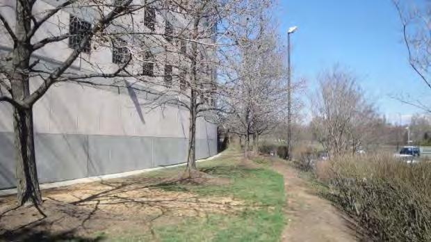
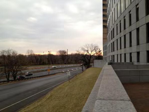
47 Continue general approach of Alternatives Study Scheme 2 Large flexible-use lawn space with support facilities to east Mix of smaller multi-purpose and dedicated program areas to west Gateway Park Conceptual Alternatives study 47
48 48
49 49

50 Esplanade connection Great Lawn Retail/dining overlooking park Safe, inviting bike & pedestrian access Varied neighborhood park activities Trail, boathouse & Key Bridge connections Coordinated memorial landscape Event support facilities restrooms, food, power, water 50
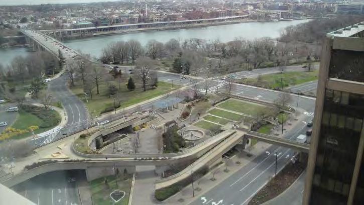
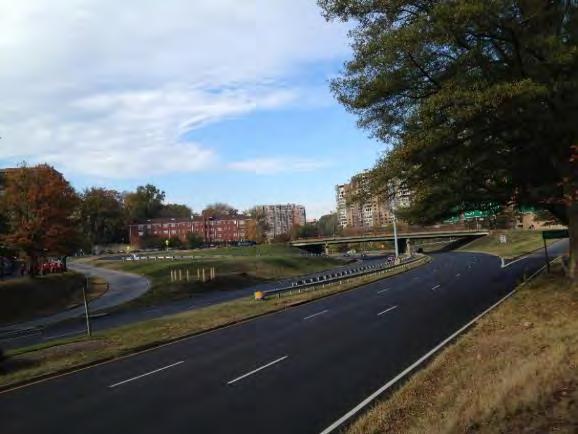
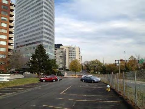
51 Main strategies: Linear promenade and multiuse path Destination experience Segment of regional and neighborhood networks Connecting element Separated from streets, but sometimes runs along them Two crossings over I-66 are possible options, where one would be selected and built Rosslyn Plaza Park Episodic overlaps with larger parks Gateway Park Rosslyn Plaza Iwo Jima Freedom Park via Rosslyn Plaza Also future boathouse Also GW Memorial Pkwy and the Potomac landscape 51
52 Engagement of developed urban edge social activity, dining, retail Engagement with periodically programmed parks Views To Roosevelt Island Up and down the Potomac landscape Close-range open space Regional park network Recreation active and passive Landscape plantings, seasonality Variety of closure and openness Two crossings over I-66 are possible options, where one would be selected and built Rosslyn Plaza Park 52
53 Two crossings over I-66 are possible options, where one would be selected and built A: Gateway Park B: Waterview/Potomac Tower C: Rosslyn Plaza D: River Place/Iwo Jima Rosslyn Plaza Park 53

54 Opportunities Major linkage & gateway point with Custis and Mt. Vernon Trails, Key Bridge, Gateway Park, future memorial site, boathouse, Rosslyn streets Constraints Integrating with major streets Multiple intersections Significant traffic volumes Improving access from Rosslyn core 54
55 55


56 Proposed section Wide sidewalks flanking Lee Hwy bring experience of Gateway Park to both sides of street Street tree selection and planting beds coordinated with Gateway Park design ESPLANADE 56


57 Precedents Katy Trail, Dallas Park-like sidewalk along a busy street Los Angeles, CA Katy Trail, Dallas 57
58 Opportunities Views of Roosevelt Island and Potomac landscape Additional access to Waterview public plaza and potential future air rights Alternate or interim route via Lynn and 19 th Streets Constraints Narrow existing condition Accommodating grade changes and access to plazas at different levels Highway visibility and noise 58


59 59


60 Proposed section 20 multi-use path along Waterview Place and Potomac Tower Navigate approx. 12 grade change from N Lynn to 19 th St/ Arlington Ridge Rd Consider providing vertical access to public plaza Potential access ESPLANADE 60


61 Precedents Multiuse path above existing highway Brooklyn Heights Promenade Sense of enclosure provides alternative to wide vistas High Line 61
62 Opportunities Views to Roosevelt Island, Potomac, and future Rosslyn Plaza Engages with redeveloped urban edge, Potomac trails Connect to Rosslyn core via 19 th, 18 th, 17 th, Wilson Continue south toward Iwo Jima via new Wilson Blvd crosswalk/intersection Constraints Coordination with phased private redevelopment Highway visibility and noise Phasing with pedestrian bridge over I-66 and G.W. Memorial Parkway 62


63 63

64 Proposed section 12 multi-use trail east of Arlington Ridge Rd Bicycles share use of Arlington Ridge Rd Looking north +70 AMSL 64

65 Proposed section 12 multi-use trail east of Arlington Ridge Rd Bicycles share use of Arlington Ridge Rd I-66 ESPLANADE 65

66 Concept Sketch 66

67 67


68 Precedents Pedestrian promenade with artistic fountains Scioto Mile, Columbus, OH Seating, trellis structures, and greenery along multiuse path Katy Trail, Dallas Shared street design allows all users to navigate the space Brighton, England New York, NY 68


69 Precedents Pedestrian bridge over highway Rosemont Bridge, Houston Multi-use promenade with seating Hoboken, NJ New York, NY 69
70 Opportunities Access to/from existing high density residential development Links Gateway Park all the way to Iwo Jima Connects to regional trail network Constraints Likely long-term development Crossing Wilson Blvd and Arlington Blvd/Rt 50 70


71 71

72 Proposed section 20 multi-use trail west of Wilson Blvd Wilson Blvd ramp ESPLANADE 72


73 Sample sequence ` ` ` ` ` ` ` ` ` ` ` ` ` ` ` ` ` 7 73


74 Type: Destination Park ( game changer ) Description: Large park and plaza linked to surrounding development and available for flexible programs. Area ac Program: Festivals and live music (e.g., Annual Channel Gardens in Rockefeller Center, crafts fair) Larger recreation courts (volleyball and basketball, multi-purpose courts) Small recreation courts (bocce, horseshoes, etc.) Children s play features Outdoor dining and retail Open, flexible lawn area Community canine area Outdoor table games (chess, ping pong, etc.) 74
75 75


76 Main strategies: Design and program as active destination Create significant visual and access connections to The Esplanade, Wilson, 17 th, 18 th, 19 th Streets Thoroughly integrate design and use with adjacent development Layout alternatives: Locate major space to connect the Esplanade with Kent Street Locate major space along the Esplanade Scenario 1 Scenario 2 esplanade esplanade 76
77 0.7 ac (green + brown area) 100 wide corridor Esplanade 77


78 Esplanade 0.7 ac (green + brown area) ~100 between buildings View from northwest to river 78
")

79 1 ac (green + brown area) 50 wide corridor Esplanade 79
80 Esplanade 1 ac (green + brown area) 50 wide corridor 80
81 SCENARIO 1 Series of spatial experiences Retail-themed square at Kent/18 th, buffered from highway presence (0.4 ac, approx. 1,600 people) Park at Esplanade (0.2 ac, approx. 800 people) Passage between (0.1 ac) Highlights view toward Arlington Mem. Bridge SCENARIO 2 Emphasis on one grand space More event variety/ capacity (1 ac, approx. 4,000 people) Greater sense of presence in Potomac landscape Broader range of views Smaller retail plaza/passage at Kent/18th 81


82 SCENARIO acres programmable space 1 ac overall open space on block SCENARIO 2 1 acre programmable space 1.1 ac overall open space on block 82


83 83
GOODY CLANCY WITH KITTELSON & ASSOCIATES RHODESIDE & HARWELL FARR ASSOCIATES W-ZHA
 1 1. Welcome 5 min. 2. Follow-up from 9/22 / Corridor of Light, ground floor uses 20 min. 3. Small on-site open spaces / Overview of types, identities 15 min. 4. Rosslyn Plaza Park / Rosslyn Plaza PDSP
Adoption of the Rosslyn Sector Plan Site Plan Review Committee (SPRC) Meeting October 26, 2015
 Meeting October 26, 2015") Adoption of the Rosslyn Sector Plan Site Plan Review Committee (SPRC) Meeting October 26, 2015 Rosslyn Sector Plan Introduction Adopted by the County Board in July 2015 Reflects the new long range planning
Adoption of the Rosslyn Sector Plan Site Plan Review Committee (SPRC) Meeting October 26, 2015 Rosslyn Sector Plan Introduction Adopted by the County Board in July 2015 Reflects the new long range planning
W i l s o n B o u l e v a r d & K e y B o u l e v a r d
 1 4 0 1 W i l s o n B o u l e v a r d & 1 4 0 0 K e y B o u l e v a r d R o s s l y n, A r l i n g t o n C o u n t y, V i r g i n i a S i t e P l a n R e v i e w C o m m i t t e e M e e t i n g # 8 0 4.
Realizing Rosslyn: a new era of opportunity GOODY CLANCY WITH KITTELSON & ASSOCIATES RHODESIDE & HARWELL FARR ASSOCIATES W-ZHA
 Realizing Rosslyn: a new era of opportunity 1 AGENDA 1. Welcome 5 min. 2. Overview 5 min. 3. Emerging Recommendations A. Building Height and Massing 40 min. B. 18 th Street Corridor Details 15 min. C.
Throughout. square. (Crystal City Vision Plan 2050)
") 1: Terms related to the PSMP document 1 public space (see also public realm, civic space) An open space designated on the regulating plan, accessible to all, including Plazas, Mini Parks, and Neighborhoods
1: Terms related to the PSMP document 1 public space (see also public realm, civic space) An open space designated on the regulating plan, accessible to all, including Plazas, Mini Parks, and Neighborhoods
Project Introduction Visioning. Next Steps. Slide 1
 Project Introduction Visioning QA Next Steps Slide 1 Good Gateway to Arlington Great Neighborhood Park for Rosslyn Slide 2 Existing Conditions Program Conceptual Strategies Slide 3 Existing Conditions
Courthouse Square Planning & Urban Design Study. Courthouse Square Working Group #13 October 15, 2014
 Courthouse Square Planning & Urban Design Study Courthouse Square Working Group #13 October 15, 2014 1 Courthouse Square Process Working Group Community Courthouse Square Advisory Groups & Civic Associations
Neighborhood Districts
 NEIGHBORHOOD DISTRICTS SEVEN MAIN DISTRICTS Neighborhood Districts While the Development Plan provides a broad-scale overview of the neighborhood, this section focuses on uses and relationships at the
public review draft Key objectives for this chapter are:
 5 - parks & open space Providing a rich collection of outdoor places for informal gathering and recreation, as well as planned promotional activities and community events, is a key concept for Midtown.
Gold Line Bus Rapid Transit Transit Oriented Development (BRTOD) Helmo Station Area Plan
 Helmo Station Area Plan") Appendix F Gold Line Bus Rapid Transit Transit Oriented Development (BRTOD) Helmo Station Area Plan Introduction and Purpose of the Plan The Gold Line Bus Rapid Transit facility is an eleven-mile dedicated
Appendix F Gold Line Bus Rapid Transit Transit Oriented Development (BRTOD) Helmo Station Area Plan Introduction and Purpose of the Plan The Gold Line Bus Rapid Transit facility is an eleven-mile dedicated
Appendix I ARLINGTON COUNTY SECTOR PLANS SUMMARY RECOMMENDATIONS RELATED TO PUBLIC SPACES
 Appendix I ARLINGTON COUNTY SECTOR PLANS SUMMARY RECOMMENDATIONS RELATED TO PUBLIC SPACES The County has developed Sector Plans for various planning areas within Arlington County s Metro corridors. Following
PORT OF VANCOUVER WATERFRONT DEVELOPMENT. Concept Development Plan City Center Redevelopment Authority April 20, 2017
 PORT OF VANCOUVER WATERFRONT DEVELOPMENT Concept Development Plan City Center Redevelopment Authority April 20, 2017 Port History PORT ESTABLISHED 1912 TERMINAL 1 ACQUIRED 1925 GWM SIGNS LEASE 1935 HARBOR
DRAFT ROOSEVELT ROAD. District Recommendations. Figure 5.23 The Roosevelt Road Corridor
 CHAPTER 5 Figure 5.23 The Road Corridor Road will develop as a mixed-use corridor, emphasizing regional retail, west of the river and mixed-use development east of the river. KEY RECOMMENDATIONS 1. High
Rosslyn Plaza PDSP (SP #422) SPRC Staff Presentation
 SPRC Staff Presentation") Rosslyn Plaza PDSP (SP #422) SPRC Staff Presentation ote Guiding Principles included in this document are taken from the latest working draft of the Guiding Principles dated. The illustrations included
Rosslyn Plaza PDSP (SP #422) SPRC Staff Presentation ote Guiding Principles included in this document are taken from the latest working draft of the Guiding Principles dated. The illustrations included
Open Space Considerations
 Open Space Considerations Department of Parks & Recreation WESTERN ROSSLYN AREA PLANNING STUDY WORKING GROUP MEETING OCTOBER 9, 2014 1 Purpose of the Presentation Provide context of the Rosslyn park and
Planning Board Briefing
 Planning Board Briefing Why Now? The Sector Plan Implementation Chapter States: Before Stage 1 begins, the following must occur: Approval of the Sectional Map Amendment. Approval of the Greater Lyttonsville
Rosslyn Sector Plan Implementation
 DEPARTMENT OF COMMUNITY PLANNING, HOUSING AND DEVELOPMENT Planning Division #1 Courthouse Plaza, 2100 Clarendon Boulevard, Suite 700 Arlington, VA 22201 TEL 703.228.3525 FAX 703.228.3543 www.arlingtonva.us
3.1 community vision. 3.3 required plan elements
 Chapter 3 Community Form 3.1 community vision 3.2 Parks & landscaping concepts 3.3 required plan elements D R A F T 20 Community Form Chapter 3 3.0 Community form 3.1 community vision The Specific Plan
PUBLIC REALM DESIGN PLAN APRIL, 2012
 PUBLIC REALM DESIGN PLAN APRIL, 2012 Introduction NoMa is growing quickly. Fueled by transit accessibility, proximity to both Downtown and Capitol Hill and streamlined entitlements, the neighborhood has
DOWNTOWN RESIDENTIAL DISTRICT DEVELOPMENT OPPORTUNITES
 DOWNTOWN RESIDENTIAL DISTRICT DEVELOPMENT OPPORTUNITES Out of all the areas in Downtown Painesville, this district provides the greatest opportunity for change with the vacation of Lake East Hospital.
W&OD PARK MASTER PLAN. The City s Greenest Street. DRAFT W&OD Trail Master Plan v4.docx Page 1
 W&OD PARK MASTER PLAN Adopted XXX-XX-XXXX The City s Greenest Street DRAFT W&OD Trail Master Plan v4.docx Page 1 Introduction and Purpose The Washington & Old Dominion Railroad Regional Park (W&OD) (which
Dowdy Park. Concept Plans TOWN OF NAGS HEAD NORTH CAROLINA. Developed by: Albemarle & Associates, Ltd VHB/ Vanasse Hangen Brustlin, Inc.
 TOWN OF NAGS HEAD NORTH CAROLINA Concept Plans Developed by: Albemarle & Associates, Ltd VHB/ Vanasse Hangen Brustlin, Inc. Site Looking Southeast Dowdy Park Existing Conditions Nags Head Woods Sound Future
THE NEIGHBORHOOD TODAY
 THE NEIGHBORHOOD TODAY CORE AREA VISION How are we Good Urbanism A Site s DNA thinking about Elements of great Unique elements urban communities embedded in a place the site and design? ELEMENTS LIKE:
Courthouse Square Planning & Urban Design Study
 Courthouse Square Planning & Urban Design Study Transit Advisory Committee October 14, 2014 Andrew D huyvetter, AICP, Associate Planner Center for Urban Design and Research Department of Community Planning,
PUBLIC RIGHT-OF-WAY IN THIS CHAPTER PUBLIC REALM
 PUBLIC RIGHT-OF-WAY This section provides design guidelines for improvements in the public right-of-way. The public right-of-way refers to streets, sidewalks, non-vehicular thoroughfares, parks and greenways
Transportation. Strategies for Action
 Transportation A major priority for the Overlake Neighborhood is to develop a multimodal transportation system. To achieve this system, a balance has to be found among travel, circulation and access needs;
Charles P. Johnson and Associates. Annapolis Landscape Architects
 Charles P. Johnson and Associates Annapolis Landscape Architects AGENDA Introduction Project Limits and Scope Site Analysis Opportunities & Constraints Program Goals Image Boards Design Alternatives Pros
ROSSLYN PLAN FRAMEWORK
 ROSSLYN PLAN FRAMEWORK VISION PRINCIPLES AND POLICY DIRECTIVES TO GUIDE THE ROSSLYN SECTOR PLAN UPDATE DRAFT 2014.02.19 MARCH 2014 IMAGE COURTESY OF JBG COMPANIES. DRAFT 2014.02.19 ROSSLYN PLAN FRAMEWORK
ROSSLYN GATEWAY URBAN DESIGN MANUAL JULY 15, 2011 REVISED JANUARY 30, KOHN PEDERSEN FOX ASSOCIATES PC. All rights reserved.
 ROSSLYN GATEWAY URBAN DESIGN MANUAL JULY 15, 2011 REVISED JANUARY 30, 2012 OVERVIEW Rosslyn Gateway is mixed-use development located at the Virginia landing of the Francis Scott Key Bridge in Rosslyn,
Urban Design 9Identity
 Urban Design 9Identity URBAN DESIGN IDENTITY Urban design is about connecting people to their places through the built environment, nature, and overall urban form. Done well, it creates a memorable space
PROPOSED REDEVELOPMENT OF THE GLEN ABBEY GOLF CLUB. STREETSCAPE DESIGN STUDY (excerpt from the Urban Design Brief) TOWN OF OAKVILLE.
 TOWN OF OAKVILLE.") PROPOSED REDEVELOPMENT OF THE GLEN ABBEY GOLF CLUB STREETSCAPE DESIGN STUDY (excerpt from the Urban Design Brief) TOWN OF OAKVILLE OCTOBER, 2016 for 2.4.2 STREETS Streets are the single largest component
PROPOSED REDEVELOPMENT OF THE GLEN ABBEY GOLF CLUB STREETSCAPE DESIGN STUDY (excerpt from the Urban Design Brief) TOWN OF OAKVILLE OCTOBER, 2016 for 2.4.2 STREETS Streets are the single largest component
WELCOME and introduction
 1 WELCOME and introduction Mobility Hub Locations within Burlington STUDY OVERVIEW STUDY OBJECTIVES The City of Burlington is developing four Area Specific Plans, one for each of Burlington s Mobility
Washington Park Diagonal
 Public Input Meeting August 3, 2011 Nicole Stahly RLA DPR Project Manager Jesse Clark RLA, LEED Stream Design Paul Thomas RLA Stream Design Kerry White RLA Urban Play Studio Tonight s Agenda 1st Meeting:
Bloor Street East Potential Ravine Portal Overlook and Access Passage to the Rosedale Valley and Don River Valley Ravine, Toronto, Canada
 TRANSFORMATIVE IDEA 2. GREAT STREETS Bloor Street Christie Pits Park Bloor St Spadina Ave Bathurst St Shaw St 1 Recognize the significant public realm improvements along Bloor Street and extend and enhance
Ivywild On The Creek PRELIMINARY CREEK DISTRICT MASTER PLAN
 Ivywild On The Creek PRELIMINARY CREEK DISTRICT MASTER PLAN Introduction: Rejuvenating an extraordinary Creekside neighborhood THE CREEKSIDE DISTRICT The Ivywild On The Creek Neighborhood District Master
BUSINESS DISTRICT DESIGN GUIDELINES
 Des Plaines, Illinois Prepared for the City of Des Plaines by: The Lakota Group Laurie Marston, AICP March 2005 Section 5: Streetscape Elements Business District Design Guidelines STREETSCAPE ELEMENTS
Courthouse Square Planning & Urban Design Study. Clarendon / Courthouse Civic Association October 21, 2014
 Courthouse Square Planning & Urban Design Study Clarendon / Courthouse Civic Association October 21, 2014 1 Courthouse Square Process Working Group Community Courthouse Square Advisory Groups & Civic Associations
Welcome. Community Consultation Meeting November 28, Review and discuss the Bathurst Quay Neighbourhood Plan Framework
 Welcome Community Consultation Meeting November 28, 2016 Why Are We Here Today? Review and discuss the Bathurst Quay Neighbourhood Plan Framework Review and discuss an Action Plan for Implementation Next
Riverwalk Dreams compiled by Thomas P. Healy November 16, 2017
 Riverwalk Dreams compiled by Thomas P. Healy November 16, 2017 1986 Ripple Village Plan: A neighborhood plan developed by the City of Indianapolis Department of Metropolitan Development s Division of Planning
City of Plattsburgh DRI: Downtown Streetscapes & Riverfront Access. Downtown Streetscape and Riverfront Access Design
 City of Plattsburgh DRI: Downtown Streetscapes & Riverfront Access Welcome Thank you for coming this evening. Agenda PART I - Project Context The Downtown Revitalization Program Our DRI Projects Other
Emerson Park Master Plan Update. Public Meeting III August 27, 2014
 Emerson Park Master Plan Update Public Meeting III August 27, 2014 Meeting Agenda: Project Update Presentation of Master Plan Components Discussion and Feedback The Path Forward: Building on the Concept
City of Farmington. Downtown Plan. Amendment to the 1998 Master Plan Adopted October 11, 2004
 City of Farmington Amendment to the 1998 Master Plan Adopted October 11, 2004 Introduction Planning Background 1 Scope and Components of the Plan Amendment 2 Concept Introduction 3 Plan Concepts 3 Conceptual
V. Gateways GATEWAYS / V-1
 V. GATEWAYS / V-1 Many of Chesapeake s gateways are located on highways and call for bold and attractive designs that motorists can understand, appreciate, and enjoy. can also take the form of natural
Envision Courthouse Square - Civic Engagement Comment Summary (Updated 6/11/14)
") Activation of through very important FREQUENCY : OUTREACH EVENT 1,,,, : OUTREACH EVENT 2 Cultural center on Verizon Plaza, WG1: WORKING GROUP MEETING 1 Buildings to have WG1,,, Architectural/Artistic quality
Activation of through very important FREQUENCY : OUTREACH EVENT 1,,,, : OUTREACH EVENT 2 Cultural center on Verizon Plaza, WG1: WORKING GROUP MEETING 1 Buildings to have WG1,,, Architectural/Artistic quality
VEHICULAR AND PEDESTRIAN CIRCULATION
 This perspective sketch communicates the intended character and quality of a proposed streetscape design. Locate benches near a major intersection where people tend to gather. Seating and lighting provide
Lehigh Acres Land Development Regulations Community Planning Project
 Lehigh Acres Land Development Regulations Planning Effort Summary In July, 2010 Commissioner Frank Mann invited the Lehigh Acres community to start discussing how to achieve their recently adopted community
CRYSTAL CITY BLOCK PLAN # CCBP- G 1
 CRYSTAL CITY BLOCK PLAN # CCBP- G 1 BLOCK G (Metro Market Square block) Long Range Planning Committee Meeting #3 April 2, 2018 1 1. Tonight s Agenda 1. Introductory Remarks (Jane Siegel) 2. Follow-up from
Table of Contents. Elm Avenue Improvement Plan City of Waco, Texas. Introduction 1. Existing Context 1 Figure 1 2.
 Table of Contents Introduction 1 Existing Context 1 Figure 1 2 Plan Guidelines 3 Future Urban Form 4 The West-End 4 Main Street 6 The East-End 7 Figure 2 9 Public Improvement Recommendations 7 General
SOUTHEAST SPORTS COMPLEX MASTER PLAN
 REPORT TO SOUTHGATE NEIGHBORHOOD COUNCIL APRIL 13, 2016 Visioning Process April 30: Stakeholder Meeting with Sports Groups May 5: Stakeholder Meeting with Southgate Land Use Committee May 13: SNC Meeting
Planning Stage. Mosaic Park. Long Term Project. Restoration of 4 Mile Run. Planning Stage. Herndon and 13 th. Project Underway. Clarendon Central Park
 Planning Stage Long Term Project Planning Stage Project Underway Mosaic Park Restoration of 4 Mile Run Herndon and 13 th Clarendon Central Park Arlington County Parks, Recreation and Cultural Resources
Description of Preferred Alternative
 Chapter 2 Description of Preferred Alternative 2.1 Introduction This chapter of the programmatic Sammamish Town Center Sub-area Plan Final EIS provides a more detailed description of the Preferred Alternative
Complete Neighbourhood Guidelines Review Tool
 Complete Neighbourhood Guidelines Review Tool Prepared By: City of Regina Planning Department October 2014 Page 1 of 14 Community Development Review Checklist for Secondary Plans and Concept Plans The
POPS Advisory Committee Meeting May 31, 2018
 POPS Advisory Committee Meeting May 31, 2018 NOTE: This presentation is a working document, and some recommendations or ideas may have evolved or changed based on continued discussions and additional analyses.
The University District envisions, in its neighborhood
 Envisioning the University District Link Light Rail in Seattle s neighborhoods CIY OF SEALE CONCEP-LEVEL SAION AREA PLANNING RECOMMENDAION RESOLUION # 30165 EXHIBI L Vision 08.2000 he University District
Community Engagement Committee Meeting #1 December 10, :30pm-8:30pm
 Community Engagement Committee Meeting #1 December 10, 2014 6:30pm-8:30pm Welcome and Introductions Dana Murdoch Minneapolis Park and Recreation Board Project Manager Ryan French Walker Art Center Director
Sustainability, Health, Safety, Recreation & Open Space Working Group August 3, 2017
 Sustainability, Health, Safety, Recreation & Open Space Working Group August 3, 2017 DOWNTOWN OAKLAND SPECIFIC PLAN WELCOME Sustainability, Health, Safety, Recreation & Open Space Working Group Social
SPRINGHILL LAKE TRANSIT VILLAGE
 Greenbelt Metro Area Sector Plan - Subarea Design Policies and Guidelines - Springhill Lake Transit Village 113 SPRINGHILL LAKE TRANSIT VILLAGE Residential Neighborhood and Village Center CONCEPT Springhill
DRAFT. October Wheaton. Design Guidelines
 October 2011 DRAFT Wheaton Design Guidelines 2 Draft - Design Guidelines - Wheaton Sector Plan Contents 04 Section 1: Introduction 06 Section 2: Context 08 Section 3: Design Guidelines 09 Goal 1: Create
PRELIMINARY DESIGN + DEVELOPMENT PLAN
 WELCOME! To The Public Open House May 30 th, 2017 HARBOUR WEST PARKS Vision Project Overview The City s vision for Port Credit Harbour West Parks is to develop a vibrant waterfront destination that integrates
Realizing Rosslyn: a new era of opportunity GOODY CLANCY WITH KITTELSON & ASSOCIATES RHODESIDE & HARWELL FARR ASSOCIATES W-ZHA
 Realizing Rosslyn: a new era of opportunity PRESENTATION OUTLINE 2 3 4 Building tops tour: what we observed 5 Building height/form and urban design: interrelated elements 6 WORK SEQUENCE 7 Building height/form
Long Branch-Wayne Local Park Renovation Project
 Montgomery Parks Long Branch-Wayne Local Park Renovation Project Community Meeting #2 September 20, 2016 Oak View Elementary School 7:00-9:00 PM Welcome / Team Introductions M-NCPPC (Montgomery Parks)
4 Semi-Private & Private Open Spaces
 4 Semi-Private & Private Open Spaces 4.1 Semi-private Open Space 4.1.1 Common Courtyards The common courtyards for each complex will be designed and programmed for the typical owners living there. They
Westwood Shopping Center Sketch Plan, Plan # February 23, 2017 Item # 9
 Westwood Shopping Center Sketch Plan, Plan # 320170010 February 23, 2017 Item # 9 Westwood II Site 64,111 s.f. Manor Care site: vacant two story building HOC-Westwood Towers, 15 story tower To be considered
Luminous Bodies and the Corridor of Light for Lynn Street Rosslyn
 Luminous Bodies and the Corridor of Light for Lynn Street Rosslyn Artist & landscape architect Cliff Garten, Venice, CA selected Harbor View, Long Beach, CA Avenue of Light, Fort Worth, TX The project
ROSSLYN PLAN FRAMEWORK
 ROSSLYN PLAN FRAMEWORK VISION PRINCIPLES AND POLICY DIRECTIVES TO GUIDE THE ROSSLYN SECTOR PLAN UPDATE DRAFT 2014.01.31 MARCH 2014 DRAFT 2014.01.31 ROSSLYN PLAN FRAMEWORK CONTENTS Overview... 1 Plan Foundations...
BROOKHILL NEIGHBORHOOD MODEL ZONING MAP AMENDMENT PREFACE TO APPLICATION
 BROOKHILL NEIGHBORHOOD MODEL ZONING MAP AMENDMENT PREFACE TO APPLICATION June 15, 2015 Revised: August 1, 2016 I. VISION Brookhill is a proposed community based upon the principles of Albemarle County
DATE: October 25, Park, Recreation and Open Space Advisory Committee (PROSAC) Jordan Harrison, Planner III, RPD Planning Division
 Jordan Harrison, Planner III, RPD Planning Division") DATE: October 25, 2016 TO: FROM: RE: Park, Recreation and Open Space Advisory Committee (PROSAC) Jordan Harrison, Planner III, RPD Planning Division Possible Action on Potential Acquisition at Potrero
DATE: October 25, 2016 TO: FROM: RE: Park, Recreation and Open Space Advisory Committee (PROSAC) Jordan Harrison, Planner III, RPD Planning Division Possible Action on Potential Acquisition at Potrero
PLAN ELEMENTS WORKSHOP. April 5, 2016
 PLAN ELEMENTS WORKSHOP April 5, 2016 needs more housing. But there is no one-size fits-all solution. Every neighborhood has its own character. In some places, density is not only appropriate it is badly
OPEN HOUSE. Future. Neighborhood. Thursday April 27, :30 8:30 PM Refreshments provided Discovery Center, 4444 Hadley Avenue North
 OPEN HOUSE Thursday April 27, 2017 6:30 8:30 PM Refreshments provided Discovery Center, 4444 Hadley Avenue North The City Council has ini ated a planning process to guide future development on 206 acres
Courthouse Square Planning & Urban Design Study
 Courthouse Square Planning & Urban Design Study Pedestrian Advisory Committee November 12, 2014 Kris Krider, AICP, Planning Supervisor Center for Urban Design and Research Department of Community Planning,
Additional information about land use types is given in Chapter 5. Design guidelines for Centers and Neighborhoods are given in Chapter 7.
 4. Place Types Introduction In Albemarle County s Development Areas, the Neighborhood is the fundamental unit of community planning. The County s Neighborhood Model, an adopted part of the Comprehensive
Blue Line LRT Extension
 v e Noble Pkwy Noble Pkwy Xerxes Ave N Shingle Creek Penn Ave N Penn Ave N Fremont Ave N Lyndale Ave N S Washington Ave University Ave NE Blue Line LRT Extension LIGHT RAIL PLATFORM AND STATION DESIGN
OPEN SPACE TYPES. SIZE 8 acres. SIZE 20 acres. SIZE 1 acre
 TYPICAL CHARACTERISTICS OPEN SPACE TYPES OPEN SPACE TYPES The neighborhood contains an extensive variety of open space types. Most of these spaces incorporate multiple uses and activities, so that each
Section4 Design Vision & Implementation Plan
 Section4 Design Vision & Implementation Plan W Woodschurch Rd 4.1 Design Focus Areas The Framework Plan is simply the starting point for directing the design and implementation of a wide range of transportation
Standards (R-3) Figure B-11: R-3 Residential Standards Exhibit
 Figure B-11: R-3 Residential Standards Exhibit") Avila Ranch Avila Ranch Specific Plan Development Standards High Medium Density - High Residential Density Residential Lot and Building Lot and Standards Building (R-3) Standards (R-3) EXAMPLES These sketches
Avila Ranch Avila Ranch Specific Plan Development Standards High Medium Density - High Residential Density Residential Lot and Building Lot and Standards Building (R-3) Standards (R-3) EXAMPLES These sketches
ARLINGTON COUNTY, VIRGINIA
 ARLINGTON COUNTY, VIRGINIA County Board Agenda Item Meeting October 15, 2005 DATE: September 28, 2005 SUBJECT: Request to Advertise the adoption of the 2005 Clarendon Sector Plan C. M. RECOMMENDATION:
Vision Plan Kickoff Meeting Summary Report
 Vision Plan Kickoff Meeting Summary Report October 2018 The Vision Plan With the redevelopment of the Amtrak Property, Penn Station Partners (PSP) seeks to build on the creative talent and entrepreneurial
CRYSTAL CITY BLOCK PLAN # CCBP- G 1 DRAFT
 CRYSTAL CITY BLOCK PLAN # CCBP- G 1 DRAFT BLOCK G (Metro Market Square block) Long Range Planning Committee Meeting January 29, 2018 1 1. Introduction 2 1. LRPC Meeting Purpose Review of proposed Crystal
Public Workshop. November 8, 2014 Key Elementary School
 Public Workshop November 8, 2014 Key Elementary School Agenda: I. Opening Remarks II. Overview of Study III. Review of Concept Plans IV. Q&A V. Break VI. Table Exercises VII. Wrap Up VIII. Adjournment
Nagle Place Extension Workshop August 3, 2010
 Nagle Place Extension Workshop August 3, 2010 Overview On Tuesday, August 3, 2010, Sound Transit, the Capitol Hill Community Council, the Capitol Hill Chamber of Commerce and the City of Seattle teamed
1.0 VISION STATEMENT. December 6, PRINCIPLES
 Vision Statement Lincoln Regional Airport 1.0 VISION STATEMENT 1.1 City LOCATION of AND OVERVIEW The Easton Lincoln Place Land Use Master Plan identifies the principles, goals, policies, and standards
A Vibrant Downtown. Chapter 5 Cary Public Art Opportunities 31
 A Vibrant Downtown Cary s vision for Downtown is a unique, vibrant, dynamic, pedestrian friendly location; a regional destination and a place to live, work, and recreate, according to the 2001 Town Center
CHAPTER 4: CONSERVATION
 CHAPTER 4: CONSERVATION Transform Rio29 into a place enhanced through conservation with a network of sustainable and usable public spaces that enrich community and preserve and enhance natural resources.
7-PARKS, OPEN SPACE & PUBLIC ART
 7-s, Open Space & Public Art 7-PARKS, OPEN SPACE & PUBLIC ART This chapter provides recommendations for the expansion of new parks, plazas and open space that serve the many user groups targeted for downtown.
Hockessin Community Redevelopment Plan
 Hockessin Community Redevelopment Plan 3.1 Introduction The Community Redevelopment Plan for the Village of Hockessin is the result of the people s vision for a distinct village center that serves as the
February 27, 2018 City Council Presentation The Crown Jewel Park in the City of Fairfax
 February 27, 2018 City Council Presentation The Crown Jewel Park in the City of Fairfax Master Planning Charge Van Dyck Park s first Master Plan will provide the City with a road map as to how best incorporate
V. Vision and Guiding Principles
 V. Vision and Guiding Principles The Master Plan for the Powers Ferry Corridor seeks a foundation in the desires of the community. At times, various elements of the community offered opposing viewpoints,
Thank you for coming to the Rail Corridor Land Use Study Public Meeting.
 01 Welcome! Thank you for coming to the Rail Corridor Land Use Study Public Meeting. Tonight is an opportunity to learn about the Land Use Study for the Rail Corridor Site. In Fall 2016, Toronto City Council
Lambeth Main Street Streetscape Improvements
 Lambeth Main Street Streetscape Improvements Open House October 5th, 2017 Agenda 1. Introduction 2. Project Background 3. Context 4. Project Objectives 5. Design Principles & Approach 6. Streetscape Design
PIKE PINE RENAISSANCE: ACT ONE. October 19, 2017
 PIKE PINE RENAISSANCE: ACT ONE October 19, 2017 WATERFRONT SEATTLE PROGRAM PROJECT INTRODUCTION Pike and Pine streets, between First and Melrose avenues Pedestrian and streetscape improvements Budget:
4.9 Mendocino Avenue Corridor Plan Design Guidelines
 4.9 Mendocino Avenue Corridor Plan Design Guidelines The Mendocino Avenue Corridor Plan addresses the area between College Avenue and Steele Lane. Mendocino Avenue is a busy arterial that runs parallel
38 Queen s University Campus Master Plan Part 1
 38 Queen s University Campus Master Plan Part 1 46 The Campus at the City Scale Chapter 4 The Campus at the City Scale 39 Queen s is an urban University centrally located in Kingston. Decisions made by
BENJAMIN BANNEKER PARK FRAMEWORK PLAN (PLAN ADOPTION)
") BENJAMIN BANNEKER PARK FRAMEWORK PLAN (PLAN ADOPTION) COUNTY BOARD MEETING DECEMBER 16, 2017 County Board Consideration: Adopt the Benjamin Banneker Park Framework Plan and Design Guidelines Framework
BENJAMIN BANNEKER PARK FRAMEWORK PLAN (PLAN ADOPTION) COUNTY BOARD MEETING DECEMBER 16, 2017 County Board Consideration: Adopt the Benjamin Banneker Park Framework Plan and Design Guidelines Framework
CITY OF BOCA RATON GOVERNMENTAL CAMPUS Master Plan Progress August 22, 2017
 CITY OF BOCA RATON GOVERNMENTAL CAMPUS Master Plan Progress August 22, 2017 This is a rare moment in the City s history which affords us the opportunity to create a civic landmark born of comprehensive
Hamilton Road Corridor Streetscape Master Plan. Open House October 4 th, 2017
 Hamilton Road Corridor Streetscape Master Plan Open House October 4 th, 2017 Agenda 1. Introductions Agenda Overview 2. Project Background 3. Existing Conditions 4. Strengths, Weaknesses, Opportunities
KENDALL SQUARE INITIATIVE. Planned Unit Development Special Permit Application - SoMa September 8, 2015
 KENDALL SQUARE INITIATIVE Planned Unit Development Special Permit Application - SoMa September 8, 2015 GENERAL DEVELOPMENT GOALS Kendall Square PUD 2 PRE-ZONING PUBLIC ENGAGEMENT 2008-2009 2010-2012 2013
M E M O R A N D U M February 21, 2018
 M E M O R A N D U M February 21, 2018 Project: Action Requested: Background Information: CP18-001, Ordinance No. 1060-A, Amendment to the City of Southlake Parks, Recreation & Open Space / Community Facilities
Small Area Plan. South Gateway
 Small Area Plan Adopted May 12, 2008 South Gateway Purpose. The South Gateway Small Area Plan defines the City s expectations for the future of the southern entrance to the City at Interstate 85 and Highway
ATTACHMENT A. SILVERDALE DESIGN STANDARDS Amendments to the Waaga Way Town Center Chapter
 ATTACHMENT A SILVERDALE DESIGN STANDARDS Amendments to the Waaga Way Town Center Chapter Chapter 10. Waaga Way Town Center 10.1 Physical Identity Elements & Opportunities The Waaga Way Town Center includes
Workshop 3. City of Burlington Waterfront Hotel Planning Study. September 14, The Planning Partnership
 Workshop 3 City of Burlington Waterfront Hotel Planning Study September 14, 2017 The Planning Partnership The Waterfront Hotel Planning Study 01 The Brant & Lakeshore Planning Study will establish a Strategic