HILLSDALE STATION AREA PLAN COMMUNITY WORKSHOP 2 City of San Mateo
|
|
|
- Calvin York
- 5 years ago
- Views:
Transcription


1 HILLSDALE STATION AREA PLAN COMMUNITY WORKSHOP 2 City of San Mateo June 30, 2010
2 AGENDA Welcome and Introductions Workshop 1 Summary Presentation of Alternatives Small Group Discussion of Alternatives Small Group Reports and Wrap-up Adjourn
3 City of San Mateo Darcy Forsell Project Planner D E S I G N, C O M M U N I T Y & E N V I R O N M E N T Project Management, Community Outreach, Urban Design, Land Use Planning David Early, Founding Principal Bruce Brubaker, Principal-in-Charge Dahlia Chazan, Senior Associate, Project Manager Yiu Kam, Project Urban Designer Bay Area Economics Economic Analysis Simon Alejandrino, Vice President Kimley Horn Associates Nelson Nygaard Transportation Analysis Jim Daisa, Principal, KHA Jessica ter Schure, Principal, N N Pyatok Architects Affordable Housing Design Peter Waller, Principal Greta Cooney, Senior Associate BKF Engineers Infrastructure Janine O Flaherty, Principal-in-Charge Jason Mansfield, Project Manager

4 WORKSHOP 1 PRESENTATION Overview and Background of Study Area Keys to Successful TOD Land Use and Circulation Issues Opportunity Sites and Streetscape Improvement Potential


5 WORKSHOP 1 SMALL GROUPS Approximately 25 participants in 4 Groups Common wish-list items: Parking garage for Caltrain users. Relocated station should have central arrival plaza, including a kiss and ride area. Construct more bikeways throughout. Improve pedestrian experience on El Camino Real and connections along east-west streets. Retain 25 th Avenue character as much as possible, but enhance streetscape.
 into pedestrian district. Encourage creekside improvements such as trails.")
6 WORKSHOP 1 SMALL GROUPS Unique wish-list items: Pedestrian bridge over El Camino, possibly with retail on it. Consider turning 25 th Ave (east of ECR) into pedestrian district. Encourage creekside improvements such as trails. Encourage more residential developments like Peninsula Station.
7 WORKSHOP 1 ALTERNATIVES ALTERNATIVE 1 El CAMINO FOCUS ALTERNATIVE 2 EAST-WEST CONNECTIONS
8 COMMONALITIES AMONG THE ALTERNATIVES Both alternatives: Show conceptual development consistent with existing zoning. Propose no changes to the Flores Street residential neighborhood subarea. Propose minimal streetscape improvements to the 25 th Ave business district to the west of El Camino Real. Propose a relocated, improved Caltrain station platform and multi-modal access point between 28 th & 31 st Avenues.
9 COMMONALITIES AMONG THE ALTERNATIVES Both alternatives: Propose improved Station Area circulation, including dedicated bus stops and drop-off areas. Propose a parking garage to be largely used by Caltrain users. Have grade-separated train track crossings at 25 th, 28 th, and 31 st Avenues. Propose similar levels of development. Are projected to result in a net loss in retail space because new mixed-use and residential development would occur on current retail sites.


10 ALT. 1 El CAMINO FOCUS ALT. 2 EAST-WEST CONNECTIONS DEVELOPMENT CONSISTENT WITH ZONING
11 ALTERNATIVE 1 El CAMINO FOCUS NO CHANGE TO FLORES ST RESIDENTIAL SUBAREA ALTERNATIVE 2 EAST-WEST CONNECTIONS
12 ALTERNATIVE 1 El CAMINO FOCUS MINIMAL IMPROVEMENTS ON 25 TH AVE ALTERNATIVE 2 EAST-WEST CONNECTIONS
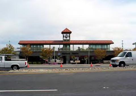
13 ALTERNATIVE 1 El CAMINO FOCUS RELOCATED & IMPROVED CALTRAIN STATION ALTERNATIVE 2 EAST-WEST CONNECTIONS
14 ALTERNATIVE 1 El CAMINO FOCUS PARKING GARAGE FOR CALTRAIN USERS ALTERNATIVE 2 EAST-WEST CONNECTIONS
15 ALTERNATIVE 1 El CAMINO FOCUS GRADE-SEPARATED CROSSINGS ALTERNATIVE 2 EAST-WEST CONNECTIONS
16 ALT. 1 El CAMINO FOCUS ALT. 2 EAST-WEST CONNECTIONS SIMILAR LEVELS OF DEVELOPMENT
17 HOW THE ALTERNATIVES DIFFER Circulation Alternative 1 : Focus on El Camino Real. Alternative 2: Focus on East-West avenues. Urban Design Alternative 1: Focus mixed-use and new areas of activity up and down El Camino Real from 25 th to 31 st Avenues. Alternative 2: Focus mixed-use and new areas of activity on eastwest streets and at major intersections. Parking Garages Alternative 1: Stand alone garage lined with two stories of retail at El Camino and 31 st. Alternative 2: Garage with new station circulation and plaza areas on ground floor, on El Camino near 28 th.
18 BUILDING TYPES Building Types found in both alternatives : Mixed Use (housing over retail or office) Residential (apartment or condominium) New Retail Development on Hillsdale Shopping Center Parking Lots New Caltrain Station Building Plaza/Open Space


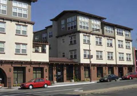
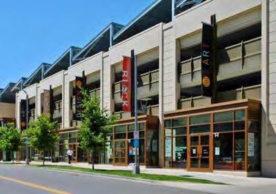
19 Palo Alto Oakland Redwood City Berkeley MIXED-USE (HOUSING OVER RETAIL/OFFICE)


")
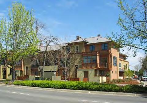
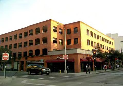
20 Palo Alto East Palo Alto Burbank Mountain View (Alt 2 only) RESIDENTIAL (APARTMENT OR CONDOMINIUM)


21 Walnut Creek Walnut Creek Redwood City Pleasant Hill NEW RETAIL DEVELOPMENT ON HILLSDALE PARKING LOTS

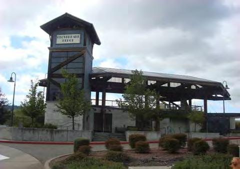
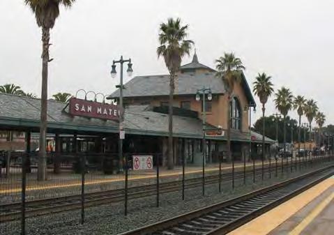
22 Downtown Belmont Cloverdale Mountain View NEW TRAIN STATION


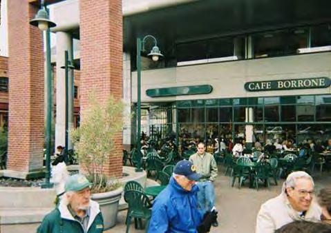
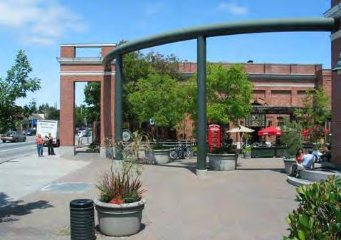
23 Menlo Park Menlo Park San Jose Emeryville PLAZA/OPEN SPACE
24 BUILDING TYPES BUILDING TYPES THAT DIFFER AMONG ALTERNATIVES Parking Garage Alternative 1: El Camino Focus Includes retail Alternative 2: East-West Connections No retail Office (only in Alternative 1 El Camino Focus)

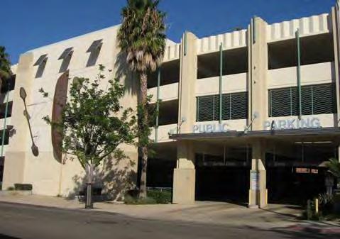
25 Pasadena Colorado ALTERNATIVE 1 Ventura Petaluma ALTERNATIVE 2 PARKING GARAGE


26 Mountain View Menlo Park Palo Alto Mountain View OFFICE (ALTERNATIVE 1 ONLY)
Note: Red text denotes additions/ changes from Dec 23, 2009 draft Page 1 of 12
 1. Concern noise/vibration levels generated by project will impact quality of life of people living in proximity to project. 1.1 Project should not create more noise/vibration than there is today 1.2 Vibration
III. Design Principles
 III. Design Principles The design of Bay Meadows Phase II has been guided by a series of Urban Design Principles. These principles, informed by consultant site analysis, City staff recommendations, and
ECR. el camino real master plan. settings and opportunities. The City of San Mateo SMWM. Adopted by the San Mateo City Council September 18, 2001
 ECR el camino real master plan settings and opportunities Adopted by the San Mateo City Council September 18, 2001 The City of San Mateo SMWM el camino real master plan settings and opportunities 1 executive
Physical Connectivity Do not have structures that physically divide the community more than it is divided today
 SECTION 0 & 1 SAN FRANCISCO ISSUES Caltrain & High Speed Rail service/stations Location of SF terminus (TTC and/or 4 th & King) and alignment must make sense from user perspective/greater ridership, and
el camino real master plan
 el camino real master plan Adopted by the San Mateo City Council September 18, 2001 The City of San Mateo SMWM el camino real master plan 0 executive summary page 001 1 issues and opportunities page 005
Installed Hardiness Zone 9b
 Installed 2003 Hardiness Zone 9b California State University at Sonoma Student Housing - Peteluma, CA Over 125 standard diameter greenscreen Column Trellis units are mounted to steel posts to create a
A. WHAT IS A GENERAL PLAN?
 I. Introduction A. WHAT IS A GENERAL PLAN? A general plan is the planning guideline for the future of a city. It contains goals and policies which regulate urban development, the protection of the natural
shown on the following page.
 ARCHITECTURE PLANNING URBAN DESIGN May 5, 2016 Ms. Tricia Schimpp Department of Community Development City of San Mateo 330 West 20th Avenue San Mateo, CA 94403-1388 RE: Hillsdale Terrace Dear Tricia:
Walnut Creek BART Station
 Walnut Creek BART Station Mixed Use Transit Oriented Project Design Review Commission Study Session May 17, 2006 Applicant: Walnut Creek Transit Lifestyles Associates Joint Venture: Transit Village Associates
DRAFT Concept Alternatives
 O c t o b e r 2016 DRAFT Concept Alternatives W a l n u t G e n e r a l P l a n U p d a t e a n d W e s t Va l l e y S p e c i f i c P l a n Contents WHAT IS THE GENERAL PLAN..........................................
Summary Community Workshop #1 Fruitvale San Antonio Senior Center Monday, March 23, :00-9:00 p.m.
 Summary Community Workshop #1 Fruitvale San Antonio Senior Center Monday, March 23, 2009 7:00-9:00 p.m. Workshop Format and Process The City of Oakland is preparing a Specific Plan that will help define
4 LAND USE DESIGNATIONS
 4 LAND USE DESIGNATIONS Chapter 4 describes the land use designations and densities that will implement the development vision for North Burlingame outlined in Chapter 3. Land use densities are described
2035 General Plan Update and Belmont Village Specific Plan. Joint Study Session with the City Council and Planning Commission April 12, 2016
 2035 General Plan Update and Belmont Village Specific Plan Joint Study with the City Council and Planning Commission April 12, 2016 Agenda 1. Welcome and Introductions 2. General Plan Update Status of
Northwest Rail Corridor and US 36 BRT Development Oriented Transit Analysis 4.4 STATION AREA FINDINGS
 4.4 STATION AREA FINDINGS Each station is different, and each one requires a separate set of recommendations based on the vision for the site. This section outlines an initial TOD strategy and recommendations
Exclusivel Listing Agent: BRUCE FRAZER Senior Vice President CA Lic:
 NEW RETAIL SPACE - WHEELER PLAZA Transit-Oriented Mixed Use Development Now Under Construction Premier Downtown San Carlos Location 10,274 SF 1245-1265 San Carlos Ave., San Carlos, CA Developed by KB Home
Chapter 3 Project Description
 Chapter 3 Project Description 3.1 OVERVIEW This Draft EIR evaluates the potential for impacts to the environment for two separate but linked proposed projects: the San Mateo Rail Corridor Transit-Oriented
Subject: Menlo Park Residents Deserve A Much Better Grade Separation Option
 March 13, 2018 To: Menlo Park City Council From: Dana Hendrickson Subject: Menlo Park Residents Deserve A Much Better Grade Separation Option The Menlo Park City Council believes it must soon decide where
920 BAYSWATER AVENUE PROJECT
 920 BAYSWATER AVENUE PROJECT VISUAL ASSESSMENT Prepared for the City of Burlingame Prepared by Circlepoint 46 S First Street, San Jose, CA 95113 June 2018 This page intentionally left blank. 920 Bayswater
Atlanta BeltLine Subarea 3 Master Plan Update
 Atlanta BeltLine Subarea 3 Master Plan Update April 14, 2018 Workshop Meeting 1 22 miles, connecting 45 neighborhoods 22 MILES of transit 46 MILES of streetscapes and complete streets 33 MILES of urban
CENTRAL ESTUARY PLAN AVISION FOR OAKLAND S WATERFRONT
 Central Estuary Plan A VISION FOR OAKLAND S WATERFRONT Specific Plan and Environmental Assessment Presentation to the Parks and Recreation Advisory Commission December 9, 2009 This Afternoon s Presentation
Bay Meadows Specific Plan Amendment - Phase II Overview. I. Phase II Overview. November 7, 2005 I - 1
 I. Phase II Overview November 7, 2005 I - 1 Explanatory Note This Specific Plan Amendment amends the Bay Meadows Specific Plan adopted by the San Mateo City Council on April 22, 1997. The original Specific
Area & Master Plan Policies for PA Hillsdale Shopping Center North Block Redevelopment
 Area & Master Plan Policies for PA 14-103 Hillsdale Shopping Center North Block Redevelopment Future growth and redevelopment of the shopping center is guided by the following relevant planning documents:
Dumbarton Transportation Corridor Study
 Dumbarton Transportation Corridor Study SPD&S Committee August 2, 2017 Agenda Item # 4 Two Bridges 2 Complex Corridor 3 Headlines Corridor requires phased improvements Solutions require consensus, other
Meeting Purpose & Agenda
 Meeting Purpose & Agenda Meeting Purpose: To provide a summary of the results of the Downtown Parks Site Assessment and Feasibility Study By recommendation, provide direction to staff on which City-owned
Community Working Group Workshops - Workshop Summary September TOD Corridor Strategy and Access Planning Study. Workshop Introduction
 Community Working Group Workshops - Workshop Summary September 11-13 2018 TOD Corridor Strategy and Access Planning Study With VTA s BART Phase II (the Study), VTA seeks to build upon existing transportation
Mount Dennis Mobility Hub Study Public Meeting December 12 th, :30pm 9:30pm York Memorial Collegiate, Cafeteria 2690 Eglinton Avenue West
 Mount Dennis Mobility Hub Study Public Meeting December 12 th, 2012 6:30pm 9:30pm York Memorial Collegiate, Cafeteria 2690 Eglinton Avenue West MEETING SUMMARY On December 12 th, 2012, over 89 people participated
Discussion Questions - Summary. 1. What do you value most about the area and think needs to be preserved by the Plan?
 Community Meeting #1 Discussion Questions - Summary 1. What do you value most about the area and think needs to be preserved by the Plan? Architectural Retain character through preservation of historical
NOTICE OF PREPARATION OF ENVIRONMENTAL IMPACT REPORT
 NOTICE OF PREPARATION OF ENVIRONMENTAL IMPACT REPORT TO: State Clearinghouse, Responsible and Trustee Agencies, and Other Interested Parties DATE: May 18, 2017 SUBJECT: Notice of Preparation of Environmental
September 30, 2014 Ms. Lorraine Weiss Department of Community Development City of San Mateo 330 West 20th Avenue San Mateo, CA
 ARCHITECTURE PLANNING URBAN DESIGN September 30, 2014 Ms. Lorraine Weiss Department of Community Development City of San Mateo 330 West 20th Avenue San Mateo, CA 94403-1388 RE: Station Park Green Dear
Community Meeting US 101/Peninsula Avenue Interchange Project JUNE 25, 2015
 Community Meeting US 101/Peninsula Avenue Interchange Project JUNE 25, 2015 Project Team Gary Heap, Engineering Division Manager Tracy Scramaglia, Senior Engineer Ramesh Sathiamurthy, AECOM Peter DeStefano,
Michigan City Alternative Analysis Realignment Study. Progress Status Update Report Presentation to City Council February 1, 2012
 Michigan City Alternative Analysis Realignment Study Progress Status Update Report Presentation to City Council Project Web Site Project Web Site is Active www. emichigancity.com Click on NICTD logo at
Citizen Advisory Committee Meeting #3.2
 Citizen Advisory Committee Meeting #3.2 August 10, 2016, 7:00 p.m. to 9:00 p.m. Police Department Conference Room, 7301 Hanna Street, Gilroy, CA 95020 Meeting Summary I. Call to Order Members present:
TASK FORCE MEETING #6 SUMMARY
 TASK FORCE MEETING #6 SUMMARY CITY OF REDWOOD CITY INNER HARBOR SPECIFIC PLAN Tuesday, January 14, 2013 7:00 P.M. 9:30 P.M. Seaport Conference Center, 459 Seaport Court, Redwood City, CA 94063 I. WELCOME
Proposed Land Use Concept
 Proposed Land Use Concept Proposed Land Use Concept Change Areas Proposed Land Use Concept Key Features Consolidate auto sales and services north of Ygnacio Valley Rd, with a more compact footprint Facilitate
Historic Resources. San Mateo has a Historic Building Survey that identified roughly 200 historically significant
 Historic Resources City of San Mateo Planning Division Community Development Department 330 West 20 th Avenue www.cityofsanmateo.org San Mateo, CA 94403 planning @cityofsanmateo.org Updated: March 20,
Isabel Neighborhood Plan: Alternatives
 Isabel Neighborhood Plan: Alternatives Presented by: Lori Parks, Associate Planner February 2, 2015 Agenda 1. Background on BART to Livermore 2. Isabel Neighborhood Plan 3. Alternative Scenarios 4. General
Firm Background and Contact Information. Interest, Availability and Commitment
 TABLE OF CONTENTS T A B L E O F C O N T E N T S Section 1 Firm Background and Contact Information Section 2 Background o o o Key Personnel Background Listing of Training Completed Proof of Training Section
FRUITVALE TRANSIT VILLAGE (Phase 2) Residential Project
 Residential Project") FRUITVALE TRANSIT VILLAGE (Phase 2) Residential Project DEVELOPER: SIGNATURE PROPERTIES ARCHITECT: HKIT ARCHITECTS April 23, 2010 TABLE OF CONTENTS 3 Vision 4 Description of Site 5 Guiding Concepts 6
FRUITVALE TRANSIT VILLAGE (Phase 2) Residential Project DEVELOPER: SIGNATURE PROPERTIES ARCHITECT: HKIT ARCHITECTS April 23, 2010 TABLE OF CONTENTS 3 Vision 4 Description of Site 5 Guiding Concepts 6
Port Credit Local Advisory Panel October 20 th Meeting
 Port Credit Local Advisory Panel October 20 th Meeting Focus Of This Evening s Meeting: 1. Hurontario Main Street Higher Order Transit Study 2. Port Credit Mobility Hub & GO Station Parking Structure Study
Getting Started On Your Green Infrastructure (GI) Plan
 Plan") Getting Started On Your Green Infrastructure (GI) Plan Peter Schultze-Allen EOA Inc. Annual SCVURPPP C3 Workshop June 16, 2015 Presentation Outline MRP 2.0 C.3.j (GI) requirements GI Framework elements
Getting Started On Your Green Infrastructure (GI) Plan Peter Schultze-Allen EOA Inc. Annual SCVURPPP C3 Workshop June 16, 2015 Presentation Outline MRP 2.0 C.3.j (GI) requirements GI Framework elements
RESEDA - WEST VAN NUYS COMMUNITY PLAN
 RESEDA - WEST VAN NUYS COMMUNITY PLAN Executive Summary As part of the initial outreach effort, the Department of City Planning hosted two workshops for the Reseda-West Van Nuys Community Plan Area during
DRAFT Civic Center Station Area Plan. Executive Summary
 DRAFT Civic Center Station Area Plan Executive Summary This project is funded in part through the Metropolitan Transportation Commission s Station Area Planning Program. The preparation of this report
Kenilworth Landscape Design Community Workshop. June 13, 2015
 Kenilworth Landscape Design Community Workshop June 13, 2015 1 Meeting Agenda 8:30 9:00 am: Project presentation 9:00 11:00 am: Small group / table activities 11:00 11:30 am: Reporting and next steps 11:30
Freightway Site Redevelopment Study
 Freightway Site Redevelopment Study Public Meeting 1 June 12, 2017 1 Introduction Check project website for updates: www.scarsdale.com/fw Send Comments to: freightwaystudy@scarsdale.com 2 Steering Committee
Ivywild On The Creek PRELIMINARY CREEK DISTRICT MASTER PLAN
 Ivywild On The Creek PRELIMINARY CREEK DISTRICT MASTER PLAN Introduction: Rejuvenating an extraordinary Creekside neighborhood THE CREEKSIDE DISTRICT The Ivywild On The Creek Neighborhood District Master
Chapter 1.0 Introduction
 Chapter 1.0 Introduction 1.1 Background The North Metro commuter rail line is part of the RTD FasTracks regional transit system expansion program to build more than 100 miles of rail transit throughout
April 21, 2007 CCRP Workshop Summary
 April 21, 2007 CCRP Workshop Summary Group 1 1. Reuse around BART with a lot of housing and jobs 2. Greenway around creek 3. Transit and auto connection all through the site from Kirker Pass to Port Chicago
Colorado Station 2.0
 Colorado Station 2.0 Spring 2016 MURP Workshop UC Denver Ellen Ittelson Gregory Meek Megan Yonke Katelyn Puga Nathan Silverstein Claire Dalby Matthias Helfen Mark Richardson Jake Schmitz Gaby Hart Lauren
Dumbarton Transportation Corridor Study. JPB Board of Directors September 7, 2017
 Dumbarton Transportation Corridor Study JPB Board of Directors September 7, 2017 Two Bridges 2 Complex Corridor 3 Context JPB led previous Dumbarton Rail design and environmental analysis via MOU Potential
Por favor, levanten la mano si necesita traduccion en espanol Please raise your hand if you need Spanish translation
 FEDERAL BOULEVARD CORRIDOR WIDE STUDY PUBLIC MEETING #1 APRIL 27, 2016 Por favor, levanten la mano si necesita traduccion en espanol Please raise your hand if you need Spanish translation HDR DESIGN WORKSHOP
Agenda Summary December 11, 2017
 Agenda Summary December 11, 2017 Agenda Item No. 5 VT 108 Roadway Master Plan for Mountain Road Village (Including the Luce Hill / Rt.100 Intersection) Summary: David Saladino, vhb Transportation Systems
José Campos Manager of Planning and Design Review SPUR San José Symposium October 12, 2018
 1 Transbay: Freeways to New Ways José Campos Manager of Planning and Design Review SPUR San José Symposium October 12, 2018 2 Transbay freeway land pre-1989 3 1989 Loma Prieta Earthquake 4 TRANSBAY c.
Lehigh Acres Land Development Regulations Community Planning Project
 Lehigh Acres Land Development Regulations Planning Effort Summary In July, 2010 Commissioner Frank Mann invited the Lehigh Acres community to start discussing how to achieve their recently adopted community
Coast Highway Oceanside, California
 Coast Highway Oceanside, California Coast Highway Plan Zones What We ve Heard - Walkable/Bikeable Community (Senior and Child Friendly) -Wider Sidewalks -Street Trees -Traffic Calming -Bike Lanes -Paseos
RIVERSIDE, Newton MA June 9, 2011
 June 9, 2011 TONIGHT S AGENDA: 1.Project Update (5 min.) 2.Master Plan Update (10 min.) 3.Environmental Update (5 min.) 4.Traffic Plan Update (25 min.) Questions PROJECT STATUS UPDATE Responding / Clarifying
SLIDE TITLE TRANSIT-ORIENTED DEVELOPMENT PLAN RED-PURPLE BYPASS STUDY AREA PUBLIC MEETING #2 RED AND PURPLE MODERNIZATION. RPM TOD Plan Update
 SLIDE TITLE TRANSIT-ORIENTED DEVELOPMENT PLAN RED-PURPLE BYPASS STUDY AREA PUBLIC MEETING #2 RED AND PURPLE MODERNIZATION 1 SLIDE TITLE AGENDA Project Introduction TOD s and Development Trends Real Estate
Community Meeting #2.1
 Community Meeting #2.1 Thursday, October 20, 2016, 7:00 p.m. to 9:00 p.m. Eliot Elementary School, 475 Old Gilroy Street, Gilroy, CA 95020 Meeting Summary The City of Gilroy held its third community meeting
Recent experience on projects using Best Management Practices and Stormwater Detention:
 August 16, 2010 Ms. Jill Bicknell Assistant Program Manager EOA, Inc. 111 West Evelyn Ave., Suite 110 Sunnyvale, CA 94086 Subject: RFQ: Santa Clara Valley Urban Runoff Pollution Prevention Program Professional
Parking Garage Site Selection Committee Final Report October 15, 2012
 Parking Garage Site Selection Committee Final Report October 15, 2012 Executive Summary Recommend a Short-List of Sites for Further Review: 1. Explore the Possibility of a Private/ Public Partnership 2.
V. Urban Design A. INTRODUCTION B. CITY IMAGE
 V. Urban Design A. INTRODUCTION Urban design refers to the physical form and development of a city from the individual neighborhood to the overall city scape. In the largest sense, urban design encompasses
TOWN COUNCIL / PLANNING COMMISSION
 Workshop #3 TOWN COUNCIL / PLANNING COMMISSION January 20, 2011 Consultant Team In Attendance Tonight BMS Design Group Nevada City and San Francisco Michael Smiley, AICP, ASLA Partner-in-Charge Nancy L.
1: INTRODUCTION 1 2: COMMUNITY PROCESS AND OUTREACH 11 3: EXISTING CONDITIONS 17
 Table of Contents 1: INTRODUCTION 1 Regional and Local Setting 3 Specific Plan Area 5 Purpose and Intent of the Plan 6 Key Community-Generated Design Goals 6 Previous Planning Efforts 7 Statutory Requirements
Dumbarton Transportation Corridor Study. Stakeholder/Public Meetings August 16, 2017
 Dumbarton Transportation Corridor Study Stakeholder/Public Meetings August 16, 2017 Two Bridges 2 Complex Corridor 3 Headlines Corridor requires phased improvements Solutions require consensus, other approvals
WELCOME and introduction
 1 WELCOME and introduction Mobility Hub Locations within Burlington STUDY OVERVIEW STUDY OBJECTIVES The City of Burlington is developing four Area Specific Plans, one for each of Burlington s Mobility
Reinventing Miner Avenue as a
 Reinventing Miner Avenue as a Complete Street Reinventing Miner Avenue as a Complete Street Agenda Project Overview / Introductions Previous Meeting Recap Economic Considerations Opportunities & Constraints
NORTH LAKE SPECIFIC PLAN AREA
 NORTH LAKE SPECIFIC PLAN AREA June 21, 2018 WELCOME Workshop Agenda Introduction Provide information about the program and introduce the team Background Information Share information about the North Lake
Community Open House #2 June 12 th, 2018, 5:30 7:00 PM
 Community Open House #2 June 12 th, 2018, 5:30 7:00 PM Raymond Santiago, GGBHTD Project Manager Consultant Team: Adam Dankberg, Kimley-Horn and Associates Lisbet Sunshine, Civic Edge Consulting 1 Open
WELCOME 4201 E. ARKANSAS AVENUE PROPERTY COMMUNITY DISCUSSION
 WELCOME 4201 E. ARKANSAS AVENUE PROPERTY COMMUNITY DISCUSSION Salem United Church of Christ June 7, 2018 AGENDA Introduction Existing Conditions CDOT s Next Steps Proposed Zoning Overview Transportation
Subject: 30 Otis Street, Evaluation of Shadow on Proposed 11th and Natoma Park
 Date: September 5, 2018 To: Recreation and Park Commission Capital Committee Through: Philip A. Ginsburg, General Manager Toks Ajike, Director, Capital & Planning Division From: Brian Stokle, Planner,
N Watt Avenue Corridor Plan. STOREFRONT WORKSHOP May 15-17, 2007
 N Watt Avenue Corridor Plan STOREFRONT WORKSHOP May 15-17, 2007 Workshop Overview May 15 12 & 2 pm General Overview/3D Modeling 4 pm Special Topic: Market Study 6 pm Special Topic: McClellan May 16 12
Figure BE-4: Urban Form - Corridors. Urban Form and Land Use. Page BE-24 Redwood City General Plan S A N F R A N C I S C O B A Y.
 and Land Use Bird Island S A N F R A N C I S C O B A Y Foster City Bair Island Belmont Greco Island San Carlos Veterans Blvd. El Camino Real Broadway Middleeld Rd. Menlo Park Woodside Rd. Features El Camino
Mariposa Lakes. Planned Community. Project Overview. Stockton, CA
 Planned Community Stockton, CA Project Overview March 2007 Summary of Proposed Community is a master-planned community proposed for development on approximately 3,810 acres in southeast Stockton. In 2004,
BROOKLYN PARK / 85TH AVE LRT STATION CDI DEVELOPMENT GUIDELINES DRAFT
 August 2018 Page intentionally left blank The Brooklyn Park Library adjacent to the 85th Ave LRT Station Area. OVERVIEW The Blue Line LRT Extension / Bottineau corridor offers a unique opportunity to leverage
 Community Workshop #2 December 4, 2014 Team Tonight s Agenda 6:00 pm Welcome! 6:05 pm The Future of Downtown Tustin Ideas, Strategies and Recommendations 6:35 pm Questions and Comments 6:50 pm Open
Mary Hills Nature Area. Roadway Lighting. The Minneapolis Clinic of Neurology Courage Kenny Rehabilitation Institute
 PUBLIC REALM IMPROVEMENTS Mary Hills Nature Area Enhanced Programming Glenview Terrace Valley View Roadway Lighting Enhanced Streetscape Trail Lighting / Roadway Lighting Wayfinding Public Art The Minneapolis
PLANNING COMMISSION STAFF REPORT
 PLANNING COMMISSION STAFF REPORT FOR THE PLANNING COMMISSION MEETING OF AUGUST 4, 2014 AGENDA ITEM F1 AND G1 EIR SCOPING SESSION AND STUDY SESSION LOCATION: 1300 El Camino Real APPLICANT AND PROPERTY OWNER:
Mississippi Drive Corridor Revitalization. A DestinationTransportation Project...
 Mississippi Drive Corridor Revitalization A DestinationTransportation Project... Mississippi Drive Corridor Revitalization Welcome! Tonight s Agenda: Further define the Scope of the Project Discuss the
EXISTING TOWNHOUSE. What s working & What s not?
 What s working & What s not? Distance from the sidewalk/street to the building Landscape vs. Hardscape in front of the building Porches, stoops, steps, and entries Residential vs. contemporary character
Dumbarton Rail Corridor. Project Scoping Meeting Nov 15, :15 PM City of Newark Nov 16, :15 PM City of Menlo Park
 Dumbarton Rail Corridor Project Scoping Meeting Nov 15, 2006 7:15 PM City of Newark Nov 16, 2006 7:15 PM City of Menlo Park 1 Presentation Overview I. Introduction History of the Project II. III. Purpose
City Council Special Meeting AGENDA ITEM NO. C.
 City Council Special Meeting AGENDA ITEM NO. C. DATE: 01/04/2019 TO: Honorable Mayor and City Council Members SUBJECT: Transit Villages Specific Plan project Study Session (Development Services Director
Transportation Working Team Duane Diggs, Co-Chair (VOICE Buffalo) Kelly Dixon, Co-Chair (GBNRTC) Paul Ray, Facilitator (UB Regional Institute)
 Kelly Dixon, Co-Chair (GBNRTC) Paul Ray, Facilitator (UB Regional Institute)") towards a more sustainable Buffalo Niagara Transportation Working Team Duane Diggs, Co-Chair (VOICE Buffalo) Kelly Dixon, Co-Chair (GBNRTC) Paul Ray, Facilitator (UB Regional Institute) Agenda Welcome,
towards a more sustainable Buffalo Niagara Transportation Working Team Duane Diggs, Co-Chair (VOICE Buffalo) Kelly Dixon, Co-Chair (GBNRTC) Paul Ray, Facilitator (UB Regional Institute) Agenda Welcome,
New Partners for Smart Growth Conference February 5, 2010
 Dan Stroh, Planning Director City of Bellevue Planning and Community Development Bellevue, WA New Partners for Smart Growth Conference February 5, 2010 Summary of Project Long-range plan update for Bel-Red
People who are members of historically disenfranchised racial, ethnic, cultural, and other identity groups are encouraged to apply.
 CALL TO ARTISTS REQUEST FOR QUALIFICATIONS CITY OF TACOMA MUNICIPAL ART PROGRAM East 64 th Streetscape, Tacoma, WA APPLICATION DEADLINE October 10, 2018, 11:59pm BUDGET $72,000, all-inclusive SUMMARY The
Gold Line Bus Rapid Transit Transit Oriented Development (BRTOD) Helmo Station Area Plan
 Helmo Station Area Plan") Appendix F Gold Line Bus Rapid Transit Transit Oriented Development (BRTOD) Helmo Station Area Plan Introduction and Purpose of the Plan The Gold Line Bus Rapid Transit facility is an eleven-mile dedicated
Appendix F Gold Line Bus Rapid Transit Transit Oriented Development (BRTOD) Helmo Station Area Plan Introduction and Purpose of the Plan The Gold Line Bus Rapid Transit facility is an eleven-mile dedicated
Chapter 4. Linking Land Use with Transportation. Chapter 4
 Chapter 4 Linking Land Use with Transportation Chapter 4 59 Chapter 4 Linking Land Use with Transportation Community Design and Transportation Program Introduction Since the 1950s, the predominant development
Green Gables. April 24, 2013
 Green Gables Preliminary and Final Plat April 24, 2013 Development Team Green Gables Development Corporation (Owner/Developer) DTJ Design (Planner/Landscape Architect) Enertia Consulting Group (Civil Engineer)
City of Fairfax, Virginia City Council Work Session
 City of Fairfax, Virginia City Council Work Session Agenda Item # 12a City Council Meeting 5/8/2018 TO: FROM: SUBJECT: Honorable Mayor and Members of City Council Robert Sisson, City Manager Request of
WEST OAKLAND SPECIFIC PLAN Final Plan. 2. Vision & Goals. 2.1 Community-Based Goals and Objectives
 WEST OAKLAND SPECIFIC PLAN Final Plan 2. Vision & Goals 2.1 Community-Based Goals and Objectives June 2014 2: Vision & Goals The vision of the West Oakland Specific Plan is to see this remarkable community
Sewanee Village + Request for Builder/Developer Proposals
 Sewanee Village + Request for Builder/Developer Proposals Contact: Frank X. Gladu Special Assistant to the Vice Chancellor University of the South 735 University Ave Version 3 Sewanee TN 37383 Released:
City of San Mateo General Plan Circulation Element. Adopted October 18, 2010
 City of San Mateo General Plan Circulation Element. Adopted October 18, 2010 TRANSIT (pp III-20 to III-21) Exhibit A - Item 20 Excerpt from 2010 Downtown Plan Update and enacting Resolution C 3.4: Hillsdale
Public Consultation Summary: Lakeview Place Making Workshop January 30, 2008.
 Page 1 of 11 Public Consultation Summary: Lakeview Place Making Workshop January 30, 2008. 1.0 Introduction: On January 30, 2008 the City of Mississauga, in conjunction with the consulting team of Brook
BeltLine Corridor Environmental Study
 BeltLine Corridor Environmental Study Citywide Conversation on Transit and Trails April 2, 2009 Agenda & Introductions Introductions Environmental Study Process Overview of the BeltLine Project BeltLine
Union Station Master Plan Task 3 Update
 Union Station Master Plan Task 3 Update June 18, 2014 1 2 3 4 5 6 7 8 9 10 11 12 13 14 15 16 17 18 19 20 21 22 23 24 25 26 27 2012 2013 2014 A S O N D J F M A M J J A S O N D J F M A M J J A S O Task 1`
Promoting Economic Development Through Upfront SEPA Review: Lessons from South Downtown Tacoma
 Promoting Economic Development Through Upfront SEPA Review: Lessons from South Downtown Tacoma 1 This session will focus on the City of Tacoma s South Downtown Subarea Plan and associated Non-Project SEPA
Tonight s Agenda. 7:45 p.m. Next Steps 8:00 p.m. Close
 Community Workshop #3 January 28, 2016 Team Tonight s Agenda 6:00 p.m. Welcome and Introductions! 6:15 p.m. Draft Specific Plan Overview Project Process Update Vision and Objectives Overview Key Findings
RESEDA - WEST VAN NUYS COMMUNITY PLAN UPDATE WORKSHOP
 Welcome Agenda 6:00 P.M. to 8:00 P.M. Welcome Community Plan Update Overview Presentation Table Discussions: Preserving Residential Neighborhoods Commercial Corridors Mobility Parks and the Public Realm
2. Form and Character. 2.1 Introduction. 2.2 The Downtown Addition Plan. 2.1 Introduction
 2.1 Introduction 2.1 Introduction This section of the Specific Plan describes and illustrates the desired form, character and uses of the Downtown Addition and explains the underlying design principles.
SUBJECT: PREDEVELOPMENT PLAN REVIEW OF PROJECT LOCATED AT 2632 EAST WASHINGTON BOULEVARD ('ST. LUKE MEDICAL CENTER')
") TO: FROM: Honorable Mayor and City Council Planning & Community Development Department SUBJECT: PREDEVELOPMENT PLAN REVIEW OF PROJECT LOCATED AT 2632 EAST WASHINGTON BOULEVARD ('ST. LUKE MEDICAL CENTER')
TO: FROM: Honorable Mayor and City Council Planning & Community Development Department SUBJECT: PREDEVELOPMENT PLAN REVIEW OF PROJECT LOCATED AT 2632 EAST WASHINGTON BOULEVARD ('ST. LUKE MEDICAL CENTER')
12600 S Existing Conditions
 STUDY AREA BOUNDARY Study Area Boundary Study Area Context The District Riverton Meadows Vista Station Mountain View Village Market Center 2 Mile Radius 12600 S Existing Conditions 12600 S is a river of
Summary Community Workshop #6 Beacon Day School Saturday, November 14, :00 a.m. 12:00 p.m.
 Summary Community Workshop #6 Beacon Day School Saturday, November 14, 2009 9:00 a.m. 12:00 p.m. Workshop Format and Process The City of Oakland is preparing a Specific Plan that will help define and determine