LOWELL & EVANS. Public Meeting #1. Green Infrastructure Water Quality Community Space. August 17th, 2017
|
|
|
- Grace Walker
- 5 years ago
- Views:
Transcription
1 Public Meeting #1 August 17th, 2017
2


3 Welcome! Councilman Kevin Flynn, District 2 City and County of Denver, Public Works; Water Quality. Sarah Anderson WQ Program Manager Brian Wethington WQ Project Manager Ashlee Grace - Senior Planner Consultant Team Chris Kroeger Muller Engineering Ryan Taylor Muller Engineering Paul Thomas Stream Design, Landscape Architects Carly Gelatt Stream Design, Landscape Architects

 Our")


4 Agenda: Presentation (About 15 Min.) Our Stormwater System Why is Water Quality Necessary? What does Green Infrastructure look like? Project Site & Key Considerations Open House Discussion (35 Min.) Share back of key issues from discussion (10 Min.)
5 Our Stormwater System


6 Increasing Impervious Area 47% of Denver* is currently covered in impervious surfaces Source: DRCOG LiDAR Data 57% of Denver* is projected to have impervious cover by 2020 based on future land use Source: CCD Drainage Master Plan, 2014 Photo Source: Denver Post, 3/21/15
7 Green Infrastructure Planning Objectives 1. Data Driven: Prioritize basins with greatest WQ needs based on data 2. Strategic Prioritization: Identify large & site-scale GI projects by using Scorecard criteria 3. Proactive: Address wet and dry weather discharges 4. Meet Multiple City Goals: Work with other city agencies to maximize collaboration opportunities & OPM (DPR, CPD, DEH, Transportation & Mobility) Regional: Hampden Heights Site scale: Brighton Boulevard


8 Green Infrastructure Planning REGIONAL SCALE Asbury & Tejon 38 th & Holly High Line Canal SITE SCALE 21 st & Broadway Lowell & Evans Federal Blvd Total Treatment: 937 acres Prioritized from Scorecard and Metrics Machine Inform future policies, project budges, etc. Key for continued program improvement
9 Why Green Infrastructure?

10 What does Green Infrastructure Look Like?
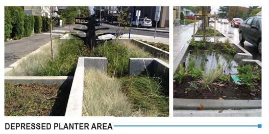
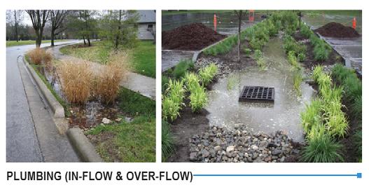
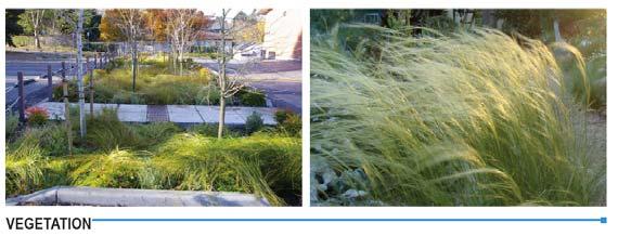
11 Green Infrastructure Design


12 Project Context Project was identified through Community input Water Quality analysis Strong community support Multiple Benefits Community Space Water Quality Intersection improvements Depaving
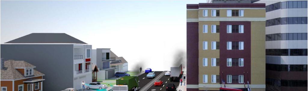
13 Project Site A. Lowell & Evans looking East
14 Project Site B. Warren Street looking North C. Warren & Lowell Intersection looking North


 Technical")
")
15 Project Site Site Information: Approximately 10,000 SF of impervious area 8-inch sanitary line and manhole Water main New bike lanes Known Site Considerations: Maintain parking and waste pick-up at for adjacent property owners Protect and preserve utilities, sanitary and water services Safety (lighting and site-lines) Technical Considerations: Provide area to treat ~2 acres of stormwater runoff (from Iliff, Lowell, Marshall, & Evans) Provide area for community space
16 Thank you! Break-Out sessions; 2 to 3 stations, each one is the same What are we looking for? What do we need to know about this site? History of site, community impacts, etc. What do you want to see in the future? Types of compatible uses, things you d like to see, your favorite community spaces, anything you d like us know. Write down feedback on boards, flip-charts, or comment cards 35 Minutes Consultant or City Representative will readout key feedback and issues at the end of the meeting Public Meeting #2 planned for November 2017
17 What We Heard. More information or feedback? Brian Wethington phone: (720) Ashlee Grace phone: (720)
LOWELL & EVANS. Public Meeting #3. Green Infrastructure Water Quality Community Space. April 10th, 2018
 Public Meeting #3 April 10th, 2018 Welcome! Councilman Kevin Flynn, District 2 City and County of Denver, Public Works; Water Quality. Sarah Anderson WQ Program Manager Brian Wethington WQ Project Manager
COMMUNITY MEETING: ROUND 3. Ill' PUBLIC WORKS outreach systems study Planning Design»Action
 l.,,.l DENVER COMMUNITY MEETING: ROUND 3 10 resiliency planning Iupper montclair education J stormwater Ill' PUBLIC WORKS Planning Design»Action TONIGHT'S AGENDA 10 resiliency planning Iupper montclair
Marion Street Green Infrastructure Project. Whittier Neighborhood Community Meeting April 18, 2018
 Marion Street Green Infrastructure Project Whittier Neighborhood Community Meeting April 18, 2018 Agenda Water quality and green infrastructure Overview: Marion Street stormwater project Green infrastructure
South Federal corridor improvements
 South Federal corridor improvements Welcome to the South Federal Green Infrastructure Project Public Open House October 25, 2018 The City and County of Denver Department of Public Works, in collaboration
MALLETTS BAY INITIATIVE
 MALLETTS BAY INITIATIVE Stormwater Management & Transportation Scoping Study January 19, 2017 Project Team Bryan Osborne Director of Public Works Sarah Hadd Director of Planning & Zoning Marshall Distel
WELCOME 4201 E. ARKANSAS AVENUE PROPERTY COMMUNITY DISCUSSION
 WELCOME 4201 E. ARKANSAS AVENUE PROPERTY COMMUNITY DISCUSSION Salem United Church of Christ June 7, 2018 AGENDA Introduction Existing Conditions CDOT s Next Steps Proposed Zoning Overview Transportation
INTEGRATION PLAN. Harvard Gulch
 INTEGRATION PLAN Harvard Gulch August 31, 2016 Related Projects and Partners Tonight s Agenda 1. Welcome & Meeting Purpose 2. Other Project Updates Floodplain Study Urban Waterways Study 3. Purpose of
2017 General Obligation Bond
 2017 General Obligation Bond Presentation of Public and Council Projects to the Transportation & Mobility Stakeholder Committee April 13, 2017 Agenda Deferred Maintenance Project Development Process Projects
Tech Innovations in Parks Tuesday August 1st 1:45-3:00
 Tech Innovations in Parks Tuesday August 1st 1:45-3:00 S P E A K E R S Moderator: Kevin O'Hara, Vice President of Urban and Government Affairs, National Recreation and Park Association (NRPA) Elizabeth
NOTES FROM PUBLIC MEETING #3 AUGUST 30, 2017
 NOTES FROM PUBLIC MEETING #3 AUGUST 30, 2017 1. MEETING SUMMARY & MAIN POINTS The community meeting consisted of one overview presentation and two small group discussions of preferred approaches to Hale
Reconnecting New Haven: Downtown Crossing
 Reconnecting New Haven: Downtown Crossing Phase 2 Update Introduction to Phase 3 November 16, 2017 City of New Haven, Connecticut Toni N. Harp, Mayor Reconnecting New Haven Introduction Project Overview
Staff Report Bourbon County Joint Planning Office SPECIAL MEETING September 4, 2018
 Staff Report Bourbon County Joint Planning Office SPECIAL MEETING September 4, 2018 Case Number: DVP 18-05 FINAL Applicant: Josh Cummins Location: Arlington Drive. Request: Car Dealer Parking Lot Zoning:
Monroe Street Reconstruction Planning
 Monroe Street Reconstruction Planning April 2014 Monroe Street Reconstruction Project What to expect this evening Welcome and introductions Project scope, timeline and process Including past planning efforts
Burton Station Village Community Meeting February 26, 2014
 February 26, 2014 SGA Plan Overview Recent announcements by the City of Norfolk regarding the closure of Lake Wright Golf Course and retail development proposals Update on infrastructure improvement plans
Denver Moves: Transit Task Force
 Insert transit picture Denver Moves: Transit Task Force Meeting #8 October 5, 2017 1. Welcome & Introductions Opening remarks and housekeeping Task Force and audience introductions Upcoming events and
City of East Point Comprehensive Floodplain Management Program
 City of East Point Comprehensive Floodplain Management GAFM 2012, 7 th Annual Technical Conference Reza Aral, CFM, CPESC (City of East Point, GA) Shayne Wood, P.E. (CDM Smith) March, 28, 2012 Agenda Overview
Phase I Redevelopment Plan. First Community Meeting
 Hoboken Terminal and Yard Phase I Redevelopment Plan First Community Meeting May 31, 2011 One Hudson Place Phase I Redevelopment Plan Redevelopment Plan First Community Meeting Agenda 1. Redevelopment
Portland International Airport Storm Water Master Plan June 5, Susan Aha Water Quality Manager
 Portland International Airport Storm Water Master Plan June 5, 2013 Susan Aha Water Quality Manager 1 Presentation Overview What is storm water and why is it important to manage Regulatory framework for
Successful Green Infrastructure Planning: A Micro-Scale Modeling and Field Investigation Approach
 Successful Green Infrastructure Planning: A Micro-Scale Modeling and Field Investigation Approach Hazem Gheith and Vinnie Treatment, Water Division, ARCADIS-US Hunter Kelly, Department of Sewage and Drainage,
DOMINION BOULEVARD CORRIDOR STUDY AND ECONOMIC DEVELOPMENT STRATEGIC PLAN A MODEL FOR CHESAPEAKE S FUTURE
 DOMINION BOULEVARD CORRIDOR STUDY AND ECONOMIC DEVELOPMENT STRATEGIC PLAN A MODEL FOR CHESAPEAKE S FUTURE Overview I. Draft Plan Process II. Draft Plan Overview a. Market Analysis b. Master Land Use Plan
Community Workshop November 19, 2014
 Community Workshop November 19, 2014 Agenda Welcome and Introduction What is a General Plan? About the General Plan Update Our General Plan Topics to be included in the Update Update process Opportunities
Planning & Designing for Green Infrastructure: Implementation in the Public Right-of-way
 Planning & Designing for Green Infrastructure: Implementation in the Public Right-of-way Presenters Terra Ishee, Acting Director, Pedestrian Projects Group, NYC DOT Rosanna Collars, Urban Planner & Designer,
Welcome to the LYNX Blue Line Extension Transit Station Area Plans Public Workshop No. 3. Presentation will begin at 6:00 P.M.
 Welcome to the LYNX Blue Line Extension Transit Station Area Plans Public Workshop No. 3 Presentation will begin at 6:00 P.M. Meeting Agenda Blue Line Extension (BLE) Project Update LYNX Blue Line Extension
Chesapeake Bay Watershed Restoration Jessica Seipp, PMP Water Resources Department Manager
 Chesapeake Bay Watershed Restoration Jessica Seipp, PMP Water Resources Department Manager Bite of Science Loyola University, Baltimore, MD November 13, 2017 Agenda Who am I and where do I work? How did
Physical Approaches to Flood Mitigation
 Physical Approaches to Flood Mitigation ational Academy of Sciences /19/2017 Chicago Area Before Development Widespread Flooding Waterways and Marshes Absorbent Ground Early settlers came to this location
Cobb County Design Guidelines Mableton Parkway & Veterans Memorial Highway Community Design Workshop January 12, 2017
 Community Design Workshop January 12, 2017 Agenda Opening Remarks / Introductions Scope of Work Existing Conditions Key Issues / Opportunities VPS Summary Draft Vision & Goal Statement Implementation Concepts
WELCOME TO OPEN HOUSE TWO November 28, 2018
 Langstaff Road Weston Road to Highway 7 Class Environmental Assessment Study WELCOME TO OPEN HOUSE TWO November 28, 2018 Please sign in and join our mailing list Study Overview York Region is conducting
Project phasing plan (if applicable) 12 copies of site plan
 12 copies of site plan") SITE PLAN REVIEW PERMIT APPLICATION City of Grand Haven, 11 N. Sixth Street, Grand Haven, MI 49417 Phone: (616) 847-3490 Fax: (616) 844-2051 Website: www.grandhaven.org 1. Project Information Address/location
SITE PLAN REVIEW PERMIT APPLICATION City of Grand Haven, 11 N. Sixth Street, Grand Haven, MI 49417 Phone: (616) 847-3490 Fax: (616) 844-2051 Website: www.grandhaven.org 1. Project Information Address/location
Atlanta BeltLine. Subareas 9 & 10. Master Plan Updates. March 26, Washington Park Jamboree 1
 Atlanta BeltLine Subareas 9 & 10 Master Plan Updates March 26, 2018 Washington Park Jamboree 1 22 miles, connecting 45 neighborhoods 22 MILES of transit 46 MILES of streetscapes and complete streets 33
6.3 Elyria-Swansea. Basin Snapshot
 6.3 Elyria-Swansea The Elyria-Swansea Map Unit is comprised of the I-70 & Colorado Blvd basin (0060-01) and the I-70 & York basin (0060-02) from the Denver Storm Drainage Master Plan (SDMP) and has a total
Coffee Creek Park Development Low Impact Development (LID)
") Coffee Creek Park Development Low Impact Development (LID) City of Duluth, St. Louis County, MN Presented By: Christopher J. Rousseau, P.E. February 27, 2008 Developer / Owner Information Trinity Development
Coffee Creek Park Development Low Impact Development (LID) City of Duluth, St. Louis County, MN Presented By: Christopher J. Rousseau, P.E. February 27, 2008 Developer / Owner Information Trinity Development
Green Infrastructure Implementation Planning for Multiple Objectives
 Green Infrastructure Implementation Planning for Multiple Objectives Hazem Gheith, ARCADIS September 10, 2014 Imagine the result Integrated Plan for Stormwater Control Integrated Plan Objective Sanitary
Staff Report and Recommendation
 Community Planning and Development Planning Services 201 W. Colfax Ave., Dept. 205 Denver, CO 80202 p: 720.865.2915 f: 720.865.3052 www.denvergov.org/cpd TO: City Council Neighborhoods and Planning Committee
A G E N D A Council Update Training Room September 26, :45 p.m.
 CITY OF THORNTON CITY MANAGER S OFFICE A G E N D A Council Update Training Room September 26, 2017 5:45 p.m. A. Boards and Committees Reports (Estimated 20 Minutes) 1. Rangeview Library District Meeting
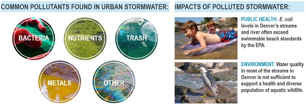
STORMWATER QUALITY MARION STREET GREEN INFRASTRUCTURE PROJECT COMMON SOURCES OF URBAN POLLUTANTS URBAN STORMWATER
 STORMWATER QUALITY COMMON SOURCES OF URBAN POLLUTANTS Fertilizers Litter Pet-waste COMMON POLLUTANTS FOUND IN URBAN STORMWATER BACTERIA TRASH METALS Dumpsters Vehicle exhaust, automotive fluids, etc. IMPACTS
DRAFT PLAN PRESENTATION
 DRAFT PLAN PRESENTATION 1.23.2018 AGENDA Process Project Schedule Results from Visioning Workshop Draft Plan Highlights Concept Plans Feedback Next Steps PROJECT SCHEDULE KICK-OFF WORKSHOP August 29 th
Blueprint Denver Task Force Meeting #
 Blueprint Denver Task Force Meeting #1 6.23.16 1. Welcome and Introductions Your name and affiliation Name 1 thing you love about Denver Name 1 thing you d change about Denver All in 30 seconds! Ready,
5.3 Central Platte Valley (CPV)
") 5.3 Central Platte Valley (CPV) Considered Denver s birthplace in 1858, the confluence of the South Platte River and Cherry Creek occurs in the Central Platte Valley at what is now called Confluence Park.
5.3 Central Platte Valley (CPV) Considered Denver s birthplace in 1858, the confluence of the South Platte River and Cherry Creek occurs in the Central Platte Valley at what is now called Confluence Park.
Town of Scarborough, Maine
 Town of Scarborough, Maine Planning Board June 2, 2014 1. Call to Order (7:00 P. M.) 2. Roll Call 3. Approval of Minutes (May 12, 2014) AGENDA 5. The Rock Church requests site plan review for expansion
Por favor, levanten la mano si necesita traduccion en espanol Please raise your hand if you need Spanish translation
 FEDERAL BOULEVARD CORRIDOR WIDE STUDY PUBLIC MEETING #1 APRIL 27, 2016 Por favor, levanten la mano si necesita traduccion en espanol Please raise your hand if you need Spanish translation HDR DESIGN WORKSHOP
Roosevelt Corridor. R e i n v e s t m e n t P l a n. Public Meeting Gilbert Elementary School May 12, :00 pm
 Roosevelt Corridor R e i n v e s t m e n t P l a n Public Meeting Gilbert Elementary School May 12, 2009 6:00 pm Agenda 6:00 6:10 6:25 6:40 6:55 7:00 Opening Comments Councilwoman Jennifer V. Ramos District
Citywide Integrated Stormwater Management Plan (ISMP) DRAFT ACTION PLAN REVIEW Public Consultation November 16 th, 2016
 DRAFT ACTION PLAN REVIEW Public Consultation November 16 th, 2016") Citywide Integrated Stormwater Management Plan (ISMP) DRAFT ACTION PLAN REVIEW Public Consultation November 16 th, 2016 1 Agenda DRAFT ACTION PLAN REVIEW Public Consultation Time 6:00 6:05 6:05 6:20 6:20
Citywide Integrated Stormwater Management Plan (ISMP) DRAFT ACTION PLAN REVIEW Public Consultation November 16 th, 2016 1 Agenda DRAFT ACTION PLAN REVIEW Public Consultation Time 6:00 6:05 6:05 6:20 6:20
6.5 Lakewood Gulch. Basin Snapshot
 6.5 Lakewood Gulch The Lakewood Gulch Map Unit is comprised of both Lakewood Gulch and Dry Gulch (4800-01 and 4801-01) from the Denver Storm Drainage Master Plan (SDMP) and has a total drainage area of
Portage Parkway Environmental Assessment Public Information Centre No. 1
 City of Vaughan Portage Parkway Environmental Assessment Public Information Centre No. 1 November 25, 2015 Welcome to the Public Information Centre This first Public Information Centre (PIC) introduces
Smart Growth for Dallas
 Smart Growth for Dallas Using data and GIS to improve the social, economic, and environmental resilience of Dallas Dallas Park and Recreation Board November 1, 2018 About Our Partners The Trust for Public
 701 E Ocean Blvd., Stuart, Florida 34994 100 Avenue A Suite 2A, Fort Pierce, Florida 34950 827 North Thornton Avenue, Orlando, Florida 32803 (772) 220-2100, Fax (772) 223-0220 (772) 467-1301, Fax (772)
Green Infrastructure Recommendations For Parks and Public Spaces
 Green Infrastructure Recommendations For Parks and Public Spaces Issued by the Jersey Water Works Green Infrastructure Committee And Prepared by Meliora Design This document recommends ways to integrate
Stakeholder Workshop #2
 Welcome! W3 th Realignment Study Stakeholder Workshop #2 We are pleased you are here to help advance the study, and we are eager to hear your ideas. How to get the most out of this workshop: Listen to
CITY OF CAMBRIDGE Growth & Intensification Study Secondary Plan Stakeholder Session September 12th, 2016
 CITY OF CAMBRIDGE Growth & Intensification Study Secondary Plan Stakeholder Session September 12th, 2016 Dillon Consulting Limited Watson & Associates Economists Curtis Planning Inc. Tim Welch Consulting
Green Infrastructure Mapping Exercise
 Green Infrastructure Mapping Exercise One Water Summit March 3, 2017 Mead Mier Sustainability Coordinator, Watershed Planning Lead Josh Pope GIS Manager Pima Association of Governments Outline What is
Does Green Infrastructure Pay? WASHOE COUNTY COMMISSION CHAMBERS RENO, NEVADA
 Does Green Infrastructure Pay? WASHOE COUNTY COMMISSION CHAMBERS RENO, NEVADA JANE KULIK, ASLA WENK ASSOCIATES, INC MARCH 30, 2006 the dollars and sense of green infrastructure: examining costs and benefits
Oroville Area Urban Greening Plan. Joint Meeting of the Oroville Planning, Park, and Arts Commissions October 12, 2015
 Oroville Area Urban Greening Plan Joint Meeting of the Oroville Planning, Park, and Arts Commissions October 12, 2015 Project Team Lead Agency Butte County Department of Development Services Claudia Stuart,
Metropolitan Area Planning Council 60 Temple Place, Boston, Massachusetts fax
 Metropolitan Area Planning Council 60 Temple Place, Boston, Massachusetts 02111 617-451-2770 fax 614-482-7185 www.mapc.org Serving the 101 Cities and Towns in the Metropolitan Boston Region MEMORANDUM
John Callaway, for Rees 514 LLC & Brent Brunswick LLC Name of Project
 COMMUNITY DEVELOPMENT DEPARTMENT Planning and Zoning Division 1725 Reynolds Street, Suite 200, Brunswick, GA 31520 Phone: 912-554-7428/Fax: 1-888-252-3726 PLANNING COMMISSION STAFF REPORT DATE November
Agenda Item # 1. Meeting Date September 21, Prepared By. Approved By
 Agenda Item # 1 Work Session Meeting Date September 21, 2015 Prepared By Approved By Erkin Ozberk, Senior Planner Suzanne R. Ludlow City Manager Discussion Item Background Discussion of Site Plan Application
Town of Chapel Hill. Prepared By: A Division of Pennoni. Chapel Hill, NC (919) Firm License: F-1267.
 Firm License: F-1267.") 401 Providence Road Suite 200 Chapel Hill, NC 27514 T: 919-929-1173 F: 919-493-6548 Firm License #: F-1267 www.pennoni.com Town of Chapel Hill Orange County, North Carolina STATEMENT OF COMPLIANCE Prepared
401 Providence Road Suite 200 Chapel Hill, NC 27514 T: 919-929-1173 F: 919-493-6548 Firm License #: F-1267 www.pennoni.com Town of Chapel Hill Orange County, North Carolina STATEMENT OF COMPLIANCE Prepared
Integrating LEED ND & SITES Into Your Design Approach
 Integrating LEED ND & SITES Into Your Design Approach Joshua C. Sloan, RLA, ASLA, AICP, LEED AP ND, SITES AP Stephen K. Cook, RLA, ASLA, LEED AP O+M VIKA MD, LLC Planning Landscape Architecture Engineering
INDEPENDENCE BOULEVARD AREA PLAN. June 24, 2008
 INDEPENDENCE BOULEVARD AREA PLAN Public Meeting #1 June 24, 2008 Tonight s Agenda Introduction Welcome and Ground Rules Overview Presentation Purpose of the Plan What Brings Us Here? A Tour of the Corridor
COUNCIL COMMUNICATION
 Meeting Date: June 13, 2017 COUNCIL COMMUNICATION Agenda Item: Agenda Location: Consent Calendar Work Plan # 194,195, 196 Legal Review: 1 st Reading 2 nd Reading Subject: A resolution approving Thornton
Metro 2010 Pedestrian Symposium Walking into the Future City
 Metro 2010 Pedestrian Symposium Walking into the Future City John Kaliski, AIA, May 12, 2010 How can our transportation and land use policies create complete streets for all users? How do we optimize the
Case Study: City of San Mateo
 Published on GreenPlan-IT (http://greenplanit.sfei.org) Home > Archived Materials > GreenPlan-IT Toolkit Demonstration Report > Chapter 2. Case Study: City of San Mateo Case Study: City of San Mateo Chapter
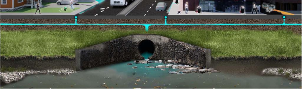
Water in storm drains does not go to a treatment plant
 Watershed Planning Workshop Upper Mainstem & Middle Four Mile Run November 30, 2011 Fairlington Community Center Arlington s watersheds Chesapeake Bay watershed Watershed Planning Initiated May 2008 Contracted
STORMWATER UTILITY FREQUENTLY ASKED QUESTIONS
 STORMWATER UTILITY FREQUENTLY ASKED QUESTIONS What is Stormwater? Stormwater is water that falls to the ground during a precipitation event. When land is undeveloped or covered with vegetative surface,
GRACE CHURCH EXPANSION
 GRACE CHURCH EXPANSION REVIEW: NOVEMBER 24, 2014 200 SAGE ROAD, CHAPEL HILL NORTH CAROLINA PROJECT DATA OVERALL SITE MAP SITE INFORMATION OWNER PIN ACREAGE VICINITY MAP GRACE CHURCH 9890503171 271,600
KENDALL SQUARE INITIATIVE. Planned Unit Development Special Permit Application - SoMa September 8, 2015
 KENDALL SQUARE INITIATIVE Planned Unit Development Special Permit Application - SoMa September 8, 2015 GENERAL DEVELOPMENT GOALS Kendall Square PUD 2 PRE-ZONING PUBLIC ENGAGEMENT 2008-2009 2010-2012 2013
TOWN OF BETHLEHEM OPEN SPACE CONSERVATION PLAN PUBLIC MEETING: OCTOBER 12, 2017
 TOWN OF BETHLEHEM OPEN SPACE CONSERVATION PLAN PUBLIC MEETING: OCTOBER 12, 2017 Welcome and Agenda 6:00 6:45: Open House, Part One 6:45 7:15: Presentation and Questions 7:15 8:00: Open House, Part Two
Presentation Item C Annotated Model Outline for a Framework for a Green Infrastructure Plan
 Date: August 17, 2016 To: From: Subject: Management Committee Dan Cloak, Consultant Presentation Item C Annotated Model Outline for a Framework for a Green Infrastructure Plan Recommendation: Receive the
CIP Project Descriptions
 City and County of Denver Department of Public Works Wastewater Capital Projects Management 2016-2021 CIP Project Descriptions Page 1 Revised : 2016-06-21 Council Districts Citywide Citywide Citywide Citywide
MORRISVILLE TRANSPORTATION PLAN TOWN COUNCIL PRESENTATION AUGUST 22, 2017
 TOWN COUNCIL PRESENTATION AUGUST 22, 2017 SCENARIO PLANNING CORRIDORS Town Hall Drive Baseline + 2 McCrimmon Parkway Baseline + 2 NC 54 Baseline + 2 7 subregion model runs determining carrying capacity
The Residences at Alewife Station
 The Residences at Alewife Station 195 & 211 Concord Turnpike Community Meeting Peabody School November 10, 2016 Site Context Special District 4 Special District 4 Restored Planned Development Special District
DENVER DESIGN DISTRICT GDP
 DENVER DESIGN DISTRICT GDP Urban Design Standards and Guidelines November 17, 2008 Amended February 3, 2016 City and County of Denver CF Property Management, Inc. C/O Denver Design District - Starboard
5.6 Valverde. Basin Snapshot. Valverde Land Uses
 5.6 Valverde The Valverde water quality map unit is located in west Denver and generally overlaps with Basin 0064-02 (Valverde) in the City and County of Denver Storm Drain Master Plan (SDMP). The basin
Rhode Island Stormwater Design and Installation Standards Manual
 Rhode Island Stormwater Design and Installation Standards Manual RIDOT Workshop LID Site Planning and Design Strategies: How to Meet Minimum Standard No. 1 August 25, 2011 Low Impact Development (LID)
STORMWATER REPORT FOR WALMART SUPERCENTER STORE # SIOUX FALLS, LINCOLN COUNTY, SOUTH DAKOTA BFA PROJECT NO
 STORMWATER REPORT FOR WALMART SUPERCENTER STORE # 2443-00 SIOUX FALLS, LINCOLN COUNTY, SOUTH DAKOTA BFA PROJECT NO. 3286 March 1, 2012 I hereby certify that this engineering document was prepared by me
LID/GI and BMP Case Studies
 LID/GI and BMP Case Studies Metro Atlanta Goal Reduction of runoff volume and pollutant load Aesthetic improvement/revitalization Opportunistic project implementation Policy, funding, and planning Partnering
Jenifer Street Reconstruction Neighborhood Engagement Meeting November 4, 2015
 Jenifer Street Reconstruction Neighborhood Engagement Meeting November 4, 2015 Hosted by the Marquette Neighborhood Association Facilitated by Urban Assets Funded in part by the City of Madison Neighborhood
Street Flooding Mitigation Plan KYOVA Interstate Planning Commission. Presented to AMPO National Conference October 18, 2017
 Street Flooding Mitigation Plan KYOVA Interstate Planning Commission Presented to AMPO National Conference October 18, 2017 Saleem Salameh, Ph.D., P.E., M.ASCE Chet Parsons, AICP CTP Agenda: Background
MONTGOMERY COUNTY PLANNING DEPARTMENT THE MARYLAND-NATIONAL CAPITAL PARK AND PLANNING COMMISSION
 MONTGOMERY COUNTY PLANNING DEPARTMENT THE MARYLAND-NATIONAL CAPITAL PARK AND PLANNING COMMISSION William H. Farquhar Middle School Modernization MCPB Item No. 10 Date: 09-18-2014 Description Summary Fred
TAC/CAC, TPO Project Update February 2016
 A1A MULTIMODAL CORRIDOR PLANNING AND ENGINEERING ANALYSIS Florida Department of Transportation TAC/CAC, TPO Update February 2016 PRESENTATION FOOTERT Meeting Agenda What We Plan To Discuss Background New
FLEET AVENUE GREEN STREET USES VACANT LOT FOR CSO REDUCTION. Thomas M. Evans, AECOM Cleveland, Ohio
 FLEET AVENUE GREEN STREET USES VACANT LOT FOR CSO REDUCTION Thomas M. Evans, AECOM Cleveland, Ohio INTRODUCTION As part of the Northeast Ohio Regional Sewer District s (Sewer District) Green Infrastructure
SAWYER RANCH ROAD Pedestrian and Bicycle Improvements
 SAWYER RANCH ROAD Pedestrian and Bicycle Improvements RM 150: From West of Kyle to I-35 Oct. 25, 2018 Thank you for your interest in the RM 150 project. The purpose of this meeting is to share project
Berkeley Strategic Transportation Plan
 Berkeley Strategic Transportation Plan 48 4. Priming the Pipeline 4. Priming the Project Pipeline Building on our history Using past studies that required the effort and input of all of Berkeley s distinct
Countywide Green Infrastructure
 Montgomery County s Countywide Green Infrastructure F U N C T I O N A L M A S T E R P L A N The Maryland National Capital Park and Planning Commission INFRASTRUCTURE An underlying base or foundation especially
This is the East Carolina University Comprehensive Facilities Master Plan Final Draft Plan Review. This workbook reviews the campus draft master plan
 This is the East Carolina University Comprehensive Facilities Master Plan Final Draft Plan Review. This workbook reviews the campus draft master plan first presented on campus on June 29 and June 30, 2011.
LID Permit Requirements. Lisa Austin. Geosyntec Consultants
 LID Permit Requirements Lisa Austin Geosyntec Consultants Presentation Outline Types of LID Permit Requirements Specified site design Specified LID BMPs LID performance metrics Specified Site Design (San
Chesapeake Bay Critical Area Conservation Plan
 The Maryland-National Capital Park and Planning Commission Prince George s County Planning Department Development Review Division 301-952-3530 Note: Staff reports can be accessed at www.mncppc.org/pgco/planning/plan.htm.
Mitchell Ranch South MPUD Application for Master Planned Unit Development Approval Project Narrative. Introduction
 Mitchell Ranch South MPUD Application for Master Planned Unit Development Approval Project Narrative Introduction Mitchell Ranch South is a proposed single family (detached) residential development on
Chapter 2: Strategies for Local Governments Chapter 3: Site Assessment and Design for Low Impact Development. Break Out Group 10:30 am to 12 pm
 Chapter 2: Strategies for Local Governments Chapter 3: Site Assessment and Design for Low Impact Development Break Out Group 10:30 am to 12 pm A Low Impact Development Manual for Coastal South Carolina
A Claustrophobic Corridor Grows Up
 A Claustrophobic Corridor Grows Up Presenters: Chris Bauserman, PE, PS Delaware County Engineer Jeff Griffin, PE Burgess & Niple, Inc. Brian Moore, PE Burgess & Niple, Inc. PROJECT OVERVIEW Sawmill Parkway
St. Clair Avenue West Area Transportation Master Plan
 1 (Between Keele Street and Old Weston Road) Public Information Centre 1 December 2, 2015 2 Welcome Welcome to the first Public Information Centre for the St. Clair Avenue West Area. The panels will present
Third Ave CSO Integrated Green Infrastructure
 Third Ave CSO Integrated Green Infrastructure Neil Myers Williams Creek Consulting OWEA Annual Conference June 2013 For growing municipalities to be perceived as world class communities, each must move
Oroville Area Urban Greening Plan. Second Communitywide Workshop
 Oroville Area Urban Greening Plan Second Communitywide Workshop Monday, November 18, 2013 PROJECT TEAM Lead Agency Butte County Department of Development Services Claudia Stuart, Principal Planner Chris
Conceptual Review Agenda
 Conceptual Review Agenda Schedule for 02/27/17 to 02/27/17 281 Conference Room A Monday, February 27, 2017 Time Project Name Applicant Info Project Description Planner 9:30 419 Wood Street Multi-Family
Working Group Meeting
 April 4,, 2017 Parks Operations Bldg Working Group Meeting Arts Districts Overview Stormwater/RPA/Stream Considerations First Principles Agenda 7:00pm 7:05pm 7:10pm 7:40pm 8:30pm 9:40pm 9:45pm Welcome
CITY OF VALPARAISO STORMWATER MASTER PLAN
 CITY OF VALPARAISO STORMWATER MASTER PLAN APPROVED BY THE VALPARAISO CITY UTILITIES BOARD OCTOBER, 2016 Prepared by the City of Valparaiso Engineering Department PLAN SUMMARY Major flash flooding in August
REPORT TO PLANNING AND DESIGN COMMISSION City of Sacramento
 REPORT TO PLANNING AND DESIGN COMMISSION City of Sacramento 5 PUBLIC HEARING June 12, 2014 To: Members of the Planning and Design Commission Subject: Newman Center Sign (P14-017) A request to construct
The following principles guide the development of goals and strategies to protect and promote these amenities:
 OPEN SPACE/PARKS/TRAILS/RECREATION GOALS/STRATEGIES Cherry Hills Village is a living environment that offers low density development, open areas, public scenic vistas, public trails and public parks. This
St. Laurent Transit Improvements Innes / Industrial to Smyth. Public Information Session December 2, 2015
 St. Laurent Transit Improvements Innes / Industrial to Smyth Public Information Session December 2, 2015 Agenda Introduction Project Background Preliminary Design Widening for transit lanes Roadway resurfacing
Presenting a Vision for Thread Lake
 Presenting a Vision for Thread Lake FEBRUARY 20, 2014 SPECIAL THANKS TO: International Academy of Flint Flint River Watershed Coalition South Saginaw Business and Resident Association South Side Neighborhood
Concreteville, CT. March 10, 2004
 Concreteville, CT March 10, 2004 Reducing Runoff is the most topically direct follow up to Linking Land Use to Water Quality (Basic NEMO). There is a good deal of overlap, but the major differences is