INTEGRATION PLAN. Harvard Gulch
|
|
|
- Dwight Jack Chambers
- 5 years ago
- Views:
Transcription

1 INTEGRATION PLAN Harvard Gulch August 31, 2016


2 Related Projects and Partners
3 Tonight s Agenda 1. Welcome & Meeting Purpose 2. Other Project Updates Floodplain Study Urban Waterways Study 3. Purpose of the Integration Plan 4. Integration Plan Ideas 5. Gather Feedback/Open House
4 Federal Blvd Colorado Blvd Harvard Ave For discussion purposes only Study Area Harvard Gulch Iliff Ave Broadway University Blvd

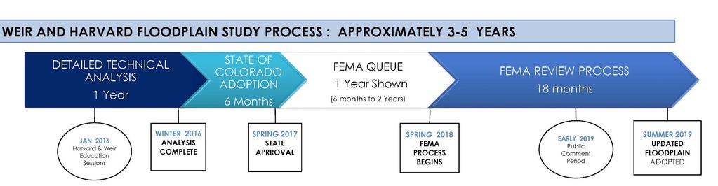
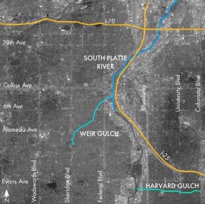
5 Related Projects Floodplain Study
6 Related Projects Denver Urban Waterways Study Study Update: Project team is evaluating the range of options Recommend a preferred option based on selection criteria Release report of proposed preferred plan and review at public meeting Late 2016 / Early 2017 Army Corps & City of Denver selection of plan Mid

7 Integration Plan What is the purpose? Build upon and complement the technical Army Corps study by envisioning neighborhood place-making benefits and connections Identify neighborhood enhancements that will better connect and activate your community
8 Integration Plan How will it be used? Used to inform potential enhancements to Army Corps work Used to prioritize future complementary City investments within your neighborhood The neighborhood enhancements have the potential of happening regardless of the timing of the Army Corps study Why now? We want your input on the greater vision early in the process
9 Other Denver Projects in the Area Harvard Gulch Harvard Gulch and Dry Gulch Tributary Floodplain Study Overland Neighborhood Plan Evans Station Area Plan South Broadway Corridor Study University Park Neighborhood Plan

10 Public Input to Date From Urban Waterways Study Desire for quality parks, urban gardens and open channel within the neighborhood Maintenance of the parks and open spaces Desire for comfortable connections to Harvard Gulch Concern about property impacts

11 Harvard Gulch Existing Conditions Broadway Evans Ave University Blvd Colorado Blvd Yale Ave For discussion purposes only
12 Goals of Integration Plan Harvard Gulch Establish clear connections from Gulch to neighborhood Establish clear visual and physical linkages between trail segments All trail/road crossings should have clear striping and should be signalized or grade separated Gulches should be amenity spaces

13 Integration Plan Terms Harvard Gulch Bike/Ped: bicycle and pedestrian Grade-separated: pedestrian/bike underpass or bridge Enhanced Crossings: comfortable street crossing for pedestrian/bikes that have striping and possibly a pedestrian signal Shared Street: Street where cars, bikes and pedestrians all share the same space making cars go slower Green Street: Street that is multi-modal and incorporates water quality into the streetscape design


14 Harvard Gulch Overall Plan Iliff Ave Harvard Ave Broadway University Blvd Colorado Blvd For discussion purposes only


15 Harvard Gulch - Reach 1 Ideas Iliff Ave Delaware St Bannock St Wesley Ave Broadway Sherman St Harvard Ave 1. Convert Wesley Ave into a green street with a trail connection to the South Platte River and traffic signal at Wesley and Broadway. 2. Minimize impact to Denver Urban Garden s Rosedale Gardens. For discussion purposes only


16 Harvard Gulch Reach 1 Ideas Wesley Ave. Green Street Concept For discussion purposes only


17 Harvard Gulch Reach 2 & 3 Ideas Iliff Ave Sherman St Harvard Ave Logan St Pearl St Emerson St Ogden St Downing St 1. Realign open channel along southern edge of park. 2. Between Ogden and Downing, realign channel with Harvard Ave creating a shared/green street. Coordinate improvements with Porter Hospital. For discussion purposes only

18 Harvard Gulch Reach 3 Ideas Shared/Green Street Concept at Porter Hospital For discussion purposes only


19 Harvard Gulch Reach 4 Ideas Wesley Ave Downing St Marion St Lafayette St Humboldt St Franklin St Gilpin St Williams St High St Race St Harvard Ave 1. Provide street crossings at Lafayette, Franklin and High St. Further study traffic patterns to confirm proposed crossing locations. 2. Align the channel to take advantage of existing, city-owned properties and minimize property impacts. For discussion purposes only


20 Harvard Gulch Reach 5 Ideas Harvard Ave Josephine St Race St Vine St Gaylord St York St University St Columbine St Clayton St Vassar Ave 1. Study feasibility of providing a pedestrian underpass at University. If not feasible, then study best way to provide signalized crossing. 2. Remove street crossings at Race, York and Columbine but allow Josephine St to cross Gulch. 3. Provide ped/bike only crossing at York and Gaylord. For discussion purposes only

21 Harvard Gulch Reach 6 Ideas Clayton St Harvard Ave Fillmore St Milwaukee St St Paul St Steele St Adams St Cook St Madison St Monroe St Garfield St Jackson St Colorado Blvd Harvard Ave 1. Work with YMCA and other property owners to extend trail connection to Colorado Blvd at the signal. 2. Preserve Adams and Vassar intersection by providing a culvert. For discussion purposes only
22 Feedback & Open House We want to hear your likes, dislikes and top priorities. Visit the stations tonight, write comments on the plans and place dots next to your top priorities Comment online at
23 Next Steps & Schedule Urban Waterways Study Public Meeting #3 Winter 2016/2017 Propose preferred plan at public meeting
24 Q & A
25 Contact Information To contact the project team, please Call 311 and reference Denver Waterways Tiffany Vanosdall Army Corps Study PM Selena Klosowski / Karen Good Denver Study PM Jeremy Hamer Denver Floodplain Manager
2017 General Obligation Bond
 2017 General Obligation Bond Presentation of Public and Council Projects to the Transportation & Mobility Stakeholder Committee April 13, 2017 Agenda Deferred Maintenance Project Development Process Projects
Por favor, levanten la mano si necesita traduccion en espanol Please raise your hand if you need Spanish translation
 FEDERAL BOULEVARD CORRIDOR WIDE STUDY PUBLIC MEETING #1 APRIL 27, 2016 Por favor, levanten la mano si necesita traduccion en espanol Please raise your hand if you need Spanish translation HDR DESIGN WORKSHOP
South Federal corridor improvements
 South Federal corridor improvements Welcome to the South Federal Green Infrastructure Project Public Open House October 25, 2018 The City and County of Denver Department of Public Works, in collaboration
CONTEXT: the Highway, the River + the Railroads run through us.
 CONTEXT: the Highway, the River + the Railroads run through us. I-25 36 In the past they have divided us, now we have an opportunity to unite us. I-76 I-270 I-76 CSU I-25 LEGEND Cut + Cover River North
Stakeholder Workshop #2
 Welcome! W3 th Realignment Study Stakeholder Workshop #2 We are pleased you are here to help advance the study, and we are eager to hear your ideas. How to get the most out of this workshop: Listen to
EXISTING CONDITIONS AND PROJECTIONS
 RIVER NORTH PLAN EXISTING CONDITIONS AND PROJECTIONS BRIGHTON BOULEVARD/40 TH AND 40 TH TOD 29 EXISTING CONDITIONS AND PROJECTIONS Z ONING The location of a rezoning from industrial to R-MU-30 along Brighton
Future Proposed Development
 Future Proposed Development on and around Link light rail s Capitol Hill Station Meeting September 24, 2012 Tonight s Agenda 6:00 pm Open House 6:30 pm Introductions Richard Conlin, City of Seattle Councilmember/Sound
Secrest Short Cut and Monroe Expressway Small Area Plan AUGUST 29, 2018
 Secrest Short Cut and Monroe Expressway Small Area Plan AUGUST 29, 2018 Background and Process Monroe Expressway will be open by the end of 2018 Union County and Indian Trail identified a need to revisit
Workshop #3 June 13, 2016
 Downtown Ocoee Master Plan Workshop #3 June 13, 2016 Our Team Our Team and Tonight s Goal Quick Recap: Why a Downtown Plan? How are we developing the plan? How can you still be involved? What s left to
Corridor Vision. 1Pursue Minnehaha-Hiawatha Community Works Project. Mission of Hennepin County Community Works Program
 1Pursue Minnehaha-Hiawatha Community Works Project Minnehaha-Hiawatha Community Works is a project within the Hennepin Community Works (HCW) program. The mission of the HCW program is to enhance how the
TO: Denver Planning Board FROM: Chandler Van Schaack, Senior City Planner DATE: March 27, 2019 RE:
 Community Planning and Development Planning Services W. Colfax Ave., Dept. Denver, CO 0 p:.. f:..0 www.denvergov.org/cpd TO: Denver Planning Board FROM: Chandler Van Schaack, Senior City Planner DATE:
Old Town Neighborhoods Plan. Choices Event Wednesday, December 9, 2015
 Old Town Neighborhoods Plan Choices Event Wednesday, December 9, 2015 Agenda 6:00 6:10 p.m. Welcome + Sign In 6:10 6:30 p.m. Presentation 6:30 8:00 p.m. Workshop + Open House Seeking your input on: Neighborhood
NORTH CLAYMONT AREA MASTER PLAN COMMUNITY WORKSHOP #1 FEBRUARY 3, 2016
 NORTH CLAYMONT AREA MASTER PLAN COMMUNITY WORKSHOP #1 FEBRUARY 3, 2016 1. Introduction To the team and to the Plan Planning Partners The Claymont Community WILMAPCO New Castle County Claymont Renaissance
Urban runoff in my neighborhood (Capitol Hill) is heavy with trash and other debris.
 is heavy with trash and other debris.") South Platte River Meeting Comments & s #1 I am a huge fan of river areas and would love the Platte and surrounding waterways to improve to allow habitat for wildlife and recreation opportunities for citizens.
South Platte River Meeting Comments & s #1 I am a huge fan of river areas and would love the Platte and surrounding waterways to improve to allow habitat for wildlife and recreation opportunities for citizens.
LOWELL & EVANS. Public Meeting #1. Green Infrastructure Water Quality Community Space. August 17th, 2017
 Public Meeting #1 August 17th, 2017 Welcome! Councilman Kevin Flynn, District 2 City and County of Denver, Public Works; Water Quality. Sarah Anderson WQ Program Manager Brian Wethington WQ Project Manager
Design Guideline Themes: Course and Community Facilities
 Design Course and Community Facilities Design Community Connectivity Connections Significant pedestrian traffic currently exists through and around the course perimeter Pedestrian connections should not
RIVER ARTS DISTRICT TRANSPORTATION PROJECT
 RIVER ARTS DISTRICT TRANSPORTATION PROJECT A section of the Public Meeting #3 December 6, 2012 The RiverWay Plan The Wilma Dykeman RiverWay is a 17 mile corridor along the French Broad and Swannanoa Rivers.
Blueprint Denver Task Force Meeting #
 Blueprint Denver Task Force Meeting #1 6.23.16 1. Welcome and Introductions Your name and affiliation Name 1 thing you love about Denver Name 1 thing you d change about Denver All in 30 seconds! Ready,
6.3 Elyria-Swansea. Basin Snapshot
 6.3 Elyria-Swansea The Elyria-Swansea Map Unit is comprised of the I-70 & Colorado Blvd basin (0060-01) and the I-70 & York basin (0060-02) from the Denver Storm Drainage Master Plan (SDMP) and has a total
Atlanta BeltLine. Subareas 9 & 10. Master Plan Updates. March 26, Washington Park Jamboree 1
 Atlanta BeltLine Subareas 9 & 10 Master Plan Updates March 26, 2018 Washington Park Jamboree 1 22 miles, connecting 45 neighborhoods 22 MILES of transit 46 MILES of streetscapes and complete streets 33
Welcome. Northern Segment of Hwy 100 I-90 to South of Madison Street Meeting Goals:
 Welcome Northern Segment of Hwy 100 I-90 to South of Madison Street Meeting Goals: - Review Environmental Assessment - Share Preferred Alternative -Receive Public Comments 2003 EA Preferred Alternative
CITY OF THORNTON LICENSED CONTRACTORS
 CITY OF THORNTON LICENSED CONTRACTORS Current as of: 4/2/2018 Name Street Address CSZ Phone Licensee No. License Type 321 DESIGN AND BUILD 12036 Grape St Thornton, CO 80241 303-949-9442 LCC201700235 Class
CIP Project Descriptions
 City and County of Denver Department of Public Works Wastewater Capital Projects Management 2016-2021 CIP Project Descriptions Page 1 Revised : 2016-06-21 Council Districts Citywide Citywide Citywide Citywide
Potential Green Infrastructure Strategies May 6, 2015 Workshop
 Potential Green Infrastructure Strategies May 6, 2015 Workshop Background The City of Cortland is developing the Tioughnioga Urban Headwaters Green Infrastructure Action Plan with funding from the National
City of Meriden Harbor Brook Flood Control Project Overview
 City of Meriden Harbor Brook Flood Control Project Overview Updated August 2013 OVERVIEW The center of Meriden, including the HUB site is the low point of the town which is ringed by basalt ridges. Running
Small Area Plan. South Gateway
 Small Area Plan Adopted May 12, 2008 South Gateway Purpose. The South Gateway Small Area Plan defines the City s expectations for the future of the southern entrance to the City at Interstate 85 and Highway
Clovis Urban Greening Plan. Community Workshop #2 Northwest
 Clovis Urban Greening Plan Community Workshop #2 Northwest Thursday, October 9, 2014 WHAT IS AN URBAN GREENING PLAN? A guide to help the City to improve quality of life for residents Identification of
City of Plattsburgh DRI: Downtown Streetscapes & Riverfront Access. Downtown Streetscape and Riverfront Access Design
 City of Plattsburgh DRI: Downtown Streetscapes & Riverfront Access Welcome Thank you for coming this evening. Agenda PART I - Project Context The Downtown Revitalization Program Our DRI Projects Other
Introduction. Chapter 1. Purpose of the Comprehensive Plan Plan Organization Planning Process & Community Input 1-1
 Chapter 1 Introduction Lakewood 2025: Moving Forward Together Purpose of the Comprehensive Plan Plan Organization Planning Process & Community Input 1-1 Purpose of the Comprehensive Plan The Comprehensive
Pedestrian and Bike Bridge LOGO
 6.2.2 Pedestrian and Bike Bridge The proposed pedestrian and bike crossing re-envisions the existing bridge at Pismo Creek on Cypress Street. The bridge is currently underutilized by vehicular through
East Corridor Final Environmental Impact Statement
 East Corridor Final Environmental Impact Statement Alternatives Considered Operating Plan The requirements for opening day operations versus year 2030 are based on ridership and operations. Opening day
Expo Light Rail Line. Expo Line Community Meeting Phase 2 Design Update November 2011
 Expo Line Community Meeting Phase 2 Design Update November 2011 Meeting Agenda Phase 2 Design Update Meeting Meeting Purpose and Format Project Status Update Overview of Design Progress Next Steps Open
Welcome to the Public Meeting!
 Welcome to the Public Meeting! Please sign in, grab a paper survey, and check out the boards around the perimeter of the room. Once you ve viewed all of the boards, come join us in the middle of the room
ROBBINSDALE LRT STATION CDI DEVELOPMENT GUIDELINES
 August 2018 OVERVIEW The City of Robbinsdale has a prime-opportunity site in the middle of the 13 mile stretch of the Bottineau LRT corridor / Blue Line extension. Robbinsdale offers a prominent, vital,
Complete Streets in Lancaster County
 Complete Streets in Lancaster County PRESENTED BY: Robert Bini, AICP Director for Transportation Planning November 14, 2017 Lancaster County is a growing county of over 534,000 and the bottom line is...
Subarea 4 Indian Creek. Vision The combination of park networks and transportation amenities make Subarea 4 the greenest hub in the Corridor.
 indian creek 180 extends south from 101st Street to I-435. The I-435 and Metcalf intersection is one of the primary intersections in the Kansas City Metro Area. The area includes several residential neighborhoods
Welcome. Green Line LRT. Beltline Alignment Options. Stay engaged! Follow the Green Line story at calgary.ca/greenline
 Welcome Green Line LRT Beltline Alignment Options Stay engaged! Follow the Green Line story at calgary.ca/greenline Green Line LRT Why are we here? Our Challenge Determine the best alignment in the Beltline.
Long Branch-Wayne Local Park Renovation Project
 Montgomery Parks Long Branch-Wayne Local Park Renovation Project Community Meeting #2 September 20, 2016 Oak View Elementary School 7:00-9:00 PM Welcome / Team Introductions M-NCPPC (Montgomery Parks)
Illustration of Eastlake Farmer s Cooperative Grain Elevator. Chapter 5: implementation 5-1
 Illustration of Eastlake Farmer s Cooperative Grain Elevator Chapter 5: implementation 5-1 chapter 5: implementation Introduction The Eastlake Subarea Plan includes a wide range of recommendations intended
Beaverton City Council: Work Session. SIDEDistrict. May 6, 2014
 BEAVERTON Beaverton City Council: CREEK Work Session SIDEDistrict May 6, 2014 Tonight s Agenda BEAVERTON CREEK SIDE Brief updates Creekside Vision Scenarios & discussion: Redevelopment & Parking Project
DENVER DESIGN DISTRICT GDP
 DENVER DESIGN DISTRICT GDP Urban Design Standards and Guidelines November 17, 2008 Amended February 3, 2016 City and County of Denver CF Property Management, Inc. C/O Denver Design District - Starboard
2035 General Plan Update and Belmont Village Specific Plan. Joint Study Session with the City Council and Planning Commission April 12, 2016
 2035 General Plan Update and Belmont Village Specific Plan Joint Study with the City Council and Planning Commission April 12, 2016 Agenda 1. Welcome and Introductions 2. General Plan Update Status of
South Davis County COMMUNITY SPOTLIGHT
 South Davis County COMMUNITY SPOTLIGHT Davis/SLC Community Connector Bus Rapid Transit line connecting SLC & Davis County RTP Phase 1 Project Generate 3,100 average weekday riders Relieve congestion on
The University District envisions, in its neighborhood
 Envisioning the University District Link Light Rail in Seattle s neighborhoods CIY OF SEALE CONCEP-LEVEL SAION AREA PLANNING RECOMMENDAION RESOLUION # 30165 EXHIBI L Vision 08.2000 he University District
Enhance the High Line Canal Projects
 Enhance the High Line Canal Projects Joint Project Proposal for Arapahoe County Open Spaces Funding Partner Sponsors: South Suburban Park and Recreation District City of Centennial City of Littleton October
Planning for TOD Implementation at a Corridor Scale
 Planning for TOD Implementation at a Corridor Scale Catherine Cox Blair, Reconnecting America Presentation to DRCOG and the Sustainable Communities Initiative May 14, 2012 What is Reconnecting America?
Corridor Enhancements
 Corridor Enhancements Safety is MoDOT s first priority in widening and rebuilding I-70 across the state of Missouri. MoDOT also understands that the interstate - and its interchanges and overpasses - are
Planning for TOD Implementation at a Corridor Scale
 Planning for TOD Implementation at a Corridor Scale Bill Sadler, Reconnecting America Presentation to Gold Line Corridor Working Group July 2, 2013 What is Reconnecting America? Reconnecting America is
THEMES, VISION, + PRINCIPLES
 CHAPTER 2: THEMES, VISION, + PRINCIPLES This page intentionally left blank. 20 VISION DRAFT AUGUST 2018 2 2 THEMES, VISION, + GUIDING PRINCIPLES The Key Themes, Vision, and Guiding Principles presented
UCSF Parnassus Heights Re-Envisioning Process
 UCSF Parnassus Heights Re-Envisioning Process Community Working Group Meeting #5 February 27, 2019 Agenda Welcome, Introductions, Agenda Overview, and Review of Last Meeting Summary of Community Ideas
Public Open House. Welcome! Presentation at 5:15 p.m. Please sign-in at the registration table
 Public Open House Welcome! Presentation at 5:15 p.m. Please sign-in at the registration table The Grand Avenue Extension Location and Environmental Study will determine the location of the extension of
March 1, PWG Meeting #4
 March 1, 2013 PWG Meeting #4 1 Meeting Agenda 2 History & Overview Circle Interchange was built in the late 1950 s and early 1960 s, and the facility is in need of major repair or reconstruction. 3 History
The Illinois Department of Transportation and Lake County Division of Transportation. Route 173, including the Millburn Bypass
 The Illinois Department of Transportation and Lake County Division of Transportation welcome you to this Public Hearing for U.S. Route 45 from Illinois Route 132 to Illinois Route 173, including the Millburn
A G E N D A Council Update Training Room September 26, :45 p.m.
 CITY OF THORNTON CITY MANAGER S OFFICE A G E N D A Council Update Training Room September 26, 2017 5:45 p.m. A. Boards and Committees Reports (Estimated 20 Minutes) 1. Rangeview Library District Meeting
Rich Valley Greenway Master Plan. Central Greenway Connectivity Study
 Rich Valley Greenway Master Plan Central Greenway Connectivity Study Dakota County Planning Commission February, 2017 Rich Valley Greenway Master Plan Dakota County Greenway Vision Establish a County-wide
Gold Line Bus Rapid Transit Transit Oriented Development (BRTOD) Helmo Station Area Plan
 Helmo Station Area Plan") Appendix F Gold Line Bus Rapid Transit Transit Oriented Development (BRTOD) Helmo Station Area Plan Introduction and Purpose of the Plan The Gold Line Bus Rapid Transit facility is an eleven-mile dedicated
Appendix F Gold Line Bus Rapid Transit Transit Oriented Development (BRTOD) Helmo Station Area Plan Introduction and Purpose of the Plan The Gold Line Bus Rapid Transit facility is an eleven-mile dedicated
WORKSHOP PURPOSE PERRY COMPREHENSIVE PLAN COMMUNITY WORKSHOP APRIL 4 TH, 2013 WHAT IS A COMPREHENSIVE PLAN? AGENDA
 WORKSHOP PURPOSE PERRY COMPREHENSIVE PLAN COMMUNITY WORKSHOP APRIL 4 TH, 2013 Provide background information on the Perry Comprehensive Plan Tap the expertise of the local experts (YOU!) Understand what
BROOKLYN PARK / 85TH AVE LRT STATION CDI DEVELOPMENT GUIDELINES DRAFT
 August 2018 Page intentionally left blank The Brooklyn Park Library adjacent to the 85th Ave LRT Station Area. OVERVIEW The Blue Line LRT Extension / Bottineau corridor offers a unique opportunity to leverage
Strachan Ave. Overpass Community Design Update. October 26, 2010 Stephen Lipkus Executive Director Georgetown South Project GO Transit
 Strachan Ave. Overpass Community Design Update October 26, 2010 Stephen Lipkus Executive Director Georgetown South Project GO Transit Welcome Program Overview 6:30 8:30 p.m.: Storyboard Review Project
WELCOME 4201 E. ARKANSAS AVENUE PROPERTY COMMUNITY DISCUSSION
 WELCOME 4201 E. ARKANSAS AVENUE PROPERTY COMMUNITY DISCUSSION Salem United Church of Christ June 7, 2018 AGENDA Introduction Existing Conditions CDOT s Next Steps Proposed Zoning Overview Transportation
Tonight s Agenda. Summary Presentation Open House. Group Discussion Next Steps: online community wide survey
 Community Open House February 22, 2018 Tonight s Agenda Summary Presentation Open House Station 1: Project Overview and Community Input Station 2: Draft Vision and Guiding Principles Station 3: Western,
Meeting Agenda. 1. Introductions (5 min)
") Meeting Agenda Monaca, PA Ohio River Brownfields Redevelopment Planning Federal/State/Regional Partners Meeting June 5, 2012; 3-4pm EDT Conference call-in #: 1-866-299-3188 Conference code: 202 566 0633#
Meeting Agenda Monaca, PA Ohio River Brownfields Redevelopment Planning Federal/State/Regional Partners Meeting June 5, 2012; 3-4pm EDT Conference call-in #: 1-866-299-3188 Conference code: 202 566 0633#
Ashland BRT Environmental Assessment: logos of CTA, CDOT, Chicago Department of Housing and Economic Development
 Ashland BRT Environmental Assessment: logos of CTA, CDOT, Chicago Department of Housing and Economic Development Overview The Chicago Transit Authority (CTA), in partnership with the Chicago Department
The Vision. Photo provided by The Minervini Group. 46 Vision, Objectives & Strategies
 Vision, Objectives & Strategies The is the public framework and guide for future development of the Grand Traverse Commons. The establishes public polices for infrastructure, the preservation of natural
Denver Moves: Transit Task Force
 Insert transit picture Denver Moves: Transit Task Force Meeting #8 October 5, 2017 1. Welcome & Introductions Opening remarks and housekeeping Task Force and audience introductions Upcoming events and
Albert Lea. Redevelopment Plan. 701 Xenia Avenue South, Suite 300 Minneapolis, MN Tel: (763) Fax: (763) wsbeng.
 Fax: (763) wsbeng.") Albert Lea Redevelopment Plan 701 Xenia Avenue South, Suite 300 Minneapolis, MN 55416 Tel: (763) 541-4800 Fax: (763) 541-1700 wsbeng.com Albert Lea Redevelopment Plan Table of Contents Composite Districts...
Albert Lea Redevelopment Plan 701 Xenia Avenue South, Suite 300 Minneapolis, MN 55416 Tel: (763) 541-4800 Fax: (763) 541-1700 wsbeng.com Albert Lea Redevelopment Plan Table of Contents Composite Districts...
SOUTHWEST CORRIDOR EXTENSION. Environmental Evaluation and Basic Engineering Results PUBLIC MEETING/OPEN HOUSE November 18, 2009
 SOUTHWEST CORRIDOR EXTENSION Environmental Evaluation and Basic Engineering Results PUBLIC MEETING/OPEN HOUSE November 18, 2009 AGENDA I. Welcome/Introductions II. Project Review and Status III. Environmental
public review draft Key objectives for this chapter are:
 5 - parks & open space Providing a rich collection of outdoor places for informal gathering and recreation, as well as planned promotional activities and community events, is a key concept for Midtown.
NORTHEAST RIVER CROSSING FUNCTIONAL PLANNING STUDY
 WELCOME Northeast River Crossing Functional Planning Study Phase 2 Public Meeting 4 to 8 PM Informal drop-in format and discussion tables Meeting Purpose Introduce the Northeast River Crossing Functional
Rio/29 Small Area Plan. Design Plan & Implementation Framework Open House - January 25, 2018
 Rio/29 Small Area Plan Design Plan & Implementation Framework Open House - January 25, 2018 MEETING PURPOSE PRESENTATION 1. Orient to the updated design plans 2. Introduce implementing options 3. Explain
WALTER RAND TRANSPORTATION CENTER
 WALTER RAND TRANSPORTATION CENTER PLANNING AND DESIGN STUDY Public Meeting May 25, 2017 TONIGHT S AGENDA Introduction and Welcome Project Objectives The Study Area: WRTC and its Context Circulation Assessment
Meeting Overview. Key Takeaways ~ MERRICK I. Project: Globeville Stormwater System Study. Date and Time: 05/09/2018 from 5:30 pm 7:30 pm
 COLLABORATIVE=:'.:.:' 0 Project: Globeville Stormwater System Study Date and Time: 05/09/2018 from 5:30 pm 7:30 pm Meeting Name: Community Meeting #1 Meeting Place: Stapleton Recreation Center (5090 Broadway
Robbinsdale LRT Station. CDI Development Guidelines. August Overview
 Robbinsdale LRT Station August 2018 Overview The City of Robbinsdale may have the coolest opportunity site along the 13 mile stretch of the Bottineau LRT corridor / Blue Line extension. Located a block
INDEPENDENCE BOULEVARD AREA PLAN. June 24, 2008
 INDEPENDENCE BOULEVARD AREA PLAN Public Meeting #1 June 24, 2008 Tonight s Agenda Introduction Welcome and Ground Rules Overview Presentation Purpose of the Plan What Brings Us Here? A Tour of the Corridor
Issues Requiring Future Study
 Issues Requiring Future Study Transportation planning is an ongoing process that tends to identify new issues as it finds solutions for others. Some issues are so complex that a solution to one problem
PLAN ELEMENTS WORKSHOP. April 5, 2016
 PLAN ELEMENTS WORKSHOP April 5, 2016 needs more housing. But there is no one-size fits-all solution. Every neighborhood has its own character. In some places, density is not only appropriate it is badly
I-95 Girard Avenue Interchange Near Neighbors Meeting. Project Status
 I-95 Girard Avenue Interchange Project Status Construction is underway for Phase 1 and 2. Phase 3 construction will begin early 2014. Overall Project Area and Schedule GR0: Completed GR0: Completed in
Office of Greenways & Trails Providing Statewide Leadership and Coordination. Southeast Greenways and Trails Summit October 1-3, 2017
 Office of Greenways & Trails Providing Statewide Leadership and Coordination Southeast Greenways and Trails Summit October 1-3, 2017 1 Office of Greenways and Trails The Office of Greenways and Trails
STAFF SUMMARY FOR S17-02 SPECIAL USE PERMIT APPLICATION
 APPLICATION SUMMARY Case Number: S17-02 Request: STAFF SUMMARY FOR S17-02 SPECIAL USE PERMIT APPLICATION SUP application in order to develop a convenience food store. Applicant: Property Owner(s): Cindee
NORTH LAKE SPECIFIC PLAN AREA
 NORTH LAKE SPECIFIC PLAN AREA June 21, 2018 WELCOME Workshop Agenda Introduction Provide information about the program and introduce the team Background Information Share information about the North Lake
12 th Street Connector Alignment Study VISIONING PUBLIC WORKSHOP - JUNE 25, :00PM TO 8:00PM
 12 th Street Connector Alignment Study VISIONING PUBLIC WORKSHOP - JUNE 25, 2018 6:00PM TO 8:00PM Goals for Today s Workshop Agenda: Project Introduction, Purpose, and Goals Existing Conditions Traffic
Elderberry, Pioneer, Junction
 February 15, 2018 Pioneer Road Pioneer Mineral Point Road Elderberry Pleasant View Road Junction Junction Road Agenda Recap of Background Information, Open House #1 Draft Neighborhood Development Plan
Monroe Street Reconstruction. Business Roundtable March 29, 2017
 Monroe Street Reconstruction Business Roundtable March 29, 2017 Thank you to HotelRED and Roman Candle Pizza! Tonight s Agenda 1. Monroe Street Business Strategy Overview 2. Reconstruction Project Scope
An Ambitious Plan: Transforming the blighted South Platte River and surrounding environment into Denver s greatest natural resource.
 CONNECTING THE PEOPLE TO THEIR RIVER SOUTH PLATTE RIVER VISION IMPLEMENTATION PROGRAM: GRANT-FRONTIER PARK TO OVERLAND POND PARK REACH The South Platte River Vision Implementation Program (River Vision)
Project Status. Construction is underway for Phase 3. Overall Project Area and Schedule. Schedule of Current Construction Phases.
 I-95 Avenue Interchange Project Status Construction is underway for Phase 3. Overall Project Area and Schedule Phase 0: Completed 2010 Section GR0: Completed in Fallin 2010 Phase 2: Completed Section GR2:
Northwest Rail Corridor and US 36 BRT Development Oriented Transit Analysis 4.4 STATION AREA FINDINGS
 4.4 STATION AREA FINDINGS Each station is different, and each one requires a separate set of recommendations based on the vision for the site. This section outlines an initial TOD strategy and recommendations
CITY COUNCIL AGENDA REPORT
 CITY COUNCIL AGENDA REPORT Subject: COUNCIL MOTION LRT ALIGNMENT REMOVAL FROM THE TRANSPORTATION MASTER PLAN On February 10, 2016 Councillor Hughes provided notice in accordance with Section 23 of Procedure
Overview and Update of the Rutgers-New Brunswick Physical Master Plan. January 2015
 Overview and Update of the Rutgers-New Brunswick Physical Master Plan January 2015 Failure To Plan, is Planning For Failure Winston Churchill 2 Good Planning; The Key to Success 3 The university physical
BROADWAY STATION Infrastructure Master Plan May 2016
 BROADWAY STATION Infrastructure Master Plan May 2016 Contents Section 1: Executive Summary... 1 Section 1.1: Amendments and Minor Deviations... 2 Exhibit 1.0A: Broadway Station Development Gross Area...
City Plan Commission Briefing #2
 City Plan Commission Briefing #2 August 2, 2016 Image Source City of Richardson Agenda Project Overview / Progress to Date Property and Business Owner Meeting Series 2 Community Workshop 2 Belt Line Road
Public Hearing. Charlotte County-Punta Gorda MPO - Meeting Rooms A and B March 14, open house at 4 p.m., formal presentation at 5 p.m.
 Public Hearing Charlotte County-Punta Gorda MPO - Meeting Rooms A and B March 14, 2019 open house at 4 p.m., formal presentation at 5 p.m. Welcome to the Public Hearing for the Harborview Road (CR 776)
East Central Area Plan
 East Central Area Plan Steering Committee Meeting April 11 th, 2019 Tears-McFarlane House Community Room East Central Area Plan Steering Committee Meeting April 11, 2019 CHUN Tears-McFarlane House Community
NATIONAL WESTERN CENTER
 NATIONAL WESTERN CENTER Infrastructure Master Plan January 2015 TableofContents Section 1: Executive Summary... 1 Transportation... 2 Water Distribution System... 3 Wastewater Collection System... 3 Drainage...
WELCOME TO OPEN HOUSE TWO November 28, 2018
 Langstaff Road Weston Road to Highway 7 Class Environmental Assessment Study WELCOME TO OPEN HOUSE TWO November 28, 2018 Please sign in and join our mailing list Study Overview York Region is conducting
Fairfax County Parkway (Route 286) Widening Project
 Widening Project") Fairfax County Parkway (Route 286) Widening Project Route 29 (Lee Highway) to Route 123 (Ox Road) State Project No. 0286-029-259, P101; UPC 107937 Fairfax Station HOA Meeting January 30, 2018 7:00 to 9:00
Fairfax County Parkway (Route 286) Widening Project Route 29 (Lee Highway) to Route 123 (Ox Road) State Project No. 0286-029-259, P101; UPC 107937 Fairfax Station HOA Meeting January 30, 2018 7:00 to 9:00
Building Great Neighbourhoods. Strathcona
 Building Great Neighbourhoods Strathcona March 21, 2018 Becky Redford Project Manager, Planning & Design Building Great Neighbourhoods Integrated Infrastructure Services Welcome and Purpose To provide
Urban Planning and Land Use
 Urban Planning and Land Use 701 North 7 th Street, Room 423 Phone: (913) 573-5750 Kansas City, Kansas 66101 Fax: (913) 573-5796 Email: planninginfo@wycokck.org www.wycokck.org/planning To: From: City Planning
Moody Centre Station TOD Area Today
 Moody Centre Station TOD Area Today WHAT IS a transit-oriented Murray Street development area? A Transit-Oriented Development (TOD) Area is a dense, walkable residential and commercial area built to support
Philadelphia Trail Master Plan
 Philadelphia Trail Master Plan Jeannette Brugger, AICP Philadelphia City Planning Commission April 30, 2013 Delaware Valley Regional Planning Commission 190 N. Independence Mall West, 8 th Floor Philadelphia2035
Planning for TOD Implementation at a Corridor Scale
 Planning for TOD Implementation at a Corridor Scale Catherine Cox Blair, Reconnecting America Presentation to Northwest Corridor Working Group November 6, 2013 What is Reconnecting America? Reconnecting