University of Puerto Rico at Mayagüez Direct Broadcast Polar Orbiter Workshop
|
|
|
- Tamsyn Morris
- 5 years ago
- Views:
Transcription
 data at full resolution.")
1 University of Puerto Rico at Mayagüez Direct Broadcast Polar Orbiter Workshop 27 April 2016 Lab 2 Part 4: Investigating VIIRS and MODIS Fire Detection Capabilities 1.1. Use Hydra to open the VIIRS directory from the daytime pass of 7 April Select the directory and click on Choose. Select the North Florida region as shown in Figure 1 and display the M-Band 15 (10.7 µm) data at full resolution. Figure 1: Suomi-NPP VIIRS Hydra screen capture from 7 April 2012, 18:14 UTC with a high resolution display of M-Band 15 (10.7 µm) brightness temperatures over Northern Florida. 2. Create a natural color image of this scene in a new Window by choosing Tools->RGB Composite from the main HYDRA window. Highlight a color box from the RGBComposite window, and then choose a dataset band from the S-NPP VIIRS band list to insert. Choose Red->M-Band 5 (.67 µm), Green->M-Band 4 (.55 µm) and Blue->M-Band 3 (.48 µm). Once the RGBComposite boxes are filled, select the Create button. Your RGBComposite bands will be added to the bottom of the dataset list, under the Combinations heading. Once it has been added, overlay the true color image. Enhance your RGB image by clicking on the rgb composite box in your image Window. A window will open allowing you to change the range of each band that went into the composite. Change the Gamma value in the bottom of the enhancement window to.4, and hit return (See Figure 2, Right Panel). What is the predominant feature in this scene? 1
 brightness temperatures in the left panel and a natural color RGB composite image in the right panel. 3. Now display the M-Band 13 (4.05 µm) brightness temperatures in a new window.")
2 Figure 2: Suomi-NPP VIIRS Hydra screen capture from 7 April August 2013, 18:14 UTC with a high resolution display of M-Band 15 (10.7 µm) brightness temperatures in the left panel and a natural color RGB composite image in the right panel. 3. Now display the M-Band 13 (4.05 µm) brightness temperatures in a new window. Look at the range of temperatures in both this and the M-Band 15 (10.7 µm) data (use Settings->min/max in each Window). How do they compare? Where do the warmest temperatures occur for each band? 4. Create a brightness temperature difference image of 4 micron (M-Band 13) minus 11 micron (M- Band 15) using the Band Math tool and display the result in a new Window. Close the Band Math window. Enhance the image to find the largest brightness temperature differences. Approximately how large are the differences? Why are these window channel observed temperatures so different? 5. Most fire detection algorithms use a series of tests to determine if a pixel contains a hot spot or fire. The first step is to identify potential fire pixels. If we use the MODIS fire detection technique as an example, this involves testing a pixel to see if the 4 micron brightness temperature (BT4) > 310 K and BTDIF4-11 ((M-Band 13 (4.0 µm) M-Band 15 (10.7 µm)) > 10 K. To implement this on our data set, create a scatter diagram of (M-Band 13 (4.0 µm) minus M-Band 15 (10.7 µm)) versus M-Band 13 (4.0 µm) (choose Scatter from the M-Band 13 window first) (Refer to Figure 3). Identify the different clusters of points in the diagram. You can change the background color of the scatter diagram by choosing Settings->Background Color in the Scatter Diagram window. Try out these thresholds by outlining the points which meet this criteria within the scatter diagram by selecting a color at the bottom of the scatter diagram and dragging the selection box over the region which satisfies both thresholds, as shown in Figure 2. How do you think this preliminary test performs? Do you think it captures all of the fire pixels? Too many? What thresholds would you choose for this data set? What are the advantages and disadvantages of hot spot detection at night? 2
 brightness temperatures (center panel), and a scatter diagram of the (M-Band 13 (4.0 µm) M-Band 15 (10.7 µm)) versus M-Band 13 (4.")
3 Figure 3: Hydra screen capture of VIIRS (M-Band 13 (4.0 µm) M-Band 15 (10.7 µm)) brightness temperature differences (left panel), M-Band 13 (4.0 µm) brightness temperatures (center panel), and a scatter diagram of the (M-Band 13 (4.0 µm) M-Band 15 (10.7 µm)) versus M-Band 13 (4.0 µm) (right panel) brightness temperatures from the VIIRS 7 April 2012 scene. 6. Most fire detection technique uses a variety of tests to differentiate the fire pixel from the non-fire pixel background region. This involves comparing the potential fire pixel to the surrounding pixels. This contextual approach uses the average brightness temperature of the non-potential fire pixels in the 4 micron data that surround the fire pixel along with the Mean Absolute Deviation (the mean of the absolute value of the differences between the average and the deviation from the average). For individual pixels that did not pass the original BT4 test, they must pass 3 dynamic thresholds to be labeled a fire pixel. Describe how these environments may affect the instrument ability to detect fires: A very cloudy scene. A region with many fires. A very hot region. 7. Open an Aqua MODIS data set from a MODIS nighttime scene (a m.hdf) and display the MODIS Band 21 (3.99 µm) temperatures in a new window. What is the range of brightness temperatures in this scene, and how do they compare to the VIIRS 4 micron scene M-Band 13 (4.0 µm)? Can you think of reasons for the differences? What is the advantage of high spatial resolution in hot spot detection? 8. Now open the MODIS Level 2 fire product by choosing File->Files-> a mod14.hdf and overlaying it on the MODIS Band 21 (3.99 µm) image. The locations where nominal or high confidence fire pixels were found will be displayed. How do you think this product performed on our scene? Lab 2 Part 5 - Investigating the VIIRS Day/Night band under different lunar illuminations. The VIIRS Day/Night Band is sensitive to a huge range of radiances (seven orders of magnitude) and can observe things such as nighttime lunar reflection and nighttime visible light emissions. However, because the instrument is not lunar synchronous, the ability of the band to detect atmospheric features like clouds is highly dependent on the amount of lunar illumination. 3
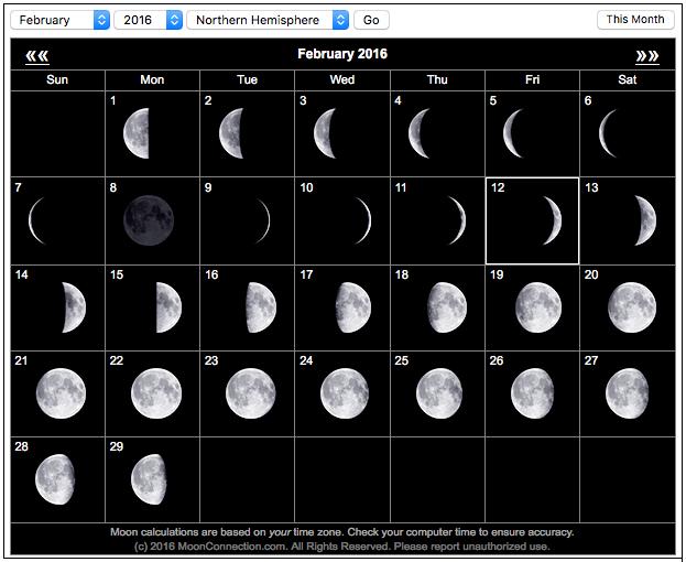
 The phase of the moon, b) The range of radiance values in each scene and where the maxima appear.")
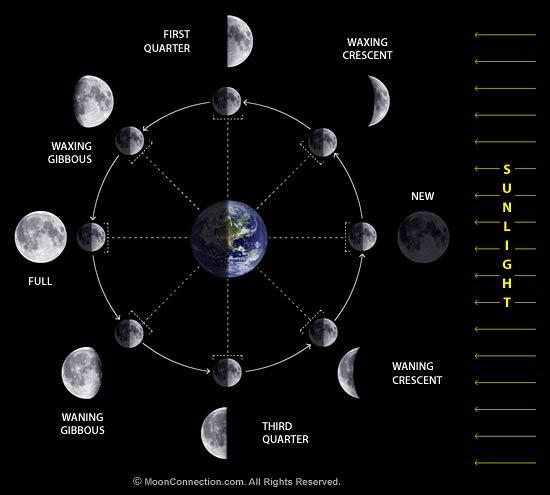
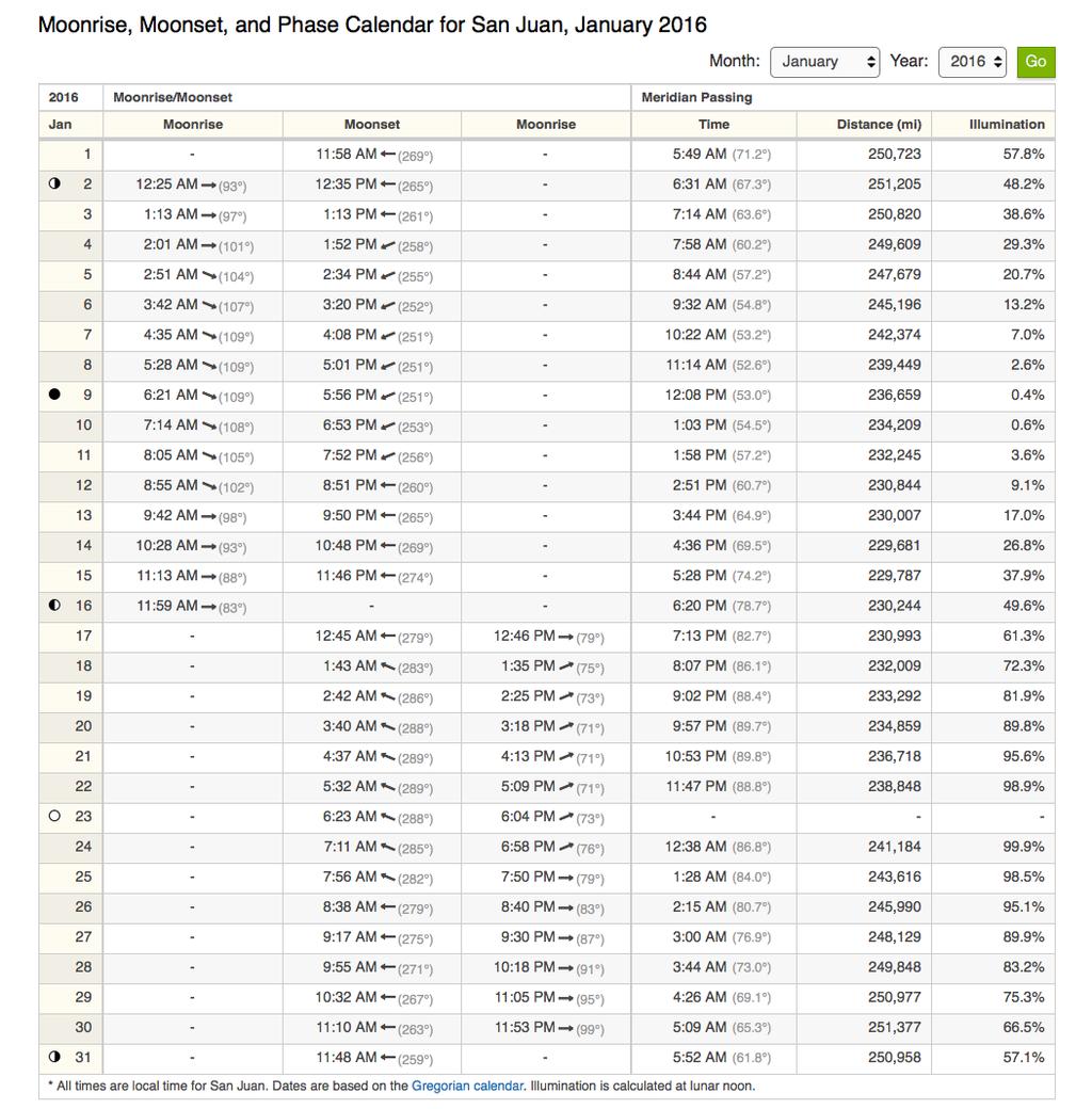
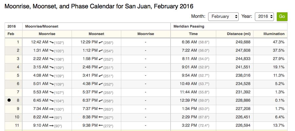
4 This lab invites you to investigate four different VIIRS Day/Night Band data sets representing 4 lunar illumination regimes over Puerto Rico and surrounding regions. As you examine these four data sets, note: a) The phase of the moon, b) The range of radiance values in each scene and where the maxima appear. b) How consistent the illumination is across the swath (why would this change across a scan?). c) What features can you see in the land/ocean/atmosphere and how do they vary depending on illumination? d) What advantages and disadvantages does this band have over standard infrared bands? You can use the following charts and table to help you. 4
5 5
6 6
7 7
8 8
A temporal active fire detection algorithm applied to geostationary satellite observations
 8 th 10 th June LSA-SAF Workshop 2015 A temporal active fire detection algorithm applied to geostationary satellite observations Gareth Roberts (University of Southampton) Outline Active fire detection
GOES-R AWG Land Team: Fire Detection and Characterization
 GOES-R AWG Land Team: Fire Detection and Characterization June 8, 2010 Presented By: Christopher C. Schmidt 1 1 UW-Madison/SSEC/CIMSS 1 FIRE Product Team AWG Land Team Chair: Yunyue (Bob) Yu FIRE Product
Wildfire Mapping Using FireBIRD Data
 Wildfire Mapping Using FireBIRD Data Global Wildfire Information System (GWIS) GOFC GOLD Fire IT 20-23 rd November 2017, Cumberland Lodge Christian Fischer on behalf of the FireBIRD-Team German Aerospace
PARALLEL USE OF SEVIRI LSA SAF FRP AND MPEF FIR PRODUCTS FOR FIRE DETECTION AND MONITORING
 PARALLEL USE OF SEVIRI LSA SAF FRP AND MPEF FIR PRODUCTS FOR FIRE DETECTION AND MONITORING C. G. Georgiev, J. S. Stoyanova National Institute of Meteorology and Hydrology, Bulgarian Academy of Sciences
There are various resources and toolkits available to perform this task.
 Hands-On Exercise: Wildfires in Chile, January 2017 Task description Imagine you are analyst that has been assigned to the fire Las Maquinas burning in the vicinity of Constitución, in the Maule region
Physical concepts. Remote sensing of fires and vegetation. Applications of SEVIRI channels.
 Physical concepts Remote sensing of fires and vegetation Applications of SEVIRI channels jose.prieto@eumetsat.int Contents Applications of SEVIRI channels Characteristics of the 3.9µm channel Differences
Verification and Validation of OOV-TET1 Multispectral Camera Observations within the FireBIRD Project
 DLR.de Chart 1 Verification and Validation of OOV-TET1 Multispectral Camera Observations within the FireBIRD Project O. Frauenberger **, A. Börner *, E. Borg **, W Halle *, E. Lorenz *, S. Mitchell *,
Smart Fire Prevention
 Smart Fire Prevention Using VIP Vision Thermal Cameras to Detect Fire Release 1.0 Contents 1 Introduction to Thermal Imaging... 2 2 Detecting Fires with VIP Vision Thermal Cameras... 3 2.1 Mode Selection...
FIRE DETECTION AND MONITORING USING AVHRRA AND MSG SYSTEMS. Version Tuesday, 1.0, 1530 November Slide: 1
 FIRE DETECTION AND MONITORING USING AVHRRA AND MSG SYSTEMS Version Tuesday, 1.0, 1530 November 2005 2004 Slide: 1 Botswana early warning system Version Tuesday, 1.0, 1530 November 2005 2004 Slide: 2 Objectives
Use of new spatially refined satellite remote sensing fire detection data in support of advanced wildfire mapping and modeling
 Use of new spatially refined satellite remote sensing fire detection data in support of advanced wildfire mapping and modeling Dr. Wilfrid Schroeder 1 Dr. Janice Coen 2 Dr. Patricia Oliva 1 Dr. Louis Giglio
Interim evaluation of the New IR Sensor Technology (NIRST) as a wildfire monitoring tool
 as a wildfire monitoring tool") Interim evaluation of the New IR Sensor Technology (NIRST) as a wildfire monitoring tool Joshua Johnston Forest Fire Analyst Canadian Forest Service Great Lakes Forestry Centre Sault Ste. Marie, Ontario
Interim evaluation of the New IR Sensor Technology (NIRST) as a wildfire monitoring tool Joshua Johnston Forest Fire Analyst Canadian Forest Service Great Lakes Forestry Centre Sault Ste. Marie, Ontario
S-NPP/VIIRS and Landsat-8/OLI Global Active Fire Data Sets
 S-NPP/VIIRS and Landsat-8/OLI Global Active Fire Data Sets Wilfrid Schroeder Louis Giglio, Pierre Guillevic, William Walsh (Dept of Geographical Sciences/UMD) Janice Coen (NCAR/Boulder) Ivan Csiszar (NOAA/NESDIS/STAR)
[Some] Updates on Research into Fire Radiative Power & Energy
![[Some] Updates on Research into Fire Radiative Power & Energy](/thumbs/89/100768239.jpg "[Some] Updates on Research into Fire Radiative Power & Energy") Environmental Monitoring & Modelling Research Group [Some] Updates on Research into Fire Radiative Power & Energy Presented by Martin Wooster (Kings College London, UK) Slide contributions from many others
Environmental Monitoring & Modelling Research Group [Some] Updates on Research into Fire Radiative Power & Energy Presented by Martin Wooster (Kings College London, UK) Slide contributions from many others
Review of MTG FDHSI Mission Requirements Regarding Fire Applications
 Review of MTG FDHSI Mission Requirements Regarding Fire Applications Dr M.J. Wooster and Dr G. Roberts Environmental Monitoring and Modelling Group, Department of Geography King s College London Document
CO 2, CH 4 and CO Observa0ons from CrIS on S-NPP and JPSS-1
 CO 2, CH 4 and CO Observa0ons from CrIS on S-NPP and JPSS-1 Xiaozhen (Shawn) Xiong 1,2, Lihang Zhou 2 Antonia Gambacorta 1,3, Nick Nalli 1,2, Changyi Tan 1,2 Flavio Iturbide-Sanchez 1,2, Kexing Zhang 1,2
GOFC/GOLD Fire IT Strategic Planning. Day 1 - Break Out Group Discussion
 GOFC/GOLD Fire IT Strategic Planning Day 1 - Break Out Group Discussion Aims of the Fire IT refining and articulating the international requirements for fire related observations making the best possible
Rapid Prototyping of NASA Next Generation Sensors for the SERVIR System of Fire Detection in Mesoamerica
 Rapid Prototyping of NASA Next Generation Sensors for the SERVIR System of Fire Detection in Mesoamerica Joel S. Kuszmaul, Henrique Momm, Greg Easson University of Mississippi, University, MS 38677 Timothy
GOES-R ABI Emissive IR Bands Radiometric Performance Monitoring and Trending
 GOES-R ABI Emissive IR Bands Radiometric Performance Monitoring and Trending Haifeng Qian a, Robert Iacovazzi a, Xiangqian Wu b, Boryana Efremova a, Fangfang Yu a, Xi Shao a a ERT, Inc. Laurel, MD 20707
NEAR REAL TIME DETECTION OF BURNED SCAR AREA USING LANDSAT-8 IMAGERIES
 NEAR REAL TIME DETECTION OF BURNED SCAR AREA USING LANDSAT-8 IMAGERIES Danang Surya Candra Kustiyo - Indonesian National Institute of Aeronautics and Space (LAPAN) - Outline INTRODUCTION: Background, Problems,
SEVIRI/MSG sensor early fire detection performances assessment
 SEVIRI/MSG sensor early fire detection performances assessment G. Laneve, E. Cadau CRPSM Università di Roma La Sapienza e-mail: laneve@psm.uniroma1.it 2 nd GOFC/GOLD Workshop on GEO Fire Monitoring, Darmstadt,
Fire Detection and Monitoring
 Fire Detection and Monitoring Akli Benali Forest Research Center, University of Lisbon aklibenali@gmail.com Conference & Summer School on Forest Fire Management Istituto Superiore Antincendi, Rome, September
 www.inpe.br/queimadas This (short) presentation will stress: - Interaction with users; - GOES-16 detections A system with dozens of diferent products www.inpe.br/queimadas Our new portal CIMAN combines
Recent Developments and Prospects for Innovative Remote Sensing of High-Temperature Events and Vegetation Fire Impacts
 Recent Developments and Prospects for Innovative Remote Sensing of High-Temperature Events and Vegetation Fire Impacts by D. Oertel, E. Lorenz, B. Zhukov German Aerospace Center, (DLR-OS) Berlin Adlershof
Development of a Canadian Wildland Fire Monitoring Sensor (CWFMS)
") Unclassified Development of a Canadian Wildland Fire Monitoring Sensor (CWFMS) Helena (Marleen) van Mierlo 1 Linh Ngo Phong 1 Steeve Montminy 1 Joshua M. Johnston 2 Denis Dufour 3 (1) Canadian Space Agency
Unclassified Development of a Canadian Wildland Fire Monitoring Sensor (CWFMS) Helena (Marleen) van Mierlo 1 Linh Ngo Phong 1 Steeve Montminy 1 Joshua M. Johnston 2 Denis Dufour 3 (1) Canadian Space Agency
VIIRS FIRE PRODUCTS UPDATE
 VIIRS FIRE PRODUCTS UPDATE Ivan Csiszar 1, Wilfrid Schroeder 2, Louis Giglio 2, Brad Wind 2, Evan Ellicott 2, Christopher O. Justice 2 1 NOAA/NESDIS Center for Satellite Applications and Research, Camp
DETECTION AND MONITORING OF ACTIVE FIRES USING REMOTE SENSING TECHNIQUES
 DETECTION AND MONITORING OF ACTIVE FIRES USING REMOTE SENSING TECHNIQUES Source: Unknown n.d., http://www.hotrodsandclassics.net/featuredpictures/featurepictures2.htm. by Claire Riddell DETECTION AND MONITORING
The operational MSG SEVIRI fire radiative power products generated at the Land-SAF
 Environmental Monitoring & Modelling Research Group The operational MSG SEVIRI fire radiative power products generated at the Land-SAF Martin Wooster, Gareth Roberts, Weidong Xu, Patrick Freeborn, Jianping
Global Biomass Burning Emissions from a Constellation of Geostationary Satellites for Global Model Forecast Applications
 1 Global Biomass Burning Emissions from a Constellation of Geostationary Satellites for Global Model Forecast Applications Shobha Kondragunta NOAA/NESDIS Center for Satellite Applications and Research
Application Note. Which characterization method is best for your application? The Future of Thermal Imaging is Here!!!
 Microsanj LLC 3287 Kifer Road Santa Clara, CA 95051 Application Note Comparing Thermoreflectance (TTI), Infrared (IR), Near Infrared Emission (EMMI), and Optical Beam Induced Resistance Change (OBIRCH)
Long-term Inventory of Fire Burned Areas and Emissions of North America s Boreal and Temperate Forests
 Long-term Inventory of Fire Burned Areas and Emissions of North America s Boreal and Temperate Forests P.Gong, Z. Li, I. Csiszar, W. Hao, R. Fraser J.Z. Jin, R. Pu Objectives 1. Map burn scars in boreal
Bringing Smarts to Methane Emissions Detection
 Bringing Smarts to Methane Emissions Detection An Update on the DOE Smart Methane Emissions Project Maria Araujo Manager R&D Southwest Research Institute Background Fugitive emissions from compressors
remote sensing ISSN
 Remote Sens. 2015, 7, 4473-4498; doi:10.3390/rs70404473 Article OPEN ACCESS remote sensing ISSN 2072-4292 www.mdpi.com/journal/remotesensing Forest Fire Smoke Detection Using Back-Propagation Neural Network
Standard for Infrared Inspection of Building Envelopes
 Standard for Infrared Inspection of Building Envelopes 2016 Edition Infraspection Institute 425 Ellis Street Burlington, NJ 08016 www.infraspection.com Standard for Infrared Inspection of Building Envelopes
Elaine M. Prins* NOAA/NESDIS, Office of Research and Applications, Advanced Satellite Products Branch (ASPB) Madison, WI
 Madison, WI") P4.6 Global Geostationary Fire Monitoring System Elaine M. Prins* NOAA/NESDIS, Office of Research and Applications, Advanced Satellite Products Branch (ASPB) Madison, WI Donna McNamara NOAA/NESDIS, Office
P4.6 Global Geostationary Fire Monitoring System Elaine M. Prins* NOAA/NESDIS, Office of Research and Applications, Advanced Satellite Products Branch (ASPB) Madison, WI Donna McNamara NOAA/NESDIS, Office
Polaris Sensor Technologies, Inc. Visible - Limited Detection Thermal - No Detection Polarization - Robust Detection etherm - Ultimate Detection
 Polaris Sensor Technologies, Inc. DETECTION OF OIL AND DIESEL ON WATER - Limited Detection - No Detection - Robust Detection etherm - Ultimate Detection Pyxis Features: Day or night real-time sensing Platform
P1.9 CHARACTERIZING AND UNDERSTANDING THE DIFFERENCES BETWEEN GOES WF_ABBA AND MODIS FIRE PRODUCTS AND IMPLICATIONS FOR DATA ASSIMILATION
 P1.9 CHARACTERIZING AND UNDERSTANDING THE DIFFERENCES BETWEEN GOES WF_ABBA AND MODIS FIRE PRODUCTS AND IMPLICATIONS FOR DATA ASSIMILATION Jay P. Hoffman 1 *, Elaine M. Prins 1, Christopher C. Schmidt 1,
Band Selection & Algorithm Development for Remote Sensing of Wildland Fires
 Band Selection & Algorithm Development for Remote Sensing of Wildland Fires Andy Fordham Chester F. Carlson Center for Imaging Science Rochester Institute of Technology Rochester, New York 14623-5604 ajf8207@cis
DEMONSTRATION OF A SEMI-OPERATIONAL FIRE RECOGNITION SERVICE USING BIRD MICRO- SATELLITE - DEMOBIRD
 DEMONSTRATION OF A SEMI-OPERATIONAL FIRE RECOGNITION SERVICE USING BIRD MICRO- SATELLITE - DEMOBIRD Jesús Gonzalo, Gonzalo Martín de Mercado Ingeniería y Servicios Aeroespaciales, S.A. (INSA), Spain Paseo
Analysing Threshold Value in Fire Detection Algorithm Using MODIS Data
 RESEARCH PAPER Analysing Threshold Value in Fire Detection Algorithm Using MODIS Data 1 Bowo E. Cahyono, 2 Peter Fearns, and 3 Brendon McAtee 1 Department of Physics, Jember University, Indonesia; 2 Department
Detection and analysis of high-temperature events in the BIRD mission
 Acta Astronautica 56 (2005) 65 71 www.elsevier.com/locate/actaastro Detection and analysis of high-temperature events in the BIRD mission Boris Zhukov, Klaus Briess, Eckehard Lorenz, Dieter Oertel, Wolfgang
Supplement of LSA SAF Meteosat FRP products Part 1: Algorithms, product contents, and analysis
 Supplement of Atmos. Chem. Phys., 15, 13217 13239, 2015 http://www.atmos-chem-phys.net/15/13217/2015/ doi:10.5194/acp-15-13217-2015-supplement Author(s) 2015. CC Attribution 3.0 License. Supplement of
Global fire hotspots detected by NASA satellite to help United Nations
 Global fire hotspots detected by NASA satellite to help United Nations Published on 24 Sep 2010 is Image NASA's not found Moderate or type unknown Resolution Imaging Spectroradiometer (MODIS), an instrument
Results on verification and validation of OOV-TET1 multispectral camera observations within the FireBIRD project
 Results on verification and validation of OOV-TET1 multispectral camera observations within the FireBIRD project O. Frauenberger **, E. Borg **, A. Börner *, W Halle *, E. Lorenz *, S. Mitchell *, C. Paproth
Security Management System - Configuring Video Analytics
 Introduction This document describes the steps for configuring the Video Analytics (VA) module available in the Security Management System software. Security Management System video analytics module is
TSI AEROTRAK PORTABLE PARTICLE COUNTER MODEL 9110
 TSI AEROTRAK PORTABLE PARTICLE COUNTER MODEL 9110 APPLICATION NOTE CC-107 Introduction This purpose of this document is to detail the advanced, state of the art features TSI has incorporated in the design
Fire-Implementation Team (Fire-IT) Update and Future Steps
 Update and Future Steps") Global Observation of Forest and Land Cover Dynamics Fire-Implementation Team (Fire-IT) Update and Future Steps Fire-IT Co-Chair: Chris Justice (U. Maryland) Fire-IT Executive Officer: Krishna Vadrevu
Global Observation of Forest and Land Cover Dynamics Fire-Implementation Team (Fire-IT) Update and Future Steps Fire-IT Co-Chair: Chris Justice (U. Maryland) Fire-IT Executive Officer: Krishna Vadrevu
Overview of the WF_ABBA Global Geostationary Fire Monitoring Program: Current Implementation and Future Plans
 Overview of the WF_ABBA Global Geostationary Fire Monitoring Program: Current Implementation and Future Plans Elaine M. Prins Consultant Christopher C. Schmidt Jay Hoffman Jason Brunner UW-Madison SSEC
Satellite Derived Fire Products for Biomass Burning Studies
 Satellite Derived Fire Products for Biomass Burning Studies Chris Justice University of Maryland and colleagues Fires in Indochina April 6 2010 ( NASA MODIS Aqua) THE GLOBAL FIRE PRODUCT (1992 93) bioval.jrc.ec.europa.eu/
1.1. SYSTEM MODELING
 1 INTRODUCTION Electro-optical imaging system analysis is a mathematical construct that provides an optimum design through appropriate trade studies. A comprehensive model includes the target, background,
Estimating Fire Properties by Remote Sensing 1.
 Estimating Fire Properties by Remote Sensing 1. Philip J. Riggan USDA Forest Service Pacific Southwest Research Station 4955 Canyon Crest Drive Riverside, CA 92507 909 680 1534 PJRiggan@IBM.net James W.
CATSI EDM A MILITARIZED SENSOR FOR PASSIVE STANDOFF DETECTION OF CWA
 CATSI EDM A MILITARIZED SENSOR FOR PASSIVE STANDOFF DETECTION OF CWA J. M.Thériault, H. Lavoie, F. Bouffard (DRDC Valcartier, Qc, Canada) P. Lacasse (AEREX Avionique Inc. Qc, Canada) The 10th CBW Protection
Research on Key Technologies of Photoelectric Guided Weapons and Their Development Trends
 Research on Key Technologies of Photoelectric Guided Weapons and Their Development Trends Abstract Helei Guo, Zhenya Liu and Yongtao Li China Huayin Ordnance Test Center, Box 801, Huayin City, Shaanxi
Daytime Fire Detection Using Airborne Hyperspectral Data Philip E. Dennison 1 and Dar A. Roberts 2. University of Utah, Salt Lake City, UT 84112, USA
 Daytime Fire Detection Using Airborne Hyperspectral Data Philip E. Dennison 1 and Dar A. Roberts 2 1 Department of Geography and Center for Natural and Technological Hazards, University of Utah, Salt Lake
Product data sheet Palas Fidas 200 S
 Product data sheet Palas Fidas 200 S Applications Regulatory environmental monitoring in measuring networks Ambient air measurement campaigns Oriented indicative measurements (spot checks) Long-term studies
metro B6012 VIBRATIONS SIMPLIFIED... Product brochure Easiest portable vibration analyzer and balancer TECHNOLOGIES PVT. LTD.
 metro B6012 VIBRATIONS SIMPLIFIED... Product brochure Easiest portable vibration analyzer and balancer TECHNOLOGIES PVT. LTD. Product brocure 1 is reliable, fast and easiest to use tool designed for routine
LEARNING SPECIAL HAZARD DETECTION TYPES
 LEARNING SPECIAL HAZARD DETECTION TYPES JUNE 2013 COPYRIGHT CLIMATEC SPECIAL HAZARDS DETECTION TYPES EXPLAINED STAGE ONE DETECTION - ACTIVE AIR SAMPLING\\INCIPIENT AND IN- VISIBLE SMOKE STAGE AIR SAMPLING
rvm4c Installation Guide Remote Video Module
 rvm4c EN Installation Guide Remote Video Module rvm4c Installation Guide Installation Diagrams EN 2 Installation Diagrams for the Transmitting Unit rvm4c Installation Guide Basic Hardware Installation
Portable Perimeter Detection and Monitoring System - PoPDaMS
 Portable Perimeter Detection and Monitoring System - PoPDaMS The A-Team by Elijah Adedire Monique Kirkman-Bey Ehimwenma Nosakhare March 9th 2011 Outline Background Problem Definition Design Requirements
Jupiter s Infrared Aurora
 Jupiter s Infrared Aurora Tom Stallard Magnetosphere Energetic particle precipitation H*, H 2 * 1 2 3 Magnetosphere Energetic particle precipitation H*, H 2 * H 2, CH 4 etc 1 2 3 Magnetosphere Energetic
ENVIRONMENTAL SYSTEMS 2 ARCH 373. LAB One: Tool Hour. a quick introduction to some of the readily available case study instrumentation
 ENVIRONMENTAL SYSTEMS 2 ARCH 373 LAB One: Tool Hour a quick introduction to some of the readily available case study instrumentation Ball State Architecture ENVIRONMENTAL SYSTEMS 2 Grondzik 1 INVESTIGATIVE
Product training FLIR K series for firefighters(k45, K55, K65)
") Product training FLIR K series for firefighters(k45, K55, K65) Disclaimer Dear Student, We kindly ask you to read the following carefully. Copyright ITC 2011. All rights reserved. This training material
Product training FLIR K series for firefighters(k45, K55, K65) Disclaimer Dear Student, We kindly ask you to read the following carefully. Copyright ITC 2011. All rights reserved. This training material
I am Rick Jeffress and I handle sales for Fike Video Image Detection. We thank the AFAA for coordinating the venue for this presentation, and we
 I am Rick Jeffress and I handle sales for Fike Video Image Detection. We thank the AFAA for coordinating the venue for this presentation, and we appreciate your taking the time to learn more about this
THE NEXT GENERATION IN VISIBILITY SENSORS OUTPERFORM BOTH TRADITIONAL TRANSMISSOMETERS AND FORWARD SCATTER SENSORS
 THE NEXT GENERATION IN VISIBILITY SENSORS OUTPERFORM BOTH TRADITIONAL TRANSMISSOMETERS AND FORWARD SCATTER SENSORS Steve Glander: Senior Sales Engineer All Weather, Inc. 1165 National Dr. Sacramento, CA
DEVELOPMENT OF THE INFRARED INSTRUMENT FOR GAS DETECTION
 DEVELOPMENT OF THE INFRARED INSTRUMENT FOR GAS DETECTION Ching-Wei Chen 1, Chia-Ray Chen 1 1 National Space Organization, National Applied Research Laboratories ABSTRACT MWIR (Mid-Wave Infrared) spectroscopy
Remote Gamma Imaging of High Dose Environments
 Remote Gamma Imaging of High Dose Environments Paul Griffiths Copyright BIL Solutions Ltd 2006. The copyright in this document is wholly vested in BIL Solutions Ltd who reserve all intellectual property
February 18, What is heat? Touch each image to see how the water molecules react.
 What is heat? Touch each image to see how the water molecules react. Where does heat come from? Touch each image and discuss. How can motion create heat? Touch each image to view the different energy levels
A bright alpha numeric display and the simplified keypad (three buttons) allow the operation even under harsh conditions.
 allow the operation even under harsh conditions.") Personal Alpha/Beta Continuous Air Monitor (CAM) The pocamon (personal online continuous air monitor) monitors continuously the breathing air to detect airborne radioactive aerosols (LLRD). Typical application
Personal Alpha/Beta Continuous Air Monitor (CAM) The pocamon (personal online continuous air monitor) monitors continuously the breathing air to detect airborne radioactive aerosols (LLRD). Typical application
Welcome to MultiSight TM Vision Sensor Hands-On Lab
 Welcome to MultiSight TM Vision Sensor Hands-On Lab About This Hands-On Lab Welcome to the MultiSight TM Vision Sensor Hands-On Lab! This session provides you with an opportunity to explore the functionality
Google-Earth use as a monitoring tool for EUMETSAT s active fire product
 Google-Earth use as a monitoring tool for EUMETSAT s active fire product Assist.Prof. İbrahim SÖNMEZ Ondokuz Mayıs University Department of Meteorology Samsun, TURKEY isonmez@omu.edu.tr 1 OUTLINE Google-Earth
UL268 7 th challenge with single infrared smoke detector
 UL268 7 th challenge with single infrared smoke detector Hans Aebersold Siemens Schweiz AG, Building Technologies Division, Switzerland Abstract Coming up UL217 8th and UL268 7th edition with added new
Evaluation of remote sensing-based active fire datasets in Indonesia
 INT. J. REMOTE SENSING, 20JANUARY, 2004, VOL. 25, NO. 2, 471 479 Evaluation of remote sensing-based active fire datasets in Indonesia F. STOLLE*{, R. A. DENNIS{, I. KURNIWAN{ and E. F. LAMBIN {Global Forest
Equipment Required. WaveRunner Zi series Oscilloscope 10:1 High impedance passive probe. 3. Turn off channel 2.
 FFT Analysis TEN MINUTE TUTORIAL February 27, 2012 Summary Fast Fourier Transform analysis is common on most digital oscilloscopes. It is used to view signals in the frequency as well as the time domain.
UWB Stepped-FM Sensor for Home Security
 SAS2012 UWB Stepped-FM Sensor for Home Security Y. Ota, R. Nakamura, and A. Kajiwara Graduate School of Environmental Engineering, The University of Kitakyushu, Japan Kajiwara lab. Overview Background
How SWIR Imaging contributes to the optimization of automatic quality control in the food industry
 How SWIR Imaging contributes to the optimization of automatic quality control in the food industry 2013 Overview Xenics in Short New Architecture Products Line Overview Visionlink Infrared Seminar 2013
Presentation Title October 18, Physical Sciences Inc. 20 New England Business Center Andover, MA Outline
 Physical Sciences Inc. Standoff detection of trace level explosive residue using passive LWIR hyperspectral imaging B.R. Cosofret, T.E. Janov, M. Costolo, S. Chang, W.J. Marinelli, R. Moro, D. Brown, and
A Cost Effective Multi-Spectral Scanner for Natural Gas Detection
 A Cost Effective Multi-Spectral Scanner for Natural Gas Detection Semi-Annual Progress Report No. 1 Reporting Period Start Date: October 1, 2003 Reporting Period End Date: March 31, 2004 Principal Authors:
Using VIIRS Direct Readout Capabilities for the Improvement of Mexico's Wild Fire Alert System
 Using VIIRS Direct Readout Capabilities for the Improvement of Mexico's Wild Fire Alert System Juan M. Escamilla Mólgora 1 National Commission for Knowledge and Use of Biodiversity CONABIO - Mexico 1 CSPP/IMAPP
Wildland fire phenomenology experiments:
 Wildland fire phenomenology experiments: 2001-2002 RIT: Bob Kremens Stef VanGorden Andy Fordham Bryce Nordgren Dave Pogolarza Adam Cisz RMSC: Dan Latham Colin Hardy Brett Butler We plan to measure unknown
T2SL technology for Mid-IR detectors
 T2SL technology for Mid-IR detectors Linda Höglund Minerva Workshop June, 30 th 1 Outline Introduction Tasks in MINERVA Starting point: MW detectors 320 256 on 30 µm pitch Technologies developed in MINERVA
Module multisensor system for strategic objects protection
 Data Mining X 123 Module multisensor system for strategic objects protection M. Życzkowski, M. Szustakowski, M. Kastek, W. Ciurapiński & T. Sosnowski Institute of Optoelectronics, Military University of
Bright, Chromatic and Distinct - Perception and Detection of LED-based Airfield Lighting
 Bright, Chromatic and Distinct - Perception and Detection of LED-based Airfield Lighting October 21, 2010 IES-ALC conference Seaview Resort, Galloway, NJ Sara Bergsten, PhD, Optical Designer Outline Perception
Methane to Markets Oil and Natural Gas Technology Transfer Workshop
 Methane to Markets Oil and Natural Gas Technology Transfer Workshop Detection and Measurement of Fugitive Emissions Using Airborne Differential Absorption Lidar (DIAL) Daniel Brake ANGEL Service ITT Space
Sentinel-1A Product Geolocation Accuracy: Beyond the Calibration Phase
 Sentinel-1A Product Geolocation Accuracy: Beyond the Calibration Phase 27 October 2015 Adrian Schubert, David Small (UZH), Nuno Miranda (ESA-ESRIN), Dirk Geudtner (ESA-ESTEC), Erich Meier (UZH) Page 1
Executive Summary. Houston Museum of American Art New York, New York
 Executive Summary This proposal details the work to be completed in the spring of 2013. It presents a description of the redesign of several systems present in the. Included are explanations of two depth
The Role of Satellite Observations in Assessing Impacts of Wildfire Occurrence on Respiratory Health of Population
 The Role of Satellite Observations in Assessing Impacts of Wildfire Occurrence on Respiratory Health of Population Tatiana Loboda University of Maryland Outline Wildfire and human health Interdisciplinary
National Infrared Operations (NIROPS) Program Overview. Tom Mellin National Infrared Program Manager
 Program Overview. Tom Mellin National Infrared Program Manager") National Infrared Operations (NIROPS) Program Overview Tom Mellin National Infrared Program Manager Topics NIROPS organization Phoenix imaging system Aircraft Data delivery to infrared interpreters IRIN
National Infrared Operations (NIROPS) Program Overview Tom Mellin National Infrared Program Manager Topics NIROPS organization Phoenix imaging system Aircraft Data delivery to infrared interpreters IRIN
Wireless Weather Station with Solar Transmitter Instruction Manual
 Wireless Weather Station with Solar Transmitter Instruction Manual Table of Contents Page 1. Introduction...2 2. Inventory of contents......2 Feature of the base station.... 2 Feature of wind sensor...
Developing Early Design Simulation Tools For Persons with Vision Impairments
 Developing Early Design Simulation Tools For Persons with Vision Impairments James R. Jones, Ph.D. Professor Center for High Performance Environments, Virginia Tech Vidya Gowda College of Architecture
Smoke and Fire Detection
 International Journal of Scientific and Research Publications, Volume 4, Issue 7, July 2014 1 Smoke and Fire Detection Dr. (Mrs.) Saylee Gharge *, Sumeet Birla **, Sachin Pandey **, Rishi Dargad **, Rahul
XEUS mirror calibration:
 XEUS mirror calibration: The PANTER X-ray Test Facility: accommodation of optics with long focal lengths etc., Wolfgang Burkert, Gisela Hartner, Bernd Budau XEUS Workshop, ESA, ESTEC, Noordwijk, 05-06
Chapter 2 Background. 2.1 VID Technology
 Chapter 2 Background 2.1 VID Technology In general, a fire VID system consists of video-based analytical algorithms that integrate cameras into advanced flame and smoke detection systems. The video image
Advanced Fire Information System
 Advanced Fire Information System Karen Steenkamp Philip Frost CSIR Meraka Institute www.sac.co.za Meraka Institute - RSRU RSRU Mission: To conduct basic and applied remote sensing research for the advancement
The FireBird mission - a scientific mission for Earth observation and hot spot detection
 The FireBird mission - a scientific mission for Earth observation and hot spot detection Terzibaschian, Thomas Reile, H., Lorenz, E. DLR, Germany 9th IAA SYMPOSIUM ON SMALL SATELLITES FOR EARTH OBSERVATION,
Datasheet Crowd Management
 Datasheet Crowd Management Version 3.78 This Specification Sheet gives the details of system requirements, feature details and other salient points of AllGoVision s Crowd Management applications. Revision
Evaluating Chicago s Urban Heat Island Policy with Remote Sensing. Chris Mackey
 Evaluating Chicago s Urban Heat Island Policy with Remote Sensing Chris Mackey The Heat Island Effect When a large urban area is a few degrees warmer than its surrounding rural area. Composed from LANDSAT
Fire Detection System using Matlab
 Fire Detection System using Matlab Chandrakant Shrimantrao 1, Mahesh S K 2, Vivekanand M Bonal 3 1 Fourth Sem M.Tech, 2 Asst. Professor, Appa Institute of Engineering and Technology Karnataka, 3 Head,
THE GLARE EVALUATION METHOD FOR CIVIL AIRPLANE FLIGHT DECK
 28 TH INTERNATIONAL CONGRESS OF THE AERONAUTICAL SCIENCES THE GLARE EVALUATION METHOD FOR CIVIL AIRPLANE FLIGHT DECK Ma Zhi, Zhang Wei, Li Hui School of Aeronautics, Northwestern Polytechnical University
RLDS - Remote LEAK DETECTION SYSTEM
 RLDS - Remote LEAK DETECTION SYSTEM Asel-Tech has spent considerable time and resources over the past 8 years to improve our technology, to the point where it is unparalleled in reliability and performance
Date: Wednesday, January 31, 2018 Time: 8:30 am 5:00 pm Location: Moscone West (Room 2018, Level 2)
") Optics Lasers Detectors FREE WORKshops Date: Wednesday, January 31, 2018 Time: 8:30 am 5:00 pm Location: Moscone West (Room 2018, Level 2) The team from LASER COMPONENTS is holding a free one-day workshop
Optics Lasers Detectors FREE WORKshops Date: Wednesday, January 31, 2018 Time: 8:30 am 5:00 pm Location: Moscone West (Room 2018, Level 2) The team from LASER COMPONENTS is holding a free one-day workshop
Stand-off Detection of Trace Explosives by Infrared Photothermal Imaging. Trace Contamination
 Stand-off Detection of Trace Explosives by Infrared Photothermal Imaging Chris Kendziora, Robert Furstenberg, Michael Papantonakis, Jennifer Stepnowski, Viet Nguyen and R. Andrew McGill US Materials and