A temporal active fire detection algorithm applied to geostationary satellite observations
|
|
|
- Wesley Bruce
- 5 years ago
- Views:
Transcription

1 8 th 10 th June LSA-SAF Workshop 2015 A temporal active fire detection algorithm applied to geostationary satellite observations Gareth Roberts (University of Southampton)
2 Outline Active fire detection Geostationary active fire detection Multi-temporal active fire detection approach Modelling diurnal temperature cycle Background characterisation Active fire detections Comparison to MODIS Conclusion

3 Active Fire Detection Strong heritage 1 st demonstrated in 1981 using NOAA AVHRR Detect location of actively burning fires uses MIR & TIR wavebands exploits high sensitivity of MIR channel to fire thermal emissions Thermal measurements used to characterise fire effective fire temperature and area Fire Radiative Power (FRP)

4 Most operational fire detection algorithms are contextual applied to both polar and geostationary instruments Contextual active fire detection Uses MIR & TIR observations exploits high & low sensitivity of MIR & TIR channels to fire thermal emissions 3.9 microns 11 microns DT difference (fires contribution) Potential fire pixel (PFP) if DT > chosen threshold Apply neighbourhood operations to surrounding pixels assess PFP temperature elevation against surrounding pixels dynamically adjust thresholds -> more scene dependent

5 Geostationary active fire detection Geostationary instruments Operational Longer time-series High temporal resolution observes diurnal fire cycle NRT application Low spatial resolution omission of small/low intensity fires Pixel saturation issues ~335K most GEO SEVIRI MIR channel timeseries : Fires are white/bright
6
7 Multi-temporal active fire algorithm exploit geostationary temporal information leverages off contextual active fire detections Improve : 1. active fire detection sensitivity 2. background characterisation characterises of the fire (e.g FRP) est. fuel consumption confirms true fire detection uncertainty increased by : landcover heterogeneity instrument characteristics PSF, FIR Can lead to large differences in FRP up to 82% (Schroeder et al., 2010 JGR) Two components : 1. model diurnal cycle MIR brightness temperature (BT) non-fire affected obs. 2. Standard Kalman Filter account for errors in modelled DTC BT Roberts and Wooster (2014) RSE
8 Udahemuka et al., (2007), van den Bergh and Frost (2007); van den Bergh et al. (2009), IEEE TGRS Multi-temporal active fire algorithm : Modelling DTC DTC modelled using training dataset 10 input DTCs from current pixel ~cloud and fire free contextual detections to identify active fire <8 cloudy pixels Singular Value Decomposition characterise temporal variation of pixel DTC least squares estimate of obs. DTC
9 Multi-temporal active fire algorithm : Standard Kalman Filter modelled DTC is the process model Kalman Gain 0 fire or cloud affected observations propagated using modelled DTC only Fire detection MIR obs -MIR mod 1K BT threshold varies with MSE Kalman Filter
10 Multi-temporal active fire algorithm : Modelling DTC Modelled DTC Mean DTC DTC modelled only when : <8 fire affected obs. & <40 cloudy obs. Mean or previous modelled DTC used based on training dataset
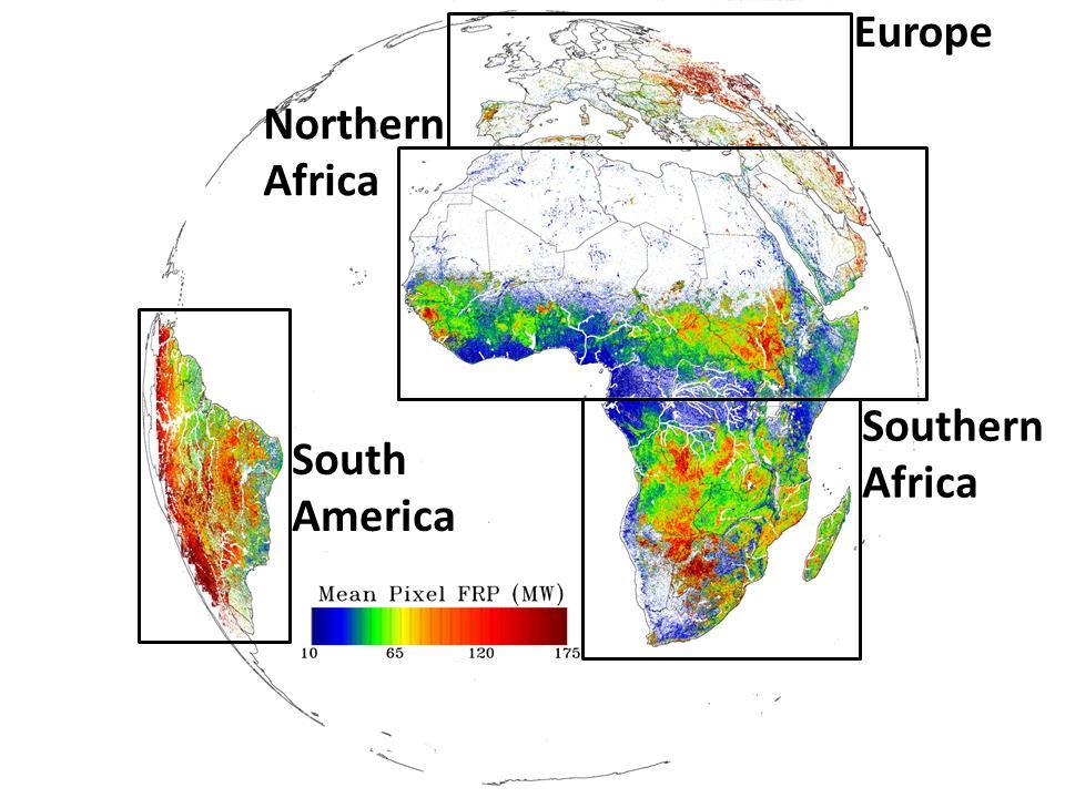
11 KF background BT (K) Contextual BT (K) Multi-temporal active fire algorithm : Background Characterisation Applied to 1 month SEVIRI data August (2004) 15 min resolution southern hemisphere Africa Compared to MIR observations contextual fire detection algorithm background BT estimates fire detections & FRP Observed BT (K) Both have low bias & scatter KF marginal improvement Observed BT (K)

12 Multi-temporal active fire algorithm : Fire detections
13 Multi-temporal active fire algorithm : Fire detections KF detects > number of fires (~1 million fire obs.) mostly low intensity fires (<30MW) Lower relative improvement in fuel consumption ~20% (8Tg) BUT in a month where fires occur in locations where SEVIRI pixel area is large

14 Background Characterisation : SEVIRI PSF impact Background characterisation important for fire detection and FRP measurement Compared KF modelled MIR BT against obs. BT around detected fire pixels Note : 3 3 pixel window surrounding active fire pixel not used for background characterisation in LSA-SAF FRP product
15 Multi-temporal active fire algorithm : Comparison to MODIS Kalman Filter detects many more MODIS detections than contextual algorithm 73,000 & 41,000 BUT much higher false alarm rate (16% compared to 8%)
16 Multi-temporal active fire algorithm : conclusion Multi-temporal algorithms offer some benefits Detects > of active fires Lower intensity 20% increase in monthly fuel consumption Marginal improvement in background characterisation However : high error of commission limits of geostationary fire detection reached. future GEO satellites offer higher spatial & temporal resolution Better integration with contextual fire detection approach may yield best results

17 Thanks to EUMETSAT, LSA-SAF & NASA for providing data

18 MWIR SEVIRI image over large fire MWIR pixel BT transect across Active fire


19 Wildfire Fires have high temperatures compared to ambient surroundings High temperatures result in very intense radiant energy emissions particularly in the middle IR (3-5 m) spectral region. Fire MIR emission so strong that fires of pixel are detectable. smoke
PARALLEL USE OF SEVIRI LSA SAF FRP AND MPEF FIR PRODUCTS FOR FIRE DETECTION AND MONITORING
 PARALLEL USE OF SEVIRI LSA SAF FRP AND MPEF FIR PRODUCTS FOR FIRE DETECTION AND MONITORING C. G. Georgiev, J. S. Stoyanova National Institute of Meteorology and Hydrology, Bulgarian Academy of Sciences
The operational MSG SEVIRI fire radiative power products generated at the Land-SAF
 Environmental Monitoring & Modelling Research Group The operational MSG SEVIRI fire radiative power products generated at the Land-SAF Martin Wooster, Gareth Roberts, Weidong Xu, Patrick Freeborn, Jianping
[Some] Updates on Research into Fire Radiative Power & Energy
![[Some] Updates on Research into Fire Radiative Power & Energy](/thumbs/89/100768239.jpg "[Some] Updates on Research into Fire Radiative Power & Energy") Environmental Monitoring & Modelling Research Group [Some] Updates on Research into Fire Radiative Power & Energy Presented by Martin Wooster (Kings College London, UK) Slide contributions from many others
Environmental Monitoring & Modelling Research Group [Some] Updates on Research into Fire Radiative Power & Energy Presented by Martin Wooster (Kings College London, UK) Slide contributions from many others
Global Biomass Burning Emissions from a Constellation of Geostationary Satellites for Global Model Forecast Applications
 1 Global Biomass Burning Emissions from a Constellation of Geostationary Satellites for Global Model Forecast Applications Shobha Kondragunta NOAA/NESDIS Center for Satellite Applications and Research
Review of MTG FDHSI Mission Requirements Regarding Fire Applications
 Review of MTG FDHSI Mission Requirements Regarding Fire Applications Dr M.J. Wooster and Dr G. Roberts Environmental Monitoring and Modelling Group, Department of Geography King s College London Document
University of Puerto Rico at Mayagüez Direct Broadcast Polar Orbiter Workshop
 University of Puerto Rico at Mayagüez Direct Broadcast Polar Orbiter Workshop 27 April 2016 Lab 2 Part 4: Investigating VIIRS and MODIS Fire Detection Capabilities 1.1. Use Hydra to open the VIIRS directory
SEVIRI/MSG sensor early fire detection performances assessment
 SEVIRI/MSG sensor early fire detection performances assessment G. Laneve, E. Cadau CRPSM Università di Roma La Sapienza e-mail: laneve@psm.uniroma1.it 2 nd GOFC/GOLD Workshop on GEO Fire Monitoring, Darmstadt,
Ivan Csiszar, Martin Wooster
 Global Geostationary Network Ivan Csiszar, Martin Wooster Recommendations from 2 nd workshop Research and Product Development Continue data fusion efforts and characterization Encourage products based
Supplement of LSA SAF Meteosat FRP products Part 1: Algorithms, product contents, and analysis
 Supplement of Atmos. Chem. Phys., 15, 13217 13239, 2015 http://www.atmos-chem-phys.net/15/13217/2015/ doi:10.5194/acp-15-13217-2015-supplement Author(s) 2015. CC Attribution 3.0 License. Supplement of
GOFC/GOLD Fire IT Strategic Planning. Day 1 - Break Out Group Discussion
 GOFC/GOLD Fire IT Strategic Planning Day 1 - Break Out Group Discussion Aims of the Fire IT refining and articulating the international requirements for fire related observations making the best possible
Recent Developments and Prospects for Innovative Remote Sensing of High-Temperature Events and Vegetation Fire Impacts
 Recent Developments and Prospects for Innovative Remote Sensing of High-Temperature Events and Vegetation Fire Impacts by D. Oertel, E. Lorenz, B. Zhukov German Aerospace Center, (DLR-OS) Berlin Adlershof
GOES-R AWG Land Team: Fire Detection and Characterization
 GOES-R AWG Land Team: Fire Detection and Characterization June 8, 2010 Presented By: Christopher C. Schmidt 1 1 UW-Madison/SSEC/CIMSS 1 FIRE Product Team AWG Land Team Chair: Yunyue (Bob) Yu FIRE Product
Development of a Canadian Wildland Fire Monitoring Sensor (CWFMS)
") Unclassified Development of a Canadian Wildland Fire Monitoring Sensor (CWFMS) Helena (Marleen) van Mierlo 1 Linh Ngo Phong 1 Steeve Montminy 1 Joshua M. Johnston 2 Denis Dufour 3 (1) Canadian Space Agency
Unclassified Development of a Canadian Wildland Fire Monitoring Sensor (CWFMS) Helena (Marleen) van Mierlo 1 Linh Ngo Phong 1 Steeve Montminy 1 Joshua M. Johnston 2 Denis Dufour 3 (1) Canadian Space Agency
DETECTION AND MONITORING OF ACTIVE FIRES USING REMOTE SENSING TECHNIQUES
 DETECTION AND MONITORING OF ACTIVE FIRES USING REMOTE SENSING TECHNIQUES Source: Unknown n.d., http://www.hotrodsandclassics.net/featuredpictures/featurepictures2.htm. by Claire Riddell DETECTION AND MONITORING
Interim evaluation of the New IR Sensor Technology (NIRST) as a wildfire monitoring tool
 as a wildfire monitoring tool") Interim evaluation of the New IR Sensor Technology (NIRST) as a wildfire monitoring tool Joshua Johnston Forest Fire Analyst Canadian Forest Service Great Lakes Forestry Centre Sault Ste. Marie, Ontario
Interim evaluation of the New IR Sensor Technology (NIRST) as a wildfire monitoring tool Joshua Johnston Forest Fire Analyst Canadian Forest Service Great Lakes Forestry Centre Sault Ste. Marie, Ontario
Elaine M. Prins* NOAA/NESDIS, Office of Research and Applications, Advanced Satellite Products Branch (ASPB) Madison, WI
 Madison, WI") P4.6 Global Geostationary Fire Monitoring System Elaine M. Prins* NOAA/NESDIS, Office of Research and Applications, Advanced Satellite Products Branch (ASPB) Madison, WI Donna McNamara NOAA/NESDIS, Office
P4.6 Global Geostationary Fire Monitoring System Elaine M. Prins* NOAA/NESDIS, Office of Research and Applications, Advanced Satellite Products Branch (ASPB) Madison, WI Donna McNamara NOAA/NESDIS, Office
Verification and Validation of OOV-TET1 Multispectral Camera Observations within the FireBIRD Project
 DLR.de Chart 1 Verification and Validation of OOV-TET1 Multispectral Camera Observations within the FireBIRD Project O. Frauenberger **, A. Börner *, E. Borg **, W Halle *, E. Lorenz *, S. Mitchell *,
 www.inpe.br/queimadas This (short) presentation will stress: - Interaction with users; - GOES-16 detections A system with dozens of diferent products www.inpe.br/queimadas Our new portal CIMAN combines
Long-term Inventory of Fire Burned Areas and Emissions of North America s Boreal and Temperate Forests
 Long-term Inventory of Fire Burned Areas and Emissions of North America s Boreal and Temperate Forests P.Gong, Z. Li, I. Csiszar, W. Hao, R. Fraser J.Z. Jin, R. Pu Objectives 1. Map burn scars in boreal
Methods of detecting burnt area and estimating emissions Dr. Kevin Tansey
 Methods of detecting burnt area and estimating emissions Dr. Kevin Tansey (kjt7@le.ac.uk) Why fire is important Emitter of GHG and aerosols into the atmosphere Stohl, A. et al., 2006, record high air pollution
Band Selection & Algorithm Development for Remote Sensing of Wildland Fires
 Band Selection & Algorithm Development for Remote Sensing of Wildland Fires Andy Fordham Chester F. Carlson Center for Imaging Science Rochester Institute of Technology Rochester, New York 14623-5604 ajf8207@cis
Detection and analysis of high-temperature events in the BIRD mission
 Acta Astronautica 56 (2005) 65 71 www.elsevier.com/locate/actaastro Detection and analysis of high-temperature events in the BIRD mission Boris Zhukov, Klaus Briess, Eckehard Lorenz, Dieter Oertel, Wolfgang
P1.9 CHARACTERIZING AND UNDERSTANDING THE DIFFERENCES BETWEEN GOES WF_ABBA AND MODIS FIRE PRODUCTS AND IMPLICATIONS FOR DATA ASSIMILATION
 P1.9 CHARACTERIZING AND UNDERSTANDING THE DIFFERENCES BETWEEN GOES WF_ABBA AND MODIS FIRE PRODUCTS AND IMPLICATIONS FOR DATA ASSIMILATION Jay P. Hoffman 1 *, Elaine M. Prins 1, Christopher C. Schmidt 1,
Fire-Implementation Team (Fire-IT) Update and Future Steps
 Update and Future Steps") Global Observation of Forest and Land Cover Dynamics Fire-Implementation Team (Fire-IT) Update and Future Steps Fire-IT Co-Chair: Chris Justice (U. Maryland) Fire-IT Executive Officer: Krishna Vadrevu
Global Observation of Forest and Land Cover Dynamics Fire-Implementation Team (Fire-IT) Update and Future Steps Fire-IT Co-Chair: Chris Justice (U. Maryland) Fire-IT Executive Officer: Krishna Vadrevu
FIRE DETECTION AND MONITORING USING AVHRRA AND MSG SYSTEMS. Version Tuesday, 1.0, 1530 November Slide: 1
 FIRE DETECTION AND MONITORING USING AVHRRA AND MSG SYSTEMS Version Tuesday, 1.0, 1530 November 2005 2004 Slide: 1 Botswana early warning system Version Tuesday, 1.0, 1530 November 2005 2004 Slide: 2 Objectives
Analysing Threshold Value in Fire Detection Algorithm Using MODIS Data
 RESEARCH PAPER Analysing Threshold Value in Fire Detection Algorithm Using MODIS Data 1 Bowo E. Cahyono, 2 Peter Fearns, and 3 Brendon McAtee 1 Department of Physics, Jember University, Indonesia; 2 Department
Physical concepts. Remote sensing of fires and vegetation. Applications of SEVIRI channels.
 Physical concepts Remote sensing of fires and vegetation Applications of SEVIRI channels jose.prieto@eumetsat.int Contents Applications of SEVIRI channels Characteristics of the 3.9µm channel Differences
Use of new spatially refined satellite remote sensing fire detection data in support of advanced wildfire mapping and modeling
 Use of new spatially refined satellite remote sensing fire detection data in support of advanced wildfire mapping and modeling Dr. Wilfrid Schroeder 1 Dr. Janice Coen 2 Dr. Patricia Oliva 1 Dr. Louis Giglio
Fire Detection and Monitoring
 Fire Detection and Monitoring Akli Benali Forest Research Center, University of Lisbon aklibenali@gmail.com Conference & Summer School on Forest Fire Management Istituto Superiore Antincendi, Rome, September
SAF for Land Surface Analysis (LSA SAF)
") SAF for Land Surface Analysis (LSA SAF) VALIDATION REPORT Fire Radiative Power (LSA-502 and LSA-503) Reference Number: SAF/LAND/IM/VR_FRP/V_10 Issue/Revision Index: Issue I/2015 FRP Pixel Algorithm Version:
SAF for Land Surface Analysis (LSA SAF) VALIDATION REPORT Fire Radiative Power (LSA-502 and LSA-503) Reference Number: SAF/LAND/IM/VR_FRP/V_10 Issue/Revision Index: Issue I/2015 FRP Pixel Algorithm Version:
Results on verification and validation of OOV-TET1 multispectral camera observations within the FireBIRD project
 Results on verification and validation of OOV-TET1 multispectral camera observations within the FireBIRD project O. Frauenberger **, E. Borg **, A. Börner *, W Halle *, E. Lorenz *, S. Mitchell *, C. Paproth
16.10 Johannes Kaiser HALO Proposal
 MINUTES OF THE DISCUSSION SESSION ON WILDFIRES & BIOMASS BURNING at the GEMS Annual Assembly 2006: Monday, 6th February, 13.30-17.00 Minutes by: Christiane Textor, Johannes Kaiser, and Martin Schultz AGENDA
NEAR REAL TIME DETECTION OF BURNED SCAR AREA USING LANDSAT-8 IMAGERIES
 NEAR REAL TIME DETECTION OF BURNED SCAR AREA USING LANDSAT-8 IMAGERIES Danang Surya Candra Kustiyo - Indonesian National Institute of Aeronautics and Space (LAPAN) - Outline INTRODUCTION: Background, Problems,
S-NPP/VIIRS and Landsat-8/OLI Global Active Fire Data Sets
 S-NPP/VIIRS and Landsat-8/OLI Global Active Fire Data Sets Wilfrid Schroeder Louis Giglio, Pierre Guillevic, William Walsh (Dept of Geographical Sciences/UMD) Janice Coen (NCAR/Boulder) Ivan Csiszar (NOAA/NESDIS/STAR)
Validating the TET-1 satellite sensing system in detecting and characterizing active fire hotspots
 Validating the TET-1 satellite sensing system in detecting and characterizing active fire hotspots A thesis submitted in fulfilment of the requirements for the degree of Master of Science Simon Stuart
DEMONSTRATION OF A SEMI-OPERATIONAL FIRE RECOGNITION SERVICE USING BIRD MICRO- SATELLITE - DEMOBIRD
 DEMONSTRATION OF A SEMI-OPERATIONAL FIRE RECOGNITION SERVICE USING BIRD MICRO- SATELLITE - DEMOBIRD Jesús Gonzalo, Gonzalo Martín de Mercado Ingeniería y Servicios Aeroespaciales, S.A. (INSA), Spain Paseo
Overview of the WF_ABBA Global Geostationary Fire Monitoring Program: Current Implementation and Future Plans
 Overview of the WF_ABBA Global Geostationary Fire Monitoring Program: Current Implementation and Future Plans Elaine M. Prins Consultant Christopher C. Schmidt Jay Hoffman Jason Brunner UW-Madison SSEC
There are various resources and toolkits available to perform this task.
 Hands-On Exercise: Wildfires in Chile, January 2017 Task description Imagine you are analyst that has been assigned to the fire Las Maquinas burning in the vicinity of Constitución, in the Maule region
Satellite Derived Fire Products for Biomass Burning Studies
 Satellite Derived Fire Products for Biomass Burning Studies Chris Justice University of Maryland and colleagues Fires in Indochina April 6 2010 ( NASA MODIS Aqua) THE GLOBAL FIRE PRODUCT (1992 93) bioval.jrc.ec.europa.eu/
Rapid Prototyping of NASA Next Generation Sensors for the SERVIR System of Fire Detection in Mesoamerica
 Rapid Prototyping of NASA Next Generation Sensors for the SERVIR System of Fire Detection in Mesoamerica Joel S. Kuszmaul, Henrique Momm, Greg Easson University of Mississippi, University, MS 38677 Timothy
GOES-R ABI Emissive IR Bands Radiometric Performance Monitoring and Trending
 GOES-R ABI Emissive IR Bands Radiometric Performance Monitoring and Trending Haifeng Qian a, Robert Iacovazzi a, Xiangqian Wu b, Boryana Efremova a, Fangfang Yu a, Xi Shao a a ERT, Inc. Laurel, MD 20707
Space-borne high resolution fire remote sensing in Benin, West Africa
 INT. J. REMOTE SENSING, 10 JUNE, 2004, VOL. 25, NO. 11, 2209 2216 Space-borne high resolution fire remote sensing in Benin, West Africa D. OERTEL, B. ZHUKOV DLR-Institute of Space Sensor Technology and
A Review of AVHRR-based Active Fire Detection Algorithms: Principles, Limitations, and Recommendations
 A Review of AVHRR-based Active Fire Detection Algorithms: Principles, Limitations, and Recommendations Z. Li 1, Y. J. Kaufman 2, C. Ichoku 2, R. Fraser 1, A. Trishchenko 1, L. Giglio 2, J. Jin 1, X. Yu
Wildfire Mapping Using FireBIRD Data
 Wildfire Mapping Using FireBIRD Data Global Wildfire Information System (GWIS) GOFC GOLD Fire IT 20-23 rd November 2017, Cumberland Lodge Christian Fischer on behalf of the FireBIRD-Team German Aerospace
The Role of Satellite Observations in Assessing Impacts of Wildfire Occurrence on Respiratory Health of Population
 The Role of Satellite Observations in Assessing Impacts of Wildfire Occurrence on Respiratory Health of Population Tatiana Loboda University of Maryland Outline Wildfire and human health Interdisciplinary
remote sensing ISSN
 Remote Sens. 2015, 7, 4473-4498; doi:10.3390/rs70404473 Article OPEN ACCESS remote sensing ISSN 2072-4292 www.mdpi.com/journal/remotesensing Forest Fire Smoke Detection Using Back-Propagation Neural Network
FIRE DETECTION AND PARAMETERIZATION WITH MSG-SEVIRI SENSOR
 FIRE DETECTION AND PARAMETERIZATION WITH MSG-SEVIRI SENSOR A. Calle, J.L. Casanova, Moclán, C., Romo, A. and Fraile, S. Remote Sensing Laboratory of University of Valladolid. Dept. Applied Physic. Faculty
Estimating Fire Properties by Remote Sensing 1.
 Estimating Fire Properties by Remote Sensing 1. Philip J. Riggan USDA Forest Service Pacific Southwest Research Station 4955 Canyon Crest Drive Riverside, CA 92507 909 680 1534 PJRiggan@IBM.net James W.
CO 2, CH 4 and CO Observa0ons from CrIS on S-NPP and JPSS-1
 CO 2, CH 4 and CO Observa0ons from CrIS on S-NPP and JPSS-1 Xiaozhen (Shawn) Xiong 1,2, Lihang Zhou 2 Antonia Gambacorta 1,3, Nick Nalli 1,2, Changyi Tan 1,2 Flavio Iturbide-Sanchez 1,2, Kexing Zhang 1,2
Evaluation of remote sensing-based active fire datasets in Indonesia
 INT. J. REMOTE SENSING, 20JANUARY, 2004, VOL. 25, NO. 2, 471 479 Evaluation of remote sensing-based active fire datasets in Indonesia F. STOLLE*{, R. A. DENNIS{, I. KURNIWAN{ and E. F. LAMBIN {Global Forest
Session 2: LSA-SAF evapotranspiration: files, format and applications
 Application of remote sensing data for drought monitoring Introduction to EUMETSAT Land SAF products Wednesday November 13, 2013 Session 2: LSA-SAF evapotranspiration: files, format and applications 1.
BEYOND for atmospheric hazards monitoring and forecasting
 BEYOND for atmospheric hazards monitoring and forecasting V. Amiridis, S. Solomos, A. Tsekeri, E. Marinou, S. Kazadzis, E. Gerasopoulos, T. Herekakis, C. Kontoes Atmospheric hazards in BEYOND Examples
VIIRS FIRE PRODUCTS UPDATE
 VIIRS FIRE PRODUCTS UPDATE Ivan Csiszar 1, Wilfrid Schroeder 2, Louis Giglio 2, Brad Wind 2, Evan Ellicott 2, Christopher O. Justice 2 1 NOAA/NESDIS Center for Satellite Applications and Research, Camp
Daytime Fire Detection Using Airborne Hyperspectral Data Philip E. Dennison 1 and Dar A. Roberts 2. University of Utah, Salt Lake City, UT 84112, USA
 Daytime Fire Detection Using Airborne Hyperspectral Data Philip E. Dennison 1 and Dar A. Roberts 2 1 Department of Geography and Center for Natural and Technological Hazards, University of Utah, Salt Lake
Advanced Fire Information System
 Advanced Fire Information System Karen Steenkamp Philip Frost CSIR Meraka Institute www.sac.co.za Meraka Institute - RSRU RSRU Mission: To conduct basic and applied remote sensing research for the advancement
Real time Video Fire Detection using Spatio-Temporal Consistency Energy
 2013 10th IEEE International Conference on Advanced Video and Signal Based Surveillance Real time Video Fire Detection using Spatio-Temporal Consistency Energy Panagiotis Barmpoutis Information Technologies
DISASTER LANDSCAPE ATTRIBUTION
 DISASTER LANDSCAPE ATTRIBUTION Annual report 2016-2017 Prof. Simon Jones, Dr Karin Reinke & Dr Luke Wallace School of Mathematics and Geospatial Science, RMIT University Version Release history Date 1.0
EARLINET products for model evaluation and assimilation
 EARLINET products for model evaluation and assimilation Ioannis Binietoglou and EARLINET 1 National Observatory of Athens, Greece 2 National Institute for R&D in Optoelectronics, Romania 2 EARLINET research
Google-Earth use as a monitoring tool for EUMETSAT s active fire product
 Google-Earth use as a monitoring tool for EUMETSAT s active fire product Assist.Prof. İbrahim SÖNMEZ Ondokuz Mayıs University Department of Meteorology Samsun, TURKEY isonmez@omu.edu.tr 1 OUTLINE Google-Earth
DEVELOPMENT OF THE INFRARED INSTRUMENT FOR GAS DETECTION
 DEVELOPMENT OF THE INFRARED INSTRUMENT FOR GAS DETECTION Ching-Wei Chen 1, Chia-Ray Chen 1 1 National Space Organization, National Applied Research Laboratories ABSTRACT MWIR (Mid-Wave Infrared) spectroscopy
Strategic Research Agenda for. High-Altitude Aircraft and Airship. Remote Sensing Applications
 Strategic Research Agenda for USE HAAS High-Altitude Aircraft and Airship Remote Sensing Applications Christian Barbier (CSL, B), Bavo Delauré (VITO, B), Arie Lavie (CTI, Is) 1 OUTLINE 1. The USE HAAS
Land SAF LSA-SAF Evapotranspiration (ET) Product
 Product") Land SAF LSA-SAF Evapotranspiration (ET) Product Alirio Arboleda Budapest 25 April 2017 In collaboration with: Nicolas Ghilain and Françoise Gellens-Meulenberghs Royal Météorological Institute of Belgium
Land SAF LSA-SAF Evapotranspiration (ET) Product Alirio Arboleda Budapest 25 April 2017 In collaboration with: Nicolas Ghilain and Françoise Gellens-Meulenberghs Royal Météorological Institute of Belgium
Gas Temperature Measurements with High Temporal Resolution
 THE GERG ACADEMIC NETWORK EVENT 2010 3 & 4 June 2010 Brussels Gas Temperature Measurements with High Temporal Resolution Supervisor: PhD Student: Dr. Alexander Fateev Vadim Evseev DENMARK Introduction
Fire Detection Using Image Processing
 Fire Detection Using Image Processing Ku. R.A.Agrawal ME Student Department of CSE Babasaheb Naik college of Engineering Pusad, India rachanaagrawal90@gmail.com Prof. S.T.Khandare Associate professor Department
History and update on satellite remote sensing of fires
 History and update on satellite remote sensing of fires Chris Justice and Krishna Vadrevu Dept. Geographcial of Sciences, University of Maryland, GOFC GOLD Fire Implementation Team Fires and smoke in Indonesia
Fire Detection System: An Overview
 Fire Detection System: An Overview Arief Rahman Thanura Process & Control Engineer VICO Indonesia, LLC Member of ISA Introduction Fire accidents had happened all around the world and more concern raised
Toronto, Toronto, ON, Canada c State Laboratory of Earth Surface Process and Resource Ecology, Available online: 02 Aug 2011
 This article was downloaded by: [University Of Maryland] On: 18 April 2012, At: 08:14 Publisher: Taylor & Francis Informa Ltd Registered in England and Wales Registered Number: 1072954 Registered office:
CROWD-SOURCED REMOTE ASSESSMENTS OF REGIONAL-SCALE POST-DISASTER DAMAGE
 Eleventh U.S. National Conference on Earthquake Engineering Integrating Science, Engineering & Policy June 25-29, 2018 Los Angeles, California CROWD-SOURCED REMOTE ASSESSMENTS OF REGIONAL-SCALE POST-DISASTER
FIRE DETECTION IN IMAGING SPECTROMETER DATA USING ATMOSPHERIC CARBON DIOXIDE ABSORPTION P.E. DENNISON
 FIRE DETECTION IN IMAGING SPECTROMETER DATA USING ATMOSPHERIC CARBON DIOXIDE ABSORPTION P.E. DENNISON Center for Natural and Technological Hazards, Department of Geography 260 S. Central Campus Dr. Rm.
Chapter 2 Background. 2.1 VID Technology
 Chapter 2 Background 2.1 VID Technology In general, a fire VID system consists of video-based analytical algorithms that integrate cameras into advanced flame and smoke detection systems. The video image
How SWIR Imaging contributes to the optimization of automatic quality control in the food industry
 How SWIR Imaging contributes to the optimization of automatic quality control in the food industry 2013 Overview Xenics in Short New Architecture Products Line Overview Visionlink Infrared Seminar 2013
Probe Mark Inspection As Part of Quality and Reliability in Automotive Devices
 Amir Gilead, Camtek Ltd. Probe Mark Inspection As Part of Quality and Reliability in Automotive Devices Aroldo Garcia Udi Efrat, Ilana Grimberg Texas Instruments Camtek Outline Automotive Devices Probe
Enhancement of a fire detection algorithm by eliminating solar reflection in the mid-ir band: application to AVHRR data
 International Journal of Remote Sensing Vol. 33, No. 22, 2 November 212, 747 759 Enhancement of a fire detection algorithm by eliminating solar reflection in the mid-ir band: application to AVHRR data
Smoke and Fire Detection
 International Journal of Scientific and Research Publications, Volume 4, Issue 7, July 2014 1 Smoke and Fire Detection Dr. (Mrs.) Saylee Gharge *, Sumeet Birla **, Sachin Pandey **, Rishi Dargad **, Rahul
I. INTRODUCTION. Index Terms Fires, satellites.
 248 IEEE JOURNAL OF SELECTED TOPICS IN APPLIED EARTH OBSERVATIONS AND REMOTE SENSING, VOL. 1, NO. 4, DECEMBER 2008 Short-Term Observations of the Temporal Development of Active Fires From Consecutive Same-Day
Instrumental technique (MCP detectors) - Kamalesh ( )
 - Kamalesh ( )") Instrumental technique (MCP detectors) - Kamalesh (02-03-2012) Schematic of a MCP detector MCP as an assembly of millions miniature SEMs Schematic of a MCP detector Microchannel Plates have a combination
Instrumental technique (MCP detectors) - Kamalesh (02-03-2012) Schematic of a MCP detector MCP as an assembly of millions miniature SEMs Schematic of a MCP detector Microchannel Plates have a combination
International Journal of Scientific & Engineering Research, Volume 7, Issue 7, July ISSN
 International Journal of Scientific & Engineering Research, Volume 7, Issue 7, July-2016 554 Forest Fire Detection using Wireless Sensor Harjinder Singh Department of Instrumentation and Control Engineering,
Fire Detection using Computer Vision Models in Surveillance Videos
 M.V.D. Prasad, G. Jaya Sree, K. Gnanendra, P.V.V. Kishore and D. Anil Kumar ISSN : 0974-5572 International Science Press Volume 10 Number 30 2017 Fire Detection using Computer Vision Models in Surveillance
Study for Monitoring of Fires in the Mediterranean Area by Geostationary
 Executive Summary Telespazio Document No.: 190.191.40-SPA-ES-001 Issue 1.0 Study for Monitoring of Fires in the Mediterranean Area by Geostationary and Polar Satellites Prepared by: ESA/Contract No. 14496/00/I-IW,
Wildland fire phenomenology experiments:
 Wildland fire phenomenology experiments: 2001-2002 RIT: Bob Kremens Stef VanGorden Andy Fordham Bryce Nordgren Dave Pogolarza Adam Cisz RMSC: Dan Latham Colin Hardy Brett Butler We plan to measure unknown
Evaluating Chicago s Urban Heat Island Policy with Remote Sensing. Chris Mackey
 Evaluating Chicago s Urban Heat Island Policy with Remote Sensing Chris Mackey The Heat Island Effect When a large urban area is a few degrees warmer than its surrounding rural area. Composed from LANDSAT
Global fire hotspots detected by NASA satellite to help United Nations
 Global fire hotspots detected by NASA satellite to help United Nations Published on 24 Sep 2010 is Image NASA's not found Moderate or type unknown Resolution Imaging Spectroradiometer (MODIS), an instrument
Remote Detection of Leaks in Gas Pipelines with an Airborne Raman Lidar. Strategic Insights, Volume VII, Issue 1 (February 2008)
") Remote Detection of Leaks in Gas Pipelines with an Airborne Raman Lidar Strategic Insights, Volume VII, Issue 1 (February 2008) by Sergey M. Bobrovnikov, Ilia B. Serikov, Yuri F. Arshinov, G. Sakovich,
Remote Detection of Leaks in Gas Pipelines with an Airborne Raman Lidar Strategic Insights, Volume VII, Issue 1 (February 2008) by Sergey M. Bobrovnikov, Ilia B. Serikov, Yuri F. Arshinov, G. Sakovich,
P7.3 RECENT VALIDATION STUDIES OF THE GOES WILDFIRE AUTOMATED BIOMASS BURNING ALGORITHM (WF_ABBA) IN NORTH AND SOUTH AMERICA
 IN NORTH AND SOUTH AMERICA") P7.3 RECENT VALIDATION STUDIES OF THE GOES WILDFIRE AUTOMATED BIOMASS BURNING ALGORITHM (WF_ABBA) IN NORTH AND SOUTH AMERICA Joleen M. Feltz* Cooperative Institute for Meteorological Satellite Studies,
P7.3 RECENT VALIDATION STUDIES OF THE GOES WILDFIRE AUTOMATED BIOMASS BURNING ALGORITHM (WF_ABBA) IN NORTH AND SOUTH AMERICA Joleen M. Feltz* Cooperative Institute for Meteorological Satellite Studies,
CCTV, HOW DOES IT WORK?
 August 25, 2005 CCTV FLAME DETECTION Video flame detection is an attractive concept. We ve all heard the adage, seeing is believing. In short, we trust our eyes to deliver accurate information. New designs
Forest fire detection based on MODIS satellite imagery, and Comparison of NOAA satellite imagery with fire fighters' information
 Forest fire detection based on MODIS satellite imagery, and Comparison of NOAA satellite imagery with fire fighters' information *Koji Nakau, Masami Fukuda, Keiji Kushida, Hiroshi Hayasaka, Keiji Kimura,
Leakage detection in hydraulic and pneumatic systems through infrared thermography and CO2 as tracer gas
 Leakage detection in hydraulic and pneumatic systems through infrared thermography and CO2 as tracer gas Borja Rodríguez 1, Rosario Fernández 1, Mario Lahera 2, Fernando Lasagni 1 1 Materials & Processes
Public Comment No. 3-NFPA [ Global Input ] Statement of Problem and Substantiation for Public Comment. Submitter Information Verification
![Public Comment No. 3-NFPA [ Global Input ] Statement of Problem and Substantiation for Public Comment. Submitter Information Verification](/thumbs/95/124619225.jpg "Public Comment No. 3-NFPA [ Global Input ] Statement of Problem and Substantiation for Public Comment. Submitter Information Verification") Public Comment No. 3-NFPA 1408-2013 [ Global Input ] Type your content here... NFPA 1408, Standard for Training Fire Service Personnel in the Operation, Care, Use and Maintenance of Thermal Imagers Revise
Public Comment No. 3-NFPA 1408-2013 [ Global Input ] Type your content here... NFPA 1408, Standard for Training Fire Service Personnel in the Operation, Care, Use and Maintenance of Thermal Imagers Revise
3rd GWIS and GOFC-GOLD Fire IT meeting 1st-2nd October 2018, University of Maryland, Agenda v.0
 3rd GWIS and GOFC-GOLD Fire IT meeting 1st-2nd October 2018, University of Maryland, Agenda v.0 Meeting Venue Earth System Science Interdisciplinary Center (ESSIC) University of Maryland Research Park
RAPID FIRE DETECTION IN MEXICO AND CENTRAL AMERICA USING REMOTE SENSING METHODS
 RAPID FIRE DETECTION IN MEXICO AND CENTRAL AMERICA Bart Wickel Gerardo Lopez Ma. Isabel Cruz Erik de Badts Raúl Jimenez Rosenberg Comisión nacional para el conocimiento y uso de la biodiversidad Organization
Polarized Light Scattering of Smoke Sources and Cooking Aerosols
 Polarized Light Scattering of Smoke Sources and Cooking Aerosols Thomas Cleary, Amy Mensch National Institute of Standards and Technology, Gaithersburg, MD, USA Abstract Light scattering data was gathered
FIRE DETECTION USING COMPUTER VISION MODELS IN SURVEILLANCE VIDEOS
 FIRE DETECTION USING COMPUTER VISION MODELS IN SURVEILLANCE VIDEOS M. V. D. Prasad, G. Jaya Sree, K. Gnanendra, P. V. V. Kishore and D. Anil Kumar Department of Electronics and Communications Engineering,
Vision Based Intelligent Fire Detection System
 International Journal of Engineering Science Invention Volume 2 Issue 3 ǁ March. 2013 Vision Based Intelligent Fire Detection System AGITHA.K Dept. of Electronics &Telecommunication, VESIT hembur, Mumbai
Sensor Systems Network Design and QA/QC Brian Stacey
 Sensor Systems Network Design and QA/QC Brian Stacey Status of Air Quality Sensors and their use in (official) monitoring strategies, 13 Feb 2017 2 Discussion points Compliance monitoring overview Sensor
Test One: The Uncontrolled Compartment Fire
 The University of Edinburgh BRE Centre for Fire Safety Engineering One Day Symposium on The Dalmarnock Fire Tests: Experiments & Modelling Test One: The Uncontrolled Compartment Fire Cecilia Abecassis
Application Note. Application Note for BAYEX
 Application Note Application Note for BAYEX Preface This application note provides the user a more detailed description of the Bayesian statistical methodology available in Version 8.05 and above, of the
Using VIIRS Direct Readout Capabilities for the Improvement of Mexico's Wild Fire Alert System
 Using VIIRS Direct Readout Capabilities for the Improvement of Mexico's Wild Fire Alert System Juan M. Escamilla Mólgora 1 National Commission for Knowledge and Use of Biodiversity CONABIO - Mexico 1 CSPP/IMAPP
Fire & Smoke Fire Only Smoke Only
 BCC Fire Generator Fire is an auto-animated procedural fire effect which offers control over flame width and height, color, and movement, and allows you to generate smoke. This filter can use the alpha
Time-resolved infrared imaging and spectroscopy for engine diagnostics
 Time-resolved infrared imaging and spectroscopy for engine diagnostics Volker Sick, Lucca Henrion, Ahmet Mazacioglu, Michael C. Gross Department of Mechanical Engineering, University of Michigan Contact:
MULTI-FUNCTION InGaAs DETECTOR FOR SWIR IMAGING
 OPTRO-214-293312 MULTI-FUNCTION InGaAs DETECTOR FOR SWIR IMAGING Lior Shkedy (1), Alina Koifman (1), Avihoo Giladi (1), Avi Tuito (2), Elad Ilan (1), Ilana Grimberg (1), Itay Hirsh (1), Leonid Bykov (1),