Advanced Fire Information System
|
|
|
- Alexina Lane
- 5 years ago
- Views:
Transcription


1 Advanced Fire Information System Karen Steenkamp Philip Frost CSIR Meraka Institute

2 Meraka Institute - RSRU RSRU Mission: To conduct basic and applied remote sensing research for the advancement of scientific knowledge about the environment. Primary goals: Develop world-class RS scientists within SA Collaborate with partners to produce RS products used for environmental management Publish in international journals To improve RS training at TEI s

3 CSIR MODIS DB Coverage
 superimposed on MODIS 16 day NDVI Provided by Dr David")
4 ACTIVE FIRES 2001 animation 1km MODIS active fire detections (red) superimposed on MODIS 16 day NDVI Provided by Dr David Roy
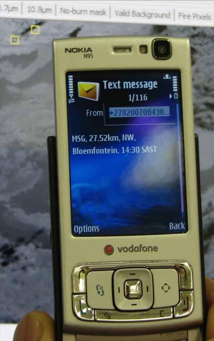
5 Advanced Fire Information System CSIR and Eskom (SA Power Utility) initiated the development of AFIS in 2004 Main aims: 1. Detection (Near real time fire detection) 2. Assessment (Burn area mapping) 3. Prediction (Fire Danger Index) Serve as a research tool as well as an alert service for fire suppression Based on multiple satellite sensors Focus on Southern Africa
6 Why ESKOM? ESKOM produces 95 % of South Africa s electricity and 70 % of Africa s Each year ESKOM experiences a substantial amount down time on its transmission lines due to wildfires. Flames, and the hot air resulting from flames can cause flash overs from line to line and from line to ground. Hot air reduces what is called the flash over potential. Flames are compared to air (even hot air) a good conductor. The flash over occurs in the form a of a lightning bolt A flash over will cause a 300 ms dip in electricity flow which can severely impact some machinery
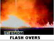
7 Impact of Flashovers
8 The Anatomy of the Power Grid TRANSMISSION LINE TRANSMISSION SUBSTATION Power station 765/400/275/220/132 kv DISTRIBUSION LINE DISTRIBUTION SUBSTASION (165/132/88/33 kv) RETIKULASIE H/S LYNE (22/11 kv) AANSLUITINGS RETIKULASIE L/S LYNE (380/220V)

9 Polar-orbiting Satellite System MODIS Satellite system Polar Orbits TERRA 10:00 14:00 AQUA Swath: Scan width: km, km resolution: 1km Overpass x 1km times: 10:00 am Overpass 14:00 pm times: 10:00 22:00 pm - Terra 14:00 02:00 am - Aqua 22:00 - Terra 02:00 1 km resolution - Aqua Fire Detection size: size: Ht Ha 50mx50m


10 Geostationary satellite Continuous observation of Africa and Europe Images every 15 minutes 4.8 Km resolution Fire size: 5 10 Ha

11 AFIS Processing Diagram CSIR SAC MSG Internet Service Provider (IS) WAMIS Server Online Mapping Service Public Cell phone Alert Service Fire Alert Services MODIS GEONETCAST Service

12 Navigation tools MSG observations MODIS observations Data layers Query data


13 SMS/ Alerts Currently National Control Grid Staff
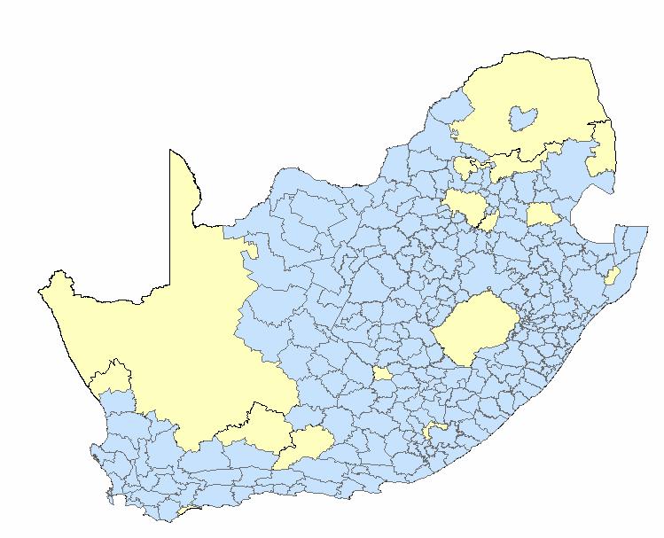
14 Fire Protection Associations on AFIS
15 Forthcoming AFIS products Operational burned area mapping Flashover Probability Index Daily FDI product based on the Lowveld model and DB CRAS forecast data Integration of 100 automated weather stations in South Africa in to AFIS for 15 minute wind speed and direction updates Dissemination of fire products via the GEONETCAST network of Eumetsat
16 Operational burned area mapping MODIS 500m burned area product (CSIR & Louis Giglio) Burned area products over Eastern South Africa MODIS tile Each pixel provides Julian date of burn (i.e. at least 4 yr data record when each pixel burned) Operational burned area product ready in next 2 weeks
17 Development of a Flashover Prediction Model A flashover prediction model has been developed to identify fires close to transmission lines with a high probability of causing a flashover The model is based on MODIS active fire product to detect fires close to power lines and numerical weather forecasts derived from the CRAS model Wind speed, Wind direction, Air temperature and Relative humidity forecasts are used to predict flashover probability

18 Flashover Probability Index (FPI)

19

20 GEONETCAST CSIR product dissimination: Daily active fires Daily FDI 16 day Burned area The FDI and burned area products will be available for Southern Africa in 2009

21 MODIS fires on National TV
GOFC/GOLD Fire IT Strategic Planning. Day 1 - Break Out Group Discussion
 GOFC/GOLD Fire IT Strategic Planning Day 1 - Break Out Group Discussion Aims of the Fire IT refining and articulating the international requirements for fire related observations making the best possible
PARALLEL USE OF SEVIRI LSA SAF FRP AND MPEF FIR PRODUCTS FOR FIRE DETECTION AND MONITORING
 PARALLEL USE OF SEVIRI LSA SAF FRP AND MPEF FIR PRODUCTS FOR FIRE DETECTION AND MONITORING C. G. Georgiev, J. S. Stoyanova National Institute of Meteorology and Hydrology, Bulgarian Academy of Sciences
Use of new spatially refined satellite remote sensing fire detection data in support of advanced wildfire mapping and modeling
 Use of new spatially refined satellite remote sensing fire detection data in support of advanced wildfire mapping and modeling Dr. Wilfrid Schroeder 1 Dr. Janice Coen 2 Dr. Patricia Oliva 1 Dr. Louis Giglio
Recent Developments and Prospects for Innovative Remote Sensing of High-Temperature Events and Vegetation Fire Impacts
 Recent Developments and Prospects for Innovative Remote Sensing of High-Temperature Events and Vegetation Fire Impacts by D. Oertel, E. Lorenz, B. Zhukov German Aerospace Center, (DLR-OS) Berlin Adlershof
Interim evaluation of the New IR Sensor Technology (NIRST) as a wildfire monitoring tool
 as a wildfire monitoring tool") Interim evaluation of the New IR Sensor Technology (NIRST) as a wildfire monitoring tool Joshua Johnston Forest Fire Analyst Canadian Forest Service Great Lakes Forestry Centre Sault Ste. Marie, Ontario
Interim evaluation of the New IR Sensor Technology (NIRST) as a wildfire monitoring tool Joshua Johnston Forest Fire Analyst Canadian Forest Service Great Lakes Forestry Centre Sault Ste. Marie, Ontario
Fire Information for Resource Management System (FIRMS)
") Fire Information for Resource Management System (FIRMS) Diane Davies 1, Chris Justice 1, Jacques Descloitres 2, John Latham 3 John Musinsky 4 1 Department of Geography, University of Maryland 2 SSAI /
Fire Information for Resource Management System (FIRMS) Diane Davies 1, Chris Justice 1, Jacques Descloitres 2, John Latham 3 John Musinsky 4 1 Department of Geography, University of Maryland 2 SSAI /
S-NPP/VIIRS and Landsat-8/OLI Global Active Fire Data Sets
 S-NPP/VIIRS and Landsat-8/OLI Global Active Fire Data Sets Wilfrid Schroeder Louis Giglio, Pierre Guillevic, William Walsh (Dept of Geographical Sciences/UMD) Janice Coen (NCAR/Boulder) Ivan Csiszar (NOAA/NESDIS/STAR)
Global Biomass Burning Emissions from a Constellation of Geostationary Satellites for Global Model Forecast Applications
 1 Global Biomass Burning Emissions from a Constellation of Geostationary Satellites for Global Model Forecast Applications Shobha Kondragunta NOAA/NESDIS Center for Satellite Applications and Research
Global fire hotspots detected by NASA satellite to help United Nations
 Global fire hotspots detected by NASA satellite to help United Nations Published on 24 Sep 2010 is Image NASA's not found Moderate or type unknown Resolution Imaging Spectroradiometer (MODIS), an instrument
[Some] Updates on Research into Fire Radiative Power & Energy
![[Some] Updates on Research into Fire Radiative Power & Energy](/thumbs/89/100768239.jpg "[Some] Updates on Research into Fire Radiative Power & Energy") Environmental Monitoring & Modelling Research Group [Some] Updates on Research into Fire Radiative Power & Energy Presented by Martin Wooster (Kings College London, UK) Slide contributions from many others
Environmental Monitoring & Modelling Research Group [Some] Updates on Research into Fire Radiative Power & Energy Presented by Martin Wooster (Kings College London, UK) Slide contributions from many others
SEVIRI/MSG sensor early fire detection performances assessment
 SEVIRI/MSG sensor early fire detection performances assessment G. Laneve, E. Cadau CRPSM Università di Roma La Sapienza e-mail: laneve@psm.uniroma1.it 2 nd GOFC/GOLD Workshop on GEO Fire Monitoring, Darmstadt,
Fire-Implementation Team (Fire-IT) Update and Future Steps
 Update and Future Steps") Global Observation of Forest and Land Cover Dynamics Fire-Implementation Team (Fire-IT) Update and Future Steps Fire-IT Co-Chair: Chris Justice (U. Maryland) Fire-IT Executive Officer: Krishna Vadrevu
Global Observation of Forest and Land Cover Dynamics Fire-Implementation Team (Fire-IT) Update and Future Steps Fire-IT Co-Chair: Chris Justice (U. Maryland) Fire-IT Executive Officer: Krishna Vadrevu
Fire Detection and Monitoring
 Fire Detection and Monitoring Akli Benali Forest Research Center, University of Lisbon aklibenali@gmail.com Conference & Summer School on Forest Fire Management Istituto Superiore Antincendi, Rome, September
The operational MSG SEVIRI fire radiative power products generated at the Land-SAF
 Environmental Monitoring & Modelling Research Group The operational MSG SEVIRI fire radiative power products generated at the Land-SAF Martin Wooster, Gareth Roberts, Weidong Xu, Patrick Freeborn, Jianping
A temporal active fire detection algorithm applied to geostationary satellite observations
 8 th 10 th June LSA-SAF Workshop 2015 A temporal active fire detection algorithm applied to geostationary satellite observations Gareth Roberts (University of Southampton) Outline Active fire detection
GOES-R AWG Land Team: Fire Detection and Characterization
 GOES-R AWG Land Team: Fire Detection and Characterization June 8, 2010 Presented By: Christopher C. Schmidt 1 1 UW-Madison/SSEC/CIMSS 1 FIRE Product Team AWG Land Team Chair: Yunyue (Bob) Yu FIRE Product
ALBERTA FOREST PROTECTION THERMAL INFRARED PROGRAM
 ALBERTA FOREST PROTECTION THERMAL INFRARED PROGRAM Eleventh Biennial USDA Forest Service Remote Sensing Applications Conference Salt Lake City, Utah April 25 Ken Dutchak, P. Biol. Reconnaissance and Remote
VIIRS FIRE PRODUCTS UPDATE
 VIIRS FIRE PRODUCTS UPDATE Ivan Csiszar 1, Wilfrid Schroeder 2, Louis Giglio 2, Brad Wind 2, Evan Ellicott 2, Christopher O. Justice 2 1 NOAA/NESDIS Center for Satellite Applications and Research, Camp
RAPID FIRE DETECTION IN MEXICO AND CENTRAL AMERICA USING REMOTE SENSING METHODS
 RAPID FIRE DETECTION IN MEXICO AND CENTRAL AMERICA Bart Wickel Gerardo Lopez Ma. Isabel Cruz Erik de Badts Raúl Jimenez Rosenberg Comisión nacional para el conocimiento y uso de la biodiversidad Organization
Elaine M. Prins* NOAA/NESDIS, Office of Research and Applications, Advanced Satellite Products Branch (ASPB) Madison, WI
 Madison, WI") P4.6 Global Geostationary Fire Monitoring System Elaine M. Prins* NOAA/NESDIS, Office of Research and Applications, Advanced Satellite Products Branch (ASPB) Madison, WI Donna McNamara NOAA/NESDIS, Office
P4.6 Global Geostationary Fire Monitoring System Elaine M. Prins* NOAA/NESDIS, Office of Research and Applications, Advanced Satellite Products Branch (ASPB) Madison, WI Donna McNamara NOAA/NESDIS, Office
Supplement of LSA SAF Meteosat FRP products Part 1: Algorithms, product contents, and analysis
 Supplement of Atmos. Chem. Phys., 15, 13217 13239, 2015 http://www.atmos-chem-phys.net/15/13217/2015/ doi:10.5194/acp-15-13217-2015-supplement Author(s) 2015. CC Attribution 3.0 License. Supplement of
Rapid Prototyping of NASA Next Generation Sensors for the SERVIR System of Fire Detection in Mesoamerica
 Rapid Prototyping of NASA Next Generation Sensors for the SERVIR System of Fire Detection in Mesoamerica Joel S. Kuszmaul, Henrique Momm, Greg Easson University of Mississippi, University, MS 38677 Timothy
Using VIIRS Direct Readout Capabilities for the Improvement of Mexico's Wild Fire Alert System
 Using VIIRS Direct Readout Capabilities for the Improvement of Mexico's Wild Fire Alert System Juan M. Escamilla Mólgora 1 National Commission for Knowledge and Use of Biodiversity CONABIO - Mexico 1 CSPP/IMAPP
16.10 Johannes Kaiser HALO Proposal
 MINUTES OF THE DISCUSSION SESSION ON WILDFIRES & BIOMASS BURNING at the GEMS Annual Assembly 2006: Monday, 6th February, 13.30-17.00 Minutes by: Christiane Textor, Johannes Kaiser, and Martin Schultz AGENDA
 www.inpe.br/queimadas This (short) presentation will stress: - Interaction with users; - GOES-16 detections A system with dozens of diferent products www.inpe.br/queimadas Our new portal CIMAN combines
Analysing Threshold Value in Fire Detection Algorithm Using MODIS Data
 RESEARCH PAPER Analysing Threshold Value in Fire Detection Algorithm Using MODIS Data 1 Bowo E. Cahyono, 2 Peter Fearns, and 3 Brendon McAtee 1 Department of Physics, Jember University, Indonesia; 2 Department
Review of MTG FDHSI Mission Requirements Regarding Fire Applications
 Review of MTG FDHSI Mission Requirements Regarding Fire Applications Dr M.J. Wooster and Dr G. Roberts Environmental Monitoring and Modelling Group, Department of Geography King s College London Document
INSTRUCTION MANUAL TRC-1490 Wireless Indoor and Outdoor Weather Station
 INSTRUCTION MANUAL TRC-1490 Wireless Indoor and Outdoor Weather Station Words in the images: Image English Other Language FRONT VIEW PM INDICATOR TIME DATE / MONTH MAXIMUM / MINIMUM ICONS LOW BATTERY OUTDOOR
Community Wildfire Safety Program. June 26, 2018
 Community Wildfire Safety Program June 26, 2018 @ WHAT'S HAPPENING. We are bolstering wildfire prevention and emergency response efforts, putting in place new and enhanced safety measures, and doing more
Building a Centre of Excellence for EO-based monitoring of Natural Disasters
 Building a Centre of Excellence for EO-based monitoring of Natural Disasters Funded under FP7-REGPOT-2012-2013-1 Activity: 4.1 Unlocking and developing the research potential of research entities established
University of Puerto Rico at Mayagüez Direct Broadcast Polar Orbiter Workshop
 University of Puerto Rico at Mayagüez Direct Broadcast Polar Orbiter Workshop 27 April 2016 Lab 2 Part 4: Investigating VIIRS and MODIS Fire Detection Capabilities 1.1. Use Hydra to open the VIIRS directory
Utilizing GPS to Increase Performance. Murray Lodge Topcon Positioning Systems
 Utilizing GPS to Increase Performance. Murray Lodge Topcon Positioning Systems Using GPS to Increase Productivity Where and how is it used? GPS on the construction jobsite Telematics Mapping Grade management
Ivan Csiszar, Martin Wooster
 Global Geostationary Network Ivan Csiszar, Martin Wooster Recommendations from 2 nd workshop Research and Product Development Continue data fusion efforts and characterization Encourage products based
DISTRIBUTION OPERATIONS AND MAINTENANCE
 EB-00-0 Tab Schedule Page of 0 DISTRIBUTION OPERATIONS AND MAINTENANCE PREDICTIVE MAINTENANCE Predictive maintenance expenditures fund work that is required to test and audit distribution system assets.
Development of a Canadian Wildland Fire Monitoring Sensor (CWFMS)
") Unclassified Development of a Canadian Wildland Fire Monitoring Sensor (CWFMS) Helena (Marleen) van Mierlo 1 Linh Ngo Phong 1 Steeve Montminy 1 Joshua M. Johnston 2 Denis Dufour 3 (1) Canadian Space Agency
Unclassified Development of a Canadian Wildland Fire Monitoring Sensor (CWFMS) Helena (Marleen) van Mierlo 1 Linh Ngo Phong 1 Steeve Montminy 1 Joshua M. Johnston 2 Denis Dufour 3 (1) Canadian Space Agency
POWER SYSTEM INCIDENT REPORT: TRIP OF DOUBLE CIRCUIT MACKAY- COLLINSVILLE TEE - PROSERPINE 132 KV LINES AND STRATHMORE SVC ON 29 DECEMBER 2010
 POWER SYSTEM INCIDENT REPORT: TRIP OF DOUBLE CIRCUIT MACKAY- COLLINSVILLE TEE - PROSERPINE 132 KV LINES AND STRATHMORE ON 29 PREPARED BY: Electricity System Operations Planning and Performance FINAL Disclaimer
3rd GWIS and GOFC-GOLD Fire IT meeting 1st-2nd October 2018, University of Maryland, Agenda v.0
 3rd GWIS and GOFC-GOLD Fire IT meeting 1st-2nd October 2018, University of Maryland, Agenda v.0 Meeting Venue Earth System Science Interdisciplinary Center (ESSIC) University of Maryland Research Park
P1.9 CHARACTERIZING AND UNDERSTANDING THE DIFFERENCES BETWEEN GOES WF_ABBA AND MODIS FIRE PRODUCTS AND IMPLICATIONS FOR DATA ASSIMILATION
 P1.9 CHARACTERIZING AND UNDERSTANDING THE DIFFERENCES BETWEEN GOES WF_ABBA AND MODIS FIRE PRODUCTS AND IMPLICATIONS FOR DATA ASSIMILATION Jay P. Hoffman 1 *, Elaine M. Prins 1, Christopher C. Schmidt 1,
GOFC-GOLD Fire An Overview
 GOFC-GOLD Fire An Overview Providing the International Coordination needed for Global Observation of Forest, Fire and Land Cover Dynamics. Krishna Prasad Vadrevu GOFC Fire Implementation Team (IT) Executive
High Resolution Display WIRELESS COLOR WEATHER STATION
 High Resolution Display WIRELESS COLOR WEATHER STATION Model: S88785 Instruction Manual DC: 070717 SIDE VIEW FRONT VIEW Outdoor Temp, humidity + Trends AC Power Jack DC 5.0V Day/Night Forecast + Trend
the EU-Japan Support Mission in the Space Sector
 Astro- und Feinwerktechnik Adlershof GmbH the EU-Japan Support Mission in the Space Sector 07 th of September 2017 Sapporo, Japan Dr.-Ing. Sebastian Scheiding s.scheiding@astrofein.com www.astrofein.com
Automated Fire and Flood Hazard Protection System
 De la Riva, J., Pérez-Cabello, F. & Chuvieco, E. (Eds) 2005 Proceedings of the 5 th International Workshop on Remote Sensing and GIS Applications to Forest Fire Management: Fire Effects Assessment: 167-172
Forest fire detection based on MODIS satellite imagery, and Comparison of NOAA satellite imagery with fire fighters' information
 Forest fire detection based on MODIS satellite imagery, and Comparison of NOAA satellite imagery with fire fighters' information *Koji Nakau, Masami Fukuda, Keiji Kushida, Hiroshi Hayasaka, Keiji Kimura,
Methods of detecting burnt area and estimating emissions Dr. Kevin Tansey
 Methods of detecting burnt area and estimating emissions Dr. Kevin Tansey (kjt7@le.ac.uk) Why fire is important Emitter of GHG and aerosols into the atmosphere Stohl, A. et al., 2006, record high air pollution
Fire Detection and Prediction Systems of
 JPTM2013, Bangkok, Thailand, 27-2929, Nov. 2013 Fire Detection and Prediction Systems of Peat-Forest t Fires in JST-JICA JSTJICA Project Toshihisa Honma, Kazuya Kaku 1, Aswin Usup 2 and 3 Agus Hidayat
Wildland Fire Air Quality Response Program
 Wildland Fire Air Quality Response Program Pete Lahm Forest Service Fire and Aviation Management Washington, D.C. 202-205-1084 // 602-432-2614 cell 661-GET-1ARA Plahm@fs.fed.us // pete.lahm@gmail.com An
WEATHER FORECASTER WITH IN/OUT THERMO RADIO-CONTROLLED COLOR PROJECTION CLOCK - Ref.: RPM OWNER S MANUAL -
 WEATHER FORECASTER WITH IN/OUT THERMO RADIO-CONTROLLED COLOR PROJECTION CLOCK - Ref.: RPM10 - - OWNER S MANUAL - Thank you for purchasing the new generation of color projection clock. Designed and engineered
Wildfire Mapping Using FireBIRD Data
 Wildfire Mapping Using FireBIRD Data Global Wildfire Information System (GWIS) GOFC GOLD Fire IT 20-23 rd November 2017, Cumberland Lodge Christian Fischer on behalf of the FireBIRD-Team German Aerospace
Synchrophasor Technology in Control Centers Clemson University, SC March 12, 2014 Vikram S. Budhraja
 Clemson University Power Systems Conference Synchrophasor Technology in Control Centers Clemson University, SC March 12, 2014 Vikram S. Budhraja Outline Synchrophasor Technology Infrastructure Lessons
Company Presentation
 Company Presentation WHERE ARE WE: STAINLESS ACCESSORIES EASTERN CAPE COMPANY BACKGROUND Stainless Design is a division of Stainless Accessories, a TS16949 accredited manufacturer of stainless steel exhaust
Enhancing our Nation s Wildfire Management Capabilities Through Application of NASA Science and Technology
 Enhancing our Nation s Wildfire Management Capabilities Through Application of NASA Science and Technology Vince Ambrosia Earth Science Division. Biospherics Branch NASA-Ames Research Center 2nd Annual
URBAN SMS Soil Management Strategy
 URBAN SMS Soil Management Strategy Baseline scenario analysis Modeling future urban sprawl in pilot cities A. Łopatka, G. Siebielec, A. Żurek, M.Głuszynska, H. van Delden & T. Stuczynski December, 2010
DEMONSTRATION OF A SEMI-OPERATIONAL FIRE RECOGNITION SERVICE USING BIRD MICRO- SATELLITE - DEMOBIRD
 DEMONSTRATION OF A SEMI-OPERATIONAL FIRE RECOGNITION SERVICE USING BIRD MICRO- SATELLITE - DEMOBIRD Jesús Gonzalo, Gonzalo Martín de Mercado Ingeniería y Servicios Aeroespaciales, S.A. (INSA), Spain Paseo
GOES-R ABI Emissive IR Bands Radiometric Performance Monitoring and Trending
 GOES-R ABI Emissive IR Bands Radiometric Performance Monitoring and Trending Haifeng Qian a, Robert Iacovazzi a, Xiangqian Wu b, Boryana Efremova a, Fangfang Yu a, Xi Shao a a ERT, Inc. Laurel, MD 20707
A Forest Fire Warning Method Based on Fire Dangerous Rating Dan Wang 1, a, Lei Xu 1, b*, Yuanyuan Zhou 1, c, Zhifu Gao 1, d
 International Conference on Applied Science and Engineering Innovation (ASEI 2015) A Forest Fire Warning Method Based on Fire Dangerous Rating Dan Wang 1, a, Lei Xu 1, b*, Yuanyuan Zhou 1, c, Zhifu Gao
Early Warning Fire Detection Engineering
 Early Warning Fire Detection Engineering Conference Presentation Author: Adrian Haenni Senior Project Manager EARL WARNING Objective Nature of an Early Warning System Structured method for a successful
Verification and Validation of OOV-TET1 Multispectral Camera Observations within the FireBIRD Project
 DLR.de Chart 1 Verification and Validation of OOV-TET1 Multispectral Camera Observations within the FireBIRD Project O. Frauenberger **, A. Börner *, E. Borg **, W Halle *, E. Lorenz *, S. Mitchell *,
Clock Radio. User manual AJ260. Register your product and get support at
 Clock Radio AJ260 Register your product and get support at www.philips.com/welcome User manual 1 1 2 3 4 5 6 7 8 # $ % ^ 9 0! @ * & 1 3 6 2 4 5 7 2 3 4 English Congratulations on your purchase, and welcome
2-inch HDCVI Speed Dome Installation Manual
 2-inch HDCVI Speed Dome Installation Manual Version 1.0.1 Table of Contents 1 INSTALLATION PREPARATION... 1 1.1 Basic Requirements... 1 1.2 Installation Check... 1 1.3 Cable Preparation... 1 1.3.1 Cable
CO 2, CH 4 and CO Observa0ons from CrIS on S-NPP and JPSS-1
 CO 2, CH 4 and CO Observa0ons from CrIS on S-NPP and JPSS-1 Xiaozhen (Shawn) Xiong 1,2, Lihang Zhou 2 Antonia Gambacorta 1,3, Nick Nalli 1,2, Changyi Tan 1,2 Flavio Iturbide-Sanchez 1,2, Kexing Zhang 1,2
WIRELESS WEATHER STATION C-8136
 C-8136 AMD C-8136 ADDD, C-8136AWD LCD-329 (US) LCD-330(EUROPE) WIRELESS WEATHER STATION C-8136 USER S INSTRUCTIONS Part NO: P17813600010 The multifunctional weather station is equipped with many functions
ForestWatch. Oregon. Click to edit Master subtitle style. KEY Features 09/05/10
 ForestWatch Oregon KEY Features Range-aware, allowing Geo-referencing from a single camera. 12 Mile + detection capability and night-detection. Smart software learns the environment, drastically reducing
ATSTORM v2. The sensor with FCES technology is connected to the interface with a communication cable.
 ATSTORM v2 ATSTORM v2 is a storm detector that measures the environmental electric field. It is fully automatic, without mobile parts, robust and highly reliable The storm detector ATSTORM v2 basic configuration
AN IOT BASED FOREST FIRE DETECTION AND PREVENTION SYSTEM USING RASPBERRY PI 3
 AN IOT BASED FOREST FIRE DETECTION AND PREVENTION SYSTEM USING RASPBERRY PI 3 RANJITH E 1, PADMABALAJI D 2, SIBISUBRAMANIAN S 3, Ms. RADHIKA S 4 1,2,3UG Scholars, Department of Computer Science and Engineering,
The Role of Satellite Observations in Assessing Impacts of Wildfire Occurrence on Respiratory Health of Population
 The Role of Satellite Observations in Assessing Impacts of Wildfire Occurrence on Respiratory Health of Population Tatiana Loboda University of Maryland Outline Wildfire and human health Interdisciplinary
Thermostat Guide Online Guide Brighten Conservation Program. Personal Reference Guide. Brighten ithermostat
 Thermostat Guide Online Guide Brighten Conservation Program Personal Reference Guide Brighten ithermostat Thermostat Guide Online Guide Brighten Conservation Program Welcome to your new Brighten ithermostat
17 TH APRIL 2017 Switch Board Monitoring Protecting Switchboard. Courtesy of ABB. Paul Lee
 17 TH APRIL Switch Board Monitoring Protecting Switchboard Courtesy of ABB. www.fengshengelectric.com.sg Paul Lee Agenda 1. Introduction 2. IEC 61439 3. Why Switchboard Monitoring 4. Switchboard Monitoring
Weather Day & Night Model: BAR339DP / BAR339DPA / BAR339DPU / BAA339DPH
 Weather Day & Night Model: BAR339DP / BAR339DPA / BAR339DPU / BAA339DPH CONTENTS USER MANUAL Overview...2 Front View...2 Back View...3 Remote Sensor...3 Getting Started...3 Main Unit Installation...3 Remote
Contents 1 Set Up 2 Gateway information 3 Operation of the App 4 Troubleshooting Description of sensors. 1 Set Up. 1.1 Connect the Gateway
 Contents 1 Set Up 2 Gateway information 3 Operation of the App 4 Troubleshooting Description of sensors 1 Set Up After downloading the Weatherhub app, follow these steps: 1.1 Connect the Gateway Connect
Catalogue Power Cables
 Catalogue Power Cables Conductores Tecnológicos S.A. www.contecsa.es Index of Cables Page Introduction 13 RV 14 RVMV 15 RVSV 16 RVFV 17 Conductores Tecnológicos S.A. 2 www.contecsa.es INTRODUCTION Power
THE NORTHSTAR SYSTEM: A NEW ERA IN EARTH OBSERVATION
 THE NORTHSTAR SYSTEM: A NEW ERA IN EARTH OBSERVATION Daniel O Connell 1, Derek R. Peddle 2, 6, Stewart Bain 3, Douglas W. Bancroft 4, Kjell Stakkestad 5,7 NorthStar, Montréal, Québec, Canada. http://www.northstar-data.com
'bregon SCIENTIFIC. Weather Day & Night Model: BAR339DP I BAR339DPA I BAR339DPU I BAA339DPH USER MANUAL
 'bregon SCIENTIFIC Weather Day & Night Model: BAR339DP I BAR339DPA I BAR339DPU I BAA339DPH USER MANUAL Weather Day & Night Model: BAR339DP I BAR339DPA I BAR339DPU I BAA339DPH CONTENTS USER MANUAL Overview...
USED ELECTIONS. 1. Lighting network
 TECHNI CALREPORT USED ELECTIONS 1. Lighting network In the premises of the building will be installed cold light with type LED floodlighters. The lighting system is designed to be made with FROR conductor
Study on paddy rice planting area and yield monitoring
 Study on paddy rice planting area and yield monitoring based on MODIS A case study of the Jianghan Plain Xin Mei 1,2, Hai Liu 3,1,2,* (1 Key Laboratory of Resources Remote Sensing and Digital Agriculture,
Steel, Civil, MEP & Telecommunication Infrastructure Service Providers MEP Profile
 Steel, Civil, MEP & Telecommunication Infrastructure Service Providers MEP Profile 1 Gulf Turrets Presence BAHRAIN QATAR U.A.E. - Dubai U.A.E. - Abu Dhabi OMAN ISO 9001:2008 ISO 14001:2004 OHSAS 18001:2007
Solar Power Project Development One week training course certified by NISE. Solar Plant Operation and Maintenance, Performance monitoring
 Solar Power Project Development One week training course certified by NISE Solar Plant Operation and Maintenance, Performance monitoring Organizers Firstgreen Consulting Pvt Ltd MNIT Jaipur Agenda Plant
BEYOND for atmospheric hazards monitoring and forecasting
 BEYOND for atmospheric hazards monitoring and forecasting V. Amiridis, S. Solomos, A. Tsekeri, E. Marinou, S. Kazadzis, E. Gerasopoulos, T. Herekakis, C. Kontoes Atmospheric hazards in BEYOND Examples
PRODUCT RANGE AUTOMATION SECURITY LIGHTING
 SECURITY SOLUTIONS ABOUT AGRI Agri-cctv Ltd provides security solutions for rural and farming communities, providing you with the tools to protect your home or business. Founded by James Anstis-Smith in
Wireless Weather Station Model: BAR826HG
 CONTENTS Wireless Weather Station Model: BAR86HG USER MANUAL Introduction... Product Overview... 3 Front View... 3 Back View... 4 Table Stand and Wall Mount... 5 Remote Sensor (RTGR38N)... 7 Getting Started...
NextGen SCADA Europe 2013
 NextGen SCADA Europe 2013 Thursday 21st & Friday 22nd March 2013 Holiday Inn Amsterdam, Netherlands Brian Tapley Manager, HV Operations, North Distribution Control Centre, Ireland 1 Presentation Overview
Overview of Federal Wildfire Remote Sensing Support 2018
 Overview of Federal Wildfire Remote Sensing Support 2018 Everett Hinkley GIO (acting) GWIS & GOFC Fire IT Meeting October 2018 Fire Season to Date* Currently Planning Level 5 Total Fires: 48,946 (10 yr
Model: C Instruction Manual DC: WIRELESS COLOR WEATHER STATION
 Model: 308-1425C Instruction Manual DC: 102314 WIRELESS COLOR WEATHER STATION FRONT VIEW Time Calendar + Alarm REMOTE SENSOR TX141TH-Bv2 Color Animated Forecast + Tendency Indoor Humidity & Temperature
PUBLICATIONS. Journal of Geophysical Research: Atmospheres
 PUBLICATIONS RESEARCH ARTICLE Key Points: We compared the 2011 HMS fire pixels to ground-based fire records in Georgia The fire detection rate increases from 3% to 80% with the increase of fire size Detection
Wildfire detection in western Canada: trends and innovations
 FINAL REPORT March 2014 Wildfire detection in western Canada: trends and innovations Ray Ault Wildfire Operations Research INTRODUCTION The Government of the rthwest Territories (GNWT) asked FPInnovations
National Infrared Operations (NIROPS) Program Overview. Tom Mellin National Infrared Program Manager
 Program Overview. Tom Mellin National Infrared Program Manager") National Infrared Operations (NIROPS) Program Overview Tom Mellin National Infrared Program Manager Topics NIROPS organization Phoenix imaging system Aircraft Data delivery to infrared interpreters IRIN
National Infrared Operations (NIROPS) Program Overview Tom Mellin National Infrared Program Manager Topics NIROPS organization Phoenix imaging system Aircraft Data delivery to infrared interpreters IRIN
I. INTRODUCTION. Index Terms Fires, satellites.
 248 IEEE JOURNAL OF SELECTED TOPICS IN APPLIED EARTH OBSERVATIONS AND REMOTE SENSING, VOL. 1, NO. 4, DECEMBER 2008 Short-Term Observations of the Temporal Development of Active Fires From Consecutive Same-Day
Model: M Instruction Manual DC: WIRELESS COLOR WEATHER STATION Mold Risk for Weather Station & Indoor Remote Sensor Location
 Model: 308-1414M Instruction Manual DC: 100814 WIRELESS COLOR WEATHER STATION Mold Risk for Weather Station & Indoor Remote Sensor Location Color Animated Forecast with Tendency (All icons shown here)
Color Forecast Station. Table of Contents
 Color Forecast Station Model: C884 Instructional Manual DC: 01816 View online setup video at: http://bit.ly/laxtechtalk Table of Contents LCD Features... Setup... Atomic Time... Set Language, Time, Date
D-Link Central Management System
 D-Link Central Management System This seamless management of digital video, audio and data is a powerful solution for large scale installations The D-Link Central Management System is a powerful system
Flexible Air-sampling Smoke Detection
 Flexible Air-sampling Smoke Detection BY Technology Pioneers in Highsensitivity Air-sampling Smoke Detection Systems Providing Solutions Beyond Traditional Smoke and Fire Detection Hochiki, a world-leader
DeltaV Operate. Product Data Sheet DeltaV Operate December 2006 Page 1. Introduction. Benefits
 December 2006 Page 1 You can easily manage your process with. Powerful operator interface, optionally up to four monitors Alarms prioritized by user Secure, standard operating desktop Intuitive graphics
SAF for Land Surface Analysis (LSA SAF)
") SAF for Land Surface Analysis (LSA SAF) VALIDATION REPORT Fire Radiative Power (LSA-502 and LSA-503) Reference Number: SAF/LAND/IM/VR_FRP/V_10 Issue/Revision Index: Issue I/2015 FRP Pixel Algorithm Version:
SAF for Land Surface Analysis (LSA SAF) VALIDATION REPORT Fire Radiative Power (LSA-502 and LSA-503) Reference Number: SAF/LAND/IM/VR_FRP/V_10 Issue/Revision Index: Issue I/2015 FRP Pixel Algorithm Version:
History and update on satellite remote sensing of fires
 History and update on satellite remote sensing of fires Chris Justice and Krishna Vadrevu Dept. Geographcial of Sciences, University of Maryland, GOFC GOLD Fire Implementation Team Fires and smoke in Indonesia
Digital Thermometer with Ice Alert and Radio-Controlled Clock. Model: RMR382 USER MANUAL CONTENTS
 Digital Thermometer with Ice Alert and Radio-Controlled Clock CONTENTS Model: RMR382 USER MANUAL Ice Warning... 7 Hi / Lo Temperature Alarm... 7 Reset... 8 Precautions... 8 Specifications... 8 About Oregon
Digital Thermometer with Ice Alert and Radio-Controlled Clock Model: RMR682
 Digital Thermometer with Ice Alert and Radio-Controlled Clock Model: RMR682 CONTENTS USER MANUAL Ice Warning... 8 Hi / Lo Temperature Alarm... 8 Reset... 8 Precautions... 8 Specifications... 9 About Oregon
I/R Thermometer Gun 12:1
 I/R Thermometer Gun 12:1 800103 INSTRUCTION MANUAL SPER SCIENTIFIC Contents Page 1. Introduction... 2 2. Safety Information... 3 3. Display And Button Locations... 4-5 4. Distance to Spot... 5 5. Measuring
Yunyong P. Utiskul, Ph.D., P.E., CFEI
 Yunyong P. Utiskul, Ph.D., P.E., CFEI Managing Engineer Thermal Sciences 17000 Science Drive, Suite 200 Bowie, MD 20715 (301) 291-2544 tel yutiskul@exponent.com Professional Profile Dr. Utiskul applies
Model: T83653v2 Instruction manual DC: WIRELESS COLOR FORECAST STATION Mold Risk for Forecast Station & Indoor Remote Sensor Location
 Model: T83653v2 Instruction manual DC: 012916 WIRELESS COLOR FORECAST STATION Mold Risk for Forecast Station & Indoor Remote Sensor Location FRONT VIEW Time, Alarm + Calendar Indoor Humidity & Temperature
The Mitigation of UHI Intensity through an Improved Land-Use Plan in the Urban Central Area: Application to Osaka City, Japan
 Academic Article Journal of Heat Island Institute International Vol.7-2 (2012) The Mitigation of UHI Intensity through an Improved Land-Use Plan in the Urban Central Area: Application to Osaka City, Japan
The FireBird mission - a scientific mission for Earth observation and hot spot detection
 The FireBird mission - a scientific mission for Earth observation and hot spot detection Terzibaschian, Thomas Reile, H., Lorenz, E. DLR, Germany 9th IAA SYMPOSIUM ON SMALL SATELLITES FOR EARTH OBSERVATION,