VIIRS FIRE PRODUCTS UPDATE
|
|
|
- Georgia Price
- 5 years ago
- Views:
Transcription


1 VIIRS FIRE PRODUCTS UPDATE Ivan Csiszar 1, Wilfrid Schroeder 2, Louis Giglio 2, Brad Wind 2, Evan Ellicott 2, Christopher O. Justice 2 1 NOAA/NESDIS Center for Satellite Applications and Research, Camp Springs, MD 2 University of Maryland, College Park, MD This work was supported by the NOAA JPSS and NASA Suomi NPP programs

 1998 1999 2000")
2 0 0.05% THE GLOBAL FIRE PRODUCT ( ) bioval.jrc.ec.europa.eu/ Fraction of GOES clear-sky observations with fire detections (JAS)
3 VIIRS Heritage: MODIS and AVHRR VIIRS MODIS Equivalent AVHRR-3 Equivalent OLS Equivalent Band Range (um) HSR (m) Band Range HSR Band Range HSR Band Range HSR DNB HRD PMT M M M M I M M I M M SAME 500 M I M a SAME 1100 M I b SAME 1100 M SAME b M M SAME 1000 M I HRD M
4 Size (km) Area (km 2 ) VIIRS Detector Aggregation Scheme MODIS ANGULAR SAMPLING Pixel Area 6 4 Cross Track 2 Along Track Scan Angle (º) JPSS program
5 MODIS and VIIRS fire detections at nadir: modeling VIIRS spatial resolution is higher that of MODIS; in general, VIIRS is expected to detect smaller fires at nadir 1000 m 750 m 90% probability of detection; boreal forest; nadir view

6 Post-launch product evaluation 24/7 script for data visualization Designed for qualitative assessment of fire data Used to identify major anomalies in data VIIRS x Aqua/MODIS intercomparison Designed for qualitative assessment of VIIRS fire detection using near-coincident Aqua/MODIS data Verify active fire product consistency on a per-pixel and/or grid basis Detailed data inspection tool Used to assess quality of individual bands and the corresponding quality flags Collection and analysis of in-situ and airborne data Explicit validation M13 SDR feedback Aggregation, low/high gain Product improvements Spatially explicit fire mask FRP VIIRS-specific algorithm changes 5/20/ :16 UTC
7 VIIRS-MODIS Comparisons The following slides will provide examples of product performance over four distinct ecosystems: Central Africa: tropical agricultural maintenance fires SE Australia: bushfires Central Asia: mid-latitude grassland and agricultural fires Siberia: boreal forest Visual expert analysis, based on MODIS experience, has been used to identify performance shortcomings Quantitative analysis of near-simultaneous VIIRS and MODIS fire counts over a spatial is performed Further examples are available at the JPSS VIIRS Active Fire Product website: 7

8 First light NPP VIIRS fire data M5-M4-M3 RGB + IDPS Active Fire ARP January 19, 2012 ~11:05 UTC
9 followed by Aqua MODIS five minutes later Band RGB + MYD14 January 19, 2012 ~11:05 UTC


10 NPP Satellite orbit tracks April 3, 2012 Aqua
 BB number of VIIRS fire pixels with overlapping Aqua/MODIS fire pixels CC number of Aqua/MODIS fire pixels (orange")
11 MODIS and VIIRS fire detections at nadir: post-launch on-orbit data VIIRS 03 April :55UTC (SE Australia) Gridded statistics: AA/BB/CC AA number of VIIRS fire pixels (red symbols) BB number of VIIRS fire pixels with overlapping Aqua/MODIS fire pixels CC number of Aqua/MODIS fire pixels (orange symbols)
 BB number of VIIRS fire pixels with overlapping Aqua/MODIS fire pixels CC number of Aqua/MODIS fire pixels (orange")
12 MODIS and VIIRS fire detections at nadir: post-launch on-orbit data MODIS 03 April :05UTC (SE Australia) Gridded statistics: AA/BB/CC AA number of VIIRS fire pixels (red symbols) BB number of VIIRS fire pixels with overlapping Aqua/MODIS fire pixels CC number of Aqua/MODIS fire pixels (orange symbols)


13 NPP Satellite orbit tracks April 13, 2012 Aqua /datacenter/orbit_tracks. html
14 NPP VIIRS Central Asia April :53 UTC M5-M4-M3 RGB + IDPS Active Fire ARP

15 Aqua MODIS Central Asia April :18 UTC Band RGB + MYD14
 BB")
16 VIIRS vs. MODIS Central Asia April VIIRS/overlap/MODIS Gridded statistics: AA/BB/CC AA number of VIIRS fire pixels (red symbols) BB number of VIIRS fire pixels with overlapping Aqua/MODIS fire pixels CC number of Aqua/MODIS fire pixels (orange symbols)
17 NPP Satellite orbit tracks June 16, 2012 Aqua /datacenter/orbit_tracks. html

18 NPP VIIRS Western Siberia June :15 UTC M5-M4-M3 RGB + IDPS Active Fire ARP

19 Aqua MODIS Western Siberia June :42 UTC Band RGB + MYD14
")
20 VIIRS vs. MODIS Western Siberia April VIIRS/overlap/MODIS Gridded statistics: AA/BB/CC AA number of VIIRS fire pixels (red symbols) BB number of VIIRS fire pixels with overlapping Aqua/MODIS fire pixels CC number of Aqua/MODIS fire pixels (orange symbols)
 2.0 1.5 1.0 0.5 Along Track Cross Track_Aggr Cross Track_Unaggr Pixel Area_Aggr 3.0 2.5 2.0 1.5 1.0 0.5 Area (km 2 ) M13 Data Aggregation Bug Identified (Feb 2012) 0.")
21 Size (km) Size (km) Area (km 2 ) Aqua MODIS vs. Suomi NPP VIIRS 12 MODIS angular sampling 10 Pixel Area 8 6 Cross Track 4 2 Along Track Scan Angle (º) Along Track Cross Track_Aggr Cross Track_Unaggr Pixel Area_Aggr Area (km 2 ) M13 Data Aggregation Bug Identified (Feb 2012) Compatible orbital segments are determined by pixel sizes VIIRSxMYD14 Fire Detection Frequency (19 Jan <> 13 Feb)
22 Size (km) Size (km) Area (km 2 ) Aqua MODIS vs. Suomi NPP VIIRS 12 MODIS angular sampling 10 Pixel Area 8 6 Cross Track 4 2 Along Track Scan Angle (º) Along Track Cross Track_Aggr Cross Track_Unaggr Pixel Area_Aggr Area (km 2 ) M13 Data Aggregation Revised in Mx5.3 (May 2012) Compatible orbital segments are determined by pixel sizes VIIRSxMYD14 Fire Detection Frequency (11 May <> 10 Jun)


23 Spurious fire detections 7/9/ :11 UTC N N 03/01 / :43 UTC 03/14 / :58 UTC 23

24 One step further: use of VIIRS I bands NPP VIIRS M-band fire mask: Western Siberia June :15 UTC

25 One step further: use of VIIRS I bands NPP VIIRS I-band fire mask: Western Siberia June :15 UTC County Line Fire, Florida April 11th 2012 NPP/VIIRS 375 m Preliminary fire detection data (red vector outline)
26 Fire characterization from S-NPP VIIRS M13 saturation temperature: 634K very small percentage of fires to trigger saturation Fire Radiative Power retrieval is possible M15 saturation temperature: 363K small, but non-negligible percentage of fires triggers saturation of native resolution pixels more complex characterization (i.e. smoldering ratio) be compromised Fire Radiative Power to be included in VIIRS active fire product now a requirement for J1 and beyond
27 VIIRS active fire product development NOAA: real-time NOAA operational applications Operational product generated by IDPS (Interface Data Processing Segment) Part of integrated processing chain Low latency Detections only Locations only (no fire mask) VIIRS Fire Team Algorithm updates Upstream processing updates NASA: science, long-term continuity + added value NRT Experimental MODIS continuity product a at the Land PEATE (Product Evaluation and Test Element) Detections, Fire Mask and Fire Radiative Power, CMG Spatially explicit fire mask Spatial and temporal aggregates heritage deliver systems (RR, FIRMS) algorithm synchronization, end user feedback DIRECT READOUT Can run IDPS, NASA or locally developed code Stand-alone
28 Replacement algorithm (MODIS C6) MODIS V6 code running on VIIRS data at LCF and in LandPEATE Spatially explicit fire mask and FRP - > new JPSS L1 Requirements Supplement Additional data layers for CMG Ocean processing for gas flares, a new false-alarm rejection test over tropical regions, and dynamic potential fire thresholds

29 IDPS algorithm (MODIS C4) MODIS Version 4 algorithm running on VIIRS data Sparse array of fire pixels no spatially explicit fire mask No FRP Land-only processing
 and Berlin Infrared Optical System (BIROS) Use I-band to validate M-band Coincident acquisition from MODIS")
30 Airborne USDA Forest Service, NASA Validation: remote sensing data Active Fire Area Fire Radiative Power 18 Oct ha Rx fire at Henry Coe State Park/CA Aerial coverage provided by NASA/Ames AMS airborne m resolution Spaceborne DLR: Technology Experimental Probe (TET-1) and Berlin Infrared Optical System (BIROS) Use I-band to validate M-band Coincident acquisition from MODIS (Terra and Aqua) and GOES East/West

 State agencies")
 International community 2.")
31 Validation: in-situ data Ground Verification qualitative assessment Use of coincident prescribed burns to verify active fire detection data using both I and M bands Engaging: Individuals (private land owners) State agencies (fire/forestry departments) Federal agencies (USDA Forest Service) International community 2.2 ha grassland fire in Chestertown, MD 23 March 2012

32 Validation Activities: in-situ data Ground Verification qualitative assessment Use of coincident prescribed burns to verify active fire detection data using both I and M bands Fire information provided by USDA personnel Date and location of burn Area burned Fuel load & fuel consumption Confirmed VIIRS active fire pixels

33 VIIRS Active Fire Product Website viirsfire.geog.umd.edu

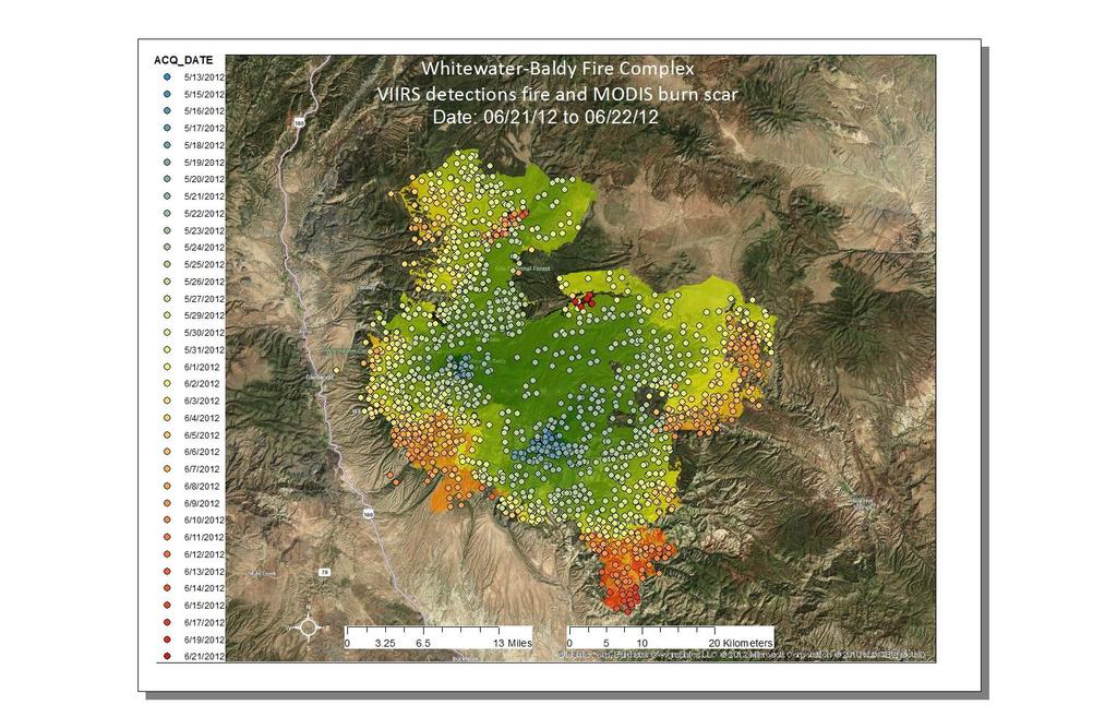
34 courtesy Rob Balfour Whitewater-Baldy Fire Progression Map
35 NIFC
36 Options: VIIRS fire data access NOAA CLASS Web NASA LAADSWeb ladsweb.nascom.nasa.gov/data/search.html NOAA CLASS ftp (anonymous) ftp-npp.class.ngcd.noaa.gov NASA LAADS ftp (anonymous) ladsweb.nascom.nasa.gov Detailed instructions: viirsfire.geog.umd.edu/documents/viirs_data_tutorial.pdf
 No Yes (HDF5 only) Order HDF5 Order HDF4 NOAA CLASS FTP LAADS FTP \"/alldata/3000\" LAADS FTP")
37 VIIRS fire data access options Order Spatial Subsets* No Yes Order Daily Bundles NOAA CLASS URL (HDF5 only) LAADSWeb URL (HDF4 & 5) No Yes (HDF5 only) Order HDF5 Order HDF4 NOAA CLASS FTP LAADS FTP "/alldata/3000" LAADS FTP "/alldata/3001"

38 SNPP EDR PRODUCT MATURITY DEFINITIONS CLASS WILL START DISTRIBUTION OF PRODUCTS WHEN THEY REACH BETA MATURITY LEVEL maturity level.html JPSS program

39 NOAA SUOMI NPP DATA ACCESS: CLASS NPP products will be released to the user community over a time frame of several months. As products become available please go to the Suomi NPP FAQ to determine which products can be ordered. All newly released products will be 'beta'. Please see Product Maturity Level page to determine level of quality for each product. Frequently asked questions (FAQ) Product Maturity Levels Tutorial on Data Access
40 Online articles First Fire Images from VIIRS (January 26, 2012) NASA/NOAA Satellite Sees Western U.S. High Mountain Blazes (July 13, 2012) NASA Finalizes Contracts for NOAA's JPSS-1 Mission (August 10, 2012) Complex Interactions between Wildfires and Lightning during Summer 2012 (December 12, 2012 by Scott Rudloski)
41 Challenges Product Latency for some users Early fire detection is critical CLASS latency is insufficient for NRT applications default latency is 6 hours DB processing is one possible solution at local scales need also direct access to IDPS output for non-db users and for development / demonstration purposes (2 hour latency) Algorithm Improvements Algorithm validation and development are still ongoing IDPS algorithm prior to Mx6.3 produced spurious scan-lines Provision > Validation (L1, L2, L3) MODIS as references serves as initial evaluation source for consistency (i.e. expected relative performance due to sensor differences) Collection of truth reference data is costly and logistically difficult Airborne high resolution radiometers In-situ data (mainly from field campaigns) Reference satellite data (e.g. DLR German Space Agency TET / BIROS missions) Science and applications Algorithm and product suitability, continuity, long-term monitoring, reprocessing
42 Summary and Conclusions Early assessment of the SNPP VIIRS fire product is encouraging Suomi NPP fire product is currently in the Intensive Calibration and Validation phase Active Fires product has been declared Beta maturity and is publicly available Ready for user evaluation User Readiness and Proving Ground activities are reaching out various domestic and international end users - goal is the continuity and enhancement of the MODIS product suite LANCE, RR, FIRMS Implementation of DB processing systems is underway domestically and internationally Continuing coordination regarding product evaluation and algorithm versioning is critical More work is needed to implement new MODIS algorithm components (C6) and sensor-specific tuning in the VIIRS product, product content and product suite Use of I band - DNB data (detection, validation, fused products) Validation of global product remains crucial and will be challenging
Satellite Derived Fire Products for Biomass Burning Studies
 Satellite Derived Fire Products for Biomass Burning Studies Chris Justice University of Maryland and colleagues Fires in Indochina April 6 2010 ( NASA MODIS Aqua) THE GLOBAL FIRE PRODUCT (1992 93) bioval.jrc.ec.europa.eu/
S-NPP/VIIRS and Landsat-8/OLI Global Active Fire Data Sets
 S-NPP/VIIRS and Landsat-8/OLI Global Active Fire Data Sets Wilfrid Schroeder Louis Giglio, Pierre Guillevic, William Walsh (Dept of Geographical Sciences/UMD) Janice Coen (NCAR/Boulder) Ivan Csiszar (NOAA/NESDIS/STAR)
Use of new spatially refined satellite remote sensing fire detection data in support of advanced wildfire mapping and modeling
 Use of new spatially refined satellite remote sensing fire detection data in support of advanced wildfire mapping and modeling Dr. Wilfrid Schroeder 1 Dr. Janice Coen 2 Dr. Patricia Oliva 1 Dr. Louis Giglio
GOFC/GOLD Fire IT Strategic Planning. Day 1 - Break Out Group Discussion
 GOFC/GOLD Fire IT Strategic Planning Day 1 - Break Out Group Discussion Aims of the Fire IT refining and articulating the international requirements for fire related observations making the best possible
GOES-R AWG Land Team: Fire Detection and Characterization
 GOES-R AWG Land Team: Fire Detection and Characterization June 8, 2010 Presented By: Christopher C. Schmidt 1 1 UW-Madison/SSEC/CIMSS 1 FIRE Product Team AWG Land Team Chair: Yunyue (Bob) Yu FIRE Product
Recent Developments and Prospects for Innovative Remote Sensing of High-Temperature Events and Vegetation Fire Impacts
 Recent Developments and Prospects for Innovative Remote Sensing of High-Temperature Events and Vegetation Fire Impacts by D. Oertel, E. Lorenz, B. Zhukov German Aerospace Center, (DLR-OS) Berlin Adlershof
Global Biomass Burning Emissions from a Constellation of Geostationary Satellites for Global Model Forecast Applications
 1 Global Biomass Burning Emissions from a Constellation of Geostationary Satellites for Global Model Forecast Applications Shobha Kondragunta NOAA/NESDIS Center for Satellite Applications and Research
 www.inpe.br/queimadas This (short) presentation will stress: - Interaction with users; - GOES-16 detections A system with dozens of diferent products www.inpe.br/queimadas Our new portal CIMAN combines
Development of a Canadian Wildland Fire Monitoring Sensor (CWFMS)
") Unclassified Development of a Canadian Wildland Fire Monitoring Sensor (CWFMS) Helena (Marleen) van Mierlo 1 Linh Ngo Phong 1 Steeve Montminy 1 Joshua M. Johnston 2 Denis Dufour 3 (1) Canadian Space Agency
Unclassified Development of a Canadian Wildland Fire Monitoring Sensor (CWFMS) Helena (Marleen) van Mierlo 1 Linh Ngo Phong 1 Steeve Montminy 1 Joshua M. Johnston 2 Denis Dufour 3 (1) Canadian Space Agency
Interim evaluation of the New IR Sensor Technology (NIRST) as a wildfire monitoring tool
 as a wildfire monitoring tool") Interim evaluation of the New IR Sensor Technology (NIRST) as a wildfire monitoring tool Joshua Johnston Forest Fire Analyst Canadian Forest Service Great Lakes Forestry Centre Sault Ste. Marie, Ontario
Interim evaluation of the New IR Sensor Technology (NIRST) as a wildfire monitoring tool Joshua Johnston Forest Fire Analyst Canadian Forest Service Great Lakes Forestry Centre Sault Ste. Marie, Ontario
Verification and Validation of OOV-TET1 Multispectral Camera Observations within the FireBIRD Project
 DLR.de Chart 1 Verification and Validation of OOV-TET1 Multispectral Camera Observations within the FireBIRD Project O. Frauenberger **, A. Börner *, E. Borg **, W Halle *, E. Lorenz *, S. Mitchell *,
There are various resources and toolkits available to perform this task.
 Hands-On Exercise: Wildfires in Chile, January 2017 Task description Imagine you are analyst that has been assigned to the fire Las Maquinas burning in the vicinity of Constitución, in the Maule region
Wildfire Mapping Using FireBIRD Data
 Wildfire Mapping Using FireBIRD Data Global Wildfire Information System (GWIS) GOFC GOLD Fire IT 20-23 rd November 2017, Cumberland Lodge Christian Fischer on behalf of the FireBIRD-Team German Aerospace
DETECTION AND MONITORING OF ACTIVE FIRES USING REMOTE SENSING TECHNIQUES
 DETECTION AND MONITORING OF ACTIVE FIRES USING REMOTE SENSING TECHNIQUES Source: Unknown n.d., http://www.hotrodsandclassics.net/featuredpictures/featurepictures2.htm. by Claire Riddell DETECTION AND MONITORING
Fire-Implementation Team (Fire-IT) Update and Future Steps
 Update and Future Steps") Global Observation of Forest and Land Cover Dynamics Fire-Implementation Team (Fire-IT) Update and Future Steps Fire-IT Co-Chair: Chris Justice (U. Maryland) Fire-IT Executive Officer: Krishna Vadrevu
Global Observation of Forest and Land Cover Dynamics Fire-Implementation Team (Fire-IT) Update and Future Steps Fire-IT Co-Chair: Chris Justice (U. Maryland) Fire-IT Executive Officer: Krishna Vadrevu
I. INTRODUCTION. Index Terms Fires, satellites.
 248 IEEE JOURNAL OF SELECTED TOPICS IN APPLIED EARTH OBSERVATIONS AND REMOTE SENSING, VOL. 1, NO. 4, DECEMBER 2008 Short-Term Observations of the Temporal Development of Active Fires From Consecutive Same-Day
A temporal active fire detection algorithm applied to geostationary satellite observations
 8 th 10 th June LSA-SAF Workshop 2015 A temporal active fire detection algorithm applied to geostationary satellite observations Gareth Roberts (University of Southampton) Outline Active fire detection
University of Puerto Rico at Mayagüez Direct Broadcast Polar Orbiter Workshop
 University of Puerto Rico at Mayagüez Direct Broadcast Polar Orbiter Workshop 27 April 2016 Lab 2 Part 4: Investigating VIIRS and MODIS Fire Detection Capabilities 1.1. Use Hydra to open the VIIRS directory
SEVIRI/MSG sensor early fire detection performances assessment
 SEVIRI/MSG sensor early fire detection performances assessment G. Laneve, E. Cadau CRPSM Università di Roma La Sapienza e-mail: laneve@psm.uniroma1.it 2 nd GOFC/GOLD Workshop on GEO Fire Monitoring, Darmstadt,
Results on verification and validation of OOV-TET1 multispectral camera observations within the FireBIRD project
 Results on verification and validation of OOV-TET1 multispectral camera observations within the FireBIRD project O. Frauenberger **, E. Borg **, A. Börner *, W Halle *, E. Lorenz *, S. Mitchell *, C. Paproth
[Some] Updates on Research into Fire Radiative Power & Energy
![[Some] Updates on Research into Fire Radiative Power & Energy](/thumbs/89/100768239.jpg "[Some] Updates on Research into Fire Radiative Power & Energy") Environmental Monitoring & Modelling Research Group [Some] Updates on Research into Fire Radiative Power & Energy Presented by Martin Wooster (Kings College London, UK) Slide contributions from many others
Environmental Monitoring & Modelling Research Group [Some] Updates on Research into Fire Radiative Power & Energy Presented by Martin Wooster (Kings College London, UK) Slide contributions from many others
CO 2, CH 4 and CO Observa0ons from CrIS on S-NPP and JPSS-1
 CO 2, CH 4 and CO Observa0ons from CrIS on S-NPP and JPSS-1 Xiaozhen (Shawn) Xiong 1,2, Lihang Zhou 2 Antonia Gambacorta 1,3, Nick Nalli 1,2, Changyi Tan 1,2 Flavio Iturbide-Sanchez 1,2, Kexing Zhang 1,2
GOES-R ABI Emissive IR Bands Radiometric Performance Monitoring and Trending
 GOES-R ABI Emissive IR Bands Radiometric Performance Monitoring and Trending Haifeng Qian a, Robert Iacovazzi a, Xiangqian Wu b, Boryana Efremova a, Fangfang Yu a, Xi Shao a a ERT, Inc. Laurel, MD 20707
Long-term Inventory of Fire Burned Areas and Emissions of North America s Boreal and Temperate Forests
 Long-term Inventory of Fire Burned Areas and Emissions of North America s Boreal and Temperate Forests P.Gong, Z. Li, I. Csiszar, W. Hao, R. Fraser J.Z. Jin, R. Pu Objectives 1. Map burn scars in boreal
Elaine M. Prins* NOAA/NESDIS, Office of Research and Applications, Advanced Satellite Products Branch (ASPB) Madison, WI
 Madison, WI") P4.6 Global Geostationary Fire Monitoring System Elaine M. Prins* NOAA/NESDIS, Office of Research and Applications, Advanced Satellite Products Branch (ASPB) Madison, WI Donna McNamara NOAA/NESDIS, Office
P4.6 Global Geostationary Fire Monitoring System Elaine M. Prins* NOAA/NESDIS, Office of Research and Applications, Advanced Satellite Products Branch (ASPB) Madison, WI Donna McNamara NOAA/NESDIS, Office
Using VIIRS Direct Readout Capabilities for the Improvement of Mexico's Wild Fire Alert System
 Using VIIRS Direct Readout Capabilities for the Improvement of Mexico's Wild Fire Alert System Juan M. Escamilla Mólgora 1 National Commission for Knowledge and Use of Biodiversity CONABIO - Mexico 1 CSPP/IMAPP
DEMONSTRATION OF A SEMI-OPERATIONAL FIRE RECOGNITION SERVICE USING BIRD MICRO- SATELLITE - DEMOBIRD
 DEMONSTRATION OF A SEMI-OPERATIONAL FIRE RECOGNITION SERVICE USING BIRD MICRO- SATELLITE - DEMOBIRD Jesús Gonzalo, Gonzalo Martín de Mercado Ingeniería y Servicios Aeroespaciales, S.A. (INSA), Spain Paseo
PARALLEL USE OF SEVIRI LSA SAF FRP AND MPEF FIR PRODUCTS FOR FIRE DETECTION AND MONITORING
 PARALLEL USE OF SEVIRI LSA SAF FRP AND MPEF FIR PRODUCTS FOR FIRE DETECTION AND MONITORING C. G. Georgiev, J. S. Stoyanova National Institute of Meteorology and Hydrology, Bulgarian Academy of Sciences
History and update on satellite remote sensing of fires
 History and update on satellite remote sensing of fires Chris Justice and Krishna Vadrevu Dept. Geographcial of Sciences, University of Maryland, GOFC GOLD Fire Implementation Team Fires and smoke in Indonesia
Rapid Prototyping of NASA Next Generation Sensors for the SERVIR System of Fire Detection in Mesoamerica
 Rapid Prototyping of NASA Next Generation Sensors for the SERVIR System of Fire Detection in Mesoamerica Joel S. Kuszmaul, Henrique Momm, Greg Easson University of Mississippi, University, MS 38677 Timothy
Global fire hotspots detected by NASA satellite to help United Nations
 Global fire hotspots detected by NASA satellite to help United Nations Published on 24 Sep 2010 is Image NASA's not found Moderate or type unknown Resolution Imaging Spectroradiometer (MODIS), an instrument
Supplement of LSA SAF Meteosat FRP products Part 1: Algorithms, product contents, and analysis
 Supplement of Atmos. Chem. Phys., 15, 13217 13239, 2015 http://www.atmos-chem-phys.net/15/13217/2015/ doi:10.5194/acp-15-13217-2015-supplement Author(s) 2015. CC Attribution 3.0 License. Supplement of
P1.9 CHARACTERIZING AND UNDERSTANDING THE DIFFERENCES BETWEEN GOES WF_ABBA AND MODIS FIRE PRODUCTS AND IMPLICATIONS FOR DATA ASSIMILATION
 P1.9 CHARACTERIZING AND UNDERSTANDING THE DIFFERENCES BETWEEN GOES WF_ABBA AND MODIS FIRE PRODUCTS AND IMPLICATIONS FOR DATA ASSIMILATION Jay P. Hoffman 1 *, Elaine M. Prins 1, Christopher C. Schmidt 1,
Advanced Fire Information System
 Advanced Fire Information System Karen Steenkamp Philip Frost CSIR Meraka Institute www.sac.co.za Meraka Institute - RSRU RSRU Mission: To conduct basic and applied remote sensing research for the advancement
Detection and analysis of high-temperature events in the BIRD mission
 Acta Astronautica 56 (2005) 65 71 www.elsevier.com/locate/actaastro Detection and analysis of high-temperature events in the BIRD mission Boris Zhukov, Klaus Briess, Eckehard Lorenz, Dieter Oertel, Wolfgang
National Infrared Operations (NIROPS) Program Overview. Tom Mellin National Infrared Program Manager
 Program Overview. Tom Mellin National Infrared Program Manager") National Infrared Operations (NIROPS) Program Overview Tom Mellin National Infrared Program Manager Topics NIROPS organization Phoenix imaging system Aircraft Data delivery to infrared interpreters IRIN
National Infrared Operations (NIROPS) Program Overview Tom Mellin National Infrared Program Manager Topics NIROPS organization Phoenix imaging system Aircraft Data delivery to infrared interpreters IRIN
The FireBird mission - a scientific mission for Earth observation and hot spot detection
 The FireBird mission - a scientific mission for Earth observation and hot spot detection Terzibaschian, Thomas Reile, H., Lorenz, E. DLR, Germany 9th IAA SYMPOSIUM ON SMALL SATELLITES FOR EARTH OBSERVATION,
Daytime Fire Detection Using Airborne Hyperspectral Data Philip E. Dennison 1 and Dar A. Roberts 2. University of Utah, Salt Lake City, UT 84112, USA
 Daytime Fire Detection Using Airborne Hyperspectral Data Philip E. Dennison 1 and Dar A. Roberts 2 1 Department of Geography and Center for Natural and Technological Hazards, University of Utah, Salt Lake
Evaluation of remote sensing-based active fire datasets in Indonesia
 INT. J. REMOTE SENSING, 20JANUARY, 2004, VOL. 25, NO. 2, 471 479 Evaluation of remote sensing-based active fire datasets in Indonesia F. STOLLE*{, R. A. DENNIS{, I. KURNIWAN{ and E. F. LAMBIN {Global Forest
ALBERTA FOREST PROTECTION THERMAL INFRARED PROGRAM
 ALBERTA FOREST PROTECTION THERMAL INFRARED PROGRAM Eleventh Biennial USDA Forest Service Remote Sensing Applications Conference Salt Lake City, Utah April 25 Ken Dutchak, P. Biol. Reconnaissance and Remote
Fire Information for Resource Management System (FIRMS)
") Fire Information for Resource Management System (FIRMS) Diane Davies 1, Chris Justice 1, Jacques Descloitres 2, John Latham 3 John Musinsky 4 1 Department of Geography, University of Maryland 2 SSAI /
Fire Information for Resource Management System (FIRMS) Diane Davies 1, Chris Justice 1, Jacques Descloitres 2, John Latham 3 John Musinsky 4 1 Department of Geography, University of Maryland 2 SSAI /
RAPID FIRE DETECTION IN MEXICO AND CENTRAL AMERICA USING REMOTE SENSING METHODS
 RAPID FIRE DETECTION IN MEXICO AND CENTRAL AMERICA Bart Wickel Gerardo Lopez Ma. Isabel Cruz Erik de Badts Raúl Jimenez Rosenberg Comisión nacional para el conocimiento y uso de la biodiversidad Organization
The operational MSG SEVIRI fire radiative power products generated at the Land-SAF
 Environmental Monitoring & Modelling Research Group The operational MSG SEVIRI fire radiative power products generated at the Land-SAF Martin Wooster, Gareth Roberts, Weidong Xu, Patrick Freeborn, Jianping
Forest fire detection based on MODIS satellite imagery, and Comparison of NOAA satellite imagery with fire fighters' information
 Forest fire detection based on MODIS satellite imagery, and Comparison of NOAA satellite imagery with fire fighters' information *Koji Nakau, Masami Fukuda, Keiji Kushida, Hiroshi Hayasaka, Keiji Kimura,
DEVELOPMENT OF THE INFRARED INSTRUMENT FOR GAS DETECTION
 DEVELOPMENT OF THE INFRARED INSTRUMENT FOR GAS DETECTION Ching-Wei Chen 1, Chia-Ray Chen 1 1 National Space Organization, National Applied Research Laboratories ABSTRACT MWIR (Mid-Wave Infrared) spectroscopy
Overview of the WF_ABBA Global Geostationary Fire Monitoring Program: Current Implementation and Future Plans
 Overview of the WF_ABBA Global Geostationary Fire Monitoring Program: Current Implementation and Future Plans Elaine M. Prins Consultant Christopher C. Schmidt Jay Hoffman Jason Brunner UW-Madison SSEC
Fire Detection and Monitoring
 Fire Detection and Monitoring Akli Benali Forest Research Center, University of Lisbon aklibenali@gmail.com Conference & Summer School on Forest Fire Management Istituto Superiore Antincendi, Rome, September
Wildland fire phenomenology experiments:
 Wildland fire phenomenology experiments: 2001-2002 RIT: Bob Kremens Stef VanGorden Andy Fordham Bryce Nordgren Dave Pogolarza Adam Cisz RMSC: Dan Latham Colin Hardy Brett Butler We plan to measure unknown
the EU-Japan Support Mission in the Space Sector
 Astro- und Feinwerktechnik Adlershof GmbH the EU-Japan Support Mission in the Space Sector 07 th of September 2017 Sapporo, Japan Dr.-Ing. Sebastian Scheiding s.scheiding@astrofein.com www.astrofein.com
Physical concepts. Remote sensing of fires and vegetation. Applications of SEVIRI channels.
 Physical concepts Remote sensing of fires and vegetation Applications of SEVIRI channels jose.prieto@eumetsat.int Contents Applications of SEVIRI channels Characteristics of the 3.9µm channel Differences
Sentinel Asia Wildfire Monitoring
 Sentinel Asia Wildfire Monitoring Masami FUKUDA Institute of Low Temp. Sci. Hokkaido Univ. 3rd Sentinel Asia JPT Meeting 13 March 2007, Singapore Objective of Sentinel Asia Wildfire Monitoring Contribution
Review of MTG FDHSI Mission Requirements Regarding Fire Applications
 Review of MTG FDHSI Mission Requirements Regarding Fire Applications Dr M.J. Wooster and Dr G. Roberts Environmental Monitoring and Modelling Group, Department of Geography King s College London Document
Analysing Threshold Value in Fire Detection Algorithm Using MODIS Data
 RESEARCH PAPER Analysing Threshold Value in Fire Detection Algorithm Using MODIS Data 1 Bowo E. Cahyono, 2 Peter Fearns, and 3 Brendon McAtee 1 Department of Physics, Jember University, Indonesia; 2 Department
Validation of MODIS Active Fire Detection Products Derived from Two Algorithms
 Earth Interactions Volume 9 (2005) Paper No. 9 Page 1 Copyright 2005, Paper 09-009; 7,505 words, 11 Figures, 0 Animations, 2 Tables. http://earthinteractions.org Validation of MODIS Active Fire Detection
USDA Forest Service Fire Remote Sensing Program Update. Everett Hinkley/Brad Quayle
 USDA Forest Service Fire Remote Sensing Program Update Global Observation of Forest and Land Cover Dynamics Fire Mapping and Monitoring Implementation Team Meeting July 29 31, 2014 Everett Hinkley/Brad
The Compact Muon Solenoid Experiment. Conference Report. Mailing address: CMS CERN, CH-1211 GENEVA 23, Switzerland
 Available on CMS information server CMS CR -2016/298 The Compact Muon Solenoid Experiment Conference Report Mailing address: CMS CERN, CH-1211 GENEVA 23, Switzerland 28 October 2016 (v2, 25 November 2016)
Enhancing our Nation s Wildfire Management Capabilities Through Application of NASA Science and Technology
 Enhancing our Nation s Wildfire Management Capabilities Through Application of NASA Science and Technology Vince Ambrosia Earth Science Division. Biospherics Branch NASA-Ames Research Center 2nd Annual
Product data sheet Palas Fidas 200 S
 Product data sheet Palas Fidas 200 S Applications Regulatory environmental monitoring in measuring networks Ambient air measurement campaigns Oriented indicative measurements (spot checks) Long-term studies
Sentinel Asia. Disaster Management Support System. Wild Fire Working Group
 Sentinel Asia Disaster Management Support System Wild Fire Working Group Impact to future global warming Carbon Cycle Sink Source Contribution to Kyoto Protocol Sustainable Forest Management Reports on
The new generation Teledyne NIR detectors for the SNAP/JDEM mission spectrograph.
 The new generation Teledyne NIR detectors for the SNAP/JDEM mission spectrograph. 1 Outline The SNAP/JDEM mission The SNAP/JDEM spectrograph and the IR spectrograph detector requirements R&D program for
The Role of Satellite Observations in Assessing Impacts of Wildfire Occurrence on Respiratory Health of Population
 The Role of Satellite Observations in Assessing Impacts of Wildfire Occurrence on Respiratory Health of Population Tatiana Loboda University of Maryland Outline Wildfire and human health Interdisciplinary
Validating the TET-1 satellite sensing system in detecting and characterizing active fire hotspots
 Validating the TET-1 satellite sensing system in detecting and characterizing active fire hotspots A thesis submitted in fulfilment of the requirements for the degree of Master of Science Simon Stuart
Curriculum Vitae. Signature Date 2/15/2018
 Curriculum Vitae Notarization. I have read the following and certify that this curriculum vitae is a current and accurate statement of my professional record. Signature Date 2/15/2018 In general, do not
TSI AEROTRAK PORTABLE PARTICLE COUNTER MODEL 9110
 TSI AEROTRAK PORTABLE PARTICLE COUNTER MODEL 9110 APPLICATION NOTE CC-107 Introduction This purpose of this document is to detail the advanced, state of the art features TSI has incorporated in the design
Real Time Pipeline Leak Detection on Shell s North Western Ethylene Pipeline
 Real Time Pipeline Leak Detection on Shell s North Western Ethylene Pipeline Dr Jun Zhang & Dr Ling Xu* REL Instrumentation Limited ABSTRACT In the past ten years, a number of pipeline leak detection systems
Fire Detection and Prediction Systems of
 JPTM2013, Bangkok, Thailand, 27-2929, Nov. 2013 Fire Detection and Prediction Systems of Peat-Forest t Fires in JST-JICA JSTJICA Project Toshihisa Honma, Kazuya Kaku 1, Aswin Usup 2 and 3 Agus Hidayat
Curriculum Vitae. Signature Date 1/11/2019
 Curriculum Vitae Notarization. I have read the following and certify that this curriculum vitae is a current and accurate statement of my professional record. Signature Date 1/11/2019 In general, do not
Soil Moisture Data Assimilation in Process Based Models
 Soil Moisture Data Assimilation in Process Based Models Wade Crow, Rolf Reichle, John Bolten, and Iva Mladenova Emerging Technologies and Methods in Earth Observation for Agricultural Monitoring February
Ivan Csiszar, Martin Wooster
 Global Geostationary Network Ivan Csiszar, Martin Wooster Recommendations from 2 nd workshop Research and Product Development Continue data fusion efforts and characterization Encourage products based
RLDS - Remote LEAK DETECTION SYSTEM
 RLDS - Remote LEAK DETECTION SYSTEM Asel-Tech has spent considerable time and resources over the past 8 years to improve our technology, to the point where it is unparalleled in reliability and performance
3rd GWIS and GOFC-GOLD Fire IT meeting 1st-2nd October 2018, University of Maryland, Agenda v.0
 3rd GWIS and GOFC-GOLD Fire IT meeting 1st-2nd October 2018, University of Maryland, Agenda v.0 Meeting Venue Earth System Science Interdisciplinary Center (ESSIC) University of Maryland Research Park
PUBLICATIONS. Journal of Geophysical Research: Atmospheres
 PUBLICATIONS RESEARCH ARTICLE Key Points: We compared the 2011 HMS fire pixels to ground-based fire records in Georgia The fire detection rate increases from 3% to 80% with the increase of fire size Detection
Passive Standoff FTIR Detectors as Transducers. Background From radiation to information
 Slide 1 of 27 Passive Standoff Fourier-Transform Infrared Detectors as Transducers Richard J. Green, PhD, Advanced Technology Branch, West Desert Test Center, Dugway Proving Ground, UT 84022 Slide 2 of
DFPC s Toolbox. Colorado Fire Prediction System (CO-FPS)
") DFPC s Toolbox Colorado Fire Prediction System (CO-FPS) Wildfire in Colorado 68% of Colorado s forested lands are under federal jurisdiction The Wildland-Urban Interface in Colorado is currently 1.1 million
DFPC s Toolbox Colorado Fire Prediction System (CO-FPS) Wildfire in Colorado 68% of Colorado s forested lands are under federal jurisdiction The Wildland-Urban Interface in Colorado is currently 1.1 million
BEYOND for atmospheric hazards monitoring and forecasting
 BEYOND for atmospheric hazards monitoring and forecasting V. Amiridis, S. Solomos, A. Tsekeri, E. Marinou, S. Kazadzis, E. Gerasopoulos, T. Herekakis, C. Kontoes Atmospheric hazards in BEYOND Examples
Land SAF LSA-SAF Evapotranspiration (ET) Product
 Product") Land SAF LSA-SAF Evapotranspiration (ET) Product Alirio Arboleda Budapest 25 April 2017 In collaboration with: Nicolas Ghilain and Françoise Gellens-Meulenberghs Royal Météorological Institute of Belgium
Land SAF LSA-SAF Evapotranspiration (ET) Product Alirio Arboleda Budapest 25 April 2017 In collaboration with: Nicolas Ghilain and Françoise Gellens-Meulenberghs Royal Météorological Institute of Belgium
Strategic Research Agenda for. High-Altitude Aircraft and Airship. Remote Sensing Applications
 Strategic Research Agenda for USE HAAS High-Altitude Aircraft and Airship Remote Sensing Applications Christian Barbier (CSL, B), Bavo Delauré (VITO, B), Arie Lavie (CTI, Is) 1 OUTLINE 1. The USE HAAS
Building a Centre of Excellence for EO-based monitoring of Natural Disasters
 Building a Centre of Excellence for EO-based monitoring of Natural Disasters Funded under FP7-REGPOT-2012-2013-1 Activity: 4.1 Unlocking and developing the research potential of research entities established
NOT YOUR AVERAGE K-FACTOR: A NOVEL SPRINKLER COMPARISON TOOL
 NOT YOUR AVERAGE K-FACTOR: A NOVEL SPRINKLER COMPARISON TOOL Stephen J. Jordan Fire Protection Consultant Fire & Risk Alliance, LLC Rockville, MD, USA sjordan@fireriskalliance.com OVERVIEW Motivation Current
Evaluation of the Red Jacket Fx1, Fx2, Fx1V and Fx2V Line Leak Detectors For Hourly Monitoring on Rigid Pipelines. Final Report
 Evaluation of the Red Jacket Fx1, Fx2, Fx1V and Fx2V Line Leak Detectors For Hourly Monitoring on Rigid Pipelines Final Report PREPARED FOR: Marley Pump a United Dominion Company March 14, 1994 (Revised
Applied Data Science: Using Machine Learning for Alarm Verification
 Applied Data Science: Using Machine Learning for Alarm Verification by Jan Stampfli and Kurt Stockinger Zurich University of Applied Sciences, Switzerland Introduction False alarms triggered by sensors
Google-Earth use as a monitoring tool for EUMETSAT s active fire product
 Google-Earth use as a monitoring tool for EUMETSAT s active fire product Assist.Prof. İbrahim SÖNMEZ Ondokuz Mayıs University Department of Meteorology Samsun, TURKEY isonmez@omu.edu.tr 1 OUTLINE Google-Earth
Leak Detection Program Management (RP 1175) April 24-26, 2018 St. Louis, Missouri
 April 24-26, 2018 St. Louis, Missouri") Leak Detection Program Management (RP 1175) April 24-26, 2018 St. Louis, Missouri Agenda Introduction Part 1 - Part 2 - Part 3 - Presentation from Chris Hoidal (PHMSA) Audience Q/A (~5 minutes) Presentation
Leak Detection Program Management (RP 1175) April 24-26, 2018 St. Louis, Missouri Agenda Introduction Part 1 - Part 2 - Part 3 - Presentation from Chris Hoidal (PHMSA) Audience Q/A (~5 minutes) Presentation
Conservation by Design: Promoting Resilient Coastal Wetlands & Communities. GreatLakesLCC.org
 Conservation by Design: Promoting Resilient Coastal Wetlands & Communities Brent Schleck The Baldwin Group - NOAA Office for Coastal Management ASFPM 6/22/16 GreatLakesLCC.org Overview 2 Great Lakes coastal
The use of Slocum gliders to deliver near real-time environmental data for the Oil & Gas and Mining industries Ross Dinsdale General Manager -
 The use of Slocum gliders to deliver near real-time environmental data for the Oil & Gas and Mining industries Ross Dinsdale General Manager - Australia 1 Blue Ocean Monitoring Leader in providing innovative
DATES: Responses to this request will be accepted through 11:59 p.m. Eastern Standard Time on February 15, 2016.
 This document is scheduled to be published in the Federal Register on 01/13/2016 and available online at http://federalregister.gov/a/2016-00503, and on FDsys.gov DEPARTMENT OF JUSTICE Billing Code: 4410-18
A Review of AVHRR-based Active Fire Detection Algorithms: Principles, Limitations, and Recommendations
 A Review of AVHRR-based Active Fire Detection Algorithms: Principles, Limitations, and Recommendations Z. Li 1, Y. J. Kaufman 2, C. Ichoku 2, R. Fraser 1, A. Trishchenko 1, L. Giglio 2, J. Jin 1, X. Yu
University of Colorado Department of Aerospace Engineering Sciences ASEN Project Definition Document (PDD)
") University of Colorado Department of Aerospace Engineering Sciences ASEN 4018 Project Definition Document (PDD) Systematic Testbed Apparatus for Thermal Infrared Sensors (STATIS) Project Customers Name:
University of Colorado Department of Aerospace Engineering Sciences ASEN 4018 Project Definition Document (PDD) Systematic Testbed Apparatus for Thermal Infrared Sensors (STATIS) Project Customers Name:
Application Note. Application Note for BAYEX
 Application Note Application Note for BAYEX Preface This application note provides the user a more detailed description of the Bayesian statistical methodology available in Version 8.05 and above, of the
EARLINET products for model evaluation and assimilation
 EARLINET products for model evaluation and assimilation Ioannis Binietoglou and EARLINET 1 National Observatory of Athens, Greece 2 National Institute for R&D in Optoelectronics, Romania 2 EARLINET research
NEAR REAL TIME DETECTION OF BURNED SCAR AREA USING LANDSAT-8 IMAGERIES
 NEAR REAL TIME DETECTION OF BURNED SCAR AREA USING LANDSAT-8 IMAGERIES Danang Surya Candra Kustiyo - Indonesian National Institute of Aeronautics and Space (LAPAN) - Outline INTRODUCTION: Background, Problems,
Evaluation of the Incon TS-LLD Line Leak Detection System
 Evaluation of the Incon TS-LLD Line Leak Detection System (for Hourly Testing, Monthly Monitoring, and Annual Line Tightness Testing) EPA Forms PREPARED FOR Incon (Intelligent Controls) July 6, 1995 Ken
WRAP/RMC Fire Sensitivity Modeling Project
 WRAP/RMC Fire Sensitivity Modeling Project WRAP Regional Modeling Center University of California Riverside Fire Emissions Joint Forum Meeting Denver, CO June 7, 2005 2004 Sensitivity Cases - completed
Band Selection & Algorithm Development for Remote Sensing of Wildland Fires
 Band Selection & Algorithm Development for Remote Sensing of Wildland Fires Andy Fordham Chester F. Carlson Center for Imaging Science Rochester Institute of Technology Rochester, New York 14623-5604 ajf8207@cis
Developing Early Design Simulation Tools For Persons with Vision Impairments
 Developing Early Design Simulation Tools For Persons with Vision Impairments James R. Jones, Ph.D. Professor Center for High Performance Environments, Virginia Tech Vidya Gowda College of Architecture
MATLAB & Simulink for Cyber Physical Systems
 MATLAB & Simulink for Cyber Physical Systems Sumit Tandon Senior Customer Success Manager, MathWorks 2017 The MathWorks, Inc. 1 Agenda Intro to MATLAB and Simulink What, where, who, how, quick demos Intro
Coupling Multiple Hypothesis Testing with Proportion Estimation in Heterogeneous Categorical Sensor Networks
 Advancing the Science of Information Coupling Multiple Hypothesis Testing with Proportion Estimation in Heterogeneous Categorical Sensor Networks DTRA SBIR Phase II Contract: W911SR-10-C-0038 Chris Calderon,
CCD and CID solid-state detectors
 CCD and CID solid-state detectors Technical Overview 5110 ICP-OES Introduction Many of today s ICP-OES instruments have progressed from traditional photomultiplier tube (PMT) detection systems to solid-state
FIRE DETECTION AND MONITORING USING AVHRRA AND MSG SYSTEMS. Version Tuesday, 1.0, 1530 November Slide: 1
 FIRE DETECTION AND MONITORING USING AVHRRA AND MSG SYSTEMS Version Tuesday, 1.0, 1530 November 2005 2004 Slide: 1 Botswana early warning system Version Tuesday, 1.0, 1530 November 2005 2004 Slide: 2 Objectives
THE ALICE EXPERIMENT CONTROL SYSTEM
 10th ICALEPCS Int. Conf. on Accelerator & Large Expt. Physics Control Systems. Geneva, 10-14 Oct 2005, MO4A.3-7O (2005) THE ALICE EXPERIMENT CONTROL SYSTEM F. Carena 1, W. Carena 1, S. Chapeland 1, R.