Google-Earth use as a monitoring tool for EUMETSAT s active fire product
|
|
|
- Frank Ferguson
- 5 years ago
- Views:
Transcription


1 Google-Earth use as a monitoring tool for EUMETSAT s active fire product Assist.Prof. İbrahim SÖNMEZ Ondokuz Mayıs University Department of Meteorology Samsun, TURKEY isonmez@omu.edu.tr 1

2 OUTLINE Google-Earth media MSG data & product characteristics Exercise : Generating a Google-Earth kml file Operational aspect of the Google-Earth representation Summary/Conclusions

3 Why Google Earth? A free application that enables 3D Earth & 2D Maps


4 Why Google Earth? Google-Earth combines: Satellite images Maps Geographic info vegetation type/cover settlemets... etc


5 Why Google Earth? Google-Earth media enables; the interaction of the geographic info and the corresponding research data Carbon Flood emission warning Weather info Why not use Google-Earth to visualize satellite data & products?

6 MSG Data & Products MSG Data & Products Continious Discrete * Channal raw data * Channel reflectance & BT data *..etc * Cloud mask product * Fire product * precipitation product(mpe) * etc
7 MSG Data & Products Count data for Channel 9 (10.8 m) at 12:00 UTC Continious

8 MSG Data & Products Blended precipitation product from H-SAF at 08:00 UTC Discrete
9 Playing with Google Earth media MSG data & products are pikselwise variables! How can we write a code or macro to visualize a piksel(polygon so to speak)? The lat-long info for the MSG pixel corners need to be determined!
10 MSG Data & Products MSG scan frame is fixed so that row-column reference is usually preferred rather than lat-lon A code in c language is available ineumetsat web page which returns the MSG pixel center lat-lon info. [Lat, Lon] =f(row, column)
11 raw MSG Data & Products column
12 Sample MSG FIR Product Data from EUMETSAT, Satellite: MET09, Date: 2008/05/27 12:15Z Row: 724 Col: 1249 Lat: Lon: *** Probable fire *** Row: 1161 Col: 1114 Lat: Lon: Possible fire Row: 1161 Col: 1115 Lat: Lon: *** Probable fire *** Row: 1161 Col: 1116 Lat: Lon: Possible fire Row: 1162 Col: 1114 Lat: Lon: Possible fire Row: 1162 Col: 1115 Lat: Lon: Possible fire Row: 1162 Col: 1116 Lat: Lon: Possible fire Row: 1163 Col: 1115 Lat: Lon: Possible fire Row: 1231 Col: 1081 Lat: Lon: Possible fire Row: 1232 Col: 1081 Lat: Lon: Possible fire Row: 1239 Col: 996 Lat: Lon: Possible fire Row: 1249 Col: 1040 Lat: Lon: Possible fire Row: 1250 Col: 1040 Lat: Lon: Possible fire Row: 1250 Col: 1041 Lat: Lon: Possible fire Row: 1255 Col: 1077 Lat: Lon: Possible fire

13 latitude MSG data representation Count data for Channel 9 (10.8 m) at 12:00 UTC longitude
14 What to do? What we have? Row-column info of MSG pixels with PROB or POS product type info. What can we do? Write a code/function (in C, Fortran, MatLab, etc ) that estimates pixel corner coordinates. generates the kml file using the corresponding MSG pixels info.


15 MSG FIRE PRODUCT/Global May 27, MSG Land Surface Applications:Drought & Fire Emissions March, 2013 Lisbon, Portugal

16 MSG FIRE PRODUCT/Turkey July 30,

17 Processing Data received by EUMETCast Wait for new scan Date/Time Check No new product Subset Turkey region Fire? Yes Yes No No Prepere KML file Prepere ASCII file Release WARNING Data Storage for further analysis Google-Earth representation * Gray areas under construction SMS
![Case Study [15 August 2007]](/docs-images/95/123871910/images/18-4.jpg "Forest fire near Manisa-İzmir")
18 Case Study [15 August 2007] Forest fire near Manisa-İzmir roadway...


19 Case Study [15 August :20]
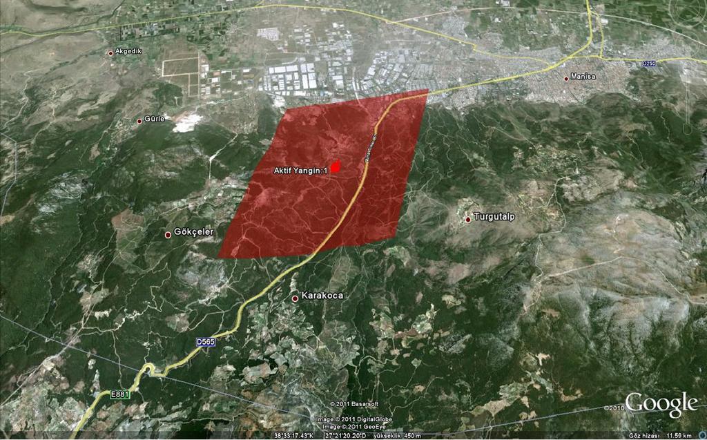

20 Google-Earth representation
21 Google-Earth representation From an operational( fire fighters) point of view, Google-Earth visualization is useful for; gathering information about related site vegetation type/cover underneath the satellite footprint determination of the fire fighting strategy accessibility information to the fire place potential skimming water locations, such as lakes, reservoirs or rivers, for refilling tanks/carry buckets

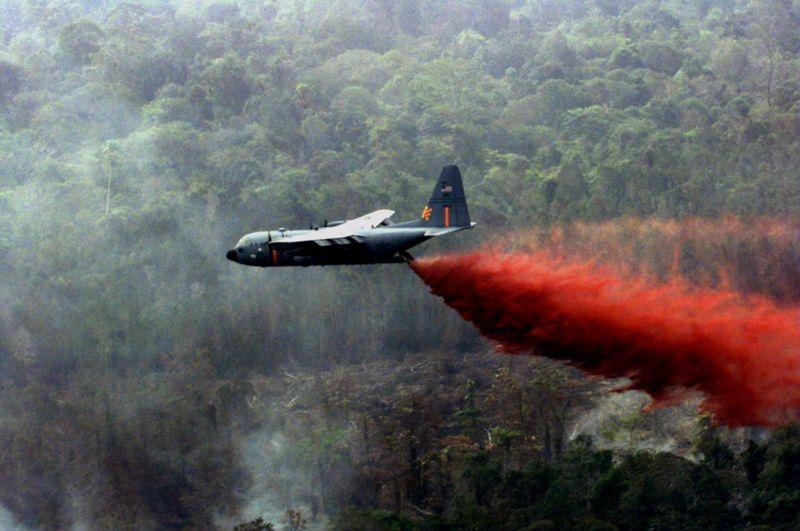

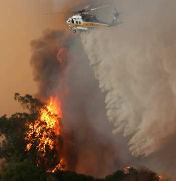

22 Aerial firefighting Helicopters & Airtankers are commonly used


23 Aerial firefighting Tanks/Carry Buckets needed to be refilled


24 Aerial firefighting Also useful in determination of water sources.
25 Summary/Conclusion Google-Earth: enables interaction of the geographic info and the corresponding research data helps to determine the fire fighting strategy provides info; about the accessibility & vegetation type/cover of the fire site potential skimming water locations, such as lakes, reservoirs or rivers, for refillingg tanks/carry buckets

26 Comments/Questions
PARALLEL USE OF SEVIRI LSA SAF FRP AND MPEF FIR PRODUCTS FOR FIRE DETECTION AND MONITORING
 PARALLEL USE OF SEVIRI LSA SAF FRP AND MPEF FIR PRODUCTS FOR FIRE DETECTION AND MONITORING C. G. Georgiev, J. S. Stoyanova National Institute of Meteorology and Hydrology, Bulgarian Academy of Sciences
Session 2: LSA-SAF evapotranspiration: files, format and applications
 Application of remote sensing data for drought monitoring Introduction to EUMETSAT Land SAF products Wednesday November 13, 2013 Session 2: LSA-SAF evapotranspiration: files, format and applications 1.
Supplement of LSA SAF Meteosat FRP products Part 1: Algorithms, product contents, and analysis
 Supplement of Atmos. Chem. Phys., 15, 13217 13239, 2015 http://www.atmos-chem-phys.net/15/13217/2015/ doi:10.5194/acp-15-13217-2015-supplement Author(s) 2015. CC Attribution 3.0 License. Supplement of
Global fire hotspots detected by NASA satellite to help United Nations
 Global fire hotspots detected by NASA satellite to help United Nations Published on 24 Sep 2010 is Image NASA's not found Moderate or type unknown Resolution Imaging Spectroradiometer (MODIS), an instrument
A temporal active fire detection algorithm applied to geostationary satellite observations
 8 th 10 th June LSA-SAF Workshop 2015 A temporal active fire detection algorithm applied to geostationary satellite observations Gareth Roberts (University of Southampton) Outline Active fire detection
FIRE DETECTION AND MONITORING USING AVHRRA AND MSG SYSTEMS. Version Tuesday, 1.0, 1530 November Slide: 1
 FIRE DETECTION AND MONITORING USING AVHRRA AND MSG SYSTEMS Version Tuesday, 1.0, 1530 November 2005 2004 Slide: 1 Botswana early warning system Version Tuesday, 1.0, 1530 November 2005 2004 Slide: 2 Objectives
Soil moisure, vol. % Precipitation, in. BSEN 4210 Irrigation HW 2 Daily Rainfall and Soil Moisture Ann Nunnelley 4 Sept. 2015
 BSEN 4210 Irrigation HW 2 Daily Rainfall and Ann Nunnelley 4 Sept. 2015 The following graphs and tables represent the precipitation and soil properties from the Princeton#1 SCAN site (site# 2005) located
Physical concepts. Remote sensing of fires and vegetation. Applications of SEVIRI channels.
 Physical concepts Remote sensing of fires and vegetation Applications of SEVIRI channels jose.prieto@eumetsat.int Contents Applications of SEVIRI channels Characteristics of the 3.9µm channel Differences
Fire Information for Resource Management System (FIRMS)
") Fire Information for Resource Management System (FIRMS) Diane Davies 1, Chris Justice 1, Jacques Descloitres 2, John Latham 3 John Musinsky 4 1 Department of Geography, University of Maryland 2 SSAI /
Fire Information for Resource Management System (FIRMS) Diane Davies 1, Chris Justice 1, Jacques Descloitres 2, John Latham 3 John Musinsky 4 1 Department of Geography, University of Maryland 2 SSAI /
University of Puerto Rico at Mayagüez Direct Broadcast Polar Orbiter Workshop
 University of Puerto Rico at Mayagüez Direct Broadcast Polar Orbiter Workshop 27 April 2016 Lab 2 Part 4: Investigating VIIRS and MODIS Fire Detection Capabilities 1.1. Use Hydra to open the VIIRS directory
SEVIRI/MSG sensor early fire detection performances assessment
 SEVIRI/MSG sensor early fire detection performances assessment G. Laneve, E. Cadau CRPSM Università di Roma La Sapienza e-mail: laneve@psm.uniroma1.it 2 nd GOFC/GOLD Workshop on GEO Fire Monitoring, Darmstadt,
Solution for Distribution Pipelines
 Gas Leak Detection by SELMA Methane Methane Solution for Distribution Pipelines About Pergam-Suisse AG Specializing in natural gas leak detection and NDT products and services worldwide International distributor
The operational MSG SEVIRI fire radiative power products generated at the Land-SAF
 Environmental Monitoring & Modelling Research Group The operational MSG SEVIRI fire radiative power products generated at the Land-SAF Martin Wooster, Gareth Roberts, Weidong Xu, Patrick Freeborn, Jianping
Semi-automated scores of urbanization
 System Requirements Supported Operating Systems: Windows 8, Windows 7, Windows Vista Microsoft.NET Framework 3.5 (available for download: http://www.microsoft.com/enus/download/confirmation.aspx?id=21)
Land SAF LSA-SAF Evapotranspiration (ET) Product
 Product") Land SAF LSA-SAF Evapotranspiration (ET) Product Alirio Arboleda Budapest 25 April 2017 In collaboration with: Nicolas Ghilain and Françoise Gellens-Meulenberghs Royal Météorological Institute of Belgium
Land SAF LSA-SAF Evapotranspiration (ET) Product Alirio Arboleda Budapest 25 April 2017 In collaboration with: Nicolas Ghilain and Françoise Gellens-Meulenberghs Royal Météorological Institute of Belgium
Evaluating Chicago s Urban Heat Island Policy with Remote Sensing. Chris Mackey
 Evaluating Chicago s Urban Heat Island Policy with Remote Sensing Chris Mackey The Heat Island Effect When a large urban area is a few degrees warmer than its surrounding rural area. Composed from LANDSAT
This definition is from the Soil Science Glossary (Soil Science Society of America).
.") What is Soil? This definition is from the Soil Science Glossary (Soil Science Society of America). soil - (i) The unconsolidated mineral or organic material on the immediate surface of the earth that serves
What is Soil? This definition is from the Soil Science Glossary (Soil Science Society of America). soil - (i) The unconsolidated mineral or organic material on the immediate surface of the earth that serves
There are various resources and toolkits available to perform this task.
 Hands-On Exercise: Wildfires in Chile, January 2017 Task description Imagine you are analyst that has been assigned to the fire Las Maquinas burning in the vicinity of Constitución, in the Maule region
As agreed to by the members of the Routt County Multi-Agency Coordinating (MAC) Advisory and Policy Groups on March 15, 2018.
 Advisory and Policy Groups on March 15, 2018.") As agreed to by the members of the Routt County Multi-Agency Coordinating (MAC) Advisory and Policy Groups on March 15, 2018. Remember the 10 STANDARD FIRE ORDERS and the 18 situations that shout WATCH
As agreed to by the members of the Routt County Multi-Agency Coordinating (MAC) Advisory and Policy Groups on March 15, 2018. Remember the 10 STANDARD FIRE ORDERS and the 18 situations that shout WATCH
GIS Training of Undergraduates: Campus Stormwater Mapping. Joanne Logan, University of Tennessee. Gordie Bennett, University of Tennessee
 GIS Training of Undergraduates: Campus Stormwater Mapping Joanne Logan, University of Tennessee Gordie Bennett, University of Tennessee Seth Benge, University of Tennessee Tim Prather, University of Tennessee
Spacing Average distance between seeds in a given row of planted seeds. Results are expressed in inches.
 Purpose: The purpose of the Field Seed Spacing Template is to provide a tool to gather information on seeds that have been planted. The results provide a numerical evaluation of the plant population and
COMMUNITY WILDFIRE PROTECTION PLAN POWELL RIVER REGIONAL DISTRICT
 COMMUNITY WILDFIRE PROTECTION PLAN POWELL RIVER REGIONAL DISTRICT OUTLINE Introduction/Background Information CWPP Planning Structure Brief Overview of the WRMS Results Recommendations/Action Plan INTRODUCTION
Global Biomass Burning Emissions from a Constellation of Geostationary Satellites for Global Model Forecast Applications
 1 Global Biomass Burning Emissions from a Constellation of Geostationary Satellites for Global Model Forecast Applications Shobha Kondragunta NOAA/NESDIS Center for Satellite Applications and Research
Milkweed & Monarch Data Collection Sheets 2016
 Milkweed & Monarch Data Collection Sheets 2016 Please fill out the following fields. When finished please enter the data into one of our digital reporting tools found at www.xerces.org/milkweedsurvey Observer
Use of new spatially refined satellite remote sensing fire detection data in support of advanced wildfire mapping and modeling
 Use of new spatially refined satellite remote sensing fire detection data in support of advanced wildfire mapping and modeling Dr. Wilfrid Schroeder 1 Dr. Janice Coen 2 Dr. Patricia Oliva 1 Dr. Louis Giglio
EMERGENCY ACTION PLAN
 EMERGENCY ACTION PLAN Lake Sunapee Dam Sunapee, NH Dam #229.04 (Class B Dam) Water Division Lake Sunapee Dam - Sunapee, NH TABLE OF CONTENTS Section 1 Section 2 Section 3 Section 4 Notification Flowchart
Overview of the WF_ABBA Global Geostationary Fire Monitoring Program: Current Implementation and Future Plans
 Overview of the WF_ABBA Global Geostationary Fire Monitoring Program: Current Implementation and Future Plans Elaine M. Prins Consultant Christopher C. Schmidt Jay Hoffman Jason Brunner UW-Madison SSEC
GOES-R AWG Land Team: Fire Detection and Characterization
 GOES-R AWG Land Team: Fire Detection and Characterization June 8, 2010 Presented By: Christopher C. Schmidt 1 1 UW-Madison/SSEC/CIMSS 1 FIRE Product Team AWG Land Team Chair: Yunyue (Bob) Yu FIRE Product
Automated Fire and Flood Hazard Protection System
 De la Riva, J., Pérez-Cabello, F. & Chuvieco, E. (Eds) 2005 Proceedings of the 5 th International Workshop on Remote Sensing and GIS Applications to Forest Fire Management: Fire Effects Assessment: 167-172
DETECTION AND MONITORING OF ACTIVE FIRES USING REMOTE SENSING TECHNIQUES
 DETECTION AND MONITORING OF ACTIVE FIRES USING REMOTE SENSING TECHNIQUES Source: Unknown n.d., http://www.hotrodsandclassics.net/featuredpictures/featurepictures2.htm. by Claire Riddell DETECTION AND MONITORING
Letter of Notification For East Lima Station Expansion Project
 Letter of Notification For East Lima Station Expansion Project PUCO Case No. 18-0906-EL-BLN Submitted to: The Ohio Power Siting Board Pursuant to Ohio Administrative Code Section 4906-6-05 Submitted by:
DTSX200 Communications(Modbus) Guide
 Guide") User s Manual DTSX200 Communications(Modbus) Guide 4th Edition Blank Page < Introduction > i Introduction About this Manual Thank you for purchasing the DTSX200 Distributed Temperature Sensor. This document
User s Manual DTSX200 Communications(Modbus) Guide 4th Edition Blank Page < Introduction > i Introduction About this Manual Thank you for purchasing the DTSX200 Distributed Temperature Sensor. This document
National Certificate in Fire and Rescue Services (Vegetation) (Level 4)
 (Level 4)") NZQF NQ Ref 1183 Version 3 Page 1 of 6 National Certificate in Fire and Rescue Services (Vegetation) (Level 4) Level 4 Credits 47 This qualification is expiring. The last date to meet the requirements
NZQF NQ Ref 1183 Version 3 Page 1 of 6 National Certificate in Fire and Rescue Services (Vegetation) (Level 4) Level 4 Credits 47 This qualification is expiring. The last date to meet the requirements
Follow the Drop. Activity Overview Students observe and collect information about water runoff on their school property.
 Follow the Drop Activity Overview Students observe and collect information about water runoff on their school property. Objective Students will: 1. Practice observation and investigative skills 2. Survey
Tore Eriksson. CTIF President. Deputy Head Command & Control and Decision Support Division Swedish Civil Contingencies Agency.
 Tore Eriksson CTIF President Deputy Head Command & Control and Decision Support Division Swedish Civil Contingencies Agency tore.eriksson@msb.se International Association of Fire and Rescue Services Founded
Fire Detection and Prediction Systems of
 JPTM2013, Bangkok, Thailand, 27-2929, Nov. 2013 Fire Detection and Prediction Systems of Peat-Forest t Fires in JST-JICA JSTJICA Project Toshihisa Honma, Kazuya Kaku 1, Aswin Usup 2 and 3 Agus Hidayat
Using VIIRS Direct Readout Capabilities for the Improvement of Mexico's Wild Fire Alert System
 Using VIIRS Direct Readout Capabilities for the Improvement of Mexico's Wild Fire Alert System Juan M. Escamilla Mólgora 1 National Commission for Knowledge and Use of Biodiversity CONABIO - Mexico 1 CSPP/IMAPP
Airborne Imagery Potential Role in Monitoring Climate Change
 PC.DEL/773/09 13 October 2009 ENGLISH only Airborne Imagery Potential Role in Monitoring Climate Change US Department of State 5 October 2009 Briefing Topics Introduction Climate Change Threats to National
Inspection Report: Berryville Collection System, AFIN: , Permit #: AR FACILITY TYPE: 1 - Municipal
 FACILITY INFORMATION NAME: Berryville Collection System LOCATION: CITY: Berryville RESPONSIBLE OFFICIAL NAME: / TITLE Honorable Tim McKinney / Mayor COMPANY: City of Berryville MAILING ADDRESS: P.O. Box
Cloud and Banner Mitigation Site Latitude: 36 8' 38.41" N Longitude:79 16' 16.14" W
 Cape Fear River Basin HUC 03030002 Not to Scale Latitude: 36 8' 38.41" N Longitude:79 16' 16.14" W ^_ Latitude: 35 58' 30.37" N Longitude:79 11' 10.77" W ^_ Document Path: C:\Users\Brad\Dropbox (RES)\@RES
Course Outline Cover Page
 College of Micronesia FSM P.O. Box 159 Kolonia, Pohnpei Course Outline Cover Page Advanced Fire Control and Prevention MM 173 Course Title Department and Number Course Description: To provide candidates
The Apogee Scientific. Advanced Leak Detection Technology
 An Introduction to The Advanced Leak Detection Technology , Inc Innovative Technology Development Advanced Leak Detection Technologies Commercialized and Proven Oil and Gas Detection Services Leak Detection
Review of MTG FDHSI Mission Requirements Regarding Fire Applications
 Review of MTG FDHSI Mission Requirements Regarding Fire Applications Dr M.J. Wooster and Dr G. Roberts Environmental Monitoring and Modelling Group, Department of Geography King s College London Document
A Data Set for Fire and Smoke Model Development and Evaluation-- RxCADRE
 Data Set for Fire and Smoke Model Development and Evaluation-- RxCDRE Roger Ottmar Pacific Wildland Fire Sciences Laboratory Pacific Northwest Research Station Seattle, W RxCDRE History 2007--Core Fire
Welcome to MultiSight TM Vision Sensor Hands-On Lab
 Welcome to MultiSight TM Vision Sensor Hands-On Lab About This Hands-On Lab Welcome to the MultiSight TM Vision Sensor Hands-On Lab! This session provides you with an opportunity to explore the functionality
Presentation August 20, 2013
 Presentation August 20, 2013 St. Vital Transmission Complex Stakeholder Workshop WELCOME! Manitoba Hydro 9:00am to 1:50pm Purpose of Workshop Share current project information Including outcomes of the
The Role of Satellite Observations in Assessing Impacts of Wildfire Occurrence on Respiratory Health of Population
 The Role of Satellite Observations in Assessing Impacts of Wildfire Occurrence on Respiratory Health of Population Tatiana Loboda University of Maryland Outline Wildfire and human health Interdisciplinary
Recent Developments and Prospects for Innovative Remote Sensing of High-Temperature Events and Vegetation Fire Impacts
 Recent Developments and Prospects for Innovative Remote Sensing of High-Temperature Events and Vegetation Fire Impacts by D. Oertel, E. Lorenz, B. Zhukov German Aerospace Center, (DLR-OS) Berlin Adlershof
PhD Candidate, Université Paris-Est (France) and Institut d Urbanisme de l ALBA - Univerité de Balamand (Lebanon) 2
 and Institut d Urbanisme de l ALBA - Univerité de Balamand (Lebanon) 2") Noushig Kaloustian 1, Youssef Diab 2, Benjamin Bechtel 3, Jürgen Ossenbrügge 3 1 PhD Candidate, Université Paris-Est (France) and Institut d Urbanisme de l ALBA - Univerité de Balamand (Lebanon) 2 Professor,
Noushig Kaloustian 1, Youssef Diab 2, Benjamin Bechtel 3, Jürgen Ossenbrügge 3 1 PhD Candidate, Université Paris-Est (France) and Institut d Urbanisme de l ALBA - Univerité de Balamand (Lebanon) 2 Professor,
Long-term Inventory of Fire Burned Areas and Emissions of North America s Boreal and Temperate Forests
 Long-term Inventory of Fire Burned Areas and Emissions of North America s Boreal and Temperate Forests P.Gong, Z. Li, I. Csiszar, W. Hao, R. Fraser J.Z. Jin, R. Pu Objectives 1. Map burn scars in boreal
Deployment of IBP material caused by the sinking of a floating roof of large oil storage tank
 Deployment of IBP material caused by the sinking of a floating roof of large oil storage tank drs. Erwin de Bruin, operational manager ing. Raymond Bras, manager special projects Theme s of the presentation
DOD FIRE SERVICE CERTIFICATION SYSTEM LESSON PLAN 7. Fire Alarm and Communication
 DOD FIRE SERVICE CERTIFICATION SYSTEM LESSON PLAN 7 Personnel Classification: Subject: Lesson Length: Level of Instruction: Job Performance Requirement: NFPA 1001 Objectives Fire Fighter I Fire Alarm and
7th Avenue Creek Master Plan Development Project. City of St. Charles, IL. IAFSM CONFERENCE March 14, 2018 MARKET
 7th Avenue Creek Master Plan Development Project MARKET City of St. Charles, IL IAFSM CONFERENCE March 14, 2018 7 TH AVENUE CREEK PROJECT AREA 2 2008 RAIN EVENT 3 RESIDENTIAL STRUCTURE FLOODING COMMERCIAL
Advisor Advanced Mobile Application User Manual
 Advisor Advanced Mobile Application User Manual Content Warnings and Disclaimers 2 Advanced Mobile 2 Contact information 2 Description 2 Screen navigation 4 Gestures 4 Menu 4 Help navigation 4 Login 5
LOW IMPACT DEVELOPMENT GUIDANCE MANUAL AND LID WORKING GROUP ACTIVITIES. Powerpoint Templates. MS4 Statewide Stormwater Summit June 18, 2013
 LOW IMPACT DEVELOPMENT GUIDANCE MANUAL AND LID WORKING GROUP ACTIVITIES MS4 Statewide Stormwater Summit June 18, 2013 Powerpoint Templates Evan Canfield, Ph.D, P.E. Pima County Regional Flood Control Outline
Ozone and Atmospheric Chemistry Monitoring SAF (O3M SAF)
") Ozone and Atmospheric Chemistry Monitoring SAF (O3M SAF) EUMETSAT SAF Network Workshop 14-16 January 2008 Jukka Kujanpää, FMI Overview of O3M SAF SAF on Ozone and Atmospheric Chemistry Monitoring Part
Ozone and Atmospheric Chemistry Monitoring SAF (O3M SAF) EUMETSAT SAF Network Workshop 14-16 January 2008 Jukka Kujanpää, FMI Overview of O3M SAF SAF on Ozone and Atmospheric Chemistry Monitoring Part
From Marine Pollution to Inland. Wildfire Mapping
 From Marine Pollution to Inland Louis Armstrong Wildfire Mapping The Mobilization of the National Aerial Surveillance Program (NASP) in support of the Fort McMurray Wildfires TC Chief, Intelligence, Surveillance
IFLA Guidelines for Satellite Meetings. Approved by the IFLA Professional Committee and the IFLA Governing Board August 2012
 IFLA Guidelines for Satellite Meetings Approved by the IFLA Professional Committee and the IFLA Governing Board August 2012 Appendix updated March 2017 Introduction Satellite Meetings allow IFLA Professional
CAMDEN COUNTY FIRE COORDINATOR
 SECTION OPERATIONS EFFECTIVE REVISED 02-20-19 SOG 3-1 CAMDEN COUNTY FIRE COORDINATOR Purpose To establish an appointment protocol for the Camden County Fire Coordinator, and Deputy Camden County Fire Coordinator
UCLA Policy 130: Emergency Notifications (BruinAlert) DRAFT FOR PUBLIC REVIEW
 DRAFT FOR PUBLIC REVIEW") UCLA Policy 130: Emergency Notifications (BruinAlert) DRAFT FOR PUBLIC REVIEW Issuing Officer: Administrative Vice Chancellor Responsible Department: Office of Emergency Management Effective Date: TBD
UCLA Policy 130: Emergency Notifications (BruinAlert) DRAFT FOR PUBLIC REVIEW Issuing Officer: Administrative Vice Chancellor Responsible Department: Office of Emergency Management Effective Date: TBD
ISO 6183 INTERNATIONAL STANDARD. Fire protection equipment Carbon dioxide extinguishing systems for use on premises Design and installation
 INTERNATIONAL STANDARD ISO 6183 Second edition 2009-06-15 Fire protection equipment Carbon dioxide extinguishing systems for use on premises Design and installation Équipement de protection contre l'incendie
M E M O R A N D U M July 27, 2018
 M E M O R A N D U M July 27, 2018 To: Southlake 2035 Corridor Planning Committee From: Kenneth Baker, Sr. Director of Planning and Development Services Subject: Item #6 First National Bank Purpose Review,
3. Managing smoke: Our strategies and opportunities
 3. Managing smoke: Our strategies and opportunities Dr. Zifei Liu zifeiliu@ksu.edu Pasture burning smoke management and air quality workshop March 28 th, 2015 Engineering Two strategies for reduction Minimize
The features of our Project
 Urban Renaissance Agency, Japan KOSHIGAYA LAKE TOWN PROJECT Smart & Sustainable Urban Life with the Lake The features of our Project The Lake is crucial for heat-island phenomena. The Lake must open to
Citywide Integrated Stormwater Management Plan (ISMP) DRAFT ACTION PLAN REVIEW Public Consultation November 16 th, 2016
 DRAFT ACTION PLAN REVIEW Public Consultation November 16 th, 2016") Citywide Integrated Stormwater Management Plan (ISMP) DRAFT ACTION PLAN REVIEW Public Consultation November 16 th, 2016 1 Agenda DRAFT ACTION PLAN REVIEW Public Consultation Time 6:00 6:05 6:05 6:20 6:20
Citywide Integrated Stormwater Management Plan (ISMP) DRAFT ACTION PLAN REVIEW Public Consultation November 16 th, 2016 1 Agenda DRAFT ACTION PLAN REVIEW Public Consultation Time 6:00 6:05 6:05 6:20 6:20
Evaluation of How O&M Costs Vary for Alternative Flood Control Strategies
 Evaluation of How O&M Costs Vary for Alternative Flood Control Strategies Fargo-Moorhead Diversion Channel ASFPM Conference June 13, 2013 Matt Redington, PE Jeremy Cook HDR Engineering Red River of the
LETTER TO Family. Science News. Cut here and paste onto school letterhead before making copies.
 LETTER TO Family Cut here and paste onto school letterhead before making copies. Dear Family, Water is a unique earth material, the only material on Earth that occurs naturally in all three states of matter:
Observations of the Coulson Martin Mars and FireWatch 76 Operations on the 2011 Wildfires in Mexico. Jim Thomasson Contract Report CR-TBD
 Wildfire Operations Research 1176 Switzer Drive Hinton, AB T7V 1V3 Observations of the Coulson Martin Mars and FireWatch 76 Operations on the 2011 Wildfires in Mexico Jim Thomasson 2011 Contract Report
Tree Health Answers & Questions Good or new questions are published
 www.thefraqs.org Tree Health Answers & Questions Good or new questions are published Sudden Oak Death New disease caused by an exotic pathogen introduced in CA in teh late 80s probably from Asia through
A CASE STUDY OF LANDSCAPE ANALYSIS WITH HIGH-RESOLUTION SATELLITE IMAGERY IN OLEIROS (A CORUÑA, SPAIN)
") A CASE STUDY OF LANDSCAPE ANALYSIS WITH HIGH-RESOLUTION SATELLITE IMAGERY IN OLEIROS (A CORUÑA, SPAIN) Gil Docampo, Mª Luz a ; Corbelle Rico, Eduardo b ; López Rodríguez, Andrés c a, b, c Departamento
A CASE STUDY OF LANDSCAPE ANALYSIS WITH HIGH-RESOLUTION SATELLITE IMAGERY IN OLEIROS (A CORUÑA, SPAIN) Gil Docampo, Mª Luz a ; Corbelle Rico, Eduardo b ; López Rodríguez, Andrés c a, b, c Departamento
Advanced Fire Information System
 Advanced Fire Information System Karen Steenkamp Philip Frost CSIR Meraka Institute www.sac.co.za Meraka Institute - RSRU RSRU Mission: To conduct basic and applied remote sensing research for the advancement
Laptop / PC Programming Manual
 Laptop / PC Programming Manual Doc. # Fire PC Program rev B 01.07 This Document is property of Evax Systems, Inc. The Evax Fire Solutions Programmer Components 2 1.0 System Setup 4 1.1 Interface Setup
Acquisition and Collection Development Section
 Acquisition and Collection Development Section ACTION PLAN 2011-2013 REVISED SEPTEMBER 2010 REVISED AND ANNOTATED AUGUST 2012 Background information The Acquisition and Collection Development Section focuses
UBC Social Ecological Economic Development Studies (SEEDS) Sustainability Program. Student Research Report
 Sustainability Program. Student Research Report") UBC Social Ecological Economic Development Studies (SEEDS) Sustainability Program Student Research Report UBC Botanical Gardens Mapping Manual Amanda Leslie, Emma Cunningham, Gary Pinneo, Lauren Tekano,
UBC Social Ecological Economic Development Studies (SEEDS) Sustainability Program Student Research Report UBC Botanical Gardens Mapping Manual Amanda Leslie, Emma Cunningham, Gary Pinneo, Lauren Tekano,
Demands on Electro-optical Cameras for Sensing and Mapping
 Claus 37 Demands on Electro-optical Cameras for Sensing and Mapping MICHAEL CLAUS, Oberkochen ABSTRACT Electro-optical cameras installed in satellites circling the globe at altitudes of several 100 kilometers
A Terrarium (Sessions I and II)
") activities 14&15 A Terrarium (Sessions I and II) BROWARD COUNTY ELEMENTARY SCIENCE BENCHMARK PLAN Grade 3 Quarter 2 Activities 14 & 15 SC.D.1.2.3 The student knows that the water cycle is influenced by
activities 14&15 A Terrarium (Sessions I and II) BROWARD COUNTY ELEMENTARY SCIENCE BENCHMARK PLAN Grade 3 Quarter 2 Activities 14 & 15 SC.D.1.2.3 The student knows that the water cycle is influenced by
Davis Soil Moisture and Temperature Station Protocol
 Davis Soil Moisture and Temperature Station Protocol Purpose To log soil data using a Davis soil moisture and temperature station Overview Soil moisture and temperature sensors are installed at multiple
Science Class 6 Chapters 13, 14 and
 Chapter 13 Fun with Magnets Magnetic field of the Earth: Geographical North is Magnetic South and vice versa Two places where the magnetic needle becomes vertical are called the magnetic poles. The magnetic
Fire & Smoke Fire Only Smoke Only
 BCC Fire Generator Fire is an auto-animated procedural fire effect which offers control over flame width and height, color, and movement, and allows you to generate smoke. This filter can use the alpha
Redesigning Vogel Flat Angeles National Forest, California
 Redesigning Vogel Flat Angeles National Forest, California WRPI Watershed Management Internship 2017 Cristina Plemel, Master s of Landscape Architecture California State Polytechnic University, Pomona
POSITION VACANCY NOTICE CITY OF KETCHIKAN
 POSITION VACANCY NOTICE CITY OF KETCHIKAN May 19, 2016 SPECIFICS TITLE: VOLUNTEER FIREFIGHTER / EMT DEPARTMENT: FIRE DIVISION: Operations STATUS: Volunteer HOURS/DAYS: GRADE/STEP: DUTIES: See attached
NORTHEAST AIR ALLIANCE. SMOKE MANAGEMENT PLAN For Butte, Lassen, Modoc, Plumas, Shasta, Siskiyou, Tehama
 Appendix C NORTHEAST AIR ALLIANCE For Butte, Lassen, Modoc, Plumas, Shasta, Siskiyou, Tehama In accordance with the Air District s Smoke Management Program, this Smoke Management Plan (SMP) is to be completed
Knowledge Management Section ANNUAL REPORT
 Knowledge Management Section ANNUAL REPORT 2016-2017 Introduction Professional Units must prepare an Annual Report each year. It has been agreed by the Governing Board that this can cover the period September
Interim evaluation of the New IR Sensor Technology (NIRST) as a wildfire monitoring tool
 as a wildfire monitoring tool") Interim evaluation of the New IR Sensor Technology (NIRST) as a wildfire monitoring tool Joshua Johnston Forest Fire Analyst Canadian Forest Service Great Lakes Forestry Centre Sault Ste. Marie, Ontario
Interim evaluation of the New IR Sensor Technology (NIRST) as a wildfire monitoring tool Joshua Johnston Forest Fire Analyst Canadian Forest Service Great Lakes Forestry Centre Sault Ste. Marie, Ontario
Public Services. NewVoice. San Francisco Paris Geneva Zurich Linz Mainz Shanghai Brisbane Hong Kong São Paulo Dubai
 Public Services NewVoice San Francisco Paris Geneva Zurich Linz Mainz Shanghai Brisbane Hong Kong São Paulo Dubai Public Services - Mobile applications for smart phones - Emergency Call 911 - Municipality
Landowner's Guide to the Lower St. Croix Riverway. Protect. Restore. Celebrate. stcroixriverassociation.org
 Landowner's Guide to the Lower St. Croix Riverway Protect. Restore. Celebrate. stcroixriverassociation.org Cover and page spread photographs by Craig Blacklock. For more information on how to be a river
Site Inspection Protocol and Procedures: Mazama Pocket Gopher
 Site Inspection Protocol and Procedures: Mazama Pocket Gopher The following information describes the Thurston County screening protocol for 2018 to assess the likelihood of take of three subspecies of
GOES-R ABI Emissive IR Bands Radiometric Performance Monitoring and Trending
 GOES-R ABI Emissive IR Bands Radiometric Performance Monitoring and Trending Haifeng Qian a, Robert Iacovazzi a, Xiangqian Wu b, Boryana Efremova a, Fangfang Yu a, Xi Shao a a ERT, Inc. Laurel, MD 20707
IOP , 1200 UTC UTC
 IOP-21 Summary of Operations 21 February 2010, 1200 UTC 22 February 2010 1200 UTC Authors: Rauber, Brown, Knupp, Market 1. Summary of storm evolution The IOP-21 storm formed as a weak wave moved out of
Brigitte A. Berger, Director of Engineering
 Brigitte A. Berger, Director of Engineering Wilmette s Sewer System Overview of Wilmette s Sewer System Green vs. Gray? Stormwater Action Plan Regulatory Compliance Why Homes Flood What can
PUBLIC NOTIFICATION PLAN
 VILLAGE OF LA GRANGE, ILLINOIS NPDES PERMIT NO. ILM580009 COMBINED SEWER OVERFLOW PUBLIC NOTIFICATION PLAN NATIONAL POLLUTANT DISCHARGE ELIMINATION SYSTEM PROGRAM ILLINOIS ENVIRONMENTAL PROTECTION AGENCY
presentations the week of the final exams. Anyone who misses the appointment will receive a grade of zero.
 CS 116 Section 4 PROJECT Spring 2016 Grade: Up to 12 points. Rules: To be worked on individually. Must be presented to the instructor in person in order to be graded. Similar projects will both receive
Integrating LEED ND & SITES Into Your Design Approach
 Integrating LEED ND & SITES Into Your Design Approach Joshua C. Sloan, RLA, ASLA, AICP, LEED AP ND, SITES AP Stephen K. Cook, RLA, ASLA, LEED AP O+M VIKA MD, LLC Planning Landscape Architecture Engineering
Praxis II/Content Area Knowledge: Comparative Performance Summary
 Praxis II test battery performance data; Passing Passing Passing Passing 2014- Test # testers Score St.Dev. * testers Score St.Dev. * tests) testers Score St.Dev. * tests) testers Score St.Dev. * tests)
International Journal of Scientific & Engineering Research, Volume 7, Issue 7, July ISSN
 International Journal of Scientific & Engineering Research, Volume 7, Issue 7, July-2016 554 Forest Fire Detection using Wireless Sensor Harjinder Singh Department of Instrumentation and Control Engineering,
Rule 11 Drought Management
 Rule 11 Drought Management Rule 11.1 Determination of Waste Water uses regulated or prohibited under this Rule are considered to be nonessential and continuation of such uses during times of water restrictions,
Fire Detection and Monitoring
 Fire Detection and Monitoring Akli Benali Forest Research Center, University of Lisbon aklibenali@gmail.com Conference & Summer School on Forest Fire Management Istituto Superiore Antincendi, Rome, September
BCGEU JOB DESCRIPTION MINISTRY OF FORESTS
 POSITION TITLE: Forest Protection Assistant BRANCH / REGION / DISTRICT: Protection Program, Fire Zones NOC CODE: 2223 SUPERVISOR S POSITION TITLE: Forest Protection Officer CURRENT CLASSIFICATION / GRID:
Honeywell s Integrated Approach to Sustainability
 Honeywell s Integrated Approach to Sustainability Evan van Hook October 2012 Sustainability Integrated On Two Vectors 1. Products and Services - Very significant proportion of what we sell relates to the
Project Report Cover Page
 New York State Pollution Prevention Institute R&D Program 2016-2017 Student Competition University/College Name Team Name Team Member Names Project Report Cover Page University at Buffalo Campus Garden